1
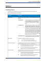
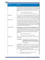
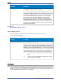
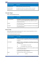
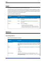
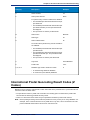
Options
Parameter
Description
• Meters
• Kilometers
The default is Meters.
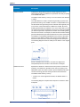
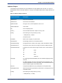
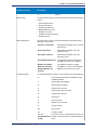
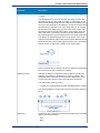
CoordinateSystem
A coordinate system is a reference system for the unique location of a
point in space. Cartesian (planar) and Geodetic (geographical)
coordinates are examples of reference systems based on Euclidean
geometry. Spectrum™ Technology Platform supports systems recognized
by the European Petroleum Survey Group (EPSG).
Each country supports different coordinate systems. Depending on the
country, you have one or more of the following options:
EPSG:4326
Also known as the WGS84 coordinate system.
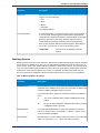
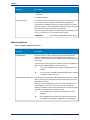
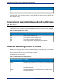
Matching Options
Table 11: Matching Options for Greece
Parameter
Description
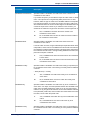
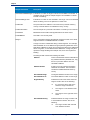
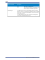
KeepMultimatch
Specifies whether to return results when the coordinates match to
multiple candidate addresses in the database. If this option is not
selected, coordinates that results in multiple address candidates will fail
to geocode.
If you select this option, specify the maximum number of candidates to
return using the MaxCandidates option (see below).
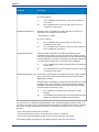
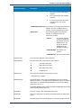
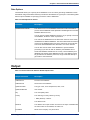
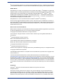
SortCandidatesUsingLocale
Y
Yes, return candidates when multiple candidates are found.
Default.
N
No, do not return candidates. Addresses that result in multiple
candidates will fail to geocode.
This Reverse geocoding option that applies to Greece, Russia, Ukraine,
and any other country that supports dual character sets (such as the
Middle East countries).
Specifies whether candidates are sorted and returned based on the
input language. That is, if the input was in Russian, the Russian
character candidate is returned first followed by the English language
candidate. This will override the dictionary order.
26
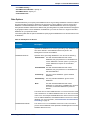
Y
Yes, candidates are sorted and returned based on input
language.
N
No, candidates are returned in the order that the dictionary
was added to the database, regardless of input language.
Spectrum Technology Platform 9.0 SP1