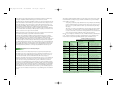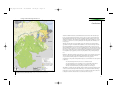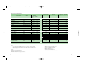
1
Page 1
GLOBAL FOREST WATCH (GFW)
The State of Venezuela’s Forests
WORLD RESOURCES INSTITUTE (WRI)
ACOANA
A Case Study of the Guayana Region
UNEG
PROVITA
FUDENA
FUNDACIÓN POLAR
GLOBAL FOREST WATCH
09:20 pm
GLOBAL FOREST WATCH
25/06/2002
The State of Venezuela’s Forests. A Case Study of the Guayana Region •
ArtePortada
Págs i-xvi
25/06/2002
02:09 pm
Page i
The State of Venezuela’s Forests
A Case Study of the Guayana Region
A Global Forest Watch Report prepared by:
Mariapía Bevilacqua, Lya Cárdenas, Ana Liz Flores, Lionel Hernández,
Erick Lares B., Alexander Mansutti R., Marta Miranda, José Ochoa G.,
Militza Rodríguez, and Elizabeth Selig
Págs i-xvi
25/06/2002
02:09 pm
Page ii
AUTHORS:
Forest Cover and Protected Areas:
Mariapía Bevilacqua (ACOANA)
and Marta Miranda (WRI)
Wildlife:
José Ochoa G. (ACOANA/WCS)
Non-Timber Forest Products:
Lya Cárdenas
Logging:
Lionel Hernández (UNEG)
Mining:
Marta Miranda (WRI) and Ana Liz Flores
Settlements:
Alexander Mansutti R. (UNEG)
Geographic Information Systems:
Elizabeth Selig (WRI)
Erick Lares B. (Populations) (UNEG)
Militza Rodríguez (Logging concessions)
(UNEG)
Presentation
Each World Resources Institute
report represents a timely, scholarly
treatment of a subject of public concern. WRI takes responsibility for
choosing the study topics and guaranteeing its authors and researchers
freedom of inquiry. It also solicits
and responds to the guidance of
advisory panels and expert reviewers. Unless otherwise stated, however, all the interpretation and findings set forth in WRI publications
are those of the authors.
Copyright © 2002
World Resources Institute.
All rights reserved.
ISBN 1-56973-508-5 (English)
ISBN 1-56973-509-3 (Spanish)
Editor:
Marta Miranda (WRI)
Wildlife:
Marina Bevilacqua
Francisco Bisbal
Enrique La Marca
Miguel Lentino
Aimara López
Javier Sánchez
Non-Timber Forest Products:
Ismael Capote
Marco DePablos
Astolfo Mata
Logging:
Luz Delgado
Jorge Rangel
Germán Rodríguez
Ramiro Silva
Mining:
Maribel Torrellas
Angel Paulo
Amy Sprague
Settlements:
Víctor Gutiérrez
Marion Iles
Yolimar Infante
Rosario Larré
Gracia Lee
Alejandro Signi
Stanford Zent
The Venezuelan chapter of
Global Forest Watch was initially
coordinated by Eric Van Praag.
Venezuela, and mainly the Guayana region, has forest areas that offer multiple opportunities for sustainable development. In a way, we have the responsibility, that even surpasses national frontiers, to
make this region become an important worldwide conservation element. And there are many risk
factors that contribute to minimize the environmental characteristics of this strategic area, among
them: indiscriminate logging, mining, agriculture, and population pressures. It is, therefore, necessary to study and record complete and updated information on this subject.
The book that we are hereby presenting is the result of the study carried out by member institutions
of the Global Forest Watch Venezuela and the World Resources Institute (WRI), who focused on
Guayana as the “Venezuelan last frontier forest.” We trust this book will be welcome by the people
responsible of the decision making issues that affect this important area of our national territory.
Production Editor:
Rosemarie Philips
Collaborators:
Forest Cover and Protected Areas:
Abigaíl Castillo
Pedro Delfín
Hugh Eva
Otto Huber
Man has become increasingly aware of the absolute need to preserve nature, and to respect biodiversity as the only way to assure permanence of life on Earth. Thus, it is urgent not only to study animal
and plant species, and ecosystems, but also the inner harmony by which they are linked.
Coordination:
Fundación Polar
Hecho el depósito de ley
ISBN: 980-379-050-1
Depósito Legal:
lf2592002574831
Editing Coordination:
Armando Hernández A.
Supervision:
Gisela Goyo
Technical Revision:
José Ochoa G.
Revision and Proofreading:
Mercedes Robles
Graphic Design:
Kataliñ Alava
Graphics:
Andrés Eduardo Castro S.
Photographs:
Mariapía Bevilacqua
Cover: Río Chanaro, Cuenca
del Río Caura, Estado Bolívar,
Venezuela, 2000.
Inside: Procesamiento de la yuca
para la preparación del casabe
(Sebucán). Alto Río Caura, Estado
Bolívar, Venezuela, 2000.
Pre-press:
Compumedia
Printed by:
Litografía ImagenColor, SA
Caracas-Venezuela
FUNDACIÓN POLAR IS A NONPROFIT
INSTITUTION FOUNDED IN 1977 BY
EMPRESAS POLAR. IT WAS CREATED
TO SUPPORT AND PROMOTE SUSTAINABLE INITIATIVES THAT CONTRIBUTE
TO IMPROVE THE QUALITY OF LIFE
AND STRENGTHEN THE VENEZUELAN
SOCIETY.
TO FULFILL ITS MISSION AND ACHIEVE
THE OBJECTIVES IT HAS SET ITSELF,
FUNDACIÓN POLAR WORKS WITHIN
EIGHT SPHERES OF ACTION: AGRICULTURE, ENVIRONMENT, SCIENCE, FOOD
SYSTEM, ECONOMICS, CULTURE, EDUCATION AND COMMUNITY DEVELOPMENT, VENEZUELAN HISTORY AND
HEALTH AND SOCIAL WELFARE.
Leonor Giménez de Mendoza
President
Fundación Polar
Págs i-xvi
25/06/2002
02:09 pm
Page iv
What is Global Forest Watch?
Approximately half of the forests that initially covered our planet have been cleared, and another 30
percent have been fragmented, degraded, or replaced by secondary forest. Urgent steps must be
taken to safeguard the remaining fifth, located mostly in the Amazon Basin, Central Africa, Canada,
Southeast Asia, and Russia. As part of this effort, the World Resources Institute in 1997 started
Global Forest Watch (GFW).
Global Forest Watch is identifying the threats weighing on the last frontier forests –the world’s
remaining large, relatively undisturbed forest ecosystems. By 2005, our goal is to have Global Forest
Watch chapters up and running in 21 countries. These nations account for about 80 percent of the
world’s remaining forests. In the longer term, GFW monitoring will extend to nonfrontier forest
regions, where ongoing development threatens smaller tracts of unique, and often highly diverse,
natural forests.
GFW is an independent network of national and/or local organizations that monitor and map logging, mining, road building and other forest development within major forested regions of the world.
Each organization gathers and reports similar information, with an emphasis on comparable, preferably mapped information that covers entire forest ecosystems.
We also recognize that forests straddle political boundaries. At the global level, we hope that the publication of national reports using comparable data and mapping techniques will provide, in the
aggregate, a valuable picture of global trends in development activities and environmental conditions in the world’s forests.
GFW’s principal role is to provide access to better information about development activities in
forests and their environmental impact. By reporting on development activities and their impact,
GFW fills a vital information gap. By making this information accessible to everyone, including governments, industry, NGOs, forest consumers, and wood consumers, GFW promotes both transparency and accountability. We are convinced that better information about forests will lead to better
decisionmaking about forest management and use, which ultimately will result in forest management regimes that provide a full range of benefits for both present and future generations.
To this end, GFW (i) tracks existing and planned development activities, (ii) identifies the actors
–including companies, individuals, government agencies, and others– engaged in this development,
(iii) monitors the implementation of laws and regulations established in the interest of forest stewardship, and (iv) provides data on forest ecosystems to highlight the environmental and economic
trade-offs that development options entail.
GFW is an information service. Our mandate is strictly limited to providing objective, credible, peerreviewed data and making that information widely available.
All Global Forest Watch publications are available from the World Resources Institute as well as on
our website at www.globalforestwatch.org.
Usar págs xvii-134
25/06/2002
02:13 pm
AUTHORS:
Forest Cover and Protected Areas:
Mariapía Bevilacqua (ACOANA)
and Marta Miranda (WRI)
Wildlife:
José Ochoa G. (ACOANA/WCS)
Non-Timber Forest Products:
Lya Cárdenas
Logging:
Lionel Hernández (UNEG)
Mining:
Marta Miranda (WRI) and Ana Liz Flores
Settlements:
Alexander Mansutti R. (UNEG)
Geographic Information Systems:
Elizabeth Selig (WRI)
Erick Lares B. (Populations) (UNEG)
Militza Rodríguez (Logging concessions)
(UNEG)
What is Global Forest Watch?
Each World Resources Institute
report represents a timely, scholarly
treatment of a subject of public concern. WRI takes responsibility for
choosing the study topics and guaranteeing its authors and researchers
freedom of inquiry. It also solicits
and responds to the guidance of
advisory panels and expert reviewers. Unless otherwise stated, however, all the interpretation and findings set forth in WRI publications
are those of the authors.
Copyright © 2002
World Resources Institute.
All rights reserved.
ISBN 1-56973-508-5 (English)
ISBN 1-56973-509-3 (Spanish)
Editor:
Marta Miranda (WRI)
Production Editor:
Rosemarie Philips
Collaborators:
Forest Cover and Protected Areas:
Abigaíl Castillo
Pedro Delfín
Hugh Eva
Otto Huber
Wildlife:
Marina Bevilacqua
Francisco Bisbal
Enrique La Marca
Miguel Lentino
Aimara López
Javier Sánchez
Non-Timber Forest Products:
Ismael Capote
Marco DePablos
Astolfo Mata
Logging:
Luz Delgado
Jorge Rangel
Germán Rodríguez
Ramiro Silva
Mining:
Maribel Torrellas
Angel Paulo
Amy Sprague
Settlements:
Víctor Gutiérrez
Marion Iles
Yolimar Infante
Rosario Larré
Gracia Lee
Alejandro Signi
Stanford Zent
The Venezuelan chapter of
Global Forest Watch was initially
coordinated by Eric Van Praag.
Page ii
Coordination
Fundación Polar
Hecho el depósito de ley
ISBN
Depósito Legal
Editing Coordination
Armando Hernández A.
Supervision
Gisela Goyo
Technical Revision
José Ochoa G.
Revision and Proofreading
Mercedes Robles
Graphic Design
Kataliñ Alava
Graphics
Andrés Eduardo Castro S.
Photographs
Mariapía Bevilacqua
Cover: Río Chanaro, Cuenca del Río Caura,
Ciudad Bolívar, Venezuela, 2000
Inside: Ver leyenda
Printed by
Litografía ImagenColor, SA
Approximately half of the forests that initially covered our planet have been cleared, and another 30
percent have been fragmented, degraded, or replaced by secondary forest. Urgent steps must be
taken to safeguard the remaining fifth, located mostly in the Amazon Basin, Central Africa, Canada,
Southeast Asia, and Russia. As part of this effort, the World Resources Institute in 1997 started
Global Forest Watch (GFW).
Global Forest Watch is identifying the threats weighing on the last frontier forests –the world’s
remaining large, relatively undisturbed forest ecosystems. By 2005, our goal is to have Global Forest
Watch chapters up and running in 21 countries. These nations account for about 80 percent of the
world’s remaining forests. In the longer term, GFW monitoring will extend to nonfrontier forest
regions, where ongoing development threatens smaller tracts of unique, and often highly diverse,
natural forests.
GFW is an independent network of national and/or local organizations that monitor and map logging, mining, road building and other forest development within major forested regions of the world.
Each organization gathers and reports similar information, with an emphasis on comparable, preferably mapped information that covers entire forest ecosystems.
We also recognize that forests straddle political boundaries. At the global level, we hope that the publication of national reports using comparable data and mapping techniques will provide, in the
aggregate, a valuable picture of global trends in development activities and environmental conditions in the world’s forests.
GFW’s principal role is to provide access to better information about development activities in
forests and their environmental impact. By reporting on development activities and their impact,
GFW fills a vital information gap. By making this information accessible to everyone, including governments, industry, NGOs, forest consumers, and wood consumers, GFW promotes both transparency and accountability. We are convinced that better information about forests will lead to better
decisionmaking about forest management and use, which ultimately will result in forest management regimes that provide a full range of benefits for both present and future generations.
To this end, GFW (i) tracks existing and planned development activities, (ii) identifies the actors
–including companies, individuals, government agencies, and others– engaged in this development,
(iii) monitors the implementation of laws and regulations established in the interest of forest stewardship, and (iv) provides data on forest ecosystems to highlight the environmental and economic
trade-offs that development options entail.
GFW is an information service. Our mandate is strictly limited to providing objective, credible, peerreviewed data and making that information widely available.
All Global Forest Watch publications are available from the World Resources Institute as well as on
our website at www.globalforestwatch.org.
Usar págs xvii-134
25/06/2002
02:13 pm
Page iv
What is GFW Venezuela?
Global Forest Watch Venezuela (GFW Venezuela) is an affiliate of the international Global Forest
Watch program. It is currently composed of four Venezuelan nongovernmental organizations
(NGOs): Asociación Venezolana para la Conservación de Áreas Naturales (ACOANA), Fundación
para la Defensa de la Naturaleza (FUDENA), Provita, and Universidad Nacional Experimental de
Guayana (UNEG). The national network relies on the input and advice of experts representing
NGOs, government agencies, universities, and other research institutions. These experts are brought
together in national workshops to comment on the development of indicators, product design, and
content. The GFW International network, with help from other partners, provides technical support
for GFW Venezuela, with the goal of building capacity for independent, locally driven monitoring
and reporting within the country.
All data presented in this report are available at www.globalforestwatch.org or by contacting the
authors directly.
Usar págs xvii-134
25/06/2002
02:13 pm
Page vi
Foreword
Forests help to slow global warming, because they store vast quantities of carbon. They control
flooding, purify water, and cycle nutrients and soil, ultimately influencing food production for billions of people. And they house an incredible array of living organisms that provide the genetic
material for valuable new products and a foundation for the resilience of natural systems. Until
recently, there were few systematic data on the condition of the world’s forests. No-one knew how
much forest had been lost, or how much remained as large, intact, and fully functioning natural
ecosystems –frontier forests.
This report, The State of Venezuela’s Forests: A Case Study of the Guayana Region is the first Global
Forest Watch product to examine the state of forests in the Guiana Shield region, one of the world’s
most important forest frontier regions. Launched by the World Resources Institute in 1998, Global
Forest Watch (GFW) is a remarkable new alliance that unites nongovernmental organizations
(NGOs), universities, scientific researchers, and local leaders from forested countries around the
world. GFW links satellite imagery with on-the-ground investigation by local groups to assemble
powerful information about the risks to the world’s great forests, and then uses the Internet to make
the information widely available.
Until now forest monitoring efforts have tracked deforestation and forest degradation after it has happened. Once a frontier forest has been cleared or degraded, critical values are lost, and it is generally
too late to manage the impacts. GFW provides early warning data on forest development and the
environmental and economic trade-offs development entails. GFW empowers local organizations to
monitor and report on their forests, assisting growing civil society institutions to gain access to
remote sensing technology and the power of the Internet. These organizations are connected to a
worldwide network of partners bound together by a commitment to accurate information and open
dialogue about forest management. Grounded in the idea that more public information helps create
better outcomes, GFW aims to become an independent source of timely and practical information on
who is developing forests, where, and how.
In 2000, Global Forest Watch partners in Cameroon, Canada, and Gabon published reports on the
state of their nation’s forests. Based on maps of forest cover and development, these reports documented the values of forests in Africa and North America, identified the location and ownership of
logging concessions, and examined the capacity of governments to adequately monitor large-scale
development in forests. Each report revealed the extent to which the lack of high-quality, publicly
available information impedes effective forest management.
The Global Forest Watch-Venezuela project builds on previous research conducted by WRI and its
partners in Venezuela, which resulted in the publication in 1998 of All That Glitters is Not Gold:
Balancing Conservation and Development in Venezuela’s Frontier Forests. In that report, we examined forest and mining policies in the Guayana region of Venezuela, cautioning that further largescale development in the country’s most biologically diverse forest ecosystems should seek to maintain other non-extractive values provided by these forests at a local and national level.
vi
vii
Usar págs xvii-134
25/06/2002
02:13 pm
Page viii
Acknowledgments
The State of Venezuela’s Forests: A Case Study of the Guayana Region both confirms our findings
from previous research, and provides new, previously unpublished data on development activities
in the country’s largest block of forests. Our Venezuelan partners have documented the rich biological diversity harbored in forests of the Guayana region. However, these forests are under threat from
large-scale development activities and population pressures. While a significant proportion of the
forests are protected as national parks and natural monuments, uncertainties regarding protected
area boundaries and overlaps with other areas designated for extractive uses mean that fragile
ecosystems could be opened for large-scale extractive activities. Our partners sought to compile the
best available data on the forests of the Guayana region. However, information on the Guayana
region is lacking, and even basic cartographic data are not available for some areas. This lack of
information is one of the most serious threats to forest conservation in the Guayana region, as it precludes sound planning and management.
GFW seeks to make information available rapidly to an ever wider audience by providing forest
information and maps on-line and developing a state-of the-art website (www.globalforestwatch.org)
to post results from its multiple field activities in Cameroon, Canada, Chile, Gabon, Indonesia,
Russia, the United States, and Venezuela. Reports, maps, and information from credible sources will
be available for downloading. Anyone with access to the Internet can consult GFW data and contribute by providing information or views directly on-line. We hope that the array of products and
activities will lead to a more constructive dialogue between forest managers and users at the local,
national, and international levels.
Global Forest Watch would like to thank the following individuals whose contributions were indispensable during various stages of development of this report:
María Bastidas, Grace Bermúdez, Dirk Bryant, Hernán Castellanos, Jean-Gael Collomb, Linda Cotton,
Astur De Martino, Pedro Delfín, Jaime Echeverría, Hugh Eva, Armando Hernández, Otto Huber, Siti
Masturah Ismail, Anthony Janetos, Nels Johnson, Lars Laestadius, Peter Leimgruber, Egleé LópezZent, Zoyla Martínez, Susan Minnemeyer, Miguel Plonczak, Juhani Ojasti, Carmen Revenga, Ralph
Ridder, Jim Robertson, James Ross-Jones, Kumiko Shimamoto, Ivette Torres, Eric van Praag, Javier
Sánchez, Stephen Schmidt, Tyson Walker, Sven Wunder, Edgard Yerena, and Stanford Zent.
GFW Venezuela thanks Abigaíl Castillo, Américo Catalán, and Euro Segovia, of the Ministry of
Environment, for the valuable feedback they provided throughout the development of the report.
Fundación para la Defensa de la Naturaleza (FUDENA) was responsible for the financial support
given by the Netherlands Committee for IUCN.
Global Forest Watch would like to thank the following donors for their overall support of Global
Forest Watch activities: AVINA, IKEA, the Turner Foundation, UK Department for International
Development (DFID), the Netherlands Ministry of Foreign Affairs.
Global Forest Watch Venezuela would also like to thank the Prospect Hill Foundation, the United
Nations Environment Program, and the Netherlands Committee for IUCN for their specific support of
Global Forest Watch activities in Venezuela.
Jonathan Lash
President
World Resources Institute
viii
ix
Págs i-xvi
25/06/2002
02:09 pm
Page viii
Acknowledgments
The State of Venezuela’s Forests: A Case Study of the Guayana Region both confirms our findings
from previous research, and provides new, previously unpublished data on development activities
in the country’s largest block of forests. Our Venezuelan partners have documented the rich biological diversity harbored in forests of the Guayana region. However, these forests are under threat from
large-scale development activities and population pressures. While a significant proportion of the
forests are protected as national parks and natural monuments, uncertainties regarding protected
area boundaries and overlaps with other areas designated for extractive uses mean that fragile
ecosystems could be opened for large-scale extractive activities. Our partners sought to compile the
best available data on the forests of the Guayana region. However, information on the Guayana
region is lacking, and even basic cartographic data are not available for some areas. This lack of
information is one of the most serious threats to forest conservation in the Guayana region, as it precludes sound planning and management.
GFW seeks to make information available rapidly to an ever wider audience by providing forest
information and maps on-line and developing a state-of the-art website (www.globalforestwatch.org)
to post results from its multiple field activities in Cameroon, Canada, Chile, Gabon, Indonesia,
Russia, the United States, and Venezuela. Reports, maps, and information from credible sources will
be available for downloading. Anyone with access to the Internet can consult GFW data and contribute by providing information or views directly on-line. We hope that the array of products and
activities will lead to a more constructive dialogue between forest managers and users at the local,
national, and international levels.
Global Forest Watch would like to thank the following individuals whose contributions were indispensable during various stages of development of this report:
María Bastidas, Grace Bermúdez, Dirk Bryant, Hernán Castellanos, Jean-Gael Collomb, Linda Cotton,
Astur De Martino, Pedro Delfín, Jaime Echeverría, Hugh Eva, Armando Hernández, Otto Huber, Siti
Masturah Ismail, Anthony Janetos, Nels Johnson, Lars Laestadius, Peter Leimgruber, Egleé LópezZent, Zoyla Martínez, Susan Minnemeyer, Miguel Plonczak, Juhani Ojasti, Carmen Revenga, Ralph
Ridder, Jim Robertson, James Ross-Jones, Kumiko Shimamoto, Ivette Torres, Eric van Praag, Javier
Sánchez, Stephen Schmidt, Tyson Walker, Sven Wunder, Edgard Yerena, and Stanford Zent.
GFW Venezuela thanks Abigaíl Castillo, Américo Catalán, and Euro Segovia, of the Ministry of
Environment, for the valuable feedback they provided throughout the development of the report.
Fundación para la Defensa de la Naturaleza (FUDENA) was responsible for the financial support
given by the Netherlands Committee for IUCN.
Global Forest Watch would like to thank the following donors for their overall support of Global
Forest Watch activities: AVINA, IKEA, the Turner Foundation, UK Department for International
Development (DFID), the Netherlands Ministry of Foreign Affairs.
Global Forest Watch Venezuela would also like to thank the Prospect Hill Foundation, the United
Nations Environment Program, and the Netherlands Committee for IUCN for their specific support of
Global Forest Watch activities in Venezuela.
Jonathan Lash
President
World Resources Institute
viii
ix
Usar págs xvii-134
25/06/2002
02:13 pm
Page x
Contents
Presentation .......................................................................................................................................................................
Foreword .............................................................................................................................................................................
Acknowledgments .........................................................................................................................................................
List of Figures, Maps, Tables and Boxes ..............................................................................................................
Glossary ...............................................................................................................................................................................
Key Findings .....................................................................................................................................................................
Executive Summary ......................................................................................................................................................
vi
vii
ix
xii
xiv
xvi
xvii
CHAPTER 1
An Overview of Venezuela’s Geography, Population, Economy, and Forest Legislation
1
Geography ..........................................................................................................................................................................
Population .........................................................................................................................................................................
Forests and the Economy ...........................................................................................................................................
Forest Legislation and Institutions ........................................................................................................................
1
3
5
6
CHAPTER 2
Forest Cover and Protection
11
Question 1: Where are Venezuela’s forests and how has forest cover changed? .....................................................
12
Mining .................................................................................................................................................................................. 53
Question 6: What is the relative importance of mining to the national economy? ................................................. 53
Question 7: Where are mining concessions and how are they allocated? ................................................................ 56
Question 8: Do mining concessionaires abide by norms and regulations? ............................................................... 61
Question 9: How does mining impact the forests of the Guayana region? ............................................................... 62
Summary and Analysis ....................................................................................................................................................... 64
Settlements ........................................................................................................................................................................ 65
Question 10: How are settlement patterns changing in the Guayana region? .......................................................... 65
Question 11: What is the impact of population change on the forests of the Guayana region? ............................ 67
Question 12: How do forest uses in the Guayana region overlap? ............................................................................. 67
Summary and Analysis ....................................................................................................................................................... 69
CHAPTER 5
Conclusions
71
ANNEXES
Annex 1: Data sources and technical notes ........................................................................................................ 84
Annex 2: The GFW Review Process ...................................................................................................................... 112
Annex 3: Bibliography ................................................................................................................................................. 116
Question 2: What is the status of protected areas in Venezuela’s forests and in the
Guayana region specifically? ............................................................................................................................................
16
Question 3: How have protected areas been managed in Venezuela? .....................................................................
22
CHAPTER 3
Non-Extractive Value of Forests of the Guayana Region
25
Biodiversity ......................................................................................................................................................................
Non-Timber Forest Product Use in the Guayana Region ............................................................................
26
30
CHAPTER 4
Forest Development Trends
35
Logging ................................................................................................................................................................................
Question 1: What is the relative importance of logging to the national economy? ................................................
Question 2: Where are logging concessions located and how are they allocated? .................................................
Question 3: What are the administrative and legal requirements for logging? .......................................................
Question 4: How much wood is extracted from the Guayana region forests? .........................................................
Question 5: What is the impact of logging on the forests of the Guayana region? ..................................................
Summary and Analysis ......................................................................................................................................................
x
36
36
42
42
46
49
51
xi
Usar págs xvii-134
25/06/2002
02:13 pm
Page xii
List of Figures, Maps, Tables and Boxes
Figures
6. Actual and Potential Conflicts Between Protected Areas (ABRAE) in the Guayana Region
1. Venezuela’s Exports, 1997
7. Threatened and Endemic Species by Sub-Region of Guayana
2. Venezuela’s Forest Types
8. Status of Logging Concessions in the Guayana Region
3. Degree of Protection of Venezuela’s Forests
9. Irregularities in Logging Concessions in the Guayana Region
4. Degree of Forest Protection, Guayana Region
10. Logging Concessions in the Guayana Region by Percent Logged
5. Wildlife Species Richness in the Guayana Region
11. Mining in the Guayana Region
6. Wildlife Restricted to Forests of the Guayana Region
12. Areas of High Population Pressure or Intensive Use in Guayana Forests
7. Proportions of Plants and Animals Used by Indigenous and Non-Indigenous Communities
13. Land-Use Conflicts in the Guayana Region Forests
8. Threatened Animals Used by Indigenous Groups, by Type of Use
9. Threatened Plants Used by Indigenous Groups, by Type of Use
Tables
10. Imports, Exports, and National Production of Roundwood, 1993-1998
1. Primary Legislation Relevant for Protection of Venezuela’s Forests and Forest Peoples
11. Pulp and Paper Imports, 1990-1999
2. Forest Change in the Llanos, 1825-1988
12. Industrial Wood Production, 1980-1999
3. Zoning and Land-Use Plans by Type of Protected Area (ABRAE)
13. Wood Production by Source, 1993-1998
4. Venezuela’s Global Rank in Terms of Biodiversity
14. Logging Fees as a Proportion of Production Value in the Guayana Region and Other Tropical
Countries
5. Selected Non-Timber Forest Resources Used by Indigenous Groups in the Guayana Region
15. Administrative Process for Obtaining and Operating a Logging Concession
7. Logging Fees Applied to the Guayana Region
16. Execution of Concession Management Plans
8. Aluminum, Bauxite, and Iron Ore Production, 1999
17. Sawmill Capacity versus Production
6. Forestry Plantations in Venezuela, 1998
9. Mining Royalties
18. Proportion of Trained Staff Working at Sawmills of the Guayana Region, 2001
10. Legal Mechanism for Granting Mining Concessions in the Guayana Region
19. Venezuela’s Gold and Diamond Production Compared to Other Major Producers, 1999
11. Foreign Mining Companies with Holdings in the Guayana Region, by Size of Total Holdings
20. Price of Gold, 1975-2000
21. Venezuelan Gold and Diamond Production, 1989-1999
Boxes
22. Mining Concession and Contract Ownership
1. Zoning the Imataca Forest Reserve
23. Population in the Guayana Region by State, 1950-1990
2. Government Forest Cover Estimates
24. Change in Selected Indigenous Populations, 1982-1992
3. Protecting the Guayana Highlands through Natural Monuments
4. Capacity to Manage Protected Areas in Venezuela
Maps
5. The Relationship between Forest Cover and Wildlife
1. Political and Administrative Boundaries
6. Commercial Use of Non-Timber Forest Products: The Case of Mamure
2. Settlements in the Forests of the Guayana Region
7. The Role of Logging in Deforestation in the Llanos
3. Forest Cover
8. The Impact of Mercury on the Environment and Human Health
4. Areas Strictly Protected for Conservation Purposes
9. Providing Better Information for Informed Decision-Making
5. Areas Designated for Natural Resource Use
xii
xiii
Usar págs xvii-134
25/06/2002
02:13 pm
Page xiv
Glossary
Ecological diversity: For the purposes of this report, ecological diversity refers to patterns of variety
and relative abundance of ecological groups across spatial and temporal scales in the natural world.
Criteria for defining diversity include food preferences (frugivores, carnivores, insectivores, nectarivores, etc.), strategies for the use of space (terrestrial, arboreal, flying, etc.), and the choice of roosts,
among others.
Enrichment strip planting: A silvicultural management practice applied by loggers after selective
harvesting. Corridors measuring approximately 3 to 5 meters wide are cut through the remaining forest every 30 to 50 meters. Loggers plant saplings of native or exotic species to stimulate re-growth of
valuable commercial species in the forest.
Greenstone belt: A large geological formation spanning up to 250 kilometers. Occurring in ancient
volcanic and sedimentary basins, greenstone belts are indicative of potential gold mineralization.
Guayana region: The southern half of Venezuela, including Delta Amacuro, Bolívar, and Amazonas
States (see Map 1).
Guiana Shield: An ancient geological formation which spans the countries of French Guiana,
Suriname, Guyana, Venezuela, and parts of Brazil and Colombia.
Guyana: An independent nation bordering Venezuela to the east.
IUCN Protected Areas I-VI: A global classification system of protected areas developed by the IUCN
(World Conservation Union), which groups protected areas according to management objectives.
The classification systems ranges from nature preserves and wilderness areas (categories Ia and Ib) to
national parks (category II), natural monuments (category III), habitat/species management area (category IV), protected landscapes and seascapes (category V), and managed resource protected areas
(category VI). The categories generally range in degree of human activity allowed, with category I
being the most restrictive and category VI being the least restrictive.
Protected areas: All areas protected for conservation, recreation, and sustainable natural resource
use, as defined by IUCN (World Conservation Union) categories I through VI. In this report, protected
areas also include national hydrological reserves, which are not included in the IUCN protected
areas categories but are protected under Venezuelan law for the conservation and sustainable use of
watersheds. In addition, this study includes forest lots (lotes boscosos) because these areas are designated for logging, although they are not technically part of Venezuela’s protected areas network.
Strictly protected areas: Areas protected for conservation purposes, as defined by the IUCN (World
Conservation Union) Categories I through IV. In Venezuela, these correspond to national parks, natural monuments, and wildlife refuges. Logging and mining are not allowed in strictly protected areas.
Reduced-impact logging: Logging practices that seek to reduce the impact of logging on forests,
namely by limiting road building and skidder trails, mapping the location of trees to be harvested,
and felling trees in a direction that minimizes damage to surrounding stands.
Taxonomic diversity: The richness in numbers of taxonomic components (species, genus, family,
etc.) in a given community, ecosystem, or locality.
Tepui: A unique table-top mountain found only in the Guiana Shield. The summits of these mountains may reach up to more than 2,500 meters in altitude and contain many plants and animals
found nowhere else in the world.
Acronyms
ABRAE: Áreas Bajo Régimen de Administración Especial (Venezuela’s protected areas network)
“Junior” mining company: A mining company of limited capital ($10 to $50 million) that focuses
primarily on exploration and, to a limited extent, extraction activities. Once a junior company discovers an economically viable deposit, it usually enters into a joint venture partnership to develop
the deposit or sells it to a larger company for development.
AVHRR: Advanced Very High Resolution Radiometer
Llanos: A landscape designation roughly corresponding to a plain. The Venezuelan llanos cover
most of the country’s land north of the Orinoco River and include a variety of vegetation types,
including grasslands and forests in the northwestern part of the country (see Map 1).
IUCN: World Conservation Union
Protected areas for natural resource use: Areas protected for sustainable natural resource uses, including logging and other extractive uses. Encompassing IUCN (World Conservation Union) categories V
and VI, these areas in Venezuela include forest reserves, forest areas under protection, forest lots, biosphere reserves, and protected zones. In this study, wildlife reserves are also included under this definition because their primary objective is wildlife use, although they are listed as IUCN category IV.
MEM: Ministry of Energy and Mines
xiv
CVG: Corporación Venezolana de Guayana
FAO: Food and Agriculture Organization of the United Nations
GFW: Global Forest Watch
MARN: Ministry of Environment and Natural Resources (formerly Ministry of Environment and
Renewable Natural Resources –MARNR).
NOAA: U.S. National Oceanic and Atmospheric Administration
TREES: Tropical Ecosystem Environment Observations by Satellites Project
WRI: World Resources Institute
xv
Usar págs xvii-134
25/06/2002
02:13 pm
Page xvi
Key Findings
Executive Summary
Venezuela is still home to large tracts of intact forest, which offer tremendous opportunity for conservation and sustainable development.
Venezuela’s forests include much of the country’s biological diversity and its indigenous peoples.
Spanning a wide range of ecosystems, these forests have long been used by local populations to satisfy subsistence needs and wood production at a national level.
•Approximately half of the country is forested, and most of the forests can be found south of
the Orinoco River in the Guayana region.
•Approximately one fifth to one third of the country’s forest land is protected for conservation
purposes.
•Forest ecosystems of the Guayana region are home for much of the country’s wildlife and
other non-timber forest species, which help sustain the livelihoods of indigenous peoples.
Forests of the Guayana region are at risk from logging, mining, agriculture, and population pressures.
•Colonization of the forest by small-scale farmers and miners represents the greatest pressure
on forest ecosystems of the Guayana region.
•Population pressures and conflicts in land use create the potential for forest loss. Logging,
mining, agricultural communities, and indigenous settlements overlap throughout Bolívar
State, and especially in the Imataca Forest Reserve.
•Current logging and mining practices promote forest degradation and, where population
pressures are high, facilitate deforestation in the Guayana region.
•The legal status is unclear for half of the area protected for conservation purposes in the
Guayana region. This lack of clarity results from overlaps between protected areas with
conflicting objectives and uncertainty regarding protected area boundaries established in
official documents.
Basic data on Venezuela’s forest ecosystems are out-of-date or incomplete. Key forest ecosystems
may disappear before scientists have an opportunity to study them.
•Venezuela has not conducted any forest inventories and the most recent publicly available
vegetation map at a national scale was produced in 1983.
•Official records do not accurately identify the location or ownership of mining concessions.
The most recent database is over five years old.
•Venezuela lacks basic cartographic data, especially for the Guayana region, where accurate
and complete topographic maps are not publicly available.
Beginning in 1999, the Global Forest Watch Venezuela team set out to document the state of the
country’s forests, identifying values associated with, and threats to, forest ecosystems. The team
focused data collection efforts around a series of themes that included forest cover, protected areas,
wildlife, non-timber forest product use, logging, mining, and populations. The scope of each theme
was limited by the availability of data, the expertise of team members, available resources, and time.
This analysis was meant to complement and update earlier research published in the WRI publication All That Glitters is Not Gold: Balancing Conservation and Development in Venezuela’s Frontier
Forests, as well as to provide an initial overview of forest ecosystems primarily focusing on the
Guayana region of Venezuela. As such, this is only the beginning of future monitoring efforts
planned by GFW Venezuela.
This analysis is focused primarily on the Guayana region (see Map 1). Located south of the Orinoco
River, the Guayana region comprises the largest remaining block of intact forests in Venezuela.
While many forest fragments in the country’s northern half are more threatened, GFW Venezuela
chose to begin its forest monitoring activities south of the Orinoco River, because these ecosystems
offer the greatest opportunity for long-term sustainable management.
This report addresses the following questions:
•What is the extent of Venezuela’s forests and how well are forest ecosystems protected?
•Why are forests in the Guayana region important?
•Where are development activities occurring and how do they impact the forests and
indigenous communities of the Guayana region?
•What are the economic benefits of these activities and who are the beneficiaries?
•What are the forest regulations and laws, and are they being followed?
The analysis is organized in thematic chapters, which seek to balance the benefits provided by
forests with the potential costs of large-scale economic development. Each chapter includes a series
of questions used to address the theme. Maps, graphics, and other indicators provide underlying
data for each question.
Our results show that the forests of the Guayana region are relatively intact and a significant proportion is protected for conservation purposes. These ecosystems are among the most culturally and
biologically diverse in Venezuela, harboring most of the nation’s biodiversity and indigenous peoples. To date, population and development pressures in neighboring Amazonian countries, such as
Brazil, have resulted in higher rates of deforestation than that experienced in the Venezuelan
Guayana region. Thus Venezuela is faced with a unique opportunity to maintain one of the world’s
largest tracts of forest intact for future generations.
xvi
xvii
Usar págs xvii-134
25/06/2002
02:13 pm
Page xviii
CHAPTER 1
However, the forests of the Guayana region are experiencing considerable change. The most serious
potential threats to forest conversion are from agricultural encroachment, ranching, and small-scale
mining. These threats are exacerbated by recent increases in population, changes in settlement patterns, road building, and the allocation of logging and mining concessions in otherwise intact forests,
which contribute to increased pressure on and access to these forests. Furthermore, incompatible
land uses overlap with one another, creating the potential for conflict at the expense of the integrity
of the forests.
GFW Venezuela has attempted to collect the best available data to document these trends. However,
there is a lack of basic data and information on the forests of the Guayana region. While northern
Venezuela has been relatively well researched, much of the Guayana region lacks even basic cartography such as detailed topographic maps and an accurate hydrology map. The lack of data is especially problematic because it precludes sound planning and informed decision making.
Access to data and information is also a problem. Important information on forest cover, the status of
mining concessions, compliance with environmental permitting, and sanctions against both mining
and logging concessions are either not available or considered confidential. This makes it difficult
for citizens to hold those that own and manage forest resources, such as companies and government
officials, accountable for their decisions. Even GFW Venezuela’s requests for basic cartographic data
(such as the official territorial boundary) have not been answered to date.
The Guayana region represents the last major forest frontier in Venezuela. The results of this report
outline the early stages of a development trend that could lead to significant deforestation in the
absence of immediate action. Decision makers in the Guayana region face a considerable challenge
to generate sound development strategies that both ensure the sustainable use of natural resources
and improve the livelihoods of local populations.
An Overview of Venezuela’s Geography, Population,
Economy, and Forest Legislation
Geography
Venezuela has a land area of approximately 890,000 square kilometers, of which half is forested.
Venezuela can be divided into three physical regions:
• The coastal and Andean mountain chains have maximum altitudes ranging from 2700 meters
(near the coast) to over 5000 meters (in the Andean highlands) above sea level. Vegetation in the
mountain region varies from cloud forests to alpine scrub (páramos), including mountain savanna
and xerophytic ecosystems.
• The Orinoco plains encompass much of the central part of the country north of the Orinoco River
and reach 250 meters above sea level. This region covers approximately one fifth of the national territory and includes dry savanna shrub land and evergreen and semi-deciduous forests in the Western
plains (llanos) closest to the Andean mountain range.
• The Guayana region is the largest of the three physical divisions, consisting of half of the national
territory. Characterized by a diverse topographical landscape (from sea level to over 3000 meters
above sea level), this region is comprised primarily of evergreen forests, especially in the south.
Semi-deciduous forests can be found in the north, near the Orinoco River; and savanna vegetation
dominates near the Guri Reservoir and in the southeast, near the border of Brazil and Guyana.
The Guayana region is part of the larger Guiana Shield, an ancient geological structure covering parts
of Colombia, Brazil, Venezuela, Guyana, Suriname, and French Guiana. The Venezuelan Guayana
region is characterized by unique geological features known as tepuyes, or table-top mountains,
which can reach above 2000 meters in altitude. Many plant species living on the tops of these mountains are found nowhere else in the world.
xviii
1
25/06/2002
02:13 pm
Page 2
Political and Administrative Boundaries
MAP 1
Country boundaries for Venezuela from National Imagery and Mapping Agency and Centro de Procesamiento Digital de Imágenes (CPDI). See Annex 1 for futher source information.
*According to the Geneva Agreement of February 7, 1966, Venezuela claims two-thirds of the territory of Guyana.
Usar págs xvii-134
2
Population
Venezuela’s population consists of approximately 24 million inhabitants, of which more than 85 percent live in urban areas north of the Orinoco River (see Map 1). The country’s average population
density is twenty-six people per square kilometer. In comparison, the Guayana region is sparsely
populated. As of 1990, approximately one million people lived in this region, with a density of
about two people per square kilometer.1
In the past, urbanization has served to benefit the forests of the Guayana region by concentrating the
majority of the nation’s people in towns and cities along the coast.2 However, Venezuela’s recent
economic crisis has resulted in increased pressure on the forests. The decline of opportunities in
northern cities has led to a mass migration of people into the Guayana region forests to seek new
opportunities (see Chapter 4, Question 11).3
Twenty-eight indigenous groups live in Venezuela, and in 1992 they represented 1.5 percent of the
total population.4 Over 80 percent of these groups live in the forests of the Guayana region, comprising about one tenth of the region’s population. Non-indigenous populations in the Guayana region
include small-scale farmers, military troops, miners, logging employees, and service providers (e.g.,
tourist operators and merchants).
Settling primarily along major rivers, indigenous communities are relatively small, with anywhere
from four to 1,100 inhabitants per community (see Map 2). Most communities have fewer than one
hundred inhabitants. Larger communities provide important services, such as health care, schools,
and other infrastructure. Because smaller settlements lack these services, indigenous peoples living
in small settlements rely strongly on larger settlements for access to infrastructure and markets.
A few non-indigenous settlements are located in forests, mostly near rivers and roads. These settlements tend to function as isolated enclaves within indigenous territories. Small-scale miners are the
most mobile of the non-indigenous populations, as they tend to follow gold and diamond strikes.
However, some mining communities have become stable over time, acting as service centers for miners and their families. In these settlements, miners can obtain access to schools, telecommunications, and health care, among other services. Such settlements facilitate the dispersal of non-indigenous populations further into the forest.
3
Usar págs xvii-134
MAP 2
25/06/2002
02:13 pm
Page 4
Settlements in the Forests of the Guayana Region
Forests and the Economy
The country’s forests provide an array of economic, social, and ecological services that are of vital
importance to the nation’s economy and culture. For example, forested watersheds in the Guayana
region help regulate the flow of water for the Guri Dam, which provides almost three quarters of the
nation’s electricity.5 Venezuela’s forests also harbor many species of plants and animals, which are
important sources of food, medicine, and construction materials for forest dwelling communities.
The Venezuelan economy is highly dependent on petroleum income, which generated 27 percent of
GDP in 2000 and is a significant source of growth for the manufacturing and services sectors.6 Fuel
exports make up 80 percent of export revenues (see Figure 1). Logging contributes little to the national economy, providing less than one percent of Venezuela’s GDP.7 Mining also contributes little
to the national economy, although Venezuela is an important producer of some metals, such as iron
ore and aluminum.
The decline in oil prices in the mid- to late-1980s resulted in increased pressure on the nation’s
forests. A stronger emphasis was placed on developing the southern half of the country, particularly
for gold and diamond mining.8 A combination of low gold prices and higher petroleum prices
slowed industrial development in this region in 2000, but the Venezuelan government continues to
express an interest in increased mining exploitation.
Venezuela’s Exports, 1997
FIGURE 1
Source: Inter-American Development Bank, Basic Socio-Economic Data for 21 December 2000,
(Washington, DC: IADB, 2001).
Agriculture, indigenous, mining, tourist, and other settlements as well as encampments and services centers have less than
2500 people. See Annex 1 for source information.
*According to the Geneva Agreement of February 7, 1966, Venezuela claims two-thirds of the territory of Guyana.
4
5
Usar págs xvii-134
25/06/2002
02:13 pm
Page 6
Forest Legislation and Institutions
As the first country in Latin America to establish an environment ministry (1977), Venezuela has a
long history of environmental awareness. Over the last fifty years, the wealth generated from oil has
allowed the country to develop the most extensive protected areas system in Latin America.
Venezuelan laws are organized hierarchically, with the constitution representing the highest order of
law, followed by framework laws, ordinary laws, presidential decrees, and ministerial resolutions
(see Table 1). The latter are generally established to set norms for implementing specific laws.
Venezuelan legislation has long recognized the importance of maintaining forest cover for the health
of watersheds, especially given the arid nature of much of the northern half of the country. Major
legislation linking forest conservation with watershed protection dates back to 1965, when the
Forest, Soils and Water Law (Ley Forestal de Suelos y de Aguas) was passed. Subsequent decrees
have prohibited activities that can have negative impacts on watersheds, especially mining (e.g.,
Decree 269). Many of the country’s protected areas, the largest of which are located in the Guayana
region, were created to protect watersheds and to guarantee the nation’s supply of water and electricity. For example, Canaima National Park was extended to include the greater Caroní River basin,
precisely to protect the source of hydropower for the Guri reservoir.9 However, evidence presented
in this report suggests that Venezuela’s positive history of enacting environmental legislation has not
necessarily been followed by successful implementation.
In 1998, the Venezuelan people elected a new president, who by popular referendum created a
Constitutional Assembly of elected representatives, whose task was to re-write the Venezuelan constitution.10 The new constitution reaffirms the state’s commitment to ensuring a clean and healthy
environment for its current and future citizens. It also recognizes the access rights of indigenous
communities to information regarding the use of natural resources in their territories, which was not
acknowledged in the previous constitution. Environmental laws created under previous administrations remain in force.
In 1998, the Venezuelan Forest Service (SEFORVEN) was re-named the Forest Resource Department
(Dirección General de Recursos Forestales) and downgraded from a semi-autonomous service to a
department within the Ministry of Environment. Under new leadership, the Forest Resources
Department has emphasized community involvement in forest management. A key component of
this new direction is the creation of a “Management of Environmental Conflicts Unit,” which seeks
to implement community forestry and to address on-going population conflicts in forest reserves.12
As of mid-2001, the scope of this unit was not yet clear, nor was it apparent how local communities
would be involved in the management of forest reserves.
In 1999, the president issued Decree 369, partially revising the Framework Law of Central
Administration by redefining the roles and responsibilities of several government entities. Article 33
of the Decree 369 states that the mandate of the Ministry of Production and Commerce’s (MPC) is to
plan and execute activities related to the “development and protection of commercial agricultural
production… ranching, fishing, and forestry; food security, agrarian reform and the rural cadastre, in
coordination with the Ministry of Environment.”13
However, Article 39 of Decree 369 assigns forestry duties to the Ministry of Environment: “The
Ministry of Environment is responsible for regulation, formulation, and monitoring of environmental policy in the Venezuelan state [and] … the management and control of forest resources…”14 The
question of which Ministry has final responsibility for the management of forest resources was put
before the Attorney General, whose ruling on the matter had not been made public as of August
2001. For the time being, the Forest Resources Department remains the responsibility of the
Ministry of Environment. But if the new law is interpreted to mean that the Forest Resources
Department falls under the responsibility of the Ministry of Production and Commerce, it would be a
shift in policy that would place more emphasis on the commercial value of wood and less on the
sustainable management of forests for other ecosystem values.
A key campaign promise of the new administration was to annul a controversial presidential decree
that zoned a major forest reserve entirely for logging and mining activities (see Box 1). Following the
election, officials of the Ministry of Environment announced their intent to annul this decree,11 but
as of August 2001 this has not occurred.
In the Guayana region, natural resources management falls under the purview of three institutions:
the Ministry of Environment and Natural Resources (MARN), the Ministry of Energy and Mines
(MEM), and the Corporación Venezolana de Guayana (CVG) –a state-owned development corporation. The Forest Service, Wildlife Service, Parks Service, Planning and Zoning Department,
Cartography, and Vegetation Department are all part of the Ministry of Environment. In addition,
monitoring the use of natural resources is primarily the responsibility of the Ministry of
Environment, although the National Guard plays a role in enforcing laws.
6
7
Usar págs xvii-134
TABLE 1
25/06/2002
Page 8
Primary Legislation Relevant for Protection
of Venezuela’s Forests and Forest Peoples (in order of legal hierarchy)
Legal Instrument
Year
Constitution of the
Bolivarian Republic of
Venezuela
1999
Relevance
•Recognizes the right of all individuals to a safe and healthy environment.
•Recognizes the right of indigenous communities to prior informed consent with regard to the use of natural resources in their territories.
•Gives responsibility to the Venezuelan government for developing land
use plans which take into consideration the principles of sustainable development.
•Gives responsibility to the Venezuelan government for protecting the environment for current and future generations.
Framework Law for Land
Use Zoning 1983
1983
•Establishes processes for national land-use zoning.
•Requires land-use zoning.
•Establishes administrative procedures for planning in protected areas.
Framework Law of the
Environment
1977
•Establishes guiding principles for environmental conservation, including
the creation and protection of forest reserves and the use of natural
resources.
Framework Law of Central
Administration
1976
•Creates the Ministry of Environment and defines its responsibilities.
Demarcation and Guarantee
of Indigenous Habitat and
Lands Law
2001
•Requires the state to demarcate indigenous lands.
•Establishes that the Ministry of Environment will coordinate demarcation, with the last indigenous census used as a baseline for existing settlements.
Biodiversity Law
2000
•Favors biodiversity conservation of forests.
•Recognizes that forests harbor a large portion of the nation’s biodiversity.
Mining Law
1999
•Defines requirements for concessions and operating permits.
•States that mining cannot damage the environment.
•Requires mitigation of negative impacts on ecosystems.
•Allows the Ministry of Environment to set an amount for a bond, which is
returned to the concessionaire once reclamation is complete.
Penal Environmental Law
8
02:13 pm
1992
•Establishes penalties for: 1) acts that degrade the environment, based on
the minimum wage, and jail sentences; and 2) public sector employees who
permit activities that damage the environment without an environmental
impact assessment.
Law Protecting Wildlife
1970
•Establishes wildlife reserves, wildlife refuges, and wildlife sanctuaries.
•Establishes norms for hunting, with the acquisition of the necessary permits.
Law of Forests, Soils, and
Water
1965
•Regulates conservation and use of natural resources found in forests.
•Prohibits extractive activities in national parks.
•Establishes protected zones for major watersheds.
•Prohibits deforestation or annexation of forest reserves without prior
approval from the congress.
Legal Instrument
Year
Relevance
Decree 369
1999
•Partially updates the Framework Law of Central Administration.
•Gives the Ministry of Production and Commerce the mandate to define
policies, planning, and regulate forestry activities.
•Simultaneously gives the Ministry of Environment the mandate to manage forest resources.
Decree 363
1999
•Revises fees charged for administrative services, including logging fees.
•Defines fees in a standardized “tax unit” which is targeted to inflation.
Decree 1257
1996
•Establishes regulations for developing environmental impact assessments.
•States that timber concessionaires who develop management plans are
exempt from producing an environmental impact assessment.
Decree 2214
1992
•Establishes norms for regulating activities in forest reserves, forest lots,
and other forested protected areas.
•Defines land-use zones to be considered in forest reserves.
Decree 1742
1991
•Prohibits the use of mercury, except in specialized labs and facilities.
•Assigns the regional Corporación Venezolana de Guayana (CVG) the
responsibility of regulating and controlling the use of mercury, with coordination and assistance from the Ministries of Environment and Mines.
Decree 1738
1991
•Prohibits any mining that can destroy the environment.
•Requires environmental impact studies to define which mining activities
have the potential for irreparable damage to the environment.
•Assigns monitoring of mining activities to the Ministry of Environment,
with support from the Ministry of Mines and the National Guard.
Decree 1740
1991
•Prohibits the act of burning mercury in open air or using techniques that
allow mercury to escape into the environment.
•Requires any person using mercury to get necessary permits from the
Ministry of Environment.
Decree 636
1990
•Prohibits any activity in forest reserves or forest lots that are contrary to
the objectives for which the reserve or lot was created.
Decree 276
1989
•Defines administration and management of national parks and natural
monuments.
•Prohibits certain activities, such as mining, in national parks or natural
monuments.
Decree 269
1989
•Prohibits any mining in Amazonas State.
Decree 2552
1978
•Prohibits any logging in Amazonas State.
Note: The above legal instruments are organized by legal hierarchy
Source: Adapted from Miranda et al., All That Glitters is Not Gold: Balancing Conservation and Development in Venezuela’s
Frontier Forests (WRI: Washington, DC, 1998), p. 5.
9
Usar págs xvii-134
BOX 1
25/06/2002
02:13 pm
Page 10
CHAPTER 2
Zoning the Imataca Forest Reserve
Located in the Guayana region, the Imataca Forest Reserve has been the source of much conflict. Originally created in
1961 and then subsequently enlarged in 1993, the reserve encompasses over 3.6 million hectares. Imataca was legally
designated a production forest, thus providing a wood supply, while ensuring the integrity of forest ecosystems. Since
1965, the government has also given out mining concessions in the reserve, sometimes overlapping with logging concessions (see Map 13). By the 1990s, illegal small-scale miners had succeeded in invading and clearing significant areas of
forest in the southern portion of the reserve.
Forest Cover and Protection
In 1997, the government issued Decree 1850, a land-use and zoning plan (Plan de Ordenamiento y Reglamento de Uso)
for the reserve, in an attempt to put order into a chaotic land-use situation. The plan essentially divided the reserve almost
equally between mining and logging concessions.1 Environmentalists subsequently filed a lawsuit, arguing that mining
was incompatible with the objectives of the reserve, and that the government had failed to comply with the requirement
for stakeholder consultation. The Supreme Court issued a moratorium on any new logging or mining concessions in the
reserve until it had ruled on the case. As of August 2001, the case remained in the Supreme Court.
In 1999, the government, under the new administration, solicited the help of the World Bank in developing a new version
of the zoning decree. In an attempt to provide up-to-date baseline information toward the consultation and publication of
the new decree, an internal commission of the Ministry of Environment contracted national consultants to analyze the
region’s social and environmental conflicts, characteristics of the flora and fauna, and water quality. The World Bankfunded commission identified key issues needing to be addressed in the development of a new zoning plan, including:2
• Lack of institutional and intersectoral coordination among government entities at the local and national levels. The commission recommended promoting interministerial coordination through the clarification of institutional roles, communication regarding the process for developing the new zoning plan, and through public
participation.
• Lack of evidence that mining or logging as currently practiced are environmentally sustainable or result in an
improved quality of life for local communities: Citing studies that questioned both logging and mining practices, the committee recommended that logging concessions and small-scale miners be subject to environmental impact assessments and that the Ministry of Environment seek to develop non-timber forest products and
other values of the Imataca Forest Reserve.
• Lack of adequate monitoring and control over activities in the reserve. The commission cited the lack of
human and financial resources on the part of the entities responsible for monitoring and policing the reserve.
Recommendations included the incorporation of indigenous and local communities in monitoring activities
as well as involving local communities in decision making regarding the reserve.
1. Miranda et al, All That Glitters is Not Gold: Balancing Conservation and Development in Venezuela’s Frontier Forests
(Washington, DC: WRI, 1998).
2. G. Colomine et al., “Estrategia para la Elaboración del Plan de Ordenamiento y Reglamento de Uso de la Reserva Forestal
Imataca,” Paper presented at 2º Congreso Forestal Venezolano, Caracas, Venezuela, November 2000.
10
This chapter evaluates the state of knowledge regarding the nation’s forests and the degree of protection provided by existing protected areas. To determine the status of Venezuela’s forests, we analyzed available information on forest cover and protected areas. Specifically, we sought to answer
the following questions:
• Where are Venezuela’s forests and how has forest cover changed
over the last decades?
•What is the status of protected areas in Venezuela’s forests
and in the Guayana region specifically?
•How have protected areas been managed in Venezuela?
To answer these questions, we used government maps of protected areas, a regional map of forest
cover developed by the Tropical Ecosystem Environment Observations by Satellites Project
(TREES), derived from the use of the NOAA Advanced Very High Resolution Radiometer (AVHRR)
sensor, and a national vegetation map published in the mid-1980s. We compared these map data to
statistics released by the Food and Agriculture Organization (FAO) for national deforestation. These
results reveal significant inconsistencies between datasets, and raise questions about the reliability
of current forest cover estimates.
We encountered several difficulties in analyzing the protection status of forest cover, due to the lack
of a georeferenced map of protected areas and an official map of political boundaries. Schematic
maps available from government offices have technical deficiencies resulting from the fact that protected areas are mapped individually and then transferred onto a national scale map using outdated
cartographic methods and inaccurate base maps. Until 1998, presidential decrees establishing protected areas did not require prior technical consultation with the official cartographic office
(Instituto Geográfico de Venezuela “Simón Bolívar”), which resulted in cartographic errors in delineating the boundaries of these areas. We also encountered difficulties mapping the large number of
established protected areas (362 total) because of overlap between protected area boundaries; the
extent of overlap suggests a lack of information and poor coordination on the part of government
officials when delineating protected areas.
11
Page 12
Our findings indicate the following:
• Lack of reliable data on Venezuela’s forest cover makes it extremely difficult to ascertain
the extent of and change in the country’s forests. This is due primarily to different methodologies used to determine forest cover, as well as to inconsistencies in government data.
• Venezuela has succeeded in establishing a complex protected areas system, which protects
a significant portion of the nation’s forests. However, overlaps in different types of protected
areas, uncertainty regarding protected area boundaries, and the lack of systematic, on-theground management undermines the country’s forest conservation efforts. This is particularly the case in the Guayana region, where most of the largest protected areas are found.
Data on forest cover comes from TREES, A Forest of South America, unpublished data. Forest cover is based on 1km resolution satellite imagery from 1996. See Annex 1 for more
information and details on methodology.
* According to the Geneva Agreement of February 7, 1966, Venezuela claims two-thirds of the territory of Guyana.
02:13 pm
MAP 3
25/06/2002
Forest Cover
Usar págs xvii-134
While the exact extent of forests is not known, it is clear that a significant portion of the country’s
forests remain intact. A key challenge for continued conservation of these forests will be to develop
the capacity to manage the existing protected areas network, as well as to address important legal
and administrative concerns regarding the status of some protected areas in the Guayana region.
• QUESTION 1 Where are Venezuela’s forests and how has forest cover changed?
Venezuela’s forests encompass a diverse range of ecosystems.
Approximately half of Venezuela’s national territory is forested. Most of this forest (nearly 90 percent) is located south of the Orinoco River, in the Guayana region (see Map 3). Venezuela’s forests
can be classified as predominantly lowland forest (see Figure 2).
The exact extent of Venezuela’s forest cover is not known.
Estimates of Venezuela’s current forest cover can be obtained using regional and global maps produced by various international organizations based on satellite imagery. The estimates derived from
these sources vary depending on the definitions and methodologies they used to identify forest
cover. Because of these variations, establishing a reliable and accurate baseline estimate for
Venezuela’s forest cover is extremely difficult, and estimates of forest cover are not directly comparable to each other.
International estimates of Venezuela’s forest cover can be divided into two categories: those that rely
on data retrieved from coarse-resolution satellite imagery and those derived from national inventories and government data. The most recent satellite-based estimate places Venezuela’s forest cover at
427,000 square kilometers in 1996 (see Annex 1 for details about the sources of satellite-based estimates), while FAO (relying on official government data) estimates that Venezuela’s forest cover in
2000 was about 495,000 square kilometers, a difference of about 68,000 square kilometers.
Even historic forest cover estimates vary widely. Satellite-based estimates of Venezuela’s forest cover
vary by about 40,000 square kilometers (ranging from 433,000 square kilometers to 472,000 square
kilometers for the early 1990s). In contrast, FAO estimates that in 1990 Venezuela’s forest cover was
519,000 square kilometers, a difference of about 47,000 to 86,000 square kilometers from the satellite-based estimates. The lack of a consistent baseline for forest cover greatly limits the accuracy of
current forest cover and deforestation estimates.
12
13
Usar págs xvii-134
FIGURE 2
25/06/2002
02:13 pm
Page 14
Venezuela’s Forest Types
• Lack of consistency in results. A 1996 government publication presenting forest cover estimates derived from the 1995 vegetation map reports inconsistent numbers, which may be
due to computational error.19 Although the government reported an annual deforestation
rate of 0.5 percent in thirteen states between 1982 and 1995, a re-calculation of the data
revealed that the annual deforestation rate in these states appears to have been slightly less
than 1.0 percent, approximately twice that reported by the FAO for the 1990s (see Annex 1
for details).20 There is no explanation given in the government’s deforestation estimates to
account for this discrepancy.
Government Forest Cover Estimates
Sources: O. Huber and C. Alarcón, Mapa de Vegetación de Venezuela (Caracas: MARNR, TNC, 1988); O. Huber, Venezuelan
Guayana Vegetation Map (CVG EDELCA, Missouri Bot. Gardens, 1995); H. Eva and S. Jones, “A Forest Map of South America,”
TREES, unpublished.
Government and FAO statistics on forest change reveal inconsistencies, making it difficult to assess
deforestation rates.
Government estimates for deforestation do not provide a consistent and transparent picture of how
much forest has been lost over different regions and time periods. FAO’s estimate in Forest
Resources Assessment 2000 indicates that Venezuela’s deforestation rate between 1990 and 2000
was 0.4 percent, which is about average for South America.15 However, the government data on
which this estimate is based are not internally consistent. The Venezuelan government has never
conducted any forest inventories,16 and the satellite imagery the government used to determine
national vegetation cover is more than ten years old. As a result, the Venezuelan government provided the FAO with a variety of forest cover estimates based on various maps that are difficult to
compare (see Box 2). A review of government forest cover statistics reveals the following:
• Lack of clarity regarding the reference date for estimates. Government estimates for the
early 1980s were based on a 1983 vegetation map, but the satellite imagery used to produce
this map is dated between 1972 and 1977. Likewise, the government’s 1995 vegetation map
appears to have been based on 1988 satellite imagery, (see Box 2).17
• Lack of comparability in historical data. In 1996, the government published historical forest cover data for 1982 for thirteen of Venezuela’s twenty-three states. Additional historical
forest cover data were provided for the remaining ten states, but these estimates are from
1975 to 1988 and thus not comparable to the 1982 numbers.18
• Lack of transparency regarding methodologies and source data. The government’s 1995
forest cover estimates were derived from an apparently updated vegetation map. However,
this map has never been published. Thus the methodology and definitions used to calculate
the 1995 forest cover estimates remain unclear.
14
BOX 2
The Venezuelan government has produced several different vegetation maps, generally derived from two baseline maps
of vegetation. However, these maps differ in their definitions of forest cover and other vegetation types, making it difficult to compare vegetation classes between maps. A partial list of the vegetation maps used by the Venezuelan government and by FAO follows.
Baseline vegetation maps
The “1982/83” Map of Actual Vegetation Cover: This map was produced at a 1:250,000 scale, using radar and Landsat
satellite imagery. While it is sometimes referred to as a 1982 or 1983 vegetation map, the imagery used to produce it dates
from 1972 to 1977. It is the only publicly available map showing Venezuela’s actual vegetation cover. According to this
map, Venezuela’s forest cover in 1977 was 56,985,121 hectares.
The “1995” Vegetation Map of Venezuela: This map has never been published, but provides the baseline for the Ministry
of Environment’s forest cover estimates for 1995. These are the same estimates used by FAO to determine Venezuela’s
forest cover in 2000. While the forest cover estimates derived from this map are dated 1995, the map reflects satellite
imagery from 1988, on average. According to this map, Venezuela’s forest cover in 1988 was 49,665,815 hectares.
Additional vegetation maps
The “1985” Land Use Zoning Map of Venezuela’s Forests: This map was used by FAO as a historic baseline for estimating forest cover change. The reference date given was 1981. Forest cover according to this map was 52,843,007 hectares
in 1981.
The “1979” Vegetation Map: The government also provided the FAO with a 1979 vegetation map, which indicated that
Venezuela’s forest cover in 1979 was 67,185,977 hectares.
Sources: MARNR, Mapa de la vegetación actual de Venezuela, 1982/83, Sistemas Ambientales de Venezuela, Serie II, Sección I, No.
4: código II-1-4, (Caracas, Venezuela: MARNR, 1982/83); MARNR, Balance Ambiental de Venezuela, Apéndice 1996 (Caracas,
Venezuela: MARNR, 1996), p. 8); J. Malleux, FAO, personal communication, July 18, 2001; H. Ortiz-Chour, FAO, personal communication, July 13, 2001.
Most of Venezuela’s deforestation has occurred north of the Orinoco River.
In the last forty years, about 80 percent of Venezuela’s estimated deforestation has occurred north of
the Orinoco River.21 Most forest loss has occurred in moderately diverse forests, especially in the
lowland and submontane forests of the Western plains (llanos), as Table 2 illustrates.22 From 1825 to
1950, forest cover in the llanos grew due to farmers abandoning rural areas, as a result of political
unrest in the countryside and migration to urban centers. However, from 1950 to 1975, forest cover
decreased dramatically largely due to the development of roads and an increase in population (see
Table 2).
15
Page 16
TABLE 2 Forest Change in the Llanos, 1825-1988
Period
% Forest change
1825-1950
+116.8
1950-1975
-32.5
1975-1988
-45.3
Sources: J.P. Veillon, “Las deforestaciones en los Llanos
Occidentales de Venezuela desde 1950 hasta 1975,” in L. Hamilton
et al., Conservación de los Bosques Húmedos de Venezuela
(Caracas, Venezuela: Sierra Club, Consejo de Bienestar Rural,
1977); A. Catalán, El Proceso de Deforestación en Venezuela entre
1975-1988 (Caracas, Venezuela: MARNR, 1989).
Between 1975 and 1988, more than a third of all forests north of the Orinoco River were converted
primarily for agricultural uses. Two of the most critical areas affected were the area south of
Maracaibo Lake (loss of 90 percent of forests) and the llanos (loss of 45 percent of forests).23
According to the Venezuelan government, deforestation has five principle causes: expansion of the
agricultural frontier, illegal logging in natural forests, permanent settlement of forest areas designated
for forestry, poorly planned mining, and forest fires.24
• QUESTION 2
Areas considered to be “strictly” protected are protected for conservation uses, according to IUCN categories I-IV. See Annex 1 for source information.
*According to the Geneva Agreement of February 7, 1966, Venezuela claims two-thirds of the territory of Guyana.
02:13 pm
MAP 4
25/06/2002
Areas Strictly Protected for Conservation Purposes
Usar págs xvii-134
What is the status of protected areas in Venezuela’s forests
and in the Guayana region specifically?
Venezuela has an extensive protected areas network, but not all forest ecosystems are equally protected.
Designated as “Areas Under Special Administration” (ABRAE), protected areas in Venezuela are
managed for specific purposes according to special laws. National legislation defines twenty-five
categories of ABRAE, with management objectives ranging from strict protection of natural ecosystems to use of natural resources. As of August 2001, 362 ABRAE had been established, representing
approximately 46 percent of the national territory (for total area by category see Annex 1).25
Map 4 shows Venezuela’s strictly protected areas, defined in this study as national parks, natural
monuments, and wildlife refuges. Analysis of protected area data shows the following trends:
• Depending on how the land area allocated for protected areas is measured (see Figure 3 and
Box 2), between 17 and 32 percent of Venezuela’s forests are strictly protected in these categories, demonstrating the country’s commitment to conservation of its natural heritage.26
• Of the country’s forest types, lowland forests are the least well-protected. Assuming that 32
percent of the nation’s forests are strictly protected, only 20 percent of lowland forests are
strictly protected (see Figure 3), even though they make up more than 60 percent of the
nation’s forests.
16
17
Page 18
• Natural monuments in southern Venezuela protect a majority of montane and submontane
forests, although how much protection they actually provide remains uncertain (see Box 3).
FIGURE 3
Degree of Protection of Venezuela’s Forests
Areas protected for natural resource use correspond to IUCN categories V-VI. For source information, see Annex 1.
*According to the Geneva Agreement of February 17, 1966, Venezuela claims two-thirds of the territory of Guyana.
02:13 pm
MAP 5
25/06/2002
Areas Designated for Natural Resource Use
Usar págs xvii-134
Source: GFW Venezuela, 2001. See Annex 1 for details.
BOX 3
Protecting the Guayana Highlands through Natural Monuments:
How Much is Actually Protected?
In 1991, the Venezuelan government issued a decree to protect the biological and ecological richness of the upper sections
of all the remaining tepuyes (table-top mountains) in Bolívar and Amazonas States that were not already protected in
national parks. The intent of Decree 1233, called "Tepuyes Natural Monuments," was to conserve the highly specialized
plant communities and unique natural ecosystems harboring numerous endemic species in two provinces: the Pantepui
Floristic Province (with elevation largely higher than 1500 meters) and the Central Guayana Province (uplands and
mountains roughly 300 to 1500 meters in elevation).
Although the decree defined the natural monuments as areas with elevations of more than 800 meters, the coordinates
given by the Ministry of Environment for the monuments are not limited to such parameters. The coordinates designate
relatively large square polygons constituting a series of strictly protected areas that collectively comprise over 7 million
hectares, far more than originally intended in the presidential decree and the official gazette, (see Map 4). The larger polygons were reportedly designed explicitly to protect the ecosystem surrounding the tepui, although this was not articulated in the decree. Also, not all of the area within the polygons is above 800 meters. In the case of some monuments, only
a small part of the area is above the 800-meter cut-off. Because the decree does not determine which boundary prevails, it
is unclear whether the entire polygon is protected or only the portion above 800 meters.
The inconsistency in the decree’s provisions creates the potential for land-use conflicts (see Map 6), particularly where
overlap already exists between natural monuments and other areas designated for natural resource uses (e.g. between natural monuments and forest reserves). Conflicting interpretations of the decree are also possible where the mountain range
is almost entirely below 800 meters. However, the fact that the Ministry of Environment has chosen to include buffer areas
could imply it is committed to protecting these diverse ecosystems beyond an arbitrary 800-meter elevational limit.
Sources: O. Huber, Conservation of the Venezuela Guayana. In Berry, P.E., Holst, B.K., Yatskievych, K. (Eds.), Flora of the Venezuelan
Guayana, Introduction (Portland, Oregon: Missouri Botanical Garden, Saint Louis and Timber Press, 1995), pp. 193-202; República
de Venezuela, "Decreto Número 1233," Gaceta Oficial Nº 4250 (Caracas, Venezuela: Government of Venezuela, Jan. 18, 1991); O.
Huber, "Notas Explicativas Sobre el Decreto de los Tepuyes," Pantepui No 5 (Caracas, Venezuela, 1993); O. Huber, personal communication, April 27, 2001.
18
19
Usar págs xvii-134
25/06/2002
02:13 pm
Page 20
The status of protection of almost half of the forests in the Guayana region is unclear.
Actual and Potential Conflicts Between
Protected Areas (ABRAE) in the Guayana Region
MAP 6
Map 5 shows protected areas allocated for natural resource uses (e.g., logging, hunting and watershed conservation). Many of Venezuela’s protected areas (ABRAE) overlap partially or totally with
one another, an aspect recognized in article 17 of the Framework Law for Land Use Zoning.
According to this law, “It is not considered incompatible to assign one or more types of protected
areas to the same land area, as long as these are compatible with one another.” However, it is not
clear which category prevails in the case of overlap between protected areas with competing objectives (e.g., overlap between areas designated for natural resource use and those protected strictly for
conservation purposes).
FIGURE 4
Degree of Forest Protection, Guayana Region
Note: Does not include forests not protected in IUCN I-VI. Thus protection categories for lowland forests add up to less than 100%.
Source: GFW Venezuela, 2001. See Annex 1 for details.
• Approximately half of all forests in the Guayana region have been allocated for natural
resource uses, specifically logging and hydrological services (see Figure 4).
• Overlap between protected areas with competing objectives is particularly evident in the
Guayana region. As can be seen in Figure 4, the degree of overlap between categories is most
noticeable in the case of submontane and montane forests.
• According to data underlying Map 6, approximately 4 million hectares of strictly protected
forest in the Guayana region overlap with areas designated for natural resource use. These
management categories are not necessarily compatible with one another, creating a degree of
uncertainty with respect to the legal protection of forest cover.
• The legal status of the large blocks designated as natural monuments in the Guayana region
is also uncertain because their boundaries were not well defined when they were created
(see Box 3). Taking into account overlap between protected areas and the uncertain status of
natural monuments, the legal status of nearly half of the forests classified as strictly protected
in the Guayana region is subject to some degree of uncertainty.27
20
An area of conflict is defined as an overlap between protected areas with conflicting objectives or an area where uncertainty exists
over the specificities of the protected area decree. For information on conflicts see Chapter 2.
*According to the Geneva Agreement of February 7, 1966, Venezuela claims two-thirds of the territory of Guyana.
21
Usar págs xvii-134
25/06/2002
02:13 pm
Page 22
Lowland forests can be considered the most vulnerable of forest types in the Guayana region, given
the small percentage (less than 20 percent) of these forests under strict protection and the relatively
large percentage (58 percent) that has been allocated for extractive uses. These forests include key
ecosystems for the conservation of certain groups of wildlife species that demonstrate a high degree
of diversity in neotropical environments (see Chapter 3). In addition, lowland forests are important
for the conservation of the nation’s socio-cultural diversity represented by its indigenous heritage
(see Chapter 4, Questions 10-11).
• QUESTION 3
How have protected areas been managed in Venezuela?
Lack of on-the-ground management hampers the conservation of existing strictly protected areas.
Although the protected areas network is extensive, little has been done to manage these areas effectively (see Box 4). For example:
• Only 15 percent of protected areas in Venezuela have approved land-use and zoning plans
(Planes de Ordenamiento y Reglamento de Uso), a fundamental tool for protected areas management. This situation is especially problematic in the Guayana region, where only the
Imataca Forest Reserve and the eastern sector of Canaima National Park have approved these
administrative tools (see Table 3).
• Even in these protected areas, the land-use plans have not been implemented. The zoning
plan for the Imataca Forest Reserve has been challenged in court (see Box 1), and the land-use
plan for the eastern sector of Canaima National Park has not been updated since its approval
in 1991.
Capacity to Manage Protected Areas in Venezuela
BOX 4
The creation of protected areas has been strongly supported in Venezuela, beginning in the 1960s when the National Parks
and Reserves Office was created under the Ministry of Agriculture. However, institutional reviews of the protected areas
network have identified budget and personnel limitations in the administration and management of national parks. At
present, half of the national parks and nearly all the natural monuments in the Guayana region lack the necessary personnel to implement zoning plans and ensure the integrity of protected areas. In addition, medium and long-term management strategies are lacking for most protected areas. Consequently, the decision-making authority of protected area officials is significantly limited.
The protected areas network is characterized by a lack of systematic planning and poorly articulated regulations, which
has led to: a) total or partial overlap of incompatible protected area categories (see Question 2 and maps 4-6); b) lack of
consistency in designating management categories within protected areas; c) contradictions between prohibited and
accepted activities and; d) the extensive protection of some ecosystems while other vulnerable areas remain unprotected.
Furthermore, zoning and land-use plans for protected areas often differ in concept and methodology. Management programs are identified by diverse names without clear definition of terminology and objectives. In addition, zoning and
land-use decrees are usually limited to a statement of the strategic vision and an outline of implementation programs,
which identifies the relevant authorities for executing tasks, their corresponding responsibilities, a list of programs, subprograms, and activities. However, these plans are often not economically or operationally viable because they do not
have a comprehensive implementation plan. Zoning plans often lack key elements such as prioritized activities; delineated development stages; a timeline for execution; requirements for personnel, infrastructure, and equipment; and an estimated budget. These elements are essential if protected area managers are to plan activities, manage resources, and effectively monitor compliance with government regulations.
Sources: M. Bevilacqua, “Áreas Bajo Régimen de Administración,” in M. Aguilera et al. (eds.) Biodiversidad en Venezuela (Caracas,
Venezuela: CONICIT, Fundación Polar, in press); M. Bevilacqua and J. Méndez, “Manual Técnico para la Creación, Ordenación,
Reglamentación de ABRAE en Venezuela” Serie de Informes Técnicos (Caracas, Venezuela: Ministerio del Ambiente y de los Recursos
Naturales Renovables, DGSPOA, 2000); MARNR, “Plan del sistema nacional de áreas protegidas. 1a Etapa: Marco conceptual,” Serie de
Informes Técnicos DGSPOA / IT / 213 (Caracas, Venezuela: Ministerio del Ambiente y de los Recursos Naturales Renovables, 2000); M.
Miranda et al., All That Glitters is Not Gold: Balancing Conservation and Development in Venezuela´s Frontier Forests, (Washington, DC:
WRI, 1998).
Another management problem that has not been adequately addressed is that indigenous peoples
have not been incorporated into protected areas management plans. Many indigenous groups are
long-time residents in protected areas and may have been living in these areas before they were designated as protected.28 Given the increasing pressures to convert these areas to other uses (see
Chapter 4), it is unlikely that conservation measures will succeed if local inhabitants continue to be
excluded as managers of these areas.
22
23
Usar págs xvii-134
TABLE 3
25/06/2002
02:13 pm
Page 24
CHAPTER 3
Zoning and Land-Use Plans by Type of Protected Area (ABRAE)
Protected Area Type (ABRAE)
TOTAL
No.
%
With Zoning
and Land-Use
Plans
Without
Zoning and
Land-Use
Plans
Non-Extractive Value of Forests
of the Guayana Region
STRICTLY PROTECTED (IUCN I-IV)
National Parks (IUCN II)
43
11.9
20
23
Natural Monuments (IUCN III)
36
9.9
5
31
Wildlife Reserves (IUCN IV)
4
1.1
0
4
Wildlife Refuges (IUCN IV)
7
1.9
1
6
Protected Zone (IUCN V)
58
16.0
14/23*
44/35*
Biosphere Reserves (IUCN V)
2
0.6
0
2
Forest Areas Under Protection (IUCN VI)
39
10.8
0
39
Forest Reserves (IUCN VI)
11
3.0
2
9
National Hydraulic Reserves
14
3.9
1
13
Critical Areas with Priority for Recuperation
7
1.9
2
5
Areas for Protection of Public Works
18
5.0
3
15
Areas for Protection and Environmental Recuperation
4
1.1
1
3
Integrated Rural Development Areas
5
1.4
0
5
Deep Water Coastal Marine Areas
1
0.3
0
1
Area of Historic Heritage
1
0.3
0
1
Agricultural Development Zone
6
1.7
1
5
NATURAL RESOURCE USE (IUCN V-VI)
OTHER (NO IUCN EQUIVALENT)
Area Reserved for the Construction
of Reservoirs and Dams
2
0.6
1
1
Area of Touristic Interest
13
3.6
2
11
Security Zone
85
23.5
1
84
Frontier Security Zone
6
1.7
0
6
362
100
54/63**
308/299**
Total
*For protected zones 14 zoning plans and 23 land-use plans have been approved separately, such that 44 zoning plans and 35 land-use
plans have yet to be approved. For the rest of the protected areas, zoning and land-use plans have been approved together.
**Of the 362 protected areas, 54 have zoning plans and 63 have land use plans; 308 do not have zoning plans and 299 do not have land
use plans.
Source: MARN-DGSPOA-DOT, 2001
Venezuela’s forests are valued for a range of ecosystem goods and services, including wildlife, nontimber forest products, and the potential for hydropower and ecotourism, to name a few. In the following section, we assess the importance of some biological resources in the forests of the Guayana
region, based on existing information for two components: wildlife and non-timber forest products.
Although Venezuela’s forests have many values (e.g., carbon storage, vegetation, and nutrient
cycling), we chose to focus on a few representative indicators due to limits in data availability and
resources. Thus, although we include general data on biodiversity, the bulk of our analysis focuses
on wildlife (restricted in this report to vertebrate groups, for which there is more information). In
addition, we have not assigned economic values to these indicators because of the lack of data.
Rather, the indicators represent values and services provided by the forests of the Guayana region,
which can be contrasted with the potential costs of future economic development in the region (see
Chapter 4).
The data were drawn from published and unpublished studies. To the degree that particular regions
or taxonomic groups have not been adequately researched, our data do not represent a complete
inventory of biological resources. As such, any conclusions are limited by gaps in information, and
further research is needed to fully determine the nature and importance of the Guayana region’s
wildlife and indigenous use of non-timber forest products.
The results of our analysis show that:
• Forests of the Guayana region harbor an array of plant and animal species that are important for maintaining the overall health of forest ecosystems, as well as for sustaining livelihoods of traditional forest peoples.
• Half of all wildlife species in the region are forest dependent. Some species are found in
areas threatened by development activities. Thus maintaining forest cover is critical to
these species’ survival.
• A significant proportion of species used for non-timber forest products by indigenous and
local communities is at risk of local extinction. This indicates that resources critical to sustaining traditional livelihoods could disappear, greatly impoverishing the lives of indigenous peoples throughout the Guayana region.
24
25
Usar págs xvii-134
25/06/2002
02:13 pm
Page 26
While the data limitations make it impossible to quantify the economic value of the Guayana region
forests, these forests clearly provide important ecological services and help to sustain the livelihoods
of forest communities. Such values must be taken into consideration when evaluating the relative
benefits to be gained from rapidly extracting the region’s natural resources.
Wildlife Species Richness in the Guayana Region*
FIGURE 5
Biodiversity
Venezuela harbors a significant portion of the world’s biodiversity.
• Venezuela stands out globally for the biodiversity it harbors. The country also ranks in the top
twenty countries for number of endemic plants, amphibians, birds, and reptiles (see Table 4).
• Proportionate to its size, Venezuela is home to large numbers of plant and animal species.
The country ranks among the top twenty in the world in terms of birds, amphibians, and plants
per 10,000 square kilometers of land area.
The forests of the Guayana region contain over half (58 percent) of the known wildlife species in
Venezuela, representing nearly all of the orders and families recorded nationwide.
• Mammals and birds are among the taxonomic groups with greatest representation in the
forests of the Guayana region (75 percent and 63 percent of the known species in Venezuela,
respectively), while the proportion of amphibians and reptiles has been estimated at between
47 percent and 34 percent respectively (see Figure 5).
TABLE 4
Category
Plants
Amphibians
Venezuela’s Global Rank in Terms of Biodiversity
Total Number of
Endemic Species
World Rank
Estimated Number
of Species Per
10,000 km2
World Rank
8,000
5th
4,752
11th
122
11th
55
11th
Birds
40
15th
302
12th
Reptiles
66
19th
64
27th
Mammals
15
26th
79
29th
* Compared with total number of species in Venezuela.
Source: GFW Venezuela 2001. See Annex 1 for details.
Of the total wildlife present in the forests of the Guayana region, almost half (49 percent) is restricted
to these ecosystems. As such, they are vulnerable to habitat loss resulting from clearing and degradation of forests.
The vertebrate communities that inhabit the forests of the Guayana region show a high degree of taxonomic and ecological diversity, signifying that forests of this region are rich in number of both taxa
(species, genus, family) and ecological groups (defined by the presence of species with different
trophic roles, reproductive patterns, roosts, etc.). In particular, species that depend on tree cover for
their dietary or mobility needs are prevalent in forests (e.g., arboreal or semi-arboreal mammals, reptiles and amphibians; and frugivorous birds and bats associated with the canopy). The majority of
these animals act as key regulators of forest dynamics and are highly sensitive to changes in the condition of their habitats (see Box 5). Mammals, reptiles and amphibians in particular have high proportions of species that occur only in forest ecosystems (see Figure 6).
Wildlife Restricted to Forests of the Guayana Region
FIGURE 6
Note: Species per 10,000 km2 is based on a species area curve. See Annex 1 for details.
Sources: WRI, World Resources Report, 2000-2001 (Washington, DC: WRI, 2001) for plants, amphibians, birds, and reptiles;
Mammals data from J. Ochoa G. and M. Aguilera, “Mamíferos,” in M. Aguilera et al. (eds.), Biodiversidad en Venezuela
(Caracas, Venezuela: CONICIT, Fundación Polar, in press).
Source: GFW Venezuela, 2001. See Annex 1 for details.
26
27
Usar págs xvii-134
BOX 5
25/06/2002
02:13 pm
Page 28
The Relationship between Forest Cover and Wildlife
Threatened and Endemic Species by Sub-Region of Guayana
MAP 7
Studies have shown that logging in tropical forests can change the composition of wildlife in direct proportion to forest
disturbance.1 Selective logging and subsequent silvicultural techniques (e.g., enrichment strip planting) can result in a
dramatic change in forest condition, reducing the presence of those animal species dependent on primary habitats. For
example, an investigation of understory birds in Venezuela found that of the twenty-two bird species occurring in primary forest, two increased in number after selective logging but sixteen declined and four were no longer recorded. The
creation of enrichment strips changed the composition even more.2
For some species of small tropical mammals (e.g. bats, small rodents, and marsupials), logging provides several benefits,
including more food resources provided by pioneer plants, fungi, and invertebrates on the forest floor and more roosting
cavities associated with fallen trees.3 However, logging is usually only beneficial to a relatively small number of species,
and the loss of other sensitive species may have ecological consequences. Many wildlife species affected by logging provide fundamental services and regulate key ecological processes in forest ecosystems (e.g., pollination, dispersion of
seeds and micorrhiza, regeneration of degraded areas, and control of insect populations). Their absence in logged forests
therefore can also have negative impacts on plant population dynamics. Furthermore, declines in the population of some
animals (or even local extinction) can have repercussions on the survival of their predators as well.
Changes in bat communities have been observed in logged areas of the Venezuelan Guayana region. Figure below shows
the relationship between the absolute numbers of individuals and the number of different species under three scenarios:
primary forests, selective logging, and selective logging with enrichment strips. Note that the curve for enrichment strips
has the lowest level for both numbers of individuals and numbers of species, with only three species representing
approximately 65 percent of individuals. A similar pattern was found in logged forests without enrichment strips (70
percent of individuals represented by only five species), even though the abundance of individuals and species richness
was higher. The reduced diversity in intensively logged areas may have negative impacts on the regenerative capacity of
the forest and its potential for wood production. For example, commercially valuable trees such as Pachira quinata
(saqui saqui) and Ceiba pentandra (ceiba) depend on particular bat species for pollination.
Effects of Logging on Bat Populations in the Guayana Region
Source: Copyrighted 2000 by the Association for Tropical Biology, PO Box 1897, Lawrence, KS 66044-8897. Reprinted by permission.
1.
2.
3.
28
Notes:
F.E. Putz et al., “Biodiversity conservation in the context of tropical forest management,” The World Bank Environment Department Papers,
Biodiversity Series-Impacts Studies (Washington, DC: World Bank , ), 75: 1-80; J.M. Thiollay, “Influence of selective logging on bird species
diversity in a Guianan rain forest,” Conservation Biology vol. 6: 47-63 (1992); D.J. Mason, “Responses of Venezuelan understory birds to
selective logging, enrichment strips, and vine cutting.” Biotropica vol. 28: 296-309 (1996); J. Ochoa G., “Efectos de la extracción de maderas
sobre la diversidad de pequeños mamíferos en bosques de tierras bajas de la Guayana Venezolana,” Biotropica vol 32: 146-164 (2000).
D.J. Mason, op.cit.
P. Charles-Dominique, “Inter-relations between frugivorous vertebrates and pioneer plants: Cecropia, birds, and bats in French Guyana,” in
A. Estrada y T. H. Fleming (Eds.), Frugivores and seed dispersal, pp. 119-135. (Dordrecht, Holand: Dr W. Junk Publishers, 1986); J. Kikkawa
and P.D. Dwyer, “Use of scattered resources in rain forest of humid tropical lowlands,” Biotropica vol. 24: 293-308 (1992); J. Ochoa G.,
“Efectos de la extracción de maderas sobre la diversidad de pequeños mamíferos en bosques de tierras bajas de la Guayana Venezolana,”
Biotropica vol 32: 146-164 (2000); A.D. Johns, “Effects of ‘Selective’ Timber Extraction on Rain Forest Structure and Composition and Some
Consequences for Frugivores and Folivores,” Biotropica vol.20: 31-37 (1988).
These are schematic sub-regions based on general geographic and administrative zones. For source information, see Annex 1.
*According to the Geneva Agreement of February 7, 1966, Venezuela claims two-thirds of the territory of Guyana.
29
Usar págs xvii-134
25/06/2002
02:13 pm
Page 30
Some of the areas under greatest development pressure within the Guayana region exhibit exceptional reptile, amphibian, and bird endemism (species found nowhere else on earth).
According to Map 7, the Caroní watershed and the northern sector of the State of Amazonas have the
highest concentrations of endemic wildlife species in Venezuela. Both of these subregions are characterized by a high degree of development pressure, which could negatively impact forest ecosystems and associated wildlife. This poses challenges in the case of some species whose known distribution is limited to Venezuela and therefore constitute a high conservation priority (e.g.,
Lonchorhina fernandezi –bat; Crypturellus casiquiare –mountain chicken; Colostethus sanmartini
–frog). The Imataca-Orinoco Delta subregion, although subject to a high degree of intervention in its
natural ecosystems, has a lower degree of known endemism.
Wildlife of the Guayana region includes thirty-five species whose populations are at risk, with mammals and birds representing the groups with the most taxa in this condition.
To determine the potential status of wildlife populations in the Guayana region, we evaluated
species whose populations may be at risk of local extinction due to a combination of development
pressures and the species’ degree of sensitivity to changes in habitat (see Annex 1 for details).
Amazonas State and the Caura subregion show the greatest number of species that are at risk for local
extinction (see Map 7). Both of these subregions demonstrate a growing amount of forest degradation. Hunting, bushmeat trade, and forest conversion from natural resource extraction (shifting cultivation, logging, and mining) are among the primary activities affecting wildlife. In particular, some
large mammals subject to high pressure from hunting, such as the tapir (Tapirus terrestris) and the
capybara (Hydrochaeris hydrochaeris), are among the least abundant in the Guayana region.29
Non-Timber Forest Product Use in the Guayana Region
Non-timber forest resources are widely used by indigenous groups living in the Guayana region.
Non-timber forest resources consist of biological resources other than wood found in forest ecosystems. In the Guayana region, traditional and local communities use these resources as sources of
food, construction materials, cosmetics, handicraft materials, and for religious purposes.
Our analysis of non-timber forest product use included a literature review of over one hundred published materials (see Annex 3 for a complete list). These sources indicate the direct use by local
groups of at least 505 wild species (112 animals and 393 plants), of which the most commonly
reported use is for food and medicine (54 percent and 42 percent, respectively). Bushmeat satisfies
most of the protein needs of traditional indigenous communities and it comprises an important part
of the diet of small-scale farmers living in the Guayana forests. Most bushmeat comes from hunting
tapirs, white-lipped peccaries, large rodents, primates, currasows, and armadillos.30 While mammals and birds are more commonly used for food,31 more than 30 percent of the bibliographic references cite the use of invertebrates as an important source of protein during periods of meat and fish
scarcity.
At least thirteen plants and animals found in forests of the Guayana region are known to be used by
more than half of the local indigenous groups, and many non-timber forest species have multiple
uses (see Table 5). For example:
• Four palm species (Bactris gasipaes, Mauritia flexuosa, Leopoldinia piassaba, and Euterpe
precatoria) and four mammal species (Tapirus terrestris, Tayassu pecari, Agouti paca, and
Cebus species) are reportedly used by more than 60 percent of the Guayana region’s indigenous groups.
• Most of the species with reported traditional uses are plants, many of which have multiple
uses (see Figure 7). For example, in the case of the moriche palm (Mauritia flexuosa), the
roots, leaves, shoots, fruit, seeds, stem, and even the pulp and larvae of a beetle found on the
stem are used for food, medicine, handicrafts, and the construction of housing.
However, very few indigenous communities rely solely on wild flora and fauna to satisfy subsistence
needs.32 Currently, non-timber forest products complement the diets of local communities, who
meet their caloric needs in part through shifting agriculture practiced within the forest.33
Selected Non-Timber Forest Resources
Used by Indigenous Groups in the Guayana Region
TABLE 5
Scientific name
Common name
Examples of uses
Indigenous groups
Bactris
gasipaes
Pijiguao
(Pejibaye)
Food, construction,
medicine
Baniva, Curripaco, Guajibo, Piaroa,
Yanomami, Warao, Hoti, Ye’kuana
Mauritia
flexuosa
Moriche palm
Food, medicine, handicrafts, construction, religious
Baniva, Curripaco, Piaroa, Warao,
Yanomami, Ye’kuana, Hoti, Pemón
Leopoldinia
piassaba
Chiqui-chiqui
palm
Food, medicine, handicrafts,
construction
Baniva, Curripaco, Guajibo, Piaroa,
Yanomami, Warao, Ye’kuana
Euterpe
precatoria
Mavaca palm
Food, construction,
medicine
Ye’kuana, Baniva, Curripaco,
Guajibo, Piaroa, Warao, Hoti
Attalea maripa
Cucurito palm
Food, handicrafts, construction, games for children
Baniva, Curripaco, Guajibo,
Ye’kuana, Yanomami, Hoti
Tapirus
terrestris
Danta (tapir)
Food, medicine, handicrafts
Ye’kuana, Yanomami, Guajibo,
Pemón, Hoti, Panare, Piaroa, Warao
Tayassu pecari
Baquiro (white
lipped peccary)
Food, medicine, handicrafts
Ye’kuana, Piaroa, Pemón, Guajibo,
Panare, Yanomami, Hoti
Agouti paca
Lapa (paca)
Food, medicine, handicrafts
Piaroa, Ye’kuana, Yanomami,
Pemón, Guajibo, Panare, Hoti
Cebus olivaceus
Mono capuchino
(Capuchin
monkey)
Food, medicine, handicrafts
Pemón, Panare, Hoti, Ye’kuana,
Guajibo, Piaroa, Yanomami
Panthera onca
Tigre (jaguar)
Food, medicine, handicrafts
Ye’kuana, Yanomami, Pemón,
Guajibo, Piaroa, Panare
Tayassu tajacu
Chácharo (collared peccary)
Food, medicine, handicrafts
Ye’kuana, Piaroa, Pemón, Guajibo,
Panare, Yanomami
Hydrochaeris
hydrochaeris
Chigüire (capybara)
Food, medicine, handicrafts
Ye’kuana, Piaroa, Pemón, Guajibo,
Panare, Yanomami
ANIMALS
Note: Because the above list was compiled from information in the available literarure it is not comprehensive.
Source: GFW Venezuela, 2001. See Annex 1 for details.
30
31
Usar págs xvii-134
FIGURE 7
25/06/2002
02:13 pm
Page 32
Proportions of Plants and Animals Used
by Indigenous and Non-Indigenous Communities
The capture and collection of parrots, toucans, macaws, and other species as pets is very common in
the region. A large proportion of these animals is smuggled through the Orinoco Delta and enters
neighboring Guyana as contraband, thus forming a part of the international wildlife trade.38 In addition, some non-timber forest species have been evaluated in pharmaceutical tests to identify active
agents with potential promise for Western medicine.
Some plant and animal species used by indigenous communities in the Guayana region are at risk
of extinction at a national level.
We compared our database of species reportedly used by indigenous and local communities to those
listed in the Venezuelan red books of species (Libro Rojo de la Flora Venezolana and Libro Rojo de la
Fauna Venezolana). These books categorize plant and animal species according to their level of
threat of extinction (see Annex 1 for details). Our findings indicate that:
• Of the plants and animals reportedly used by indigenous communities, 16 percent are
registered as threatened according to both Venezuelan red books.39 Of these, the giant
armadillo (Priodontes maximus), used by indigenous communities for medicine, food,
handicrafts, and religious purposes, is at greatest risk for extinction in the near future.
*Other includes construction of tools, utensils and magical/religious uses.
Note: Some species are used for multiple purposes.
Source: GFW Venezuela, 2001. See Annex 1 for details.
Non-timber forest products found in the Guayana region have important commercial uses for both
indigenous and non-indigenous groups.
Unfortunately, non-timber forest product use has not been quantified. Data on the volume and value
of products extracted are not available, although there appears to be interest on the part of some sectors of government in stimulating the development of these products.34 However, the available literature suggests that the majority of indigenous communities sell part of the resources they obtain
from forests to purchase ammunition and other manufactured goods.35 For example, the Piaroa
communities closest to Puerto Ayacucho take products derived from forest resources, such as seje
palm oil, wild honey, handicrafts, and smoked meat to sell in the local market.36
• Approximately one-third of animal species used for handicrafts and one quarter of those
used for medicine are classified as threatened (see Figure 8). Parrot feathers, toucan beaks,
and the nails of various animals are the items most frequently used.
• Nearly two thirds of plants used for construction and more than one quarter of those used
for handicrafts are threatened (see Figure 9).
• Some of these threatened plants are considered irreplaceable. For example, the Ye’kwana
of the lower Caura watershed have observed the decline of certain plant species considered
to have no other substitute for the manufacture of handicrafts.40
Threatened Animals Used by Indigenous Groups, by Type of Use*
FIGURE 8
Among the species most frequently associated with commercial uses are three species of palm
(Mauritia flexuosa, Leopoldinia piassaba, and Euterpe oleracea) and one of liana (Heteropsis
spruceana) (see Box 6 for a more detailed discussion of the commercial value of Heteropsis
spruceana). Of these species, three are used to produce fibers and materials for handicrafts and furniture manufacturing. Euterpe oleracea, which is harvested in Delta Amacuro State, is the only
species used to produce commercially marketed hearts of palm. In 1998, Venezuela exported more
than 73,000 kilograms of palm heart, with an approximate value of $US 99,000.37 The total export
value of non-timber forest products in Venezuela was reported to be $US 5 million in 1998. This
does not take into account the value of non-timber forest products consumed domestically, for
which there are no data.
*Does not reflect intensity of use.
Sources: GFW Venezuela, 2001. See Annex 1 for details; J.P. Rodríguez and F. Rojas-Suárez,
Libro Rojo de la Fauna Venezolana, 2d ed. (Caracas, Venezuela: Provita, Fundación Polar, 1999).
32
33
Usar págs xvii-134
FIGURE 9
25/06/2002
02:13 pm
Page 34
CHAPTER 4
Threatened Plants Used by Indigenous Groups, by Type of Use*
Forest Development Trends
*Does not reflect intensity of use.
Sources: S. Llamozas et al., Libro Rojo de la Flora Venezolana (Caracas, Venezuela: Fundación Instituto Botánico de Venezuela,
Provita, Fundación Polar, in press); GFW Venezuela, 2001. See Annex 1 for details.
Because the Guayana region remains relatively intact, plant and animal species found in this region
demonstrate a better state of conservation than elsewhere in Venezuela. However, some of the
species identified as threatened or vulnerable at a national scale are found primarily in the Guayana
region. The literature indicates that local populations are beginning to report a decline of wildlife
species near their communities, which is related to the sedentarization of indigenous communities,
an increase in indigenous populations, and the use of firearms (see Chapter 4, Question 11). In many
cases, this trend is evident in the greater distances indigenous peoples travel to hunt and harvest
non-timber forest products. The loss of species critical for subsistence needs could decrease the
nutritional value of the diets of traditional communities, as well as limit the options for
commercialization of non-timber forest products.41
BOX 6
Commercial Use of Non-Timber Forest Products: The Case of Mamure
Known locally as "mamure," the Heteropsis spruceana is a liana with hanging roots that climbs trees native to the lowland
forests of the Guayana region. The roots have been used since ancestral times by indigenous communities in the construction of housing, furniture, woven baskets, and other items. The fruit of the liana is also traditionally eaten during
hunting activities. The roots are increasingly being used in furniture manufacturing on local, national, and international
levels. The furniture is similar to rattan, but production costs are lower.
Between 1990 and 1994, a total of 78 tons of "mamure" were harvested for furniture production in Amazonas State.
Between 1994 and 1999, total production had decreased to 21 tons. Extensive areas of forest have been impacted to satisfy
the demand for furniture. For instance, overharvesting has resulted in exhausting the roots of highest commercial value in
areas near the indigenous community of Cataniapo.
Although liana harvesting for commercial uses has declined since 1996, the lack of data regarding the species, its reported
scarcity, and its restriction to forest ecosystems of Bolívar and Amazonas indicate the need for greater control and management of extraction to guarantee the sustainable use of the species.
Venezuela’s forests are the source of a variety of economic and social activities. This section addresses indicators focusing on three major themes: logging, mining (gold and diamond), and human
settlements. While not inclusive of all human-related activities in the country’s forests, these represent some of the socioeconomic factors impacting forests, especially in the Guayana region.
Our objective was to answer the following questions:
• How important are mining and logging for the national economy?
• Who is involved in development activities in the forests of the Guayana region?
• Are companies complying with policies and regulations?
• What is the impact of development activities (especially logging and mining)
in the region’s forests?
• What are the impacts of population change on the forests of the region?
Data for this analysis were difficult to collect, and in many cases not publicly available. Venezuela
does not maintain a cartographic database of logging and mining concessions. As in the case of protected areas, concession boundaries are identified through publication of geographic coordinates in
an official gazette. However, no map accompanies the decree establishing these boundaries and in
many cases there are no geographic coordinates. In the case of mining concessions, we were only
able to represent the general area where mining concessions have been allocated because more than
half of the concession boundaries have not been officially registered at the national level and geographic coordinates provided by government officials were incomplete.
At the moment, reliable data on the area and location of agricultural activities can only be obtained
through satellite imagery. We did not map agricultural activities, as this would have required purchase and interpretation of recent, high-resolution satellite imagery, which was beyond the scope of
this initial work. However, we have provided an indicator of agricultural activity by mapping settlements dedicated to raising crops, and we supplemented this with secondary sources. In the future,
we hope to identify areas of agricultural activity in a select group of forest development zones, which
will allow us to analyze these issues in more detail.
Source: I. Sánchez, "Algunos aspectos ecológicos del mamure (Heteropsis spruceana Schott) de interés potencial para su domesticación y manejo," Master’s Thesis (Caracas, Venezuela: UCV, Facultad de Agronomía, 1999).
34
35
Usar págs xvii-134
25/06/2002
02:13 pm
Page 36
Our analysis found the following:
Imports, Exports, and National Production of Roundwood, 1993-1998*
FIGURE 10
• Logging and mining contribute marginally to the national economy in terms of revenue
collected. Logging fees were updated in 1999, but they still account for only 12 percent of the
value of production. Royalties collected from mining accounted for only one percent of the
value of reported production.
• The population of the Guayana region is growing rapidly and becoming more concentrated
in urban areas on the forest edge. As these settlements grow, the demand for forest resources
has also increased.
• The impacts of logging, mining, and population growth on the forests of the Guayana
region are difficult to determine, due to the lack of regional data. However, the limited
available data suggest that left unchecked these activities could lead to forest degradation,
especially where land uses conflict.
• The lack of data on these activities and how they affect forest ecosystems represents the
greatest threat to forests of the Guayana region because it precludes sound decision making
and planning.
The current model of industrial development may provide some benefit to those directly involved in
extractive activities, but this benefit is likely to be short-lived and will not improve the livelihoods of
the majority of the Guayana region’s inhabitants in the long run. Furthermore, the already evident
population pressures in some parts of the region could undermine any attempt at sustainable development of the region’s natural resources, if competing land uses are not addressed.
*Values represent the average of production between 1993 and 1998.
Sources: MARNR, Boletín Estadístico Forestal, No 2 (Caracas, Venezuela:
Ministerio del Ambiente y de los Recursos Naturales Renovables, 1999), p. 67.
Pulp and Paper Imports, 1990-1999
FIGURE 11
Logging
• QUESTION 1
What is the relative importance of logging to the national economy?
Nearly all of Venezuela’s wood production serves a domestic market.
Venezuela’s wood production satisfies a domestic market. Most wood logged from natural forests is
processed as sawnwood (for construction and roofing materials), plywood (for interior uses), and
veneer (for furniture). An analysis of import and export data shows that:
• Domestic consumption of roundwood is satisfied primarily by national production, with a
relatively small proportion attributed to imports and exports (see Figure 10).
• Venezuela imports a significant portion of its pulp and paper, which is used primarily for
newspaper and packaging for food products.42 In 1999, imports represented 35 percent of
consumption, although imports have declined throughout the 1990s (see Figure 11).43
36
Note: Total imports according to FAO differ from official statistics.
Sources: FAO, “Pulp and Paper Imports Forestry Statistics, 2000.” Online
at: http://www.fao.org/forestry/include/frames/ (July 6, 2001).
37
Usar págs xvii-134
25/06/2002
02:13 pm
Page 38
It is possible that imports of some wood products (such as plywood and veneers) could rise in the
future. Wood product imports from Brazil and Peru appear to be cheaper and of higher quality than
wood products produced in Venezuela. For example, to construct the new Caruachi dam in southern
Venezuela, wood products have been imported from Brazil, and the demand for veneer is increasingly
satisfied by imports from Peru.44 The significance of this trend at a national level is not yet clear.
Industrial Wood Production, 1980-1999
FIGURE 12
Venezuela’s overall wood production declined in the last twenty years and an increasing share comes
from plantations.
Sawnwood comes from both plantations and natural forest concessions. Concessions also provide
wood for plywood and veneer. Pine plantations currently provide pulpwood for production of hardboard, and plans are in place to produce particleboard and medium density fibreboard for global
export. An oriented strandboard project is also being developed to use this same resource.45 Analysis
of wood production in Venezuela reveals that:
• Industrial wood production has declined since 1980, although production peaked in 1992
(see Figure 12).
• In the period from 1993 to 1998, wood production from plantations increased nearly 2.5
times, while production from cutting licenses declined by more than half (see Figure 13).
Government policy has shifted away from promoting wood production from unregulated cutting licenses, also known as “deforestation” licenses, to production from logging
concessions.46 However, these figures do not reflect illegal logging that occurs sporadically
throughout the Guayana region.47
Note: Industrial wood in roundwood equivalents (industrial roundwood=1; Plywood=2.3; Sawnwood=1.82; Veneer sheet=1.9).
Sources: FAO,"FAOSTAT, 2000.” Online at: http://www.fao.org/forestry/include/frames/ (July 6, 2000).
Wood Production by Source, 1993-1998
FIGURE 13
• As of 1998, plantations covered approximately 729,000 hectares, of which nearly 75 percent
are managed by state-owned companies (e.g., CVG-Proforca, Conare)48 (see Table 6). Most
plantations are located outside of natural forests.
• In 1998, Caribbean pine (Pinus caribaea), which is produced solely on plantations, comprised more than half of national roundwood production.49 This suggests that plantations
could be a viable alternative to logging in natural forests. However, it is too early to assess the
sustainability of plantations in Venezuela, given that most have not completed more than one
rotation.
* Caribbean pine plantations.
** Official estimate.
Sources: MARNR, Boletín Estadístico Forestal, Nº 2 (Caracas, Venezuela: MARNR, 1999).
38
39
Usar págs xvii-134
TABLE 6
25/06/2002
02:13 pm
Forestry Plantations in Venezuela, 1998
Company
Location (State)
PUBLIC SECTOR
Anzoátegui, Barinas, Mérida,
Portuguesa, Táchira, Trujillo,
Yaracuy
CVG-Proforca
Monagas, Anzoátegui
CVG-Programa Caucho
Natural
Amazonas
CONARE
Aragua, Barinas, Lara, Mérida,
Portuguesa, Táchira, Trujillo,
Yaracuy, Carabobo, Cojedes,
Guárico, Zulia, Monagas
Other Projects
Area (ha)
Barinas
PRIVATE SECTOR
550
518,000
230
22,000
1,400
Teak, Pine, Eucalyptus, Cedar, Apamate,
Mahogany, Pardillo, Bamboo
Caribbean pine
Rubber
Caribbean pine, Eucalyptus, Pino oocarpa,
Apamate, Mijao, Cedar, Mahogany, Pardillo, Teak,
Leucaena, Bucare, Guayabon, Cipres, Fresno,
Acacia
Teak, Melina, Mahogany, Cedar, Pine, Pardillo,
Bamboo, Jobo, Saman, Jabillo, Apamate
187,000
Corp. Forestal Guayamure e Imataca
Monagas, Anzoátegui
SMURFIT Cartón de
Venezuela
Portuguesa, Lara
Desarrollo Forestal San
Carlos (DEFORSA)
Cojedes
Forestal Anzoátegui
Anzoátegui
Forestal Orinoco
Anzoátegui
550
TRACFOR, CA
Anzoátegui
Asociación de Agrotecnicos La Tentación
Anzoátegui
Plantation established
in natural forests as
part of management
plans
Species
542,000
MARN
TOTAL
Page 40
Bolívar, Barinas
• In 1997, royalties and fees comprised approximately 3 percent of the value of production of
the Guayana region. In 1999 fees were estimated to be 12 percent of the value of production
in the Guayana region.
• These revisions have resulted in greater returns from logging to public coffers. However,
compared to other tropical wood producing countries, Venezuela’s logging fees are still
somewhat low (see Figure 14). If Venezuela had collected fees at the same rate as Cameroon,
it would have received an additional $US 200,000.
Logging Fees Applied to the Guayana Region
Fee
1997 (Bs./cubic
meter)
$US/ cubic
meter
Technical service fees
(Ley de Timbre Fiscal,
1994)
697
$1.43
TABLE 7
After 1999 (Bs./
cubic meter)
$US/cubic
meter
9,292
$15.37
72,500
Caribbean pine
31,000
Caribbean pine, Eucalyptus
Revision of technical
services fee
(Decree 363, 1999)
4,400
Caribbean pine, Eucalyptus
Documentation tax
(Guía y planilla)
28.80
$0.06
28.80
$0.05
2,000
Eucalyptus
1,056.6
$2.17
1,056.6
$1.75
Caribbean pine, Eucalyptus
Fiscal tax
(participación fiscal)
4,500
Caribbean pine, Eucalyptus
TOTAL
1,782.4
$3.66
10,376.8
$17.16
3,000
Caribbean pine, Eucalyptus
69,000
Teak, Melina, Puy, Saman, Mureillo, Pardillo,
Zapatero, Mahogany, Mijao, Algarrobo, Cedar
729,000
Source: MARNR, Boletín Estadístico Forestal, Nº 2, Año 1998 (Caracas, Venezuela: MARNR, 1999), p. 32.
Average exchange rates: 1997: $ 1 US=Bs. 487.59; 1999: $ 1 US=Bs. 604.69.
Sources: GOV, Ley de Timbre Fiscal, Gaceta Oficial No. 4727. Ex., 27/5/94 (Caracas, Venezuela: Government of Venezuela,
1994); MARNR, “Planilla de Recolección de Información de Concesiones” (Caracas, Venezuela: MARNR, no date); GOV,
Decreto 363, Gaceta Oficial No. 5391 Ex., 22/10/99 (Caracas, Venezuela, Government of Venezuela, 1999).
Logging Fees as a Proportion of Production Value
in the Guayana Region and Other Tropical Countries
FIGURE 14
Fees and royalties were increased substantially in 1999, but they still remain low compared to the
value of production.
Logging companies are charged a range of fees and taxes. Area taxes are low, averaging about $US
0.06 per hectare in each annual cutting plan. Logging fees include a “technical services fee,” a fiscal
fee, and a documentation fee, all of which are assessed on a per cubic meter basis. The technical
services fee, which is meant to pay for services provided by the Forestry Department, was established by law in 1994. The law set fees at Bs. 880 per cubic meter for primary species and Bs. 500 per
cubic meter for secondary species. Because fees were set in national currency, the percent of fees relative to the value of production declined over the years due to high rates of inflation.
In 1999, the government published Decree 363, which updated the law establishing fees for government services. A review of the new law reveals that:
• Fees are now set in “tax units,” whose value varies according to inflation. This is a marked
improvement on the previous law, as it prevents fees from decreasing in value.
• Technical services fees charged per cubic meter of wood extracted were revised upward,
resulting in a more than ten-fold increase (see Table 7).
40
Source: J.G. Collomb et al., A First Look al Logging in Gabon (Washintong, DC: WRI, 2000); J.G. Collomb et al.,
An Overview of Logging in Cameroon (Washington, DC: WRI, 2000).
41
Usar págs xvii-134
•
25/06/2002
02:13 pm
Page 42
QUESTION 2 Where are logging concessions located and how are they allocated?
Status of Logging Concessions in the Guayana Region
MAP 8
Logging concessions make up less than 7 percent of the forests of the Guayana region. Over half of
the concessions are inactive.
Logging concessions are granted in forest reserves created by presidential decree or in forest lots
established by the Ministry of Environment. The land is owned by the state and leased out to concessionaires for 20 to 40 years. The majority of logging on forestry concessions in Venezuela takes
place in the Guayana region, particularly the eastern portion.
Nearly all the logging concessions were given out to national companies operating with private capital. One concession (CVG-Sierra Imataca) was given out to a regional state-run company, although it
is currently inactive. Two concession requests from educational institutions are under review as of
August 2001; if awarded, will be granted for research purposes, to study the sustainability of logging
in southern Venezuela. Because these are experimental plots, the operators are exempt from paying
taxes. A review of the area under concession shows that:
• Of the area in forest reserves and forest lots in the Guayana region, 20 percent is under
concession (see Map 8).
• More than half of the nineteen logging concessions are inactive.
• QUESTION 3
What are the administrative and legal requirements for logging?
Logging concessions are granted primarily on public lands (forest reserves and forest lots). Because
the land is publicly owned, logging concessionaires are expected to follow administrative requirements to ensure that the commercial value of the forest remains intact. Concessions follow an
administrative process from initial project phase to the development and execution of cutting cycles
(see Figure 15). In theory, concessions are granted at public auction, but information about such a
process is not available publicly and the criteria for awarding concessions are considered confidential.
In order to log, concessionaires are required to develop a management plan that includes a forest
inventory estimating how much wood will be harvested per year and the relative abundance of existing commercial species. Each year, the concessionaire presents an annual cutting plan, from which
the Forest Resources Department assigns a quota of wood to be extracted. Concessionaires are only
allowed to extract trees greater than 40 centimeters in diameter at breast height (dbh). The volume
extracted varies according to each concession, and logging fees are assigned based on the annually
established quota. Thus concessionaires have an incentive to meet their quotas, as the tax rate
remains the same no matter how much wood is extracted. To ensure contributions to the local economy, Venezuelan forest policy requires all concessionaires to operate their own sawmills.
To date, concessions have only been allocated in Bolívar State. “Active” = concessions currently being logged; “Inactive” =
concessionaires have stopped logging; “Suspended” = logging has stopped pending government investigation of infractions;
“In review” = inactive pending government review of the management plan. For information on sources see Annex 1.
* According to the Geneva Agreement of February 7, 1966, Venezuela claims two-thirds of the territory of Guyana.
42
43
Usar págs xvii-134
25/06/2002
02:13 pm
Page 44
Irregularities in Logging Concessions in the Guayana Region
MAP 9
After extracting valuable commercial wood species, concessionaires are normally required to establish plantation corridors (enrichment strips) in some areas of logged compartments. These corridors
are thirty to fifty meters apart and three to five meters wide. All remaining trees in the enrichment
strips are cleared to make room to plant valuable commercial species, which concessionaires must
maintain throughout the life of their contracts.50
FIGURE 15
Administrative Process for Obtaining and Operating a Logging Concession
Phase 1:
Public Auction
Phase 2:
Pre-project
Phase
Phase 3:
Development
of Management
Plan
Phase 4:
Extraction
• Submission of concession request by concessionaire
• Selection of winning concessionaire
• Granting of signal to start pre-project phase
• Allocation of “research parcel” to facilitate develoment
of management plan
• Presentation of pre-project for management plan
• Revision and approval of pre-project
• Permit to develop management plan
• Development of management plan
• Revision of management plan
• Approval of management plan
• Signing of administrative contract
• Presentation of first cutting plan for year 1
• Revision of cutting plan
• Authorization of first cutting cycle
• Signature of initiation phase
• Execution of first cutting cycle
• Supervision by Ministry engineering inspector
• Signature of termination
• Final report on cutting cycle
• Presentation of 2nd cutting plan
Data indicate that concessionaires have trouble complying with existing policies and regulations.
Map 9 shows two kinds of irregularities in concession activities: a) not owning a sawmill and b)
being under investigation by the Ministry of Environment for infractions. According to interviews
with sawmill operators and an analysis of management plans:
By Venezuelan law, all concessionaires must operate a sawmill. “Irregular” concession holders are defined as those who are
currently under investigation for forestry infractions or do not operate a sawmill. For information on sources see Annex 1.
*According to the Geneva Agreement of February 7, 1966, Venezuela claims two-thirds of the territory of Guyana.
44
45
Usar págs xvii-134
25/06/2002
02:13 pm
Page 46
• Nearly half of the concessions (42 percent) do not have their own sawmills and are thus not
in compliance with their contracts. Concessionaires who do own sawmills stated that they
sometimes export logs outside the Guayana region. If true, this indicates a failure to capture
added value at a regional level.51 Some experts estimate that approximately half of the wood
leaves the Guayana region as logs to be processed elsewhere.52
• One fifth of the concessions are under investigation for failing to comply with management
plans. Further data on the nature of these investigations are not publicly available and are
considered confidential.
Our data indicate that concessionaires have difficulty completing other aspects of their management
plans as well. None of the concessionaires met the volume of cuts estimated in their management
plans (see Figure 16). Indeed, 38 percent of the operating concessions harvested less than half of
what was forecast in management plans, which may indicate poor underlying inventory data. Lack
of such basic data implies that it would be difficult to comply with additional requirements such as
adequate planning or reduced-impact logging techniques.
FIGURE 16
Execution of Concession Management Plans
Low extraction rates in the Guayana region are due partly to the relatively low occurrence of large
commercial trees (>40 cm. dbh) per hectare and partly to the fact that concessionaires use official
cubic meters to report volumes extracted. The official cubic meter is a measurement calculated by
the Venezuelan government to estimate the volume of sawnwood, forming the basis for reporting volume produced and calculating taxes.55 Because this measurement underestimates roundwood volume by up to one third, it is difficult to estimate the volume of wood extracted.56
Logging concessionaires focus primarily on a few species of high value to satisfy the national market.
The results of our analysis indicate that:
• Nearly half (46 percent) of the concessionaires in the region target fewer commercial
species than when they began harvesting.57 This trend was particularly evident in the late
1990s, when an economic recession resulted in a contraction of the national market for
wood.58
• Because concessionaires are allowed to harvest a limited amount of wood each year, they
tend to extract larger trees or those with the highest diameter at breast height. This is
generally done to secure the highest economic returns on the volume of wood extracted
each year.
Such low levels of extraction can result in lower levels of disturbance than more intensive logging or
clearcutting. However, selective logging (or high-grading) also results in a larger area of forest
accessed per unit of wood extracted, and does not necessarily result in a low level of damage to surrounding trees59 (see Question 5 below). Furthermore, high-grading results in overharvesting of
valuable species, a practice that is not sustainable over time.60
Sawmill capacity in the Guayana region greatly exceeds production.
In 2001, the Guayana region had thirty-six sawmills, of which eight process wood from Caribbean
pine (Pinus caribaea) plantations. The remainder process wood from natural forests, primarily from
the Imataca Forest Reserve and surrounding forest lots. Sawmills are located near major cities and
towns, and close to roads.
Source: GFW Venezuela, 2001. See Annex 1 for details.
•
QUESTION 4 How much wood is extracted from the Guayana region forests?
Sawmills operating in the Guayana region are obsolete, have low levels of technical staff, and generate significant waste.
The level of technology used at the sawmills is low, and most lack trained professionals to run daily
operations. In particular:
Concessionaires practice selective logging in the forests of the Guayana region.
Wood is extracted at an average rate of approximately 2.5 trees per hectare or the equivalent of 5.3 cubic
meters per hectare. Similar to the rate reported in Cameroon,53 this rate of extraction is considered to
be very low when compared to other tropical countries, including other Guiana Shield countries and
the Brazilian Amazon.54 This means that a few commercial species are extracted at a low density.
46
Installed capacity in the Guayana region is twice as high as the average volume of sawnwood
processed per year (see Figure 17). The total installed capacity of the sawmills in the Guayana region
is about 194 thousand cubic meters of sawnwood per year, but actual production is only approximately 95 thousand cubic meters per year. Because concessionaires routinely export logs outside the
Guayana region, this indicates a failure to capture added value at a regional level.
• Many sawmills processing wood from natural forests make little or no investment to
improve operations. For example, the majority have neither dryers (plantas de secado), nor
the capacity to treat processed wood against fungi or insects.61
47
Usar págs xvii-134
25/06/2002
02:13 pm
Page 48
• Only 18 percent of staff at the twenty-four operating sawmills in the Guayana region, are
trained (see Figure 18), and nearly all of these are working in sawmills operated by
concessions, where the Ministry of Environment requires the employment of trained
professionals.
Because of outdated technology, up to half of the wood processed in sawmills is wasted.62 Such inefficiency is similar to that observed in sawmills of neighboring Guiana Shield countries.63 In contrast,
in northern European countries, sawmill waste is considered a byproduct and is used as input to
pulp or board production, or as fuel.
FIGURE 17
Sawmill Capacity versus Production
The Guayana region lacks a transparent and reliable system for verifying the amount of wood
extracted and processed in the region’s sawmills.
Data obtained for this study were based on a survey of sawmill operators. Sawmill owners are reticent to provide data on volume of wood entering the mill, and records kept by sawmills are neither
reliable nor up-to-date. Our data indicate that:
• Sawmill records show discrepancies between the volume of wood entering sawmills
compared and the volume of sawnwood produced. Half of the sawmills operating in the
Guayana region report greater volumes of sawnwood leaving the mill than roundwood
entering the mill.64
There is an internal market for roundwood among sawmill operators and some concessionaires are
known to sell roundwood to other sawmills, either because they do not have their own mill or
because they are unable to process all wood extracted from their concessions. In some cases,
sawmill operators stockpile hardwood logs in order to process them during favorable economic markets. This may account for some of the discrepancy.
What is the impact of logging on the forests of the Guayana region?
QUESTION 5
•
The forests of the Guayana region are still relatively intact, but poorly planned logging could facilitate deforestation by other actors.
Source: GFW Venezuela, 2001. See Annex 1 for details.
FIGURE 18
Proportion of Trained Staff Working at Sawmills of the Guayana Region, 2001
Of the approximately 2.5 million hectares under concession in the Guayana region, approximately
15 percent have been accessed (see Map 10). Primary and secondary roads, skidder trails, and
enrichment-strip planting have been established in these forests. Lack of data on the exact area of
forest disturbed by logging makes it difficult to determine the impact of logging on biodiversity in a
comprehensive manner. However, studies indicate that:
• Logging concessionaires do not seek to minimize road development, suggesting higher
levels of forest fragmentation and disturbance per hectare than if concessionaires were to
adopt reduced-impact logging techniques.65
• Logging in the Guayana region has been found to significantly impact the frequency with
which some bird and bat species are found. Opportunistic species that thrive on disturbance
become more frequent, while those that are more sensitive to changes in the canopy cover
decline.66
• Preliminary data show that logging in the Imataca Forest Reserve killed or damaged 30 to
40 percent of the surrounding adult trees in a one-hectare area.67 However, because these
effects were observed in an area that had been recently logged, additional research is needed
to establish how much regeneration occurred after extraction.
Source: GFW Venezuela, 2001. See Annex 1 for details.
48
49
Usar págs xvii-134
MAP 10
25/06/2002
02:13 pm
Page 50
Logging Concessions in the Guayana Region by Percent Logged
The capacity for regeneration of commercial tree species harvested in the Guayana region is not well
understood, even after seventeen years of logging in this region. With a few exceptions,68 there have
been no studies focusing on silvicultural techniques appropriate to the region, indicating the lack of
scientific knowledge underlying current forestry practices. For most commercial species logged,
regeneration is known to be deficient, which casts doubt whether they can be sustainably harvested
in the long-term.69
Indirect impacts are potentially the most significant. Logging often opens up otherwise inaccessible
forest to invasion by outsiders.70 It also increases the probability of forest fires by reducing the forest
canopy and allowing sunlight to dry up leaves and other dead organic material on the forest floor. For
example, logging in the Amazon rainforest of Brazil has been found to greatly increase the flammability of the forest by increasing the amount of fuel available for forest fires.71 In Venezuela, evidence
strongly suggests that logging has already facilitated colonization, although there is little evidence to
date of increased fires.
Logging was a contributing factor in the deforestation of forest reserves in northwestern Venezuela
(see Box 7). Political interests and the agrarian reform law were also important factors promoting
conversion of forests to agriculture.72 Evidence suggests that this process is already underway in the
Guayana region (see Question 11), although lack of data makes it impossible to estimate the area of
forest affected. However, the boundaries of at least one logging concession in the Imataca Forest
Reserve have already been adjusted to account for invasion by small-scale farmers.73 Furthermore,
local politicians in Delta Amacuro State were openly encouraging small-scale agriculture in the
northern sector of Imataca in 1996.74
At the moment, government data do not show significant forest loss due to fires; for 1995, the
Ministry of Environment reported a total of 889 forest fires, which burned slightly more than 207,000
hectares, less than 1 percent of Venezuela’s forest cover.75 Since 1990, this was the largest area of forest reported burned in a single year.76
Summary and Analysis
Although the extent of logging in the Guayana region is limited, current management practices result
in inadequate revenue capture and potentially high environmental costs. Our data show that
sawmills are inefficient, concessionaires do not follow forestry and management plan requirements,
and forestry practices are likely to result in forest degradation and to facilitate large-scale deforestation in areas of high population pressure. Some environmentalists have encouraged plantation
development outside of natural forests to reduce pressure on these forests.77 Already the small number of plantations outside of forests supply more than half of the nation’s demand for wood.
However, more data are needed to determine the sustainability of plantations in Venezuela.
For information on sources please see Annex 1.
*According to the Geneva Agreement of February 7, 1966, Venezuela claims two-thirds of the territory of Guyana.
50
51
Usar págs xvii-134
BOX 7
25/06/2002
02:14 pm
Page 52
Mining
The Role of Logging in Deforestation in the Llanos
Venezuela’s first forestry reserves were created in the early 1950s in the llanos region, and the first. concession was first
awarded in 1970. Of the five original forest reserves in the llanos, only two have active logging concessions today. The
remaining reserves have been converted to agricultural plots, and logging concessionaires have long since ceased operations.
In northwestern Venezuela, forest reserves have been intensely affected by the invasion of small-scale farmers, often with
the tacit support of local political interests. A combination of population pressures, fertile soils, and political interests has
resulted in forest conversion for agriculture in the llanos. These factors have been further aggravated by lack of political
will on the part of local politicians and the National Guard to restrict access on logging roads.
Nowhere is this more evident than in the Ticoporo Forest Reserve, where only one logging concession out of three remains
in operation. Created in 1955, the reserve spanned 270,000 hectares of forest. By 1972, one-third of the forest reserve had
been invaded illegally by small-scale farmers who sought land under the national Agricultural Reform Law.1 Venezuelan
law explicitly prohibits deforestation in forest reserves without prior approval from the National Congress.2 Despite this,
agricultural invasions –at times accompanied by intense fires– have continued throughout the 1990s, resulting in the
elimination of forest cover (see satellite images). In the remaining active logging concession, 75 percent of the area has
been invaded by small-scale farmers, many of whom are illegally extracting valuable hardwoods (such as mahogany)
before the concessionaire reaches the annual cutting parcel.3
What is the relative importance of mining to the national economy? QUESTION 6
Venezuela’s gold and diamond production is low, compared to major producers, although Venezuela
is an important producer of some metals.
Venezuela’s heavy metal production includes gold, diamonds, iron ore, aluminum, and bauxite.
Gold and diamonds are mined primarily in forests of the Guayana region, while bauxite and iron ore
are mined outside of forests. An analysis of metal production data shows that:
• Venezuela ranks low compared to other gold and diamond producers (see Figure 19).
• Venezuela is an important producer of iron ore, bauxite, and aluminum, ranking among the
top fifteen producers globally for each metal (see Table 8).78
Venezuela’s Gold and Diamond Production Compared to Other Major Producers, 1999
Ticoporo, 1972. Source: CPDI, 1999
Co
lo
m
bi
a
Red= Forest
Green= Non-forest
0
Venezuela
Brasil
Sources: US Geological Survey, US Geological Survey Minerals Yearbook (Washington, DC: USGS, 1999); MEM,
Dirección de Planificación y Economía Minera, Anuario Estadístico Minero (Caracas, Venezuela: MEM, 1999).
40
80km
Aluminum, Bauxite, and Iron Ore Production, 1999
Ticoporo, 2000. Source: Landsat 2000
2.
3.
52
FIGURE 19
Ticoporo, 1988. Source: CPDI, 1997; WWF 1998
Note: The orientation and size of the reserve differs slightly in each image.
Sources: 1972 Image: Landsat MSS, Centro de Procesamiento de imágenes, 1999, 1998 compilation of images: Top=6-54 from 1998, World
Wildlife Fund, Bottom= 655 from 1/20/97, Centro de Procesamiento de Imágenes; 2000 image: Landsat 7, available at: www.usgs.landsat7.gov,
006/054 Landsat7=06/02/2000, ID=E1SC: L7RWRS.002: 2000733201, 006/055 Landsat7=06/02/2000, ID=E1SC: L7RWRS.002: 2000733208
1.
•
O. Encinas and F. Pacheco “Country Study Venezuela: Industrial Logging in Ancient Forests” Interim Report for Greenpeace International
(Amsterdam, The Netherlands: AIDEnvironment, September 1999); J.P. Veillon, “Las deforestaciones en los Llanos Occidentales de Venezuela
desde 1950 hasta 1975,” in L. Hamilton et al. (eds.) Conservación de los Bosques Húmedos de Venezuela (Caracas, Venezuela: Sierra Club,
Consejo de Bienestar Rural, 1977).
See GOV, Ley Forestal de Suelos y Aguas, 1965, Title IV, Section 2, article 57 (Caracas, Venezuela: Government of Venezuela, 1965); Miranda et
al., All That Glitters is Not Gold: Balancing Conservation and Development in Venezuela’s Frontier Forests (Washington, DC: WRI, 1998).
O. Encinas and F. Pacheco, “Country Study Venezuela: Industrial Logging in Ancient Forests” Interim Report for Greenpeace International
(Amsterdam, The Netherlands: AIDEnvironment, September 1999).
Metal
Production - 1999
TABLE 8
World Rank
(thousand metric tons)
Aluminum
570
Bauxite
4,166
10
7
Iron ore
14,051*
11
* Gross weight.
Source: I. Torres, “Minerals Yearbook-International, Venezuela Chapter, 1999” (Washington, DC: USGS).
53
Usar págs xvii-134
25/06/2002
02:14 pm
Page 54
The prices of major minerals are at near record lows.
Venezuelan Gold and Diamond Production, 1989-1999
FIGURE 21
Gold prices have been on a downward trend for the last twenty years (see Figure 20). Prices for other
commodities have declined as well. Low prices generally mean that mining companies scale back on
mineral exploration activities. For example, since 1998, the number of foreign mining companies
with holdings in Venezuela has declined by more than 25 percent.79
FIGURE 20
Price of Gold, 1975-2000
*Estimate.
Source: MEM, Dirección de Planificación y Economía Minera,
Anuario Estadístico Minero, (Caracas, Venezuela: MEM, 1999).
Mining Royalties
Note: Adjusted for inflation.
Sources: World Gold Council, “Gold Demand Up 11% in Q4 2000,” Gold Demand Trends 34, Feb. 2001, Online at:
http://www.gold.org/Gedt/Gdt34/Gdt34.pdf (June 28, 2001); The Gold Institute, 2001; IMF, July 2001.
Currently, gold and diamond mining contribute little to the national economy, but new tax legislation
could generate greater revenue.
In 1999, Venezuela reported production of 5,946 kilograms of gold, with an estimated value of $US53
million. Although this does not include gold produced by illegal operators, it represented less than
one tenth of one percent of Venezuela’s GDP.80 Between 1993 and 1997, mining companies paid a
total of approximately $US 9 million in taxes, accounting for one percent of the value of production.81 Our analysis shows that:
Type of tax
TABLE 9
Value
Area
(adjusted depending on size of concession)
0.17 tax units for 2,052 hectare concession (Bs.
2,244 or $US 3.12) per month
Royalties
3-4% of the value of refined gold and diamonds,
but can be reduced to 1% by the president
Income tax
34% of net income from mining companies
Notes: (1) Tax unit value was assessed at 13,200 bolívares as of July 9, 2001. Exchange rate= Bs. 720.75 / 1 $US. (2) Area
tax rates vary according to the total size of the concession. The area tax rate is shown for years 4-6 of a 2,052 hectare concession as that is roughly approximate to the size of mining concessions in the Guayana region.
Sources: Government of Venezuela, “Decree 295: Decree with the Same Status and Effects of a Mining Law,” (Caracas,
Venezuela: GOV, 1999, translated from Spanish original, available at: http://www.camiven.com/msg8.htm, last
accessed: July 18, 2001); Miranda et al., All That Glitters is Not Gold: Balancing Conservation and
Development in Venezuela’s Frontier Forests (Washington, DC: WRI, 1998), p. 34.
• Gold production peaked in 1997, and has been declining since (see Figure 21). Diamond
production has been declining steadily since reaching a high of 583,000 carats in 1994.
• In theory, royalties on precious minerals (gold and diamonds) are 3 to 4 percent of the
value of the refined mineral. This compares favorably with royalties in other mineral-producing countries, which range from 1 to 3 percent of the value of the mineral.82 However, the
president has the discretion to reduce royalties to 1 percent of the value of production (see
Table 9).
• The new mining law substantially increased area taxes and set them in tax units pegged to
inflation. Although area taxes increase over time, they are offset by the amount of the royalty
paid once exploitation begins.83
54
Gold and diamond mining play an important role at a regional level.
Small-scale mining is a regionally important activity in Bolívar State, as it generates employment and
provides an economic alternative for low-skilled workers during times of recession.84 The number
of small-scale miners operating in the region tends to increase during times of national economic
crisis.
Illegal small-scale miners, the majority of whom operate in the Guayana region, are estimated to produce 10 to 15 tonnes of gold per year, with a value of approximately $US90 to $US130 million.85
This is in addition to production that is officially reported by the Venezuelan government.
55
Usar págs xvii-134
25/06/2002
02:14 pm
Page 56
• QUESTION 7 Where are mining concessions and how are they allocated?
Legislation regarding concession allocation has resulted in overlapping mandates.
The Venezuelan state holds the rights to minerals found beneath the soil. The rights to extract these
minerals are given out through a concession system managed by the Ministry of Energy and Mines
(MEM). Concessions last for up to twenty years, with possible extensions not to exceed an additional
twenty years. Originally, MEM held sole responsibility for allocating mining concessions. However,
in the early 1990s, MEM delegated this responsibility to the state-owned development corporation,
known as the Corporación Venezolana de Guayana (CVG), located in the Guayana region. The CVG
was given the mandate to issue contracts with third parties, while MEM retained its right to issue
mining concessions. As a result, mining concessions and contracts have been allocated according to
a complicated system that includes eight separate legal mechanisms (see Table 10).
In theory, CVG and its joint venture partners were required to apply formally to the MEM for a concession, but this process rarely occurred. The CVG’s right to issue contracts with mining companies
was rescinded in 1996 by presidential decree and a new regulation was established in 1999, requiring all concessionaires to register their claims with the MEM.
TABLE 10
Legal Mechanism for Granting Mining Concessions in the Guayana Region
• Concession owners are required to place a “faithful performance” bond of 5 percent of the
estimated income from annual sales. This bond is to guarantee that the property is
developed, rather than to ensure adequate reclamation or environmental performance.
• Small-scale miners are allowed to apply for concessions through a cooperative or
association.
The new mining law is expected to simplify the concession system and centralize responsibilities.
At the same time, it clearly provides incentives for mineral extraction, demonstrating the government’s commitment to developing mineral resources. As of August 2001, however, all concession
requests in the Imataca Forest Reserve are placed on hold pending a ruling from the Supreme Court
on the legal merits of the current zoning plan. Because most mining concessions and contracts are
located in this reserve, the impacts of the current law are not yet known.
A large number of mining concessions have been allocated, but most are in exploration or prospecting stages.
According to official records, a total of 1.8 million hectares has been given out in mining concessions
in the Guayana region, representing approximately 4 percent of the total land area of the region. On
average, mining concessions and contracts average 2,400 hectares each. The Guayana region has
only 3 operating industrial mines (El Albino, La Camorra, Tomi) and one mill (Revemin) operated by
foreign multinational companies. An analysis of the concessions and contracts allocated to mining
companies reveals that:
Legal instrument
Date
Purpose
Decree 1046
1986
Designates El Dorado, Chicanan, Km 88 as mining areas
• Most concessions and contracts are located in the Imataca Forest Reserve, which has the
mineral rich “greenstone belt”. This is also the same area where logging takes place.
Resolution 106
1986
Ministry of Energy and Mines delegates authority for granting contracts
under Decree 1046 to the CVG
• Of the 750 mining concessions and contracts in the Guayana region, most are in stages of
prospecting or exploration.
Decree 845
1990
Designates Icabarú, San Salvador de Paúl, Guaniamo, Los Picachos de
Oris and other areas for mining
Decree 1409
1991
Designates new areas for mining expansion in Bolívar State
Resolution 2
1991
Ministry of Energy and Mines delegates authority for granting contracts
under Decree 1409 to the CVG
Decree 3281
1993
Allows the CVG to enter into contract agreements with third parties
Decree 1384
1996
Annuls Decree 3281
Mining Law
1999
Returns right to grant concessions to the MEM; defines and regulates
mining at a national level
The new mining law issued in 1999 defines the terms and types of concessions. It places the mandate for administration of concessions squarely with the Ministry of Energy and Mines and includes
the following main provisions:
• Minerals extraction is emphasized and concession owners are discouraged from holding
on to undeveloped properties. Exploration is limited to a period of three years, with a
possible one-year extension.
A significant proportion of mining concessions has been allocated to foreign “junior” mining companies.
Twenty-six foreign mining companies were identified as having interests in Venezuelan mining concessions and contracts, of which the vast majority (85 percent) are “junior” companies, focusing primarily on exploration or prospecting (see Table 11). Junior companies are characterized by limited
capital. They engage in speculative exploration activities and cash in on their investments when
they sell the development rights to another junior or a major mining company. A breakdown of mining concessions and contracts revealed the following:
• The CVG owns approximately 40 percent of the area in concession and contract, while
almost one quarter of the area can be linked to foreign companies (see Figure 22). The area
owned by the CVG may eventually have foreign ownership, as the CVG generally seeks joint
venture partnerships with other companies to develop properties allocated to it by the MEM.
• We were unable to link 14 percent of the area under concession to either the CVG or foreign
mining companies. The majority of these owners are likely either national companies
without foreign affiliations or individual small-scale miners.
• Most of the foreign mining companies are Canadian or American, with a few companies
headquartered in other regions.
• No concession owner can hold more than 12,312 hectares.
56
57
Usar págs xvii-134
MAP 11
25/06/2002
02:14 pm
Page 58
Foreign Mining Companies with Holdings
in the Guayana Region, by Size of Total Holdings
Mining in the Guayana Region
Headquarters
Area (ha) Subsidiaries
Stock
Exchange
Gold Fields Ltd.
South Africa
134,398
Guayana Gold Fields, Chivao Gold Fields, Caroní
Gold Fields, Precambrian Gold Fields, Cuyuní Gold
Fields, Orinoco Gold Fields, Chicanan Resources,
Chicanan Gold Fields, Yuruan Gold Fields, Lo
Increíble Resources, Vetas D’Vuelvan Caras
Johannesburg,
Paris,
NYSE,
TSE
Crystallex
Canada
77,410
Inversora Mael CA, Minera Venamo CA
TSE,
AMEX
Zaruma Resources Inc
Norway
45,296
Minera Río Carichapo, Minetoco
TSE
Tombstone
Canada
37,069
Intemin CA, Minera 6560433, Corporación Minera
410879, Corporación 1818, Tombstone AVV (Aruba)
Toronto
35,181
Hecla Resources Investments Limited, Hecla de
Venezuela
NYSE
23,000
Greenwich Resources de Venezuela, Greenwich
Resources Investments NV
London
CDNX
Hecla Mining Co.
Greenwich Resources
This map represents areas where concessions have been allocated. These concessions may or may not be active. For information
on sources of mining concessions data, see Annex 1.
*According to the Geneva Agreement of February 7, 1966, Venezuela claims two-thirds of the territory of Guyana.
58
TABLE 11
Parent Company
US (Idaho)
UK
Vannessa Ventures
Canada
16,809
Grupo Vannessa Ventures SA, Venezuelan Mining Co
Ltd (Aruba), Inversiones Vipego CA, Minera Tapaya
CA, Minex CA, Corporación Mineral Sor Teresita CA,
Representaciones Carson Gold International CA
DiamondWorks
Canada
13,738
Minera La Fortuna, Santa Rosa Holdings (Aruba),
Tecnogeo
TSE
Placer Dome
Canada
13,381
Minera Las Cristinas (70%), Placer Dome de
Venezuela
TSE
Golden Bear
Unknown
13,360
Not known
CNDX
Chesbar
Canada
9,500
Minera Guaiquinima CA
TSE
Athlone Resources
Canada
8,106
Mirko y Marquez Mining II CA
CNDX
Mylan Ventures
US (N. Dakota)
8,035
Minera Vericoa, Minera Los Frijoles, Minerfrica
CDNX
Dragon Diamond
Corporation
US (Arizona)
6,335
Compañía Minera Adamante CA
OTCBB
GIC Special Investments Singapore
5,000
Grossi Minas, CA, Vencap Holdings
Not traded
Augusta Co.
Canada
5,000
Unknown
CDNX
Cadre Resources
Canada
2,100
Unknown
CDNX
CanAlaska Ventures Ltd.
Canada
1,850
ARAPCO (51%)
CDNX
Quattro Resources
Canada
1,362
Mirca, CA
CDNX
Consolidated Odyssey
Exploration Inc.
Canada
1,350
Corporación Nucore Resources de
Venezuela SA
CDNX
TSE
OTCBB
Gold Reserve
Canada
1,053
Compañía Aurífera del Cuyuní
Earth Sciences Inc.
US (Colorado)
488
Minera Antabari, Venezuelan Mineral Exploration
CA, Recursos Minerales ESIGEO CA, Recursos
Minerales VENESI, CA
Consolidated Magna
Ventures
Canada
200
Corpoaurífera CA
Novagold
US (California)
NA
NA
TSE
RJK Minerals
Canada
NA
Minera RJK SA
CDNX
South African
Diamond Corp.
South Africa
NA
Compañía Minera Adamante, CA
Not traded
CDNX
Note: The above table represents the latest available data. Current status of some mining concessions and foreign companies may be unknown.
Source: GFW Venezuela, 2001. See Annex 1 for details.
59
Usar págs xvii-134
FIGURE 22
25/06/2002
02:14 pm
Page 60
Mining Concession and Contract Ownership
By nature, mining is a speculative activity, especially gold and diamonds. Mining often starts with
exploration activities led by junior mining companies. Typically, these companies make high-risk
investments in places with political uncertainty or unproven reserves in the hopes of striking a major
find that can be sold to another junior or a major mining company. Our data indicate that:
• More than half (59 percent) of the junior mining companies trade exclusively on the
Canadian Venture Exchange (CDNX) or the U.S. over-the-counter Bulletin Board (OTCBB).
These markets are made up of very small, speculative companies engaged in high-risk
activities. They are more likely to go bankrupt than other, more established companies.
Source: GFW Venezuela, 2001. See Annex 1 for details.
Official records are out of date and do not accurately identify concession owners.
We obtained data from both the MEM and the CVG. Both datasets are dated 1996 and are considered
to be the most up-to-date available. An analysis of this data and annual corporate reports revealed that:
• Since 1996, at least 10 percent of the concessions have been sold to other companies. In
most cases, this has occurred as a result of a junior company selling its shares of a national
subsidiary to another mining company, which then incorporates the property into its own
subsidiary.
• Only one of the four producing mines is listed in official records. We were unable to locate
an official record of the La Camorra and Tomi mines, or the Revemin mill, despite the fact
that information on all three can be obtained easily from corporate documents. Furthermore,
a review of foreign company annual reports revealed an additional twenty mining
concessions that are not listed in official records.
• The official records do not consistently identify foreign companies as concession owners.
Venezuelan law requires foreign companies to operate through national subsidiaries.
However, because government records do not list the parent company, it is much harder to
track concession ownership, making it difficult for government officials to ensure that only
responsible mining companies invest in Venezuela.
• One fifth of the companies operate their Venezuelan subsidiaries through holding
companies in the Caribbean, particularly Aruba, Netherlands Antilles, or Antigua. These
small island nations are known for being havens for their non-disclosure banking
policies.86 The lack of transparency in financial transactions makes it difficult to
establish mining companies’ track records.
Many mining concessions can be considered speculative ventures, and the companies may have neither the capital nor the intent to develop a mine.
60
• Nearly one quarter of the foreign companies are either not engaged in mining at all or are
involved additionally in other non-mining related activities. One company engages in
venture capital deals; that is, it invests in highly speculative business enterprises. Four
companies are either exploring alternative investments or have acquired technology and
Internet companies. For example, Bolívar Goldfields, Ltd owned exploration rights to over
40,000 hectares of land in Venezuela until recently when the company sold its mining rights
to Crystallex in the year 2000 and became a data storage company named Storage @ccess
Technologies as of February 2001.87
Small-scale miners operate near rivers and roads, as well as in mining concessions allocated to corporations.
The number of small-scale miners is difficult to estimate, but some studies indicate that they number
at least 30,000 to 40,000.88 While some of these miners are operating under legal government contracts, an unknown number are illegal. Illegal miners do not have government permits to operate,
and/or they are operating within national parks or other protected areas. The data we obtained on
small-scale mining contracts were incomplete and did not include geographic coordinates for all of
the contracts. According to our analysis:
• Slightly more than one fifth of the area under concession has been given out to small-scale
miners, although this may be an overestimate due to potential overlap in contracts.
• Small-scale mining occurs primarily along major rivers, especially the Guaniamo, Upper
Caroní, Lower Paragua, and Cuyuní rivers in Bolívar State. Mining is illegal in Amazonas
State, but it has been known to occur within the Yapacana National Park and in the
Manapiare Valley.89
Do mining concessionaires abide by norms and regulations? QUESTION 8
•
Most mining concessions and contracts lack the required environmental permits.
Mining companies are required to obtain three types of environmental permits, which are obtained
at successive stages of mine development: a permit to occupy the concession, a permit to allow
exploration, and a permit allowing extraction. An Environmental Impact Assessment is required at
both the exploration and extraction phases, although there is no requirement that it be made public.90 We analyzed data provided by the CVG, listing environmental permits by contract. The status
of environmental permits for concessions allocated by the MEM was not available. The data
revealed that:
61
Usar págs xvii-134
25/06/2002
02:14 pm
Page 62
• Only slightly more than 20 percent of contracts awarded by the CVG for medium and
large-scale mining have up-to-date permits for occupying the area of the concession. Nearly
three quarters of the contracts awarded by the CVG lack environmental permits for
exploration. None of the contracts listed in CVG records has been awarded an
environmental permit for extraction.91
• A large number of permit requests are still pending in the Ministry of Environment. The
Ministry of Environment has not given a response in over 40 percent of requests for permits
to occupy the contract area. Most of the contracts are located in protected areas (ABRAE),
which means the Ministry must take the objectives of the protected area into account when
evaluating whether to grant environmental permits for mining.
• According to the CVG, there are twenty-five additional small-scale mining areas. Permits
have been obtained to occupy land in 40 percent of these areas, and permits are pending for
the remainder. Approximately 29 percent of these areas have permits for exploration.92
signs of contamination,97 and another study concluded that half the miners living in the
lower Caroní River manifested signs of mercury poisoning.98
• The extent of deforestation attributed to mining is not known. However, one study
estimates that small-scale miners deforest approximately 40,000 hectares per year.99
The indirect impacts of mining are likely to be more serious. An analysis of population change in the
region suggests that some mining communities become frontier settlements, eventually providing a
point of departure for further settlement and migration (see Question 10). The number of small-scale
miners appears to have declined in the last few years due to depressed gold prices.100 This would
suggest that impacts may have diminished, although an increase in gold prices and a lack of economic alternatives could reverse this trend.
The Impact of Mercury on the Environment and Human Health
BOX 8
Some mining companies have engaged in exploration without active environmental permits.
Few mining companies are actively engaged in exploration or extraction on their concessions, due to
the depressed gold market. However, a review of corporate news releases suggests that:
• Nearly one quarter of foreign companies with holdings in Venezuela appear to have
actively explored on their contracts without the required environmental permits.93
• Tombstone Explorations announced drilling results in 1997 on its Valle Hondo and Zulo
concessions despite the fact that the company has not applied for environmental permits to
occupy the territory or to conduct exploration activities.94
• QUESTION 9 How does mining impact the forests of the Guayana region?
Small-scale miners wash metallic mercury through sluices. Metallic mercury can be absorbed through the skin, presenting a health risk to miners who handle the material in their sluicing operations. The mercury/gold amalgamation that
results from washing is subsequently burned to release the mercury, leaving gold particles behind. Mercury can enter into
the environment in two ways: 1) when miners fail to capture mercury as it is washed through the sluice, and 2) when miners burn the mercury amalgam to separate the gold from the mercury. When mercury is oxidized it remains in organisms
and can bioaccumulate over time. Oxidation occurs when miners breathe mercury vapors released during the burning
process. In a process that is not entirely understood by scientists, metallic mercury can also be transformed into
methylmercury when it is released into rivers and streams. This toxic compound is subsequently consumed by aquatic
organisms, increasing in concentration as it moves up the food chain.
Mercury poisoning can result in damage to the nervous system, birth defects, or death. Even minimal exposure to
methylmercury can have serious consequences, and women and children are particularly at risk. In pregnant women,
methylmercury can be transferred through the placenta to the fetus, leading to severe birth defects even in cases where the
mother’s symptoms are mild.
Source: M. Veiga, "Mercury in Small-scale Gold Mining in Latin America: Facts, Fantasies and Solutions" Paper presented to UNIDO Expert
Group Meeting, Vienna: July 1-3, 1997.
Small-scale mining has negative health and environmental impacts in the Guayana region.
The impact of small-scale mining on the forests of the Guayana region has not been well documented. A few localized studies and the existing literature indicate that:
• In the 1990s, sedimentation in the sub-watersheds of the Caroní River increased by 1.3 to 2
times the amount registered in the 1980s. Areas of active small-scale mining registered the
highest rates of sedimentation, with more than three times normal levels.95 The Caroní
River supplies water and electricity not just to the region, but to other parts of the country
as well.
• At the levels of production estimated for small-scale miners in the Guayana region,
mercury released into the environment is likely to be more than 10 tonnes per year.96
Mercury exposure can have serious human health impacts (see Box 8).
• Several studies conducted in the lower Caroní River during the early 1990s found that
mercury had not yet resulted in contaminating sources of drinking water. However, one
analysis found that some fish species in the river were already beginning to demonstrate
62
Information on the impacts of medium and large-scale mines is not available, but given the characteristics of the Guayana region, there is a significant potential for negative environmental impacts.
No data are available on the impacts of existing large and medium-scale mines in the Guayana
region. Obtaining such information would require extensive field work, which was not conducted
for this report. However, the Guayana region is characterized by high rainfall (between 1500 and
4000 mm per year), with few dry months throughout the year.101 Some of the wettest parts of the
Guayana region have been allocated for mining. High rainfall carries with it a potential risk that the
tailings impoundments typically constructed to store cyanide and other waste from industrial mining processes will overflow, although it may also help to dilute any spills.
Gold mining and ore processing generally include production and use of heavy metals. If improperly managed, waste containing heavy metals can contaminate nearby streams and groundwater.102
Given the importance of rivers for fish consumption at the local and regional level, mining in the
Guayana region must be carefully monitored to ensure that companies comply with strict environmental standards.
63
Usar págs xvii-134
25/06/2002
02:14 pm
Page 64
Venezuela has an environmental penal code to punish those who contaminate the environment, but
there are no standards for mine reclamation and bonds are low.103 For example, according to its 1999
annual report, Hecla Mining Co. set aside $0.5 million for reclamation and environmental remediation of its La Camorra mine in the Guayana region.104 It is difficult to evaluate whether this amount
is adequate without reviewing the company’s reclamation plan. However, mining companies in the
United States typically post reclamation bonds totaling between $5 and $50 million, depending on
the size of the mine.105
Summary and Analysis
Gold and diamond mining is a relatively marginal activity in the Venezuelan economy, and production has been declining due in part to low prices on the international market. However, mining does
provide a livelihood for local populations in the Guayana region and it will likely continue to play a
role in the regional economy. The challenge is to maintain the benefits of mining for local populations, while ensuring that the region’s forest ecosystems remain intact. High levels of rainfall make
the task more difficult. Basic issues associated with mining (acid mine drainage, metals management, solid waste management) require well-planned strategies and proper monitoring to prevent
large-scale degradation of the region’s natural resources.
However, Venezuela may not have adequate administrative and legal conditions to ensure that mining does not damage the forests of the Guayana region. Evidence suggests that small-scale mining
has already resulted in significant negative impact to some forests and watersheds, although it is difficult to quantify the extent of the damage across the entire region. Although Venezuela has a penal
code to hold companies and individuals accountable for damage to the environment, it is not clear
how this law would be applied to companies whose assets are held primarily outside of Venezuela.
The apparent absence of adequate reclamation bonds may mean that Venezuelan citizens would bear
the brunt of any required clean-up costs if a company were to neglect its environmental responsibilities. Finally, the ability of the government to administer the required level of monitoring and control
is questionable, given the state of recordkeeping on mining concessions and corporate partners, and
the lack of environmental permits for many concessions and contracts in the region.
Settlements
How are settlement patterns changing in the Guayana region? QUESTION 10
•
Over the last 40 years, the population of the Guayana region has grown steadily, especially in
Bolívar State.
In a period of forty years, the population of Bolívar State grew by a factor of seven, from approximately 127 thousand inhabitants in 1950 to 900 thousand inhabitants in 1990 (see Figure 23). In
Amazonas and Delta Amacuro States, growth was less dramatic but equally steady. Although part of
this growth is attributable to high birth rates, migration from other parts of Venezuela played an
important role. During the mid 1980s, Venezuela’s development model, which was based on the
expansion of an investment in the urban centers in the north of the country, entered into a period of
stagnation that drove the country into an economic crisis.106 The resulting decline of urban development opportunities spurred the migration of city dwellers, particularly the poor, to forested areas of
the country. In addition, inhabitants from rural areas and impoverished people from the eastern and
southern portions of the country also migrated to the region, increasing the total population of the
area. This migration may explain the marked population growth in the forests of the Guayana region.
Although the major urban centers of the region (Puerto Ayacucho, Tucupita, Ciudad Guayana, and
Ciudad Bolívar) have grown the most, the number of rural settlements has increased as well. This
trend is visible on Map 2, where a high density of populations above 100 inhabitants surrounds
urban centers (> 2,500 inhabitants). A key characteristic of the region’s urban centers is their
dependence on forest resources. Thus growth in urban areas of the Guayana region also implies an
increase in area needed for agricultural production and increased demand for forest resources,
which often comes at the expense of the surrounding forest.
Population in the Guayana Region by State, 1950-1990
FIGURE 23
Source: Oficina Central de Estadísticas e Informática, El Censo 90 en Bolívar (Caracas, Venezuela: OCEI, 1995).
64
65
Usar págs xvii-134
25/06/2002
02:14 pm
Page 66
Because basic infrastructure (schools, roads, communications) is concentrated in larger settlements,
the number of small settlements surrounding the urban centers has grown over time because smaller
settlements depend on these centers to satisfy basic infrastructure needs. Eventually, these small settlements become large enough to justify the development of basic infrastructure and government
services. To the degree that population continues to increase in the Guayana region, this cycle will
repeat itself, resulting in the establishment of new settlements and the growth of existing ones.
Most indigenous communities grew by more than 60 percent between 1982 and 1992.
Like the general population of the Guayana region, the indigenous population is also growing rapidly (see Figure 24). In some cases, such as the Kurripako, Hiwi, Puinave, and Piapoko ethnic
groups, a part of the growth is due to migration from neighboring countries.107 However, much of the
population growth is due to high birth rates and declining mortality rates.
The rapid growth in indigenous populations is accompanied by changes in cultural traditions.
Contact between indigenous communities and the Western world has resulted in the incorporation
of new values and customs, leading to the development of expectations and needs, which traditional
indigenous societies cannot meet. Thus indigenous peoples are becoming more dependent on
Western markets for goods and services, and increasingly need monetary resources to satisfy these
new desires.108 This means that indigenous communities are more dependent on larger, non-indigenous settlements for the amenities they provide.
Indigenous communities are becoming more sedentary, eventually increasing in size. This trend
results in part from the Venezuelan government’s policy of providing basic services (education,
health, finances and security) only to larger settlements thus promoting population concentration.
FIGURE 24
Change in Selected Indigenous Populations, 1982-1992
What is the impact of population change on the forests of the Guayana region? QUESTION 11
•
Population growth, continued sedentarization, and urbanization associated with intensive use of forest resources constitute a key threat to the integrity of the forests of the Guayana region.
In order to evaluate the impact of settlements on the Guayana region forests, we used field data and
the advice of experts to identify areas where economic activities are known to have an effect on forest
cover. The resulting map (Map 12) shows the following:
• Non-indigenous agricultural settlements located at the nexus between forest and cleared
areas are associated with the highest levels of forest conversion.
• Mining communities that evolve into permanent settlements threaten the forests of the
Guayana region by providing a platform for further expansion of non-indigenous
settlements.
• The largest population centers have significant impact on the surrounding forest cover.
The forests closest to the cities of Upata, Ciudad Guayana, and Puerto Ayacucho have
undergone extensive clearing, primarily along roads leading to these cities.
Many small-scale farmers come from other parts of the country, often from places with better soil fertility than in the Guayana region. Thus the agricultural techniques non-indigenous farmers practice
may not be suitable to the forest ecosystems of the Guayana region, where soil fertility is limited.
Ranching communities located in the Imataca Forest Reserve, especially in the El Dorado-Km88
area, have extensive deforestation.109
Colonization along the forest frontier generates pressure to construct new roads and infrastructure.
Constructing a road connecting Canaima and La Paragua (or one connecting either El Palmar or
Tumeremo to Punto Barima on the Atlantic coast), as some government officials are advocating,
would open access to intact forests.
How do forest uses in the Guayana region overlap?
QUESTION 12
•
Conflicts among competing land uses represent serious threats to the integrity of forests in the
Guayana region.
Land-use conflicts are often an indicator of pressure on forest ecosystems. Overlaying logging and
mining concessions with settlements shows that the eastern part of the Guayana region is at the center of competing interests (see Map 13). Because population pressures are among the key factors
driving deforestation in the llanos forests of northern Venezuela, the existence of similar pressures in
the Guayana region is cause for concern. Potential land-use conflicts include the following:
Source: Mansutti Rodríguez, A., “Una mirada al futuro de los indígenas en Guayana” Boletín Antropológico, 29 (1993): 727.
66
• Settlements and concessions: Overlap between communities and natural resource
concessions occurs most noticeably in the Imataca Forest Reserve. Agricultural, mining, and
indigenous settlements are located within and around both logging and mining concessions.
Without careful planning, concessions could open the Imataca Forest to further deforestation
67
Usar págs xvii-134
MAP 12
25/06/2002
02:14 pm
Page 68
Areas of High Population Pressure or Intensive Use in Guayana Forests
by these actors. In addition, because concessions restrict local communities’ access to
natural resources, some groups may have no other alternative but to move to other relatively
intact forests.
• Small-scale mining and indigenous communities: The overlap between areas of smallscale
mining and indigenous populations is significant –a potential source of conflict between
indigenous peoples and non-indigenous small-scale miners.110
• Strictly protected areas and indigenous communities: Indigenous lands overlap with
strictly protected areas, although most of these areas were established after indigenous
communities had already settled in them. Recent trends observed in indigenous communities (population growth, sedentarization, and increased use of firearms and other new
technologies) pose a challenge for preserving the lifestyles of indigenous communities while
still maintaining the relative intactness of strictly protected forests.
Summary and Analysis
Although still relatively low, population in the Guayana region has grown exponentially in the
1980s, due primarily to migration from other parts of the country. Even the indigenous population
has greatly increased, due mostly to high birth rates and declines in the mortality rate. At the same
time, the trend toward sedentarization and growth of indigenous settlements is almost certain to
result in a more intensive use of nearby forest resources by these communities.
However, the strongest pressures on the forest ecosystems of the Guayana region come from nonindigenous populations and uses. The continued growth of non-indigenous, natural-resourcedependent settlements around the forest edge is likely to lead to new population centers, increasing
the demand for new roads and new infrastructure. Most of the region’s forest loss has occurred due
to expansion of the economic frontier (e.g., for mining and agriculture). The apparent overlap among
indigenous communities, small-scale miners and farmers, and logging and mining concessions is a
key indicator of pressure on the Guayana region forests. To the degree that these conflicts remain
unresolved, expansion into relatively intact forests will likely accelerate. Because local communities
and the regional economy depend strongly on the resources and services provided by these forests,
forest loss and degradation would have a lasting impact on the region’s populations.
For information on sources and methodology, see Annex 1.
*According to the Geneva Agreement of February 7, 1966, Venezuela claims two-thirds of the territory of Guyana.
68
69
Usar págs xvii-134
MAP 13
25/06/2002
02:14 pm
Page 70
CHAPTER 5
Land-Use Conflicts in the Guayana Region Forests
Conclusions
Global Forest Watch Venezuela focused its initial data collection activities on the Guayana region
because it contains Venezuela’s largest block of forests. However, portions of northern Venezuela
warrant further detailed monitoring, especially in rapidly disappearing remnants of forests in the
Andes and coastal ranges. These Andean forests harbor high-value commercial timber species and
provide key ecosystem services, such as regulating water flow and quality, and controlling erosion
on steep slopes.
The data collected for this report suggest that the forests of the Guayana region offer tremendous
opportunity for long-term conservation and sustainable use. These forests are among the most biologically and culturally diverse in Venezuela, and they provide important ecosystem services at a
regional and national level. They also represent a significant part of one of the largest blocks of intact
tropical forest in the world. However, except for southern Amazonas, most of these forests are at risk
from on-going or planned development. Logging and mining could ultimately result in significant
forest degradation, given population pressures, competing land uses, and poor management practices.
Furthermore, although the situation is improving, there is a history of low rent capture from ongoing
extractive activities. Overall, logging and mining contribute little to the national economy and
except for small-scale mining, employ only a small fraction of the local population.
Unfortunately, it is impossible to fully quantify the impacts, costs, and benefits of forest development
to date due to:
• inconsistent data upon which recent forest cover estimates are based,
• inconsistent methodologies for estimating forest cover, which makes it impossible to
reasonably estimate the degree of deforestation or reforestation over time, and
• the lack of systematic monitoring of development trends over time and space.
This map presents areas where land-use conflicts may occur because of existing populations and allocations of mining and
logging concessions. For sources information, see Annex 1.
*According to the Geneva Agreement of February 7, 1966, Venezuela claims two-thirds of the territory of Guyana.
70
The inability to accurately gauge the cumulative impacts of mining, logging, and population growth
on the forests of the Guayana region makes it difficult to promote sound conservation and management practices. In some areas, development pressures are so high that scientists may not have time
to adequately research the diversity of these ecosystems before the forest is gone.
71
Usar págs xvii-134
25/06/2002
02:14 pm
Page 72
This report identified several important information gaps, which will need to be filled if the region’s
policymakers are to make informed decisions about the future of the Guayana region’s forests. The
most critical data gaps included the following:
• Accurate and reliable base maps: Venezuela does not have a cartographic standard, and
important basic information is either not publicly available or restricted in geographic scope.
Accurate topographic and hydrological maps are especially lacking for the Guayana region
and southern Amazonas specifically. Three years ago, the government revived the Cartosur
project (an effort led by the official cartographic office to map the Guayana region using radar
and satellite imagery), with the objective of providing such important basic information. To
date, no maps have been published.
• Accurate, geo-referenced land-use maps: Maps of logging and mining concessions,
agricultural production, and protected areas need to be standardized and corrected. To date,
there is no digital, geo-referenced database of logging and mining concessions for the
Guayana region that can be publicly accessed. In addition, there is no geo-referenced map of
protected areas at a national scale. Some of this information may be accessed separately
through various entities (CVG, Ministry of Energy and Mines, Ministry of Environment), but
the quality and reliability of the data are not consistent.
• An up-to-date vegetation map showing actual forest cover: Venezuela has not conducted a
forest inventory and the most recent, publicly available vegetation map at a national scale
represents vegetation circa 1977. Publication of a new vegetation map reflecting forest cover
at a national scale should be a high priority.
• Data on wildlife and the use of non-timber forest products: Certain parts of the Guayana
region have been relatively well researched, while others (especially the Imataca Forest
Reserve and Delta Amacuro State) have not. Research on the abundance, use, and economic
value of species found in lowland forests is particularly lacking.
Providing Better Information for Informed Decision-Making
BOX 9
Based on the findings of this report, we identified three critical sub-zones of the Guayana region (see Map below) where
more detailed monitoring is necessary in the short-term. These areas are still relatively intact, but they are potentially
threatened by a variety of land-uses, including agriculture, logging, and mining.
• The Imataca Forest: Much of this forest has already been allocated for logging and mining. However, it remains
largely intact, due in part to depressed gold prices on international markets. Logging, mining, indigenous settlements, and small-scale agriculture are all competing land uses, making this a potentially volatile conflict zone.
• The Northern Sector of the Caura/ Paragua Watershed: Forests of the Caura watershed are largely unaccessed,
except in the northern sector, where agriculture practiced by non-indigenous communities has led to rapid deforestation in recent years. Although not yet under production, this area is also zoned for logging.
• Northern Amazonas: The completion of the Ciudad Bolívar-Puerto Ayacucho highway has led to the penetration
of forests in this region. Significant tracts of montane, submontane, and lowland forests still remain, but growing
population and development pressures could significantly impact forest ecosystems in this portion of Amazonas
State.
Global Forest Watch Venezuela aims to continue its monitoring activities at a more detailed scale in these three critical
zones, as well as in other zones as these are identified. Our hope is that further monitoring will provide better information
about the condition of these forests, as well as more accurate data regarding development activities and other potential
pressures on forest ecosystems, so that sound planning and forest management can be implemented before the forests
undergo widespread clearing and degradation.
Areas for Future Monitoring in the Guayana Region
• Data on the impacts of logging on forests of the Guayana region: The proportion of biomass
left in the forest versus the volume transported to sawmills, the area of forest affected by
skidder trails and secondary roads, and the regeneration of replanted species are all critical
data gaps in knowledge about the effects of logging on forests of the region. These data are
important for developing adaptive techniques for forest management.
GFW’s aim is to help fill these information gaps. In this report, we have attempted to collect the best
available information on the Guayana region’s forests to make data available to the public. In the
future GFW Venezuela will seek to focus its monitoring activities at a finer scale, providing a more
accurate assessment of forest trends in specific parts of the Guayana region so that sound planning
and forest management can be implemented before these forests undergo widespread clearing and
degradation (see Box 9).
72
73
Usar págs xvii-134
25/06/2002
02:14 pm
Page 74
Endnotes
74
18
Ministerio del Ambiente y de los Recursos Naturales (MARNR), Balance
Ambiental de Venezuela, Apéndice 1996 (Caracas, Venezuela: MARNR, 1996),
p. 12-13. The estimates published for the remaining 10 states are not comparable to the 1982 forest cover estimates published for the additional states. S.
Wunder, “Oil Wealth and the Fate of the Forest: Venezuela,” Unpublished
CIFOR Draft (Bogor, Indonesia: CIFOR, 2001), p. 7.
1
Oficina Central de Estadísticas e Informática, El Censo 90 en Bolívar (Caracas,
Venezuela: OCEI, 1995).
2
The trend towards urbanization is strongly linked to periodic booms in the oil
sector. See S. Wunder, “Oil Wealth and the Fate of the Forest: Venezuela,”
Unpublished CIFOR Draft (Bogor, Indonesia: CIFOR, 2001), pp. 38-39.
19
Ministerio del Ambiente y de los Recursos Naturales Renovables (MARNR),
Balance Ambiental de Venezuela, Apéndice 1996 (Caracas, Venezuela:
MARNR, 1996), pp. 7, 11, 13.
3
Oficina Central de Estadísticas e Informática, El Censo 90 en Bolívar (Caracas,
Venezuela: OCEI, 1995).
20
4
Oficina Central de Estadísticas e Informática, El Censo Indígena de 1992
(Caracas, Venezuela: OCEI, 1993), pp. 28-32.
5
M. Miranda et al., All That Glitters is Not Gold: Balancing Conservation and
Development in Venezuela’s Frontier Forests (Washington, DC: World
Resources Institute, 1998), p. 9.
The government deforestation statistics do not take into account an additional
10 states. However, these states are known to have high deforestation rates,
making net reforestation unlikely. See J.P. Veillon, “Las deforestaciones en los
Llanos Occidentales de Venezuela desde 1950 hasta 1975,” in Conservación de
los Bosques Húmedos de Venezuela. L. Hamilton et al., eds. (Caracas,
Venezuela: Sierra Club/Consejo de Bienestar Rural, 1977), p. 100-103; A.
Catalán, El Proceso de Deforestación en Venezuela entre 1975-1988 (Caracas,
Venezuela: MARNR, 1989), p. 19-22.
6
Banco Central de Venezuela. n.d. “Indicadores Economicos: Producto Interno
Bruto.” Online at: http://www.bcv.org.ve/pdf/712.pdf (June 27, 2001).
21
C.S. Harcourt and J.A. Sayer, eds. The Conservation Atlas of Tropical Forests:
The Americas (New York: IUCN, 1996), p. 315.
7
M. Miranda et al., All That Glitters is Not Gold: Balancing Conservation and
Development in Venezuela’s Frontier Forests (Washington, DC: World
Resources Institute, 1998) p. 11.
22
8
Ibídem, pp. 7-8.
J.P. Veillon, “Las Deforestaciones en Los Llanos Occidentales de Venezuela
Desde 1950 hasta 1975,” in Conservación de los Bosques Húmedos de
Venezuela. L. Hamilton et al., eds. (Caracas, Venezuela: Sierra Club/Consejo de
Bienestar Rural, 1977), p. 101-103.
9
Government of Venezuela (GOV). Gaceta Oficial de la República de Venezuela
No. 30.809 (Oct. 1, 1975).
23
A. Catalán, El Processo de Deforestación en Venezuela entre 1975-1988
(Caracas, Venezuela: MARNR, 1989), p. 21.
10
A National Assembly, whose members were elected in July 2000, subsequently
replaced the Constitutional Assembly.
24
MARN, “Informe de la Situación Forestal de Venezuela,” Revista Seforven:
Revista de la Dirección del Recurso Forestal No. 16 (October 2000), p. 8.
11
See C. Delgado, “Este semestre habrá un nuevo decreto para la reserva forestal
de Imataca,” El Nacional (March 17, 2000); M. Tabuas, “Min-Ambiente llamó a
derrotar el neoliberalismo ecológico,” El Nacional (February 6, 1999); C.
Delgado B., “Avanza la explotación en Imataca,” El Nacional (June 24, 1999).
25
12
O. Ortegano, “Nueva Política Forestal: El Manejo Integral Comunitario del
Bosque,” in SEFORVEN: Revista de la Dirección del Recurso Forestal No. 16.
(Caracas, Venezuela: MARN, Oct. 2000), p. 5.
A.O. Castillo, “Áreas Bajo Régimen de Administración Especial por Figura”
(Documento Sujeto a Revisión). Dirección de Ordenación del Territorio.
(Caracas, Venezuela: Dirección General Sectorial de Planificación y
Ordenación del Ambiente, MARN, 2001); M. Bevilacqua, “Áreas Bajo Régimen
de Administración Especial,” in Biodiversidad en Venezuela. M. Aguilera et
al., eds. (Caracas, Venezuela: CONICIT-Fundación Polar, in press).
26
The percent of forests protected depends on whether one excludes the area of
overlap between strictly protected areas. See Annex 1 for details.
27
Potential conflicts of use may also occur in the case of overlap between protected zones and forest reserves, if logging results in forest degradation.
Although protected zones do not explicitly prohibit logging, forest degradation
that could accompany these activities (see Chapter 4, Question 5) would be in
conflict with the objectives of a protected zone. For the sake of consistency, we
have not included this potential conflict in our analysis of overlapping protected areas, nor is it included in Map 6.
28
For a history of indigenous occupation of the Imataca Forest Reserve area, see
A. Mansutti Rodríguez et al., “Diagnóstico de los conflictos socio-ambientales
en Imataca: Líneas estratégicas de un programa para el resguardo y la consoli-
13
Government of Venezuela (GOV), Decreto 369, “Decreto con Rango y Fuerza de
Ley Orgánica de la Administración Central,” Gaceta Oficial de la República de
Venezuela Article 33, No. 36.807 (Oct. 14, 1999).
14
Ibídem.
15
FAO, Forest Resources Assessment 2000 (Rome, Italy: FAO, 2001), FRA 2000
Global Tables, Table 4, Online at: http://www.fao.org/forestry/fo/fra/index.jsp.
16
A. Catalán, Dirección General de Recursos Forestales, MARN, personal communication, June 29, 2001.
17
O. Huber, personal communication, July 11, 2001.
75
Usar págs xvii-134
25/06/2002
02:14 pm
Page 76
dación de los asentamientos humanos ubicados en la Reserva Forestal
Imataca,” Final report to the World Bank (Ciudad Bolívar, Venezuela:
CIAG/UNEG, 2000), pp. 21-22.
29
J. Ojasti, “Uso y conservación de la fauna silvestre en la Amazonia,” Publ. No.
35. (Caracas, Venezuela: Tratado de Cooperación Amazónica, 1995).
30
J. Los Finkers, “Los Yanomami y su Sistema Alimenticio,” Monograph (Puerto
Ayacucho, Venezuela: Vicariato Apostólico de Puerto Ayacucho, 1986); R.B.
Hames, “A Comparison of the Efficiencies of the Shogun and the Bow in
Neotropical Hunting,” Human Ecology 7 (1980): 219-251; R.B. Hames, “Game
Depletion and Hunting Zone Rotation Among the Ye’kwana and Yanomamo of
Amazonas, Venezuela,” in Working Papers on South American Indians, eds. W.
T. Vikers and K.M. Kesinger (Burlington, VT: Burlington College, 1980), 1-20; J.
Ojasti, “El Uso, Valor, Manejo y Conservación de la Fauna Silvestre
Amazónica,” Informe Nacional de Venezuela (Santiago, Chile: Informe para la
Oficina Regional de la FAO, 1995), p. 155.
MARN, Boletín Estadístico Forestal, No. 2, Año 1998 (Caracas, Venezuela:
MARN, 1999), p. 103. The harvesting of Euterpe oleracea occurs on concessions allocated by the Ministry of Environment to five nationally-owned companies. We were unable to document the potential for regeneration given current extraction rates and practices, nor did we find documentation of the
impacts of palm harvesting on plant and animal species that depend on this
species for their survival, which are important elements to guarantee the sustainable harvesting of this species.
38
R.J. Cabrera, “Problemática de la Cacería Furtiva de Aves Canora y de Ornato en
Territorio Federal Amazonas,” in Memorias: 62 Reunión de la Comisión de
Supervivencia de Especies de la UICN (Caracas, Venezuela, 1986); J. Ojasti, “El
Uso, Valor, Manejo y Conservación de la Fauna Silvestre Amazónica,” Informe
Nacional de Venezuela (Santiago, Chile: Informe para la Oficina Regional de la
FAO, 1995), p. 155.
39
31
J. Ojasti, “Utilización de la fauna silvestre en América Latina. Situación y perspectivas para un manejo sostenible,” FAO Cuadernos Técnicos, Conservación
25 (1993): 1-248; V. Palma and S. Grouwels, “Conservación y uso de la fauna
silvestre en áreas protegidas de la Amazonía,” Publ. No. 69 (Caracas, Venezuela:
Tratado de Cooperación Amazónica, 1999).
J. Rodríguez and F. Rojas-Suárez, Libro Rojo de la Fauna Venezolana 2d ed.
(Caracas, Venezuela: Provita/Fundación Polar, 1999); S. Llamozas, R. Duno, R.
Ortiz, R. Riina, O.Huber and F. Stauffer, Libro Rojo de la Flora Venezolana
(Fundación Instituto Botánico de Venezuela, Provita and Fundación Polar, in
press).
40
32
J. Ojasti, “Uso y conservación de la fauna silvestre en la Amazonia,” Publ. No.
35 (Caracas, Venezuela: Tratado de Cooperación Amazónica, 1995).
C. Knab Vispo et al., “Observaciones sobre el uso de plantas por los Ye´kuana en
el bajo Caura,” Scientia Guaianae 7 (1997): 215-257.
41
33
Ojasti, “Uso y conservación de la fauna silvestre en la Amazonia,” Publ. No. 35
(Caracas, Venezuela: Tratado de Cooperación Amazónica, 1995); C. KnabVispo, J. Rosales and G. Rodríguez, “Observaciones sobre el uso de plantas por
los Ye´kuana en el bajo Caura,” Scientia Guaianae 7 (1997): 215-257; R. V.
Bujía, “Los Kamarakoto. Patología y medicina según el criterio etnoepidemiológico Pemón,” Undergraduate thesis (Caracas, Venezuela: Escuela de
Antropología, Facultad de Ciencias Económicas y Sociales, UCV, 1996); E.
Fuentes, “Los Yanomami y las plantas silvestres,” Antropológica 54 (1980): 3138; N. Silva, “Utilización alimentaria de los recursos naturales entre los
Ye´kuana,” Scientia Guaianae 7 (1997): 85-109; M.A. Melnyk, “The contributions of forest foods to the livelihoods of the Houttuja (Piaroa) people of southern Venezuela,” Doctoral Dissertation (University of London, 1993).
For further information on how the decline in forest resources is affecting the
Piaroa communities near Puerto Ayacucho, see M. Melnyk, “The Effects of
Sedentarization on Agriculture and Forest Resources in Southern Venezuela,”
Rural Development Forestry Network Paper 166 (London: ODI, Regent’s
College, 1993).
42
J. C. Centeno, Estrategia para el Desarrollo Forestal de Venezuela (Report commissioned by WRI, June 1995), p. 39-44.
43
Consumption = Imports + Production – Exports. FAO. 2000. “Forestry
Statistics.” Online at: http://www.fao.org/forestry/fo/database/dbase-e.stm
(July 25, 2001).
34
35
36
76
37
44
Ramiro Silva, Venezuelan forestry expert, personal communication, 22
November, 2000.
J. Bonilla, “Aprovechamiento de la diversidad de recursos forestales no maderables. Capítulo I,” in Aprovechamiento sostenible de la diversidad biológica
en Venezuela Vol. 1, eds. J.L. Altuve, A. Bonavino, D. Taphorn, J. Ojasti, L.
Perdomo, T. Carantoña and L. Morante, Documentos Técnicos de la Estrategia
Nacional para la Diversidad Biológica (Guanare: MARNR, BioCentro,
UNELLEZ, 1999).
45
J. Ross-Jones, Sociedad Conservacionista Audubon de Venezuela, personal
communication, June 24, 2001.
46
Miranda et al., All That Glitters is Not Gold: Balancing Conservation and
Development in Venezuela’s Frontier Forests (Washington, DC: WRI, 1998), p.
10.
S. Gorzula, “Una evaluación del estado actual de la fauna silvestre en el estado
Amazonas, Venezuela,” Technical report (Caracas, Venezuela: GTZ-MARNR,
mimeographed, 1993); J. Ojasti, “Utilización de la fauna silvestre en América
Latina,” Pub. No. 25 (Rome, Italy: FAO, 1993).
47
Margarita Polo, Corporación Venezolana de Guayana, personal communication,
March 2001.
48
MARN, “Informe de la Situación Forestal de Venezuela,” Revista Seforven:
Revista de la Dirección del Recurso Forestal No. 16 (October 2000), p. 9.
49
MARN, Boletín Estadístico Forestal, No. 2, Año 1998 (Caracas, Venezuela:
MARN, 1999), p. 47.
A. Narváez and F. Stauffer, “Productos de palma (Arecacea) en los mercados de
Puerto Ayacucho, estado Amazonas, Venezuela,” First Venezuelan Symposium
on Ethnobotany at the Memorias del Instituto de Biología Experimental 2, 1
(Caracas, Venezuela: UCV, 1999): 73-76.
77
Usar págs xvii-134
02:14 pm
Page 78
50
For more details on the administrative requirements of logging concessions, see
Miranda et al., All That Glitters is Not Gold: Balancing Conservation and
Development in Venezuela’s Frontier Forests (Washington, DC: WRI, 1998), p.
14.
51
Our data are based on surveys and interviews with sawmill operators and we
were unable to independently verify the results
52
Ramiro Silva, Venezuelan forestry expert, personal communication, 22
November, 2000
53
J.G. Collomb et al., An Overview of Logging in Cameroon (Washington, DC:
WRI, 2000), p. 20.
54
Extraction rates in Guyana, French Guiana, and Suriname vary between 5-15
m3/ha and in some forest blocks extraction rates can reach up to 60-100 m3/ha.
See H. ter Steege and D.S. Hammond, “Forest Management in the Guianas:
Ecological and Evolutionary Constraints on Timber Production,” BOS
NiEuWSLETTER 15 (1996): 63; extraction rates in the Brazilian Amazone vary
according to three intensity levels i) low –14-24 m3/ha and 1 tree/ha; ii) moderate –24-32 m3/ha and 1-3 trees/ha; and iii) high –32-35 m3/ha and 5-10 trees/ha.
See D. Nepstad, et al., “Large-scale impoverishment of Amazonian Forests by
logging and fire,” Nature (in press); C. Uhl et al., “ Natural Resource
Management in the Brazilian Amazon: an integrated approach,” BioScience 47,
3 (1997): 160-168.
55
The official cubic meter is derived by a formula established by the Ministry of
Environment: V-MARN=0.605 * D2 * L, where V-MARN = the volume in m3;
0.605 = conversion constant; D= cutting diameter at breast height in meters; L=
commercial height in meters. For more details on the official cubic meter, see
J. C. Centeno, Estrategia para el Desarrollo Forestal de Venezuela (Report commissioned by WRI, June 1995), p. 29.
62
R. Posada, “Algunos aspectos sobre el proceso de producción del Aserradero
Yocoima,” Proyecto de Ingeniería de Industrias Forestales (Upata, Informe de
Pasantía: Universidad Experimental de Guayana, 1993), p. 37; J. C. Centeno, El
Desarrollo Forestal de Venezuela (Mérida, Venezuela: IFLA, 1990); J. C.
Centeno, Estrategia para el Desarrollo Forestal de Venezuela (Report commissioned by WRI, June 1995), p. 51.
63
Miranda et al., All That Glitters is Not Gold: Balancing Conservation and
Development in Venezuela’s Frontier Forests (Washington, DC: WRI, 1998), p.
10.
64
GFW Venezuela data. See Annex 1 for more details.
65
Reduced impact logging has been found to reduce damage to surrounding trees
when compared to conventional logging. See P. van der Hout, “Reduced
impact logging in the tropical rain forest of Guyana: ecological, economic and
silvicultural consequences,” Tropenbos Series 6 (Wageningen, Holland:
Tropenbos Foundation-Guyana, 1999), p. 263.
66
J. Ochoa G., “El aprovechamiento forestal en la Guayana Venezolana:
Evaluación ecológica e implicaciones para la conservación de los mamíferos de
la región.” Doctoral thesis, (Mérida, Venezuela: Universidad de Los Andes,
1997); D. J. Mason, “Responses of Venezuelan understory birds to selective logging, enrichment strips, and vine cutting,” Biotropica 28 (1996): 296-309.
67
A. Mansutti Rodríguez et. al., “Diagnóstico de los conflictos socio-ambientales
en Imataca: Líneas estratégicas de un programa para el resguardo y la consolidación de los asentamientos humanos ubicados en la Reserva Forestal
Imataca,” Final report to the World Bank (Ciudad Bolívar, Venezuela:
CIAG/UNEG, 2000), p. 32.
68
O. Ortegano, “Informe de avance: Proyecto PD 49/94,” Seforven: Revista de la
Dirección del Recurso Forestal Yr. 10, 16 (2000): 12-15; G. Barrios, “Evaluación
de la segunda fase del ensayo sistema Celos en la unidad de manejo forestal
CVG, Edo. Bolívar,” Internship paper (Mérida, Venezuela: Universidad de Los
Andes, 1996); T. W. Wood et al., “Estudios preliminares para desarrollar
técnicas de manejo de bosques,” Proyecto Ven. 72019 (Caracas, Venezuela:
Documento de trabajo No. 13, 1978); A. Linares, “Establecimiento de la
metodología del muestreo de regeneración en la Unidad CVG de la Reserva
Forestal Imataca,” Master’s thesis (Mérida, Venezuela: Universidad de Los
Andes, 1989).
56
J. C. Centeno, Estrategia para el Desarrollo Forestal de Venezuela (Report commissioned by WRI, June 1995), p. 29
57
According to data collected from management plans of concessionaires operating in Guayana region. See Annex 1 for details.
58
Ramiro Silva, Venezuelan forestry expert, personal communication, 22
November, 2000.
59
J. Ochoa G., “Análisis preliminar de los efectos del aprovechamiento de
maderas sobre la composición y estructura de bosques en la Guayana
Venezolana,” Interciencia 23 (1998): 197-207.
69
60
C. Uhl and I. Vieira, “Ecological Impacts of Selective Logging in the Brazilian
Amazon: A Case Study from the Paragominas Region of the State of Pará,”
Biotropica 21, 2 (1989): 98-106; R. J. Buschbacher, “Natural Forest Management
in the Humid Tropics: Ecological, Social, and Economic Considerations,”
Ambio 19, 5 (1990): 253-257.
L. Hernández et al., “Una visión sobre el manejo forestal en la Guayana
Venezolana (Estado Bolívar),” Informe para el Consejo Regional de Gobierno
Ambiente, Minería y Ordenación del Territorio del Estado Bolívar (Ciudad
Bolívar, Venezuela: 1994), p. 8.
70
R. J. Buschbacher, “Natural Forest Management in the Humid Tropics:
Ecological, Social, and Economic Considerations,” Ambio 19, 5 (1990): 253;
R. Rowe et al., “Deforestation: Problems, Causes and Concerns,” in Managing
the World’s Forests, ed. N. Sharma (Dubuque, Iowa: Kendall/Hunt Publishing,
1992), p. 34; C. Uhl and I. Vieira, “Ecological Impacts of Selective Logging in the
Brazilian Amazon: A Case Study from the Paragominas Region of the State of
Pará,” Biotropica 21, 2 (1989): 101.
61
78
25/06/2002
J. C. Centeno, Estrategia para el Desarrollo Forestal de Venezuela (Report commissioned by WRI, June 1995), p. 37.
79
Usar págs xvii-134
02:14 pm
Page 80
71
J. B. Kauffman and C. Uhl, “Interactions of Anthropogenic Activities, Fires, and
Rain Forests in Amazonia Basin,” in “Fire in Tropical Biota,” ed. J. Goldammer,
Ecological Studies 84 (1990): 117-134.
83
Government of Venezuela (GOV), Decree 295, “Decree with the Same Status
and Effects of a Mining Law” (translated into English) (Caracas, Venezuela:
GOV, 1999). Online at: http://www.camiven.com/msg8.htm (July 18, 2001).
72
The agrarian reform law stipulates that the government must indemnify squatters who have “improved” the land by clearing it for agriculture. Politicians
and cattle ranchers have taken advantage of this provision to encourage smallscale farmers to invade public lands, including forest reserves. Once cleared,
the land is then handed over to cattle ranchers. M. Miranda et al., All That
Glitters is Not Gold: Balancing Conservation and Development in Venezuela’s
Frontier Forests (Washington, DC: WRI, 1998), p. 15.
84
A. La Riva, “Taller sobre comercialización y legislación de oro,” GEOMINAS
Boletín No.15 (Ciudad Bolívar, Venezuela: Escuela de Geología y Minas de la
Universidad de Oriente, July 1986).
85
M. Veiga, “Mercury in Small-scale Gold Mining in Latin America: Facts,
Fantasies and Solutions.” Paper presented to UNIDO Expert Group Meeting,
“Introducing new technologies for abatement of global mercury pollution
derived from small-scale gold mining,” Vienna, July 1-3, 1997, p. 3. Production
value estimated using an average price of $279/troy ounce.
86
See U. N. Office for Drug Control and Crime Prevention. 1998. “The Geography
of Offshore Financial Centres and Bank Jurisdictions,” excerpted from
Financial Havens, Banking Secrecy, and Money-Laundering. Online at:
http://www.globalpolicy.org/nations/finhav99.htm (June 27, 2001), p. 2;
Oxfam, “Tax Competition and Tax Havens.” Presentation for U.N. Financing for
Development NGO Hearings, Washington, DC, November 7, 2000. Online at:
http://www.globalpolicy.org/socecon/develop/2000/1100ox.htm (July 24,
2001).
87
See Bolívar Goldfields Ltd. 2001. “About us.” Online at: http://www.Bolivargold.com/about.htm (July 24, 2001).
88
M. Veiga, “Mercury in Small-scale Gold Mining in Latin America: Facts,
Fantasies and Solutions.” Paper presented to UNIDO Expert Group Meeting,
“Introducing new technologies for abatement of global mercury pollution
derived from small-scale gold mining,” Vienna, July 1-3, 1997, p. 3.
89
Miranda et al., All That Glitters is Not Gold: Balancing Conservation and
Development in Venezuela’s Frontier Forests (Washington, DC: WRI, 1998),
p. 29.
90
Government of Venezuela, Decreto 1257 (Caracas, Venezuela: GOV, 1996).
91
Corporación Venezolana de Guayana (CVG), Vicepresidencia Corporativa de
Minería, “Situación Actual de la Permisología Ambiental de los Contratos
Vigentes de Pequeña, Mediana y Gran Minería en Areas Asignadas a la CVG,”
Report to Ministry of Environment (Ciudad Bolívar, Venezuela: CVG,
September 1999).
92
Ibídem.
93
Corporación Venezolana de Guayana (CVG), “Situación Actual de la
Permisología Ambiental de los Contratos Vigentes de Pequeña, Mediana y Gran
Minería en Áreas Asignadas a la CVG,” (Puerto Ordaz, Venezuela: CVG, 1999);
For concession status information, see Crystallex International Co. September
13, 2000. “Crystallex Agrees to Acquire Control of Lo Increíble Project in
Venezuela.” Company News Release, Online at:
http://www.crystallex.com/news/sep13-00.html (June 28, 2001);
Vheadline.com. April 4, 1997. “Golden Bear advances on Choco-6 Drilling.”
Online at: http://www.vheadline.com/9704/0922.htm (June 28, 2001); Placer
Dome International Co. August 2, 1997. “Placer Dome Starts Construction of
Las Cristinas Mine: Announces Addition to Gold Reserve.” Company New
73
M. Polo, Corporación Venezolana de Guayana, personal communication, May
11, 2001.
74
A state government resolution was issued “opening” the forest reserve for agriculture. Government of Delta Amacuro state, Gaceta oficial del estado Delta
Amacuro No. 017 extraordinario (Tucupita, Venezuela, 15 December, 1996).
75
MARN, Boletín Estadístico Forestal, No. 2, Año 1999 (Caracas, Venezuela:
MARN, 1999), p. 34.
76
It is likely that these data are underestimates due to the lack of reliable data on
forest fires. See J. Ramírez Sánchez, Incendios Forestales en Venezuela (Mérida,
Venezuela: Instituto Forestal Latinoamericano, 1996).
77
World Wide Fund for Nature (WWF), “The Forest Industry in the 21st Century,”
(London, UK: WWF, March 14, 2001), online at: http://www.panda.org/forestandtrade/latest_news/publications/pub_1.html (last accessed July 26, 2001);
J.C. Centeno. 1996. “The Need to Reforest the Earth,” unpublished paper.
Online at: http://www.ciens.ula.ve/~jcenteno/theneed.html ( July 20, 2001).
78
I. Torres, The Mineral Industry of Venezuela (Washington, DC: USGS, 1997).
79
See Box 6 in Miranda et al., All That Glitters is Not Gold: Balancing
Conservation and Development in Venezuela’s Frontier Forests (Washington,
DC: WRI, 1998), p. 16. The decline in mining activity in Venezuela could also
be attributed to legal uncertainty regarding Placer Dome’s claim on the Las
Cristinas property. See Miranda et al. (op cit.), p. 18 for further details.
80
80
25/06/2002
Gold production from U.S. Geological Survey, Minerals Yearbook (Washington,
DC: USGS, 1999). Value based on 1999 average price of $279/ounce. The Gold
Institute. Online at: http://www.kitco.com/charts/historicalgold.html; World
Gold Council. February 2001. “Gold Demand Up 11% in Q4 2000.” Gold
Demand Trends (34). Online at: http://www.gold.org/Gedt/Gdt34/Gdt34.pdf
(June 27, 2001). GDP in 1999 was $103.9 billion according to the World Bank,
World Development Indicators (Washington, DC: World Bank, 2000).
81
C. Rodner, “Réquiem para un bosque,” Debates IESA 3, 4 (April-July 1998). See
Annex 1 for details.
82
Government/Industry Task Force on the Canadian Mineral Investment Climate,
International Task Reference Charts for the Mining Industry: Background
Study on Mineral Taxation Concerns (Vancouver, Canada: Intergovernmental
Working Group on the Mineral Industry, 1993).
81
Usar págs xvii-134
25/06/2002
02:14 pm
Page 82
Release, Online at: http://www.placerdome.com/newsroom/content/1997/08021997_1.html (June 28, 2001); Tombstone Explorations Inc. April 29, 1997.
“Valle Hondo Gold Resources Exceeds One Million Ounces.” Company New
Release, Online at: http://www.tombstone-exp.com/news/1997/news_apr2997.htm (June 28, 2001); Vannessa Ventures Ltd. April 8, 1999. “Progress
Report.” Company News Release, Online at: http://www.vannessa.com (June
28, 2001); Infomine, “El Foco Concession.” Online at:
http://www.infomine.com (June 28, 2001).
94
95
Tombstone Explorations Inc. April 29, 1997. “Valle Hondo Gold Resources
Exceeds One Million Ounces.” Company New Release, Online at:
http://www.tombstone-exp.com/news/1997/news_apr29-97.htm (June 28,
2001).
Between 1982-1988 sedimentation levels averaged 10-15 mg/liter. From 19891997, sedimentation levels had increased to 15-20 mg/liter. Sedimentation levels for non-affected watersheds of the Caroní average between 10-15 mg/ liter.
See A. Flores, “Erodabilidad de la cuenca del río Caroní, Estado Bolívar,
Venezuela,” Master’s Thesis (Caracas, Venezuela: Universidad Central de
Venezuela, 1997).
96
Scientists estimate that roughly 1 kilogram of mercury is released for every kilogram of gold produced. See M.Veiga, “Mercury in Small-scale Gold Mining in
Latin America: Facts, Fantasies and Solutions.” Paper presented to UNIDO
Expert Group Meeting, “Introducing new technologies for abatement of global
mercury pollution derived from small-scale gold mining,” Vienna, July 1-3,
1997, p. 5.
97
H. O. Briceño, “Contaminación Mercurial del Bajo Caroní,” Informe de Avance
(Litos, C.A., 1989); R. D. Bermúdez Tirado et al., “Monitoring of Mercury in the
Lower Section of the Caroní River, Estado Bolívar, Venezuela,” unpublished
report (June 1994), p. 31-32.
98
M. Rodríguez Giusto et al., “Contaminación Mercurial en Mineros y Afines del
Bajo Caroní, Ciudad Guayana,” Confidential report to the CVG (Plexus, June
1990).
99
This assumes there are 40,000 small-scale miners operating in the Guayana
region and that each deforests on average 1 hectare of forest per year (after taking into consideration net reforestation). See S. Wunder, “Oil Wealth and the
Fate of the Forest: Venezuela,” Unpublished CIFOR Draft (Bogor, Indonesia:
CIFOR, 2001), p. 13.
103 Legislation does not define standards for reclamation bonds, although general
practice is to collect 2-3% of the value of the contract.
104 Hecla Mining Corporation. 2000. “Annual Report Pursuant to Section 13 or 15
(d) of the Securities and Exchange Act of 1934: For the Fiscal Year Ended
December 31, 1999.” (Coeur D’Alene, Idaho: Hecla Mining Co.). Online at:
http://www.freedgar.com (June 28, 2001), p. 16.
105 D. C. Chambers, Senior scientist, Center for Science in the Public Interest, personal communication, July 6, 2001.
106 S. Wunder, “Oil Wealth and the Fate of the Forest: Venezuela,” Unpublished
CIFOR Draft (Bogor, Indonesia: CIFOR, 2001), pp. 16-17.
107 A. Mansutti Rodríguez, “Situación de los pueblos indígenas de Venezuela,”
Journal de la Société des Americanistes, No. 82 (Paris: Au Siège de la Société
Musée de L’Homme, 1996), p. 348.
108 A. Mansutti Rodríguez, “Demografía, ocupación del espacio y desarrollo
sostenible entre los piaroas del Estado Amazonas,” in Amazonas: Modernidad
en Tradición, eds. A. Carrillo and M. A. Perera (Caracas, Venezuela:
GTZ/SADA-AMAZONAS/ORPIA, 1995), p. 66; A. Mansutti Rodríguez, “Una
Mirada al futuro de los Indígenas en Guayana,” Boletín Antropológico 29
(1993), p. 24; S. Zent, “Discriminación cultural de la biomedicina occidental y
extinción cultural entre los indígenas piaroa, Estado Amazonas, Venezuela,” in
Salud y población indígena de la Amazonia, Vol. 1, eds. E. Estrella and A.
Crespo (Quito, Ecuador: Tratado de Cooperación Amazónica, 1993): 227-243.
109 A. Mansutti Rodríguez et al., “Diagnóstico de los conflictos socio-ambientales
en Imataca: Líneas estratégicas de un programa para el resguardo y la consolidación de los asentamientos humanos ubicados en la Reserva Forestal
Imataca,” Final report to the World Bank (Ciudad Bolívar, Venezuela:
CIAG/UNEG, 2000), p. 38.
110 Ibídem, p. 51.
100 Placer Dome reports that the number of small-scale miners working at the company’s Las Rojas concession has decreased. J. Robertson, Director of
Environment, Placer Dome Inc., personal communication, June 15, 2001.
101 P. E. Berry, B. K. Holst, and K. Yatskievych (eds.), Flora of the Venezuelan
Guayana: Introduction Vol. 1 (St. Louis, Misouri: Missouri Botanical Garden,
1995), pp. 11-13.
102 M. Miranda et al., All That Glitters is Not Gold: Balancing Conservation and
Development in Venezuela’s Frontier Forests (Washington, DC: WRI, 1998).
82
83
Usar págs xvii-134
25/06/2002
02:14 pm
Page 84
ANNEXES
Methodology:
Annex 1: Data sources and technical notes
Chapter 1: An Overview of Venezuela’s Geography, Economy, and Forest Legislation
Venezuela’s Exports, 1997
(Figure 1)
Sector
Percent of Total
Food
2.8
Agricultural Raw Materials
0.2
Fuels
79.5
Ores/ Metals
4.1
Manufactured Goods
13.4
Source: Inter-American Development Bank, Basic Socio-Economic Data for 21 December 2000
(Washington, DC: IADB, 2001).
Base Data for Maps 1-13
Base layers for Maps 1-13 are from the following sources:
• Political boundary: National Imagery and Mapping Agency, Vector Map Level 0 (Digital Chart of the World)
3d ed. (Fairfax, VA: NIMA, 1997) Scale: 1:1,000,000; Fundación Instituto de Ingeniería, Centro de
Procesamiento Digital de Imágenes (FII-CPDI), Political Boundary of Venezuela (Caracas, Venezuela:
FII-CPDI, 2001.
• Rivers: National Imagery and Mapping Imagery, Vector Map Level 0 (Digital Chart of the World) 3d ed.
(Fairfax, VA: NIMA, 1997).
• Roads: International Travel Maps (ITM), An International Travel Map: Venezuela (Vancouver: ITM, 1994).
Scale: 1:1,750,000.
• Cities: Birbeck College, University of London, Department of Geography, World Cities Population Database
(WPCD) (Nairobi: UNEP/GRID, 1991). International Travel Maps (ITM), An International Travel Map:
Venezuela (Vancouver: ITM, 1994). Scale: 1:1,750,000.
Map 2: Settlements in the Forests of the Guayana Region
• Data on the location of settlements were derived from national census data, GPS coordinates (indigenous
communities), and expert opinion.
• GPS coordinates were used for communities located in the Imataca Forest Reserve and along the Caura
River. In total, GPS coordinates were provided for 18 Hoti communities, 7 Kari’ña communities, 41 Ye’kwana
and Sanema in the Caura River, and 103 indigenous and non-indigenous settlements in Imataca.
• In Amazonas State, only the northern sector close to Puerto Ayacucho was surveyed. Data for the Imataca `
Forest Reserve and the Caura River were collected in the field most recently.
• A team of anthropologists and experts in Puerto Ayacucho collected qualitative information on population
pressures near Puerto Ayacucho.
• Data on settlements were entered into a Microsoft Access database, stratified by type of community and
uses of the forest (indigenous, agricultural, mining, service, urban center, etc.). Settlements were also
stratified by size.
Limitations:
• Where it was not possible to field check information, we have based our data on already published maps
and other documented information. Thus errors from other sources may have been repeated.
• Available cartography on settlements is between 10 (Tecmín) and 20 (official cartographic office) years old.
This may result in errors, as many of the non-indigenous settlements may have already disappeared or
changed names.
• Available maps of forest cover are coarse and it was difficult to identify whether some communities living
along the forest frontier are in forests or far from the frontier. The lack of a detailed and accurate rivers and
watersheds map made mapping communities difficult.
• The Central Office of Statistics (Oficina Central de Estadística e Informática –OCEI ) does not provide maps
at an appropriate scale or geographic coordinates with the names of population centers.
• There are gaps in the data: We were unable to assemble a team of experts for the forests of Delta Amacuro
State. The experts in Amazonas State were unable to dedicate sufficient time to the project due to local
political issues. Data on agriculture in Bolívar and Amazonas States are incomplete and in some cases
non-existent.
• Some mining communities may have already disappeared, due to the transitory nature of this activity.
• Informants consulted for the Eñapa area were less reliable. In addition, there is a high risk of error in the
location of Piaroa communities near Alto Paraguaza, upstream of Salto Maraca, in the Chivapure communities, in the Eñapa communities of Cuchivero, and in the Hoti communities along the same river.
• The Hoti live in semi-nomadic communities and rapidly abandon their settlements. Therefore, these
settlements may have changed.
Chapter 2: Forest Cover and Protection
Sources:
• Ministerio del Ambiente y de los Recursos Naturales Renovables, Cartografía en escala 1:100,000 Edición
1-DCN, 1970-1973 (Caracas, Venezuela: MARNR, 1970-1973).
• Ministerio del Ambiente y de los Recursos Naturales Renovables, Cartografía en escala 1:500,000 Edición
1-DCN (Caracas, Venezuela: MARNR, 1977).
• Data derived from GFW Venezuela analysis (GPS coordinates for indigenous communities).
Definitions:
• Settlements: An area of permanent residence for a given population. A settlement ranges from a small
house in which only one person lives up to a large city.
• Encampment: A settlement with one or more residences in which the inhabitants are workers with a
particular company. Generally, encampments are temporary homes for their inhabitants.
84
Map 3: Forest Cover
Source: H. Eva and S. Jones, A forest map of South America (Ispra, Italy: Tropical Ecosystem Environment
Observation by Satellite (TREES), unpublished data). Scale: 1: 1,000,000.
Methodology and Limitations:
The new TREES map is derived from the ATSR-2 sensor (Along Track Scanning Radiometer) onboard the ERS-2
Satellite from 1999-2000. The map represents forest cover in 1996. The data are at 1 km2 resolution (0.009 degrees)
and are received in the 0.55, 0.65, 0.85, 1.6, 11, and 12 microns. The data can be downloaded in near-real-time
from the European Space Agency’s ESRIN site. The data are automatically remapped to Geographic (Plate Carre)
projection using the embedded geolocation points that come with the data. The data are classified using an unsupervised clustering algorithm ‘ISODATA’. Classes are then assigned by expert interpretation. TREES classified forest type based on elevation. We have chosen to aggregate lowland, submontane, montane, and mangrove classes
85
Usar págs xvii-134
25/06/2002
02:14 pm
Page 86
because of errors in topographical base data that underestimate lowland forest cover. Dense forest (lowland, submontane, montane, and mangrove) is defined as forest covering more than 70% within a 1 km2 pixel area.
Fragmented forest is considered to be 40-70% forest cover within a 1 km2 pixel area. We have clipped TREES data
to our boundary layer for Venezuela, and coded the fragmented forest layer to be “non-forest.” We chose to
exclude fragmented forest from our representation of forest cover because we sought to show closed canopy forest.
In addition, the fragmented forest class is less reliable, and can be easily confused with non-forest vegetation by the
ERS-2 satellite.
There is a lack of spatially accurate, up-to-date, national land cover data for Venezuela. We have therefore chosen
to use TREES data to approximate the forest landcover classes. However, TREES data are meant to show pancountry (or regional) forest cover, and are not designed for national scale analyses. Thus, due to the coarseness of
the scale used in the TREES data, we may underestimate forest cover in some areas and overestimate it in other
areas. In addition, monitoring of Venezuela’s forest cover (especially the Guayana and Andean forests) by satellite
data is difficult due to the high cloud cover in this part of the world. Only radar data will be able to continually
monitor lowland cloud covered forests. For a detailed analysis of the problems of spatial aggregation of coarse spatial resolution data see: P. Mayaux and E.F. Lambin, “Estimation of tropical forest area from coarse spatial resolution data: a two-step correction function for proportional errors due to spatial aggregation,” Remote Sensing of
Environment 53 (1): 1-16. (1995)
• TREES from ATSR onboard the ERS-2 satellite: TREES is in the process of publishing new global forest
cover data based on the ERS-2 satellite, reflecting 1996 imagery. The same classification system (at least 70%
tree cover) used for the AVHRR data applies, but the 1992 and 1996 datasets are not entirely comparable as
they come from different satellites. According to the latest available TREES data, Venezuela’s forest cover in
1996 was approximately 427,000 km2. (See details on TREES methodology for the 1996 map under the discussion for Map 3 above).
Inventory-based estimates
• FAO 1990 baseline data from FRA 2000: For estimates of Venezuela’s forest cover published in FRA 2000,
FAO relied primarily on official government data from 1985 to 1995. To arrive at 1990 baseline forest cover,
FAO applied a linear extrapolation of these data. FAO defines forests as any area at least 0.5 hectares in size
with 10% tree cover. FAO does not distinguish between natural forests and plantations, although the two are
vastly different in terms of species composition and diversity, and other factors. It is important to note that the
1990 baseline published in FRA 2000 represents an upward revision of previous estimates for that year, due
to changes in methodologies. For a detailed discussion of the limitations of FAO methodology, see E.
Matthews, Understanding the FRA 2000. Forest Briefing No. 1 (Washington, DC: WRI, 2001). According to
the FRA 2000, Venezuela’s forest cover in 1990 was approximately 519,000 km2.
Sources:
Forest cover and extent
Notes:
Satellite-based estimates
• DeFries derived from AVHRR 1992/93 satellite imagery: Data are at a 1 km2 spatial resolution and were
processed under the guidance of the International Geosphere-Biosphere Programme (IGBP). A linear mixture
model was applied for various vegetation characteristics (woody, shrubby, deciduous, evergreen). Woody
vegetation is defined as mature vegetation greater than 5 meters in height. This category most resembles
mature trees. Rather than using a classification scheme, such as that used by TREES, DeFries identifies per
centage of tree cover (0-100%). Thus, no minimum thresholds of tree cover were assigned per cell to define
forest. DeFries data show areas of partial forest cover, which may not be classified as “forest”, but nonetheless
provide important goods and services. DeFries et al. used a 60% tree cover cut-off to represent forests.
Applying the global dataset to Venezuela reveals that tree cover at a threshold of 60% would place
Venezuela’s tree cover at approximately 433,000 km2 in the early 1990s. For a discussion of the DeFries data,
see E. Matthews et al., Pilot Analysis of Global Ecosystems: Forests (Washington, DC: WRI, 2000), 15.
• International Geosphere-Biosphere Programme (IGBP): The IGBP Global Land Cover map is also based on
1992/1993 AVHRR satellite imagery, but classifies forests according to type (evergreen needleleaf and
evergreen broadleaf forests; deciduous needleleaf and deciduous broadleaf forests; and mixed forests).
According to IGBP, forest cover consists of a minimum of 60% tree cover in any 1 km2 cell, 10% canopy
cover, and tree height over 2 meters. According to this dataset, Venezuela’s forest cover in the early 1990s was
about 472,000 km2.
• Tropical Ecosystem Environment Observation by Satellite project (TREES) derived from AVHRR 1992
satellite imagery: TREES data are at a 1 km2 resolution and forest cover is defined as any pixel with at least
70% tree cover. This definition corresponds more closely to closed canopy forest. However, the coarse
resolution of the data may not detect small patches of forest. Because TREES uses a classification system for
forest cover, changes in forests appear to be more abrupt and may seem more homogeneous than is actually
the case. See J.P. Malingreau et al., “AVHRR for Global Tropical Forest Monitoring: the Lessons of the TREES
project,” Remote Sensing Reviews 12 (1995): 29-40. According to this dataset, forest cover in the early 1990s
was approximately 463,000 km2.
86
• FAO, Forest Resource Assessment, 2000 (Rome, Italy: FAO, 2001).
• MARNR, Balance Ambiental de Venezuela, Apéndice 1996 (Caracas, Venezuela: MARNR, 1996).
• DeFries, R.S., M.C. Hansen, J.R.G. Townshend, A.C. Janetos, and T.R. Loveland, “A New Global 1-km Data
Set of Percentage Tree Cover Derived from Remote Sensing,” Global Change Biology 6, (2000): 247-254.
• Eva, H.D., A. Glinni, P. Janvier, and C. Blair-Myers, Vegetation Map of South America at 1:5,000,000
(Luxembourg, European Commission: TREES Publications Series D2, EUR 18658 EN, 1998).
Venezuela’s Forest Cover in Thirteen States, 1995
State
Distrito Federal
Anzoátegui
Aragua
Bolívar
Falcón
Guárico
Miranda
Monagas
Nueva Esparta
Sucre
Zulia
Amazonas
Delta Amacuro
TOTAL
1995 (Table 2.2
of Apéndice)
88,960.0
885,965.9
173,697.0
17,980,854.1
751,250.0
1,204,905.6
421,651.9
565,824.1
13,750.0
361,868.6
1,704,632.0
16,362,918.2
3,077,410.4
43,593,687.8
Plantation area (ha)
800.0
248,376.8
383.0
16,553.0
0
1,265.0
1,211.0
289,582.5
0
287.0
1,570.0
0
316.0
560,344.3
1995 (Table 2.7B
of Apéndice)
88,960.0
1,134,342.7
173,697.0
18,242,551.6
751,250.0
1,204,905.6
421,651.9
855,227.6
13,750.0
361,868.6
1,704,632.0
16,556,407.6
3,322,572.5
44,831,817.1
Source: MARNR, Balance Ambiental de Venezuela, Apéndice 1996 (Caracas, Venezuela: MARNR, 1996), pp. 7, 11, 13.
87
Usar págs xvii-134
25/06/2002
02:14 pm
Page 88
Maps 4-6, Figures 2-4
Notes:
Venezuela’s Forest Types (Figure 2)
• In 1996 the Venezuelan government published forest cover estimates for 1995, based on an unpublished
vegetation map (Balance Ambiental de Venezuela, Apéndice). In addition to providing forest cover estimates
for all 23 states and territories, the Apéndice also includes a deforestation analysis for 13 states
(see table below).
•The Apéndice reports internally inconsistent forest cover figures for several of the states listed. In one table
of the Apéndice, 1995 forest cover estimates for 5 of 13 states are listed higher than in another table in the
same chapter. The increase in forest cover for two of these states (Monagas and Anzoátegui) can be attributed
to the inclusion of plantation area in one of the tables. However, for the remaining three (Bolívar, Amazonas,
and Delta Amacuro), plantation area alone is not enough to explain the discrepancy in estimates.
Forest Type (by Elevation)
%
Lowland
60.2
Submontane
28
Montane
10.4
Mangrove
1.1
Tepui
0.3
Note:
• Elevational cut-offs are as follows: Lowland = <500 meters; Submontane = 500-1,500 meters;
Montane = >1,500 meters; Mangrove = <100 meters; Tepui = >1,500 meters.
Venezuela’s Deforestation in Thirteen States, 1982-1995
State
Distrito Federal
Amazonas
Anzoátegui
Aragua
Bolívar
Delta Amacuro
Falcón
Guárico
Miranda
Monagas
Nueva Esparta
Sucre
Zulia
Total
1982
97,966.0
16,612,558.0
983,023.0
262,478.0
18,709,134.0
3,360,195.0
970,210.0
1,435,140.0
504,257.0
750,154.0
13,750.0
578,559.0
3,949,197.0
48,226,621.0
1995
88,960.0
16,556,407.6
1,134,342.7
173,697.0
18,242,551.6
3,322,572.5
751,250.0
1,204,905.6
421,651.9
855,227.6
13,750.0
361,868.6
1,704,632.0
44,831,817.1
Area
deforested
% total
loss/gain
Annual
deforestation
(ha)
% Annual
deforestation
(9,006.0)
(56,150.4)
151,319.7
(88,781.0)
(466,582.4)
(37,622.5)
(218,960.0)
(230,234.4)
(82,605.1)
105,073.6
(216,690.4)
(2,244,565.0)
(3,394,803.9)
-9.2
-0.3
15.4
-33.8
-2.5
-1.1
-22.6
-16.0
-16.4
14.0
0.0
-37.5
-56.8
-12.8
(692.8)
(4,319.3)
11,640.0
(6,829.3)
(35,891.0)
(2,894.0)
(16,843.1)
(17,710.3)
(6,354.2)
8,082.6
(16,668.5)
(172,658.9)
(261,138.8)
-0.7
0.0
1.2
-2.6
-0.2
-0.1
-1.7
-1.2
-1.3
1.1
0.0
-2.9
-4.4
-1.0
Source: Original 1982 and 1995 forest cover numbers from MARNR, Balance Ambiental de Venezuela, Apéndice 1996 (Caracas, Venezuela:
MARNR, 1996); calculations for all other columns are based on formulas entered into a Microsoft Excel Spreadsheet.
Degree of Protection of Venezuela’s Forests (Figure 3)
Ecosystem type
Total Area
of Forests
(sq. km)
Total Area
Strictly
Protected*
(sq. km)
• For the purposes of this table, we have assumed that the numbers for Anzoátegui, Monagas, Bolívar,
Amazonas, and Delta Amacuro are correct in table 2.7B of the Apéndice rather than the 1995 forest cover
numbers provided in table 2.2 of the same document.
% Strictly
Protected*
% Not
Protected
Lowland forests
229,469.4
44,894.5
22,417.3
19.6
80.4
Submontane forests
106,861.4
59,660.3
30,108.9
55.8
44.2
Montane forests
39,677.3
32,593.8
20,860.6
82.1
17.9
*Does not exclude overlap between strictly protected categories or uncertainty regarding protected area boundaries
Note:
• Due to overlap in strictly protected areas and the uncertainty regarding the boundaries of natural
monuments, it is difficult to estimate the amount of forests that are legally protected for conservation
purposes. For this reason, we have chosen to estimate a range of forests, which might be considered
protected. The low end of the range (17%) includes only national parks, to account for the uncertainty that
occurs when considering the boundaries of natural monuments. The high end of the range (32%) includes all
area classified as strictly protected (IUCN categories I-IV; that is, national parks, natural monuments, and
wildlife refuges), including the overlap within these categories.
Notes:
• The Apéndice reports an average annual deforestation rate of 0.54% between 1982 and 1995 for 13 of 23
states (see Table 2.7B, page 13). However, these estimates appear to have been incorrectly calculated. The
above table reflects the 1982 and 1995 forest cover estimates as reported in the Apéndice, with the derived
forest change estimates calculated automatically using Microsoft Excel. Our calculations revealed that the
annual deforestation rate in these 13 states would appear to about 1%.
Area of
National
Parks
(sq. km)
Degree of Forest Protection, Guayana Region (Figure 4)
Ecosystem type
Total
Area (sq.
km)
Lowland forests
Strictly
Protected
(sq. km)
% Strictly
Protected
Extractive
Use (sq. km)
%
Extractive
Use
Overlap
(sq. km)
% Overlap
210,953.1
39,761.0
18.8
121,375.0
57.5
13,324.1
6.3
Submontane
forests
98,922.2
55,127.7
55.7
55,283.6
55.9
19,924.7
20.1
Montane forests
37,218.2
29,971.8
80.5
15,135.1
40.7
8,678.9
23.3
Notes:
• The area of overlap between national parks and the Orinoco-Casiquiare Biosphere Reserve was not counted
as overlap because Venezuelan legislation clearly states that the national parks override areas of overlap in the
88
89
Usar págs xvii-134
25/06/2002
02:14 pm
Page 90
biosphere (that is, the national parks are meant to be the core of the reserve and, as such, remain protected for
conservation purposes).
• There are differences between the estimated area of ABRAE according to Maps 4 and 5 and the area listed by
the Ministry of Environment. These differences could be due to the quality of the base maps that were
• Overlap includes all areas where strictly protected areas overlap with areas designated for extractive (or
natural resource) uses.
digitized, as well as to the fact that the Ministry calculates the area of protected areas using manual methods
(see below). For this reason, the Ministry’s numbers are approximate and expressed in rounded numbers.
Sources:
• MARNR, Mapa de Áreas Bajo Régimen de Administración Especial, Photocopy (Caracas, Venezuela:
Dirección General Sectorial de Planificación y Ordenación del Ambiente, 1983 with updated boundaries in
1999, unpublished draft). Scale: 1:1,000,000.
• MARNR, Mapa de Áreas Bajo Régimen de Administración Especial, Photocopy (Caracas, Venezuela:
Dirección General Sectorial de Planificación y Ordenación del Ambiente, 1998, printed). Scale: 1:2,000,000.
• H. Eva and S. Jones, A forest map of South America (Ispra, Italy: Tropical Ecosystem Environment
Observation by Satellite (TREES), unpublished data). Scale: 1: 1,000,000.
• O. Huber and C. Alarcón, Mapa de Vegetación de Venezuela (Caracas, Venezuela: MARNR/ The Nature
Conservancy, 1988). Scale: 1:2,000,000.
• O. Huber, Venezuelan Guayana Vegetation Map (Caracas, Venezuela: CVG Edelca/Missouri Botanical
Gardens, 1995). Scale: 1:2,000,000.
Methodology:
• Huber’s Venezuelan Guayana Vegetation Map was digitized and added to the digital version of the Mapa de
Vegetación de Venezuela (area north of the Orinoco) to obtain an ecosystem layer. The Guayana map is an
update to the original work published for the whole of Venezuela.
• To obtain forest ecosystems, we combined data from TREES and Huber’s maps of potential vegetation types.
TREES data were resampled to the scale of Huber’s maps, 1:2,000,000 resolution. TREES classes were then
aggregated into forest and non-forest, the latter including fragmented forest. Each TREES forest pixel was
then coded according to ecosystem type from Huber’s data, to produce a dataset on forest type. This layer was
used to estimate forest cover by ecosystem type. In addition, the layer was used with the protected areas
dataset to estimate percentage of protection for each forest type –lowland, submontane, and montane.
Additional methodology for Maps 4-6:
• The MARNR Mapa de Áreas Bajo Régimen de Administración Especial 1983 (with updated boundaries in
1999) paper map was digitized, corrected with the MARNR 1998 published map, and checked by protected
areas experts in Venezuela.
• Protected areas were divided in two categories: strictly protected (corresponds to IUCN categories I to IV)
and those designated for resource use (IUCN categories V and VI). Although IUCN lists Wildlife Reserves as
category IV, we chose to categorize these protected areas as “designated for resource use,” since the primary
objective of this category according to Venezuelan law is for wildlife use. Wildlife Reserves encompass less
than 20,000 hectares.
• Forest lots (lotes boscosos) are not part of the protected area (ABRAE) system. However, because these areas
are also designated for extractive use (logging), we have chosen to include them in Map 5.
Limitations
• The TREES/Huber overlay resulted in a coarser version of the regional scale TREES map. While experts
agreed that the representation of forest ecosystems was more accurate under this scenario, the forest cover
area is slightly underestimated. For this reason, the analysis is appropriate for determining percentages of
ecosystems that are protected, but not for representing total forest cover. We have chosen to maintain the
TREES layer in its original format as a more accurate representation of Venezuela’s forest cover.
• Venezuela lacks a digital, georeferenced, national scale protected areas map that has been reviewed by the
official cartographic office (known as the Instituto Geográfico de Venezuela “Simón Bolívar”). For this
reason, Maps 4 and 5 are based on schematic maps created by the Ministry of Environment.
90
• The protected areas base map that GFW digitized was a photocopy of a draft map, which was never
published. The draft map was created manually, without use of an accurate digital elevation model. This
means that the boundaries of the protected areas are not exact. In addition, the base map does not show
overlapping boundaries in protected areas, making it difficult to estimate both the actual area of protected
areas and the overlap between them.
• We were unable to estimate forest cover designated for resource use in the area north of the Orinoco River,
due to the magnitude of overlap between protected areas.
Management Objectives of National Protected Areas
ABRAE categories
A. Natural Monuments
B. National Parks
C. Wildlife Refuges
D. Wildlife Reserves
E. Protected Zones
F. National Hydrological Reserves
G. Biosphere Reserves
H. Forest Reserves
I. Forest Areas Under Protection
J. Forest Lots (although these are not part of the ABRAE system, they are designated for logging)
Management Objective
ABRAE
IUCN Category
Protection of ecosystems and species
Scientific research and education
Protection of geographic and scenic values
Protection of fauna and habitat
Sustainable use of wildlife
Forestry
Watershed protection and administration
of water
Administration of water resources
Conservation of cultural landscape
Recreation and tourism
A
III
1
2
1
2
NA
NA
B
II
1
1
1
2
3
NA
C
IV
2
1
2
1
3
NA
D
V
3
1
3
2
1
NA
E
V
1
2
2
2
3
NA
F
IV
1
2
3
2
NA
NA
G
VI
1
2
2
2
2
3
H
VI
2
1
3
3
3
1
I
VI
2
1
3
3
3
1
J
VI
2
2
NA
2
3
1
3
NA
3
3
2
NA
3
2
3
NA
NA
3
3
NA
3
2
1
3
3
2
1
1
3
2
2
3
1
2
3
3
NA
3
3
NA
NA
3
NA
NA
NA
NA
Key
1= Primary objective
2= Secondary objective
3= Potentially applicable objective
NA= Not applicable
Sources: M. Bevilacqua, “Áreas Bajo Régimen de Administración,” in M. Aguilera et al. (eds.), Biodiversidad en Venezuela (Caracas,
Venezuela: CONICIT/Fundación Polar, in press); MARNR, “Plan del Sistema Nacional de Áreas Protegidas,” 1ra. Etapa: Marco
Conceptual, Serie de Informes Técnicos (Caracas, Venezuela: DGSPOA/IT/213, Ministerio del Ambiente y de los Recursos Naturales
Renovables, 1985).
91
Usar págs xvii-134
25/06/2002
02:14 pm
Page 92
Wildlife Restricted to Forests of the Guayana Region (Figure 6)
Area of Forests in Venezuela by Category of Protected Area
Group
Restricted
Not restricted
TOTAL
Mammals
188
56
ECOSYSTEM
CATEGORY
Nonforest
Lowland
Submontane
Montane
Mangrove
Tepui
Water
AB
19,686.3
2,680.7
3.4
0
104.5
0
37.1
22,512.0
Birds
337
518
LB
1,285.6
7,527.0
2,255.1
0
0
0
71.2
11,138.9
Amphibians
76
52
Reptiles
45
53
MN
9,039.8
22,477.1
29,551,4
11,733.3
0
231.5
13.5
73,046.6
PN
RB
REFA
47,554.6
3,216.0
695.1
22,417.3
38,855.2
135.2
30,108.9
30,967.2
0
20,860.6
12,078.6
0
909.0
786.2
0
541.7
351.4
0
414.5
155.2
3.4
122,806.6
86,409.8
833.7
RFR
11,586.0
71,531.4
30,810.5
5,406.0
1,351.8
119.2
792.4
121,597.3
RFS
851.4
0
0
0
3.4
0
47.0
901.8
18,046.3
1,217.0
438.0
0
0
0
3.4
19,789.9
RNH
ZP
TOTAL
Map 7: Threatened and Endemic Species by Sub-Region of Guayana
Threatened Species by Sub-region
Group
Northern
Amazonas
Southern
Amazonas
Caroní
Sub-Region
Caura
Sub-Region
ImatacaOrinoco Delta
2
43,656.6
27,740.5
19,855.1
9,871.9
0
0
721.7
101,845.8
Mammals
15
14
14
15
155,617.7
194,581.6
143,989.6
60,035.5
3,155.0
1,243.8
2,259.3
560,882.5
Birds
7
7
7
7
2
Reptiles & Amphibians
5
5
2
5
5
Northern
Amazonas
Southern
Amazonas
Caroní
Sub-Region
Caura
Sub-Region
Mammals
2
3
5
4
2
Birds
9
8
11
8
1
16
7
25
8
0
AB= Forest Areas Under Protection
LB= Forest Lots
MN= Natural Monuments
PN= National Parks
RB= Biosphere Reserve
REFA= Wildlife Reserve
RFR= Forest Reserve
RFS= Wildlife Refuge
RNH= National Hydraulic Reserve
ZP= Protected Zone
Known Endemic Species by Sub-region
Group
Chapter 3: Non-Extractive Value of Forests of the Guayana region
Reptiles & Amphibians
ImatacaOrinoco Delta
Biodiversity
Sources: unpublished zoological collections, comprised of the following:
Table 4: Venezuela’s Global Rank in Terms of Biodiversity
Notes:
• Number of species per 10,000 km2: This allows comparisons of number of species among countries of
varying sizes by predicting the number of species that would occur in a uniform area. The species-area curve
consists of the following formula: S=cAz, where S=number of species, A=area, and c and z are constants. For
more details, see World Resources Institute, World Resources, 2000-2001 (Washington, DC: WRI, 2001), pp.
317-318.
• Statistics for total number and number of endemic mammals were updated from J. Ochoa G. and M.
Aguilera, “Mamíferos,” in M. Aguilera et al. (eds.) Biodiversidad en Venezuela (Caracas, Venezuela:
CONICIT/Fundación Polar, in press), and ranked according to data tables in WRI, 2001.
• Colección de Vertebrados de la Universidad de los Andes (CVULA), Mérida
• Museo de Historia Natural de Guanare (MHNG), Guanare
• Museo de la Estación Biológica de Rancho Grande (EBRG), Maracay
• Museo del Instituto de Zoología Agrícola de la Universidad Central de Venezuela (MIZA), Maracay
• Museo de Biología de la Universidad Central de Venezuela (MBUCV), Caracas
• Colección de Vertebrados de la Universidad Simón Bolívar (CVUSB)
• Museo de Ciencias Naturales de la Universidad Simón Bolívar (MCNUSB), Caracas
• Museo de Ciencias Naturales de Caracas (MCN), Caracas
• Museo de Historia Natural La Salle (MHNLS), Caracas
• American Museum of Natural History (AMNH), New York
• United States National Museum of Natural History (USNM), Washington
Figures 5-6, Map 7
Wildlife Species Richness in the Guayana Region (Figure 5)
92
Group
Guayana Region
Not in Guayana
Mammals
244
91
Birds
855
512
Amphibians
128
147
Reptiles
98
194
93
Usar págs xvii-134
25/06/2002
02:14 pm
Page 94
Scientists specializing in each of the wildlife groups:
Threatened Animals Used by Indigenous Groups, by Type of Use (Figure 8)
Mammals: José Ochoa G. (ACOANA), Javier Sánchez (MARN), and Francisco Bisbal (MARN)
Birds: Miguel Lentino (Colección Ornitológica William H. Phelps)
Herpetofauna (reptiles and amphibians): Enrique La Marca (Universidad de Los Andes, Geography School), Jesús
Manzanilla (Universidad Central de Venezuela), Celsa Señaris (Museo Natural de Historia La Salle)
Map Sources:
• GFW Venezuela analysis (see below)
Use
Not Threatened (No. of species)
Food
74
Threatened (No. of species)
13
Medicine
29
10
Handicrafts
17
8
Other
21
7
Sources: GFW Venezuela. Database of bibliographic references on non-timber forest product use in the Guayana region, 2001;
J.P. Rodríguez and F. Rojas-Suárez, Libro Rojo de la Fauna Venezolana 2d ed. (Caracas, Venezuela: Provita, Fundación Polar,
1999).
Methodology:
The data for this section are based on a review and analysis of wildlife inventories conducted in forest ecosystems
of the Guayana region. Within this region, five sub-regions were identified, based on biogeographic and environmental criteria. These sub-regions, which are represented on Map 5 include: Southern Amazonas State, Northern
Amazonas State, Caura River Sub-region, Caroní River Sub-region, and Imataca-Orinoco Delta.
Threatened Plants Used by Indigenous Groups, by Type of Use (Figure 9)
The representation of species in forest ecosystems was evaluated for each wildlife group, taking into account
known species richness in all of Venezuela and in the Guayana region. As a complement to this analysis, the proportion of species restricted to forest ecosystems was quantified for each taxonomic group. In addition, the number of components with priority for conservation was estimated, taking into account the presence of endemic
species or other restrictions in their distribution. For the purposes of this study, endemic species are those with
distributional patterns restricted to Venezuela. The potential for threat was estimated using the following criteria:
Use
Not Threatened (No. of species)
Food
147
Threatened (No. of species)
39
Medicine
142
33
Construction
8
13
Handicrafts
25
9
• Increased level of local hunting
• Growing loss of habitat
• Low demographic potential
• High degree of sensitivity to changes in the primary condition of ecosystems.
Other
76
24
Sources: GFW Venezuela. Database of bibliographic references on non-timber forest product use in the Guayana region, 2001;
S. Llamozas et al., Libro Rojo de la Flora Venezolana (Caracas, Venezuela: Fundación Instituto Botánico de Venezuela. Provita,
Fundación Polar, in press).
Limitations:
• The data are limited to existing zoological inventories. As such, the indicators do not represent a complete catalogue of wildlife species inhabiting forests in the Guayana region or in Venezuela.
Non-Timber Forest Products
Figures 7-9
Proportions of Plants and Animals Used by Indigenous and Non-Indigenous Communities (Figure 7)
Use
Flora (No. of Species)
Food
186
Fauna (No. of Species)
87
Medicine
175
39
Construction
21
0
Handicrafts
34
25
Other
100
28
TOTAL
516
179
Source: GFW Venezuela. Database of bibliographic references on non-timber forest product use in the Guayana region, 2001.
Methodology:
• Data represent a literature review of published and unpublished scientific research conducted over the last
30 years on the use of wild, non-cultivated species used as non-timber forest products in the Guayana region.
Over 150 published references were reviewed, of which 103 were incorporated into the database. The data
base also includes an additional 38 secondary references which were not reviewed, due to difficulties in
accessing these publications.
• Data from each publication were collected and organized in a Microsoft Access database which includes the
following: reference number, origin of the publication and characteristics of the research project, thematic
content of the publication, and description of non-timber forest product use.
• Interviews with ecology, anthropology, pharmaceutical and resource conservation experts complemented
the information in the database.
• Plant and animal species with reported uses in the literature were integrated into the database in a
standardized format, to avoid duplication of information. The database does not include species identified at
the taxonomic level of family nor those identified solely by local common names.
• Sixty-seven percent of the literature reviewed was published in professional journals that are widely
distributed, while the remainder consisted of technical reports and special studies that are less accessible.
• Threatened species were defined according to criteria established in the Venezuelan red books of species
(Libro Rojo de la Fauna Venezolana and Libro Rojo de la Flora Venezolana). These criteria include the
following:
• Critically threatened: Extremely high threat of extinction from the wild in the immediate future
• Threatened: Very high risk of extinction from the wild in the near future
• Vulnerable: Not highly or critically threatened, but at high risk of extinction from the wild in the
near future.
94
95
Usar págs xvii-134
25/06/2002
02:14 pm
Page 96
Further details on definitions of threat may be obtained from J.P. Rodríguez and F. Rojas-Suárez, Libro Rojo de la
Fauna Venezolana. 2d ed. (Caracas, Venezuela: Provita, Fundación Polar, 1999), pp. 455-458.
Chapter 4: Forest Development Trends
Limitations:
Imports, Exports, and National Production of Roundwood, 1993-1998 (Figure 10)
• The data do not include the use of species found in aquatic ecosystems.
• A discussion on the use of non-timber forest products is often not the primary objective of many
publications. Not all studies are easily accessible, particularly those anthropological studies focusing on
indigenous communities. Thus some references with important information may have been left out of the
database.
• The majority of studies were restricted to areas surrounding local communities and very few studies
provided information at the statewide level. None of the studies presented integrated information across the
Guayana region.
• Knowledge about fauna of the Guayana region is based primarily on basic qualitative inventories, which
were conducted in easily accessible areas near rivers. Some information is also available from studies
conducted on tepuyes or isolated mountain ranges. There is no available information regarding the
abundance of wildlife populations.
National Production (m3)
Exports (m3)
1,161,061.5
79,817.2
29,379.7
1994
981,668.6
33,816.9
9,285.7
1995
1,087,926.1
39,125
8,071.9
1996
1,440,306.3
2,866
1,790.7
1997
1,618,075
8,301
4,550
1998*
1,027,177.9
12,993.8
4,523.7
AVERAGE
1,219,369.2
29,486.65
9,600.283
*Estimate
Source: MARNR, Boletín Estadístico Forestal, No.2 (Caracas, Venezuela: Ministerio del Ambiente y de los Recursos Naturales
Renovables, 1999, p. 67).
• The majority of studies have been conducted in the southern part of the Guayana region: 69% of the
references reviewed included information on the use of non-timber forest products in Amazonas State, while
only 15% of the studies encompassed data on non-timber forest product use in Delta Amacuro State.
• Floristic inventories in some parts of the Guayana region are incomplete. Many expeditions have focused
on the tepuyes, while collection of botanical material in high diversity lowland forests has been carried out
only sporadically.
Imports (m3)
1993
Year
• Not all of the bibliographic references included information on the forest ecosystem associated with each
non-timber forest product.
Pulp and Paper Imports, 1990-1999 (Figure 11)
Year
Pulp/Paper Imports
Industrial Wood Production, 1980-1999 (Figure 12)
Year
Industrial Wood Production (‘000 m3)
(‘000 metric tonnes)
1980
762
1990
1,680.1
1981
794
1991
1,918.3
1982
486
• Data on unpublished research projects are incomplete and difficult to access. Research project teams are
reluctant to distribute information while data collection is on-going.
1992
3,177.1
1983
490
1993
2,144.0
1984
490
• Data on medicinal and religious uses of non-timber forest species are only available at a qualitative level,
given that intellectual property rights have not been established with respect to the use of these species.
1994
1,993.4
1985
638
1995
2,343.8
1986
703
• Studies on the distribution, abundance and status of fauna and flora populations in the Guayana region are
lacking, especially with respect to those species used by local communities. In addition, few studies
document the impact of human activities on wildlife in the Guayana region. This limits the potential for
evaluating the impact of extraction on these species.
1996
1,544.1
1987
703
1988
661
1997
1,928.7
1989
643
1998
1,710.0
1990
698
• Only a few recent studies quantify the dependency of local communities on flora and fauna in the
Guayana region.
1999
1,677.4
1991
737
1992
1,148
1993
804
1994
770
1995
755
1996
775
1997
520
1998
530
1999
443
• Very little data exist on the trade of wildlife for pets.
• There are no data regarding the economic value of Venezuela’s biodiversity, and particularly that of
non-timber forest resources.
Source: FAO, “Pulp and Paper Imports: Forestry Statistics, 2000.”
Online at: http://www.fao.org/forestry/include/frames/ (July 6,
2001).
Note: Industrial wood production is represented as an aggregate of
industrial wood, sawnwood, plywood, and veneer sheet production. All units are in roundwood equivalents, where industrial
wood=1, sawnwood=1.82, plywood=2.3, and veneer sheet=1.9.
See S. Wunder, Oil Wealth and the Fate of the Forest: Venezuela
Unpublished draft (Bogor, Indonesia: CIFOR, 2001), p. 21.
Source: FAO, “FAOSTAT, 2000.” Online at:
http://www.fao.org/forestry/include/frames/ (July 6, 2001).
96
97
Usar págs xvii-134
25/06/2002
02:14 pm
Page 98
Wood Production by Source, 1993-1998 (in cubic meters) (Figure 13)
Source
1993
1994
1995
1996
1997
1998**
Cutting Licenses
565,541.3
443,875.0
393,073.9
394,287.2
366,910.4
238,124.9
Concessions
365,838.2
298,253.8
280,301.4
430,824.9
385,523.0
406,267.0
Plantations*
154,149.0
160,765.0
415,257.0
616,241.0
580,967.5
382,786.0
Note: There are many inconsistencies with regards to the common names identified with each species. This is
related to the lack of an updated list of wood species for the Imataca Forest Reserve and the San Pedro forest lot.
The latest list of species is dated from 1969 (Rollet, 1969, FAO), despite the fact that concessionaires compile dendrologic studies in the process of developing management plans. However, this information has not been compiled and updated. A comprehensive botanical species list of the Imataca forest is currently under way at the
Herbario MER of the Faculty of Forest Sciences, Universidad de los Andes, Mérida.
*Caribbean pine plantations
**Official estimate
Table 7: Logging Fees Applied to the Guayana Region
Source: MARNR, Boletín Estadístico Forestal, Nº 2 (Caracas, Venezuela: MARNR, 1999).
Notes:
Scientific name
Common name
Bs./cubic meter
US$/cubic meter*
Erisma uncinatum
Mureillo
67,270
119.06
Hymenaea courbaril
Algarrobo
86,934
153.87
• We calculated logging fees for 1997 and 1999 based on log production and prices at the mill gate, by wood
species harvested in the Guayana region in 1997. Statistics for prices and production by wood species are not
available for 1999. To account for an increase in price between 1997 and 1999, we assumed an increase of
50% (R. Silva, personal communication, July 12, 2001). Between 1997 and 1999, Venezuela’s non-coniferous,
industrial roundwood production decreased by 9% (FAO, “FAOSTAT, 2001.” Online at:
http://www.fao.org/forestry (July 13, 2001). Since Bolívar State accounts for much of the country’s
non-coniferous, industrial roundwood production, we assumed a 9% decrease in production for 1999.
Manilkara bidentata
Purguo
60,312
106.75
• Prices have been weighted to production per cubic meter for each wood species harvested (see below).
Peltogyne spp.
Zapatero
72,659
128.60
Ceiba pentandra
Ceiba
56,017
99.15
Catostemma commune
Baramán
50,578
89.52
Tabebuia serratifolia
Puy
87,753
155.32
Parkia nitida
Caro caro
54,110
95.77
Mora exelsa
Mora
71,312
126.22
Carapa guianensis
Carapa
60,435
106.96
Simaruba amara
Cedro Blanco
61,278
108.46
Pouteria spp.
Capure
60,169
106.49
List of the most important timber species harvested
in the Guayana region, in descending order according to their level of production in 1997
Andira spp.
Pilón
64,407
113.99
Copaifera officinalis
Aceite
59,762
05.77
Brosimun spp.
Charo
48,273
85.44
Pterocarpus vernalis
Drago
46,113
81.62
Total Weighted Price and Roundwood Production, Guayana Region
Year
Roundwood Production
(m3)
Weighted price/ m3
1997
221,818
59,172
697
1999
199,294
89,899
9,292
Technical service fee,
Bs./ m3 (1999)
Source: MARNR, Estadísticas Forestales, Año 1997, Serie No. 5 (Caracas, Venezuela: MARNR, 1999).
Logging Fees as a Proportion of Production Value in the
Guayana Region and Other Tropical Countries (Figure 14)
Country/ Region
*Exchange rate= Bs. 565/ US$1
Guayana region (1997)
Guayana region (post 1999)
% production value
3
12
Sources:
Gabon
15
MARNR. Estadísticas Forestales año 1997. Serie No. 5 (Caracas, Venezuela: MARNR, Dirección General
Sectorial del Recurso Forestal, 1999).
Cameroon
18
Sources: J.G. Collomb et al., A First Look at Logging in Gabon (Washington,
DC: WRI, 2000); J.G. Collomb et al., An Overview of Logging in Cameroon
(Washington, DC: WRI, 2000).
Mennega, E.A., W.C.M. Tammens-de Rooij, and M.J. Jansen-Jacobs, eds. Check-list of woody plants of Guyana:
based on D.B. Fanshawe`s check-list of the indigenous woody plants of British Guiana. (Wageningen, The
Netherlands, 1988).
Rollet, B. Inventario forestal de la Guayana Venezolana. Estudio de preinversión para el desarrollo forestal,
informe 3 (Caracas, Venezuela: MAC, FAO, 1967).
Rollet, B. “Etudes quantitatives d’ une forèt dense humide sempervirente de plaine de la Guyane
Vénézuelienne.” Doctoral dissertation. (Toulouse, France: Faculté de Sciences, 1969).
Steyermark, J., P. Berry, K. Yatskievych, and B. Holst, eds. Flora of the Venezuelan Guayana. Vol. 1-5. St. Louis:
Missouri Botanical Garden Press, 1995-1999.
Notes:
• Production value for Gabon and Cameroon is free-on-board cubic meters.
• Volumes for the Guayana region are expressed in official cubic meters.
• Value of production per cubic meter has been weighted to production of the most important species in the
Guayana region.
Sanoja, E., personal communication, May 7, 2001.
98
99
Usar págs xvii-134
25/06/2002
02:14 pm
Page 100
Figures 15-17, Maps 8-10
Summary of Production by Concessionaire (Management Plan Estimates versus Actual Cuts)
Concession Owner
Annual Cutting Plans (Executed)
Management Plan
Estimated
average
harvest
area
(ha/year)
No. annual cuts
(with research
parcels)
Estimated average
yearly volume
Total
(m3/year)
ha
(m3/ha/year)
Area
Total harvested
(ha)
Harvested trees
Total
Volume
ha/year
Total (m3)
ha (m3/ha/year)
COFORGUA
3,654
23,063
6.3
–
–
–
–
–
INPROFORCA
5,346
71,849
13.4
–
–
–
–
–
Aserradero Hnos. Hernández
3,808
30,614
8.0
7
21,097 (16,403*)
41,022*
2.5
MADERORCA
3,850
22,432
5.8
5
14,689 (12,689**)
35,291**
3.2
CODEFORSA
3,256
60,017
18.4
8
21,407
82,937
3.8
COMAFOR
3,850
44,427.5
11.5
5
15,550
29,574**
–
INTECMACA
4,325
83,941
19.4
7
22,313
34,694 IC
2.3
CVG- Imataca
SOMAGUA
3,860
3,625
38,600
30,000
10.0
8.3
5
4
11,476
12,181 IC
–
34,438 IC
6,117
21,997**
–
67,050
6.3
3.0
621,762
6.1
182,006*
Total Imataca Forest Reserve
11.2
123,556
257,697
125,633*
44,557**
129,930
71,379**
148,774
–
–
7.5
4.0
6.1
5.3
6.9
5.8
Matamoros
4,700
51,105
10.9
13
53,455
45,458**
–
El Manteco
5,085
63,712
12.5
13
53,455 IC
31,374 IC
1.6
60,565 IC
3.1
4.1
Yocoima
4,180
35,510
8.5
15
52,159
73,429**
1.6
186,388**
4.6
Maderas Nuria I
4,032
33,120
8.2
8
28,868
69,719
–
152,003 IC
7.9
Maderas Bosco
3,298.5
39,455.5
12.0
4
10,407
38,491**
–
39,536 IC
8.1
Total Forest lots
198,345
10.4
258,471
1.7
620,499
4.8
2.4
129,229 IC
6.4
PRIVATE LOTS AND SPECIAL DECREE
10
21,981
612
2,393
3.9
1
1,412
2,711
21,254
7.8
3
5,495
Caño Blanco
Fundo Botijón
CVG-Guri
16,637 IC
–
4,833 IC
Total private lots and special decree
5.9
28,888
21,470
Grand Total
9.2
350,789
537,638
–
4,448 IC
–
–
7,538
1.7
–
2.5
141,215
1,383,476
–
5.3
Notes:
• - = no data or no extraction.
• ** = no data on research parcels.
• * = does not include 1999.
• IC = incomplete data.
• CVG-Imataca, Coforgua, Inproforca, Intecmaca and Somagua are currently inactive.
• Estimates of number of trees/ha in Intecmaca from Ochoa (1997).
• The database is incomplete for some columns. For some years it was not possible to obtain data for the number of
trees cut nor the volume harvested in some concessions. For this reason, the averages for the trees/ha/year and
volume/ha/year harvested were estimated using only the available data. Thus several parameters in this table
cannot be used to calculate other derived parameters.
• All volume is expressed in official cubic meters.
100
101
Usar págs xvii-134
25/06/2002
02:14 pm
Page 102
Status of Concessions in the Guayana Region
Concession Owner
Status
Management Area (ha)
AREA (HA)
According to
Management
Plan (MP)
According to
MARN
Contract Years
No. of Compartments
Sawmill
Imataca Forest Reserve
COFORGUA
In review
130,000
130,000
95,000
MP not yet approved
26
Yes
INPROFORCA
Inactive
182,791
130,000
137,926
25
25
Yes
Hermanos Hernández
Active
125,000
125,000
95,200
25
25
Yes
CVG-Sierra Imataca Decreto 367
Inactive
236,094
236,000
115,800
30
30
Yes
CODEFORSA
Active
122,400
134,000
94,440
30
30
Yes
SOMAGUA
Inactive, under investigation
160,900
162,000
76,044.25
–
22
Yes
INTECMACA
Inactive, under investigation
180,100
180,000
177,000
40
40
No
MADERORCA
Active, under investigation
125,100
130,000
107,009
25
25
Yes
COMAFOR
Active
129,335
125,000
115,500
30
30
Yes
Fundación La Salle
In review
130,000
130,000
102,684
30 MP not yet approved 30
No
UNEG
In review
59,400
–
–
MP not yet approved
–
No
Yes
San Pedro, El Dorado Tumeremo and Altiplanicie de Nuria Forest Lots
Aserradero El Manteco
Active
180,000
195,000
139,400
30
30
Aserradero Matamoros
Active
195,000
180,000
14,000
30
30
Yes
Aserradero Yocoima
Active
193,000
193,000
136,800
30
30
Yes
Elaboración de madera Bosco C.A.
Inactive
78,882
–
65,969
20
20
Yes
Maderas Nuria I C.A.
Active
171,720
–
128,904
30
30
No
Private lots and Special Decree
Caño Blanco
Active
Fundo Botijón
Inactive, under investigation
CVG-Bosque Guri-El Frío
(Decreto 1141)
Inactive
TOTAL
29,228
7,000
–
18,735*
29,228
20
20
No
3,060.17
5
5
No
20
20
No
75,652
–
54,220
2,511,602
2,068,735
1,688,184.42
7/19 No
*Original area of Flamerich lot
Notes:
• 8.49% of the CVG-Bosque Guri-El Frío concessions is in a “special zone” (logging is prohibited).
• UNEG and Fundación La Salle are applying for experimental, research plots to conduct research on
silvicultural techniques.
Acronyms:
MP: Management Plan
COFORGUA: Corporación Forestal Guayana
INPROFORCA: Industrializadora de productos forestales C.A.
102
CODEFORSA: Corporación de Desarrollo Forestal
SOMAGUA: Sociedad Maderera de Guayana
INTECMACA: Industria Técnica de Maderas
MADERORCA: Maderas del Orinoco
COMAFOR: Consorcio Maderero Forestal
UNEG: Universidad Nacional Experimental de Guayana
103
Usar págs xvii-134
25/06/2002
02:14 pm
Page 104
Sawmill Capacity versus Production (Figure 17)
City or Region
Company Name
Table Sources:
Roundwood
entering mill
(m3/year)
Maximum
Installed
Capacity (m3)
Average Annual
Volume of
Sawnwood
(m3/year)
Aserradero El Cristo
24,000
11,000
8,800
Aser. Angostura 2000
3,000
3,120
2,400
Aser. San Miguel C.A.
3,000
7,200
3,600
Aser. Orinoco Industrial S.A.
8,000
7,200
3,000
38,000
28,520
17,800
Ciudad Bolívar
Promaca
5,000
8,820
1,800
Aserradero Sta. María
1,500
12,000
1,800
Aserradero Imataca C.A.
2,160
8,225
2,350
MADERORCA. Maderas Orin.
5,000
12,000
7,200
E.W.E.
1,728
2,160
1,680
15,388
43,205
14,380
Ciudad Guayana
Sources for Maps 8-10:
• MARNR/SEFORVEN, Unidades de Manejo de la Reserva Forestal Imataca y Lote Boscoso San Pedro
(Caracas, Venezuela: MARNR, 1987). Scale: 1:500,000.
• Comisión Estatal de Ordenación del Territorio del Estado Bolívar, Áreas destinadas a producción forestal
permanente, based on national cartography and SEFORVEN, 2000.
• Comisión Estatal de Ordenación del Territorio del Estado Bolívar, Propuesta Asignación de Uso del Estado
Bolívar (Ciudad Bolívar, Venezuela: IAMOT, 1999).
Elaboración de Maderas Bosco C.A.
20,000
8,000
1,470
Maderas T.B.C.A. (Todisco Buck)
800
2,880
1,680
Aserradero Tumorronay
400
4,800
2,400
Maderas Gredo C.A.
2,000
4,800
2,400
Aserradero COVEMAT
6,000
7,200
3,600
V-MARN=0.605 * D2 * L, where
Guayana Wood Company
2,400
5,000
2,100
V-MARN=the volume in m3; 0.605=conversion constant; D=cutting diameter at breast height in meters;
L=commercial height in meters.
31,600
32,680
13,650
280
5,040
4,800
Guasipati and
Tumeremo
Asseraderos Hnos. Hernández
1,300 5,
DIMASURCA (Distrib.
de Maderas del Sur)
2,000
2,000
2,640
2,160
Aserradero Yocoima
18,000
25,000
22,000
Aserradero Matamoros
15,000
15,000
3,750
7,000
8,400
2,400
Aserradero Adriático C.A.
Santa Rosa
Maderas Industriales
Upata
El Manteco
Aserradero El Manteco C.A.
Tucupita
Aserradero Santa Inés
TOTAL
• Concession management plans (Planes de ordenación y manejo forestal)
• Concession contracts
• Concession annual cutting plans
• Annual cutting reports
• Authorization communications
• Site visits to a select number of concessions (Hermanos Hernández sawmill, Yocoima sawmill)
• Interviews with official company representatives and with the Ministry of Environment, as well
as with forestry experts
• Questionnaire of sawmill operators, filled out with the help of the director of each sawmill
3,228
9,400
3,525
46,528
67,720
43,675
12,000
20,000
4,000
1,000
2,000
1,500
144,516
194,125
95,455
Technical Notes:
• All production volumes are expressed in official cubic meters, derived through a formula established by the
Ministry of Environment:
• To estimate roundwood volume, ministry officials multiply V-MARN by a co-efficient of 0.55.
• In addition, in some annual cutting plans, the roundwood volume is estimated through the Paragua formula
for standing timber, the result of which is a lower volume than that obtained using the MARN roundwood
formula.
• Compartments are the operational unit of cutting plans. In general, a concession is divided in compartments
of varying sizes, depending on the number of years of the contract.
• Harvesting in one compartment can begin during one annual cutting cycle and end 1-3 years later. For this
reason, volumes extracted from one compartment do not always correspond to the calendar year indicated in
the cutting plan, resulting in confusion in annual production records.
• Actual volume cut and number of trees harvested are most likely an underestimate, due to the lack of data for
some years and concessions. Total production is likely to be higher than that reflected in the above tables.
Methodology:
• Management plans, annual cutting plans, and other company documents were reviewed to compile data
reflected in the above tables. The list of reviewed documents includes 122 titles.
• Data on sawmills were compiled from interviews with official company representatives for each sawmill and
with the Ministry of Environment and forestry experts.
• Logging concessions maps were derived from the original decree allocating each concession.
• The boundaries of the Imataca Forest Reserve and surrounding forest lots were adjusted according to expert
opinion to fit the boundaries of the logging concessions.
104
105
Usar págs xvii-134
25/06/2002
02:14 pm
Page 106
Limitations:
Price of Gold, 1975-2000 (Figure 20)
• There is no standard cartographic base map that can be used to accurately locate concession
boundaries. The most recent base map is from 1987 and contains various errors.
• Many concessions have been established without defining geographic coordinates. In these cases,
concession boundaries are identified by incidental, non-geographic points (e.g. a road or a house).
Concession boundaries are approximate.
• Our base layer for rivers was coarser than our data for logging concessions. We adjusted concession
boundaries to fit rivers and the international border of Venezuela, which resulted in changes in the area
of some concessions, the Imataca Forest Reserve, and the forest lots. For this reason, the area of some
forest lots and the Imataca Forest Reserve may vary from official statistics. At the most, our statistics
vary by 10% from official figures.
Year
Average $/oz.
1975
515.3
1976
378.2
1977
420.6
1978
509.6
1979
728.7
1980
1281.9
1981
871.5
• The database produced for this study does not include reliable data regarding the final destination of
sawmill products or roundwood due to our inability to collect these data.
1982
684.8
1983
733.5
• The criteria used by the Ministry of Environment to define volume and number of trees to be cut each
year are not clearly defined. It appears that one criterium for harvesting is the number of parent trees.
1984
596.7
1985
507.5
1986
578.0
1987
675.7
1988
636.1
1989
529.2
1990
507.0
1991
457.7
1992
422.1
Gold (kg)
1993
429.0
302,580
1994
446.0
40,900
1995
433.8
158,275
1996
425.9
China
170,000
1997
355.0
United States
341,000
1998
310.5
• There are no reliable data on the area of forest or the number of trees affected by skidding trails.
Likewise there are no data on the area of forest cut to establish log yards.
• Mitigation of environmental impacts from logging is not well incorporated in management and
cutting plans. For example, there is no information on the effects of logging on the biodiversity of the
surrounding ecosystem incorporated in either the management or cutting plans.
Venezuela’s Gold and Diamond Production Compared to
Other Major Producers, 1999 (Figure 19)
Country
Australia
Brazil
Canada
Guyana
Venezuela
Country
Botswana
Brazil
D.R. Congo
13,500
5,946
Diamonds (‘000 carats)
20,000
900
18,000
Russia
23,000
South Africa
10,000
Venezuela
95
1999
288.4
2000
279.0
Note: Prices were adjusted for average inflation
(indexed to 2000 U.S. dollars).
Sources: The Gold Institute, Online at:
http://www.kitco.com/charts/historicalgold.html;
World Gold Council, “Gold Demand Up 11% in Q4
2000,” Gold Demand Trends 34, Feb. 2001, Online at:
http://www.gold.org/Gedt/Gdt34/Gdt34.pdf (June 28,
2001); Inflation data from International Monetary
Fund, “World Economic Outlook Database,” May
2001. Online at
http://www.imf.org/external/pubs/ft/weo/2001/01/data
/index.htm (July 10, 2001).
Venezuelan Gold and Diamond Production,
1989-1999 (Figure 21)
Year
Gold (kg)
1989
5,113
Diamonds (‘000 carats)
213
1990
6,334
337
1991
4,220
214
1992
8,547
478
1993
8,985
411
1994
10,094
583
1995
7,259
296
1996
x,xxx
172
1997
22,322
248
1998
6,740
97
1999
5,946
95
Source: MEM, Dirección General de Planificación y Economía
Minera, Anuario Estadístico Minero (Caracas, Venezuela: MEM,
1999).
Sources: US Geological Survey, US Geological Survey Minerals Yearbook
(Washington, DC: USGS, 1999); MEM, Dirección de Planificación y Economía
Minera, Anuario Estadístico Minero (MEM: Caracas, Venezuela, 1999).
106
107
Usar págs xvii-134
25/06/2002
02:14 pm
Page 108
Question 6: The value of gold and diamond mining for the Venezuelan economy.
Methodology (Figure 23, Table 11, Map 11):
• According to the SENIAT, mining companies paid 535 million bolívares in taxes and the state-run CVGMinerven paid 1,878 million bolívares between 1993-1997.
Source: C. Rodner, “Réquiem para un bosque,” Debates IESA 3, No. 4 (April-July 1998).
• Data on mining concessions granted by the Ministry of Mines were obtained from the official gazettes in
which concession boundaries are published. Geographic coordinates were extracted for each concession
boundary.
• The average exchange rate for this period was Bs. 263.96/US$1
Source: Banco Central de Venezuela, “Tipo de Cambio de Referencia (Bs./US$).” Online at:
www.bcv.org.ve/cuadros/2/253.htm (July 19, 2001).
• Data on contracts granted by the CVG were obtained from a hardcopy database purchased from CVGTecmin. The database included: name of contract, area of concession, name of contracting company, legal
representative, location, objective of contract, date of request and signature of contract, duration, UTM
coordinates.
• Total production of gold for the same period was 60,379 kg.
Sources: US Geological Survey, US Geological Survey Minerals Yearbook, 1999 (Washington, DC: USGS,
2000); US Geological Survey, US Geological Survey Minerals Yearbook, 1997-98 (Washington, DC:
USGS, 1999).
• Average price of gold for the same time period was $369.40 (Note that this is in real value, rather than
inflation-adjusted dollars.)
Source: World Gold Council, “Gold Demand Up 11% in Q4 2000,” Gold Demand Trends, 34, February 2001.
Online at: http://www.gold.org/Gedt/Gdt34/Gdt34.pdf (June 28, 2001).
Mining Concession and Contract Ownership (Figure 22)
Category
Area (ha)
Government
731,455.5
% of total
39
Foreign held
455,022.5
24
Small-scale (national)
414,019.0
22
Unknown
264,948.7
14
Rescinded
TOTAL
13,322.0
1,878,767.7
1
100
Source: GFW Venezuela, 2001 (see below for details).
Sources:
• “Empresas con contratos rescindidos,” El Universal (Caracas, Venezuela, November 27, 1997).
• Corporación Venezolana de Guayana, Vicepresidencia Corporativa de Minería, Situación Actual de la
Permisología Ambiental de los Contratos Vigentes de Pequeña, Mediana y Gran Minería en Áreas Asignadas
a la CVG, Report to Ministry of Environment (Ciudad Bolívar: CVG, 1999).
• CVG-Tecmín, Estado Actual de los Contratos Vigentes de Mediana Minería, firmados por CVG con Terceros
Actualizados a Julio del Año 1996 (Ciudad Guayana, Estado Bolívar: CVG-Tecmín, September 1999).
• Gacetas Oficiales (Official Gazettes) for mining concessions granted by the MEM.
• Internet search of multinational mining companies with holdings in the Guayana region.
• Small-scale mining communities: GFW Venezuela, Database on Communities and Settlements, 2001.
• An additional CVG database was acquired that includes environmental permits by contract. No equivalent
database was available for concessions allocated by the MEM.
• These datasets were integrated into a Microsoft Excel digital file, which includes area of each
concession/contract, company name, year granted, and environmental permits.
• To link concessions and contracts to multinational mining companies, we conducted an Internet search
using mining industry and stock market databases (e.g. www.infomine.com, www.freeedgar.com,
www.sedar.com). We also conducted a general Internet search by company.
• Additional information on each company was obtained primarily through reviewing corporate filings to the
Securities and Exchange Commission, the Canadian Securities Administrators, and from corporate annual
reports and news releases available from Internet websites.
• To verify ownership, we sent letters of clarification to each of the foreign companies found to have holdings
in the Guayana region. Of the 28 companies originally identified, we received 5 responses. We were unable
to locate addresses for 3 companies. Two companies responded that they no longer held interests in the
Guayana region.
• Map 11 (“Mining in the Guayana Region”) is the result of plotting geographic coordinates listed in
government databases. The CVG-Tecmín database was used to identify mining contracts, and coordinates
found in official gazettes were used to determine mining concessions granted by MEM. In both cases, some
concessions and contracts were incorrectly plotted due to either errors in geographic coordinates, or the order
in which the coordinates were listed. Unfortunately, we were unable to correct these errors due to
mechanical difficulties, which resulted in the separation of the attribute data from the coordinates. We have
chosen to show mining concessions and contracts as general polygons where a group of concessions or
contracts has been awarded. Small-scale mining points are approximate locations of mining communities.
As such, they represent a proxy for where small-scale miners can be found.
Limitations:
• There is no official government database listing mining concessions. The Ministry of Energy and Mines is
developing a digital database of mining companies with concessions and contracts in the Guayana region, but
once complete these data will not be publicly available.
• For concessions allocated by the MEM, geographic coordinates are not provided consistently. In some
cases, the decree identifies concession boundaries according to rivers, roads, or other objects (trees and
houses), making the accurate representation of concession boundaries dependent on the accuracy of base
maps. Map 11 should only be used as a rough representational tool for identifying some areas where mining
rights have been allocated.
• The data obtained from the CVG included numerous errors, such as incorrect geographic coordinates,
improper order of coordinates, and text indications instead of numerical coordinates. This is likely a result of
errors in data entry, as well as a failure to consistently provide geographic coordinates.
• Concession/contract area and accompanying statistics related to the area of the Guayana region
under concession have been aggregated from the CVG-Tecmín and MEM records. Thus they should be
108
109
Usar págs xvii-134
25/06/2002
02:14 pm
Page 110
Change in Selected Indigenous Populations, 1982-1992 (Figure 24)
considered approximate, as more accurate numbers would require an accurate map of concessions and
contracts.
Group
• Contracts listed in the CVG report on environmental permits are systematically linked to the wrong
companies. Cross-checking contract ownership with data obtained from corporate sources indicates that the
CVG-Tecmín database of ownership is more reliable. For this reason the CVG report to the Ministry of
Environment was used only for identifying compliance with environmental permits, and not for identifying
ownership.
1982
1992
% change
Data code
Akawaio
491
911
85.5
3
Arahuaco
78
248
217.9
1
9
45
Baniva
1,167
1,192
• The data include numerous gaps. For example, small-scale mining contracts allocated by the CVG are only
presented in an aggregated manner in the CVG report to the Ministry of Environment regarding
environmental permits. The CVG Tecmín ownership database did not include specific information
(including geographic coordinates) for all small-scale mining contracts.
Bare
1,265
1,226
Hiwi
7,256
11,608
Hoti
398
643
61.6
3
• The percentage of land allocated for small-scale mining in Figure 22 was derived from adding the area listed
in the CVG report to the Ministry of Environment to the database obtained from CVG-Tecmín. Concessions
allocated by the MEM to associations and cooperatives were also added to the small-scale mining database.
Kari’ña
6,849
11,141
62.7
3
Kurripako
1,623
2,816
73.5
3
76
178
134.2
1
Panare
2,379
3,314
39.3
3
Pemón
11,464
19,129
66.9
3
640
1,333
108.3
3
7,030
11,539
64.1
3
491
774
57.6
3
9
28
211.1
1
19,573
24,005
22.6
2
3
Arutani
Mapoyo
• There appears to be some duplication of concessions in the CVG-Tecmín registry. This is likely to be the
result of modifications in legislation, which resulted in the CVG further sub-dividing some mining contracts.
Although the exact area affected by duplicated contracts is not known, it is likely to be less than 50,000
hectares.
Piapoco
Piaroa
Puinave
Population in the Guayana Region by State, 1950-1990 (Figure 23)
Year
Bolívar
Sape
Amazonas
Delta Amacuro
Warao
400
1
2.1
1
-3.1
1
60
3
1950
127,436
10,582
33,648
Warekena
316
428
35.4
1961
213,543
11,757
33,979
Yabarena
155
319
105.8
1
1971
391,665
21,696
48,139
Yanomami
12,082
15,012
24.3
2
1981
668,340
45,667
56,720
Ye’kwana
3,038
4,472
47.2
3
1990
900,310
55,717
84,564
Yeral
775
NA
NA
Source: Oficina Central de Estadísticas e Informática, El Censo 90 en Bolívar (Caracas,
Venezuela: OCEI, 1995).
Not counted
Data codes: 1=Groups that were better counted in 1992 than in 1982; 2= Groups that presented problems
in the 1992 census count; 3= Groups that do not reflect any problems in the 1982 or 1992 censuses
Note: There are no census numbers for the Yeral in 1982 as this group was not counted as a separate
group until 1992.
Source: Mansutti Rodríguez, A. “Una mirada al futuro de los indígenas en Guayana.” Boletín
Antropológico 29 (1993): 7-27.
Map 12: Areas of High Population Pressure or Intensive Use in Guayana Forests
Sources:
• GFW Venezuela analysis (GPS coordinates for indigenous communities and expert consultation).
• Mansutti Rodríguez, A. et al. Diagnóstico de los Conflictos Socio-ambientales en Imataca: Líneas
Estratégicas de un Programa para el Resguardo y la Consolidación de los Asentamientos Humanos ubicados
en la Reserva Forestal Imataca (RFI), Final Report to the World Bank (Ciudad Bolívar, Venezuela:
CIAG/UNEG, 1997).
Methodology:
• Based on the above-cited report to the World Bank, and expert opinion, polygons were delineated around
settlements known to have an impact on forests.
110
111
Usar págs xvii-134
25/06/2002
02:14 pm
Page 112
Limitations
• This map is purely representational and is meant to roughly identify areas where human-based activities
(such as agriculture, small-scale mining, and ranching) are probably having an impact on forest cover. Field
visits and finer scale monitoring are required to further identify the nature and extent of these impacts.
iar with forest issues in Venezuela and the Guayana region. We added a glossary in the beginning to explain terms
and our use of specific phrases. In addition, we improved the flow of the text by eliminating unnecessary details,
converting many of the bullets into paragraphs, and adding summary paragraphs in the beginning of each chapter
that provide the results of our analysis.
• Several reviewers felt that the draft lacked adequate analysis and compelling conclusions. Two reviewers
cited the lack of recommendations.
Map 13: Land-use Conflicts in the Guayana Region Forests
• Data for Map 13 derived from GFW Venezuela analysis (GPS coordinates for indigenous communities,
logging concessions, mining concessions, expert consultation). See descriptions for Map 2, Map 8, and
Map 11 for details.
Annex 2: The GFW Review Process
Global Forest Watch Venezuela is a national network that has sought to include many individuals involved in forest issues. The process leading to this report lasted over two years and included several technical workshops to
define the scope of the project, identify indicators, and present preliminary results of data collection efforts. Many
individuals representing government, nongovernmental organizations, universities, local community groups, and
the private sector participated in various stages of the process (see Table A-2).
Review Process
This report underwent an external review process lasting approximately five weeks. Twenty-two copies of the
draft manuscript were sent to external reviewers in Venezuela and elsewhere. Fifteen sets of comments were
returned and incorporated into the final draft. The external reviewers included experts in all of the themes
addressed by the report. Individuals who were sent a copy of the manuscript included (an asterisk denotes
reviewers who were unable to review the report): Horacio Biord,* Hernán Castellanos, Abigail Castillo, Américo
Catalán, Julio César Centeno,* Pedro Delfín, María del Carmen Díaz Gestoso,* Hugh Eva, Otto Huber, Anibal La
Riva,* Armando John Madero,* Juhani Ojasti, Abel Perozo,* Miguel Plonzcak, Jim Roberston, James Ross-Jones,
Javier Sánchez, Euro Segovia, Ivette Torres, Compton Tucker,* Sven Wunder, and Stanford Zent.
These individuals represented the following institutions: Universidad Católica “Andrés Bello”,* Universidad
Experimental de Guayana, Dirección General Sectorial de POA (MARN), Dirección del Recurso Forestal (MARN),
Universidad de los Andes/ Tropenbos,* TREES project, Instituto Venezolano de Investigaciones Científicas,
Universidad del Oriente,* Corporación Venezolana de Guayana,* Universidad de los Andes, Placer Dome
International, Sociedad Conservacionista Audubon de Venezuela, Museo de la Estación Biológica de Rancho
Grande, United States Geological Survey, University of Maryland,* and the Center for International Forestry
Research. However, comments reflected personal opinions rather than institutional endorsements. In addition,
several WRI staff provided valuable input: Jean-Gael Collomb, Jaime Echeverría, Nels Johnson, Lars Laestadius,
Carmen Revenga, and Ralph Ridder.
Major Review Comments and How They Were Addressed
Most of the comments received involved suggestions for improving the overall structure and flow of the report;
some reviewers suggested ways to improve clarity of the maps. Listed here is a summary of the major comments
received and how they were addressed:
• Many reviewers (especially those less familiar with Venezuela) felt the draft was too dense and
difficult to read.
To make the report more accessible to audiences outside of Venezuela, we re-organized and simplified the structure of the report, bolstering the introductory chapter to provide clear background explanations for those unfamil-
112
We added analytical paragraphs in the executive summary; at the end of the logging, mining, and populations sections; and strengthened the conclusions to include not only details of GFW Venezuela’s future monitoring efforts,
but also to provide a synthesis of key data gaps that decision makers will need to better monitor forests. We also
added a paragraph summarizing the major findings of the report. Global Forest Watch’s mandate is to provide upto-date, high-quality data. Thus we do not engage in policy analysis nor do we provide recommendations in our
products. It is our hope that other organizations will use the data presented in this report to make decisions, develop policies, and present recommendations.
• Some reviewers felt that we did not sufficiently acknowledge the impacts of agricultural clearing, ranching,
and forest fires on forest cover.
Due to limited resources, we were unable to include new data on these activities, but we added existing information from the literature and from government statistics to emphasize the direct role these activities play in
Venezuela’s deforestation. In addition, we revised Box 7 (“The Role of Logging in Deforestation in the Llanos”) to
acknowledge the primary role of agriculture in forest conversion in the llanos region. We also added language in
the introductory sections citing agriculture as a primary cause of deforestation.
• Some data were deemed outdated or incorrect.
We updated data in several sections, including logging fees, mining production statistics and details of regulations,
and forest cover statistics. Most of this was as a result of new data provided by our reviewers. We also corrected
erroneous statements and contradictions in data.
• Some reviewers had trouble understanding the figure in Box 5 (“The Relationship Between Forest Cover and
Wildlife”) and one reviewer felt the information provided was too simplistic.
We added references to other research that demonstrate the impact of logging on biodiversity, provided more relevant details on the types of impacts especially on bird and bat species, and included a more clear explanation of
the figure within the box. We also modified the figure slightly so the differences between the lines would be more
apparent.
• A couple of reviewers felt that Figure 2 should represent forest cover by elevational criteria or by
physiological classes, but not both.
We chose to use elevational criteria, as that fits more closely our analysis of the distribution of forests under protected status. To represent elevational classes, we used a combination of O. Huber’s 1988 Vegetation Map for
Venezuela and the TREES satellite data for 1996 (see Annex 1 for details). In addition to maintaining the consistency of analysis with the protected areas section, the O. Huber map is deemed to be of high quality for representing vegetation classes.
• We were criticized for our use of the TREES data as a base forest cover layer for Venezuela, due to the fact
that these data are relatively coarse and do not adequately represent small forest patches.
While we agree in principal with this criticism (see our discussion of the limitations of this dataset in Annex 1), we
felt that this was the most appropriate source to use. Despite the limitations of satellite imagery, this is the only
map of forest cover that is relatively recent. The only other publicly available maps of Venezuela’s forest cover represented forest cover from the late 1970s. Furthermore, our intent in this first publication was to document the
extent of forest cover at a coarse scale, with a particular emphasis in the Guayana region, an area of primarily
closed canopy forests. For these reasons, we deemed the TREES data to be sufficient for our objectives. Future
fine-scale monitoring efforts will require the use of more detailed forest cover maps.
113
Usar págs xvii-134
25/06/2002
02:14 pm
Page 114
Table A-2: Participants in Workshops Held by GFW Venezuela
Name
Institution
SCOPING WORKSHOP: NOVEMBER 17, 1998
Carolina Ramírez
Ministerio del Ambiente y de los Recursos Naturales Renovables-Seforven
Julio César Centeno
Universidad de los Andes-Tropenbos
Anna Ponte
Astur De Martino
Gydris Adrián
Comisión Especial para la Reserva Forestal Imataca-Ministerio del
Ambiente y de los Recursos Naturales Renovables
AVVA Frontera Gran Sabana
María Bastidas
Centro de Procesamiento Digital de Imágenes
Universidad Nacional Experimental de Guayana
Nalua Silva
Universidad Nacional Experimental de Guayana
Mary Prado
Conicit
Rafael Leal
AVVA Frontera Gran Sabana
Paula del Giorgio
EcoNatura
Zoila Martínez
Fundación para la Defensa de la Naturaleza
Otto Huber
Fundación Instituto Jardín Botánico
Zonia Rivas
Carmen Meneses
Ministerio del Ambiente y de los Recursos Naturales Renovables
Ministerio del Ambiente y de los Recursos Naturales Renovables–
Dirección General Sectorial de Planificación y Ordenamiento Ambiental
Minu Parahoe
CELOS (Suriname)
James Ross-Jones
Audubon de Venezuela
Zoyla Martínez
Fundación para la Defensa de la Naturaleza
Américo Catalán
Ministerio del Ambiente y de los Recursos Naturales -Dirección General
de los Recursos Forestales
Fundación Polar
Francisco Guerra
Centro de Procesamiento Digital de Imágenes
Armando Hernández
Armando Hernández
Fundación Polar
Carolina Iglesias
Ministerio del Ambiente y de los Recursos Naturales-Cartosur
Carolina Bertsch
Provita
Edgard Yerena
Fundación para la Defensa de la Naturaleza
Willem Ferwerda
Netherlands Committee for IUCN
Freddy Serrano
Ministerio del Ambiente y de los Recursos Naturales
Julio Delgado
Ministerio del Ambiente y de los Recursos Naturales Renovables
(Vegetation Department)
Julio Delgado
Ministerio del Ambiente y de los Recursos Naturales
Otto Huber
Universidad Simón Bolívar
Milagro Agudo
Ministerio del Ambiente y de los Recursos Naturales Renovables
Euro Segovia
Hugo Arnal
The Nature Conservancy
Ministerio del Ambiente y de los Recursos Naturales-Dirección-General
de los Recursos Forestales
Fernando Delgado
Centro Interamericano de Desarrollo e Investigación Ambiental y
Territorial.
Alfredo Arteaga
Ministerio del Ambiente y de los Recursos Naturales
Eric van Praag
Observatorio Mundial de Bosques-Venezuela
Nalua Silva
Universidad Nacional Experimental de Guayana
James Ross-Jones
Audubon de Venezuela
José Poyo
Consejo Nacional Indígena Venezolano
Julia Miguel
Instituto Geográfico de Venezuela “Simón Bolívar”
Tahis Tejeras
Instituto Geográfico de Venezuela “Simón Bolívar”
Armando Hernández
Fundación Polar
Zoyla Martínez
Fundación para la Defensa de la Naturaleza
Álvaro Atilano
Comisión Especial para la Reserva Forestal Imataca-Ministerio del
Ambiente y de los Recursos Naturales Renovables
Note: List does not include authors of this report.
Edgar Quintero
Ministerio del Ambiente y de los Recursos Naturales RenovablesDirección General Sectorial del Recurso Forestal
Elba Quintero
Ministerio del Ambiente y de los Recursos Naturales RenovablesDirección General Sectorial del Recurso Forestal
Eric van Praag
Observatorio Mundial de Bosques-Venezuela
Franklin Rojas
Provita
WORKSHOP TO DEFINE CRITERIA AND INDICATORS, STATE OF THE FOREST REPORT: NOVEMBER, 18-19, 1999
114
DATA REVIEW WORKSHOP: OCTOBER 31, 2000
115
Usar págs xvii-134
25/06/2002
02:14 pm
Page 116
Annex 3: Bibliography
Chapter 2: Forest Cover and Protection
Bevilacqua, M. “Áreas Bajo Régimen de Administración Especial.” In Biodiversidad
en Venezuela, edited by M. Aguilera, E. González J. and A. Azocar. Caracas:
CONICIT-Fundación Polar, in press.
Bryant, D., D. Nielsen, and L. Tangley. The Last Forest Frontier: Ecosystems and
Economies on the Edge. Washington, DC: World Resources Institute, 1997.
Ortegano, O. “Nueva Política Forestal: El Manejo Integral Comunitario del Bosque.”
In SEFORVEN: Revista de la Dirección del Recurso Forestal No. 16.
Caracas, Venezuela: MARN, 2000.
Paolillo, A., S.L. Pardi, B. Wright, and E. Backus. Evaluación de los parques
nacionales y los refugios de fauna silvestre de Venezuela como áreas de
protección de las unidades de vegetación. Caracas, Venezuela: Fundación
BIOMA and Conservation International, 1993.
Castillo, A. O. “Áreas Bajo Régimen de Administración Especial por Figura.”
Documento Sujeto a Revisión. No. 36. Caracas: Ministerio del Ambiente y
de los Recursos Naturales (MARN), Dirección de Ordenación del Territorio,
Dirección General Sectorial de Planificación y Ordenación del ambiente,
2001.
República de Venezuela. “Ley Orgánica para la Ordenación del Territorio.” Gaceta
Oficial No. 3238 Extraordinario del 11-08-1983. Caracas, Venezuela, 1983.
Catalán, A. El Proceso de Deforestación en Venezuela entre 1975-1988. Caracas:
Ministerio del Ambiente y de los Recursos Naturales Renovables
(MARNR), 1989.
ter Steege, H. “Plant Diversity in Guayana, with recommendations for a national protected area strategy.” Tropenbos Series 18. The Netherlands: The
Tropenbos Foundation, 2000.
FAO. Forest Resources Assessment 2000. Rome, Italy: FAO, 2001.
Harcourt, C. S., and J.A. Sayer, eds. The Conservation Atlas of Tropical Forests: The
Americas. New York: IUCN, 1996.
Veillon, J. P. “Las deforestaciones en los Llanos Occidentales de Venezuela desde
1950 hasta 1975.” In Conservación de los Bosques Húmedos de Venezuela,
edited by L. Hamilton et al. Caracas, Venezuela: Sierra Club, Consejo de
Bienestar Rural, 1977.
Malingreau, J. P., et al. “AVHRR for Global Tropical Forest Monitoring: the Lessons
of the TREES project.” Remote Sensing Reviews 12 (1995): 29-40.
Chapter 3: Wildlife
Matthews, E., R. Payne, M. Rohweder, and S. Murray. Pilot Analysis of Global
Washington, DC: WRI, 2000.
Bisbal, F. “Distribución y taxonomía del venado matacán (Mazama sp.) en
Venezuela.” Acta Biol. Venezuelica 12 (1991): 89-104.
Matthews, E. “Understanding the FRA 2000.” Forest Briefing No. 1. Washington,
DC, WRI, 2001.
Bisbal, F. “Distribution and habitat association of the carnivore in Venezuela.” In
Advances in Neotropical Mammalogy, edited by J. Eisenberg and K.
Redford, 339-362. Gainesville, Florida: The Sandhill Crane Press, Inc.,
1989.
Mayaux, P., and E.F. Lambin. “Estimation of tropical forest area from coarse spatial
resolution data: A two-step correction function for proportional errors due
to spatial aggregation.” Remote Sensing of Environment 53, No. 1 (1995):
1-16.
Ministerio del Ambiente y de los Recursos Naturales (MARN). “Informe de la
Situación Forestal de Venezuela.” In SEFORVEN: Revista de la Dirección
del Recurso Forestal. Caracas, Venezuela: MARN, 2000.
Ministerio del Ambiente y de los Recursos Naturales Renovables (MARNR). Balance
Ambiental de Venezuela, Apéndice 1996. Caracas, Venezuela: MARNR,
1996.
Ministerio del Ambiente y de los Recursos Naturales Renovables (MARNR). Balance
Ambiental de Venezuela: 1994-95. Caracas, Venezuela: MARNR, 1995.
Ministerio del Ambiente y de los Recursos Naturales Renovables (MARNR). Mapa
de la vegetación actual de Venezuela. 1982/83. Sistemas Ambientales de
Venezuela, Serie II, Sec. I, No. 4: código II-1-4. Caracas, Venezuela:
MARNR, 1983.
116
Steyermark, J. A., P.E. Berry, and B.K. Holst. Flora of the Venezuelan Guayana: Vol. 1.
St. Louis, Missouri: Missouri Botanical Garden and CVG-Edelca, 1995.
Bodini, R., and R. Pérez-Hernández. “Distribution of the species and subspecies of
Cebids in Venezuela.” In Studies in neotropical mammalogy. Essays in
honor of Philip Hershkovitz, edited by B. D. Patterson and R. M. Tim, 231244: Fieldiana Zool., 1987.
Briceño, E., L. Balbas, and J. A. Blanco. “Bosques ribereños del Bajo Río Caura:
Vegetación, suelos y fauna.” In Ecología de la Cuenca del Río Caura,
Venezuela II. Estudios especiales, edited by O. Huber and J. Rosales, 259289, 1997.
Gardner, A. L. “The mammals of Parque Nacional Serranía de la Neblina, Territorio
Federal Amazonas, Venezuela.” In Cerro La Neblina: Resultados de la
expedición 1983-1987, edited by C.B. Carias, 695-765. Caracas: Fund.
Desarrollo Cien. Fís. Mat. y Nat. y Edit. Sucae, 1988.
Giner, S., and G. Barreto. “Caracterización de la avifauna y mastofauna de las sabanas
del norte del Estado Bolívar.” Acta Cient. Venez. 48 (1997): 47-57.
117
Usar págs xvii-134
25/06/2002
02:14 pm
Page 118
Gorzula, S., and J. C. Señaris. “Contribution to the herpetofauna of the Venezuelan
Guayana I. Data base.” Scientia Guaianae 9 (1998): 1-160.
Chapter 3: Non-timber Forest Product Use
Handley, C. O., Jr. “Mammals of the Smithsonian Venezuelan Project.” Brigham
Young Univ. Sci. Bull., Biol. Ser. 20 (1976): 1-91.
Aymard, G., S. Elcord, E. Marín, and A. Chaviel. “Caracterización estructural y
florística en bosques de tierra firme en un sector del bajo Caura, estado
Bolívar - Venezuela.” Scientia Guaianae 7 (1997): 1-6.
Huber, O., and G. Febres. Guía ecológica de la Gran Sabana. Caracas: The Nature
Conservancy and Chevron, 2000.
Bisbal, F. “Consumo de fauna silvestre en la zona de Imataca, estado Bolívar.”
Interciencia 19, No. 1 (1994).
La Marca, E. “Catálogo taxonómico, biogeográfico y bibliográfico de las ranas de
Venezuela.” Cuadernos Geográficos 9 (1992): 1-197.
Linares, O. Mamíferos de Venezuela. Caracas: Sociedad Conservacionista Audubon
de Venezuela, 1998.
Bonilla, J. “Aprovechamiento de la diversidad de recursos forestales no maderables.
Capítulo I.” In Aprovechamiento sostenible de la diversidad biológica en
Venezuela, edited by J. Altuve et al., Documentos Técnicos de la Estrategia
Nacional para la Diversidad Biológica, 32-56. Guanare: MARNR,
BioCentro, UNELLEZ, 1999.
Mason, D. J. “Responses of Venezuelan understory birds to selective logging,
enrichment strips, and vine cutting.” Biotropica 28 (1996): 296-309.
Braun, A. “Palmas cultivadas en Venezuela.” Acta Botánica Venezuelica 5, No. 1
(1970): 7-94.
Mondolfi, E. “Ecología de la Cuenca del Río Caura, Venezuela II. Estudios
especiales.” In Lista provisional anotada de los mamíferos de la Cuenca del
Río Caura, Venezuela, edited by O. Huber and J. Rosales, 11-63, 1997.
Bujía, R.V. “Los Kamarakoto. Patología y medicina según el criterio
etnoepidemiológico Pemón.” Undergraduate thesis. Caracas, Venezuela:
Universidad Central de Venezuela, 1996.
Ochoa G., J. “Efectos de la extracción de maderas sobre la diversidad de pequeños
mamíferos en bosques de tierras bajas de la Guayana Venezolana.”
Biotropica 32 (2000): 146-164.
Cabrera, R. J. “Problemática de la Cacería Furtiva de Aves Canora y de Ornato en la
región del Territorio Federal Delta Amacuro.” In Venezuela. Memorias de
la 62 Reunión de la Comisión de Supervivencia de Especies. Caracas,
Venezuela, 1987. SSC-UICN, MARNR-FUDENA-UICN, pp. 40-42.
Ochoa G., J. “Los mamíferos de la Región de Imataca, Venezuela.” Acta Cient.
Venezolana 46 (1995): 274-287.
Castillo, A. “Catálogo de las especies de Antofitas del bosque húmedo del río
Cataniapo (Territorio Federal Amazonas).” Acta Biológica Venezuelica 14,
No. 1 (1992): 7-25.
Ochoa G., J., C. Molina, and S. Giner. “Inventario y estudio comunitario de los
mamíferos del Parque Nacional Canaima, con una lista de las especies
registradas para la Guayana venezolana.” Acta Cient. Venezolana 44
(1991): 245-262.
Castillo, A. “El uso medicinal de los árboles del bosque húmedo del río Cataniapo,
estado Amazonas.” Acta Biológica Venezuelica 15, No. (3-4) (1995): 41-54.
Ojasti, J., R. Guerrero, and O. E. Hernández. “Mamíferos de la expedición de
Tapirapecó, Estado Amazonas, Venezuela.” Acta Biol. Venezuelica 14
(1992): 27-40.
Castillo, A. “Etnobotánica medicinal “Piaroa” al norte del estado Amazonas.” 1er.
Simposio Venezolano de Etnobotánica. Memorias del Instituto de Biología
Experimental, UCV 2, No. 1 (1999): 141-144.
Pérez-Hernández, R. “Distribution of the family Didelphidae (MammaliaMarsupialia) in Venezuela.” In Advances in Neotropical Mammalogy,
edited by J. Eisenberg and K. Redford, 363-410. Gainesville, Florida: The
Sandhill Crane Press, Inc., 1989.
Castillo, A., and N. Xena. “Patrones de floración y fructificación de las especies
arbóreas del bosque húmedo del río Cataniapo (estado Amazonas).”
Pittieria, 21. Libro de resúmenes del XI Congreso Venezolano de Botánica
(1993): 41. Facultad de Ciencias Forestales , ULA-Sociedad Botánica de
Venezuela, Mérida, Venezuela.
Phelps, W. H., Jr., and R. M. De Schauensee. Una guía de las aves de Venezuela.
Caracas, Venezuela: Gráficas Armitano, 1978.
Rodríguez, J. P., and F. Rojas-Suárez. Libro Rojo de la Fauna Venezolana. Caracas,
Venezuela: Provita-Fundación Polar, Wildlife Conservation Society,
Profauna (MARNR), UICN, 1995.
Cerda, H., R. Martínez, N. Briceño, L. Pizzoferrato, D. Hermoso, and M. Paleotti.
“Cría, análisis nutricional y sensorial del picudo del cocotero
Rynchosphorus palmarum (Coleóptera: Curculionidae), insecto de la dieta
tradicional indígena amazónica.” Ecotropicos 12, No. 1 (1999): 25-32.
Sánchez, H. J., and J. Ochoa G. Inventario y evaluación de la fauna silvestre de la
mina de bauxita de la Serranía de Los Pijiguaos, Estado Bolívar. Caracas,
Venezuela: MARNR, Ser. Inf. Técnicos DGSIIA, 1988.
Chagnon, N., and R. Hames. “La hipótesis proteica y la adaptación indígena a la
cuenca del Amazonas: una revisión crítica de los datos y de la teoría.”
Interciencia 5, No. 6 (1980): 346-358.
Tate, G. H. “The mammals of the Guiana Region.” Bull. Amer. Mus. Nat. Hist. 76
(1939): 151-229.
Clement, C. “A center of crop genetic diversity in western Amazonia, a new
hypothesis of indigenous fruit-crop distribution.” BioScience 39, No. 9
(1989): 624-631.
118
119
Usar págs xvii-134
25/06/2002
02:14 pm
Page 120
Cocco, L. “Iyewei-teri. Quince años entre los Yanomamos,” Editorial Salesiana,
1987.
Colchester, M. “La ecología de los indígenas Sanema.” Scientia Guaianae 7 (1997):
11-140.
Dessene, P., and S. Strhal. “Situación poblacional y jerarquización de especies para
la conservación de la familia Psittacidae en Venezuela.” In Biología y conservación de los psitacidos de Venezuela, edited by L.G. Morales, D. Bigio,
A. Luy and F. Rojas-Suárez, 231-272, 1994. Gráficas Giavimar, Caracas,
Venezuela.
Colchester, M. “Sustentabilidad y toma de decisiones en el Amazonas venezolano:
Los Yanomami en la Reserva de la Biosfera del Alto Orinoco-Casiquiare.”
In Amazonas, modernidad en tradición, edited by A. Carrillo and M.A.
Perera. Caracas, Venezuela: GTZ, Sada-Amazonas, CAIAH, Orpia, 1995:
141-174.
Eden, M. “Ecological aspects of development among Piaroa and Guahibo indians of
the upper Orinoco basin.” Antropológica 39 (1974): 25-56.
Contreras, J. “Potencial de la biodiversidad amazónica: utilización de dos
variedades de túpiro (Solanum sessiflorum, Dunal) por comunidades
indígenas. Fenología y potencial productivo.” 1er. Simposio Venezolano
de Etnobotánica. Memorias del Instituto de Biología Experimental, UCV 2,
No. 1 (1999): 111-114.
Estévez, J., D. Dumith, G. Romero, G. Carrillo, and D. Valero. Diversidad biológica en
Amazonas: bases para una estrategia de gestión. Caracas, Venezuela:
Sada-Amazonas, Fundación Polar, 1997.
Coopens, W. “Las relaciones comerciales de los Ye´kuana del Caura-Paragua.”
Antropológica 30 (1971): 28-59.
Coopens, W. “Los Hoti.” In Los aborígenes de Venezuela (Monografía No. 29), edited
by Walter Coopens, 243-302: Fundación La Salle de Ciencias Naturales,
1983.
Cuello, N., and G. Aymard. “Datos sobre la diversidad vegetal, composición florística
y estructura en bosques ribereños del medio Casiquiare, Departamento Río
Negro del estado Amazonas, utilizando el método de transectas de 0,1 ha.”
Pittieria, 21. Libro de resúmenes del XI Congreso Venezolano de Botánica
(1993): 115. Facultad de Ciencias Forestales, ULA-Sociedad Botánica de
Venezuela, Mérida, Venezuela.
de Bellard Pietri, E. “Expediciones científicas de FUDECI a la Serranía de Tapirapecó
del Estado Amazonas 1988-1989.” Boletín de la Academia de Ciencias
Físicas, Matemáticas y Naturales 171-172 (1996): 149-188.
de Civrieux, M. “Clasificación zoológica y botánica entre los Makiritare y los
Kariña.” Antropológica 36 (1973): 3-82.
Delascio, F. Aspectos biológicos del Delta del Orinoco. Caracas, Venezuela: Instituto
Nacional de Parques, 1985.
Delascio, F. “Etnobotánica Ye´kuana.” Acta Terramaris 1 (1989): 39-42.
Delascio, F. “Vegetación y etnobotánica del valle de Culebra (Mawadianejodo) estado
Amazonas, Venezuela.” Acta Terramaris 5 (1992): 1-42.
Delgado, C.L., A. Cioccia, and O. Brito. “Utilización del fruto de Pijiguao (Guilielma
gasiapes) en la alimentación humana. I. Antecedentes, potencial
nutricional y energético, y características de la planta y fruto.” Acta
Científica Venezolana 39 (1998): 90-95.
120
Escalante, B., and L. Moraleda. Narraciones Warao. Origen, cultura e historia.
Fundación La Salle de Ciencias Naturales, 1992.
Fernández, A., V. Milano, G. Vele, B. Williams, E. Rodríguez, and F. Michelangeli.
“Plantas medicinales de la región de Yutajé, estado Amazonas.” 1er.
Simposio Venezolano de Etnobotánica 2 (1999): 145-148. Memorias del
Instituto de Biología Experimental. Ediciones IBE. Facultad de CienciasUniversidad Central de Venezuela, Caracas, Venezuela.
Fernández, M.E. Etnozoología campesina e indígena Panare en la región del río
Manapiare, estado Bolívar, Venezuela. Trabajo Especial de Grado. Caracas,
Venezuela: Universidad Central de Venezuela, Escuela de Agronomía,
Facultad de Agronomía, 2000.
Flores, C., and P.M. Ashton. “Harvesting impact and economic value of Geonoma
deversa Arecaeae, an understory palm used for roof thatching in the
Peruvian Amazon.” Economic Botany 54, No. 3 (2000): 267-277.
FUDECI. Summary of the project “Rescate de información agroalimentaria de
tecnología ancestral y medicina nativa.” Mimeograph, n/d.
Fuentes, E. “Los Yanomami y las plantas silvestres.” Antropológica 54 (1980): 3-138.
Fuentes, O., and A. Rodríguez-Acosta. “The venomous ´sapito minero` (Dendrobates
leucomelas, Steindachner, 1864) (Dendrobatidae), its medical importance
and the phenotypic variations in specimens from two regions of the
Amazon State, Venezuela.” Acta Botanica Venezuelica, 17, No. 2 (1997):
53-57
Fundación La Salle de Ciencias Naturales. Caracterización de las comunidades
vegetales y de vertebrados presentes en los ecositemas acuáticos y terrestres
del sector Delta Occidental. Museo de Historia Natural La Salle, 1997.
Fundación Tierra Viva. “Los Warao: la gente del agua.” Escuchar y Cambiar No. 2:
(1992).
Galiz, L., J. Marcano, and J.A. Manjarres. “Inventario de las especies liquénicas de un
área del Alto Orinoco y sondeo para el aprovechamiento de sus sustancias
como recurso terapéutico. Creación de la base de datos.” Pittieria, 21. Libro
de resúmenes del XI Congreso Venezolano de Botánica (1993): 77.
Facultad de Ciencias Forestales, ULA-Sociedad Botánica de Venezuela,
Mérida, Venezuela.
121
Usar págs xvii-134
25/06/2002
02:14 pm
Page 122
García, P., M. Perera, H. Escandel, and P. Cortez. Manejo integral de los bosques
naturales. Jornadas sobre desarrollo sostenible del medio rural. Caracas,
Venezuela: Ministerio del Ambiente y de los Recursos Naturales
Renovables, Ministerio de Agricultura y Cría, Fundación Polar, 1999.
Hernández, L., P. Williams, R. Azuaje, Y. Rivas, and G. Picón. “Nombres indígenas y
usos de algunas plantas de la Gran Sabana (Venezuela). Una introducción a
la etnobotánica regional.” Acta Botanica Venezuelica 17, No. 1,2,3,4 (1994):
69-127.
Gil, E., and R. Royero. “Biodiversidad y conocimiento ancestral: avances y notas
para su estudio.” 1er. Simposio Venezolano de Etnobotánica. Memorias
del Instituto de Biología Experimental, UCV 2, No. 1 (1999): 149-152.
Hoffman, S. D. “Subsistence in transition: Indigenous agriculture in Amazonas,
Venezuela.” Doctoral dissertation. Berkeley, California: University of
California, 1993.
Giménez, G., M. Hasegawa, M. Rodríguez, O. Estrada, J. Méndez, and A. Castillo.
“Actividad y fitoquímica de plantas del Amazonas.” 1er. Simposio
Venezolano de Etnobotánica. Memorias del Instituto de Biología
Experimental, UCV 2, No. 1 (1999): 199-202.
Huber, O., J. Steyermark, G. Prance, and C. Ales. “The vegetation of the Sierra
Parima, Venezuela-Brasil some results of recent exploration.” Brittonia 36,
No. 2 (1984): 104-139.
Gorzula, S. “Diagnóstico faunístico del estado Amazonas: propuestas para su
manejo sostenible.” In Amazonas, modernidad en tradicción, edited by
Antonio Carrillo and Miguel A. Perera. Caracas, Venezuela: GTZ, CAIAH,
Sada-Amazonas, Orpia, 1995:247-294.
Gorzula, S. Una evaluación del estado actual de la fauna silvestre en el estado
Amazonas, Venezuela, Informe ténico. Caracas, Venezuela: GTZ, MARNR.
Mimeographed, 1993.
Jaffé, K., and M.C. Muller. “Notas etnomirmecológicas Ye´cuana.” Acta Terramaris 1
(1989): 43-50.
Jaffé, K., and P. Sánchez, eds. Tecnologías alternativas para el uso y conservación de
bosques tropicales. Caracas, Venezuela: Universidad Simón Bolívar,
Fundación Terramar.
Johnston, M. “Tree population studies in low-diversity forest, Guyana. II.
Assessments on the distribution and abundance of non-timber forest
products.” Biodiversity and Conservation 7 (1998): 73-86.
Gorzula, S., and G. Medina-Cuervo. “La fauna silvestre de la cuenca del río Caroní y
el impacto del hombre. Evaluación y perspectivas.” Interciencia 11, No. 6
(1986): 317-324.
Knab-Vispo, C., J. Rosales, and G. Rodríguez. “Observaciones sobre el uso de plantas
por los Ye´kuana en el bajo Caura.” Scientia Guaianae 7 (1997): 215-257.
Government of Venezuela. “Ley de protección a la fauna silvestre.” Gaceta Oficial
No. 29.289. (11 August, 1970).
Knab-Vispo, C. “A rain forest in the Caura reserve (Venezuela) and its use by indigenous Ye´kuana people.” Doctoral dissertation. Madison, Wisconsin:
University of Wisconsin, 1988.
Groger, A. “Análisis preliminar de la flórula y vegetación del Monumento Natural
Piedra de la Tortuga , estado Amazonas Venezuela (sur de Puerto
Ayacucho).” Acta Botanica Venezuelica 17, No. 1,2,3,4 (1994): 128-153.
Knab-Vispo, C., P. Berry, and G. Rodríguez. “Floristic structural characterization of a
lowland rain forest in the lower Caura watershed, Venezuelan Guayana.”
Acta Botanica Venezuelica 22, No. 2 (1999): 325-359.
Guánchez, F. “Aspectos biológicos, taxonómicos y económicos del género
Leopoldinia Martius (Arecaceae).” Doctoral dissertation. Caracas,
Venezuela: Universidad Central de Venezuela, 1997.
La Marca, E., ed. Vertebrados actuales y fósiles de Venezuela. Mérida, Venezuela:
Museo de Ciencia y Tecnología de Mérida, 1997.
Guánchez, F. Plantas amazónicas de uso medicinal y mágico. Caracas, Venezuela:
Fundación Polar, Sada-Amazonas, 1999.
Leal, F., P. Sánchez, and E. Valderrama. “Theobroma silvestre en el estado Amazonas
de Venezuela.” Plant Genetic Resources Newsletter 116 (1998): 36-38.
Hames, R. B. “A Comparison of the Efficiencies of the Shogun and the Bow in
Neotropical Hunting.” Human Ecology 7 (1980): 219-251.
Listabarth, C. “The palms of the Surumoni area (Amazonas, Venezuela). II.
Phenology and pollination of two flooded forest palms, Mauritiella
aculeata and Leopoldinia pulchra.” Acta Botanica Venezuelica 22, No. 1
(1999): 153:165.
Hames, R. B. “Game Depletion and Hunting Zone Rotation Among the Ye’kwana and
Yanomamo of Amazonas, Venezuela.” In Working Papers on South
American Indians, edited by W. T. Vikers and K.M. Kesinger, 1-20.
Burlington, VT: Burlington College, 1980.
Lizot, J. “Poisons Yanomami de chasse, de guerre et de peche.” Antropológica 31
(1972): 3-20.
Heinen, D. “The Warao indians of the Orinoco Delta: an outline of their traditional
economic organization and interrelations with the national economy.”
Antropológica 40 (1975): 25-55.
Llamozas, S., R. Duno, R. Ortiz, R. Riina, O.Huber, and F. Stauffer. Libro Rojo de la
Flora Venezolana: Fundación Instituto Botánico de Venezuela, Provita and
Fundación Polar, in press.
Heinen, D., R. Lizarralde, and T. Gómez. “El abandono de un ecosistema: el caso de
los morichales del Delta del Orinoco.” Antropológica 81 (1994-1996): 3-36.
López, E. “Etnobotánica Hoti: Explorando las interacciones entre la flora y el ser
humano del Amazonas venezolano.” Doctoral dissertation. University of
Georgia: Athens, Georgia, 1999.
122
123
Usar págs xvii-134
25/06/2002
02:14 pm
Page 124
López, E., and S. Zent. Amazonian indians as ecological disturbance agents: The
Hoti of the Sierra de Maigualida, Venezuelan Amazon. Informe Técnico,
2000.
Los Finkers, J. Los Yanomami y su Sistema Alimenticio, Monograph. Puerto
Ayacucho, Venezuela: Vicariato Apostólico de Puerto Ayacucho, 1986.
Mansutti Rodríguez, A. “Pueblos, comunidades y fondos: Los patrones de
asentamientos Uwtjuja.” Antropológica 69 (1988): 3-36.
MARN. Primer Informe de Venezuela sobre Diversidad Biológica. Caracas,
Venezuela: Oficina Nacional de Diversidad Biológica, 2000.
Melnyk, M. “Productos forestales comestibles: Una oportunidad para el desarrollo
sostenible.” In Amazonas, modernidad en tradición, edited by Antonio
Carrillo and M.A. Perera, Caracas, Venezuela: GTZ, CAIAH, Sada
Amazonas, Orpia, 1995: 295-310.
Melnyk, M. “The contributions of forest foods to the livelihoods of the Huottuja
(Piaroa) people of southern Venezuela.” Doctoral dissertation. London:
University of London, 1993.
Melnyk, M. “The Direct-Use Values of Tropical Moist Forest Goods: A Case Study of
the Huottuja (Piaroa) Amerindians of Venezuela.” Ambio 29, No. 7
(November 1997).
Meneses, C. “Deforestación en el bosque lluvioso tropical. Una perspectiva
multitemporal. Proyecto Pan-Amazonía. Caso Venezuela.” Pittieria, 21.
Libro de resúmenes del XI Congreso de Botánica (1993): 79. Facultad de
Ciencias Forestales, ULA-Sociedad Botánica de Venezuela, Mérida,
Venezuela.
Michelangeli, F. “Prospección bioquímica del bosque de Yutajé, estado Amazonas.”
1er. Simposio Venezolano de Etnobotánica 2 (1999): 15-18.
Mondolfi, E. “Lista provisional anotada de los mamíferos de la cuenca del río Caura,
Venezuela.” Scientia Guaianae 7 (1997): 11-63.
Muñoz, M., B. Milano, A. Fernández, G. Vele, B. Williams, E. Rodríguez, and F.
Michelangeli. “Reporte de actividad biológica de plantas de uso medicinal
colectadas en Yutajé, estado Amazonas.” 1er. Simposio Venezolano de
Etnobotánica 2 (1999): 207-219.
Narbaiza, I. “La guama (Inga edulis) un recurso etnobotánico con potencial en la producción animal.” 1er. Simposio Venezolano de Etnobotánica 2 (1999):
69-72.
Narváez, A., and F. Stauffer. “Productos de palma (Arecacea) en los mercados de
Puerto Ayacucho, estado Amazonas, Venezuela.” 1er. Simposio
Venezolano de Etnobotánica 2 (1999): 73-76.
Ojasti, J. “Consumo de fauna silvestre por una comunidad indígena en el estado
Bolívar, Venezuela.” Paper presented at the 9th Congreso Latinoamericano
de Zoología, Arequipa, Perú 1983.
Ojasti, J. “Fauna silvestre del estado Amazonas. Un recurso en encrucijada.” In
Memorias IV Congreso Interamericano sobre el Medio Ambiente Vol. II,
edited by R. Carrillo. Caracas, Venezuela: Universidad Simón Bolívar,
1999: 205-210.
Ojasti, J. Informe del Taller Internacional sobre el uso sostenible y conservación de la
fauna silvestre en los países de la cuenca Amazónica. Santiago, Chile:
FAO, 1996.
Ojasti, J. Uso y conservación de la fauna silvestre en la Amazonia. Publicación No.
35. Lima, Peru: Tratado de Cooperación Amazónica, 1995.
Ojasti, J. “Utilización de la fauna silvestre en América Latina: Situación y
perspectivas para un manejo sostenible.” Conservación 25 (1993): 1-248.
Ojasti, J., R. Guerrero, and O. Hernández. “Mamíferos de la expedición de
Tapirapecó, estado Amazonas - Venezuela.” Acta Biologica Venezuelica 14,
No. 1 (1992): 27-40.
Orfila, L., M. Rodríguez, T. Coleman, M. Hasegawa, E. Merentes, and F. Arvelo.
“Structural modification of berberine alkaloids in relation to cytotoxic
activity in vitro.” Ethnopharmacology 71 (2000): 449-456.
Palma, V., and S. Grouwels. “Conservación y uso de la fauna silvestre en áreas
protegidas de la Amazonía.” Tratado de Cooperación Amazónica Secretaría Pro Tempore. Lima, Perú, 1999: Publ. No. 69.
Perera, M. A. “Amazonas: Impacto y ecodesarrollo. Una historia para el futuro.”
Trabajo de ascenso. Escuela de Antropología, Facultad de Humanidades y
Educación, Universidad Central de Venezuela, Caracas, Venezuela. 1987.
363 pp.
Peters, C. Aprovechamiento sostenible de recursos no maderables en bosque
húmedo tropical: Un manual ecológico, Serie general del Programa de
apoyo a la Biodiversidad. Washington, DC: WWF, The Nature
Conservancy, WRI, 1996.
Picasso, M., A. García-Revilla, and A. Rondón. “Programa regional de promoción
sostenible y utilización de frutas y hortalizas amazónicas: estrategias y
acciones.” Publ. No. 50. Lima, Perú: Tratado de Cooperación Amazónica,
Secretaría Pro Tempore, 1996.
PROFAUNA. “Programa experimental de nidos artificiales para psitácidos (Ara sp. y
Amazonas sp.) en la zona deltaica del pantano oriental de los estados
Monagas y Delta Amacuro.” Convenio PROFAUNA - PDVSA. Caracas,
Venezuela: Ministerio del Ambiente y de los Recursos Naturales
Renovables, 1998.
PROFAUNA. “Resultados obtenidos durante la temporada de aprovechamiento
racional con fines comerciales de las especies loro Guaro y Real y
Guacamaya azul-amarilla y barriga roja en el estado Monagas y Delta
Amacuro.” Informe Técnico. Caracas, Venezuela: Ministerio del Ambiente
y de los Recursos Naturales Renovables, 1999.
Rodríguez, J. P., and F. Rojas-Suárez, eds. Libro Rojo de la Fauna Venezolana. 2d ed.
Caracas, Venezuela: Provita, Fundación Polar, 1999.
124
125
Usar págs xvii-134
25/06/2002
02:14 pm
Page 126
Rojas-Gil, H., and C. Tineo. “Áreas prioritarias para la conservación de los
vertebrados terrestres endémicos y amenazados de extinción del Parque
Nacional Canaima, estado Bolívar.” Graduate thesis. Caracas, Venezuela:
Universidad Central de Venezuela, Escuela de Biología, Facultad de
Ciencias, 1998.
Rosales, J., and O. Huber. “Ecología del río Caura, Venezuela. I. Caracterización.”
Scientia Guaianae 6 (1996): 1-131.
Rosales, J., C. Knab-Vispo, and G. Rodríguez. “Bosques ribereños del bajo Caura entre
el salto Pará y los raudales de Mura: Su clasificación e importancia para los
Ye´kuana.” Scientia Guaianae 7 (1997): 171-213.
Royero, R., I. Narbaiza, A. Narbaiza, J. Contreras, and G. Vele. “Base de datos para la
información agroalimentaria ancestral y medicinal nativa para el desarrollo
sustentable en diversas etnias del Amazonas.” 1er. Simposio Venezolano
de Etnobotánica 2 (1999): 85-88.
Técnica Minera C.A. Inventario de recursos naturales de la región Guayana.
Informe de fauna Vol. II Región Imataca - Guri. 101 vols. Puerto Ordaz,
Venezuela: Corporación Venezolana de Guayana, 1995.
Thomas, D. J. “Los Pemón.” In Los aborígenes de Venezuela. Monografía No. 29,
edited by Walter Coopens. Caracas, Venezuela: Fundación La Salle de
Ciencias Naturales, 1983: 303- 380.
Vitazkova, S. “Ye´kuana knowledge of mammals in the Boca de Nichare region of
Venezuela.” Master’s thesis. Ithaca, New York: Cornell University, 1994.
Wilbert, W. “La etnobotánica en su contexto cultural.” 1er. Simposio Venezolano de
Etnobotánica 2, No. 1 (1999): 23-26.
Wilbert, W. “Manicaria saccifera and the Warao in the Orinoco Delta: A
biogeography.” Antropológica 81 (1994): 51-66.
Salazar, D. “Through sickness and in health: A tropical ethnoecology of traditional
medicine as practiced by the Pemon indians of the Venezuelan Gran
Sabana.” Doctoral dissertation. Austin, Texas: University of Texas, 1995.
Williams, B., B. Milano, G. Vele, A. Fernández, and F. Michelangeli. “Sistema de base
de datos relacional aplicado a la etnobotánica y a la prospección
bioquímica del bosque tropical de Yutajé, estado Amazonas.” 1er. Simposio
Venezolano de Etnobotánica 2 (1999): 219-222.
Sánchez, I. “Algunos aspectos ecológicos del mamure (Heteropsis sruceana Schott)
de interés potencial para su domesticación y manejo.” Master’s Thesis.
Caracas, Venezuela: Universidad Central de Venezuela, 1999.
Zent, S. and E. López. “Etnobotánica cuantitativa de los indígenas Hoti de la región
circum-Maigualida, estados Amazonas y Bolívar, Venezuela.” Final report
presented to CONICIT, 2001.
Sánchez, I., and D. Marín. “El Mamure (Heteropsis spruceana Schott). Algunos
aspectos agroecológicos de interés potencial para su manejo.” La Iglesia en
Amazonas. Puerto Ayacucho, Venezuela: Vicariato Apostólico de Puerto
Ayacucho 85 (1999): 30-35.
Zent, S., and E. López. “Ethnobotanical convergence, divergence and change among
the Hoti.” Informe técnico, 2000.
Silva, N. “La percepción Ye´kuana del entorno natural.” Scientia Guaianae 7 (1997):
65-84.
Barrios, G. “Evaluación de la segunda fase del ensayo sistema Celos en la unidad de
manejo forestal CVG, edo. Bolívar.” Mérida, Venezuela: ULA. Internship
report, 1996.
Silva, N. “Utilización alimentaria de los recursos naturales entre los Ye´kuana.”
Scientia Guaianae 7 (1997): 85-109.
Sponsel, L. “Yanomama warfare, protein capture and cultural ecology: a critical
analysis of the arguments of the opponents.” Interciencia 8, No. 4 (1983):
204-210.
St. John, T.V, and C. Uhl. “Mycorrhiza in the rain forest at San Carlos de Río Negro,
Venezuela.” Acta Científica Venezolana 34 (1983): 233-237.
Stauffer, F. “Contribución al estudio de las palmas (Arecaeae) del estado Amazonas,
Venezuela.” Scientia Guaianae 10 (2000): 1-197.
Stauffer, F. “Datos preliminares para la actualización de la flora de palmas
(Arecaceae) de Venezuela.” Acta Botanica Venezuelica 22, No. 1 (1999):
77-107.
Técnica Minera C.A. Inventario de recursos naturales de la región Guayana.
Informe de fauna Vol. I Región Delta del Amacuro. Puerto Ordaz,
Venezuela: Corporación Venezolana de Guayana, 1995.
126
Chapter 4: Logging
Buschbacher, R. J. “Natural Forest Management in the Humid Tropics: Ecological,
Social, and Economic Considerations.” Ambio 19, No. 5 (1990): 253-257.
Centeno, J. C. El desarrollo forestal de Venezuela. Mérida, Venezuela: IFLA, 1990.
Centeno, J. C. “Estrategia para el Desarrollo Forestal de Venezuela.” Report
commissioned by WRI, June 1995.
Collomb, J. G., et al. An Overview of Logging in Cameroon. Washington, DC: WRI,
2000.
CVG-IPETO. Estudio forestal exploratorio de la Reserva Forestal La Paragua, Estado
Bolívar. Caracas: Corporación Venezolana de Guayana. 2 Tomos, 1976.
de Graaf, N. R. A silvicultural system for natural regeneration of tropical rain forest
in Suriname. (Ecology and management of tropical rain forests in
Suriname 1). Wageningen, The Netherlands: Wageningen Agricultural
University, 1986.
127
Usar págs xvii-134
25/06/2002
02:14 pm
Page 128
FAO. Estudio de preinversión para el desarrollo forestal de la Guayana Venezolana,
Informe final Tomo V, El Plan de Ordenación Forestal. Rome, Italy: FAO,
1970.
Finol, H. Silvicultura de la Mora de Guayana (Mora gonggrijpii). Mérida, Venezuela:
IFLA, MARNR, 1992.
Franco, W. Los Suelos del Lote Boscoso San Pedro y Reservas Forestales Imataca,
Guarapiche y Ticoporo. Trabajo de ascenso a Profesor Titular. Mérida,
Venezuela: Facultad de Ciencias Forestales, ULA, 1988.
Franco, W. Propuesta Ticoporo. La problemática de Manejo de Bosque en
Venezuela, con énfasis en la Reserva Forestal de Ticoporo y altenativas
para su solución, Revista Forestal Venezolana, año XXI, No. 31, ene-dic.
1987. Mérida, Venezuela: Facultad de Ciencias Forestales, ULA, 1989.
Hernández, L., A. Parra, and E. Sanoja. Una visión sobre el manejo forestal en la
Guayana Venezolana (Estado Bolívar). Puerto Ordaz, Venezuela: Informe
para el Consejo Regional de Gobierno Ambiente, Minería y Ordenación del
Territorio del Estado Bolívar, 1994.
Kammesheidt, L. “Stand structure and spatial pattern of commercial species in
logged and unlogged Venezuelan forest.” Forest Ecology and Management
109 (1998): 163-174.
Kauffman, J. B., and C. Uhl. “Interactions of Anthropogenic Activities, Fire, and Rain
Forests in Amazonia Basin.” In Fire in Tropical Biota, Ecol. Studies, edited
by J. Goldammer, 117-134, 1990.
Linares, A. “Establecimiento de la metodología del muestreo de regeneración en la
Unidad CVG de la Reserva Forestal Imataca.” Master of Science Thesis in
Forest Mgmt. Mérida, Venezuela: Universidad de los Andes, 1989.
MARNR. Boletín Estadístico Forestal No. 2: año 1998. Caracas, Venezuela:
MARNR, Dirección General Sectorial del Recurso Forestal, 1999. 120 pp.
MARNR. Estadísticas Forestales año 1997. Serie No. 5. Caracas, Venezuela:
MARNR, Dirección General Sectorial del Recurso Forestal, 1999.
Nepstad, D., et al. “Large-scale impoverishment of Amazonian Forests by logging
and fire.” Nature (in press).
Ochoa G., J. “El aprovechamiento forestal en la Guayana Venezolana: evaluación
ecológica e implicaciones para la conservación de los mamíferos de la
región.” Doctoral thesis. Mérida, Venezuela: Universidad de Los Andes,
1997.
Ochoa G., J. “Análisis preliminar de los efectos del aprovechamiento de maderas
sobre la composición y estructura de bosques en la Guayana Venezolana.”
Interciencia 23 (1998): 197-207.
Ortegano, O. “Informe de avance: proyecto PD 49/94 Rev. 1 (f) Seforven.” Revista de
la Dirección del Recurso Forestal, año 10, número 16 (2000): 12-15.
Philip, M. Measuring trees and forests. Wallingford: CABI Publishing, 1998.
Plonczak, M. “Die Nutzung der Naturwaelder in Venezuela.” Allg. Forst-und
Jagdzeitung 168, No. 34 (1997): 54-58.
Plonczak, M. “Struktur und Entwicklungsdynamik eines Naturwaldes unter
Konzessionsbewirtschaftung in den westlichen Llanos Venezuelas.”
Tropen Subtropen 43 (1989): 140.
Posada, R. Algunos aspectos sobre el proceso de producción del Aserradero
Yocoima, Proyecto de Ingeniería de Industrias Forestales. Informe de
Pasantía. Upata, Venezuela: Universidad Nacional Experimental de
Guayana, 1993.
Ramírez Sánchez, J. Incendios Forestales en Venezuela. Mérida, Venezuela:
Instituto Forestal Latinoamericano, 1996.
Rollet, B. Inventario forestal de la Guayana Venezolana. Estudio de preinversión
para el desarrollo forestal, informe 3. Caracas: MAC, FAO, 1967.
Rollet, B. “Etudes quantitatives d’ une forèt dense humide sempervirente de plaine
de la Guyane Vénézuelienne.” Doctoral dissertation. Toulouse, France:
Faculté de Sciences, 1969.
MARNR-SEFORVEN. Estadísticas Forestales: años 1991-1992. Caracas, Venezuela:
MARNR Serie No. 3, 1992.
Rowe, R., et al. “Managing the World’s Forests.” In Deforestation: Problems, Causes
and Concerns, edited by N. Sharma. Dubuque, Iowa: Kendall, Hunt
Publishing, 1992.
Martínez, P. “Chances for sustainable forestry management in Imataca Forest
Reserve: Financial feasibility and cost-revenue analysis of the sustained
management of an administrative unit in the Imataca Tropical forest reserve
(Bolívar State, Republic of Venezuela).” Master of Science Thesis in
Tropical Forestry. Dresden, Germany: Technische Universität Dresden,
1999.
Suárez de Giménez, A. “Estudio botánico- ecológico de algunas comunidades
presentes en el arboretum El Buey, Proyecto Sierra Imataca.” Trabajo de
ascenso a Profesor Titular. Mérida, Venezuela: Universidad de los Andes,
1995.
Mason, D. J. “Responses of Venezuelan understory birds to selective logging,
enrichment strips, and vine cutting.” Biotropica 28 (1996): 296-309.
Mennega, E. A., W. C. M. Tammens-de Rooij, and M. J. Jansen-Jacobs, eds. Check-list
of woody plants of Guyana: Based on D. B. Fanshawe’s check-list of the
indigenous woody plants of British Guiana. Wageningen, The Netherlands,
1988.
128
ter Steege, H. A monograph of Wallaba, Mora and Greenheart, Tropenbos Technical
series 5. Amsterdam, 1990.
ter Steege, H., R. Boot, L. Brouwer, J. C. Caesar, R. C. Eck, D. Hammond, P. P.
Haripersaud, P. van der Hout, V .G. Jetten, A. J. van Kekem, M. A. Kellman,
Z. Khan, A. M. Polak, T. L. Pons, J. Pulles, D. Raaimakers, S. A. Rose, J. J.
van Der Sanden, and R. Zagt. Ecology and logging in a tropical rain forest
in Guyana: with recommendations for forest management, Tropenbos
Series 14. Wageningen, Holland: Tropenbos Foundation, 1996.
129
Usar págs xvii-134
25/06/2002
02:14 pm
Page 130
ter Steege, H., and D. S. Hammond. “Forest Management in the Guianas: Ecological
and Evolutionary Constraints on Timber Production.” BOS
NiEuWSLETTER 15 (1996): 62-69.
Uhl, C., and I. Vieira. “Ecological Impacts of Selective Logging in the Brazilian
Amazon: A Case Study from the Paragominas Region of the State of Pará.”
Biotropica 21, No. 2 (1989): 98-106.
Government Industry Task Force on the Canadian Mineral Investment Climate.
International Task Reference Charts for the Mining Industry: Background
Study on Mineral Taxation Concerns. Vancouver, Canada:
Intergovernmental Working Group on the Mineral Industry, 1993.
Government of Venezuela. Decreto 1257. Caracas, Venezuela: GOV, 1996.
Uhl, C. et al. “Natural Resource Managment in the Brazilian Amazon: an integrated
approach.” BioScience 47, No. 3 (1997): 160-168.
La Riva, A. “Taller sobre comercialización y legislación de oro,” GEOMINAS Boletín
No. 15. Ciudad Bolívar, Venezuela: Escuela de Geología y Minas de la
Universidad de Oriente, 1986.
ULA-MARNR. Informe del Primer Taller para la conservación de la Biodiversidad
en la Reserva Forestal Caparo, Armando Torres L. Compilador cuaderno
comodato. Mérida, Venezuela: ULA, MARNR No. 21, 1993.
Miranda, M., A. Blanco-Uribe Q., L. Hernández, J. Ochoa, and E. Yerena. All That
Glitters is Not Gold: Balancing Conservation and Development in
Venezuela’s Frontier Forests. Washington, DC: WRI, 1998.
van der Hout, P. Reduced impact logging in the tropical rain forest of Guyana:
ecological, economic and silvicultural consequences, Tropenbos Series 6.
Wageningen, Holland: Tropenbos Foundation-Guyana, 1999.
Moran, R. E. Mining Environmental Impacts: Integrating an Economic Perspective.
Draft paper for Centro de Investigación y Planificación del Medio Ambiente
(CIPMA), 2001 [cited June 28, 2001]. Available from http://www.cipma.cl.
Villasana, R. “Autoecología de especies forestales y estratificación de comunidades
de la Unidad II. Reserva Forestal Imataca, edo. Bolívar Venezuela.” Master
of Science Thesis in Forest Mgmt., Mérida, Venezuela: Universidad de los
Andes, 1998.
OXFAM. “Tax Competition and Tax Havens.” Paper presented at the Presentation for
UN Financing for Development NGO Hearings, 2000. Washington, DC
2000.
Wood, T. W., M. Gillis, E. Krunen, G. Mora, J. Castillo, and J. Romero Pabón. Estudios
preliminares para desarrollar técnicas de manejo mediante regeneración
natural en la reserva forestal Imataca, Proyecto Ven. 72019. Documento de
trabajo No. 13. Caracas: MARNR, FAO, 1978, 40 pp.
Rodner, C. “Réquiem para un bosque.” Debates IESA 3, No. 4 (1998).
Rodríguez Giusto, M. et al. Contaminación Mercurial en Mineros y Afines del Bajo
Caroní, Ciudad Guayana. Confidential report to the CVG. Ciudad Bolívar,
Venezuela: Plexus, June 1990.
Torres, I. The Mineral Industry of Venezuela. Washington, DC: USGS, 1997.
Chapter 4: Mining
U. S. Geological Survey. Minerals Yearbook. Washington, DC: USGS, 1999.
Barreto, A., and S. Pérez-Puelles. Estudio integral de la actividad minera en la
cuenca hidrográfica del Alto Caroní. II Jornadas Profesionales de EDELCA.
Ciudad Bolívar, Venezuela: CVG-EDELCA, 1991.
UN Office for Drug Control and Crime Prevention. The Geography of Offshore
Financial Centres and Bank Jurisdictions from Financial Havens, Banking
Secrecy, and Money-Laundering 1998 [cited June 28, 2001]. Available from
http://www.globalpolicy.org/nations/finhav99.htm.
Bermúdez Tirado, R. D., H. Bastardo, R. Pravia, and S. Ramos. Monitoring of Mercury
in the Lower Section of the Caroní River, Estado Bolívar, Venezuela.
Unpublished report. Ciudad Bolívar, Venezuela, June 1994.
UNEG/UCV/UDO, 18 pp.
Briceño, H. O. Contaminación Mercurial del Bajo Caroní. Informe de Avance. Litos,
C. A., 1989.
Corporativa de Minería. Situación Actual de la Permisología Ambiental de los
Contratos Vigentes de Pequeña, Mediana y Gran Minería en Áreas
Asignadas a la CVG. Report to the Ministry of Environment. Ciudad
Bolívar: CVG, 1999.
Flores, A. “Erodabilidad de la cuenca del río Caroní, Estado Bolívar, Venezuela.”
Master’s thesis. Caracas, Venezuela: Universidad Central de Venezuela,
1997.
Veiga, M. “Mercury in Small-scale Gold Mining in Latin America: Facts, Fantasies
and Solutions.” Paper presented at the UNIDO Expert Group Meeting,
“Introducing new technologies for abatement of global mercury pollution
derived from small-scale gold mining”, Vienna, Austria July 1-3, 1997.
World Bank. World Development Indicators. Washington, DC: World Bank, 2000.
Wunder, S. Oil Wealth and the Fate of the Forest: Venezuela. Unpublished CIFOR
Draft. Bogor, Indonesia: CIFOR, 2001.
Chapter 4: Settlements
CAICET. Evaluación del impacto de la minería de oro sobre la salud y el ambiente en
la Amazonía venezolana. Caso San Juan de Manapiare. Informe Fase II.
Puerto Ayacucho, Venezuela: CAICET, 1997.
Comisión Estatal de Ordenación del Territorio del Estado Bolívar. Cartografía de la
Propuesta del Plan de Ordenamiento Territorial del Estado Bolívar. Ciudad
Bolívar, Venezuela: IAMOT/MARNR, 1998.
130
131
Usar págs xvii-134
25/06/2002
02:14 pm
Page 132
Mansutti Rodríguez, A. “Una mirada al futuro de los indígenas en Guayana.” Boletín
Antropológico 29 (1993): 7-27.
Mansutti Rodríguez, A., I. Aray, and E. Lares. Informe Final del proyecto de
ubicación de las comunidades indígenas contemporáneas en el estado
Bolívar. Ciudad Bolívar, Venezuela: CIAG, UNEG, 1997.
Mansutti Rodríguez, A., A. Flores, A. Perozo, V. Rigoris, L. Hernández, H.
Castellanos, A. De Martino, V. Sevilla, A. Navarro, F. Navarro, I. Figueroa,
and E. Lares. Informe Final: Diagnóstico de los conflictos socioambientales en Imataca: Líneas estratégicas de un programa para el
resguardo y la consolidación de los asentamientos humanos ubicados en la
Reserva Forestal Imataca (RFI). Final report to the World Bank. Ciudad
Bolívar, Venezuela: CIAG, UNEG, 2000.
Mansutti Rodríguez, A., and N. Silva Monterrey. “Extracción de Recursos y Pueblos
Indígenas en la Guayana Venezolana.” In Derechos económicos, sociales y
culturales de los pueblos indígenas. Prevención de impactos sociales y
ecológicos de la explotación de los recursos naturales, edited by GhK-ELNI,
283-298. Quito: Abya Yala, 1997.
Oficina Central de Estadísticas e Informática. El Censo Indígena de 1992. Caracas,
Venezuela: OCEI, 1993.
Oficina Central de Estadísticas e Informática. El Censo 90 en Bolívar. Caracas,
Venezuela: OCEI, 1995.
Silva Monterrey, N., and A. Mansutti Rodríguez. “Situación de los pueblos indígenas
de Venezuela en 1996.” Journal de la Société des Americanistes 82 (1996):
348.
All data presented in this report are available
at http://www.globalforestwatch.org
or by contacting the following organizations:
World Resources Institute (WRI)
10 G Street, NE
Suite 800
Washington, DC 20002
www.wri.org
Marta Miranda
Associate
Biological Resources Program
Telf.: 202-729-7627
Fax: 202-729-7620
e-mail: [email protected]
Asociación Venezolana para la Conservación
de Áreas Naturales (ACOANA)
Avenida Humboldt con calle Coromoto
Edificio Breto, oficina nº 5
Bello Monte Norte. Caracas-Venezuela
Apartado postal 51532. Caracas 1050-A
Dr. José Ochoa G.
Apartado 51532,
Caracas 1050-A Venezuela
Telf.: 58-212-763.10.54
Fax: 58-212-763.33.65
e-mail: [email protected]
Universidad Nacional Experimental
de Guayana (UNEG)
Carrera Guri, Edificio Alférez, Nivel Mezanina,
Local 3A, Alta Vista, Puerto Ordaz,
Estado Bolívar, Venezuela
www.uneg.edu.ve
Provita
Av. Las Acacias, Edif. Torre La Previsora,
Piso 15, Oficinas 105 y 106
Los Caobos, Caracas, Venezuela
Apdo. 47552, Caracas 1041-A, Venezuela
Telf.: (58-212) 794.22.34
Fax: (58-212) 794.25.56
e-mail: [email protected]
http://www.provitaonline.org\
Fundación Polar
2a Avenida Los Cortijos de Lourdes
Edif. Fundación Polar. Piso 1
Caracas-Venezuela
Telf.: (58-0212) 202.75.62
e-mail: [email protected]
http://www.fpolar.org.ve
132
Usar págs xvii-134
ESTE
25/06/2002
LIBRO
SE TERMINÓ DE IMPRIMIR
EN LOS TALLERES DE LA
LITOGRAFÍA IMAGEN
COLOR,
CARACAS, VENEZUELA,
EN EL MES DE MARZO
DE
2002.
EL
TIRAJE CONSTA
DE
1500
ESTE
EJEMPLARES
LIBRO
SE TERMINÓ DE IMPRIMIR
EN LOS TALLERES DE LA
LITOGRAFÍA IMAGEN
COLOR,
CARACAS, VENEZUELA,
EN EL MES DE MARZO
DE
2002.
EL
TIRAJE CONSTA
DE
1000
EJEMPLARES
02:14 pm
Page 134
Page 1
GLOBAL FOREST WATCH (GFW)
The State of Venezuela’s Forests
WORLD RESOURCES INSTITUTE (WRI)
ACOANA
A Case Study of the Guayana Region
UNEG
PROVITA
FUDENA
FUNDACIÓN POLAR
GLOBAL FOREST WATCH
09:20 pm
GLOBAL FOREST WATCH
25/06/2002
The State of Venezuela’s Forests. A Case Study of the Guayana Region •
ArtePortada