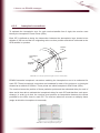
1
USER GUIDE FOR EGNOS APPLICATION DEVELOPERS ED 2.0, 15/12/2011 Preface After more than 10 years of development and qualification efforts bringing together actors from across the European continent, including project teams, industrial teams, and operators, for the first time Europe has at its disposal a GNSS infrastructure which delivers, on a permanent basis and according to international civil aviation standards, a satellite navigation service covering much of the continent. For all space sector participants, it is extremely gratifying to see a programme having originated in research and development leaving the space agency sphere and entering into the world of services addressed at a vast community of users. After telecommunications, meteorology, oceanography, search and rescue and Earth observation, we are now seeing the emergence of a new area of operational space activity, which clearly illustrates the unique and essential contribution space can make to citizens. The success of a development activity is a crucial step on the way to the success of a programme. For it to become a total success, efforts must now focus on ensuring that users, in all application areas, can obtain easy access to services, making those services straightforward to use and, of course, on guaranteeing quality of service over time. This guide is designed to acquaint the user with the system and to provide the essential technical information that users and application developers require if they are to make the best possible use of EGNOS. CNES, the European Space Agency and the European Commission are proud to have contributed to the development of the EGNOS system, and thank all participants in this effort, both public and industrial, for their contributions to and support for the programme. They also wish every success to the EGNOS operational exploitation phase and hope that this guide will allow users from all walks of life to make use of EGNOS in a great many application areas. Yannick d’Escatha President Centre National d’Etudes Spatiales Matthias Ruete Director-General DG Energy and Transport European Commission Jean-Jacques Dordain Director General European Space Agency DISCLAIMER This guide is designed to be used by developers of applications for the European satellite navigation system EGNOS. Under no circumstances must it be taken to be a manual certified by the designers and developers of the EGNOS system, or by any legal and regulatory authorities. The information it contains shall be no substitute for official EGNOS-linked documents and shall be considered information provided «as is», with no guarantee of any kind, explicit or implicit, notably in respect of its accuracy, reliability, exhaustiveness, appropriateness for and adaptation to a specific use or the needs expressed by the users of this guide. It implies no obligation on the part of the European Commission, CNES and ESA. In no sense does the EGNOS guide exempt users from their obligation to exercise prudence in its application and in the interpretation they make of it in the performance of their activities, whatever those may be. Consequently, its use and implementation is under the exclusive responsibility of its users, while the European Commission, CNES and ESA can under no circumstances be held liable for damages of any kind, whether caused by the implementation, use or interpretation of the information contained in the EGNOS guide. Furthermore, the European Commission, CNES and ESA may make any changes to this guide they deem to be useful, notably following any future evolutions of the EGNOS system. 0 INTRODUCTION EGNOS (the European Geostationary Navigation Overlay Service) is designed to complement the American GPS system. It comprises a number of navigation payloads on board satellites in geostationary orbit and a ground-based network consisting of a series of monitoring stations and several control centres. The EGNOS system has been operational since 1 October 2009 for non-sensitive uses that do not jeopardise human life. The EGNOS Safety-of-Life (SoL) service, which can guide aircraft on their approach flight path, was opened on 2 March 2011. Most commercially available GPS receivers currently receive and use EGNOS signals, thus permitting the implementation of a a great number of applications or various types of experiments. The purpose of this guide is to provide practical information to EGNOS users (SMEs, scientific laboratories, application developers, etc.) who are not specialists in the use of the system. It therefore is addressed primarily at those outside the aviation community, which has been involved in the development of EGNOS from the outset and is familiar with its use. It aims to answer questions such as “How can EGNOS enhance my application?”, “How, in practice, can I use EGNOS signals and messages?”, etc. It then explains how you obtain the latest up-to-date information on EGNOS and on evolutions of the system, and gives advice on how to choose a receiver that makes best use of EGNOS functionalities. Finally, some specific examples of applications are provided which serve to illustrate its use. 7 1 1.1 WHY DO WE NEED EGNOS ? SATELLITE NAVIGATION SYTEMS FROM TRANSIT TO GALILEO The USSR could never have imagined when launching the satellite Sputnik in 1957 that in doing so it would be giving the USA the idea for GPS. But the US Department of Defense (DoD) had noticed that by using measurements of the Doppler effect of signals emitted by Sputnik, it was possible to plot one’s position on Earth provided that one knew the satellite’s orbital parameters. Armed with this discovery, in 1958 the US began its first satellite navigation programme, named TRANSIT. This system, which went into operation in 1964, made use of the Doppler effect to establish a position to within an accuracy of 200 to 500 metres, but it had a number of disadvantages: with only 6 satellites, positioning was not possible at any point on the globe 24 hours a day, and in some cases it took up to 24 hours to establish a position. To overcome these disadvantages, the US military began thinking about how to create a more effective system that would make it possible to establish one’s position, speed as well as the time with great accuracy, 24 hours a day at any point on the globe. Its research gave rise to the current GPS system, or to go by its full name NAVSTAR GPS (short for NAVigation System with Time And Ranging Global Positioning System). The first prototype GPS satellite was launched in 1978 and the system was declared operational in 1995 with 24 satellites in orbit. GPS offered two services, the first of which was called “precise positioning service” only accessible to the US armed forces (and to their allies) and the second which was called “standard positioning service” or “open service” with a degraded performance level accessible to all civil users without restriction. Today in 2011, GPS is still operational with some 30 satellites currently in orbit. A new generation of satellites is currently being developed (Block III) with a view to further improving the system’s performance. In the 1980s, during the Cold War, the Soviet military, aware of the strategic importance of possessing a satellite navigation system, came up with its own answer to the GPS system in the shape of GLONASS, short for GLobal’naya NAvigatsionnaya Sputnikovaya Sistema, a system with similar objectives and performance to GPS offering a means of precisely determining ones position anywhere on the planet. GLONASS was declared operational in 1996. But after some ups and downs due to technical problems and a lack of funding in the wake of the Cold War, the GLONASS system went into stagnation and, with no more than 6 operational satellites, was unable to offer any real availability. In 2002, the Russian Federation decided to relaunch the programme and is now studying a new generation of satellites with a view to having a fully operational system by 2015. In 2011, the GLONASS system is approaching its nominal configuration. 9 1 Why do we need EGNOS? Europe, in turn, aware of the strategic importance of satellite positioning systems for its economy and independence, decided to develop a satellite navigation system of its own, under civil control, and began the first studies to that end in 1994. The system, called Galileo, will offer a range of services which will be compatible and directly interoperable with the GPS open service. The first experimental satellites GIOVE-A and GIOVE-B have been launched in 2005 and 2008, followed in October 2011 by the first two satellites of the IOV phase. Finally, China, with Beidou, has begun implementing a regional satellite navigation system, having launched the system’s first satellites in 2000. Extension of that regional system to form a global system named Compass is ongoing since 2010. By allowing anyone with a GPS receiver to determine their position to within a few metres, their speed to within a few cm/s, and the time to within a few hundredths of a microsecond around the clock and across the entire globe, GPS has revolutionised the world of navigation and has opened the way for new applications based on navigation, positioning and time determination. Today, the use of satellite navigation systems (grouped under the term GNSS, for Global Navigation Satellite System) has become essential to a multitude of applications, whether they be strategic, professional or simply leisure-oriented. In 2011, the GPS system is the only fully operational global satellite navigation system. 1.2 GPS: HOW IT WORKS, ITS PERFORMANCE AND LIMITATIONS This section gives some information on how the GPS system works, as well as on its performance and limitations. Refer to Annex 3 for more information on GPS. 1.2.1 How GPS works The basic principle underpinning satellite positioning is the use of distance measurements at a precise moment in time T between a receiver and several satellites whose exact positions in space are known. Pseudoranges The satellites emit electromagnetic waves which are propagated through space at the speed of light. It is then possible to calculate the distance separating the satellite from the receiver by determining the time a wave takes to travel from satellite to receiver using the following formula: d = c*t, where d is the distance, c the speed of light and t the time it takes for the wave to travel from satellite to receiver. 10 1 Why do we need EGNOS? To estimate the time that signals take to travel between a given satellite and the receiver, the receiver compares a unique code linked to the satellite’s navigation signal with a copy of the same code generated by the receiver itself. Since the time interval between the codes corresponds to the transit time, this can then be used to calculate the distance, or “pseudorange”. The use of “pseudo” in this term is because this distance does not correspond to the geometric distance between satellite and receiver due to the bias between the time reference used by the GPS system and that used by the receiver (as explained below). With at least three distance measurements to three different satellites it is theoretically possible to determine the position of the receiver if and only if the receiver’s clock is perfectly synchronised with those on board the satellites. Unfortunately, though all the satellites may be equipped with perfectly synchronised atomic clocks, the same is not true for receivers, which for reasons of cost and compactness are equipped with internal clocks that are not synchronised with the satellite clocks and whose stability is very poor compared with those aboard the satellites. The following table illustrates the performance in terms of stability of various clock or oscillator types: Daily time difference Quartz watch Temperature-controlled quartz oscillator (as used in GPS receivers) Thermostatted quartz oscillator Ultra-stable oscillator Equivalent in terms of distance accuracy One second 300 000 km 10 milliseconds 3 000 km 0.1 millisecond (10-4s) Several microseconds (10-6s) Atomic clock (as used on GPS or Ten nanoseconds (10-8s) Galileo satellites) Atomic clock from ACES/PHARAO Ten picoseconds (10-11s) scientific project 30 km 300 m 3m 3 mm Since a 1 millisecond difference between a satellite clock and receiver clock can produce a 300 km positioning error, this clock bias must be compensated for. That is why distance measurements are made to a fourth satellite in order to calculate the bias. To sum up, this method entails solving the system of four equations with four unknowns as follows: PRi = ( X i − X u )2 + (Yi − Yu )2 + (Z i − Z u )2 + c ⋅ bu where i = 1 to 4 Where Xi, Yi, Zi represent the coordinates for the positions of each of the four satellites, PRi represents the pseudoranges measured for each of the four satellites, bu is the clock bias between the receiver and the satellites, c is the speed of light, Xu, Yu et Zu represent the coordinates to be calculated of the receiver’s position. 11 1 Why do we need EGNOS? Satellite positions and clocks Each satellite transmits a constant stream of information in the form of a navigation message which can be used to precisely determine its position in space at a given time T. This information is known as almanac and ephemeris data. Almanac data consist of parameters which allow a medium-term estimate to be made of the position of all the satellites as a function of the time. They are used during the acquisition phase to identify those satellites that are visible. Ephemeris data consist of a set of parameters describing very accurately the orbit of a satellite as a function of the time, making it possible to calculate the satellite’s position at a precise moment t to within about 1 metre. The navigation message also includes data which can be used to correct certain errors such as clock corrections for the satellites. How the receiver calculates its position Using pseudoranges, the satellites’ orbital parameters and error correction, a receiver can calculate a position to within several metres, generally expressed in longitude, latitude and altitude in accordance with WGS84 (the World Geodetic System 1984 reference system). Sources of error and how they affect positioning Various errors interfere with pseudorange measurements. It is not possible to know exactly what these errors are but their distributions can be characterised statistically. It so happens that errors that adversely affect GPS system accuracy follow distributions that closely mirror Gaussian distributions. One characteristic of these distributions is that 95% of the population is situated in the band [-2σ ; 2σ], where σ represents the typical deviation of the distribution around the mean. In practice, therefore, the errors E affecting pseudorange measurements are often expressed as 2 σ, which means that the probability of the real error being less than E is 95%. Given that the notion of error is directly linked to that of accuracy, and that each of the error components contributes to the calculation of the position or time, the positioning accuracy is also expressed at 95%. For a description of the different error types, see Annex 2, which provides the principal GPS errors. Using the various error components, one can determine a UERE (User Equivalent Range Error), which provides the accuracy of the pseudorange measurement between the user and each satellite. 12 1 Why do we need EGNOS? 1.2.2 Performance The performance of a satellite navigation system is expressed according to four criteria: accuracy, integrity, continuity and availability. •Accuracy corresponds to the difference between the measured and the real position, speed or time value. •Integrity refers to the confidence the user is able to have in the calculation of the position. Integrity includes a system’s capacity to provide confidence thresholds as well as alarms in the event that anomalies occur. •Continuity defines a system’s ability to function without interruption throughout the operation the user wants to carry out (for example landing a plane). Continuity is the probability, from the moment that the accuracy and integrity criteria are fulfilled at the beginning of an operation, that they continue to be fulfilled throughout that operation’s entire duration. •Availability is the percentage of time in which, over a certain zone geographical area, the accuracy integrity and continuity criteria are fulfilled. Note: the notion of integrity is also used in computing, where it has a different sense (in computing it is defined as the property of a piece of numerical data having undergone no alteration during its storage or transfer). 1.2.3 Limitations 1.2.3.1 Accuracy The accuracy of the GPS system has improved continually over the last few years. Nonetheless, the accuracy which can be expected today remains in the order of several metres, which can prove inadequate for certain applications. Vertical positioning, in particular, constitutes the main limitation in terms of accuracy. The GPS system accuracy specifications provided by the US Department of Defense (see Annex 2, [DR1]) are given in the following table (divided into horizontal, vertical and temporal positioning service). 13 1 Why do we need EGNOS? GPS Specifications Real expected performance Horizontal service Accuracy ≤ 17 metres (95%), available for 99% of the time or more 7.1 m Vertical service Accuracy ≤ 37 metres (95%), available for 99% of the time or more 13.2 m Temporal service Accuracy ≤ 40 ns (95%) 12 ns See also information in the Annexes. 1.2.3.2 Integrity Currently, the GPS system does not make it possible to guarantee the position for some demanding applications, such as airport approaches by aircrafts. In particular: •The probability of loss of integrity of a GPS satellite is far greater than that which is required for the purposes of navigating an aircraft; •In the event of system breakdown or malfunction (clock drift, broadcasting of erroneous data, etc.), pseudorange measurement can be biased by anything from a few metres to a few kilometres. Due to the system architecture, and specifically the limited number of GPS ground stations, these errors may impact the user for several hours (6 hours maximum). GPS system errors or breakdown can also have serious repercussions for user safety if not detected in time and have the effect of restricting the number of possible applications. In particular, they make the system unsuitable for critical applications such as civil aviation, or those with regulatory or legal ramifications such as transaction timing, automatic billing, etc. It is with a view to overcoming the limitations of GPS with respect to integrity, therefore, that augmentation systems have been developed. 1.3 AUGMENTATION SYSTEMS The ease of use and round-the-clock availability at any point on the globe of GPS, combined with its unrivalled intrinsic performance, have led many users to want to use GPS for specific applications for which it was not initially designed. 14 1 Why do we need EGNOS? Among such applications are those for which a high degree of integrity is required (aircraft landing, command and control systems for trains, etc.) or those for which accuracy to within a metre or below is necessary (geodesy, ship docking, etc). To respond to such user demand, it was necessary to implement systems to complement GPS which could compensate for certain inadequacies or improve its performance while at the same time continuing to benefit from the technological and operational advancement offered by GPS. These complementary systems, known as augmentation systems, are either made up of ground-based or space-based infrastructures, or otherwise they implement specific techniques at receiver level. 1.3.1 Ground-based augmentation systems 1.3.1.1 DGPS (Differential GPS) DGPS or differential GPS is a real-time positioning method which uses fixed reference stations to transmit information to users within the coverage area so as to enable a receiver to correct certain errors in relation to the satellites’ pseudoranges. All error types can be handled except for local errors generated by the user receiver (multipath errors inherent to the receiver environment, measurement noise). The accuracy achieved depends directly on the distance between the reference station and the user, and deteriorates sharply beyond 100 to 150 km. Each station constantly calculates its GPS position and compares it with its real position, deducting from that applicable correction parameters known as differential corrections, which it transmits by terrestrial radio to receivers located in the coverage area. In addition to the ground-based infrastructure, use of this system requires users to be equipped with a data link system able to receive the messages emitted by the reference stations. A transmission rate of 100 bits/s and a refresh rate of 10s are usually sufficient for most applications. In the case of DGPS for maritime applications, the RTCM SC-104 standard is generally used to transmit the differential corrections that make it possible to obtain accuracy to within a metre using a single-frequency receiver. 15 1 Why do we need EGNOS? GPS SATELLITE GPS PSEUDO RANGE CORRECTIONS GPS DATA LINK DATA LINK CORRECTIONS PROCESSOR MOBILE STATION REFERENCE STATION Figure 1: How DGPS works Depending on the applications, the reference stations can be independent or networked. They can also be either fixed or movable. 1.3.1.2 GBAS (Ground Based Augmentation System) GBAS is a local augmentation system to GNSS standardised by ICAO (International Civil Aviation Organization) for precision approach and landing operations, with a high level of integrity. Its principle is similar to that ofs DGPS. GBAS is made up of a ground subsystem comprising two to four GNSS reference receivers and an airborne subsystem. Using data from reference receivers, the ground-based subsystem calculates corrections to the pseudoranges for all visible satellites. The ground subsystem also monitors the quality of the information transmitted to the airborne subsystem by performing a large number of tests on the differential corrections and pseudoranges. These corrections are transmitted to the aircraft using the VDB (VHF Data Broadcast) system. A GBAS system provides its services to all aircraft present in its coverage area of up to 20 Nautical Miles at the minimum. GBAS is designed to respond to the problems posed by the most demanding of operations (all-weather precision approach). The civil aviation community is currently working towards standardising GBAS for category II and III precision approach, which is likely to be operational as of 2015-2020. 16 1 Why do we need EGNOS? 1.3.1.3 Other ground-based augmentation systems RTK (Real-Time Kinematic) This technique is based on a principle similar to that of DGPS with a single reference station and a means of communication between the receiver and the station, but in this case it is not corrections that are transmitted but raw data. These raw data then enable specialised receivers to calculate the satellite-to-receiver transit time based on the phase of the wave received and not on the code sequence. This method, which requires more complex receivers, makes it possible to achieve accuracy of roughly 3 to 5 cm, conditional upon being within a distance of up to 100km from the reference station. It also takes considerable time to initialise and requires dual-frequency receivers. A variant of this method known as interpolated RTK makes it possible to achieve even greater accuracy by using a denser network of reference stations (in France, for example the Teria, Orpheon and Sat-Info networks). In this case, the errors in the receiver measurements are interpolated with measurements carried out by the stations situated around the user. PPP (Precise Point Positioning) The Precise Point Positioning method (PPP) is a different approach which makes use of undifferentiated code and phase observations from a single or dual-frequency receiver. This method is principally used in deferred time since it requires correction data to be received. PPP uses these precise orbital data and clock corrections to calculate an extremely accurate absolute position (static or kinematic) to the decimetre or even centimetre in kinematic mode using precise IGS products, available with 3 weeks delay. Unlike with RTK, common errors (the effect of tides or ocean loading, for example) are not eliminated. Obtaining a position that is both absolute (that is, not relative to a reference station) and extremely accurate makes it possible to observe phenomena such as Earth tides or crustal deformation under the influence of ocean loading. Some commercial service providers (Omnistar, Starfire, Veripos, etc.), referred as GSBAS (Global Satellite Based Augmentation System) offer commercial real-time correction products, broadcast via geostationary satellites, carried out thanks to a global sensor stations network. The claimed optimal precision is decimetric. 1.3.2 Receiver-level technologies : RAIM RAIM (Receiver Autonomous Integrity Monitoring) is an algorithmic technology for improving integrity based on the use at receiver level of redundancy of the available GNSS pseudoranges, allowing comparison between the positions established by different groups of four satellites within visual range. 17 1 Why do we need EGNOS? RAIM can function in two ways. The first consists in detecting a ‘unhealthy’ (faulty) satellite (Fault Detection – FD) while the second detects and then excludes the unhealthy satellite from the positioning calculation made by the receiver, thus allowing the user to continue working (Fault Detection and Exclusion – FDE). Certain RAIM algorithms can also use the speed and acceleration information provided by platform sensors (for example, accelerometers, altimeters, odometers, speed sensors, etc.), thereby improving their performance. RAIM is generally used on commercial aircraft GPS receivers to provide autonomous monitoring of GPS signals. A variant of the principle used for RAIM algorithms is AAIM (Aircraft Autonomous Integrity Monitoring), which is used in the aviation field but is equally applicable to other modes of transport. AAIM uses data generated through coupling with an inertial navigation system (INS) and takes advantage of INS-GPS complementarity. Though INS provides short-term error stability, inertial drift increases over time, while GNSS errors are limited temporally. GNSS and INS are therefore highly complementary, with GNSS serving to recalibrate INS, which in turn detects shortterm anomalies with GNSS. RAIM and AAIM are also known by the term ABAS (Aircraft Based Augmentation System). 1.3.3 Space-based augmentation systems Well before the operational deployment of GPS, research work was being conducted with the aim of improving the GPS signal using space-based augmentation, notably from the 80s onwards at the instigation of CNES and the DGAC (Civil Aviation Authority) in France. These were the beginnings of EGNOS, notably with the CE-GPS (European Complement to GPS) experiments. But it was really from October 1994, when the US government offered civil aviation the possibility of using GPS free of charge (the Russians did the same with GLONASS in June 1996) that large-scale work got under way. It was then that ICAO (International Civil Aviation Organization) began studies on complementary systems to compensate for certain disadvantages of GNSS in terms of accuracy (essentially in the vertical, a phenomenon which at that time was made worse by the deliberate degradation applied to GPS until 2000), integrity, continuity of service and availability. Indeed, neither GPS nor GLONASS meet ICAO operational requirements in respect of the most critical phases in aircraft flight (in particular landing). This work gave rise to the SBAS (Satellite Based Augmentation System) concept and the beginnings of the process of standardisation carried out by ICAO. 18 1 Why do we need EGNOS? The SBAS concept is based on the transmission of differential corrections and integrity messages for navigation satellites which are within sight of a network of reference stations deployed across an entire continent. A key characteristic of SBAS is that the data link frequency band and signal modulation are identical to those of GPS signals. In addition, the SBAS signal is broadcast by geostationary satellites able to cover vast areas, with each error source being isolated. Several countries and regions have implemented their own satellite-based augmentation system. For example, the North American SBAS component, WAAS (Wide Area Augmentation System), covers the continental United States (CONUS), Canada and Mexico. The Europeans, for their part, have EGNOS (the European Geostationary Navigation Overlay Service), which covers Europe’s “ECAC” area, while Japan is covered by MSAS (Multi-functional Satellite Augmentation System). Now, India and Russia have launched their own SBAS programme, respectively named GAGAN (GPS And GEO Augmented Navigation) and SDCM (System of Differentional Correction and Monitoring). Note: ECAC (the European Civil Aviation Conference) is an organisation of 44 Member States whose role is to promote intergovernmental cooperation on air transport matters in Europe. FIGURE 2: ECAC Member States 19 1 Why do we need EGNOS? All of these systems are interoperable and adhere to the RTCA aviation standards, MOPS DO229D, while at the same time having their own unique characteristics. RTCA is an organisation that issues standards for civil airborne equipment. MOPS 229D (Minimum Operational Performance Standards for Global Positioning System/Wide Area Augmentation System Airborne Equipment version D) describes the implementation of SBAS services for receivers in civil aviation use. An annex to DO229D contains the specifications for the SBAS signal and message. This document is available for a fee and can be obtained from the RTCA website at http://www.rtca.org. The RTCA provides regular updates to these standards. The various SBAS systems (WAAS, EGNOS, MSAS, GAGAN) were developed in accordance with this common standard and are therefore all compatible (in other words do not interfere with each other) and interoperable: a user with a standard receiver can benefit from the same level of service and performance whether located in the EGNOS or WAAS coverage area. Applications of SBAS Outside the civil aviation sphere, SBAS systems are used in all fields where accuracy and integrity are of foremost importance. In particular, SBAS is indispensable for all applications where people’s lives are at stake or for which some form of legal guarantee is required. SBAS makes it possible, for example, to improve and extend the scope of applications for GPS in areas such as precision farming, the guidance of agricultural machinery, on-road vehicle fleet management, oil exploration for the positioning of platforms out at sea or scientific applications such as geodesy, etc. The following figure illustrates the coverage areas of the various SBAS systems. SDCM WAAS MSAS EGNOS GAGAN FIGURE 3: Coverage areas of SBAS systems 20 1 Why do we need EGNOS? 1.4 EGNOS The European Geostationary Overlay Service (EGNOS) complements the American GPS system, which is made up of a number of navigation payloads aboard satellites in geostationary orbit, a ground-based network comprising a series of positioning stations and several control centres, all of which are interconnected. EGNOS, while dependent on GPS, is able to offer services today that are close to those that in future will be offered by Galileo: • by improving GPS positioning accuracy; •by providing the user with information on GPS reliability by sending “integrity messages” giving confidence thresholds and alarms in the event of anomalies; • by emitting a signal synchronised with Coordinated Universal Time (UTC). Three principal players have been behind the development of EGNOS: the European Union, represented by the European Commission, the European Space Agency (ESA) and Eurocontrol (European Organisation for the Safety of Air Navigation). The European Space Agency acted as system prime during the development, validation and initial exploitation phase until March 2009. Eurocontrol established the requirements called for by system users among the civil aviation community. The European Union contributes towards codifying the requirements of all its users and validating the system. It also takes care of the establishment of EGNOS by taking all the necessary measures, notably the leasing of the payloads for the geostationary satellites. The industrial prime contractor role for EGNOS has been given to France’s Thales Alenia Space. EGNOS funding up until the exploitation phase was provided by ESA in the context of its Artes 9 programme, by the EU through its TEN-T budgets and 5th and 6th R&D Framework Programmes, and by air navigation service providers (AENA (Spain), DFS (Germany), DSNA (France), ENAV (Italy), NATS (United Kingdom), Skyguide (Switzerland), and NAV-EP (Portugal). These service providers joined forces in 2001 to set up a European Economic Interest Grouping (EEIG), christened ESSP (European Satellite Services Provider), which allowed it to become EGNOS operator and to coordinate the activities of its members in providing operations and system maintenance tasks. ESSP, initially headquartered in Brussels, transferred to Toulouse in 2008, in doing so becoming ESSP SAS, a limited liability company under French law. 21 1 Why do we need EGNOS? In 2005, under contract from ESA, ESSP started the initial operation phase of EGNOS with a view to its qualification. In April 2009, system ownership was transferred to the European Commission, now in charge of the contracts for the exploitation and maintenance of the system, which is expected to have a nominal exploitation of at least 20 years. In July 2010, ESSP went through a process of certification to become an Air Navigation Service Provider, first step to declaration of Safety of Life service which has been awarded by European Commission in March 2011. 22 2 2.1 ADVANTAGES OF EGNOS ADVANTAGES OF EGNOS As stated above, as it currently stands, the EGNOS system enables users with an EGNOScompatible GPS receiver: • to improve positioning accuracy by a factor of two to three; •to have integrity data for validating the signals transmitted by GPS satellites: they have confidence thresholds regarding the calculated position and are alerted in near-real-time (less than 6 seconds) of any data reliability shortcomings; • to benefit from accurate and reliable synchronisation with UTC; • to improve availability. FIGURE 4: EGNOS functionality Note: to date, the functionality of providing additional pseudorange measurements from geostationary satellites has not been activated. 2.2 HOW TO USE EGNOS To benefit from the advantages provided by EGNOS, users need simply use an EGNOS-compatible GPS receiver. Thanks to the broadcasting of signals that are compatible and interoperable with GPS signals (with frequency and modulation identical to GPS), these receivers differ very little from standard GPS receivers and do not require a communications connection to reference stations. 23 2 Advantages of EGNOS Access to the EGNOS signal is, like the civil GPS signal, free of charge. Most commercially available receivers for professionals and the general public use the EGNOS signal. It is also possible to access EGNOS messages by means of other distribution channels available on the internet such as SISNeT and EDAS. These channels are presented in detail in section 4. 2.3 SERVICES TERMINOLOGY In the official literature, the services provided by EGNOS are often grouped together using the following terms: • Open Service (OS) refers to the use of accuracy improvement. •Safety-of-Life (SoL) refers to use of the integrity function. This service was originally intended for the world of safety-critical transport (aviation, shipping, railways, etc.) but is also suited to other applications such as those requiring legal guarantees. •Commercial Data Distribution Service (CDDS) refers to the use of additional data by certain professional users. This service is not provided by the EGNOS signal broadcast by the geostationary satellites but by the EDAS system (see section 4.2). 2.4 EGNOS PERFORMANCE LEVELS 2.4.1 Accuracy One of the main advantages of EGNOS is the improved accuracy in relation to a position solely calculated using GPS, by the broadcasting of differential corrections to GPS orbits, GPS clocks and the ionosphere. The horizontal accuracy provided is of the order of 1 to 3 metres, the vertical accuracy 2 to 4 metres (2σ, 95%), see diagram in section 7.1 . In addition, EGNOS was also designed to free users from the intentional degradation of the civil GPS signal by Selective Availability (SA), which has been deactivated since May 2000. 24 2 Advantages of EGNOS 2.4.2 Integrity The GPS system’s errors or malfunctions may, depending on the satellite geometry, have serious repercussions for user safety if not detected in time and restrict significantly the range of possible applications. Another important EGNOS differentiator is the integrity it delivers. Indeed, in contrast to GPS for which no guarantee is given, EGNOS broadcasts an integrity signal giving users the capacity to calculate a confidence interval, alerting them when a GPS satellite malfunctions and is not be used for an application where safety is a factor. The data produced and transmitted by EGNOS thus include estimates of GPS satellite orbit and clock errors and estimates of errors due to GPS signals crossing the ionosphere. These parameters enable users to evaluate a limit from its position error. Four parameters characterise integrity: • alarm limit; • protection level; • integrity risk; • Time To Alarm (TTA). If the positioning error exceeds the stated protection level, an alarm must be transmitted to the user. That alarm must be received by the user within the Time To Alarm limit. The probability of an alarm not being transmitted to the user within the time limit must be lower than the integrity risk. Users of a GNSS system wishing to obtain a certain degree of integrity must state their needs in line with these four parameters for a given application. EGNOS is specified to deliver the following integrity performance levels: Parameter Performance Level Integrity risk 2x10⁻⁷ per 150 seconds Time To Alarm 6s Vertical Alarm Limit 50 m Horizontal Alarm Limit 40 m 25 2 Advantages of EGNOS The required 6s Time To Alarm between the point when the problem impacts the user and the moment when the alarm is available at the user end is both a major and very design-critical component of the EGNOS system. In practice, since the actual position error is unknown to the user, estimates of these errors called “Protection Levels” (XPL, X designating the horizontal H or vertical V component) are compared to the alarm limits. A civil aviation approach procedure corresponding to an alarm level XAL will be authorised only if the XPL protection level is less than XAL. See also the presentation of the Stanford diagram in Annex 9, which can be used to measure integrity performance from a receiver in a known position. FIGURE 5: Integrity limits principle EGNOS has therefore been so designed to enable users to perform more critical operations and to provide them with XPL limiting the actual error with a probability factor of the order of 10-7. The XPLs can be calculated from certain data supplied by the EGNOS system and the geometry of the GPS satellites used. (See Annex 7). EGNOS broadcasts parameters which enable users to assess the degree of confidence they can have in the differential corrections and to estimate a limit to their positioning error. 26 2 Advantages of EGNOS 2.4.3 Synchronisation with UTC The EGNOS system uses a system time known as ENT (EGNOS Network Time), linked to UTC (Coordinated Universal Time), notably through the installation of an EGNOS ground station on the site of the Observatoire de Paris, which itself provides UTC reference time for France. All the differential corrections broadcast by EGNOS are referenced according to ENT. Thus, the time obtained by the user when he calculates his position using EGNOS data is also referenced in ENT, not in GPS time. In addition, EGNOS also broadcasts a specific message containing several parameters allowing the receiver to estimate a UTC. The user then has a precise, reliable time directly synchronised with UTC. Section 6.4 and Annex8 describe the way to link ENT time to UTC time. The accuracy obtained relative to UTC is less than 50 nanoseconds. Note: UTC (Coordinated Universal Time) represents a time scale which serves as international reference time. It is close to Universal Time, UT, directly linked to the Earth’s rotation and differs from International Atomic Time (TAI) by an integral number of seconds. 2.4.4 EGNOS Reference frame Though very close, EGNOS corrections are not directly referenced to GPS terrestrial reference frame (WGS84) but are periodically aligned on ITRF (International Terrestrial Time Frame) in order to provide a consistency of an order of a few centimetres.Therefore, this means that, for most applications, positions provided by an EGNOS receiver can be used in WGS84 frame, including GPS cartography databases. 2.5 COVERAGE Unlike the GPS system, which uses dedicated satellites on medium orbits at roughly 20,000 km altitude in 6 different orbital planes, the EGNOS system uses payloads on board 3 telecommunications satellites placed in geostationary orbit at an altitude of 36,000 km. Note: geostationary orbits are geosynchronous orbits (having a period of revolution identical to that of the Earth) in the equatorial plane, with the result that a satellite following that orbit always appears stationary relative to any point on the Earth’s surface. 27 2 Advantages of EGNOS As things stand in 2011, the EGNOS signal is broadcast by three geostationary satellites: two Inmarsat and ESA’s Artemis satellites, positioned above Africa and East of the Atlantic. These three satellites’ orbits are in the equatorial plane, at three different longitudes, with each able to broadcast EGNOS services across the whole ECAC area. Unlike the GPS and GLONASS satellites, these three space platforms carry no signal generators. They are fitted with a transponder which does nothing more than relay the signal processed on the ground and sent into space. As with GPS satellites, each EGNOS satellite is allocated a unique PRN (Pseudo-Random Noise) number, which allows it to be identified by the user. The NMEA standard, used in output mode by most commercially available receivers, allocates a unique identifier to each EGNOS satellite, as described in the table below. As a general rule, 2 satellites out of the 3 available are used operationally for the broadcasting of the EGNOS message, the 3rd being used for the purposes of maintenance, testing and validation. The table below describes the situation at the time of writing of this guide, but that situation is subject to constant change. The reader is therefore advised to go to the ESSP or ESA websites (see section 09 for the list of links from which to obtain operational situation pertaining to the EGNOS satellites). Satellite PRN ID(NMEA) Position ARTEMIS 124 37 21,5 E INMARSAT AOR-E 120 33 15,5 W INMARSAT IOR-W 126 39 25 E FIGURE 6: EGNOS satellite coverage It should be noted that geostationary satellites, due to being positioned in the equatorial plane, are vertically above a user located at the Equator. Therefore, the further a user travels towards 28 the poles (towards high latitudes), the more the satellite drops down towards the user’s horizon. When the satellite is too close to the horizon, it is no longer usable. As regards EGNOS, beyond latitude 75°, the service becomes barely usable. Sometimes it is necessary to calculate the elevation of the EGNOS geostationary satellites relative to one’s position to see whether they will be visible in the area intended for the use of the application. Annex 4 details the method for calculating the elevation of the geostationary satellites relative to one’s position. 29 3 EGNOS ARCHITECTURE EGNOS service provision requires the following steps: • Step 1 : Collection of measurements and data from the GPS satellites. • Step 2 : Calculation of differential corrections, estimation of residual errors and generation of EGNOS messages. • Step 3 : Transmission of EGNOS messages to users via the geostationary satellites. A data integrity verification process is conducted in parallel with these steps. EGNOS, like GPS, consists of three segments: a space segment, which comprises the payloads of the three satellites, a ground segment, which is composed of the terrestrial infrastructure, and a user segment, made up of all the receivers. EGNOS also includes a support segment consisting of the following two entities: •The Performance Assessment and Checkout Facility (PACF), which serves to coordinate operations and maintenance, and monitors the functioning of the system, •The Application Specific Qualification Facility (ASQF), which provides applications support and the user interface. The operational components are all interconnected via the EGNOS Wide Area Network (EWAN) and are designed to transmit data in near real time. FIGURE 7: EGNOS Infrastructure 31 3 EGNOS architecture 3.1 STEP 1: COLLECTING MEASUREMENTS AND DATA FROM THE GPS RIMS network To ensure optimum, continuous gathering and observing of measurements and data from the various visible GPS satellites and of ionospheric variations, a network of observing stations called Ranging and Integrity Monitoring Stations (RIMS) was set up, mainly in Europe. The RIMS gather data and transmit them at a rate of 1 Hertz to the computation centres or Central Processing Facilities (CPFs) for exploitation. There are three types of RIMS: •Type A RIMS supply raw measurements from visible EGNOS/GPS satellites. These data are used by the CPFs to calculate corrections and estimate confidence thresholds. •Type B RIMS also supply raw measurements from visible EGNOS/GPS satellites. These data are used by the CPFs to verify broadcast messages and guarantee EGNOS integrity. •Type C RIMS are given over to the detection of specific faults known as «evil waveforms» (a corrupted navigation signal waveform caused by an anomaly on board a GPS satellite). The EGNOS system comprises about 40 RIMS located mainly inside and around its service area. There are also a few RIMS in Canada, French Guiana and South Africa to improve orbit determination performance. 32 3 EGNOS architecture FIGURE 8: EGNOS SITES (Courtesy ESSP) in April 2011 3.2 STEP 2: CALCULATING DIFFERENTIAL CORRECT AND ESTIMATING RESIDUAL ERRORS Consolidation of data and calculation of corrections by means of CPFs and MCCs Data gathered by the RIMS are processed by the Central Processing Facilities (CPFs), which estimate the differential corrections and integrity information and generate the EGNOS messages. 33 3 EGNOS architecture FIGURE 9: How CPFs work For redundancy and maintenance purposes, there are five identical CPFs, distributed over four sites known as Mission Control Centres (MCCs). Two of the CPFs are at Langen (Germany), one is at Torrejón (Spain), another at Swanwick (United Kingdom) and the fifth at Ciampino (Italy). 3.3 STEP 3: TRANSMITTING THE EGNOS MESSAGES TO USERS VIA THE GEOSTATIONARY SATELLITES Satellite uplinking: NLES The Navigation Land Earth Stations (NLES) receive the EGNOS messages from the CPFs and transmit them to the geostationary satellites for broadcasting to users, ensuring synchronisation with the GPS signals. Two NLES (one active and one providing hot redundancy) are deployed for each geostationary satellite, making six NLES in total. Distributing data to users: the geostationary satellites EGNOS messages received by the three geostationary satellites are transmitted directly to users. The message sequences differ between the three satellites. 34 4 4.1 OTHER WAYS OF ACCESSING EGNOS SISNET (SIGNAL IN SPACE THROUGH THE INTERNET) SISNeT is a service offered by the European Space Agency (ESA), available on the internet, enabling EGNOS differential corrections and integrity information to be accessed in real time. It is a free service but users need to register with the European Space Agency. For details go to http://www.egnos-pro.esa.int/sisnet/uas.html. The service is normally used via mobile internet connections (GSM, GPRS, etc.). The messages sent are EGNOS messages. The service makes it possible to: •Receive EGNOS messages even when the receiver does not have the EGNOS function. However, it must be able to use the data transmitted by SISNeT, that is, integrate the differential corrections and integrity information; • Access EGNOS data in areas where the geostationary satellites are masked. Important: this system is available only if the receiver has internet access capability. Regarding coverage, all mobile telephony operators offer access to the internet in Europe. The SISNeT service is therefore accessible almost everywhere in Europe. Moreover there is an increasing number of wifi hotspots in towns and cities. SISNeT has been operational since May 2006. For further information, go to http://www.egnos-pro.esa.int/sisnet 35 4 Other ways of accessing EGNOS 4.2 EDAS (EGNOS DATA ACCESS SYSTEM) European Commission has put in place a system to make EGNOS data available: EDAS. This system allows to have access to data issued from EGNOS infrastructure. Main types of available data are the following: •GPS, GLONASS and EGNOS GEO raw data collected by RIMS stations network. • EGNOS augmentation messages, as received by a user via EGNOS geostationary satellites. • Coordinates of RIMS antenna phase centre. Details of this information and means to access it are described on GSA website on page: http://www.gsa.europa.eu/go/egnos/edas 36 5 5.1 EGNOS MESSAGES SIZE AND BIT RATE The EGNOS system transmits its messages over band L1 (1575.42 MHz) at a rate of 250 bits per second. It uses the same modulation as GPS, but at a transmission rate five times higher. The size of every message transmitted is 250 bits, which enables one message to be transmitted per second. 5.2 MESSAGE TYPES Several message types can be transmitted by the system; the various message types currently standardised are listed below. FIGURE 10: List of EGNOS messages 5.3 STRUCTURE OF MESSAGE TYPES All EGNOS message types can be broken down into the following structure: •The first 8 bits of each 250-bit message correspond to part of the preamble. The preamble is a unique 24-bit word (01010011 10011010 11000110), spread over three successive messages, which enables the initial part of the data to be synchronised (during the acquisition phase). 37 5 EGNOS messages • The next 6 bits identify the message type (0 to 63). •The subsequent 212 bits correspond to the useful data contained in the message – which are specific to the message type (see section 6). •The last 24 bits correspond to the parity bits, which ensure that the data were not corrupted during transmission (no bit error). FIGURE 11: Messages type structure 5.4 MESSAGE VALIDITY PERIOD The EGNOS system is designed to provide users with the most up-to-date integrity parameters and differential corrections. However, EGNOS allows for the possibility of a user not being able to receive all the messages due for example to an erroneous bit. In such a case, in order to guarantee system performance, certain users need to apply degradation models to the information supplied (for example, aircraft in precision-approach phase). FIGURE 12: Message validity principle 38 5 EGNOS messages Refresh and validity periods: For each message type transmitted, there is thus a maximum refresh period which must be taken into account by the system in the transmitted signal. A validity period is also defined; it must be applied by the user and can depend on the application. These intervals and periods are given in the table below. Types Data contained 0 Don’t use for safety applications 1 PRN mask 2 to 6, 24 UDREI 2 to 5, 24 Fast Corrections Refresh period(s) Validity period En Route, Terminal, NPA Precision Approach 6 60 60 120 note 2 600 600 6 18 12 Variable note 1 Variable note 1 Variable note 1 24, 25 Long Term Corrections 120 360 240 9 GEO Navigation Data 120 360 240 7 Fast Correction Degradation 120 360 240 10 Degradation Parameters 120 360 240 18 Ionospheric Grid Mask 1200 1200 26 Ionospheric Corrections 300 600 600 12 UTC Timing Data 300 86400 86400 17 Almanac Data 300 None None 27 Service Level 300 (if used) 86400 86400 300 note 2 Note 1: The value depends on the degradation factor for the fast corrections (for further information, refer to section 2.1.1.4.9 of MOPS [DR2]). Note 2: When the masks are modified (see sections 6.1 and 6.2), message type 1 or 18 must be repeated several times before the new mask can be used. This ensures that all users have received the new mask before it is applied. In addition, the EGNOS system also continuously monitors the correctness of the values broadcast throughout their validity period. The sequencing of the various broadcast message types takes account of constraints that are due to the validity periods and refresh periods of each message. This sequencing is not predictable (reaction of system algorithms to the internal and external environment) and differs from one geostationary satellite to another. 39 5 EGNOS messages Degradation models For some corrections, the user should apply degradation models between two refreshes and during the validity period. Degradation factors are provided by message type 10 for long-term and ionospheric corrections and by message type 7 for fast corrections (especially for UDRE degradation). For further information, refer to section A.4.5 of MOPS [DR2]). 5.5 TYPE 0 AND TYPE 0/2 MESSAGES 5.5.1 What purpose do they serve? Message type 0 (MT0 is transmitted by EGNOS for as long as the signal is uncertified by Civil Aviation, as this is the case with the test signal. The broadcasting of this message therefore means that information provided by the system does not have to be used for safety of life applications (for example, civil aviation). Since March 2011, EGNOS has been officially declared usable for Safety of Life Applications (SoL Service). MT0 message has therefore been removed from operational messages transmitted by EGNOS. Message type 0 content: During these test phases, the content of MT0 is nevertheless identical to that of MT2 and can therefore be used in the same way (i.e. fast corrections will be provided, the only difference being the message identifier). The message is therefore known as MT0/2. MT0 may also be transmitted when a major problem occurs and the entire system becomes unavailable. When that happens, the MT0 content is completely empty and EGNOS must not be used for any applications at all. 5.5.2 What impact does this have on my receiver? In the case of non-safety of life applications and in order to enable the utilisation of the data transmitted by EGNOS, most receivers can process the data contained in MT0/2. Where this is the case, you must simply make sure that MT0/2 processing is activated by default in the receiver or that it can be activated by the user; see section 11. 40 6 HOW TO USE EGNOS MESSAGES This section describes the main types of EGNOS message. A more detailed description of the messages can be found in MOPS [DR2], which is the official reference. 6.1 APPLYING THE PRN MASK Each GPS satellite, and each EGNOS satellite, has a unique pseudo-random noise (PRN) code, which makes it identifiable by the user. Message type 1 (MT1) contains what is known as «PRN mask» data. This mask enables the size of EGNOS messages to be optimised by showing to which satellites (PRN) the data contained in the other, subsequent messages are related. The mask contains 51 bits. An nth bit at 1 shows that the nth satellite is being monitored by EGNOS. Bit mask Satellite PRN 1-37 GPS PRN constellation 38-61 Glonass slot number plus 37 62-119 Future constellations 120-138 GEO/SBAS PRN 139-210 Future constellations In the example below, the PRN mask shows that EGNOS will supply (in its subsequent messages) corrections and integrity information for the GPS satellites whose PRN codes are 3, 5 and 7. The first correction supplied by EGNOS will correspond to PRN3, the second to PRN5, and so on. 41 6 How to use EGNOS messages Bit N° 1 2 3 4 5 6 7 PRN Mask 0 0 1 0 1 0 1 PRN Code N° GPS PRN 3 GPS PRN 5 ... GPS PRN 7 FIGURE 13: PRN mask 6.2 USING DIFFERENTIAL CORRECTIONS 6.2.1 General information on differential corrections A short explanation is required here on what is done by EGNOS on the corrections, and what needs to be processed at application and/or receiver level. Thus: •In the case of the ionospheric correction parameters, the user must choose either to use the GPS’s Klobuchar parameters or to apply the parameters from the ionospheric grid transmitted by EGNOS (which is far more accurate). •For the other parameters – ephemeris corrections and/or clock corrections, Timing Group Delay (TGD) correction – GPS corrections must be applied first, and then the EGNOS corrections. 6.2.2. Issue of Data (IOD) IODs are attributes of masks and of current long-term and fast corrections. They are therefore set inside the concerned messages and enable the various data transmitted as well as the successive updates to be handled in a coherent manner. • IODP (Issue of Data PRN) identifies the current PRN mask. •IODFj = IOD Fast Corrections identifies current fast corrections (j refers to the type of message (2 to 5)). • IODE = IOD Ephemeris identifies current long-term corrections. • IODI = IOD Ionosphere identifies current ionospheric corrections. 42 6 How to use EGNOS messages 6.2.3. Ionospheric corrections To estimate the ionospheric error for each receiver/satellite line of sight, the receiver must identify the Ionospheric Pierce Points (IPPs). Each IPP is defined as being the intersection between the atmospheric layer located at an altitude of 350 km and the line originating at the receiver position and which is directed at the GPS satellite in question. Direction To SV Pierce Point Φpp, λpp Local tangent plane IGP : Ionospheric Grid Point User Φu, λu Earth Ellipsoid E hi Ψpp Re Earth Centre Ionosphere FIGURE 14: Principle of the Ionospheric Pierce Point (IPP) EGNOS transmits ionospheric corrections enabling the ionospheric error to be estimated for each IPP. These ionospheric corrections are broadcast for each of the points on a virtual grid situated at an altitude of 350 km. These points are called Ionospheric Grid Points (IGPs). The receiver knows the position of these particular points and the estimated delay for each of them and is thus able to estimate the ionospheric delay for each IPP and therefore each pseudorange. In order to do that, the receiver must perform an interpolation between the values provided for the IGPs close to each IPP. The receiver takes into account an obliquity factor (angle at which the ionosphere is traversed). FIGURE 15: IPP interpolation principle 43 6 How to use EGNOS messages The IGP grid consists of 11 bands numbered 0 to 10 (Mercator projection). Bands 0 to 8 are vertical, and bands 9 and 10 are defined horizontally around the poles, there being a total of 1808 IGPs. The following figure shows bands 0 to 8: N85 N75 N65 N55 S55 S65 S75 S85 Band 0 W140 Band 2 W100 Band 4 W60 W20 Band 6 E20 E60 Band 8 E100 E140 FIGURE 16: IGP grid In each of the bands 0 to 8, the IGPs are numbered 1 to 201, as shown below: North West 28 51 78 101 128 151 178 201 27 50 77 100 127 150 177 151 .. .. .. .. .. .. .. .. .. .. .. .. .. .. .. .. .. .. .. .. .. .. .. .. 2 30 53 80 103 130 153 180 1 29 52 79 102 129 152 179 East South FIGURE 17: IGP numbering principle In bands 9 (North Pole) and 10 (South Pole), the IGPs are numbered 1 to 192 from West to East and by increasing latitude. 44 6 How to use EGNOS messages In theory, EGNOS transmits data only for IGP marked in black or blue in the figure below. In practical terms, only IGP marked in blue are monitored on a regular way. FIGURE 18 : EGNOS IGP Masks 6.2.3.1 Message type 18: IGP mask Again with the aim of optimising message size, the mask principle is applied once again to associate ionospheric corrections with the IGPs to which they relate. Each message contains the mask for one band. A bit positioned at 1 means that the information is provided for the corresponding IGP. 6.2.3.2 Message type 26: ionospheric corrections Type 26 messages provide, for the IGPs present in the mask, data for computing the ionospheric corrections or Grid Ionospheric Vertical Delay (GIVD) and a parameter for estimating the accuracy of corrections (σ2GIVE), called a GIVE indicator (GIVEi). This information can be provided for a maximum of 15 IGPs per message. As the ionospheric bands can contain up to 201 IGPs, the IGPs present in the mask are grouped into blocks of 15 IGPs. Thus, block 0 contains data for the first 15 IGPs activated in the mask and so on. The σ2GIVE values are obtained through correspondence with the GIVE indicators transmitted in the message: 45 6 How to use EGNOS messages GIVEi 0 1 2 3 4 5 6 7 8 9 10 11 12 13 14 15 σ2give (m2) 0.0084 0.0333 0.0749 0.1331 02079 0.2994 0.4075 0.5322 0.6735 0.8315 1.1974 1.8709 3.3260 20.7870 187.0826 Not Monitored IGP Status Use Use Use Use Use Use Use Use Use Use Use Use Use Use Use Not Monitored On the basis of GIVD and σGIVE2 data provided for each GPS satellite in sight, and by applying an obliquity factor calculated from the elevation of the corresponding satellite (user’s view), the receiver obtains a slant range correction and a standard deviation value for the residual ionospheric error (written σUIRE2). Note: An EGNOS receiver will usually automatically calculate ionospheric corrections; for details of the calculations to be done, refer to Annex 6. 6.2.4 Long-term corrections Long-term corrections are broadcast by EGNOS to correct long-term variations in the ephemeris errors (orbit parameters: δx,δy and δz ) and clock errors (δaf0) of the GPS satellites. These corrections are provided in type 25 messages (long-term satellite error corrections). FIGURE 19: Format of MT25 (long-term corrections) 46 6 How to use EGNOS messages 6.2.5 Fast corrections Fast corrections are broadcast by EGNOS to correct rapid variations in the ephemeris errors and clock errors of the GPS satellites. These corrections are provided in type 2 to 5 messages. Message type 2 contains the data for the first 13 satellites of the mask that have the same IODP (Issue Of Data PRN) value. Message type 3 contains data on satellites 14 to 26 of the mask that have the same IODP value and so on. If the number of satellites in the mask (or in the remaining part of the mask) is less than 6, type 2 to 5 messages can be replaced by a message type 24. The structure of type 2 to 5 messages is as follows: FIGURE 20: Format of MT2 to 5 (fast corrections) Type 2, 3, 4 and 5 messages also contain a parameter enabling the accuracy of corrections to be estimated, known as UDRE (or rather UDRE indicators: UDREi). UDREi 0 1 2 3 4 5 6 7 8 9 10 11 12 13 14 15 σ2udre (m2) 0.0520 0.0924 0.1444 0.2830 0.4678 0.8315 1.2992 1.8709 2.5465 3.3260 5.1968 20.7870 230.9661 2078.695 N/A N/A Status of satellite OK OK OK OK OK OK OK OK OK OK OK OK OK OK Not Monitored (NM) Do not Use (DU) 47 6 How to use EGNOS messages 6.2.6 Message type 24: a special case Message type 24 contains two types of correction (fast and long-term), as well as the associated integrity parameters (UDREi). Message type 24 can be broadcast if the number of satellites in the last mask is less than 6. The first part of the message will contain the fast corrections and the UDREis, while the second will contain the long-term corrections. 6.3 USING INTEGRITY INFORMATION 6.3.1 Generation of alerts and protection levels Satellite Alarms EGNOS transmits, for each GPS satellite being monitored, an integrity signal with three values showing whether: • the status of the satellite is in keeping with use for a safety of life application (OK), • an anomaly has been detected with the satellite (Do not Use - DU) • the data on the satellite are insufficient to monitor it (Not Monitored - NM). The system has 6 seconds in which to inform the user of any integrity fault, that is, no more than 6 seconds may elapse between the moment when the problem impacts the user and the moment when the alert is available to the user. The alert is repeated in the signal for 4 consecutive seconds in order to counteract any message loss. Anomaly information («Do not Use» and «Not Monitored») is transmitted within UDRE parameters (values 14 and 15); see section 6.2.5. Ionosphere alerts EGNOS also transmits for each IGP being monitored an integrity signal with three values and showing its status if an anomaly is detected or if it is not being monitored. However, the «Do not Use» alert is generated through the maximum value of the GIVD ionospheric delay, not by a particular GIVE value. As with the satellite alerts, the system has 6 seconds in which to inform the user of any integrity fault. Again, the alert is repeated 4 times. 48 6 How to use EGNOS messages Protection levels The parameters transmitted to estimate the accuracy of the corrections (GIVE and GIVD) enable the receiver to compute horizontal and vertical protection levels (see section 2.4.2). Generally, only receivers used for aviation purposes calculate and automatically generate protection levels. However, the entire set of parameters needed to calculate them is broadcast, in particular through type 2 to 5, 6, 24, 18 and 26 messages (for details on the calculations to be done, refer to Annex 7. 6.3.2. Message type 6: a special case Type 6 messages are used in two instances: • to refresh UDRE indicators (UDREi) • to be able to broadcast satellite alerts very quickly if necessary (DU). It should be pointed out that although UDREi are contained in messages 2 to 5 with the fast differential corrections, their validity period may require more frequent updating. Similarly, if broadcasting of an alert cannot wait until the next type 2, 3, 4 or 5 message is broadcast, a message type 6 will be broadcast immediately. A message type 6 contains integrity information on all the mask’s satellites (the maximum number of satellites in the PRN mask is 51). Such messages also contain Issue Of Data Fast Correction (IODF) data, which associate UDREi values with the corrections contained in the type 2 to 5 and 24 messages (type 6 messages are not directly linked to the mask). FIGURE 21: MT6 format 49 6.4 USING TIME DATA The EGNOS system transmits via message type 12 the parameters for synchronising EGNOS Network Time (ENT), obtained during computation of the user’s position, with Coordinated Universal Time (UTC). MT12 is updated a maximum of every 300 seconds. Note: Although all the parameters needed to calculate UTC are broadcast in the message type 12, few receivers compute and automatically generate UTC from ENT. For details on the calculations to be done, refer to Annex 8. 6.5 GEO RANGING Messages Type 9 and 17 aim at providing information about GEO satellites navigation. They indeed provide respectively ephemeris and almanac positions for these satellites. MT 17 contains the almanac for up to three GEO satellites, as well as Health and Status, mainly required for acquisition purposes. More information is available in MOPS Section A.4.4.12. MT9 provide GEO ephemeris needed for the use of the GEO as a ranging source. In addition, a URA (User Range Accuracy), as defined for GPS satellites, is also provided. Details can be obtained in MOPS Section A.4.4.11. Though data are actually included in these messages, GEO ranging service is currently disabled on EGNOS (Ranging Off). 50 7 7.1 COMPARISON OF GPS AND EGNOS PERFORMANCE P ACCURACY Improvements brought by EGNOS to the various GPS error components (and thus to final accuracy for the user) are shown in the following table: Error type GPS EGNOS Orbit and clock synchronisation 1m 0.5 m 0.25 m 0.25 m 2m 0.3 m Receiver noise 0.5 m 0.5 m Multipath 0.2 m 0.2 m UERE (quadratic sum of errors - 1 σ) 2.31 m 0.83 m 1.1 1.1 Horizontal positioning accuracy error (1 σ) = UERE x HDOP 2.54 m 0.92 m Horizontal positioning accuracy error (2 σ, 95 %) 5.08 m 1.84 m Tropospheric error Ionosphéric error HDOP (function of geometry of visible satellites) TABLE 1: Summary of GPS-EGNOS errors: typical orders of magnitude Note: Typical orders of magnitude are shown, with actual results depending on the conditions encountered, in particular: status of GPS constellation, place, date and time of day, elevation of satellites above the horizon, possible masking of satellites by obstacles, reflection of signals onto obstacles, behaviour of the ionosphere and troposphere, age of broadcast orbit and clock data, etc. Thanks to the improvements made, an EGNOS receiver can provide accuracy in the order of 1-2 metres (2σ), that is, two to three times more accurate than a standard GPS receiver. Moreover, EGNOS provides extremely good stability over time, as shown in the following graph (blue line). GPS accuracy, on the other hand, can be very variable (pink line), even though its overall performance is satisfactory. Using EGNOS makes it possible to overcome these occasional positioning error variations. 51 7 Comparison of GPS and EGNOS performance FIGURE 22: Improvement in GPS accuracy thanks to EGNOS (Brest, France) The figure below displays horizontal positioning performances obtained with PRN 126 Geo Test SV. FIGURE 23: Horizontal positioning performances obtained with PRN 126 Geo Test S/V» 52 7 Comparison of GPS and EGNOS performance 7.2 INTEGRITY Despite its great accuracy, the reliability of data supplied by the GPS system is not guaranteed, notably in the event of a malfunction of an atomic clock onboard a satellite, which may lead to very significant positioning errors (see Annex 3, A3.3). Caution is therefore called for, depending on the applications for which GPS is used. This is where EGNOS input is key – thanks to permanent monitoring of the GPS constellation, it is able to assign a confidence level to the data transmitted to a user and detect GPS satellite faults. What EGNOS does is transmit estimates of the confidence a user can have in the differential corrections. These data are used by the GPS/EGNOS receiver to work out the protection levels. The following graph shows, for a fixed receiver at a known position, that the vertical protection level (VPL – shown in green) «protects» the user properly by delimiting the actual vertical errors (in blue). The purple line represents the number of satellites seen by the receiver and monitored by EGNOS. FIGURE 24: Integrity performance (Tromsoe, Norway) The following graph shows EGNOS’ capacity to detect GPS faults, such as that which occurred in June 2006 in the active atomic clock on GPS satellite SVN30. This quickly led to errors of more than 1.6 km, observed at the Grasse, France site. EGNOS detected this anomaly almost instantaneously and informed all its users via the navigation message. 53 7 Comparison of GPS and EGNOS performance FIGURE 25: Fault detection 7.3 AVAILABILITY EGNOS availability is usually calculated in relation to the percentage of time when the protection levels (HPL and VPL) are below their threshold values (set for a type of operation by the alarm limits, i.e. HAL and VAL). EGNOS is currently available over its service area for 99% of the time for the civil aviation service APV1 (HAL 40m/VAL 50m). FIGURE 26: APV-1 service availability provided by EGNOS on 6 February 2011 with the RIMS network then deployed 54 8 LIMITATIONS The implementation of EGNOS has brought users many advantages. Its user interface complies with a standard common to all SBASs. It should be noted however that the ranging and GLONASS corrrection functionalities have not yet been implemented. The main utilisation limits are as follows. Utilisation in a constraining environment The EGNOS system was initially designed for use by aviation in the various flight phases, and particularly the most critical. This generally implies a clear environment in terms of satellite visibility, and a spectrum management policy meeting ITU criteria. Use of EGNOS requires at least one of its three geostationary satellites to be in view. For terrestrial applications, especially in an urban environment, satellite visibility is often not as good as for aviation applications. This leads to potential masking not only of several GPS satellites but also of the EGNOS geostationary satellite providing the differential corrections and integrity message. However, this can be resolved by using the SISNeT service (see section 4.1). In some cases, accuracy of position computed by an EGNOS receiver can be degraded, compared to the one obtained by a stand alone GPS receiver. This is the case for example when the GPS receiver computes a position with more GPS satellites than a receiver using EGNOS, some of them being able to be excluded in this last case if an insufficient number of RIMS are able to monitor them. However, in the big majority of cases, EGNOS provides a better stability of position than GPS alone. Moreover, the EGNOS error calculation model takes only general and marginal account of local errors arising from local multipath errors prevalent in this type of environment. The integrity concept cannot therefore be used as is in areas where these are prevalent (urban areas, forest cover, etc.). Action is being taken in various forums to look into solutions that would resolve this difficulty, for example further processing at receiver level. Sensitivity to ionospheric effects The EGNOS system has been designed to operate in single-frequency mode; this can give rise to degraded service availability in the event of very strong ionospheric turbulence. Sensitivity to jamming As GPS and EGNOS signals are received on the ground at very low power levels, they are relatively susceptible to jamming, deliberate or otherwise. 55 9 9.1 FINDING OUT THE LATEST EGNOS STATUS PROGRAMME STATUS Detailed information on the EGNOS programme and its current status are available on the websites of the European Commission, GSA, ESA and ESSP (the EGNOS operator): http://ec.europa.eu/enterprise/policies/satnav/egnos/index_en.htm http://www.gsa.europa.eu/go/home/egnos/ http://www.esa.int/esaNA/egnos.html Site of the firm ESSP SAS (France) http://www.essp-sas.eu/ 9.2 CURRENT STATUS OF GEO SATELLITES Information on the status and performance of the EGNOS system, and in particular on the availability of the geostationary satellites, is supplied in real time on ESSP User Support and ESA websites: http://egnos-user-support.essp-sas.eu/ http://www.egnos-pro.esa.int/IMAGEtech/imagetech_realtime.htm ESA Helpdesk for EGNOS: [email protected] 9.3 USEFUL TOOLS ESA has made a set of tools available to satellite navigation professionals at: http://www.egnos-pro.esa.int GSA provides some tools for application developers available on its website: http://egnos-portal.gsa.europa.eu/developer-platform/developer-toolkit CNES also has a dedicated server providing access to an archive of EGNOS messages transmitted by each of the geostationary satellites. http://sis-perfandata.cnes.fr 57 10 UPGRADES Since March 2011, EGNOS system has been operational for aeronautical navigation thanks to opening of SoL - Safety of Life mode. With the aim of improving performances and notably availability on the coverage area, the system undergoes periodic evolutions through installation of new RIMS or algorithm optimization. Moreover, EGNOS is fully interoperable with the GPS system, which is currently being modernised: GPS will be transmitting new civil signals on the L5 frequency band and this will improve the system’s performance. In addition, Galileo, the European satellite navigation programme, should be operational in 2014 for IOC (Initial Operations Capability) Phase including a constellation of 18 satellites in total. This will be followed by FOC (Full Operations Capability) phase which will see the full Galileo constellation (27 satellites + 3 spares). A number of studies are currently being conducted to investigate potential EGNOS upgrades, particularly taking into consideration corrections and integrity of: • GPS signals broadcast on L5, • signals transmitted by Galileo system. Extending the coverage area to include countries on the edge of the European Union, as well as to Africa and the Middle East is also being considered. 59 11 CHOOSING A RECEIVER The choice of receiver depends on the targeted application, the EGNOS functions that will be used and the integration constraints. To begin with, you should establish whether the receiver correctly supports EGNOS, then select the interface type and lastly, check that the protocols supported by the receiver allow retrieval of the data required for the targeted application. Receiver types A number of different receiver types are available: Chipset: consists of one or two components that must be installed on a circuit board. The routing of the RF part is sensitive. This compact solution is also the least expensive ($1 to $5). FIGURE 27: GPS Chipsets (Source SiRF) Hybrid component: consists of a single component integrating the RF and signal processing parts to be installed on a circuit board. Routing is easier than with chipsets. The price is higher than for the chipset solution (around $10). Auxiliary card (piggyback): all the receiver and peripheral components are integrated on a ready-to-use card which has to be connected to the final product’s main circuit board. It is an ideal solution for prototyping embedded applications. The unit cost is relatively high (between $10 and $100 depending on the model). 61 11 Choosing a receiver FIGURE 28: OEM version of the receiver (source: Faxtrax) OEM (Original Equipment Manufacturer) version: consists of the bare receiver (without casing). It then needs to be integrated in the casing that will house the application. This is also a good solution for quickly producing prototypes with embedded solutions. The price is in the same range as for the auxiliary card versions. FIGURE 29: Stand-alone receiver (source: Thales) Stand-alone: consists of a complete receiver, which comes in a number of different forms (portable, rackable, etc.). Prices vary from a few tens of dollars to several thousand dollars for professional receivers. What is meant by “WAAS Capable” and “WAAS Enabled”? When selecting a receiver, it is essential to check that it supports the information generated by EGNOS and to understand how this is taken into account. In particular, it is important to identify how the MT0 message is interpreted, what kind of corrections are used, and above all, in the event that some of the calculations relating to EGNOS corrections are performed outside the receiver, to ascertain whether the EGNOS message is available as output from the receiver. The possibility of excluding a satellite used for tests must also be considered. 62 11 Choosing a receiver In fact, although some manufacturers clearly specify that EGNOS is supported, others indicate that their receivers are “WAAS Capable” or “WAAS Enabled”, with WAAS referring to both the north American SBAS system and the SBAS standard. In practice, “WAAS Capable” means that the receiver can use SBAS services but that this function needs to be activated (once only, or each time it starts up). “WAAS Enabled” usually means that SBAS reception is activated by default by the receiver. The best course of action is to ask the manufacturer for details on how EGNOS is implemented and/or to request a sample from the reseller in order to conduct tests. Interface types and protocols Several interface types are offered by receiver manufacturers. Among the most common are asynchronous serial interfaces complying with TTL, RS232 or Bluetooth formats. Receivers specialising in time applications use TCP/IP or 1PPS (1 Pulse Per Second) interfaces. With regard to communications protocols, manufacturers generally use proprietary protocols which give access to (almost) all the data (pseudoranges, satellite navigation messages, SBAS messages, etc.) associated with a standardised protocol, NMEA 0183. Some receivers also generate data in RINEX (Receiver INdependent EXchange) format. RINEX RINEX is an exchange format that is independent of the receiver. It was developed by the Astronomical Institute of the University of Bern in order to provide data in a single format that has been collected in proprietary formats by different brands of receiver. This format is generally supported by professional receivers. It is also used by IGS servers for supplying GNSS data. In this format, the GNSS data are provided as text files. There are six distinct file types, containing: • observation data • GPS navigation messages • meteorological data • GLONASS navigation messages • navigation messages from the geostationary satellites • information on receiver and satellite clocks. A description of this format is available free of charge on the University of Bern server (ftp://ftp.unibe.ch/aiub/rinex/rinex211.txt). 63 11 Choosing a receiver NMEA 0183 The National Marine Electronics Association (NMEA) is an American organisation whose aim is to standardise the interfaces of the electronic equipment carried on ships. The defined standards include NMEA 0183, which relates to the GPS receiver and which has been adopted by the majority of receiver manufacturers owing to its simplicity and flexibility. The aim of this section is not to provide full details of the NMEA standard (the complete standard, which can be purchased for a fee, is available at http://www.nmea.org) but to provide important information about SBASs and EGNOS in particular. The NMEA 0183 standard specifies both the protocol and the physical link between the receiver and the host equipment. The latest version of the standard is 3.01, which was published in January 2002. With regard to NMEA 0183 v3.01, the standard specifies the use of an RS232 type link, a baud rate of 4800, 8 bit, no parity, 1 stop bit (8N1). An addendum to this standard (NMEA 0183-HS v1.01) specifies a rate of 38400 baud. The data from the receiver are sent as data packets containing a maximum of 80 characters. The receiver can send a maximum of 6 packets per second (due to the transfer rate). Data are encoded as directly readable ASCII characters. These packets are referred to by the standard as “sentences”. The NMEA protocol is bi-directional. Not only can data be received, but it can also be sent to the receiver. NMEA 0183 standardises a certain number of sentences, all beginning with $GP. In addition, some manufacturers add specific sentences to their products identified by $PXXX where XXX is a manufacturer’s code allocated by the NMEA association (for example SRF for SirF, SSN for Septentrio. The list of codes is available free of charge from the NMEA website). Most of the time, manufacturers of GPS equipment do not implement all of the sentences. Nevertheless, the receivers transmit the six main sentences: GGA, GLL, GSA, GSV, RMC and VTG. 64 11 Choosing a receiver Message name Description $GPGGA Global positioning system fixed data. This message gives latitude, longitude, altitude and time, the HDOP and number of visible satellites. $GPGLL Geographic position - latitude / longitude. This message gives the latitude, longitude and time. $GPGSA GNSS DOP and active satellites. This message gives the list of satellites used to calculate the PVT solution, as well as information on the geometry of these satellites (Dilution Of Precision). $GPGSV GNSS satellites in view. This message gives the elevation, azimuth and the signal-to-noise ratio of the satellites used by the receiver. $GPRMC Recommended minimum specific GNSS data. This message gives the time, longitude, latitude, speed and course. $GPVTG Course over ground and ground speed. This message gives information on the speed and course. Annex 5 to this guide explains how to ensure EGNOS is using the NMEA protocol. The following table provides a non-exhaustive range of EGNOS compatible receivers, as well as their characteristics. Data from this table are manufacturer ones and have not been tested in the frame of this guide writing. Most Mass-Market as well as some professional receivers use EGNOS signals and messages but without processing integrity parameters. For more details, refer to datasheets or ask clarifications to manufacturers. You can also consult the receiver list managed by GSA at the following address: http://egnos-portal.gsa.europa.eu/developer-platform/developer-toolkit/receiver-list. 65 11 Choosing a receiver Interfaces General Information RIN C,… ) RT CM SC 10 Ot 4 he r( pr op rie tar y, A I/O m) (m Protocols FF (co ld sta rt) Se ria l in ter fac Ne e tw or k( Et he Blu rn et, eto TC oth P/I P,G 1P PR PS S,… ) Ot he r( US B,C Ra AN w ,,… da ) ta NM EA Types TT Dim en sio ns Ga sE xp Ot loi he tat r (M ion ult i-u se s… ) Co ns um pti on Ag r Re fr Features Oi l& S GL ON AS GA S LIL EO Ch an ne ln um be Lo rs ca tio nB as ed Ma Se rit im rvi e/ ce s( Riv LB Sc er S) ien tifi c Ge od es ya nd Tim Bu ild e/ ing Sy nc hro Ae niz ron ati au on tic s Ro ad uc ts pro d co mp ati ble en ce s of tur er Ma nu fac Ty pe GP icu ltu re Applications GNSS BOITIER ASHTECH ADU5 (3D Attitude Sensor) 56 <6W 215x95x195 90s OEM ASHTECH DG14 Receiver 14 1,2W to 1,6W 108x57 90s BOITIER ASHTECH DG14 Sensor 14 1,3W to 1,7W 95x42x168 90s OEM ASHTECH MB 100 Board 45 <0,95W 58x56x11 45s Available OEM ASHTECH MB 500 Board 75 1,9W to 2,4W 100x80x13 90s NS Not stated HANDHELD ASHTECH MobileMapper 100 45 NS 190x90x43 NS N/A Not Applicable HANDHELD ASHTECH MobileMapper 6 12 NS 146x64x29 NS NS Caption MobileMapper CX 14 NS 195x90x46 NS BOITIER ASHTECH ProFlex 500 75 <5W 215x200x76 NS BOITIER ASHTECH ProFlex 500 Marine 75 <5W 215x200x76 NS BOITIER ASHTECH ProFlex Lite 75 3,5W 190x58x160 NS BOITIER ASHTECH HANDHELD ASHTECH ProFlex Lite Duo 75 6,5W 190x58x160 NS HANDHELD ASHTECH ProMark 100 45 NS 190x90x43 NS HANDHELD ASHTECH ProMark 200 45 NS 190x90x43 NS HANDHELD ASHTECH ProMark 500 75 NS 228x188x84 NS ASHTECH SkyNav® GG12W™ GPS Board 12 <1,5W 108x82,5x15,44 NS CHIPSET BROADCOM BCM2076 - Multifunction Monolithic IC NS NS NS NS CHIPSET BROADCOM BCM4751 - Integrated Monolithic GPS Receiver NS NS 3x2,9 NS CHIPSET BROADCOM BCM47511 - Integrated Monolithic GPS Receiver NS NS NS NS CHIPSET CSR SiRFstarIII GSC3e/LPa 20 62mW 10x10x1,4 <35s CHIPSET CSR SiRFstarIII GSC3e/LPx 20 46mW 7x10x1,4 <35s CHIPSET CSR SiRFstarIII GSC3f/LPx 20 46mW 7x10x1,4 <35s CHIPSET CSR SiRFstarIV GSD4e 48 10mW 3,5x3,2x0,6 NS CHIPSET CSR SiRFstarIV GSD4t 48 8mW 3,42x2,68x0,6 NS HANDHELD DELORME Earthmate PN-40 32 NS 50,8x133,35x38,1 <60s NS NS NS HANDHELD DELORME Earthmate PN-60 32 NS 50,8x133,35x38,2 <60s NS NS NS HANDHELD DELORME Earthmate PN-60w with SPOT Satellite Communicator 32 NS 50,8x133,35x38,3 <60s NS NS NS NS 85x56x20 <29s OEM NS NS NS NS NS NS NS NS NS NS NS NS NS NS NS NS BOITIER FALCOM Bolero-LT 50 BOITIER FALCOM FOX-EN 50 1,03W 100x65x24 29s BOITIER FALCOM FOX-IN 50 1,03W 100x65x24 29s BOITIER FALCOM FOX-LT 50 NS 85x60x24 <29s BOITIER FALCOM FOX-LT-IP 50 BOITIER FALCOM FOX-LT-IP-AU-GLONASS 32 OEM FALCOM JP13 / JP13-S 20 OEM FALCOM JP14-R - High sensitivity 20 channel GPS receiver 20 OEM FALCOM JP14-Q - High sensitivity 20 channel GPS receiver 20 OEM FALCOM JP18 - High sensitivity GPS receiver 20 Mambo2-UXFS 50 HANDHELD FALCOM NS 210x40 <29s 100mA 187,2x47,2 30s 140mW 25,5x25,5x3 <42s 180mW 25,4x10,2x3 <45s 180mW 17,3x15,7x3 <45s 27mA 11x11 <35s NS 103x54x26 <29s NS 55x88x22 <29s NS 35x53x5 <35s BOITIER FALCOM STEPP-III-UX 50 OEM FALCOM XT55-GSC3 20 OEM FASTRAX Fastrax IT03 12 95mW 22x23x2,7 36s OEM FASTRAX Fastrax IT03-02 12 95mW 25,9x25,9x4,6 36s OEM FASTRAX Fastrax IT300 20 75mW 16,2x18,8x2,3 32s OEM FASTRAX Fastrax IT500 22 75mW 16,2x18,8x2,3 34s OEM FASTRAX Fastrax IT430 48 56mW / 68mW 9,6x9,6x1,85 35s OEM FASTRAX Fastrax IT520 22 75mW 10,4x14x2,3 34s OEM FURUNO GF-8052 GPS-Steered Frequency Generator 13 NS 51x51x19 NS OEM FURUNO GN-80 GPS Receiver 16 NS NS 42s 46s OEM FURUNO GN-8402 / eMD3622F GPS Receiver 32 215mW 22x22x3 33s OEM FURUNO GT-8031 Time Transfer GPS Receiver 16 NS 20,8x33,8x6,3 44,9s OEM FURUNO GT-8036 Time Transfer GPS Receiver 14 NS 20,8x33,8x6,3 52s OEM GEOsat MXbox basic 12 NS 120x80x40 60s OEM GEOsat MXbox Hybrid 28 NS 120x120x40 65s BOITIER Hemisphere GPS A100 Smart Antenna 12 <2W 54,7x129,5 60s OEM Hemisphere GPS Crescent OEM Board 12 1,6W 109x71x28 <60s 66 Fastrax IT03 12 OEM FASTRAX Fastrax IT03-02 12 OEM FASTRAX Fastrax IT300 20 OEM FASTRAX Fastrax IT500 22 OEM FASTRAX Fastrax IT430 48 OEM FASTRAX Fastrax IT520 22 OEM FURUNO GF-8052 GPS-Steered Frequency Generator 13 OEM FURUNO GN-80 GPS Receiver OEM FURUNO GN-8402 / eMD3622F GPS Receiver OEM FURUNO GT-8031 Time Transfer GPS Receiver OEM FURUNO 55x88x22 <29s NS 35x53x5 <35s 95mW 22x23x2,7 36s 95mW 25,9x25,9x4,6 75mW GNSS 14 MXbox basic pro d co mp ati ble GP 12 56 28 OEM BOITIER ASHTECH GPS Hemisphere DG14 Smart Receiver A100 Antenna BOITIER OEM ASHTECH GPS Hemisphere DG14 Sensor Crescent OEM Board OEM ASHTECH GPS Hemisphere OEM ASHTECH GPS Hemisphere 36s 16,2x18,8x2,3 32s 75mW 16,2x18,8x2,3 34s 56mW / 68mW 9,6x9,6x1,85 35s Interfaces 75mW 10,4x14x2,3 34s NS 51x51x19 NS NS NS 42s 46s 215mW 22x22x3 33s NS 20,8x33,8x6,3 44,9s NS 20,8x33,8x6,3 52s Ga sE xp Ot loi he tat r (M ion ult i-u se s… ) Co ns um pti on GT-8036 Time Transfer GPS Receiver icu ltu re ADU5 (3D Attitude Sensor) MXbox Hybrid Features Types Protocols Ag r 16 of Oi l& ASHTECH GEOsat Applications S GL ON AS GA S LIL EO Ch an ne ln um be Lo rs ca tio nB as ed Ma Se rit im rvi e/ ce s( Riv LB Sc er S) ien tifi c Ge od es ya nd Tim Bu ild e/ ing Sy nc hro Ae niz ron ati au on tic s Ro ad uc ts 32 Re fr 16 en ce s tur er Ma nu fac NS BOITIER OEM GEOsat General Information NS 120x80x40 60s <6W NS 215x95x195 120x120x40 90s 65s 1,2W<2W to 1,6W 108x57 54,7x129,5 90s 60s 1,3W to 1,7W 1,6W 95x42x168 109x71x28 90s <60s <0,95W <1W 58x56x11 71,1x40,6x12 45s 60s Available <2,5W 1,9W to 2,4W <1,9W 100x80x13 109,2x71,1x16 90s <60s NS Not state NS 3W 190x90x43 375x105x25 NS <60s N/A Not Appli NS 5,4W 146x64x29 458x113x37 NS <60s 14 12 14 12 MB 100 Board Crescent Vector II OEM Board 45 12 MB 500 II Board Eclipse GNSS OEM Module 75 HANDHELD ASHTECH GPS OEM Hemisphere MobileMapper 100 OEM Board H102 GPS Compass 45 12 HANDHELD ASHTECH GPS OEM Hemisphere MobileMapper 6 LV101 GPS Compass OEM Board 12 HANDHELD ASHTECH GPS OEM Hemisphere NS MobileMapper CX Receiver Board (P200) miniEclipse GNSS 14 51 NS <1,35W 195x90x46 71,1x40,6x13,4 NS <60s ASHTECH GPS Hemisphere ProFlex 500 DGPS Receiver R100 Series 75 12 <5W 3W 215x200x76 160x114x45 NS 60s BOITIER ASHTECH GPS Hemisphere ProFlex 500 Marine R110 Series DGPS Receiver 75 12 <5W 3W 215x200x76 160x114x45 NS 60s BOITIER ASHTECH GPS Hemisphere ProFlex Lite DGPS Receiver R120 Series 75 12 3,5W 3W 190x58x160 160x114x45 NS 60s BOITIER ASHTECH GPS Hemisphere ProFlex Lite DGPS Duo Receiver R130 Series 75 12 6,5W 3W 190x58x160 160x114x45 NS 60s HANDHELD ASHTECH GPS BOITIER Hemisphere ProMark 100Receiver R131 DGPS 45 12 NS 3W 190x90x43 188x114x71 NS 60s HANDHELD ASHTECH GPS BOITIER Hemisphere R320 GNSS ProMark 200Receiver (Multi-GNSS RTK, High Accuracy Receiver) 45 75 NS <4,5W 190x90x43 178x120x46 NS <60s HANDHELD ASHTECH GPS BOITIER Hemisphere ProMark 500 Series GPS Compass V101 / V111 75 12 NS 4W 228x188x84 600x160x180 NS <60S <1,5W 3W 108x82,5x15,44 417x158x69 NS <60s NS 4,1W NS 189x114x71 NS <60s NS NS NS NS NS 3x2,9 101x97x35 NS 60s NS NS NS NS NS NS NS NS OEM BOITIER ASHTECH GPS Hemisphere SkyNav® Board V102 GPSGG12W™ Compass GPS Series 12 CHIPSET BOITIER BROADCOMGPS Hemisphere BCM2076 - Multifunction Monolithic VS101 / VS111 Series GPS CompassIC NS 12 CHIPSET Hemisphere BROADCOMGPS HANDHELD BCM4751 - Integrated Monolithic GPS Receiver XF100 Series DGPS Receivers NS 12 NS NS CHIPSET Hemisphere BROADCOMGPS HANDHELD BCM47511 - Integrated Monolithic GPS XF101 Series DGPS Receivers Receiver NS 12 NS NS NS 101x97x35 NS 60s CHIPSET Hemisphere CSR HANDHELD GPS SiRFstarIII GSC3e/LPa XF102 Series DGPS Receivers 20 12 62mW NS 10x10x1,4 101x97x35 <35s 60s 46mW <30W 7x10x1,4 236x199 <35s NS 7x10x1,4 N/A <35s N/A N/A 3,5x3,2x0,6 25,4x63,5x12,7 NS <45s CHIPSET BOITIER CSR GmbH IFEN SiRFstarIII GSC3e/LPx NavX®NTR GNSS Test Receiver 20 168 CHIPSET LOGICIEL CSR GmbH IFEN SiRFstarIII GSC3f/LPx SX-NSR Software Receiver 20 N/A CHIPSET OEM CSR SiRFstarIV GPSDO GSD4e Jackson Labs Technolog FireFly-1A 48 50 CHIPSET OEM CSR SiRFstarIV GSD4t Jackson Labs Technolog FireFly-II GPSDO 46mW N/A 10mW <1,8W NS NS NS NS NS NS N/A N/A NS N/A N/A 48 50 8mW <4W 3,42x2,68x0,6 38,1x76,2x20,3 NS <45s NS HANDHELD DELORME EarthmateRuggedized, PN-40 OEM Jackson Labs Technolog FireFly-II low-g 10MHz GPSDO 32 50 NS <4W 50,8x133,35x38,1 38,1x76,2x20,3 <60s <45s NS NS NS HANDHELD DELORME Earthmate GPSDO PN-60 OEM Jackson Labs Technolog FireFly-IIA 32 50 NS <4W 50,8x133,35x38,2 38,1x76,2x20,3 <60s <45s NS NS NS NS Earthmate PN-60w with SPOT Satellite HANDHELD DELORME OEM Jackson Labs Technolog G-Force ultra low-g Sensitivity Airborne GPSDO Communicator 32 50 NS <5W 50,8x133,35x38,3 50,8x50,8x25,4 <60s <45s NS NS NS NS NS NS NS BOITIER OEM FALCOMLabs Technolog ULN-1100 Bolero-LT 100MHz GPSDO Jackson 50 NS <4W 85x56x20 NS <29s <45s BOITIER OEM FALCOMLabs Technolog ULN-2550 FOX-EN 25MHz/100MHz/10MHz GPSDO Jackson 50 1,03W <4W 100x65x24 NS 29s <45s NS NS NS BOITIER JAVAD FALCOM HANDHELD GNSS FOX-INTR-G2T Alpha 50 216 1,03W NS 100x65x24 148x85x35 29s <35s BOITIER JAVAD FALCOM HANDHELD GNSS FOX-LT Alpha TR-G3 50 216 NS NS 85x60x24 148x85x35 <29s <35s BOITIER JAVAD FALCOM HANDHELD GNSS FOX-LT-IP Alpha TR-G3T 50 216 NS NS 210x40 148x85x35 <29s <35s 100mA 2,7W 187,2x47,2 109x35x141 30s <35s BOITIER FALCOM JAVAD GNSS FOX-LT-IP-AU-GLONASS Delta TRE-G2T 32 216 OEM BOITIER FALCOM JAVAD GNSS JP13 /TRE-G3T JP13-S Delta 20 216 140mW 3,6W 25,5x25,5x3 109x35x141 <42s <35s OEM BOITIER FALCOM JAVAD GNSS JP14-R - High sensitivity 20 channel GPS Delta TRE-G3TAJ receiver 20 216 180mW 4,4W 25,4x10,2x3 109x35x141 <45s <35s OEM BOITIER FALCOM JAVAD GNSS JP14-Q - High sensitivity 20 channel GPS DeltaD Duo-G2 receiver 20 216 180mW 2,4W 17,3x15,7x3 109x35x141 <45s <35s OEM BOITIER FALCOM JAVAD GNSS JP18 - High sensitivity GPS receiver DeltaD Duo-G2D 20 216 27mA 2,4W 11x11 109x35x141 <35s Mambo2-UXFS DeltaQ Quattro-G3D 50 216 NS 103x54x26 109x35x141 <29s <35s HANDHELD BOITIER FALCOM JAVAD GNSS OEM JAVAD GNSS Duo-G2 216 2,2W 100x80 NS OEM JAVAD GNSS Duo-G2D 216 2,4W 100x80 NS OEM JAVAD GNSS Duo-G3D 216 HANDHELD JAVAD GNSS GISmore 216 4,3W 100x120 NS NS 79x27x123 <35s Quattro-G3D 216 5,2W 100x120 NS HANDHELD JAVAD GNSS SigmaD Duo-G2 216 NS 132x61x190 <35s HANDHELD JAVAD GNSS SigmaD Duo-G2D 216 NS 132x61x190 <35s HANDHELD JAVAD GNSS SigmaD Duo-G3D 216 NS 132x61x190 <35s 132x61x190 <35s OEM JAVAD GNSS BOITIER JAVAD GNSS SigmaD-MC Duo-G2 216 3,7W BOITIER JAVAD GNSS SigmaD-MC Duo-G2D 216 Caption 3,7W 132x61x190 <35s BOITIER JAVAD GNSS SigmaQ Quattro-G3D 216 NS 132x61x190 <35s BOITIER JAVAD GNSS SigmaQ-MC Quattro-G3D 216 5,2W 132x61x190 <35s SigmaS TRE-G2T 216 NS 132x61x190 <35s 132x61x190 <35s Not stated Not Applicable N/A 216 NS SigmaS TRE-G3TAJ 216 NS 132x61x190 <35s HANDHELD JAVAD GNSS SigmaS TRE-G3T HANDHELD JAVAD GNSS Available NS HANDHELD JAVAD GNSS Caption BOITIER RIN C,… ) FASTRAX OEM RT CM SC 10 Ot 4 he r( pr op rie tar y, A OEM 11 Choosing a receiver I/O m) 20 (m 50 FF (co ld sta rt) Se ria l in ter fac Ne e tw or k( Et he Blu rn et, eto TC oth P/I P,G 1P PR PS S,… ) Ot he r( US B,C Ra AN w ,,… da ) ta NM EA XT55-GSC3 TT STEPP-III-UX FALCOM Dim en sio ns FALCOM OEM Ty pe BOITIER BOITIER JAVAD GNSS SigmaS-MC TRE-G2T 216 3,2W 132x61x190 <35s BOITIER JAVAD GNSS SigmaS-MC TRE-G3T 216 4,2W 132x61x190 <35s 67 Delta TRE-G3TAJ 216 4,4W 109x35x141 <35s JAVAD GNSS DeltaD Duo-G2 216 2,4W 109x35x141 <35s BOITIER JAVAD GNSS DeltaD Duo-G2D 216 2,4W 109x35x141 <35s BOITIER JAVAD GNSS DeltaQ Quattro-G3D 216 NS 109x35x141 <35s OEM JAVAD GNSS Duo-G2 216 2,2W 100x80 NS Interfaces OEM JAVAD GNSS Duo-G2D 216 2,4W 100x80 NS OEM JAVAD GNSS Duo-G3D 216 4,3W 100x120 NS GISmore 216 NS 79x27x123 <35s 5,2W 100x120 NS <35s 216 216 216 BOITIER BOITIER ASHTECH JAVAD GNSS ADU5 (3D Attitude Sensor) SigmaD-MC Duo-G2 56 216 Types NS 132x61x190 <35s NS 132x61x190 <35s <6W 3,7W 215x95x195 132x61x190 90s <35s NS TT (m Dim en sio ns OEM BOITIER ASHTECH JAVAD GNSS DG14 Receiver SigmaD-MC Duo-G2D 14 216 1,2W3,7W to 1,6W 108x57 132x61x190 90s <35s ASHTECH JAVAD GNSS DG14 Sensor SigmaQ Quattro-G3D 14 216 1,3W NS to 1,7W 95x42x168 132x61x190 90s <35s OEM BOITIER ASHTECH JAVAD GNSS I/O 132x61x190 m) NS icu ltu re BOITIER BOITIER Protocols RT CM SC 10 Ot 4 he r( pr op rie tar y, A FF (co ld sta rt) Se ria l in ter fac Ne e tw or k( Et he Blu rn et, eto TC oth P/I P,G 1P PR PS S,… ) Ot he r( US B,C Ra AN w ,,… da ) ta NM EA Ga sE xp Ot loi he tat r (M ion ult i-u se s… ) Co ns um pti on Features Ag r SigmaD Duo-G3D 216 Oi l& of tur er HANDHELD JAVAD GNSS SigmaD Duo-G2D en ce s Ty pe Ma nu fac HANDHELD JAVAD GNSS SigmaD Duo-G2 Applications S GL ON AS GA S LIL EO Ch an ne ln um be Lo rs ca tio nB as ed Ma Se rit im rvi e/ ce s( Riv LB Sc er S) ien tifi c Ge od es ya nd Tim Bu ild e/ ing Sy nc hro Ae niz ron ati au on tic s Ro ad HANDHELD JAVAD GNSS GNSS GP Quattro-G3D co mp ati ble JAVAD GNSS Re fr OEM pro d HANDHELD JAVAD GNSS General Information RIN C,… ) JAVAD GNSS BOITIER uc ts BOITIER Caption MB 100 Board SigmaQ-MC Quattro-G3D 45 216 <0,95W 5,2W 58x56x11 132x61x190 45s <35s Available OEM ASHTECH HANDHELD JAVAD GNSS MB 500 Board SigmaS TRE-G2T 75 216 1,9W NS to 2,4W 100x80x13 132x61x190 90s <35s NS Not stated HANDHELD HANDHELD ASHTECH JAVAD GNSS MobileMapper 100 SigmaS TRE-G3T 45 216 NS 190x90x43 132x61x190 NS <35s N/A Not Applicable HANDHELD HANDHELD ASHTECH JAVAD GNSS MobileMapper 6 SigmaS TRE-G3TAJ 12 216 NS 146x64x29 132x61x190 NS <35s MobileMapper CX SigmaS-MC TRE-G2T 14 216 NS 3,2W 195x90x46 132x61x190 NS <35s BOITIER BOITIER ASHTECH JAVAD GNSS ProFlex 500 TRE-G3T SigmaS-MC 75 216 <5W 4,2W 215x200x76 132x61x190 NS <35s BOITIER BOITIER ASHTECH JAVAD GNSS ProFlex 500 Marine SigmaS-MC TRE-G3TAJ 75 216 <5W 4,2W 215x200x76 132x61x190 NS <35s BOITIER OEM ASHTECH JAVAD GNSS ProFlex TRE-G2TLite 75 216 3,5W 3,7W 190x58x160 100x80 NS BOITIER OEM ASHTECH JAVAD GNSS ProFlex TRE-G3TLite Duo 75 216 6,5W 3,6W 190x58x160 100x80 NS HANDHELD ASHTECH OEM JAVAD GNSS ProMark 100 TRE-G3TAJ 45 216 NS 3,8W 190x90x43 100x80 NS HANDHELD ASHTECH OEM JAVAD GNSS ProMark 200 TRE-G3TAJT 45 216 NS 4,3W 190x90x43 100x80 NS HANDHELD ASHTECH OEM JAVAD GNSS ProMark TR-G2 500 75 216 NS 1,2W 228x188x84 55x40 NS <1,5W 1,2W 108x82,5x15,44 55x40 NS NS 1,5W NS 57x66 NS NS NS NS NS NS HANDHELD BOITIER ASHTECH JAVAD GNSS OEM OEM ASHTECH JAVAD GNSS SkyNav® TR-G2T GG12W™ GPS Board 12 216 CHIPSET OEM BROADCOM JAVAD GNSS BCM2076 - Multifunction Monolithic IC TR-G3 NS 216 CHIPSET OEM BROADCOM JAVAD GNSS NS 1,5W 3x2,9 57x66 NS NS NS 178x96x178 NS <35s BCM4751 TR-G3T - Integrated Monolithic GPS Receiver NS 216 CHIPSET BROADCOM HANDHELD JAVAD GNSS BCM47511 - Integrated Monolithic GPS TRIUMPH-1 Receiver NS 216 CHIPSET CSR HANDHELD JAVAD GNSS SiRFstarIII GSC3e/LPa TRIUMPH-VS CHIPSET CSR HANDHELD JAVAD GNSS SiRFstarIII GSC3e/LPx TRIUMPH-4X 20 216 20 216 CHIPSET BOITIER CSR John Deere SiRFstarIII GSC3f/LPx StarFire 3000 20 55 CHIPSET BOITIER CSR KVH Industries, Inc. SiRFstarIV GSD4e CNS-5000 Continuous Navigation System 48 NS CHIPSET BOITIER CSR Leica Geosystems AG 62mW NS 10x10x1,4 NS <35s NS 46mW NS 7x10x1,4 178x93x178 <35s 46mW NS 7x10x1,4 NS <35s NS 10mW 15W 3,5x3,2x0,6 1524x1676x889 NS SiRFstarIV GRX1200+ GSD4t Series 48 120 HANDHELD BOITIER DELORME Leica Geosystems AG Earthmate Leica GR10PN-40 32 120 HANDHELD HANDHELD DELORME Leica Geosystems AG Earthmate Leica Viva PN-60 GS10 32 120 HANDHELD HANDHELD DELORME Leica Geosystems AG Earthmate PN-60w with SPOT Satellite Leica Viva GS12 Communicator 32 120 BOITIER FALCOM HANDHELD Leica Geosystems AG Bolero-LT Leica Viva GS15 50 120 BOITIER FALCOM HANDHELD Leica Geosystems AG FOX-EN Leica Viva Uno 10 50 14 BOITIER FALCOM HANDHELD Leica Geosystems AG FOX-IN Leica Viva Uno 15 50 14 BOITIER FALCOM HANDHELD Leica Geosystems AG FOX-LT Leica Zeno 10 50 14 BOITIER FALCOM HANDHELD Leica Geosystems AG FOX-LT-IP Leica Zeno 15 50 14 66 20 BOITIER OEM NAVIS FALCOM JP14-Q - High sensitivity 20 channel GPS BPSN receiver 24 20 BOITIER OEM NAVIS FALCOM CH-4312 JP18 - High sensitivity GPS receiver 24 20 CH-4706 Mambo2-UXFS 24 50 NS 3,2W 50,8x133,35x38,2 212x166x79 <60s 8 NS 1,8W 50,8x133,35x38,3 186x89 <60s 8 NS 3,2W 85x56x20 196x198 <29s 8 1,03W NS 100x65x24 278x102x45 29s 120 1,03W NS 100x65x24 323x125x45 29s 120s NS 85x60x24 278x102x45 <29s 120s NS 210x40 323x125x45 5,3W 100mA NS NS NS NS NS NS NS NS NS NS <29s 120s 120x100x11 187,2x47,2 <60s 30s NS 6W 140mW 203x111 25,5x25,5x3 NS <42s NS 6W 180mW 164x117x60 25,4x10,2x3 <60s <45s NS 13W 180mW 240x140x73 17,3x15,7x3 150s <45s <20W 27mA 78,7x53,6 11x11 190s <35s 0,3W NS to 0,9W 35x35x7 103x54x26 50s <29s 1,2W 50x75x15 <90s 1,2W 90X96X15 <90s NS NS GNSS module 24 OEM NAVIS NAVIOR-24 (CH-4701) 24 OEM Navman Wireless OEM Jupiter 3 20 31mW 11x11x2,25 33s OEM Navman Wireless OEM Jupiter 30 xLP 20 56 mW 25,4x25,4x3 33s OEM Navman Wireless OEM Jupiter 31 20 80 mW 71,1x40,6x10 33s OEM Navman Wireless OEM Jupiter 32 xLP 20 56 mW 17x15x2,7 33s OEM Navman Wireless OEM Jupiter J3-a 20 125 mW 30x30 33s OEM Navman Wireless OEM Jupiter J-F2 48 23 mW 11x11x2,25 <35s OEM NAVSYNC CW20 / 20 S GPS Receiver 16 < 69mW 21x16,4x2,4 46s OEM NAVSYNC MS20 GPS Receiver 12 <145mW 21x16,44x2,52 34s NavSys Corporation HAGR (High-gain Advanced GPS Receiver) 12 NS NS 40s OEM NOVATEL CMA-4048 LGR 24 10W to 13W 1676x1016x163 NS BOITIER NOVATEL DL-V3 72 3,5W 185x162x76 60s BOITIER NOVATEL EuroPak-15a 16 6W to 13W 235x154x71 NS BOITIER NOVATEL EuroPak-15ab 16 BOITIER NOVATEL EuroPak-3 18 BOITIER NOVATEL EuroPak-3T 18 68 NAVIS BOITIER OEM 66 20 NS NS NS JP14-R - High sensitivity 20 channel GPS NavCom Technology, Inc SF-3050M FALCOM receiver NS NavCom Technology, Inc JP13 SF-3040 FALCOM / JP13-S NS NS 30s BOITIER OEM NS <60s NS BOITIER OEM NS 3,42x2,68x0,6 212x166x79 60 32 NS 50,8x133,35x38,1 220x200x94 NS NS 3,5W NavCom Technology, Inc FOX-LT-IP-AU-GLONASS Sapphire FALCOM NS 8mW 3,3W OEM BOITIER PUCE NAVIS HANDHELD FALCOM NS 14W 235x154x71 NS 6W to 13W 235x154x71 <100s 14W 235x154x71 <100s 24 OEM NAVIS NAVIOR-24 (CH-4701) 24 OEM Navman Wireless OEM Jupiter 3 20 OEM Navman Wireless OEM Jupiter 30 xLP 20 OEM Navman Wireless OEM Jupiter 31 20 OEM Navman Wireless OEM Jupiter 32 xLP 20 OEM Navman Wireless OEM Jupiter J3-a 20 OEM Navman Wireless OEM Jupiter J-F2 48 OEM NAVSYNC CW20 / 20 S GPS Receiver 16 OEM NAVSYNC MS20 GPS Receiver 12 NavSys Corporation HAGR (High-gain Advanced GPS Receiver) 12 OEM NOVATEL CMA-4048 LGR 24 BOITIER NOVATEL BOITIER NOVATEL 0,3W to 0,9W 35x35x7 50s 1,2W 50x75x15 <90s 1,2W 90X96X15 <90s 31mW 11x11x2,25 56 mW 25,4x25,4x3 80 mW 56 mW 125 mW 23 mW < 69mW General Information GNSS Applications S GL ON AS GA S LIL EO Ch an ne ln um be Lo rs ca tio nB as ed Ma Se rit im rvi e/ ce s( Riv LB Sc er S) ien tifi c Ge od es ya nd Tim Bu ild e/ ing Sy nc hro Ae niz ron ati au on tic s Ro ad 72 16 56 16 NS NS 33s 33s 71,1x40,6x10 33s 17x15x2,7 33s 30x30 33s 11x11x2,25 <35s 21x16,4x2,4 46s <145mW 21x16,44x2,52 34s NS NS 40s 10W to 13W 1676x1016x163 NS 3,5W 185x162x76 60s 6W to 13W 235x154x71 NS Interfaces Features Types NS <6W 14W 215x95x195 235x154x71 90s NS 18 14 6W toto13W 1,2W 1,6W 235x154x71 108x57 <100s 90s BOITIER NOVATEL ASHTECH EuroPak-3T DG14 Sensor 18 14 1,3W14W to 1,7W 235x154x71 95x42x168 <100s 90s BOITIER OEM NOVATEL ASHTECH FlexPak6™ MB 100 Board 120 45 1,8W <0,95W 147x113x45 58x56x11 <50s 45s BOITIER OEM NOVATEL ASHTECH FlexPak-G2-V1 MB 500 Board 14 75 1,2W 1,9W to 2,4W 147x113x45 100x80x13 NS 90s BOITIER ASHTECH HANDHELD NOVATEL FlexPak-G2-V1G MobileMapper 100 14 45 1,2W NS 147x113x45 190x90x43 NS BOITIER ASHTECH HANDHELD NOVATEL FlexPak-G2-V26 MobileMapper 14 12 2W NS 147x113x45 146x64x29 NS I/O EuroPak-3 DG14 Receiver TT ADU5 (3D Attitude Sensor) EuroPak-15ab NOVATEL ASHTECH GP ASHTECH NOVATEL BOITIER OEM Re fr BOITIER Caption Available NS Not state N/A Not Appli OEM628 (OEM6™ MobileMapper CX Receivers) 120 14 1,3W NS 60x100x9,1 195x90x46 <50s NS OEM BOITIER NOVATEL ASHTECH OEMStar500 ProFlex 14 75 0,360W <5W 46x71x13 215x200x76 65s NS OEM BOITIER NOVATEL ASHTECH OEMV-1 500 (OEMV® Receivers) ProFlex Marine 36 75 1W <5W 46x71x13 215x200x76 60s NS OEM BOITIER NOVATEL ASHTECH OEMV-1DF ProFlex Lite(OEMV® Receivers) 36 75 1W 3,5W 46x71x13 190x58x160 60s NS OEM BOITIER NOVATEL ASHTECH OEMV-1G (OEMV® ProFlex Lite Duo Receivers) 36 75 1,1W 6,5W 46x71x13 190x58x160 60s NS OEM NOVATEL HANDHELD ASHTECH OEMV-2 (OEMV® Receivers) ProMark 100 72 45 1,2W NS 60x100x13 190x90x43 60s NS OEM NOVATEL HANDHELD ASHTECH OEMV-3 (OEMV® Receivers) ProMark 200 72 45 2,1W NS 85x125x13 190x90x43 60s NS BOITIER ASHTECH NOVATEL HANDHELD ProPak-V3 ProMark 500 72 75 2,8W NS 185x160x71 228x188x84 60s NS 3W <1,5W 61x100x13,5 108x82,5x15,44 <75s NS 130x185x46 NS <45s NS NS NS NS OEM HANDHELD NOVATEL ASHTECH OEM SEPTENTRIO ASHTECH AiRx2 OEM SkyNav® GG12W™ GPS Board BOITIER CHIPSET SEPTENTRIO BROADCOM AsteRx2e -HDC BCM2076 Multifunction Monolithic IC 136 NS 1,5W NS OEM CHIPSET SEPTENTRIO BROADCOM AsteRx2e -OEM BCM4751 Integrated Monolithic GPS Receiver 136 NS 1,5W NS 60x90 3x2,9 <45s NS OEM CHIPSET SEPTENTRIO BROADCOM BCM47511 - Integrated Monolithic GPS AsteRx2eH OEM Receiver 272 NS 5W NS 77x120 NS <45s NS BOITIER CHIPSET SEPTENTRIO CSR AsteRx2eHGSC3e/LPa PRO SiRFstarIII 272 20 5W 62mW 245x140x37 10x10x1,4 <45s <35s BOITIER CHIPSET SEPTENTRIO CSR AsteRx2i HDC SiRFstarIII GSC3e/LPx 136 20 2W 46mW NS 7x10x1,4 <45s <35s OEM CHIPSET SEPTENTRIO CSR AsteRx2i OEM SiRFstarIII GSC3f/LPx 136 20 2W 46mW 60x90 7x10x1,4 OEM CHIPSET SEPTENTRIO CSR AsteRx2L OEM SiRFstarIV GSD4e 136 48 2,9W 10mW BOITIER CHIPSET SEPTENTRIO CSR AsteRx2L HDC SiRFstarIV GSD4t 136 48 BOITIER DELORME SEPTENTRIO HANDHELD AsteRx3 HDC Earthmate PN-40 136 32 OEM SEPTENTRIO HANDHELD DELORME AsteRx3 OEM Earthmate PN-60 136 32 BOITIER DELORME SEPTENTRIO HANDHELD Earthmate PN-60w with SPOT Satellite PolaRx2e@ Communicator 48 32 20 12 NS NS NS NS NS NS NS NS NS NS NS NS NS <45s <35s 60X90 3,5x3,2x0,6 <45s NS 2,9W 8mW 130x185x46 3,42x2,68x0,6 <45s NS 2,9W NS 130x185x46 50,8x133,35x38,1 <45s <60s NS NS NS 2,9W NS 60x90 50,8x133,35x38,2 <45s <60s NS NS NS 5W NS to 7W 160x100x13 50,8x133,35x38,3 <90s <60s NS NS NS OEM BOITIER BOITIER SEPTENTRIO FALCOM PolaRx2e@ OEM Bolero-LT 48 50 5W NS to 7W 160x100x13 85x56x20 <90s <29s BOITIER SEPTENTRIO FALCOM PolaRx2eH FOX-EN 48 50 5W to 7W 1,03W 160x100x13 100x65x24 <90s 29s BOITIER SEPTENTRIO FALCOM PolaRx3e PRO FOX-IN 136 50 4,5W 1,03W 285x140x37 100x65x24 <45s 29s BOITIER SEPTENTRIO FALCOM PolaRx3eG PRO FOX-LT 136 50 4,5W NS 285x140x37 85x60x24 <45s <29s BOITIER SEPTENTRIO FALCOM PolaRx3eTR PRO FOX-LT-IP 136 50 4,5W NS 285x140x37 210x40 <45s <29s BOITIER BOITIER SEPTENTRIO FALCOM PolaRx4 PRO FOX-LT-IP-AU-GLONASS 184 32 6W 100mA 235x140x37 187,2x47,2 <45s 30s 6W 140mW 235x140x37 25,5x25,5x3 <45s <42s 600mW 180mW 47,5x70 25,4x10,2x3 <45s <45s 2,2W 180mW 147x100x40 17,3x15,7x3 NS <45s NS NS NS BOITIER OEM SEPTENTRIO FALCOM PolaRxS PRO JP13 / JP13-S 136 20 OEM OEM SEPTENTRIO FALCOM JP14-R - High AsteRx-m OEMsensitivity 20 channel GPS receiver 132 20 JP14-Q - High sensitivity 20 channel GPS GIR 1600 receiver 12 20 SPIRIT 24 Channel GPS+GLONASS Receiver JP18 - High sensitivity GPS receiver DuoStar-2000 24 20 Super-Sensitive Mambo2-UXFS Software GNSS-Receiver 32 50 HANDHELD SOKKIA OEM FALCOM OEM OEM SPIRIT DSP FALCOM LOGICIEL SPIRIT DSP HANDHELD FALCOM 600mW 27mA 30x40x6 11x11 <30s <35s 600mW NS 30x40x6 103x54x26 <30s <29s NS NS 39s NS NS NS NS STMicroelectronics STA5620+STA2058 (Teseo) NS OEM TOPCON E 112 T 20 2,7W to 3,3W 112 <60s OEM TOPCON E 160 T 20 3,5W to 4W 168x100x15 <60s OEM TOPCON G3 160T 20 4W to 5W 160x100x14,2 <60s HANDHELD TOPCON GMS-110 20 NS 157x48x170 NS HANDHELD TOPCON GMS-2 50 NS 197x90x46 NS HANDHELD TOPCON GR-3 72 NS NS NS HANDHELD TOPCON GR-5 216 NS NS NS GRS-1 72 1,5W to 2W 72,6x62,51x9 <60s HANDHELD TOPCON Hiper Ga 40 Caption NS 159x173x113 <60s HANDHELD TOPCON Hiper Gb 40 NS 159x173x113 <60s HANDHELD TOPCON Hiper II 72 NS NS NS <4,5W 166x93x275 NS <60s TOPCON PUCE OEM Protocols Ag r Ga sE xp Ot loi he tat r (M ion ult i-u se s… ) Co ns um pti on Oi l& icu ltu re pro d co mp ati ble of en ce s Ma nu fac Ty pe EuroPak-15a m) GNSS module (m NAVIS DL-V3 FF (co ld sta rt) Se ria l in ter fac Ne e tw or k( Et he Blu rn et, eto TC oth P/I P,G 1P PR PS S,… ) Ot he r( US B,C Ra AN w ,,… da ) ta NM EA OEM BOITIER Dim en sio ns 24 uc ts tur er CH-4706 RIN C,… ) NAVIS RT CM SC 10 Ot 4 he r( pr op rie tar y, A PUCE NS BOITIER TOPCON Net G3A 144 OEM TOPCON OEM-1 72 N/A Available Not stated Not Applicable 1,8W to 2,5W 60x100x13 NS NS NS NS OEM TOPCON TG-3 50 1W to 1,2W 72,6x62,5 <60s BOITIER TRIMBLE AgGPS 106 receiver 8 <2W 155x94 <2,5min BOITIER TRIMBLE AgGPS 332 receiver 12 3,5W 145x56x218 <2,5min 69 PolaRxS PRO 136 OEM SEPTENTRIO AsteRx-m OEM 132 GIR 1600 12 SPIRIT DSP SPIRIT 24 Channel GPS+GLONASS Receiver DuoStar-2000 24 SPIRIT DSP Super-Sensitive Software GNSS-Receiver 32 PUCE STMicroelectronics STA5620+STA2058 (Teseo) NS OEM TOPCON E 112 T 20 OEM TOPCON E 160 T OEM TOPCON G3 160T 6W 235x140x37 <45s 6W 235x140x37 <45s 600mW 47,5x70 <45s 2,2W 147x100x40 NS 600mW 30x40x6 <30s 600mW 30x40x6 <30s NS NS 39s NS NS NS NS Interfaces 20 20 2,7W to 3,3W 112 <60s 3,5W to 4W 168x100x15 <60s 4W to 5W 160x100x14,2 <60s NS 157x48x170 NS NS 197x90x46 NS NS NS NS NS NS NS <6W 1,5W to 2W 215x95x195 72,6x62,51x9 90s <60s S GL ON AS GA S LIL EO Ch an ne ln um be Lo rs ca tio nB as ed Ma Se rit im rvi e/ ce s( Riv LB Sc er S) ien tifi c Ge od es ya nd Tim Bu ild e/ ing Sy nc hro Ae niz ron ati au on tic s Ro ad Applications 216 ADU5 (3D Attitude Sensor) GRS-1 56 72 OEM ASHTECH HANDHELD TOPCON DG14 Ga Receiver Hiper BOITIER ASHTECH HANDHELD TOPCON DG14 Gb Sensor Hiper Types NS NS NS NS NS 14 40 1,2WNS to 1,6W 108x57 159x173x113 90s <60s 14 40 1,3WNS to 1,7W 95x42x168 159x173x113 90s <60s <0,95W NS 58x56x11 NS 45s NS 1,9W to 2,4W <4,5W 100x80x13 166x93x275 90s NS 1,8W NS to 2,5W 190x90x43 60x100x13 NS <60s NS 1W to 1,2W 146x64x29 72,6x62,5 NS <60s 45 72 75 144 HANDHELD ASHTECH OEM TOPCON MobileMapper 100 OEM-1 45 72 HANDHELD ASHTECH OEM TOPCON MobileMapper 6 TG-3 12 50 HANDHELD BOITIER ASHTECH TRIMBLE I/O TT Available NS Not stated N/A Not Applicable MobileMapper CX AgGPS 106 receiver 14 8 NS <2W 195x90x46 155x94 NS <2,5min ASHTECH TRIMBLE ProFlex 332 500 receiver AgGPS 75 12 <5W 3,5W 215x200x76 145x56x218 NS <2,5min BOITIER ASHTECH TRIMBLE ProFlex 252 500 receiver Marine AgGPS 75 12 <5W 4,2W 215x200x76 297x69x306 NS <2,5min BOITIER ASHTECH TRIMBLE ProFlex 162 Litereceiver AgGPS 75 15 3,5W <4W 190x58x160 183x89x190 NS <2,5min BOITIER ASHTECH TRIMBLE ProFlex 262 Litereceiver Duo AgGPS 75 13 6,5W 4,2W 190x58x160 297x69x306 NS <2,5min HANDHELD ASHTECH TRIMBLE ProMarkRTK 100 Base 450 receiver AgGPS 45 24 NS 8,5W 190x90x43 240x120x50 NS NS HANDHELD ASHTECH TRIMBLE ProMarkRTK 200 Base 900 receiver AgGPS 45 24 NS 8,5W 190x90x43 240x120x50 NS NS HANDHELD ASHTECH OEM TRIMBLE ProMark 500 GPS Receiver BD950 L1/L2 75 24 NS NS NS NS NS 1W to 1,5W 228x188x84 100x80x17 NS NS <1,5W 2,1W 108x82,5x15,44 100x106,7x12,7 NS NS NS 100x60x11,6 NS NS NS ASHTECH TRIMBLE SkyNav® GG12W™ GPS Board BD960 GNSS Receiver 12 72 CHIPSET OEM BROADCOM TRIMBLE BCM2076 - Multifunction BD970 GNSS Receiver Monolithic IC NS 220 1,4WNS to1,5W CHIPSET OEM BROADCOM TRIMBLE BCM4751 - Integrated BD982 GNSS Heading Monolithic Receiver GPS Receiver NS 220 2,1W NS to 2,3W 3x2,9 100x84,9x11,6 NS NS CHIPSET OEM BROADCOM TRIMBLE BCM47511 - Integrated Monolithic GPS BX960 GNSS Receiver Receiver NS 72 NS 8,8W NS 261x140x55 NS NS NS CHIPSET CSR TRIMBLE SiRFstarIII GSC3e/LPa Condor C1011 20 NS 62mW NS 10x10x1,4 10x11x12 <35s 38s CHIPSET CSR TRIMBLE SiRFstarIII GSC3e/LPx Condor C1216 20 NS 46mW NS 7x10x1,4 16x12,2x2,13 <35s 38s CHIPSET CSR TRIMBLE SiRFstarIII GSC3f/LPx Condor C1722 20 NS 46mW NS 7x10x1,4 17x22,4x2,13 <35s 38s CHIPSET CSR TRIMBLE SiRFstarIV GSD4e Condor C1919A 48 NS 10mW NS 3,5x3,2x0,6 19x19x2,54 CHIPSET CSR TRIMBLE SiRFstarIV GSD4t Condor C1919B 48 NS 8mW NS HANDHELD CHIPSET DELORME TRIMBLE Earthmate PN-40 Condor C1919C 32 NS HANDHELD CHIPSET DELORME TRIMBLE Earthmate PN-60 Condor C2626 32 NS HANDHELD DELORME OEM TRIMBLE Earthmate PN-60w with SPOT Satellite Copernicus® II GPS Receiver Communicator 32 12 OEM NS NS NS NS NS NS NS 38s 3,42x2,68x0,6 19x19x2,54 NS 38s NS 50,8x133,35x38,1 19x19x2,54 <60s 38s NS NS NS 50,8x133,35x38,2 26x26x6 <60s 38s NS NS NS NS 50,8x133,35x38,3 19x19x2,54 <60s 38s NS NS NS 50 24 NS 4,2W 85x56x20 1148x56x216 <29s NS FOX-EN GeoExplorer 3000 Series GeoXH Handheld 50 26 <1,03W 4,3W 100x65x24 215x99x77 29s 30s BOITIER FALCOM HANDHELD TRIMBLE FOX-IN GeoExplorer 3000 Series GeoXM Handheld 50 14 1,03W <3,7W 100x65x24 215x99x77 29s 30s BOITIER FALCOM HANDHELD TRIMBLE FOX-LT GeoExplorer 3000 Series GeoXT Handheld 50 14 NS <3,7W 85x60x24 215x99x77 <29s 30s BOITIER FALCOM HANDHELD TRIMBLE FOX-LT-IP 6000 Series GeoXH™ Handheld GeoExplorer 50 220 NS 210x40 234x99x56 BOITIER FALCOM HANDHELD TRIMBLE FOX-LT-IP-AU-GLONASS GeoExplorer 6000 Series GeoXT™ Handheld 32 220 100mA NS OEM FALCOM HANDHELD TRIMBLE JP13 PAthfinder / JP13-S ProXH GPS 20 12 140mW <1,6W OEM FALCOM HANDHELD TRIMBLE JP14-R - High sensitivity 20 channel GPS GPS Pathfinder ProXRT Receiver receiver 20 220 OEM FALCOM HANDHELD TRIMBLE JP14-Q - High sensitivity 20 channel GPS GPS Pathfinder ProXT receiver 20 12 OEM FALCOM HANDHELD TRIMBLE JP18 -SA High sensitivity GPS receiver Juno handheld 20 12 FALCOM HANDHELD TRIMBLE Mambo2-UXFS Juno SB handheld 50 12 HANDHELD TRIMBLE Juno SC handheld 12 HANDHELD TRIMBLE Juno SD handheld 12 HANDHELD TRIMBLE Nomad 900G Series 12 NS <29s 45s 187,2x47,2 234x99x56 30s 45s 25,5x25,5x3 106x40x146 <42s 30s 180mW NS 25,4x10,2x3 240x120x50 <45s NS 180mW <1W 17,3x15,7x3 106x40x146 <45s 30s 27mA NS 11x11 129x74x30 <35s 30s NS NS 103x54x26 129x74x30 <29s 30s NS 129x74x30 30s NS 129x74x30 30s NS 176x100x50 50s 4,5W 240x120x50 NS 6W 240x120x50 NS 6W 240x120x50 NS 6W to 8W 240x120x50 NS SPS351 Beacon/DGPS 12 BOITIER TRIMBLE SPS361 Heading receiver 72 BOITIER TRIMBLE SPS461 GPS Heading Receiver 72 BOITIER TRIMBLE SPS852 GNSS Modular Receiver 220 OEM TRIMBLE Trimble AP10 Board Set 76 20W 167x100x45 NS OEM TRIMBLE Trimble AP20 Board Set 76 20W 130x100x39 NS OEM TRIMBLE Trimble AP40 Board Set 76 20W 130x100x39 NS OEM TRIMBLE Trimble AP50 Board Set 76 20W 130x100x39 NS BOITIER TRIMBLE Trimble NetR9 GNSS Reference Receiver 440 3,8W 265x130x55 NS HANDHELD TRIMBLE Trimble R3 GPS 12 0,6W 95x44x242 NS HANDHELD TRIMBLE Trimble R4 GPS 72 3,2W 190x109 <25s HANDHELD TRIMBLE Trimble R5 GPS 72 <5,9W 135x85x24 <10s HANDHELD TRIMBLE Trimble R6 GPS 72 3,2W 190x109 <25s HANDHELD TRIMBLE Trimble R7 GNSS 76 < 5,9W 135x85x240 <10s TRIMBLE BOITIER 70 NS NS Bolero-LT DSM 232 GPS Receiver FALCOM TRIMBLE NS BOITIER FALCOM HANDHELD TRIMBLE BOITIER NS Caption BOITIER Protocols Ag r of en ce s ASHTECH TOPCON MB 100 Hiper II Board OEM BOITIER Features MB 500 Net G3ABoard OEM ASHTECH HANDHELD TOPCON Oi l& ASHTECH TOPCON Re fr tur er Ma nu fac Ty pe BOITIER OEM icu ltu re co mp ati ble 72 GR-5 50 HANDHELD TOPCON NS GR-3 GMS-2 HANDHELD TOPCON NS HANDHELD TOPCON NS 20 GMS-110 HANDHELD TOPCON General Information GNSS GP pro d uc ts OEM LOGICIEL RIN C,… ) SEPTENTRIO RT CM SC 10 Ot 4 he r( pr op rie tar y, A BOITIER HANDHELD SOKKIA m) 184 (m FF (co ld sta rt) Se ria l in ter fac Ne e tw or k( Et he Blu rn et, eto TC oth P/I P,G 1P PR PS S,… ) Ot he r( US B,C Ra AN w ,,… da ) ta NM EA PolaRx4 PRO Dim en sio ns SEPTENTRIO Ga sE xp Ot loi he tat r (M ion ult i-u se s… ) Co ns um pti on BOITIER HANDHELD TRIMBLE Juno SB handheld 12 NS 129x74x30 30s HANDHELD TRIMBLE Juno SC handheld 12 NS 129x74x30 30s HANDHELD TRIMBLE Juno SD handheld 12 NS 129x74x30 30s HANDHELD TRIMBLE Nomad 900G Series 12 NS 176x100x50 50s 4,5W 240x120x50 NS 6W 240x120x50 NS 6W 240x120x50 NS 6W to 8W 240x120x50 NS 20W 167x100x45 NS BOITIER TRIMBLE SPS361 Heading receiver 72 BOITIER TRIMBLE SPS461 GPS Heading Receiver 72 BOITIER TRIMBLE SPS852 GNSS Modular Receiver 220 OEM TRIMBLE Trimble AP10 Board Set 76 OEM TRIMBLE Trimble AP20 Board Set 76 20W 130x100x39 NS OEM TRIMBLE Trimble AP40 Board Set 76 20W 130x100x39 NS OEM TRIMBLE Trimble AP50 Board Set 20W 130x100x39 NS BOITIER TRIMBLE Trimble NetR9 GNSS Reference Receiver NS NS 12 OEM ASHTECH HANDHELD TRIMBLE DG14 Receiver Trimble R6 GPS 14 72 BOITIER TRIMBLE ASHTECH HANDHELD DG14 Sensor Trimble R7 GNSS 14 76 OEM ASHTECH HANDHELD TRIMBLE MB 100 Board Trimble R7 GPS 45 24 OEM ASHTECH HANDHELD TRIMBLE MB 500 Board Trimble R8 GNSS 75 220 HANDHELD TRIMBLE ASHTECH MobileMapper Trimble R8 VRS100 Rover 45 76 HANDHELD TRIMBLE ASHTECH MobileMapper Trimble® 5800 6 Limited GPS System 12 24 HANDHELD CHIPSET u-blox ASHTECH 3,8W 265x130x55 0,6W 95x44x242 Ag r 56 72 Oi l& 72 GP Re fr m) 440 (m Types Interfaces FF (co ld sta rt) Se ria l in ter fac Ne e tw or k( Et he Blu rn et, eto TC oth P/I P,G 1P PR PS S,… ) Ot he r( US B,C Ra AN w ,,… da ) ta NM EA 3,2W 190x109 <25s <6W <5,9W 215x95x195 135x85x24 90s <10s 1,2W to 1,6W 3,2W 108x57 190x109 90s <25s 1,3W to 1,7W < 5,9W 95x42x168 135x85x240 90s <10s <0,95W <3,75W 58x56x11 135x85x240 45s <30s 1,9W to 2,4W 3,2W 100x80x13 190x112 90s <10s NS <3,1W 190x90x43 190x112 NS 10s NS <2,5W 146x64x29 190x100 NS NS NS 67mW 195x90x46 6,5x8x1,2 NS 36s 215x200x76 17x22,4x2,4 NS 32s TT 76 Features Dim en sio ns ADU5 (3D Trimble R5Attitude GPS Sensor) Trimble R4 GPS Applications Ga sE xp Ot loi he tat r (M ion ult i-u se s… ) Co ns um pti on GNSS icu ltu re General Information BOITIER TRIMBLE ASHTECH HANDHELD HANDHELD TRIMBLE S GL ON AS GA S LIL EO Ch an ne ln um be Lo rs ca tio nB as ed Ma Se rit im rvi e/ ce s( Riv LB Sc er S) ien tifi c Ge od es ya nd Tim Bu ild e/ ing Sy nc hro Ae niz ron ati au on tic s Ro ad pro d co mp ati ble of Trimble R3 GPS en ce s Ma nu fac Ty pe HANDHELD TRIMBLE NS Available NS Not state N/A Not Appl Caption MobileMapper CX AMY-6M GPS Module 14 50 BOITIER CHIPSET ASHTECH u-blox ProFlex GPS 500 Module LEA-6A 75 50 <5W NS BOITIER CHIPSET ASHTECH u-blox ProFlex GPS 500 Marine LEA-6H Module 75 50 <5W NS 215x200x76 17x22,4x2,4 NS 26s BOITIER CHIPSET ASHTECH u-blox ProFlex Dead Lite Reckoning GPS Module LEA-6R 75 50 3,5W NS 190x58x160 17x22,4x2,4 NS 32s BOITIER CHIPSET ASHTECH u-blox ProFlex GPS Lite Duo LEA-6S Module 75 50 6,5W NS 190x58x160 17x22,4x2,4 NS 29s CHIPSET u-blox HANDHELD ASHTECH LEA-6T ProMarkGPS 100 Timing Module 50 45 NS NS 17x22,4x2,4 190x90x43 29s NS CHIPSET u-blox HANDHELD ASHTECH MAX-6C ProMark GPS 200 Module 50 45 NS NS 10,1x9,7x2,5 190x90x43 27s NS CHIPSET u-blox HANDHELD ASHTECH NS NS 10,1x9,7x2,5 228x188x84 26s NS NS <1,5W 10,1x9,7x2,5 108x82,5x15,44 26s NS NS NS NS NS NS NS NS NS NS NS MAX-6G ProMark GPS 500 Module 50 75 CHIPSET OEM u-blox ASHTECH MAX-6Q ModuleGPS Board SkyNav®GPS GG12W™ 50 12 CHIPSET u-blox BROADCOM NEO-6G Module BCM2076GPS - Multifunction Monolithic IC 50 NS NS NS 16x12,2x2,4 NS 29s NS CHIPSET u-blox BROADCOM NEO-6M Module Monolithic GPS Receiver BCM4751GPS - Integrated 50 NS NS NS 16x12,2x2,4 3x2,9 32s NS CHIPSET u-blox BROADCOM BCM47511 - Integrated Monolithic GPS NEO-6Q GPS Module Receiver 50 NS NS NS 16x12,2x2,4 NS 29s NS CHIPSET u-blox CSR UBX-G5000/UBX-G0010 SiRFstarIII GSC3e/LPa 50 20 64mW 62mW 4x4x0,85 10x10x1,4 29s<35s to 32s NS NS NS NS CHIPSET u-blox CSR UBX-G5010 SiRFstarIII GSC3e/LPx 50 20 64mW 46mW 8x8x0,85 7x10x1,4 29s<35s to 32s NS NS NS NS CHIPSET u-blox CSR UBX-G6000-BA/UBX-G0010-QA SiRFstarIII GSC3f/LPx 50 20 67mW 46mW 20mW 4x4x0,85 7x10x1,4 26s<35s to 27s NS NS NS NS CHIPSET u-blox CSR UBX-G6010-NT SiRFstarIV GSD4e 50 48 67mW 10mW 20mW 5x6x1,1 3,5x3,2x0,6 26s NS to 27s NS NS NS NS CHIPSET u-blox CSR UBX-G6010-SA SiRFstarIV GSD4t 50 48 67mW 8mW 20mW 8x8x0,85 3,42x2,68x0,6 26s NS to 27s NS NS NS NS CHIPSET u-blox HANDHELD DELORME UBX-G6010-ST Earthmate PN-40 50 32 67mW NS 20mW 8x8x0,85 26s<60s to 27s 50,8x133,35x38,1 NS NS NS NS NS NS NS HANDHELD DELORME Earthmate PN-60 32 NS 50,8x133,35x38,2 <60s NS NS NS HANDHELD DELORME Earthmate PN-60w with SPOT Satellite Communicator 32 Caption NS 50,8x133,35x38,3 <60s NS NS NS NS 85x56x20 <29s 1,03W 100x65x24 29s 1,03W 100x65x24 29s NS 85x60x24 <29s BOITIER FALCOM Bolero-LT 50 BOITIER FALCOM FOX-EN 50 Available NS Not stated BOITIER FALCOM FOX-IN 50 BOITIER FALCOM FOX-LT 50 BOITIER FALCOM FOX-LT-IP 50 BOITIER FALCOM FOX-LT-IP-AU-GLONASS 32 OEM FALCOM JP13 / JP13-S 20 OEM FALCOM JP14-R - High sensitivity 20 channel GPS receiver 20 OEM FALCOM JP14-Q - High sensitivity 20 channel GPS receiver 20 OEM FALCOM JP18 - High sensitivity GPS receiver 20 Mambo2-UXFS 50 NS NS NS NS NS NS Not Applicable N/A HANDHELD FALCOM Protocols RIN C,… ) 12 RT CM SC 10 Ot 4 he r( pr op rie tar y, A I/O SPS351 Beacon/DGPS uc ts TRIMBLE tur er BOITIER NS 210x40 <29s 100mA 187,2x47,2 30s 140mW 25,5x25,5x3 <42s 180mW 25,4x10,2x3 <45s 180mW 17,3x15,7x3 <45s 27mA 11x11 <35s NS 103x54x26 <29s 71 12 EXAMPLES OF PRACTICAL APPLICATIONS This section gives four practical examples of EGNOS applications. • The first application illustrates the advantages of using EGNOS for precision farming, • The second application explains how to use EGNOS to create a time distribution system, • The third application shows how EGNOS is used through the SISNeT service, • Lastly, the fourth application illustrates the use of EGNOS’s integrity mechanisms. 12.1 PRECISION FARMING Context of the application Precision farming is used to facilitate the cultivation of agricultural land, thus enabling farmers to make substantial savings. They are able to manage the yield from plots of land by taking into account its variability, the crops needs in terms of fertiliser and seed dispersal (management of input factors). However, the cost of the equipment needed for precision farming remains high, which restricts its use to large farms. This is mainly due to the fact that equipment manufacturers offer solutions using RTK or DGPS techniques. Now, EGNOS is able to give farmers on small-and mediumsized farms access to high-performance equipment at low cost. Advantages of EGNOS The two key parameters for precision farming are: • accuracy of positioning to help with guidance of agricultural vehicles, •accuracy of positioning from one pass to the next and from one year to the next for the agricultural vehicle: revisit capability. EGNOS appears particularly well-suited to this type of application, as it considerably enhances the positioning accuracy and revisit capability (compared to the use of GPS alone). In addition, the services offered by EGNOS are affordable, requiring only the use of a single-frequency receiver, which costs much less than RTK positioning systems. 73 12 Examples of practical applications Architecture The diagram below shows the architecture of a simplified guidance system for an agricultural vehicle. This system consists of an offset antenna placed on the vehicle’s roof, a GPS/EGNOS receiver and a computer running the guidance application. As an option, the receiver can be connected to an odometer, which improves guidance accuracy. FIGURE 30: Architecture of the guidance system for an agricultural vehicle Functions used All the differential corrections broadcast by EGNOS are used for this application (see Section 6.2), i.e.: • fast corrections, • long-term corrections, • ionospheric corrections. As this is not needed, the receiver used does not process the integrity information. Receiver constraints There are no particular constraints with the receiver. Any EGNOS-compatible model (i.e. which can calculate all the differential corrections) will be suitable. The offset antenna on the vehicle’s roof offers a better reception of the GPS and EGNOS signals. 74 12 Examples of practical applications Implementation details Using the EGNOS service is relatively simple with this kind of application. The differential corrections broadcast by EGNOS are taken into account directly by the receiver. The receiver is generally connected to the computer running the guidance application via a serial link. When the guidance application starts up, it is however necessary to: • send the receiver the configuration parameters telling it to use EGNOS, • if necessary, exclude the satellite used for EGNOS testing, • if necessary, force the use of EGNOS despite the broadcasting of an MT0/2 type message. If the receiver uses the NMEA protocol to send data, Annex 5 provides details on how to detect that EGNOS is being used. 12.2 TIME DISTRIBUTION Context of the application Time distribution is a system in which a master clock is responsible for synchronising one or more slave receiver clocks. In this application, the master clock synchronises itself using the UTC time provided by EGNOS and redistributes this time to the slave clocks. Advantages of EGNOS Here, EGNOS Network Time (ENT) is synchronised with the UTC time issued by the Paris Observatory (UTC(OP)) in order to synchronise the master clock. 75 12 Examples of practical applications Architecture FIGURE 31: Architecture of a Time Distribution system The master clock consists of a GPS/EGNOS receiver linked to an application engine (a microcontroller) and an integrated or offset antenna. The antenna must have a clear “line of sight” in order to pick up the GPS and EGNOS signals. The receiver transmits its data to the microcontroller via a serial link. Functions used When the receiver uses the GPS and EGNOS data to calculate the PVT, the time calculated is ENT. To obtain UTC time, a correction model is used applying data from the EGNOS type-12 message. Receiver constraints In this application the receiver is not considered to accept the MT12 corrections sent by EGNOS in native mode, but it can nevertheless calculate a PVT solution using GPS data and EGNOS’s fast, long-term and ionospheric corrections (MT2-5, 6, 18, 24 and 26). The receiver must be able to supply the complete EGNOS message to the master clock application. The UTC correction is performed in this application. 76 12 Examples of practical applications Implementation details The microcontroller must initialise the receiver’s parameters in accordance with the manufacturer documentation, so that it: • can use EGNOS data • ignores the type 0 message, where necessary •excludes, if possible, the use of the geostationary satellite used for EGNOS testing (Artemis in 2008) • issues the EGNOS message as well as the PVT solution. Once this initialisation has been completed, the microcontroller has to accept the messages from the receiver and wait for it to issue a PVT solution that takes EGNOS into account (the protocols indicate whether the solution has been calculated with GPS alone or with an SBAS satellite), and an EGNOS message. When the microcontroller has received the PVT solution and the EGNOS message, it must then extract the type 12 message (Section 6.4) and correct the UTC time as described in Annex 8. The UTC time obtained can then be sent to the slave clocks, correcting where necessary any delays due to calculation or data transmission. These operations are repeated according to the refresh period for the PVT solution sent by the receiver. In most cases this period is one second. 12.3 USING SISNET Context of the application In certain constrained environments, GPS and EGNOS signals may be difficult to acquire. For example, when a vehicle is driving along a road hemmed in by rows of tall buildings, the vehicle’s onboard receiver may have difficulty picking up the satellite signals. Positioning in these environments, which are known as ‘urban canyons’, is poor. The use of SISNeT (see Section 4.1) compensates for this EGNOS reception problem. This kind of environment also generates a lot of multipath errors, whose effects can only be dealt with using receiver-level techniques (RAIM to identify and exclude erroneous measurements, and multipath rejection algorithms). 77 12 Examples of practical applications Architecture The system consists of a GPS receiver that communicates with equipment running the EGNOS/ SISNeT correction software (GPS/SISNeT correction module as shown in the diagram below). The equipment consists of an interface that is compatible with the GPS receiver, an Internet connection and an interface for sending the corrected positions to the application. FIGURE 32: Architecture of the connection to SISNeT Typically, this architecture can be provided by a smartphone with a Bluetooth connection to communicate with the receiver, and an Internet connection over GPRS. The correction module can be integrated directly in the smartphone. Functions used For this application, the EGNOS corrections broadcast via SISNet are used, as well as the ephemeris data and parameters of the Klobuchar ionospheric correction model also broadcast by SISNeT. Receiver constraints For this application, it is important for the GPS receiver not to use EGNOS in native mode as the corrections are applied outside the receiver. The receiver must be able to send the time and position (longitude, latitude, altitude), as well as the list of satellites used to calculate the PVT solution. Most commercially available GPS receivers can do this. With regard to internet connectivity, because the (compressed) SISNeT messages are compact, the mean bandwidth needed is around 500 bits/s. Therefore, an Internet connection via GSM or GPRS is amply sufficient. 78 12 Examples of practical applications Implementation details This section details the implementation of the GPS/SISNeT correction module. A full description of the algorithms is given in the DO-229D document. In addition, ESA has placed all the publications describing the use of SISNeT on its website at http://www.egnos-pro.esa.int/sisnet/ publications.html. The GPS/SISNeT correction module must carry out the following operations: • Open the connection to the receiver and configure it so that it does not use EGNOS (or SBAS in general). • Open a connection to the SISNeT server. The server uses a standard TCP/IP connection and the information exchanged is in plain text. Once the receiver has a valid GPS position, the module must carry out the following operations: • Decode the GPS position and the list of satellites used from the NMEA datastream, • Transform this position into pseudoranges (for each satellite). This entails the reverse process to the one used by the receiver to calculate a position. This is possible because the SISNeT server makes available the satellite ephemeris data and Klobuchar parameters so as to ignore the rough ionospheric corrections produced by the GPS receiver. • Retrieve the EGNOS message, decompress it and apply the corrections to each pseudorange, • Recalculate a positioning solution using the corrected pseudoranges and the ephemeris data. • Reformat the result in the NMEA standard and transfer it to the application. 12.4 12.4 USING THE INTEGRITY SERVICE Context of the application Imagine that a ship wishes to enter a port in conditions of reduced visibility. The navigator’s problem is how to ascertain that his position is accurate and reliable. The GPS system alone cannot ensure the reliability of his position. Where there is no local DGPS system, the combined use of GPS and EGNOS offers the navigator significantly increased accuracy and enables him to define a level of confidence corresponding to his position. 79 12 Examples of practical applications FIGURE 33: Example of a port environment The level of confidence, known as the HPL, is a circle centred on the ship’s current position that assesses the risk to the ship to be 10-7 for every 150 seconds that it remains inside the circle. EGNOS has been designed to guarantee the position within a maximum radius of 40m (horizontally) 99% of the time. In the event of an anomaly in the GPS constellation, EGNOS warns the navigator within 6 seconds that his position can no longer be guaranteed. This system enables the navigator to enter the port in full safety without risking a collision with the harbour walls. Advantages of EGNOS EGNOS helps to improve accuracy by correcting the measurements in the GPS signals and in particular by providing the integrity service. Architecture FIGURE 34: Functional architecture of the terminal 80 12 Examples of practical applications Functions used All the messages distributed by EGNOS, as described in section 6.3, are used in this application, particularly the σudre and σgive parameters. Receiver constraints In this application it is considered that the receiver does not calculate the radius of protection by itself, this is done by the navigation computer. In this case, the receiver must be able to provide all the raw GPS data (pseudoranges, navigation messages) and all the EGNOS messages. Implementation details The receiver only provides the computer with the raw GPS and EGNOS data. It is not designed to provide a position. The stages involved in implementing this system are as follows: • Correct the pseudoranges for each GPS satellite using the EGNOS messages and exclude the pseudoranges for satellites declared by EGNOS as ‘Do Not Use’ and ‘Not Monitored’, • Calculate a PVT solution using these corrected pseudoranges, • Calculate in parallel the HPL by following the stages described in Annex 7, • Display for the user the position, HPL and, if necessary, any integrity alarms. 81 ANNEX 1 - Acronyms A AAIM ABAS APV ASCII ASQF Aircraft Autonomous Integrity Monitoring Aircraft Based Augmentation System APproach with Vertical guidance American Standard Code for Information Interchange Application Specific Qualification Facility C CDDS CE-GPS CNES CONUS CPF Commercial Data Distribution Service Complément Européen du GPS (European Complement to GPS) Centre National d’Etudes Spatiales Continental US Central Processing Facility D DAB DFS DGAC DGPS DoD DOP DU Digital Audio Broadcast Deutsche Flugsicherung GmbH Direction Générale de l’Aviation Civile Differential GPS Department of Defence Dilution of Precision Do not Use E EC ECAC EDAS EEIG EGNOS ENAV ENT ESA ESSP EWAN European Commission European Civil Aviation Conference EGNOS Data Access System European Economic Interest Grouping European Geostationary Navigation Overlay Service Ente Nazionale di Assistenza al Volo EGNOS Network Time European Space Agency European Satellite Services Provider EGNOS Wide Area Network F FD FDE FP Fault Detection Fault Detection and Exclusion Framework Programme for research and technological development 83 ANNEX 1 - Acronyms G GAGAN GBAS GDOP GIVD GIVE GIVEi GLONASS GNSS GPGGA GPGLL GPGSA GPGSV GPRS GPS GSM GPS And GEO Augmented Navigation Ground Based Augmentation System Geometric Dilution Of Precision Grid Ionospheric Vertical Delay Grid Ionospheric Vertical Error GIVE indicator Global’naya Navigatsionnaya Sputnikovaya Sistema Global Navigation Satellite System Global positioning system fixed data Geographic position - latitude / longitude GNSS DOP and active satellites GNSS satellites in view General Packet Radio Service Global Positioning System Global System for Mobile Communications H HAL HDOP HPL Horizontal Alert Limit Horizontal Dilution of Precision Horizontal Protection Level I IAG-GRS ICAO ID IGP IGS INS IODE IODFj IODI IODP IPP ITRF ITU International Association of Geodesy - Geodetic Reference System International Civil Aviation Organization Identifier Ionospheric Grid Point International GNSS Service Inertial Navigation System Issue Of Data Fast Ephemeris Issue Of Data Fast Correction j Issue of Data Ionosphere Issue Of Data PRN Ionospheric Pierce Point International Terrestrial Reference Frame International Telecommunications Union J JPL 84 Jet Propulsion Laboratory ANNEX 1 - Acronyms M MCC MOPS 229D MSAS MT0 Monitoring and Control Center Minimum Operational Performance Standards for Global Positioning System/Wide Area Augmentation System Airborne Equipment version D) Multi-functional Satellite Augmentation System Message Type 0 N NANU NATS NAV-EP NAVSTAR GPS NLES NM NMEA Notice Advisory to NAVSTAR Users National Air Traffic Services Navegação Aérea de Portuga NAVigation System with Time And Ranging Global Positioning System Navigation Land Earth Station Not Monitored National Marine Electronics Association O OEM OS Original Equipment Manufacturer Open Service P PACF PDOP PPP 1PPS PPS PRN PVT Performances Assessment And Check out Facility Position Dilution of Precision Precise Point Positioning 1 Pulse Per Second Precise Positioning Service Pseudo Random Noise Position Velocity and Time R RAIM RDS RF RIMS RINEX RTCA RTCM RTK Receiver Autonomous Integrity Monitoring Radio Data System Radio Fréquency Ranging and Integrity Monitoring Stations Receiver INdependant Exchange Radio Technical Commission for Aeronautics Radio Technical Commission for Maritime Services Real-Time Kinematic 85 ANNEX 1 - Acronyms S SA SBAS SISNeT SME SOL SPS Selective Availability Satellite Based Augmentation System Signal In Space through the interNET Small or Medium Enterprise Safety Of Life (service sécurité de la vie) Standard Positioning Service T TCP/IP TDOP TGD TTA TTL Transmission Control Protocol / Internet Protocol Time Dilution of Precision Time Group Delay Time To Alarm Transistor to Transistor Logic U UDRE UDREI UERE UTC UTM User Differential Range Error User Differential Range Error Indicator User Equivalent Range Error Universal Time Coordinated Universal Transverse Mercator V VAL VDB VDOP VHF VPL Vertical Alarm Limit VHF Data Broadcast Vertical Dilution of Precision Very High Frequency Vertical Protection Level W WAAS WGS84 WiFi WN Wide Area Augmentation System World Geodetic System 1984 Wireless Fidelity Week Number X XAL XPL XEP 86 Horizontal or Vertical Alarm Limit Horizontal or Vertical Protection Level Horizontal or Vertical Protection Level ANNEX 2 - References [DR1] : GPS SPS Performance Standard (4th edition, September 2008) [DR2] : RTCA – MOPS DO-229D (12/13/2006) : Minimum Operational Performance Standards for Global Positioning System/Wide Area Augmentation System Airborne Equipment [DR3] : IS-GPS-200 Révision E (08/06/2010): Navstar GPS Space Segment/Navigation User Interfaces [DR4]: EGNOS Service Definition Document - Open Service (Ref. EGN-SDD OS V1.1) [DR5]: EGNOS Safety of Life Service Definition Document (Ref. EGN-SDD SoL, V1.0) 87 ANNEX 3 - GPS A3.1 Overview Civil and military GPS When it was originally designed, the GPS system was intended for military use. However, it soon became apparent that there could also be many advantages for the civil user community. Today, the system’s ease of use, low equipment costs and accuracy have led to the growth of a considerable market (with several tens of millions of devices sold each year). The Precise Positioning Service (PPS) is still reserved for authorised, controlled users, generally military, whereas the Standard Positioning Service (SPS) is available to the international civil community. Until 2000, the accuracy of the standard positioning service was deliberately degraded so as to induce 100 metres of error in the horizontal position (95%). This degradation, known as Selective Availability (SA), was deactivated in May 2000. Access to the services provided by GPS is free for all users. They must, however, have the equipment needed to process the data distributed by the GPS system. The cost of such equipment varies from just a few euros to several thousand, depending on the functionality and performance required, and the content exploited (for example: mapping or traffic info). A3.2 A3.2 System architecture The GPS system is based on three segments: •the space segment, consisting of a constellation of satellites that emit the navigation signals, •the ground segment, which monitors and controls the space segment. In particular it provides the satellites with their orbital parameters for redistribution to the users, •the user segment, consisting of all the GPS receivers which calculate their position, velocity and time (PVT) using the signals received. Space segment The space segment of the GPS system is specified as nominally consisting of 24 satellites distributed evenly across 6 circular orbital planes at an altitude of 20,184 km, spaced at 60° intervals and with an inclination of 55° to the equatorial plane. Additional positions have been allocated for when the number of satellites in the constellation exceeds 24. 88 ANNEX 3 - GPS FIGURE 35: GPS Constellation (source http://pnt.gov) In practice, the number of operational GPS satellites is higher (31 satellites at the end of 2011). Each satellite’s orbital period lasts around 12 hours. The configuration of the constellation ensures that at any one time there are at least 6 satellites visible and the service is available at any point on the globe, with nevertheless a few availability limitations at higher latitudes. The GPS satellites carry several highly accurate atomic clocks (up to 4 each) to time the precise moment at which the satellite transmits its data. The GPS satellites transmit on two frequencies, known as L1 (1575.42 MHz) and L2 (1227.6 MHz). The standard positioning service is currently broadcast exclusively on L1. Satellites from the IIR-M (launched from 2003 onwards) and II-F blocks (first launch performed in 2010) also broadcast a civil signal on the L2C frequency, whereas L5 is broadcast by II-F satellites. Ground segment The GPS satellites are permanently controlled by a network of five control stations, with the Master Control Station being located in Colorado Springs. The ground segment has several roles: • To recalibrate the satellites’ atomic clocks. •To generate the data that enable the user to calculate a position (satellite ephemeris data, clock corrections). • To load the previous data onto the satellites for distribution to users. • To control and command the satellites. 89 ANNEX 3 - GPS User segment This segment consists of the GPS receivers. It is important to bear in mind that a GPS receiver only monitors signals sent by the satellites and does not establish any contact with them. Therefore, a GPS receiver cannot be used by a third party to find out a user’s position without his knowledge. The table below lists the main error types that a user typically comes across. Error type Orbit and synchronisation Tropospheric error 1m 0.25 m Ionospheric error 2m Receiver noise 0.5 m Multipath 0.2 m UERE (1 σ) 2.31 m HDOP (function of the geometry of the visible satellites) 1.1 Horizontal positioning precision error (1 σ) 2.54 m Horizontal positioning precision error (2 σ 95 %) 5.08 m TABLE 2: GPS error assessment: typical orders of magnitude Note: Typical orders of magnitude are shown, with actual results depending on the conditions encountered, in particular: status of GPS constellation, place, date and time of day, elevation of satellites above the horizon, possible masking of satellites by obstacles, reflection of signals onto obstacles, behaviour of the ionosphere and troposphere, age of broadcast orbit and clock data, etc. The sum of these errors enables an estimator known as UERE (User Equivalent Range Error) to be determined, which corresponds to the accuracy of the distance measurement between the user and each satellite. 90 ANNEX 3 - GPS Calculation of position by the receiver Using pseudoranges, the satellites’ orbital parameters and the error corrections, the receiver can calculate a position to within ten metres expressed in longitude, latitude and altitude in the World Geodetic System 1984 standard (WGS84). The number and position of the satellites used by the receiver affect the accuracy of the position. The satellites must be geometrically well distributed in order to minimise position error, as illustrated in the figure below. Good geometric distribution Poor geometric distribution FIGURE 36: Impact of the geometric distribution of the satellites La répartition géométrique est quantifiée par une valeur sans unité appelée Dilution of Precision (DOP). On distingue plusieurs types de DOP : • GDOP = Geometric Dilution Of Precision. • PDOP = Position Dilution of Precision (3-D). • HDOP = Horizontal Dilution of Precision (Latitude, Longitude). • VDOP = Vertical Dilution of Precision (Altitude). • TDOP = Time Dilution of Precision (Temps). 91 ANNEX 3 - GPS The lower the value of the DOP, the greater the accuracy of the point. If we assume a σUERE measurement error common to all the satellites, we will have an XEP positioning error equal to: XEP = σUERE . XDOP (X = G, P, H ou V) Geodetic models The coordinates (longitude, latitude, altitude) of a point are relative to a given geodetic model. Thus, the GPS system uses the WGS84 system developed by the US DoD. This system models the Earth with an ellipsoid whose centre is close to the centre of the Earth’s masses, whose Z axis is close to the centre of the Earth’s axis of rotation, and whose OXY plane is that of the equator. The WGS84 system has the following characteristics: • The model is accurate to within one metre; • The associated ellipsoid is the IAG-GRS80; • The associated projection is the UTM. Depending on the applications, it may be necessary to convert to other geodetic models. In France, for example, the legal reference system is the Réseau Géodésique Français 1993 (RGF93) with a flat representation using the Lambert 93 projection. Details on the different models, as well as the conversion tools, can be found on the website of the French National Geographical Institute, IGN (http://www.ign.fr). A3.3 Integrity and availability of the GPS system The command and control segment of the GPS system manages satellite unavailability periods. Each one leads to a report, known as the NANU (Notice Advisory to NAVSTAR Users), being published by the United States Coast Guard. These reports are available at: http://www.navcen.uscg.gov/GPS/nanu.htm. Over the last decade, there have been about one or two of these satellite unavailability periods per year and per satellite. Although limited, these unavailability periods can place severe constraints on the system’s use. 92 ANNEX 3 - GPS A number of unexpected malfunctions of the GPS system have been recorded, including the following: •Problems with the satellite clocks, as in July 2001 or January 2004, where the failure of the PRN23 clock resulted in a range error of 285 m before the satellite was identified as unhealthy by the system, •Signal modulation errors in 1994, when problems of signal distortion led to vertical errors of 2 to 8 metres, •Errors in transmitting the ionospheric model, such as were observed from 28 May to 2 June 2002, •Incorrect modelling of satellite orbits, as observed from 12 to 22 March 1993, which caused distance errors of more than 40 metres, •Undeclared orbital manoeuvres in 1995, where during an ionospheric storm, a satellite switched to nuclear detection mode and drifted from its nominal orbit. •… EGNOS can detect these malfunctions in real time and correct them (with differential corrections or “Do not Use”). 93 ANNEX 4 - Elevation of a geostationary satellite The following section gives details on how to calculate the elevation of a geostationary satellite according to the user’s observation position. Note: All values must be expressed in radians. The formula for converting an angle expressed in degrees to radians is: Angle (radians) = Angle (degrees) x Pi/180 Notations and numerical values Radius of the Earth = R = 6,378 km Apogee of the geostationary orbit = AG = 35,786 km User’s position (latitude, longitude) is lat_user, long_user The satellite’s position is identified by its longitude (long_sat) An Eastern longitude is positive, a Western longitude is negative 1 ) The user’s coordinates are calculated in Greenwich reference time by: 2) The satellite’s coordinates are calculated by: 3) The distance separating the user from the satellite is calculated by: 94 ANNEX 4 - Elevation of a geostationary satellite 4) The user-satellite unit vector is calculated by: 5) The zenith vector is calculated by: 6) The elevation of the satellite is deduced by: The figure below shows the change in elevation of the EGNOS satellites at zero longitude: FIGURE 37: Change in the elevation of EGNOS satellites by latitude If the elevation of the satellite and the receiver’s immediate environment are known, the availability of the EGNOS satellites can therefore be predicted. 95 ANNEX 5 - EGNOS and NMEA The NMEA protocol offers no direct solution for determining whether the receiver is using EGNOS. Certain messages must first be interpreted in order to deduce this (Caution: only version 2.3 and later releases standardise the information needed to detect EGNOS). Detection of the geostationary satellite used Detection is via the GSA sentence (GPS DOP and active satellites) which gives, among other information, the list of satellites used by the receiver. Note that the satellite number uses NMEA identifiers (NMEA IDs). The following correlation table must therefore be used: Satellite PRN NMEA ID ARTEMIS 124 37 INMARSAT 3-F2 120 33 INMARSAT 3-F5 126 39 In the example below, the INMARSAT 3-F2 EGNOS (PRN120) satellite is being tracked. Field Sentence ID 96 Example Description $GPGSA Mode 1 A A = Auto 2D/3D, M = Forced 2D/3D Mode 1 3 1 = No fix, 2 = 2D, 3 = 3D Satellite used 1 01 Satellite used on channel 1 Satellite used 2 20 Satellite used on channel 2 Satellite used 3 19 Satellite used on channel 3 Satellite used 4 13 Satellite used on channel 4 Satellite used 5 33 Satellite used on channel 5 Satellite used 6 Satellite used on channel 6 Satellite used 7 Satellite used on channel 7 Satellite used 8 Satellite used on channel 8 Satellite used 9 Satellite used on channel 9 Satellite used 10 Satellite used on channel 10 Satellite used 11 Satellite used on channel 11 Satellite used 12 Satellite used on channel 12 PDOP 40.4 Position dilution of precision HDOP 24.4 Horizontal dilution of precision VDOP 32.2 Vertical dilution of precision Checksum *0A Terminator CR/LF ANNEX 5 - EGNOS and NMEA Caution: this is not enough to deduce whether EGNOS is actually being used. It may be that an EGNOS satellite is being tracked by the receiver (i.e. the receiver has allocated a reception channel to this satellite) but it is not using its data. As well as the verification described above, the type of PVT solution calculated by the receiver must also be identified. This involves analysing the content of the integrity field given in the RMC, RMB, VTG or GLL sentences. This field must have the value D (Differential) if EGNOS data is being used. The table below shows an example of the RMC sentence: Field Sentence ID UTC Time Status Latitude N/S Indicator Longitude E/W Indicator Example Description $GPRMC 092204.999 A 4250.5589 S 14718.5084 E hhmmss.sss A = Valid, V = Invalid ddmm.mmmm N = North, S = South dddmm.mmmm E = East, W = West Speed over ground 0.00 Knots Course over ground 0.00 Degrees UTC Date 211200 DDMMYY Magnetic variation Degrees Magnetic variation E = East, W = West Integrity D Checksum *25 Terminator CR/LF A=autonomous, D=differential, E=Estimated, N=not valable, S=Simulator To sum up, to find out whether the receiver is using EGNOS and the correction data, one of the satellite identifiers must be present in a GSA message and the integrity field of one of the RMC, RMB, VTG or GLL sentences must have the value D. 97 ANNEX 6 - Calculating ionospheric corrections EGNOS transmits ionospheric corrections which enable the ionospheric error to be estimated for each IPP. These ionospheric corrections are broadcast for each point on a virtual grid located at an altitude of 350 km. These points are known as Ionospheric Grid Points (IGPs). FIGURE 38: Principle of the IPP (Ionospheric Pierce Point) The following equations provide the latitude (ΦPP) and longitude (λPP) of an IPP. φPP pp = sin −1 (sin φu cosψ p + cos φu sin ψ p cos A) expressed in radians where ψPPpp = Re cos E − E − sin −1 2 Re + hI π c orresponds to the angle, in radians, between the user position and the direction of the IPP taken back towards the Earth centre. A is the satellite azimuth angle in relation to the user’s position (Φu, λu), measured in relation to the direction of North. E is the satellite elevation angle in relation to the user’s position (Φu, λu), measured in relation to the local tangent plane. Re is an approximation of the Earth’s radius (6,378 km). hI is the height of maximum electron density (350km). 98 ANNEX 6 - Calculating ionospheric corrections The longitude of the IPP is given by: If Φu>70° and tan(ψPP)cos A>tan(π/2 – Φu) or if Φu< – 70° and tan(ψPP)cos(A + π)>tan(π/2 + Φu) then, otherwise, After calculating the position of his IPP, the user must select which IGPs to use to interpolate the ionospheric correction and its variance. This operation is carried out using information provided in the ionospheric mask, and must be done while taking into account whether the IGP is “monitored”, “not monitored” or “do not use”. If one of the IGPs is identified as “not monitored”, interpolation is done within a triangle containing the IPP. If two of the IGPs are “not monitored”, the interpolation cell must be widened. All the IGP selection rules are given in section A4.4.10.2 of Annex A to DO-229D [DR2]. All the rules for interpolation of the IPP’s vertical ionospheric delay and its variance are given in section A4.4.10.3 of Annex A to DO-229D [DR2]. FIGURE 39: Principle of interpolation of the IPPs 99 ANNEX 6 - Calculating ionospheric corrections Once the user has calculated the vertical error for the IPP, he must then multiply this vertical error by the Obliquity Factor Fpp to obtain the ionospheric correction IC, to add to the pseudorange measurement: in which Fpp is defined as follows: σ2UIRE is then calculated as follows: σ2UIRE = F2pp . σ2UIVE FIGURE 40: Change in Obliquity Factor according to Elevation 100 ANNEX 7 - Calculating the Horizontal Protection Level (HPL) The HPL parameter is defined as the radius of a circle located in the horizontal plane (i.e. tangential to the WGS84 ellipsoid), whose centre is the actual position of the antenna, and which thus describes the zone guaranteed to contain the horizontal position calculated. The HPL enables a limit to be estimated for the position errors. It is calculated by the receiver or equipment using information transmitted by the EGNOS system, the receiver’s own parameters and geometric factors. The following parameters, transmitted by EGNOS, are needed to establish the protection levels: •UDRE (User Differential Ranging Error) which characterises the estimated residual errors in the orbit/clock corrections for each satellite. •GIVE (Grid Ionospheric Vertical Error) which describes the potential error level in the ionospheric corrections. For this, the following EGNOS messages must be retrieved: • Message type 1 to obtain the PRN mask • Message types 2-5, 6, 24 for orbit and ephemeris errors (UDRE) • Message types 18 and 26 for ionospheric error (GIVE). In this equation, KH,NPA is set to 6.18 for NPA phases, and so for aeronautics domain, corresponding to a probability of non-integrity of 1.10-7/hr. This parameter may however be modified for other applications, for example terrestrial ones, so enabling to have reduced HPL values for less important non-integrity probabilities. Values for KH,NPA can therefore be: • 3.717 for a non-integrity probability of 10-3 • 3.034 for a non-integrity probability of 10-2 • etc. 101 5/6 ANNEX 7 - Calculating the Horizontal Protection Level (HPL) __________________________________________________________________ Page 96, Remplacer page entière par texte suivant : For a navigation solution computed from the least square method, S is defined by: seast ,1 s north,1 S sU ,1 st ,1 seast ,2 seast , N snorth ,2 snorth, N 1 GT W G GT W sU ,2 sU , N st , 2 st , N With: Gi = [-cos Eli sin Azi W 1 12 0 0 0 1 22 0 -cos Eli cos Azi -sin Eli 1] = ith line of G, and 0 0 1 2 N * σ2i,flt represents the variance of fast and long term correction residual error. It can be computed this way: 2 flt UDRE UDRE fc rrc ltc er 2 , if RSSUDRE 0( MessageType10) Where : 2 2 2 2 2 UDRE UDRE fc rrc ltc er , if RSSUDRE 1( MessageType10) RSSUDRE = root-sum-square flag in Message Type 10 UDRE = model parameter in Message Type 2-6, 24 UDRE = UDRE factor for user location, if defined in Message Type 27 ou 28, otherwise UDRE equals 1 (see specific point below) fc , rrc , ltc , er = degradation parameters for respectively fast correction data, range rate correction data, long term correction or GEO navigation message data, and en route through NPA applications For more clarification, refer to Appendix A, section A.4.5.1 of DO229D 102 = (GT Modifs Guide EGNOS EN.doc ANNEX 7 - Calculating the Horizontal Protection Level (HPL) 6/6 6/6 * σ2i,UIRE is variance the variance of ionospheric correction errors, as defined in Annex 6. For details, * σ2i,UIRE is the of ionospheric correction errors, as defined in Annex 6. For moremore details, to Appendix A, sections A.4.4.10 A.4.5.2 of DO229D referrefer to Appendix A, sections A.4.4.10 and and A.4.5.2 of DO229D represents * σ2i,tropo represents the square of tropospheric correction residual error, the latter being defined: * σ2i,tropo the square of tropospheric correction residual error, the latter being defined: i ,tropo mi )(El i ) TVE TVE i ,tropo m( El Where: Where: = 0.12 meters, Tropospheric vertical 0.12 meters, Tropospheric vertical errorerror σTVEσ=TVE through be got through below equation A simplified computation of m(El be got below equation for for A simplified computation of m(El i) can i) can above 4: 4: satellite elevation angles ]i above satellite elevation angles [Eli] [El . 1001 . 1001 m( Elmi )( El i) 0.002001 0.002001 sin2 sin ( El2i )( Eli ) For more clarification, to section A.4.2.4 of DO229D For more clarification, referrefer to section A.4.2.4 of DO229D 2 is provided thanks to expression the expression σ2i,noise σ2i,multipath σ2i,divg : * σis provided thanks to the σ2i,airσ=2i,air σ2= + σ2+ + σ2+ with with : * σ2i,air i,air i,noise i,multipath i,divg ( i ) (/ 10 multipath 0,13 0e,(53 e )( i ) / 10 ) multipath [i ] [0i ],13 0,53 θ elevation angle of satellite, in degrees. with with θ elevation angle of satellite, in degrees. ] [i ]divg ] [i ] [idivg noise[inoise 2 2 2 36 si 0.36 00..15 0.15 si 2 1/ 2 1/ 2 Niveau _ signal si Niveau min _ signal min applyinga , ,by byapplying _ signal si Niveau max _ signal Niveau max alinear linear interpolation between these values (elevation value 5° and value = 90°) interpolation between these two two values (elevation min min value = 5°=and maxmax value = 90°) Definition of UDRE : Definition of UDRE : applied when inside or outside defined areas UDRE parameter a multiplying factor of UDRE applied when inside or outside defined areas UDRE parameter is a is multiplying factor of UDRE at maximum), the maximum), all these parameters being provided through MT27 or MT28. (5 at(5the all these parameters being provided through MT27 or MT28. In EGNOS, MT27 is used a basic the defined being the ECAC an UDRE In EGNOS, MT27 is used in a in basic way,way, the defined areaarea being the ECAC one,one, with with an UDRE maximum outside this this area.area. maximum outside __________________________________________________________________ __________________________________________________________________ 103 ANNEX 8 - Synchronisation with UTC EGNOS data enable to correlate EGNOS time (ENT=EGNOS Network Time) with UTC. This correlation of ENT is carried out from parameters provided by Message Type 12. Message Type 12 consists of the 8-bit preamble, a 6-bit message type identifier (= 12) followed by 104 information bits for the UTC parameters. Details of correlation parameters are provided in section A.4.4.15 of DO229D [DR2]. Parameters definition, as well as algorithms to be used are defined in sections 20.3.3.5.1.6 and 20.3.3.5.2.4 of IS-GPS-200 [DR3],with the exception that the UTC parameters will correlate UTC time with EGNOS Network Time rather than with GPS time. Between UTC and ENT there are three equations to be applied, which depend on the relationship between the effective time and the user’s ENT time. NB: the user must take into account the truncation of WNLSF, WNt and WN to the eight least significant bits of the complete week number, which contains a total of 10 bits. Condition a) of IS-GPS-200D When the effective time (as indicated by the WNLSF and DN values) is not in the past (relative to the user’s present time) and the user’s present time falls outside the time interval beginning six hours before the effective time and ending six hours after the effective time, UTC is obtained by the following equation : tUTC = (tE - ∆tUTC) [modulo 86400] seconds Where, ∆tUTC = ∆tLS + A0 + A1(tE - tot + 604800 (WN - WNt)) seconds tE = EGNOS time estimated by the user (in seconds, expressed relative to the beginning/end of the week); WN = current week number (in sub-frame 1 of the GPS navigation message). Condition b) of IS-GPS-200D When the user’s current time is included in the time window beginning six hours before the effective time and ending six hours after the effective time, UTC is provided by the following equation: tUTC = W[modulo (86400+∆tLSF-∆tLS] seconds where W=(tE-∆tUTC-43200) [modulo 86400] + 43200 seconds and the definition of ∆tUTC (see a) above) applies throughout the entire transition period. Condition c) of IS-GPS-200D When the effective time of the presence of the leap second, as indicated by the WNLSF and DN values, is in the past (relative to the user’s current time), the relationship given for tUTC under condition a) remains valid but the value of ∆tLSF is substituted by that of ∆tLS, i.e. tUTC = (tE - ∆tUTC) [modulo 86400] seconds where, ∆tUTC = ∆tLSF + A0 + A1(tE - tot + 604800 (WN - WNt)) seconds. 105 ANNEX 9 - Stanford Diagram One way of representing both EGNOS’s availability and integrity on the same graph is to use a Stanford Diagram. This kind of graph, initially used to validate SBAS systems, displays, for a known position, the protection limit (VPL or HPL) according to the errors observed (vertical or horizontal). The alarm limit values (VAL or HAL) are shown on the two axes, as well as the straight line y=x (in orange) that enables the non-integrity events to be identified. If there is no failure in integrity, the XPLs should be located on the left of this straight line (XPL>XPE). In addition, the availability is calculated using the number of samples of XPL that are less than XAL (since if XPL>XAL, then no integrity guarantee can be established for the calculated position). FIGURE 41: Stanford Diagram • If XPL > XAL (grey area): The navigation integrity service is unavailable • If XPL < XAL and - XPE< XPL (green area): Nominal case of the integrity service - XPL< XPE < XAL (orange area): Loss of system integrity, no data integrity - XPL< XAL< XPE (red area): Loss of navigation integrity for the user, the system sends an alarm to the user in less than 6 seconds. 107 Table of contents 0 INTRODUCTION 7 1 WHY DO WE NEED EGNOS? 9 2 ADVANTAGES OF EGNOS 3 EGNOS ARCHITECTURE 4 OTHER WAYS OF ACCESSING EGNOS 35 4.1 4.2 35 36 5 EGNOS MESSAGES 1.1 1.2 1.3 1.4 2.1 2.2 2.3 2.4 2.5 Satellite navigation sytems from Transit to Galileo GPS: How it works, its Performance and Limitations 1.2.1 How GPS works 1.2.2 Performance 1.2.3 Limitations Augmentation systems 1.3.1 Ground-based augmentation systems 1.3.2 Receiver-level technologies: RAIM 1.3.3 Space-based augmentation systems EGNOS Advantages How to use EGNOS Services terminology EGNOS performance levels 2.4.1 Accuracy 2.4.2 Integrity 2.4.3 Synchronisation with UTC 2.4.4 EGNOS Reference Frame Coverage 9 10 10 13 13 14 15 17 18 21 23 23 23 24 24 24 25 27 27 27 31 3.1 Step 1: Collecting measurements and data from the GPS satellites 32 3.2 Step 2: Calculating differential corrections and estimating residual errors 33 3.3Step 3: Transmitting the EGNOS messages to users via the geostationary satellites 34 5.1 5.2 5.3 5.4 5.5 SISNET (Signal In Space through the interNET) EDAS (EGNOS Data Access System) Size and bit rate Message types Structure of message types Message validity period Type 0 and type 0/2 messages 5.5.1 What purpose do they serve? 5.5.2 What impact does this have on my receiver? 37 37 37 37 38 40 40 40 6 HOW TO USE EGNOS MESSAGES 6.1 6.2 6.3 6.4 6.5 41 Applying the PRN mask Using differential corrections 6.2.1 General information on differential corrections 6.2.2 Issue of data (IOD) 6.2.3 Ionospheric corrections 6.2.4 Long-term corrections 6.2.5 Fast corrections 6.2.6 Message type 24: a special case Using integrity information 6.3.1 Generation of alerts and protection levels 6.3.2 Message type 6: a special case Using time data GEO Ranging 41 42 42 42 43 46 47 48 48 48 49 50 50 7 COMPARISON OF GPS AND EGNOS PERFORMANCE 51 7.1 7.2 7.3 51 53 54 8 LIMITATIONS 55 9 FINDING OUT THE LATEST EGNOS STATUS 57 9.1 9.2 9.3 57 57 57 Accuracy Integrity Availability Programme status Current Status of GEO satellites Useful tools 10 UPGRADES 59 11 CHOOSING A RECEIVER 61 12 EXAMPLES OF PRACTICAL APPLICATIONS 73 73 75 77 79 12.1 12.2 12.3 12.4 Precision farming Time distribution Using SISNeT Using the integrity service Annexes ANNEX 1 ACRONYMS 83 ANNEX 2 REFERENCES 87 ANNEX 3 GPS 88 ANNEX 4 ELEVATION OF A GEOSTATIONARY SATELLITE 94 ANNEX 5 EGNOS AND NMEA 96 ANNEX 6 CALCULATING IONOSPHERIC CORRECTIONS 98 ANNEX 7 CALCULATING THE HORIZONTAL PORTECTION LEVEL (HPL) 101 ANNEX 8 SYNCHRONISATION WITH UTC 105 ANNEX 9 STANFORD DIAGRAM 107 Acknowledgments The following people participated in preparing this document: - Messrs. A. ALLIEN and C. TAILLANDIER from FDC, -Mrs. C. CAPO and K. PRISELOW from the Centre National d’Etudes Spatiales (CNES) Multimedia Design Workshop, -Messrs. J. LEGENNE, J. MARECHAL and M. JEANNOT of CNES, with the support of other CNES experts whom we would like to thank for their help. The autors wish to thank you in advance for any comments you may wish to provide on this guide subsequent to having read and used it or any suggestions you may have on how it could be improved. Please send all such comments to: [email protected]