1
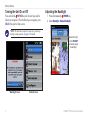
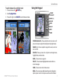
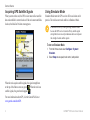
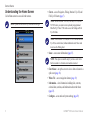
GPSMAP 500 series ® owner’s manual © 2007 Garmin Ltd. or its subsidiaries Garmin International, Inc. 1200 East 151st Street, Olathe, Kansas 66062, USA Tel. (913) 397.8200 or (800) 800.1020 Fax (913) 397.8282 Garmin (Europe) Ltd. Liberty House Hounsdown Business Park, Southampton, Hampshire, SO40 9RB UK Tel.+44 (0) 870.8501241 (outside the UK) 0808 2380000 (within the UK) Fax+44 (0) 870.8501251 Garmin Corporation No. 68, Jangshu 2nd Road, Shijr, Taipei County, Taiwan Tel. 886/2.2642.9199 Fax 886/2.2642.9099 All rights reserved. Except as expressly provided herein, no part of this manual may be reproduced, copied, transmitted, disseminated, downloaded or stored in any storage medium, for any purpose without the express prior written consent of Garmin. Garmin hereby grants permission to download a single copy of this manual onto a hard drive or other electronic storage medium to be viewed and to print one copy of this manual or of any revision hereto, provided that such electronic or printed copy of this manual must contain the complete text of this copyright notice and provided further that any unauthorized commercial distribution of this manual or any revision hereto is strictly prohibited. Information in this document is subject to change without notice. Garmin reserves the right to change or improve its products and to make changes in the content without obligation to notify any person or organization of such changes or improvements. Visit the Garmin Web site (www.garmin.com) for current updates and supplemental information concerning the use and operation of this and other Garmin products. Garmin® is a trademark of Garmin Ltd. or its subsidiaries, registered in the USA and other countries. GPSMAP®, AutoLocate®, BlueChart®, BlueChart® g2 Vision™, TracBack®, BlueChart®, MapSource®, and Ultrascroll™ are trademarks of Garmin Ltd. or its subsidiaries. These trademarks may not be used without the express permission of Garmin. XM WX Weather and XM Radio are trademarks of XM Satellite Radio, Inc. February 2007 Part Number 190-00758-00 Rev. B Printed in Taiwan Introduction Introduction This manual includes information for the following products: GPSMAP® 520/520s GPSMAP® 530/530s GPSMAP® 540/540s GPSMAP® 550/550s GPSMAP® 525/525s GPSMAP® 535/535s GPSMAP® 545/545s GPSMAP® 555/555s Tips and Shortcuts • Press HOME from any screen to return to the Home screen. • Press MENU from any of the main screens to access advanced settings. • Press and release the POWER key to adjust the display settings. Manual Conventions In this manual, when you are instructed to select an item, small arrows (>) appear in the text. They indicate that you should highlight a series of items on the screen using the ROCKER, and press the SELECT key after each item. For example, if you see “select Charts > Navigation Chart,” you should highlight Charts, and press SELECT. Then highlight Navigation Chart, and press SELECT again. Quick Links • • • • • • • • • • • • Turning the Unit On or Off: page 2. Acquiring GPS Satellite Signals page 4. Inserting and Removing SD Cards: page 5. Restoring Factory Settings: page 5. Using the Navigation Chart: page 7. Changing the Chart Settings: page 16. Navigating to a Destination: page 19. Creating a Waypoint: page 21. Configuring System Settings: page 29. Using Sonar: page 35. Installing the Unit: page 39. Alarms and Messages: page 55. GPSMAP® 500 Series Owner’s Manual Introduction Table of Contents Introduction............................................................................i Tips and Shortcuts.................................................................... i Manual Conventions................................................................. i Quick Links................................................................................ i Warnings.................................................................................. iv Important Information............................................................. iv Getting Started......................................................................1 Unit Overview........................................................................... 1 Turning the Unit On or Off....................................................... 2 Adjusting the Backlight........................................................... 2 Using the Keypad..................................................................... 3 Acquiring GPS Satellite Signals............................................. 4 Using Simulator Mode............................................................. 4 Restoring Factory Settings..................................................... 5 Viewing System Information................................................... 5 Inserting and Removing SD Cards......................................... 5 Understanding the Home Screen............................................ 6 ii Using Charts.........................................................................7 Using the Navigation Chart..................................................... 7 Using BlueChart g2 Vision.................................................... 11 Using Mariner’s Eye 3D......................................................... 12 Using Fish Eye 3D.................................................................. 13 Using Fishing Charts............................................................. 13 Enabling High Resolution Satellite Imagery........................ 14 Viewing Aerial Photos............................................................ 15 Viewing Current Station Information.................................... 16 Detailed Road and POI Data.................................................. 16 Using Automatic Guidance.................................................... 16 Changing the Chart Settings................................................. 16 Using the Chart/Sonar Screen.............................................. 18 Where To?...........................................................................19 Navigating to a Destination................................................... 19 Creating and Using Waypoints............................................. 21 Creating and Using Routes................................................... 23 Viewing Information...........................................................25 Viewing Numbers................................................................... 25 Viewing Tide Station Information.......................................... 26 Viewing Current Information................................................. 26 Viewing Celestial Information............................................... 27 Viewing User Data.................................................................. 27 Viewing Other Boats.............................................................. 28 GPSMAP® 500 Series Owner’s Manual Introduction Configuring the Unit...........................................................29 Configuring System Settings................................................ 29 Changing Units of Measure................................................... 29 Configuring Communications Settings................................ 30 Setting Alarms........................................................................ 31 Configuring My Boat.............................................................. 32 Configuring Other Boats....................................................... 34 Configuring XM Audio............................................................ 34 Using Sonar........................................................................35 Understanding the Full Screen............................................. 35 Understanding the Flasher.................................................... 35 Understanding the Split Freq Screen................................... 36 Understanding The Split Zoom Screen................................ 36 Understanding the Temp Log Screen................................... 37 Setting Up Sonar.................................................................... 37 Advanced Sonar Settings...................................................... 38 Appendix.............................................................................53 Specifications......................................................................... 53 Product Registration.............................................................. 54 Caring for the Unit.................................................................. 54 Alarms and Messages............................................................ 55 Weather Data Warranty.......................................................... 59 XM Satellite Radio Service Agreement................................. 60 Software License Agreement................................................ 60 Limited Warranty.................................................................... 61 FCC Compliance..................................................................... 62 Industry Canada Compliance................................................ 62 Optional Accessories............................................................. 62 Index....................................................................................63 Installing The Unit..............................................................39 Step 1: Select a Location....................................................... 39 Step 2: Mount the Unit........................................................... 40 Step 3: Install the Transducer............................................... 42 Step 4: Install the Wiring Harness........................................ 48 Step 5: Test the Installation................................................... 51 GPSMAP® 500 Series Owner’s Manual iii Introduction Warnings Failure to avoid the following potentially hazardous situations could result in an accident or collision resulting in death or serious injury. • When navigating, carefully compare information displayed on the unit to all available navigation sources, including information from visual sightings, and maps. For safety, always resolve any discrepancies or questions before continuing navigation. • • Use the electronic chart in the unit only to facilitate, not to replace, the use of authorized government charts. Official government charts and notices to mariners contain all information needed to navigate safely. Use this unit only as a navigational aid. Do not attempt to use the unit for any purpose requiring precise measurement of direction, distance, location, or topography. WARNING: This product, its packaging, and its components contain chemicals known to the State of California to cause cancer, birth defects, or reproductive harm. This Notice is provided in accordance with California’s Proposition 65. See www.garmin.com/prop65 for more information. Hg - lamps inside this product contain mercury and must be recycled or disposed of according to local, state, or federal laws. For more information go to: www.garmin.com/aboutGarmin/environment/disposal.jsp. Important Information MAP DATA INFORMATION: One of the goals of Garmin is to provide customers with the most complete and accurate cartography that is available to us at a reasonable cost. We use a combination of governmental and private data sources, which we identify in product literature and copyright messages displayed to the consumer. Virtually all data sources contain some inaccurate or incomplete data. In some countries, complete and accurate map information is either not available or is prohibitively expensive. The California Electronic Waste Recycling Act of 2003 requires the recycling of certain electronics. For more information on the applicability to this product, see www.erecycle.org. iv GPSMAP® 500 Series Owner’s Manual Getting Started Getting Started Unit Overview Power/Data GXM 31 antenna External GPS antenna SD card slot GPSMAP 545s shown GPSMAP® 500 Series Owner’s Manual Getting Started Turning the Unit On or Off Press and hold the POWER key until the unit beeps and the Garmin screen appears. When the Warning screen appears, press SELECT to open the Home screen. Note: The first time you power on your unit, you must go through a setup sequence. See page 51 for details. Warning Screen Adjusting the Backlight 1. Press and release the POWER key. 2. Select Backlight > Manual Backlight. Press left or right on the ROCKER to manually adjust the backlight. Home Screen GPSMAP® 500 Series Owner’s Manual Getting Started To switch between Day and Night mode: 1. Press and release the POWER key. 2. Select Day/Night Mode. 3. Press left or right on the ROCKER to switch between modes. Using the Keypad POWER/ BACKLIGHT RANGE (-/+) ROCKER MARK SELECT MENU HOME POWER/BACKLIGHT—Press and hold to turn the unit on or off; press and release to adjust the backlight and day/night modes. RANGE (-/+)—Press to adjust the range of the sonar; zoom in or out on a chart. ROCKER—Press up, down, left, or right to move through menus, highlight fields, and enter data. MARK—Press to mark a waypoint. SELECT—Press to select highlighted items and confirm onscreen messages. HOME—Press to return to the Home screen. MENU—Press to access additional settings and configuration options; press to return to the previous screen when indicated. GPSMAP® 500 Series Owner’s Manual Getting Started Acquiring GPS Satellite Signals When you turn on the unit, the GPS receiver must collect satellite data and establish its current location. If the unit cannot establish a location, the Initialize Position screen appears. Using Simulator Mode Simulator Mode turns the GPS receiver off for use indoors or for practice. The unit does not track satellites in Simulator Mode. Caution: Do not try to navigate using Simulator Mode because the GPS receiver is turned off. Any satellite signal strength bars shown are only simulations and do not represent the strength of actual satellite signals. To turn on Simulator Mode 1. From the Home screen select Configure > System > Simulator. 2. Select Setup to set speed, track control, and position. When the unit acquires satellite signals, the signal strength bars at the top of the Home screen are green . When the unit loses satellite signals, the green bars disappear . For more information about GPS, visit the Garmin Web site at www.garmin.com/aboutGPS. GPSMAP® 500 Series Owner’s Manual Getting Started Restoring Factory Settings You can restore your unit to the original factory settings. Caution: This procedure deletes any information you have entered. To restore factory settings: 1. From the Home screen, select Configure > System > System Information. 2. Select Factory Settings. 3. Select Yes to restore all factory settings. Otherwise, select No to cancel. Inserting and Removing SD Cards Your unit supports Secure Digital (SD) cards. Insert optional BlueChart® g2 Vision™ SD cards to view high-resolution satellite imagery, and aerial reference photos of ports, harbors, marinas and other points of interest. Insert blank SD cards to transfer data such as waypoints, routes, and tracks to another compatible Garmin unit or a PC. The SD card slot is located on the bottom-right corner of the unit. To insert the SD card, press it in until it clicks. Viewing System Information You can view your unit’s software version, basemap version, and unit ID number. You may need this information to update the system software or purchase additional map data information. From the Home screen, select Configure > System > System Information. To remove the SD card, press in on the SD card. The card pops out. GPSMAP® 500 Series Owner’s Manual Getting Started Understanding the Home Screen Use he Home screen to access all other screens. Note: Options on this screen vary based on the unit type. • Charts—access Navigation, Fishing, Mariner’s Eye 3D, and Fish Eye 3D charts (page 7). Note: On the GPSMAP 520/520s, 540/540s, 525/525s, and 545/545s units, you must insert an optional preprogrammed BlueChart® g2 Vision™ SD card to access the Fishing and Fish Eye 3D charts. NOTE: The GPSMAP 530/530s, and 535/535s can use the Fish Eye 3D (on certain lakes) without additional cards. These units do not use the Fishing chart. • Sonar—access sonar information (page 35). Note: This option is available only if you have a unit with a built-in sounder or a Garmin sonar module connected. • Chart/Sonar—set up the screen to view a chart and sonar in a split screen (page 18). • Where To?—access navigation features (page 19). • Information—view information including tides, currents, celestial data, user data, and information about other boats (page 25). • Configure—access unit and system settings (page 29). GPSMAP® 500 Series Owner’s Manual Using Charts Using Charts Your unit has a worldwide imagery map, a built-in detailed map of US inland lakes, or BlueChart g2 cartography for either the US shoreline or a specific country. • Navigation Chart—displays all relevant navigation data available on your preloaded maps, including buoys, lights, cables, depth soundings, marinas, and tide stations in an overhead view. • Mariner’s Eye 3D—a bird’s eye view from above and behind your boat; for a visual navigation aid. Note: If you are using a GPSMAP 520/520s or 525/525s, you must insert an optional BlueChart g2 Vision preprogrammed SD card to view detailed Navigation and Mariner’s Eye 3D charts. Fishing Charts and Fish Eye 3D views are available when using optional Blue Chart® g2 Vision™ preprogrammed SD cards. • Fishing Chart—removes navigational data from the preloaded map, while leaving the bottom contours and depth soundings. (This is not available on the 530/530s and 535/535s - all contour lines and depth soundings appear on the Navigation chart.) • Fish Eye 3D—an underwater view that visually represents the sea floor or lake bottom according to the chart’s information. (This is available for select lakes on 530/530s and 535/535s units without an additional card). GPSMAP® 500 Series Owner’s Manual Using the Navigation Chart Use the navigation chart to plan your course, view map information, and as a navigational aid. Note: For GPSMAP 520/525 units, you must insert an optional BlueChart g2 Vision preprogrammed SD card for your region to view detailed navigation charts. To access a navigation chart, from the Home screen, select Charts > Navigation Chart. Your boat Tide station Exposed wreck Beacon Light Marina services Exposed rock Zoom scale Navigation Chart with g2 Vision Using Charts Navigation Chart Settings To access additional settings or options for the navigation chart, press MENU. Full Screen Map (Show Numbers)—view the navigation or fishing chart in full-screen mode, without numbers. Select Show Numbers to view numbers again. NEXRAD—turn NEXRAD weather data on or off. Note: You must plug the optional GXM 31 antenna into the XM port on the back of the unit and have a subscription to XM Satellite WX Weather to view NEXRAD data. XM is not available on the GPSMAP 520/520s, 525/525s, 550/550s, or 555/555s units. For more information on XM WX Weather, see the GXM 31 Owner’s Manual. Overlay Numbers—show or hide cruising, sailing, navigation, and fishing numbers on the navigation or fishing chart. Chart Setup—customize the navigation chart. See page 16. Chart Notes—access detailed chart information. Full Screen Map Show Numbers GPSMAP® 500 Series Owner’s Manual Using Charts Understanding Chart Data BlueChart g2 Vision and the US inland lake electronic charts use graphic symbols to denote map features. Some common symbols you might see include, but are not limited to, the following*: Dangerous Rock Exposed Rock Beacon Pilot Boarding Area Airport/Seaplane Base Buoy Anchorage Berth Precautionary Area Church Anchoring Prohibited Radio Report Point Exposed Wreck Recommended Anchorage Fishing Harbor Rescue Station Fishing Prohibited Tide Station Information Yacht Harbor Current Station Marine Services *Some symbols might appear differently on your Garmin unit. Other features common to most charts include depth contour lines (with deep water represented in white), intertidal zones, spot soundings (as depicted on the original paper chart), navigational aids and symbols, and obstructions and cable areas. Panning the Navigation Chart Use the map pointer ( ) to pan away from your current location, and scroll to other areas on the navigation chart. As you pan past the edge of the current map display, the screen scrolls forward to provide continuous map coverage. The position icon ( ) stays at your present location. As you move the map pointer, you can view the distance and bearing from your current location, and the map pointer’s location coordinates in the lower-right corner of the map. To pan the map, press up, down, right, or left on the ROCKER. Map pointer Position icon To stop panning, press MENU, and then select Stop Panning. GPSMAP 500 Series Owner’s Manual ® Using Charts Zooming In and Out on the Map The Range (+/-) keys control the zoom level, indicated by the scale at the bottom of the navigation chart ( ). The bar under the number represents that distance on the map. 2. Select the item. If more than one item is in the area, select Review, and then select the item. Accessing Additional Object Information Use the map pointer ( items and waypoints. ) to view information about on-screen map To access additional object information: 1. On the navigation chart, highlight an item with the map pointer, and press SELECT. Selected item 10 GPSMAP® 500 Series Owner’s Manual Using Charts Viewing Tide Station Information Tide station information appears on the chart with a detailed icon showing the relevant tide level. You can view an in-depth graph for a tide station to help predict the tide level at different times or different days. Use the map pointer ( and press SELECT. ) to highlight a tide station icon ( Relevant tide level For more information about tides, see page 26. ), Using BlueChart g2 Vision Optional BlueChart g2 Vision preprogrammed SD cards allow you to get the most out of your unit. In addition to detailed marine charting, BlueChart g2 Vision has the following features: • Mariner’s Eye 3D—a bird’s eye view from above and behind the boat, for a more visual navigation aid. The BlueChart g2 Vision Mariner’s Eye 3D is more detailed than the preloaded data. • Fish Eye 3D—an underwater view that visually represents the sea floor according to the chart’s information. • Fishing Charts—view the chart without navigational data, leaving only the bottom contours and depth soundings. This chart works best for offshore deep-sea fishing. • High Resolution Satellite Imagery—high resolution satellite images are provided for a realistic view of the land and water on the Navigation chart. • Aerial Photos—view marinas and other navigationally significant aerial photos to help you visualize your surroundings. • Detailed Roads and POI data—view roads, restaurants, and other points of interest (POIs) along the shore. • Current Data—view current station information. • Auto Guidance—automatic passage planning software that helps you determine the best course to your destination. GPSMAP® 500 Series Owner’s Manual11 Using Charts Using Mariner’s Eye 3D Mariner’s Eye 3D provides a bird’s eye view from above and behind the boat (according to your course), and provides a visual navigation aid. This view is helpful when navigating tricky shoals, reefs, bridges, or channels, and is beneficial when trying to identify entry and exit routes in unfamiliar harbors or anchorages. Mariner’s Eye 3D Settings To access additional settings or options from the Mariner’s Eye 3D screen, press MENU. Colors—choose between Normal (Default), Water Hazard, and All Hazard. The Normal setting highlights the land as you would see it from the water. The Hazard settings indicates shallow water and land with a color scale. Blue indicates deep water, yellow is shallow water, and red is very shallow. The Water Hazard setting indicates land in green, and the All Hazard setting shows land as dark red. Mariner’s Eye 3D Rings—toggle the range rings on or off. (Water Hazard Colors) Safe Depth—adjust the depth at which red indicates shallow water. Mariner's Eye 3D Navigation Chart The RANGE (+) key moves the view closer to your boat and lower to the water, while the RANGE (-) key moves the view away from the boat. This is indicated by the scale ( ) at the bottom of the screen. 12 Nav Lane Width—adjust the width of the course line drawn when navigating. Numbers—show or hide cruising, navigation, fishing, and sailing numbers. GPSMAP® 500 Series Owner’s Manual Using Charts Using Fish Eye 3D Using Fishing Charts Fish Eye 3D Settings The Fishing chart uses detailed bathymetric data on on a preprogrammed BlueChart g2 Vision SD card, and is best for offshore deep-sea fishing. Using the depth contour lines of the BlueChart g2 Vision cartography, Fish Eye 3D provides an underwater view of the sea floor or lake bottom. The RANGE keys adjust the view in the same way as the Mariner’s Eye 3D. To access additional settings or options for the Fish Eye 3D, screen, press MENU. Sonar Cone—turn a cone on or off that shows the area covered by your transducer. Sonar Data—visually show the sonar readings received by your transducer for the best combination of sonar and mapping. The setting is either on or off. Use the Fishing chart for a detailed, unobstructed view of the bottom contours and depth soundings on the chart. To view the Fishing chart, from the Home screen select Charts > Fishing Chart. Fish Eye 3D Tracks—turn the track log on or off. Note: You need an optional preprogrammed BlueChart g2 Vision SD card for your region to view detailed fishing charts. NOTE: Because the detailed bathymetric information used by the Fishing Chart is recorded specifically for off-shore applications, the Fishing Chart is not available on the GPSMAP 530/530s or 535/535s (inland) units. Numbers—show or hide cruising, navigation, or fishing numbers on the chart. GPSMAP® 500 Series Owner’s Manual13 Using Charts Enabling High Resolution Satellite Imagery You can overlay high-resolution satellite images on the land, sea, or both portions of the Navigation chart when using a preprogrammed BlueChart g2 Vision SD card. NOTE: This feature is preloaded on the GPSMAP 530/530s and 535/535s units. You do not need an additional SD card. To enable satellite imagery: 1. While viewing the Navigation Chart, press MENU. 2. Select Chart Setup > Appearance > Photos. 3. Select one of the following: • Off—standard chart information is shown on the map. • Land Only—standard chart information is shown on water with photos overlaying the land. • On—photos overlay both the water and the land at a specified opacity. The higher you set the percentage, the more the satellite photos will cover both land and water. 14 Photo Overlay Off Land Only Photo Overlay Photo Overlay at 50% Photo Overlay at 100% NOTE: When enabled, the high resolution satellite images are only present at lower zoom levels. If you cannot see the high resolution images in your BlueChart g2 Vision region, either zoom in further using the RANGE (+) key, or set the detail level higher (see page 17). GPSMAP® 500 Series Owner’s Manual Using Charts Viewing Aerial Photos Preprogrammed BlueChart g2 Vision SD cards contain aerial photographs of many landmarks, marinas, and harbors. Use these photos to help orient yourself to your surroundings or to help acquaint yourself with a marina or harbor prior to arrival. To access aerial photos from the navigation chart: ➊ Use the ROCKER to highlight a camera with the pointer. Perspective ➋ Select Aerial Photo. ➌ Select View Fullscreen. Aerial Photo Note: Use the RANGE (+/-) keys to zoom in and out while viewing the aerial photo on the full screen. GPSMAP® 500 Series Owner’s Manual15 Using Charts Viewing Current Station Information If current stations are available in your g2 Vision region, they appear on the navigation chart as a highlighted arrow. This detailed icon shows the current’s speed and direction at a glance. Detailed Road and POI Data Current Station icon Automatic Guidance automatically creates and suggests passage based on available BlueChart g2 Vision chart information. See page 32 for instructions on setting up Automatic Guidance for your boat. The “Where To?” section on page 19 has more information on how to use Automatic Guidance. 16 To change chart settings, from the Home screen, select Charts > Chart Setup. Orientation—change the perspective of the map display: BlueChart g2 Vision contains detailed road and POI data, which includes highly detailed coastal roads and points of interest (POIs) such as restaurants, lodging, local attractions and more. For instructions on searching for and navigating to these POIs, see the “Where To?” section beginning on page 19. Using Automatic Guidance Changing the Chart Settings • North Up—sets the top of the map display to a north heading. • Track Up—sets the map display to the current track heading. • Course Up—sets the map so the direction of navigation is always up and turns the course line vertical on the screen. Heading line Chart border Track GPSMAP® 500 Series Owner’s Manual Using Charts Heading Line—draws an extension from the bow of the boat in the direction of travel. Changing the Chart Appearance • Off—turn off the heading line. • Distance—sets the distance to the end of the heading line. • Time—sets the amount of time until you reach the end of the heading line. Chart Borders—turn on chart borders if you load BlueChart g2 Vision maps and you want to see what areas the maps cover. Detail—adjust the amount of detail shown on the map. Tracks—hide (off) or show (on) tracks on the chart. From the Home screen, select Charts > Chart Setup > Appearance. Press left on the ROCKER to decrease map detail. Press right on the ROCKER to increase map detail. Appearance—customize how items are shown on the map. Photos—set the high resolution satellite images to on, off, or land only. (See page 14 for more information.) Spot Depths—turn on spot soundings and set a dangerous depth. Light Sectors—adjust the drawing of light sectors on the map. Symbols—select the navaid symbol set (NOAA or IALA). Symbol Size—adjust the size of the symbols shown on the map. GPSMAP® 500 Series Owner’s Manual17 Using Charts Using the Chart/Sonar Screen Use the Chart/Sonar screen to view the Navigation Chart, Fishing Chart, Mariner’s Eye 3D, or Fish Eye 3D and sonar at the same time. To access additional settings or options for the chart/sonar screen, press MENU. To view a split chart/sonar screen: 1. From the Home screen, select Chart/Sonar 2. Select the type of chart on the split screen. Navigation chart screen Mariner’s Eye 3D/Sonar Sonar screen Note: The Chart/Sonar screen, like the Sonar screen, is only available when using a sonar capable unit with a transducer attached. Navigation/Sonar Combination 18 GPSMAP® 500 Series Owner’s Manual Where To? Where To? Use the Where To? option on the Home screen to search for, and navigate to, nearby fuel, repairs, marinas, ramps, waypoints, and routes. Note: You have to create waypoints and routes before you can navigate to them. You can navigate to a destination using one of three methods: Go To, Route To, or Guide To. Navigating to a Destination You can search for, and navigate to, nearby destinations including fuel, repairs, marinas, waypoints, and routes. To begin navigating: 1. From the Home screen, select Where To? 2. Select the marine service category to which you want to navigate. The unit shows the list of the 50 nearest locations and the distance to each. • Go To—takes you directly to the destination. • Route To—creates a route from your location to a destination, allowing you to add turns to the route. • Guide To—searches BlueChart g2 Vision chart data to suggest the best path to your destination. Caution: Guide To does not assure obstacle and bottom clearance. For safety, always resolve any discrepancies or questions before continuing navigation. “Where To?” Categories Nearest “Fuel” Search Results GPSMAP® 500 Series Owner’s Manual19 Where To? 3. Select the marine service item to which you want to navigate. A screen containing information about the selected marine service appears. 4. Select Navigate To. 5. Select Go To or Route To. OR Select Guide To when using a preprogrammed BlueChart g2 Vision card to use Auto Guidance. 6. Follow the colored line on the screen to the destination. 20 To stop navigating: Press MENU, and then select Stop Navigating. To search for a destination by name: 1. From the Home screen, select Where To? > Search by Name. 2. Press up or down on the ROCKER to select a number or character; press left or right to move fields. 3. Press SELECT to view the 50 nearest destinations that contain your search criteria. GPSMAP® 500 Series Owner’s Manual Where To? Creating and Using Waypoints You can store up to 1,500 alphanumeric waypoints with a userdefined name, symbol, depth, and water temp for each waypoint. When you create a waypoint, you can designate it as an MOB (Man OverBoard). This marks the point and sets a course back to the marked location. When an MOB is active, an MOB waypoint with an international MOB symbol is created and the unit is on an active navigation to that point. To create a new waypoint: 1. Move the map pointer to the location you want, and press SELECT. 2. Select Create Waypoint. To mark your location: 1. From any screen, press MARK. 2. Select Back to return to the chart, or select MOB to designate the waypoint as an MOB point. Note: Pressing the MARK key only creates a waypoint at your present location. 3. Select one of the following: • Edit Waypoint—customize the waypoint attributes. • Delete—delete the waypoint. • Navigate To—go to the waypoint. • Back—return to the navigation chart. GPSMAP® 500 Series Owner’s Manual21 Where To? To edit a waypoint: 1. Create a new waypoint or select a waypoint on the navigation chart. 2. Select Edit Waypoint. 3. Select the waypoint attribute you want to change (Name, Symbol, Depth, Water Temp, or Position). 22 To move the waypoint on the navigation chart: 1. Select Edit Waypoint > Position > Use Chart. 2. Use the ROCKER to move the waypoint to a different location, and press SELECT. To view a list of all waypoints: From the Home screen, select Information > User Data > Waypoints. GPSMAP® 500 Series Owner’s Manual Where To? Creating and Using Routes You can create and store up to 20 routes, with up to 250 waypoints each. To create a route in another location: 1. From the Home screen, select Information > User Data > Routes > New Route. To create a route from your present location: 1. Move the map pointer to a destination, and press SELECT. 2. Select Navigate To > Route To. Creating a New Route Adding a Turn to a Route 3. Use the ROCKER to add a turn, and press SELECT. Repeat this step to add additional turns. 4. Press MENU to cancel or to begin navigating the route. 2. Use the ROCKER to select the route’s starting point, and press SELECT. 3. Use the ROCKER and SELECT keys to add additional turns. 4. Press MENU to cancel, edit, or navigate the route. GPSMAP® 500 Series Owner’s Manual23 Where To? To edit a route 1. From the Home screen, select Information > User Data > Routes. 2. Select the route to edit. To delete a route: 1. From the Home screen, select Information > User Data > Routes. 2. Select the route to delete, and then select Edit Route. 3. Select Delete. 3. Select Edit Route. You can edit the route name, turns, or delete the route. 24 GPSMAP® 500 Series Owner’s Manual Viewing Information Viewing Information Use the Information screen to access information about user data, tides, currents, celestial data, and other boats. Viewing Numbers To customize the number screen: 1. 2. 3. 4. From the Home screen, select Information > Numbers. Press Menu, and then press SELECT. Select the number of fields to show (3, 4, 5, or 6). Select information to show in each field. You can view and customize numerical data including depth, GPS information, and navigation information. You can customize the number of fields shown and the type of information shown in each field. You can display up to six fields of numerical information. To view the numbers screen, from the Home screen, select Information > Numbers. GPSMAP® 500 Series Owner’s Manual25 Viewing Information Viewing Tide Station Information To view tide information, select Tides from the Information screen, then select a tide station from the list. Tide station Viewing Current Information Use the Current Prediction screen to view information for currents. To view current prediction information, select Currents from the Information screen, then select a Current Station from the list. Local time High tide curve Max. level Current tide height Low tide curve Flood Current (current heading toward shore) Max. level Local time Ebb Current (current heading away from shore) Tide Prediction Chart • To view the Tide Prediction Report, select Show Report. • To return to the Tide Prediction Chart, select Show Tide Chart. Note: You can select both tide and current station information directly from the Navigation chart. See pages 11 and 16 for more information. Tide Prediction Report 26 GPSMAP® 500 Series Owner’s Manual Viewing Information Viewing Celestial Information Use the Celestial screen to view celestial data for sun and moon rise/set, moon phase, and approximate sky view location of the sun and moon. To view celestial information, on the Information screen, select Celestial. To view user data, from the Home screen, select Information > User Data. Waypoints—view a list of all saved waypoints. Routes—view a list of saved routes. Tracks—view a list of saved tracks. Data Transfer—transfer waypoints, routes, and tracks to and from an SD card. Moon position Clear User Data—erase all user waypoints, routes, and tracks. Moon phase Sun position Sky view window Viewing User Data Press left or right on the ROCKER to adjust the time. To transfer data to or from an SD card: 1. Insert an SD card into the SD card slot on the front of the unit. 2. From the Home screen, select Information > User Data > Data Transfer. 3. Complete one of the following: • Select Save To Card to save waypoints, routes, and tracks to the SD card. • Select Merge From Card to transfer data from the SD card to the unit and combine it with existing GPS data. • Select Replace From Card to overwrite items on your unit. GPSMAP® 500 Series Owner’s Manual27 Viewing Information Viewing Other Boats To view information about other boats, from the Home screen, select Information > Other Boats. Note: To view information about other boats, your unit must be connected to an external AIS (Automatic Identification System) or DSC (Digital Selective Calling) device. See page 30 for more information. AIS List—view information about all of the boats your unit is monitoring. The AIS list shows the MMSIs or (if the boat is broadcasting it) names of the AIS boats, and is sorted by range. The boat nearest to your boat appears at the top of the list. DSC Log—view a list of all DSC calls, sorted by most recent, sender, or by type (distress calls or position reports). • View Most Recent—view the seven most recent DSC calls received, sorted and displayed chronologically by time and date. Calls with identical time and date information show the same information in the list. • View By Sender—view an alphanumerical list of senders. • View By Type—view the seven most recent distress calls or position reports, sorted chronologically. DSC Call List—view the 100 most recent calls. The DSC Call List shows the most recent call from a boat. If a second call is received from the same boat, it replaces the first call in the Call List. Directory—view a list of all DSC entries. You can view by name or by MMSI. You can also add an entry. Setup—turn AIS and DSC on or off and set a safe zone for your boat. 28 GPSMAP® 500 Series Owner’s Manual Configuring the Unit Configuring the Unit Use the Configure screen to configure unit settings. Configuring System Settings To change general system settings, from the Home screen, select Configure > System. Simulator—turn Simulator Mode on or off and set Simulator Mode options. (If you set the unit into a Store Demonstration mode during the initial unit setup, this setting will be named Demo.) Language—select the on-screen language. Beeper/Display—select Beeper to set when the unit makes audible sounds. The three settings are Off, Alarms Only (default), and On (keys and alarms). Select Display to switch between Day or Night modes and brighten or darken the backlight. GPS—view GPS satellites, turn WAAS/EGNOS on or off, and initialize the GPS receiver. System Information—view system information and restore factory settings. Event Log—shows a list of system events. Overlay Numbers—set the styles for Wind and Next Turn numbers. Changing Units of Measure To change units of measure, from the Home screen, select Configure > Units. System Units—this is a quick global setting that defines most of the individual units of measure listed below at once. Statute (mh, ft, ºF), Metric (kh, m, ºC), or Nautical (kt, ft, ºF). Depth—individually set the units of measure for depth to Feet (ft), Fathoms (fa), or Meters (m). Temperature—individually set units of measure for temperature to Fahrenheit (ºF) or Celsius (ºC). Note: You must be receiving NMEA Sonar depth data or using a Garmin sounder module to view depth and temperature information. Dist, Spd, Elev—individually set the units of measure for distance, speed, and elevation readings. Heading—set the reference used in calculating heading information. Position—change the coordinate system in which a given location reading appears. The default format is hdddºmm.mmm'. Only change the position format if you are using a map or chart that specifies a different position format. Time—set the time format (12 hour, 24 hour, or UTC time format), time zone, and indicate whether to use daylight saving time. GPSMAP® 500 Series Owner’s Manual29 Configuring the Unit Configuring Communications Settings To change the communications settings, from the Home screen, select Configure > Communications. 2. Select a setting (Sounder, Route, System, or Garmin). 3. Select a NMEA output sentence. Serial Port 1/Serial Port 2—select the input/output format to use when connecting your unit to external NMEA devices, a personal computer, or other Garmin devices. • Garmin Data Transfer—the proprietary format used to upload, download, or exchange data with a computer or another Garmin unit. • Garmin Remote Sonar—allows you to connect a Garmin GSD 21 or GSD 22 serially. • NMEA In/NMEA Out—supports the input or output of standard NMEA 0183 data, DSC, and sonar NMEA input support for the DPT, MTW, and VHW sentences. • NMEA High Speed—supports the input or output of standard 0183 data for most AIS receivers. • None—provides no interfacing capabilities. NMEA Setup—enable or disable NMEA output sentences for sounder, route, system, and Garmin NMEA settings. To enable or disable NMEA output sentences: 1. From the Home screen, select Configure > Communications > NMEA Setup. 30 4. Select Off to disable, or select On to enable the NMEA output sentence. Posn. Precision—adjust the number of digits (Two Digits, Three Digits, or Four Digits) to the right of the decimal point for transmission of NMEA output. Waypoint—select how the unit outputs waypoint identifiers (Names or Numbers). GPSMAP® 500 Series Owner’s Manual