1
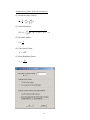
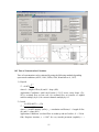
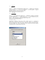
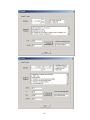
HYDROL-INF Modeling System User’s Manual Version 6.10 Xuefeng Chu, Ph.D. North Dakota State University 06/17/2013 Introduction to HYDROL-INF Version 6.10 A modified Green-Ampt infiltration-runoff model (Chu and Mariño, 2005) is the central part of the Windows-based HYDROL-INF. A new algorithm is proposed for determining the ponding condition, simulating infiltration into a layered soil profile of arbitrary initial water distributions under unsteady rainfall, and partitioning the rainfall input into infiltration and surface runoff. Two distinct periods, pre-ponding and post-ponding, are taken into account. The model tracks the movement of the wetting front along the soil profile, checks the ponding status, and, in particular, handles the shift between ponding and non-ponding conditions. Furthermore, the model has been extended to complex rainfall patterns that include both wet time periods with unsteady rainfall and dry time periods without rainfall. In addition, the SCS-CN model is also included in the Windows system and some useful hydrologic tools have been developed and incorporated in HYDROL-INF. Funded by the National Science Foundation, this new version of HYDROL-INF is developed based on the previous one. Particularly, the modified Green-Ampt model in this new HYDROL-INF accounts for the hydraulic effects of surface ponded water on infiltration and unsaturated flow. Acknowledgements This material is based upon work supported by the National Science Foundation under Grant No. EAR-0907588. The new verion of HYDROL-INF has been incorporated into the P2P Modeling System as a part of the NSF-funded project, titled “CAREER: Microtopography-Controlled Puddle-filling to Puddle-merging (P2P) Overland Flow Mechanism: Discontinuity, Variability, and Hierarchy.” Any opinions, findings, and conclusions or recommendations expressed in this material are those of the authors and do not necessarily reflect the views of the National Science Foundation. It is gratefully acknowledged that permissions to use some published data for estimating model input parameters have been granted by the Food and Agriculture Organization of the United Nations (FAO) and the American Society of Agricultural Engineers (ASAE). Special thanks also to the students in the Watershed Modeling class (CE 476/676) at North Dakota State University and the Hydrology class (NRM 680-A) at Grand Valley State University, for testing the software and providing their feedbacks that have been incorporated in this new version. This software also has been used in the Fluid Mechanics class (CE 309) at North Dakota State University. Notes for Windows Vista and Windows 7 Users The compatibility of HYDROL-INF with the Windows Vista and Windows 7 operating systems has been tested. It works well in both new Windows systems. But, two issues have been noticed: 1. Due to the use of higher security technologies, Windows Vista and Windows 7 do not allow any application programs to copy and write files to the folder: C:\Program 2 Files. Thus, users cannot select any folder within C:\Program Files as their working directory. 2. The Help files in the software require the Windows Help (WinHlp32.exe) program. Starting with the release of Windows Vista and Windows Server 2008, Microsoft has decided to no longer include in WinHlp32.exe as a component of the Windows operating system. For details, please refer to: http://support.microsoft.com/kb/917607 Solution: Users need to download and install WinHlp32.exe. For the Windows Vista operating system, the Windows Help program is available at: http://go.microsoft.com/fwlink/?LinkID=82148. For the Windows 7 operating system, please visit: http://www.microsoft.com/downloads/details.aspx?familyid=258AA5EC-E3D94228-8844-008E02B32A2C&displaylang=en#top Contact Information for limited technical support Dr. Xuefeng Chu Department of Civil Engineering (Dept 2470) North Dakota State University PO Box 6050 Fargo, ND 58108-6050 Tel.: 701-231-9758 Fax: 701-231-6185 E-mail: [email protected] 3 Table of Contents Cover Page -------------------------------------------------------------------------------------------- 1 Introduction to HYDROL-INF Version 6.10 -------------------------------------------------- 2 Table of Contents ------------------------------------------------------------------------------------ 4 List of Tables ----------------------------------------------------------------------------------------- 7 List iof Figures --------------------------------------------------------------------------------------- 8 1. Installation of Hydrol-Inf --------------------------------------------------------------------- 9 2. Instructions for Using Hydrol-Inf ----------------------------------------------------------- 9 3. Overview of the Hydrol-Inf Interface ---------------------------------------------------- 10 3.1 Main Interface ------------------------------------------------------------------------------ 10 3.2 Tool Bar ------------------------------------------------------------------------------------- 11 3.3 File ------------------------------------------------------------------------------------------- 11 3.4 View ----------------------------------------------------------------------------------------- 12 3.5 Data ------------------------------------------------------------------------------------------ 12 3.6 Model ---------------------------------------------------------------------------------------- 14 3.7 Output --------------------------------------------------------------------------------------- 14 3.8 SCS-CN Model ---------------------------------------------------------------------------- 15 3.9 Parameter-Estimation --------------------------------------------------------------------- 17 3.10 Tools --------------------------------------------------------------------------------------- 18 3.11 Window ------------------------------------------------------------------------------------ 19 3.12 Help ---------------------------------------------------------------------------------------- 19 4. File Management ------------------------------------------------------------------------------ 20 4.1 Open an Existing Data File --------------------------------------------------------------- 20 4.2 Save Your Input Data --------------------------------------------------------------------- 20 4.3 Change the Default Directory ------------------------------------------------------------ 20 4.4 Capture a Screen Picture and Copy It to Clipboard ----------------------------------- 20 4.5 Print a Graph ------------------------------------------------------------------------------- 20 4.6 Print a Text File (any input data and output files) ------------------------------------ 20 5. Input Data and Parameter Estimation --------------------------------------------------- 21 5.1 Time Parameters --------------------------------------------------------------------------- 21 5.2 Space Parameters -------------------------------------------------------------------------- 21 4 5.3 Soil Parameters ----------------------------------------------------------------------------- 22 5.3.1 Saturated Hydraulic Conductivity ------------------------------------------------ 22 5.3.2 Effective Hydraulic Conductivity ------------------------------------------------ 23 5.3.3 Capillary Head (Suction) ---------------------------------------------------------- 23 5.3.4 Saturated Water Content ----------------------------------------------------------- 24 5.3.5 Residual Water Content ------------------------------------------------------------ 24 5.3.6 Soil Water Retention Parameter n ------------------------------------------------ 25 5.3.7 Soil Water Retention Parameter α ------------------------------------------------ 26 5.3.8 Field Capacity ----------------------------------------------------------------------- 26 5.3.9 Wilting Point ------------------------------------------------------------------------ 27 5.3.10 Initial Water Content -------------------------------------------------------------- 27 5.4 Meteorologic Data ------------------------------------------------------------------------- 28 5.4.1 Rainfall Intensity -------------------------------------------------------------------- 28 5.4.2 Maximum ET Depth in Soil ------------------------------------------------------- 28 5.4.3 Potential Evapotranspiration ------------------------------------------------------ 29 5.4.4 Crop Coefficient -------------------------------------------------------------------- 29 5.5 Watershed Data ---------------------------------------------------------------------------- 30 6. Data Check and Model Execution --------------------------------------------------------- 32 6.1 Data Check --------------------------------------------------------------------------------- 32 6.2 Model Run ---------------------------------------------------------------------------------- 32 6.3 Check Model Run ------------------------------------------------------------------------- 32 7. Output and Post-Processing ---------------------------------------------------------------- 33 7.1 Water Mass Balance Table and Graph-------------------------------------------------- 33 7.2 Water Table for the Surface Zone ------------------------------------------------------- 35 7.3 Water Table for the Vadose Zone ------------------------------------------------------- 36 7.4 Soil Water Content ------------------------------------------------------------------------ 37 7.5 Soil Water Flow Velocity ---------------------------------------------------------------- 37 7.6 Flow Table for the Watershed Outlet --------------------------------------------------- 38 7.7 Hydrograph at the Watershed Outlet ---------------------------------------------------- 38 7.8 Model Output Information --------------------------------------------------------------- 39 8. SCS-CN Model -------------------------------------------------------------------------------- 40 5 8.1 Theory of the Curve Number Method -------------------------------------------------- 40 8.2 CN Rainfall-Runoff Modeling ----------------------------------------------------------- 41 9. Introduction to the Data Supporting System: Parameter Estimation ------------- 50 10. Hydrologic Tools ------------------------------------------------------------------------------ 51 10.1 Computation of Measured Flow ------------------------------------------------------- 51 10.2 Time of Concentration Calculator ----------------------------------------------------- 55 10.3 24-Hour Rainfall Generator------------------------------------------------------------- 61 11. Help and Documentation -------------------------------------------------------------------- 64 11.1 Help System ------------------------------------------------------------------------------- 64 11.2 Documentation and Support ------------------------------------------------------------ 65 12. References -------------------------------------------------------------------------------------- 67 Appendix 1. Tables -------------------------------------------------------------------------------- 68 Appendix 2. Figures ------------------------------------------------------------------------------- 78 Appendix 3. List of Input Data ----------------------------------------------------------------- 80 6 List of Tables Table 1 Saturated Hydraulic Conductivity KS (cm/hr) --------------------------------------- 68 Table 2 Capillary Head (Suction) HWT (cm) -------------------------------------------------- 68 Table 3 Saturated Water Content WS (cm3/cm3)----------------------------------------------- 68 Table 4 Residual Water Content WR (cm3/cm3) ----------------------------------------------- 69 Table 5 Soil Water Retention Parameter n VN ------------------------------------------------- 69 Table 6 Soil Water Retention Parameter α ALF (1/cm) --------------------------------------- 70 Table 7 Field Capacity FC (cm3/cm3)------------------------------------------------------------ 70 Table 8 Wilting Point WP (cm3/cm3) ------------------------------------------------------------ 70 Table 9 Crop Coefficients and Mean Maximum Plant Heights ------------------------------ 71 7 List of Figures Figure 1 Field Capacity (Carsel et al. 2003) ---------------------------------------------------- 78 Figure 2 Wilting Point (Carsel et al. 2003) ----------------------------------------------------- 79 8 1. Installation of HYDROL-INF Double click the file named “Setup.exe” on the CD drive and then just follow the instructions. After the installation, the HYDROL-INF software can be started from “Start” and “Programs.” One example data file (HYDROL-INF.TXT) is included in the package for testing. If you are using the Windows Vista or Windows 7 operating system, please install the Windows Help program (WinHlp32.exe) (see the Introduction of this document). 2. Instructions for Using HYDROL-INF Use of the interfaced HYDROL-INF is quite simple, which includes three major steps: Step 1: prepare all input data via menu “Data” or import data from an existing data file via menu “File-Open Data” (or button Open Data). Then save the data via menu “Save Data” (or button Save Data) or “Save As”. Step 2: check data and run the model via menus “Model-Check Data” and “ModelRun” (or button Check Data and button Run Model). All time-dependent data, such as rainfall, can be input manually or imported from an existing text or excel file. The data can also be exported to a file. Step 3: Conduct post-processing via menu “Output.” The water mass balance table and graphs of incremental and cumulative rainfall, infiltration, and runoff can be shown via the menu “Water Mass Balance Table” (or button Output Table) and the menu “Rainfall/Infiltration/Runoff Graph” (or button Output Graphs) These outputs can also be exported to Microsoft Excel for further processing (either spreadsheets or graphs) via the menu “Water Mass Balance Excel” (or button Transfer Output to Excel). The graphs can be printed out using menu “File-Print Graph” (or button Print Graph). A graph on the screen can be captured and copied to Clipboard. Additionally, a water table for the surface zone and vadose zone, soil water content, soil water flow velocity, as well as detailed model output information can also be shown via menus. All text-formatted input data and the simulated outputs can be opened and printed via menu “File-Print a Text File.” 9 3. Overview of the HYDROL-INF Interface 3.1. Main Interface The HYDROL-INF menus are organized according to the three fundamental modeling steps: Data, Model, and Output. The SCS-CN model can be accessed via the menu SCS-CN Model. The menu “Parameter-Estimation” is a special component, which serves as a database and helps users to estimate all input data. It provides explanation and estimation methods for all parameters. It also provides a number of links to some existing databases. Additionally, some hydrologic tools/calculators have been incorporated in the modeling system. The help system covers all information related to the three major modeling steps as well as the HYDROL-INF documentation. 10 3.2. Tool Bar The buttons in the tool bar (from left to right) are Open Data, Save Data, Print Graph, Screen Capture, Check Data, Run Model, Output Table, Output Graphs, Transfer Output to Excel, Hydrograph, Computation of Measured Flow, and Time of Concentration Calculator. 3.3. File Open Data (button Open Data): Open an existing data file Save Data (button Save Data): Save the current data Save As: Save the current data to a user-specified data file Default Directory: Specify a working directory. The default directory is “C:\HYDROL-INF\”. Screen Capture (button Screen Capture): Copy a screen image, such as a graph to Clipboard. Print Graph (button Print Graph): Print the current graph. Print a Text File: Open and print a text-formatted input/output file. Exit: Exit the HYDROL-INF. 11 3.4. View Tool Bar: Show/hide the toolbar. Status Bar: Show/hide the status bar. 3.5. Data Time: Time-related parameters. Space: Space-related parameters. Space Parameters Number of Cells in Each Soil Layer Thickness of a Soil Layer Soil: Soil-related parameters. Saturated Hydraulic Conductivity KS Effective Hydraulic Conductivity KE Capillary Head (Suction) HWT Saturated Water Content WS Residual Water Content WR Soil Retention Parameter (n) VN Soil Retention Parameter (α) ALF Field Capacity FC Wilting Point WP Initial Water Content W0 Meteorological Data: 12 Rainfall Intensity (time-dependent data) Maximum ET Depth in Soil Potential ET Rate (time-dependent data) Crop Coefficient (time-dependent data) Watershed Data: 13 3.6. Model Check Data (button Check Data): Check all input data. Run (button Run Model): Execute the model. Check Model Run: Check if the model run is successful. 3.7. Output Water Mass Balance Table (button Output Table) Rainfall/Infiltration/Runoff Graph (button Output Graphs) Water Mass Balance Excel (button Transfer Output to Excel) Water Table for the Surface Zone Water Table for the Vadose Zone Soil Water Content Soil Water Flow Velocity Flow Table for the Watershed Outlet Hydrograph at the Watershed Outlet Model Output Information 14 3.8. SCS-CN Model Theory of the CN Method Equations of the CN Method CN Tables P-Q Curves AMC-I-II-III CN Composite CN with Impervious Area Data Import Data (Open) Working Directory Unit System Selection Time Parameters Watershed Data Rainfall Stream Routing Data Save Data Run CN Model Check Model Run Output Water Summary Table Basin Flow Summary Table Outlet Flow Table Basin Hydrographs Outlet Hydrographs Calibration 15 16 3.9. Parameter-Estimation Time Parameters: Space Parameters: Soil Parameters: Saturated Hydraulic Conductivity Effective Hydraulic Conductivity Capillary Head (Suction) Saturated Water Content Residual Water Content Soil Water Retention Parameter n Soil Water Retention Parameter α Field Capacity Table Figure Wilting Point Table Figure Initial Water Content Soil Websites Meteorologic Parameters: Rainfall Intensity Maximum ET Depth in Soil Potential ET Rate Crop Coefficient Meteorologic Websites Watershed Data: 17 3.10. Tools Computation of Measured Flow (button): Time of Concentration Calculator (button): 24-Hour Rainfall Generator (button): 18 3.11. Window New Window: Cascade: Tile Horizontal: Tile Vertical: Tile Horizontal: Arrange Icons: 3.12. Help Contents: Hydrol-Inf Website: Documentation: About: 19 4. File Management 4.1 Open an Existing Data File If a data file already exists, you can open the file and import all data through menu File-Open Data or button Open Data in the toolbar. When you open an input data file from a directory, that directory will be automatically set as your working directory. 4.2 Save Your Input Data Save your current input data using menu File-Save Data or button Save Data in the toolbar. The default data file name is “HYDROL-INF.TXT” that will be saved in the default directory (C:\HYDROL-INF) unless you specify a different working directory. Whenever you modify the data, you need to save the data before running the model. The current data can also be saved to a user-specified directory and file name by using menu File-Save As. That directory will be set as your working directory. 4.3 Change the Default Directory The default project directory of HYDROL-INF is “C:\HYDROL-INF\”. You can change it and specify your own project directory through menu File-Default Directory. Then your input data and all output files will be stored in that directory. 4.4 Capture a Screen Picture and Copy It to Clipboard You can make a screen capture and copy the graph/text image to clipboard. Then you can paste it to anywhere, such as your Word Document and Powerpoint presentation. 4.5 Print a Graph After creating a graph (e.g., rainfall/infiltration/runoff graph), you can print it through menu File-Print Graph or button Print Graph in the toolbar. You are also able to select your printer, specify its properties, as well as paper size and orientation. Note that this menu works only when a graph window is active. 4.6 Print a Text File (any input data and output files) Using menu File-Print a Text File, you can open and print a text file (any input data and output files). 20 5. Input Data and Parameter Estimation 5.1 Time Parameters Total simulation time steps: NT (In the current program, NTmax=15000) Size of a time step (hr): DT 5.2 Space Parameters Number of soil layers: NL (In the current program, NLmax = 50) Number of cells for each soil layer: NC(I) (In the current program, the maximum number of the total soil cells is set as 1000) Thickness of each soil layer (cm): ZNL(I) Surface storage capacity (cm): SSMAX Based upon soil properties, the entire soil profile is divided into a number of soil layers. Each soil layer further consists of computation cells. 21 5.3 Soil Parameters 5.3.1 Saturated Hydraulic Conductivity Saturated Hydraulic Conductivity (cm/hr): KS Input KS value for each soil layer. KS can be estimated using Table 1. 22 5.3.2 Effective Hydraulic Conductivity Effective Hydraulic Conductivity (cm/hr): KE Input KE value for each soil layer. KE can be estimated from KS using Table 1. 5.3.3 Capillary Head (Suction) Capillary Head (Suction) (cm): HWT Input HWT value for each soil layer. HWT can be estimated using Table 2. 23 5.3.4 Saturated Water Content Saturated Water Content (cm3/cm3): WS Input WS value for each soil layer. WS can be estimated using Table 3. 5.3.5 Residual Water Content Residual Water Content (cm3/cm3): WR Input WR value for each soil layer. WR can be estimated using Table 4. 24 5.3.6 Soil Water Retention Parameter n Soil Water Retention Parameter n: VN “n” is a soil water retention parameter in the van Genuchten model. Input VN values for both surface/root zone and deep vadose zone. VN can be estimated by using Table 5. 25 5.3.7 Soil Water Retention Parameter α Soil Water Retention Parameter α (1/cm): ALF “α” is a soil water retention parameter in the van Genuchten model. Input ALF value for each soil layer. ALF can be estimated using Table 6. 5.3.8 Field Capacity Field Capacity (cm3/cm3): FC Input FC value for each soil layer. FC can be estimated using Table 7. FC can also be estimated by using Figure 1 (Source: Carsel et al. 2003) 26 5.3.9 Wilting Point Wilting Point (cm3/cm3): WP Input WP values for each soil layer. WP can be estimated by using Table 8. WP can also be estimated by using Figure 2 (Source: Carsel et al. 2003). 5.3.10 Initial Water Content Initial Water Content (cm3/cm3): W0 Initial water content represents the average soil moisture condition in each discretized soil cell at the initial simulation time (t = 0). Input W0 values for each soil cell. 27 5.4 Meteorologic Data 5.4.1 Rainfall Intensity Rainfall Intensity (cm/hr): RAINS Rainfall intensity data are needed in the model. The data can be obtained from government agencies’ climate centers, such as NOAA National Climatic Data Center (NCDC) and USDA-NRCS National Water and Climate Center (PRISM). Links to these websites can be found in menu Parameter Estimation. 5.4.2 Maximum ET Depth in Soil Maximum ET Depth in Soil (cm): DMET The maximum ET depth in soil is generally equal to the maximum depth of the crop root zone. The value depends on crop types. 28 5.4.3 Potential Evapotranspiration Rate Potential Evapotranspiration Rate (cm/hr): ET0 Potential evapotranspiration rate data are needed in the model. The data can be obtained from government agencies’ climate centers, such as NOAA National Climatic Data Center (NCDC) and USDA-NRCS National Water and Climate Center (PRISM). Links to these websites can be found in menu Parameter Estimation. 5.4.4. Crop Coefficient Crop Coefficient: KBC Crop coefficient is the ratio of actual crop evapotranspiration ETc to the standard reference crop evapotranspiration (potential evapotranspiration) ET0. KBC = ETc/ET0 The value of KBC can change with crop types and stages of crop growth. The KBC value is small during the initial crop stage, often less than 0.4. The value increases with rapid plant development and reaches a maximum value at the time of maximum or near maximum plant development (it generally ranges from 1.0 to 1.2). As leaves begin to age during the late period, the value begins to decease until it reaches a lower value at the end of the growing period (Allen et al., 1998). The FAO Paper 56 (Allen et al., 1998) provides details on how to determine the crop coefficient. Users can access this reference via the menu Plant Websites. Single (time-averaged) crop 29 coefficients for three typical stages of crop growth (initial, mid, and end) and mean maximum plant heights for non stressed, well-managed crops in subhumid climates (RHmin ≈ 45%, u2 ≈ 2 m/s) can be found from Table 9 (Note: following the original notation, Kc denotes crop coefficient in this table). 5.5 Watersed Data Watershed area (ha): AHA Percentage of directly-connected impervious area (%): IMP Time of concentration (hr): TC Index of the unit hydrograph (1: SCS UH; 2: Clark UH): IUH Basin storage coefficient in the Clark UH (hr): RC Initial baseflow (m3/s): QB0 Baseflow recession constant: RB Baseflow threshold value (ratio to the peak): RTHRE Note that RC is required for the Clark unit hydrograph method only. For watershed modeling, two unit hydrograph techniques (SCS UH and Clark UH) are available for selection. Baseflow is simulated by using the recession method as follows: QB QB 0 rBt where QB0 = initial baseflow; rB = daily recession constant; and t = time (hr). Baseflow is constant (QB0) for rB = 1. Note that the recession constant is dependent on the unit of time (Maidment 1993, page 9.5). A daily recession constant is used in this progam. 30 31 6. Data Check and Model Execution 6.1 Data Check To make sure that all input data and relationship of some interrelated data are in reasonable ranges, the data should be checked by menu Check Data or button Check Data in the toolbar before running the model. Then, a list of warnings and errors will be shown. It is advised that you run the model after eliminating all warnings and errors. 6.2 Model Run Once all data are checked, the model can be executed by clicking Model-Run or button Run Model in the toolbar. 6.3 Check Model Run Check whether or not the model run is successful. 32 7. Output and Post-Processing 7.1 Water Mass Balance Table and Graph Water Mass Balance Table (button Output Table in the toolbar) Rainfall/Infiltration/Runoff Graph (button Output Graphs in the toolbar) Water Mass Balance Excel (button Transfer Output to Excel in the toolbar) A water mass balance table shows incremental and cumulative rainfall (Rain, CRain), infiltration (Infil, C-Infil), runoff (Runf, C-Runf), and evapotranspiration from the surface water storage (ETS, C-ETS), as well as surface storage (SSTG) and the change in surface storage (D-Stg) for each time step. Both incremental and cumulative rainfall and the simulated infiltration and runoff can also be shown in form of graphs. A set of plot parameters will be automatically determined, which include minimum and maximum x values (time), minimum and maximum y values, number of x ticks, number of y ticks, decimal digit of marked x values, decimal digit of marked y values, index of gridlines (0 solid; 1 dash; 2 dot; 3 dash + dot; 4 dash + two dots; and 5 no gridline). The simulated outputs can also be transferred to Microsoft Excel via menu Water Mass Balance Excel or button Transfer Output to Excel in the toolbar. Then these data can be analyzed by using Excel spreadsheet and graphs can also be created within Excel. Note that the data transfer may take a long time for a large data set. Note that the mass balance terms in the aforementioned table and graph (e.g., runoff) are the depths of water over the pervious soil area only. For watershed modeling, total depth of runoff should include the quantities from both pervious area [(1-IMP/100)A] and directly-connected impervious area [IMP/100*A]. 33 34 7.2 Water Table for the Surface Zone Water Table for the Surface Zone A cumulative water mass balance table for the surface zone shows cumulative rainfall (C-Rain), infiltration (C-Infil), runoff (C-Runf), evapotranspiration from the surface water storage (C-ETS), and the surface storage (SSTG) for each time step. Note that the mass balance terms in the table (e.g., runoff) are the depths of water over the pervious soil area only. 35 7.3 Water Table for the Vadose Zone Water Table for the Vadose Zone A cumulative water mass balance table for the vadose zone shows cumulative infiltration (C-Infil), evapotranspiration from the soil profile (C-ET), discharge to the underlying groundwater (C-GW), and changes in the soil water storage (soil water content) (D-WC) for each time step. Note that the mass balance terms in the table are the depths of water over the pervious soil area only. 36 7.4 Soil Water Content Soil Water Content The soil water content table shows both temporal and spatial variations of soil moisture conditions. 7.5 Soil Water Flow Velocity Soil Water Flow Velocity The soil water flow velocity table shows both temporal and spatial variations of soil water flow velocities. 37 7.6 Flow Table for the Watershed Outlet Mass balance table for the entire watershed. Note that the infiltration and runoff from the pervious and directly-connected impervious areas are the depths of water over the entire watershed area. 7.7 Hydrograph at the Watershed Outlet Hydrograph at the outlet 38 7.8 Model Output Information Model Output Information It shows all input data, computation details of the model execution, such as determination of ponding condition. 39 8. SCS-CN Model 8.1 Theory of the Curve Number Method The SCS-CN model is a separate model, in which the SCS-CN method is used to simulate surface runoff. The relevant theoretical information can be accessed via the menu of Theory of the CN Method, including equations, CN tables, P-Q curves, CN values for AMC-I, AMC-II, and AMC-III, and composite curve numbers with impervious areas. Note that the SCS-CN model should be used for event rainfall-runoff modeling only. 40 8.2 CN Rainfall-Runoff Modeling In the CN rainfall-runoff modeling, two different unit systems (SI system and US customary unit system) can be selected. All modeling steps, including data preparation (import data, change working directory, input data, save data), model run and check, and output (view simulation summary tables and hydrographs) can be accessed through the menu SCS-CN Model. The modeling can be conducted for a single watershed or multiple watersheds. Comparison between the simulated and observed hydrographs can also be performed via the menu Calibration. For watershed modeling, either SCS unit hydrograph or Clark unit hydrograph can be selected. Baseflow is simulated by using the recession method (see pages 28-29 for details). Note that the recession constant is dependent on the unit of time (Maidment 1993, page 9.5). A daily recession constant is used in this progam. 41 42 43 44 45 46 47 48 49 9. Introduction to the Data Supporting System: Parameter Estimation To facilitate parameter estimation, a comprehensive data supporting system is developed and incorporated in Hydrol-Inf. All parameters/data used in the model are detailed in the data supporting system. It covers all basic data information, tables, and figures related to soil properties and meteorologic conditions that are included in this document. The data supporting system also includes links to some useful database websites concerning soils and climate. 50 10. Hydrologic Tools 10.1 Computation of Measured Flow Computation of Discharge Generally, both velocity and depth of a stream change significantly over a crosssectional area. The velocity near the water surface is greater than one close to the bottom and the water in the center of the stream flows faster than on the edges. Discharge of a stream through a cross-sectional area A can be expressed as: Q VdA V ( x, y)dxdy A A in which Q = water discharge [L3/T]; V = velocity [L/T]; and A = area [L2]. A number of methods can be used for estimating discharge of a stream. Velocity-area methods are commonly used. Midsection method and mean-section method are two velocity-area methods and the former is generally recommended. As shown in the figure on the following page, the midsection method for calculating water discharge in a stream channel can be written as: L Li 1 L Li Li Li 1 qi Vi Ai Vi i 1 di d i Vi i 1 2 2 2 (i = 2, 3, …, n-1) For the first and last sections, following equations are used for calculating the corresponding discharge (Gupta, 1989): L2 L1 d1 2 in which V1 0.65 V2 q1 V1 Ln Ln 1 dn 2 in which Vn 0.65 Vn1 Hence, the total discharge can be given by: q n Vn n Q qi i 1 in which qi = water discharge of section i [L3/T]; Vi = mean velocity at observation point/vertical i [L/T]; Li = distance from the initial point to observation point/vertical i [L]; and di = depth of water at observation point/vertical i [L]. The number of observation points/verticals or the size of each section depends on the entire width of the stream, variability in the stream depth and velocity, and the degree of precision required (research purposes). Usually, the number of sections/verticals 51 may range from 5 to 20. Some references suggest that 20-30 verticals of equidistant or variable spacings be used to divide a stream width. These spacings also should be arranged so that no section contains more than 10% of the total flow. Computation of Mean Velocity: (1) One-Point Method (0.6D): A velocity is measured at a depth of 0.6D (D is the total depth of water) and it is assumed that this velocity is equal to the mean velocity as shown in the flowing equation. This method is suitable for D 2 ft Vi vi0.6 D (2) Two-Point Method (0.2D & 0.8D): Two velocities are measured at depths of 0.2D and 0.8D. The mean velocity is estimated as follows. This method is suitable for D 2 10 ft Vi 1 0.2 D 1 0.8 D vi vi 2 2 (3) Three-Point Method (0.2D, 0.6D, & 0.8D): Three velocities are measured at depths of 0.2D, 0.6D, and 0.8D. The mean velocity is estimated as follows. This method is suitable for D 10 20 ft Vi 1 0.2 D 1 0.6 D 1 0.8 D vi vi vi 4 2 4 (4) 0.2-Depth Method (0.2D): In this method, it is assumed that the mean velocity equals 0.87 of the velocity measured at a depth of 0.2D. Vi vi0.2 D 0.87vi0.2 D The first two methods are widely used in practice. Ln Li+1 Li Li-1 L2 L1 dn d2 di-1 di 52 di+1 Computation of Other Hydraulic Parameters: (1) Overall Average Velocity: V n Q qi A i 1 n A i 1 i (2) Wetted Perimeter: n WP d1 i 2 d i d i 1 2 Li Li 1 2 (3) Hydraulic Radius: R A WP (4) Conveyance Factor: f K AR 2 3 (5) Slope-Roughness Factor: f sr Q AR 2 3 53 dn 54 10.2 Time of Concentration Calculator Time of concentration can be estimated by using the following methods depending upon actual conditions (ASCE, 1996; USDA, 1986; Wanielista et al., 1997). 1) Kirpich L0.77 Tc 0.0078 0.385 S where L = length of flow (ft) and S = slope (ft/ft) Application Conditions: small rural basins (1.2-112 acres); steep slopes (3%10%); overland flow on bare soil; for overland flow on concrete or asphalt surfaces multiply by 0.4; for concrete channels multiply by 0.2. 2) Izzard 1 41.0250.0007i cr L 3 Tc 1 2 S 3i 3 where i = rainfall intensity (in/hr), cr = retardation coefficient, L = length of flow (ft), and S = slope (ft/ft) Application Conditions: overland flow on roadway and turf surface; iL < 500 in. ft/hr; Requires iteration; cr = 0.007 for very smooth pavement (asphalt); cr = 55 0.0075 for tar and sand pavement; cr = 0.012 for concrete pavement; cr = 0.06 for dense turf. 3) Kerby L0.467n 0.467 Tc 0.8262 S 0.2335 where n = Manning roughness coefficient or retardation coefficient, L = length of flow (ft), and S = mean slope of the basin (ft/ft). Application Conditions: overland flow on small watersheds (<4.047 ha or 10 ac); L< 1000 ft; n = 0.02 for smooth pavement; n = 0.3 for poor grass; n = 0.4 for average grass; n = 0.8 for dense grass. 4) Federal Aviation Agency 0.38841.1 C L0.5 Tc S 0.333 where C = rational runoff coefficient, L = length of overland flow (ft), and S = average overland slope (ft/ft). Application Conditions: overland flow; frequently used for urban basins. 5) Kinematic Wave 0.93L0.6 n 0.6 Tc i 0.4 S 0.3 where n = Manning roughness coefficient for overland flow, L = length of overland flow (ft), i = rainfall intensity (in/hr), and S = average overland slope (ft/ft). Application Conditions: overland flow; L < 300 ft; requires iteration. 6) SCS Lag Equation 0.7 0.8 1000 L 9 CN Tc 0.5 189.62S where L = watershed hydraulic length (ft), CN = runoff curve number, and S = average watershed slope (ft/ft). Application Conditions: agricultural watersheds; small urban basins (< 2000 acres); assuming Tc = 1.67 TL. 7) NRCS TR-55 Sheet flow travel time (min), Tst 0.8 0.42nst Lst Tst 0.5 0.4 P2 S st where nst = Manning’s roughness coefficient for sheet flow, Lst = sheet flow length (ft) (Lst ≤ 300 ft); P2 = 2-year, 24-hour rainfall (in), and Sst = slope of hydraulic grade line (land slope, ft/ft). Shallow concentrated flow travel time (min), Tsc 56 Tsc Lsc 0.5 60 C c S sc where Lsc = shallow concentrated flow length (ft), Cc = channel type coefficient (unpaved channel: Cc = 16.1345; paved channel: Cc = 20.3282), and Ssc = slope of hydraulic grade line (watercourse slope, ft/ft). Open Channel flow travel time (min), Toc 2 Locnoc Pw 3 Toc 2 1 89.4 Ac 3 Soc 2 where Loc = open channel flow length (ft), noc = Manning’s roughness coefficient for open channel flow, Pw = wetted perimeter (ft), Ac = cross sectional area (ft2), and Soc = slope of hydraulic grade line (channel slope, ft/ft). Total time of concentration (min), Tc Tc Tst Tsc Toc Application Conditions: Movement of the surface water in a watershed is characterized by three major types of flow: sheet flow, shallow concentrated flow, and open channel flow; after a maximum of 300 ft, sheet flow becomes shallow concentrated flow; steady uniform sheet flow. 57 58 59 60 10.3 24-Hour Rainfall Generator For a designed rainfall (2-year, 5-year, 10-year, 25-year, 50-year, or 100-year), the USDA-NRCS (SCS) 24-rainfall distributions (USDA, 1986) can be applied to generate the corresponding rainfall time series. In this tool, three parameters need to be specified, which include the number of time points for 24 hours, type of the rainfall distribution (I, II, III, or IA), and the total 24-hour rainfall. The relevant information can be easily accessed via buttons on the interface of the tool. The calculated 24-hour rainfall can also be exported to an EXCEL file. 61 62 63 11. Help and Documentation 11.1 Help System The help system covers all major topics associated with use of the model, input data and parameter estimation, as well as hydrologic tools and documentation. Users can find the answers to most of their questions from the help system. 64 11.2 Documentation and Support This User’s Manual is the primary documentation. To help users understand the underlying theoretical background, relevant papers also are included in this Windows-based model. Additionally, users can visit our Hydrol-Inf website to check any updated information. Limited technical support can be available via e-mail ([email protected]). Any comments and improvement suggestions on HYDROL-INF are greatly appreciated. 65 66 12 References Allen, R.G., L.S. Pereira, D. Raes, and M. Smith. 1998. FAO Irrigation and Drainage Paper No. 56, Crop Evapotranspiration (Guidelines for computing crop water requirements). ASCE. 1996. hydrology Handbook, 2nd Edition. ASCE Manuals and Reports on Engineering Practice No. 28. American Sciety of Civil Engineers. New York. Carsel, R.F., J.C. Imhoff, P.R. Hummel, J.M. Cheplick, and A.S. Donigian, Jr. 2003. PRZM-3, A Model for Predicting Pesticide and Nitrogen Fate in the Crop Root and Unsaturated Soil Zones: Users Manual for Release 3.12. National Exposure Research Laboratory, USEPA. Carsel, R.F. and R.S. Parrish. 1988. Developing joint probability distributions of soil water retention characteristics. Water Resource Research, 24:755-769. Chu, X. and M.A. Mariño. 2005. Determination of ponding condition and infiltration into layered soils under unsteady rainfall. Journal of Hydrology, 313(3-4):195-207. Gupta, R.S. 1989. Hydrology and Hydraulic Systems. Prentice Hall, New Jersey. Maidment, D. R., 1993. Handbook of Hydrology. McGraw-Hill, Inc. New York. Rawls, W.J. and D.L. Brakensiek. 1983. A procedure to predict Green and Ampt infiltration parameters. In: Advances in infiltration: proceedings of the National Conference on Advances in Infiltration, American Society of Agricultural Engineers, pp. 102-112. Rawls, W.J., D.L. Brakensiek, and K.E. Saxton. 1982. Estimation of Soil Water Properties. Transactions of the ASAE, 25(5):1316-1320, 1328. USDA. 1986. Urban Hydrology for Small Watersheds, Technical Release 55 (TR-55). Natural Resources Conservation Services. Wanielista, M., R. Kersten, and R. Eaglin. 1997. Hydrology: Water Quantity and Quality Control, 2nd Edition. John Wiley & Sons, Inc. New York. 67 Appendix 1. Tables Table 1 Saturated Hydraulic Conductivity KS (cm/hr) Soil Texture Class Sand Loamy Sand Sandy Loam Loam Silt Silt Loam Sandy Clay Loam Clay Loam Silty Clay Loam Sandy Clay Silty Clay Clay KS (cm/hr) a 29.7 14.59 4.42 1.04 0.25 0.45 1.31 0.26 0.07 0.12 0.02 0.20 KS (cm/hr) b, c 23.56 5.98 2.18 1.32 0.68 0.30 0.20 0.20 0.12 0.10 0.06 a Carsel and Parrish, 1988. Rawls and Brakensiek, 1983. c Maidment, 1993. b Table 2 Capillary Head HWT (cm) Soil Texture Class Sand Loamy Sand Sandy Loam Loam Silt Loam Sandy Clay Loam Clay Loam Silty Clay Loam Sandy Clay Silty Clay Clay a b HWT (cm) a, b 4.95 (0.97-25.36) 6.13 (1.35-27.94) 11.01 (2.67-45.47) 8.89 (1.33-59.38) 16.68 (2.92-95.39) 21.85 (4.42-108.0) 20.88 (4.79-91.10) 27.30 (5.67-131.50) 23.90 (4.08-140.2) 29.22 (6.13-139.4) 31.63 (6.39-156.5) Rawls and Brakensiek, 1983. Maidment, 1993. Table 3 Saturated Water Content WS (cm3/cm3) Soil Texture Class Sand Loamy Sand Sandy Loam WS (cm3/cm3) a 0.43 0.41 0.41 68 Loam Silt Silt Loam Sandy Clay Loam Clay Loam Silty Clay Loam Sandy Clay Silty Clay Clay a 0.43 0.46 0.45 0.39 0.41 0.43 0.38 0.36 0.38 Carsel and Parrish, 1988. Table 4 Residual Water Content WR (cm3/cm3) Soil Texture Class Sand Loamy Sand Sandy Loam Loam Silt Silt Loam Sandy Clay Loam Clay Loam Silty Clay Loam Sandy Clay Silty Clay Clay a WR (cm3/cm3) a 0.045 0.057 0.065 0.078 0.034 0.067 0.100 0.095 0.089 0.100 0.070 0.068 Carsel and Parrish, 1988. Table 5 Soil Water Retention Parameter n VN a Soil Type Sand Loamy Sand Sandy Loam Loam Silt Silt Loam Sandy Clay Loam Clay Loam Silty Clay Loam Sandy Clay Silty Clay Clay a VN 2.68 2.28 1.89 1.56 1.37 1.41 1.48 1.31 1.23 1.23 1.09 1.09 Carsel and Parrish, 1988. 69 Table 6 Soil Water Retention Parameter α ALF (1/cm) a α (1/cm) a 0.145 0.124 0.075 0.036 0.016 0.020 0.059 0.019 0.010 0.027 0.005 0.008 Soil Type Sand Loamy Sand Sandy Loam Loam Silt Silt Loam Sandy Clay Loam Clay Loam Silty Clay Loam Sandy Clay Silty Clay Clay a Carsel and Parrish, 1988. Table 7 Field Capacity FC (cm3/cm3) a Soil Texture Class Sand Loamy Sand Sandy Loam Loam Silt Loam Sandy Clay Loam Clay Loam Silty Clay Loam Sandy Clay Silty Clay Clay a Sand 85-100 70-90 45-85 25-50 0-50 45-80 20-45 0-20 45-65 0-20 0-45 Textural Properties (%) Silt Clay 0-15 0-10 0-30 0-15 0-50 0-20 28-50 8-28 50-100 8-28 0-28 20-35 15-55 28-50 40-73 28-40 0-20 35-55 40-60 40-60 0-40 40-100 FC (Water Retained at -0.33 Bar Tension) 0.091 (0.018-0.164) 0.125 (0.060-0.190) 0.207 (0.126-0.288) 0.270 (0.195-0.345) 0.330 (0.258-0.402) 0.257 (0.186-0.324) 0.318 (0.250-0.386) 0.366 (0.304-0.428) 0.339 (0.245-0.433) 0.387 (0.332-0.442) 0.396 (0.326-0.466) Rawls et al., 1982. Table 8 Wilting Point WP (cm3/cm3) a Soil Texture Class Sand Loamy Sand Sandy Loam Sand 85-100 70-90 45-85 Textural Properties (%) Silt Clay 0-15 0-10 0-30 0-15 0-50 0-20 70 WP (Water Retained at -15.0 Bar Tension) 0.033 (0.007-0.059) 0.055 (0.019-0.091) 0.095 (0.031-0.159) Loam Silt Loam Sandy Clay Loam Clay Loam Silty Clay Loam Sandy Clay Silty Clay Clay a 25-50 0-50 45-80 20-45 0-20 45-65 0-20 0-45 28-50 50-100 0-28 15-55 40-73 0-20 40-60 0-40 8-28 8-28 20-35 28-50 28-40 35-55 40-60 40-100 0.117 (0.069-0.165) 0.133 (0.078-0.188) 0.148 (0.085-0.211) 0.197 (0.115-0.279) 0.208 (0.138-0.278) 0.239 (0.162-0.316) 0.250 (0.193-0.307) 0.272 (0.208-0.336) Rawls et al., 1982. Table 9 Crop Coefficients and Mean Maximum Plant Heights a Crop Kc ini a. Small Vegetables 0.7 1 Maximum Crop Height h (m) Kc mid Kc end 1.05 0.95 Broccoli 1.05 0.95 0.3 Brussel Sprouts 1.05 0.95 0.4 Cabbage 1.05 0.95 0.4 Carrots 1.05 0.95 0.3 Cauliflower 1.05 0.95 0.4 Celery 1.05 1.00 0.6 Garlic 1.00 0.70 0.3 Lettuce 1.00 0.95 0.3 Onions - dry - green - seed 1.05 1.00 1.05 0.75 1.00 0.80 0.4 0.3 0.5 Spinach 1.00 0.95 0.3 Radish 0.90 0.85 0.3 1.15 0.80 Egg Plant 1.05 0.90 0.8 Sweet Peppers (bell) 1.052 0.90 0.7 b. Vegetables – Solanum Family (Solanaceae) 0.6 2 Tomato 1.15 0.70-0.90 0.6 c. Vegetables – Cucumber Family (Cucurbitaceae) 0.5 1.00 0.80 Cantaloupe 0.5 0.85 0.60 71 0.3 1.002 1.00 0.75 0.90 0.3 0.3 Pumpkin, Winter Squash 1.00 0.80 0.4 Squash, Zucchini 0.95 0.75 0.3 Sweet Melons 1.05 0.75 0.4 0.4 Cucumber - Fresh Market - Machine harvest 0.6 0.5 Watermelon 0.4 1.00 0.75 d. Roots and Tubers 0.5 1.10 0.95 1.05 0.95 0.4 Beets, table 3 Cassava - year 1 - year 2 0.3 0.3 0.80 1.10 0.30 0.50 1.0 1.5 Parsnip 0.5 1.05 0.95 0.4 4 Potato 1.15 0.75 0.6 Sweet Potato 1.15 0.65 0.4 Turnip (and Rutabaga) 1.10 0.95 0.6 0.5 Sugar Beet 0.35 1.20 0.705 e. Legumes (Leguminosae) 0.4 1.15 0.55 Beans, green 0.5 Beans, dry and Pulses 0.4 Chick pea 2 0.90 0.4 1.15 2 0.35 0.4 1.00 0.35 0.4 0.5 0.5 1.05 2 Fababean (broad bean) - Fresh - Dry/Seed 0.5 1.15 1.15 1.10 0.30 Grabanzo 0.4 1.15 0.35 0.8 6 Green Gram and Cowpeas 1.05 0.60-0.35 0.4 Groundnut (Peanut) 1.15 0.60 0.4 Lentil 1.10 0.30 0.5 1.152 1.15 1.10 0.30 0.5 0.5 Soybeans 1.15 0.50 0.5-1.0 f. Perennial Vegetables (with winter 0.5 dormancy and initially bare or mulched soil) 1.00 0.80 Artichokes 0.5 1.00 0.95 0.7 Asparagus 0.5 0.957 0.30 0.2-0.8 Mint 0.6 1.15 1.10 0.6-0.8 Strawberries 0.4 0.85 0.75 0.2 g. Fibre Crops 0.35 Peas - Fresh - Dry/Seed 0.5 72 Cotton 1.15-1.2 0.70-0.50 1.2-1.5 Flax 1.10 0.25 1.2 0.4-0.7 0.4-0.7 1.5 1.15 0.35 Sisal 8 h. Oil Crops 0.35 Castorbean (Ricinus) 1.15 Rapeseed, Canola 0.55 0.3 9 1.00-1.15 0.35 0.6 9 Safflower 1.00-1.15 0.25 0.8 Sesame 1.10 0.25 1.0 Sunflower 1.00-1.159 0.35 2.0 i. Cereals 0.3 1.15 0.4 Barley 1.15 0.25 1 Oats 1.15 0.25 1 Spring Wheat 1.15 0.25-0.410 1 1.15 1.15 0.25-0.410 1 0.25-0.410 Maize, Field (grain) (field corn) 1.20 0.60,0.3511 2 Maize, Sweet (sweet corn) 1.15 1.0512 1.5 Millet 1.00 0.30 1.5 Sorghum - grain - sweet 1.00-1.10 0.55 1.20 1.05 1-2 2-4 Winter Wheat - with frozen soils - with non-frozen soils 0.4 0.7 Rice 1.05 1.20 0.90-0.60 1 Alfalfa Hay - averaged cutting effects - individual cutting periods - for seed 0.40 0.40 0.40 0.95 1.20 0.50 0.90 1.15 0.50 0.7 0.7 0.7 Bermuda hay - averaged cutting effects - Spring crop for seed 0.55 0.35 1.00 0.90 0.85 0.65 0.35 0.40 Clover hay, Berseem - averaged cutting effects - individual cutting periods 0.40 0.4014 0.9013 1.1514 0.85 1.1014 0.6 0.6 Rye Grass hay - averaged cutting effects 0.95 1.05 1.00 0.3 Sudan Grass hay (annual) - averaged cutting effects - individual cutting periods 0.50 0.5014 0.9014 1.1514 0.85 1.1014 1.2 1.2 Grazing Pasture - Rotated Grazing - Extensive Grazing 0.40 0.30 0.85-1.05 0.85 0.75 0.75 j. Forages 73 0.15-0.30 0.10 Turf grass - cool season15 - warm season15 0.90 0.80 0.95 0.85 0.95 0.85 0.10 0.10 k. Sugar Cane 0.40 1.25 0.75 3 Banana - 1st year - 2nd year 0.50 1.00 1.10 1.20 1.00 1.10 3 4 Cacao 1.00 1.05 1.05 3 Coffee - bare ground cover - with weeds 0.90 1.05 0.95 1.10 0.95 1.10 2-3 2-3 Date Palms 0.90 0.95 0.95 8 Palm Trees 0.95 1.00 1.00 8 0.50 0.50 0.30 0.50 0.30 0.50 0.6-1.2 0.6-1.2 Rubber Trees 0.95 1.00 1.00 10 Tea - non-shaded - shaded17 0.95 1.10 1.00 1.15 1.00 1.15 1.5 2 Berries (bushes) 0.30 1.05 0.50 1.5 Grapes - Table or Raisin - Wine 0.30 0.30 0.85 0.70 0.45 0.45 2 1.5-2 Hops 0.3 1.05 0.85 5 0.40 0.90 0.6518 5 Apples, Cherries, Pears -no ground cover, killing frost -no ground cover, no frosts -active ground cover, killing frost -active ground cover, no frosts 0.45 0.60 0.50 0.80 0.95 0.95 1.20 1.20 0.7018 0.7518 0.9518 0.8518 4 4 4 4 Apricots, Peaches, Stone Fruit19, 20 -no ground cover, killing frost -no ground cover, no frosts -active ground cover, killing frost -active ground cover, no frosts 0.45 0.55 0.50 0.80 0.90 0.90 1.15 1.15 0.6518 0.6518 0.9018 0.8518 3 3 3 3 Avocado, no ground cover 0.60 0.85 0.75 3 0.70 0.65 0.50 0.65 0.60 0.45 0.70 0.65 0.55 4 3 2 l. Tropical Fruits and Trees 16 Pineapple - bare soil - with grass cover m. Grapes and Berries n. Fruit Trees Almonds, no ground cover 19 21 Citrus, no ground cover - 70% canopy - 50% canopy - 20% canopy 74 Citrus, with active ground cover or weeds22 - 70% canopy 0.75 - 50% canopy 0.80 - 20% canopy 0.85 0.70 0.80 0.85 0.75 0.80 0.85 4 3 2 Conifer Trees23 1.00 1.00 1.00 10 Kiwi 0.40 1.05 1.05 3 Olives (40 to 60% ground coverage by canopy)24 0.65 0.70 0.70 3-5 Pistachios, no ground cover 0.40 1.10 0.45 3-5 19 Walnut Orchard 18 0.50 1.10 0.65 4-5 Cattails, Bulrushes, killing frost 0.30 1.20 0.30 2 Cattails, Bulrushes, no frost 0.60 1.20 0.60 2 Short Veg., no frost 1.05 1.10 1.10 0.3 Reed Swamp, standing water 1.00 1.20 1.00 1-3 Reed Swamp, moist soil 0.90 1.20 0.70 1-3 1.05 1.05 0.6525 1.2525 o. Wetlands – temperate climate p. Special Open Water, < 2 m depth or in subhumid climates or tropics Open Water, > 5 m depth, clear of turbidity, temperate climate 1. These are general values for Kc ini under typical irrigation management and soil wetting. For frequent wettings such as with high frequency sprinkle irrigation or daily rainfall, these values may increase substantially and may approach 1.0 to 1.2. Kc ini is a function of wetting interval and potential evaporation rate during the initial and development periods and is more accurately estimated using Figures 29 and 30, or Equation 7-3 in Annex 7, or using the dual Kcb ini + Ke. 2. Beans, Peas, Legumes, Tomatoes, Peppers and Cucumbers are sometimes grown on stalks reaching 1.5 to 2 meters in height. In such cases, increased Kc values need to be taken. For green beans, peppers and cucumbers, 1.15 can be taken, and for tomatoes, dry beans and peas, 1.20. Under these conditions h should be increased also. 3. The midseason values for cassava assume non-stressed conditions during or following the rainy season. The Kc end values account for dormancy during the dry season. 4. The Kc end value for potatoes is about 0.40 for long season potatoes with vine kill. 5. This Kc end value is for no irrigation during the last month of the growing season. The Kc end value for sugar beets is higher, up to 1.0, when irrigation or significant rain occurs during the last month. 6. The first Kc end is for harvested fresh. The second value is for harvested dry. 75 7. The Kc for asparagus usually remains at Kc ini during harvest of the spears, due to sparse ground cover. The Kc mid value is for following regrowth of plant vegetation following termination of harvest of spears. 8. Kc for sisal depends on the planting density and water management (e.g., intentional moisture stress). 9. The lower values are for rainfed crops having less dense plant populations. 10. The higher value is for hand-harvested crops. 11. The first Kc end value is for harvest at high grain moisture. The second Kc end value is for harvest after complete field drying of the grain (to about 18% moisture, wet mass basis). 12. If harvested fresh for human consumption. Use Kc end for field maize if the sweet maize is allowed to mature and dry in the field. 13. This Kc mid coefficient for hay crops is an overall average Kc mid coefficient that averages Kc for both before and following cuttings. It is applied to the period following the first development period until the beginning of the last late season period of the growing season. 14. These Kc coefficients for hay crops represent immediately following cutting; at full cover; and immediately before cutting, respectively. The growing season is described as a series of individual cutting periods (Figure 35). 15. Cool season grass varieties include dense stands of bluegrass, ryegrass, and fescue. Warm season varieties include bermuda grass and St. Augustine grass. The 0.95 values for cool season grass represent a 0.06 to 0.08 m mowing height under general turf conditions. Where careful water management is practiced and rapid growth is not required, Kc's for turf can be reduced by 0.10. 16. The pineapple plant has very low transpiration because it closes its stomates during the day and opens them during the night. Therefore, the majority of ETc from pineapple is evaporation from the soil. The Kc mid < Kc ini since Kc mid occurs during full ground cover so that soil evaporation is less. Values given assume that 50% of the ground surface is covered by black plastic mulch and that irrigation is by sprinkler. For drip irrigation beneath the plastic mulch, Kc's given can be reduced by 0.10. 17. Includes the water requirements of the shade trees. 18. These Kc end values represent Kc prior to leaf drop. After leaf drop, Kc end ≈ 0.20 for bare, dry soil or dead ground cover and Kc end ≈ 0.50 to 0.80 for actively growing ground cover (consult Chapter 11). 19. Refer to Eq. 94, 97 or 98 and footnotes 21 and 22 for estimating Kc for immature stands. 20. Stone fruit category applies to peaches, apricots, pears, plums and pecans. 21. These Kc values can be calculated from Eq. 98 for Kc min = 0.15 and Kc full = 0.75, 0.70 and 0.75 for the initial, mid season and end of season periods, and fc eff = fc where fc = fraction of ground covered by tree canopy (e.g., the sun is presumed to be directly overhead). The values listed correspond with those in Doorenbos and Pruitt (1977) and with more recent measurements. The midseason value is lower than initial and ending values due to the effects of stomatal closure during periods of peak ET. For humid and subhumid climates where there is less stomatal control by citrus, 76 22. 23. 24. 25. a values for Kc ini, Kc mid, and Kc end can be increased by 0.1 - 0.2, following Rogers et al. (1983). These Kc values can be calculated as Kc = fc Kc ngc + (1 - fc) Kc cover where Kc ngc is the Kc of citrus with no active ground cover (calculated as in footnote 21), Kc cover is the Kc for the active ground cover (0.95), and fc is defined in footnote 21. The values listed correspond with those in Doorenbos and Pruitt (1977) and with more recent measurements. Alternatively, Kc for citrus with active ground cover can be estimated directly from Eq. 98 by setting Kc min = Kc cover. For humid and subhumid climates where there is less stomatal control by citrus, values for Kc ini, Kc mid, and Kc end can be increased by 0.1 - 0.2, following Rogers et al. (1983). For non-active or only moderately active ground cover (active indicates green and growing ground cover with LAI > about 2 to 3) , Kc should be weighted between Kc for no ground cover and Kc for active ground cover, with the weighting based on the "greenness" and approximate leaf area of the ground cover. Confers exhibit substantial stomatal control due to reduced aerodynamic resistance. The Kc can easily reduce below the values presented, which represent well-watered conditions for large forests. These coefficients represent about 40 to 60% ground cover. Refer to Eq. 98 and footnotes 21 and 22 for estimating Kc for immature stands. In Spain, Pastor and Orgaz (1994) have found the following monthly Kc‘s for olive orchards having 60% ground cover: 0.50, 0.50, 0.65, 0.60, 0.55, 0.50, 0.45, 0.45, 0.55, 0.60, 0.65, 0.50 for months January through December. These coefficients can be invoked by using Kc ini = 0.65, Kc mid = 0.45, and Kc end = 0.65, with stage lengths = 30, 90, 60 and 90 days, respectively for initial, development, midseason and late season periods, and sing Kc during the winter (“off season”) in December to February = 0.50. These Kc's are for deep water in temperate latitudes where large temperature changes in the water body occur during the year, and initial and peak period evaporation is low as radiation energy is absorbed into the deep water body. During fall and winter periods (Kc end), heat is released from the water body that increases the evaporation above that for grass. Therefore, Kc mid corresponds to the period when the water body is gaining thermal energy and Kc end when releasing thermal energy. These Kc's should be used with caution. Allen et al., 1998. 77 Appendix 2. Figures Figure 1 Field Capacity (Rawls and Brakensiek, 1983; Carsel et al., 2003) 78 Figure 2 Wilting Point (Rawls and Brakensiek, 1983; Carsel et al., 2003) 79 Appendix 3. List of Input Data AHA: Watershed area (ha) ALF(I): Soil retention parameter (1/cm) DMET: Maximum ET depth in soil (cm) DT: Size of a time step (hr) FC(I): Field capacity (cm3/cm3) ET0(I): Potential evapotranspiration rate (cm/hr) HWT(I): Capillary head (suction) (cm) IMP: Percentage of directly-connected impervious area (%) IU: Index of the UH method (1: SCS UH; 2: Clark UH) KE(I): Effective hydraulic conductivity (cm/hr) KBC(I): Crop coefficient KS(I): Saturated hydraulic conductivity (cm/hr) NC(I): Number of computation cells for each soil layer NL: Number of soil layers NT: Number of time steps QB0: Initial baseflow (m3/s) RAINS(I): Rainfall intensity (cm/hr) RC: Basin storage coefficient in the Clark UH (hr) RB: Baseflow recession constant RTHRE: Threshold value (ratio to the peak) SSMAX: Surface storage capacity (cm) TC: Time of concentration (hr) VN(I): Soil water retention parameter W0(I): Initial volumetric water content (cm3/cm3) WP(I): Wilting point (cm3/cm3) WR(I): Volumetric residual water content (cm3/cm3) WS(I): Volumetric saturated water content (cm3/cm3) ZNL(I): Thickness of each soil layer (cm) 80