1
13 | GPS Sensor
13.4 Measurement Labels
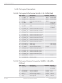
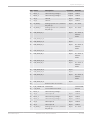
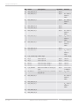
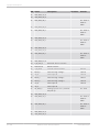
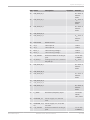
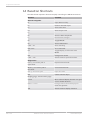
The decoded NMEA messages are copied to these MSI 60 measurement labels.
Measurement label
Function
gps_PDOP
Position Dilution Of Precision
gps_HDOP
Horizontal Dilution Of Precision
gps_VDOP
Vertical Dilution Of Precision
gps_lat
Latitude in NDEG ‐ +/‐[degree][min].
[sec/60]
gps_long
Longitude in NDEG ‐ +/‐[degree][min].
[sec/60]
gps_elv
Antenna altitude above/below mean
sea level (geoid) in meters
gps_speed
Speed over the ground in kilometers/
hour
gps_direction
Track angle in degrees
gps_declination
Magnetic variation degrees (Easterly
var. subtracts from true course)
gps_year
Years since 1900
gps_mon
Months since January ‐ [0,11]
gps_day
Day of the month ‐ [1,31]
gps_hour
Hours since midnight ‐ [0,23]
gps_min
Minutes after the hour ‐ [0,59]
gps_sec
Seconds after the minute ‐ [0,59]
gps_hsec
Hundredth part of second ‐ [0,99]
gps_smask
Mask specifying types of packages from
which data has been obtained
gps_sig
GPS quality indicator (0 = Invalid; 1 =
Fix; 2 = Differential, 3 = Sensitive)
gps_fix
Operating mode, used for navigation (1
= Fix not available; 2 = 2D; 3 = 3D)
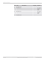
These measurement labels are arrays, where the indexed element points to the
same satellite (E.g. gps_info_satsigstrength[3] tells the receiving signal strength
of satellite 3. Satellite 3 has the SAT‐ID given in gps_info_satid[3]).
104 / 108
Measurement label
Function
gps_info_satid[ ]
Satellite PRN number
gps_info_satinuse[ ]
Used in position fix
gps_info_satelevation[ ]
Elevation in degrees, 90 maximum
gps_info_satazimuth[ ]
Azimuth, degrees from true north, 000
to 359
Modular Sensor Interface MSI 60
Bosch Motorsport