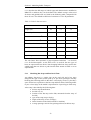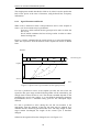
1
DRACULA TRAFFIC MODEL
Version 2.0
User Manual
April 2003
Dr. Ronghui Liu
Institute for Transport Studies
University of Leeds
Leeds LS2 9JT
Tel: +44 (0)113 343 5338
Fax: +44 (0)113 343 5334
E-mail: [email protected]
1
Highlights of DRACULA Version 2.0
This version of documentation describes the 2.0 version of DRACULA as
released in January 2003. It replaces version 1.0 which first released in
October 2000.
There have been many changes both in the way DRACULA models traffic
flow dynamics (see the list below on “Modelling”) and in improving the user
interface (“Technical”). In particular, I would like to mention:
•
•
•
•
•
DRACULA windows front-end (see Section 3.1)
Representation of curved links (Section 8.1.5)
More robust links with SATURN (Sections 4.2, 4.3, 6.2)
New SATURN-style data display program SPATULA (Section 9.2)
Change of file name extensions:
o Rename .PUB files to .BUS to avoid confusion with
Microsoft Publisher files.
o Change text message outputs from files .LPP and .LPS to
.TXP and .TXS respectively to avoid confusion with
SATURN line-printer files.
Modelling
1. Time-dependent demand with fixed assignment modelled as stepfunctions (Section 4.3.1.2).
2. Time-dependent demand with variable assignment from SATURN
multiple-time period modelling (SATTPX/SATSUMA) (Section
4.3.3.3)
3. New junction lane-choice model giving greater opportunity for vehicles
to choose a downstream lane that takes into consideration its next
junction turn - a “looking-ahead” factor. It also considers vehicle types:
slower-moving vehicles made to choose near-side lane and vice versa.
4. Improved overtaking model for long (motorway) links: after overtaking,
vehicles prefer to move back.
5. Modelling yellow-box junctions (Section 6.2.5).
6. Combining rural two-lane overtaking using opposite road space with
ordinary overtaking over multiple lanes in the same direction (Section
8.6).
7. Definition of vehicle-character distributions is extended to include, not
only means and variances, but also upper and lower limits (Section
6.1.3).
8. New DRACULA-style demand input in .TRP files: (a) with a new data
field to represent user class using the route, and (b) time-dependent route
flows to be represented in different .TRP files (Section 4.3.1).
9. Distinction between user class and vehicle type (Section 4.3.1.1).
2
10. New vehicle detector record and new responsive signal control logic.
The detector input includes a new record which specifies the node
number of the junction which is linked to the detection. It is no longer
the downstream node of the link on which the detector is located that is
to be controlled. It is now possible that a detector can be used to control
a junction several links downstream, or a junction not even on any
downstream routes (Section 8.2).
11. New definition of supply and performance measures for network, routes
and links. Outputs in .OUT file (Section 9.1)
12. Link-based (or approach-based) gap acceptance values (Section 6.2.1)
13. Roundabout-specific circulating speed (Section 6.2.3)
14. Simplified coding for two-way bus route and bus route in reverse order
(Section 5.2.1).
Technical
15. Generally, more checks and report on coding errors.
16. New SATURN-style data display program SPATULA which takes
DRACULA simulation outputs (in .SPA file) and produces a .UFD file
which can be loaded to the SATURN program P1X for display (Section
9.2).
17. Representation of curved links, via SATURN-style GIS data input
(Section 8.1).
18. Check for non-connectivity and banned turns in input routes including
bus routes.
19. Automatically convert SATURN bus route information (in card 66666)
into a DRACULA-formatted data file in .BUS (Section 5.2.1).
20. The “name” of a bus route can be alpha-numeric (e.g. a string of
characters and/or numbers) of up to 5 characters (Section 5.2.1).
21. If all or part of a bus route follows a straight line (more or less), it is not
necessary to define every node along the line, only the nodes at the
bends. This applies to the routes that are manually created in a .TRP file.
22. New bus service record in .BUS file: does not require input of
origin/destination zones. This is in recognition the fact that bus services
may not always begin/end in a conventional zone. The old format, where
origin and destination zones for a bus service are coded, can still be used
by setting parameter QOLDBUS=T in .PAR file (Section 5.2.1).
23. A population/vehicle list created by DRACPREP in .VEH file which
contains all vehicles to be simulated and their departure times and
characteristics. This can be used as a fixed population from one
simulation to another (Section 4.3.2).
3
24. Automatically convert SATURN junction-based gap acceptance
parameters (GAP, GAPR, GAPM) to DRACULA-style link-based gap
acceptance values (Section 6.2.1).
25. Read in SATURN files using the DUTCH format.
26. Options in Display menus of DRACULA-MARS Window to change
colour schemes used in simulation, including those to colour a bus lane
and a blocked lane (Section 3.7.2, Appendix B).
27. Check coding on lane usage: whether all lanes been used for turns.
28. All additional network descriptions are to be coded in file .ADD.
Additional coding currently includes: junction-dependent gap acceptance
parameters (Section 6.2.1), roundabout circulating speed (Section 6.2.3),
rural overtaking links (Section 8.6), and ISA speeds (Section 8.4)
29. New SATPIG (with SATURN 10.3) outputs in DRACULA .TRP
format (Section 4.3.3).
30. Definition of input file names via parameters in file .PAR (Sections
2.2.3, 4.2.1 and 4.2.2).
31. Complete parameter lists with cross-reference to the relevant sections in
Manual (Appendix A and B).
32. Displayed clock’s starting time (hour and minute) can be either specified
via parameters (Appendix B) in .PAR file.
33. Setting all link-lengths to that of crow-fly distances between upstream
and downstream nodes, via parameter QCROWFLY in .PAR file
(Section 4.2.2.5).
34. For SATURN-format network coding, various defaults were set in case
of implausible coding. These include setting link-length to the crow-fly
distance and link free-flow speed to 40 km/hr if they were coded as zeros
(Section 4.2.2.5)
35. A windows-based front end DRACWIN from where the DRACULA
programs can be accessed.
4
TABLE OF CONTENTS
1
1.1
1.2
INTRODUCTION................................................................................1
THE DRACULA CONCEPT .................................................................1
OVERVIEW OF DRACULA TRAFFIC SIMULATION MODEL ................2
2
SYSTEM REQUIREMENTS AND ARCHITECTURE...................7
2.1
2.2
COMPUTER SYSTEM REQUIREMENTS .................................................7
MODEL ARCHITECTURE AND DATA REQUIREMENTS .........................7
2.2.1
DRACPREP .............................................................................9
2.2.2
DRACSIM ..............................................................................10
2.2.3
File Names .............................................................................11
3
EXECUTING THE PROGRAMS ....................................................13
3.1
3.2
3.3
3.4
3.5
3.6
3.7
DRACWIN FRONT-END ...................................................................13
RUNNING THE PRE-PROCESSOR ........................................................14
RUNNING THE SIMULATION ..............................................................15
RUNNING THE SPATULA DATA PROCESSING .................................16
ACCESSING THE PROGRAMS FROM SATWIN FRONT-END ...............17
RUNNING THE PROGRAMS IN BATCH MODE ......................................17
THE DRACSIM WINDOW ................................................................18
3.7.1
The Windows..........................................................................18
3.7.2
The Menus..............................................................................19
3.7.2.1
“File” Menu ....................................................................19
3.7.2.2
“Display” Menu..............................................................19
3.7.2.3
“View” Menu..................................................................21
3.7.2.4
“Simulation” Menu.........................................................21
4
BASIC HIGHWAY TRAFFIC NETWORK AND DEMAND.......23
4.1
4.2
CONTROL PARAMETERS FILE (.PAR)................................................23
BASIC HIGHWAY NETWORK .............................................................26
4.2.1
DRACULA Network Coding ..................................................26
4.2.1.1
File Name Specification .................................................27
4.2.1.2
Node and Link Data Formats .........................................28
4.2.1.3
Zone Data Formats .........................................................29
4.2.1.4
Node and Zone Coordinates ...........................................30
4.2.1.5
Turn Priority Marker (TPM) ..........................................31
4.2.1.6
Link Length and Junction Layout ..................................31
4.2.1.7
An example.....................................................................33
4.2.2
SATURN Network Coding .....................................................34
4.2.2.1
Option and parameter specifications ..............................34
4.2.2.2
Simulation Node Data ....................................................36
4.2.2.3
Simulation Link and Turn Data......................................36
4.2.2.4
Simulation Zone Data.....................................................37
4.2.2.5
Node Coordinates and Link Length ...............................37
4.2.2.6
Roundabouts...................................................................37
4.2.3
Signalised Roundabout Model...............................................38
4.2.3.1
Coding instruction ..........................................................39
4.2.3.2
An Example ....................................................................41
4.2.3.3
Lane Choice Modelling at Signalised Roundabouts.......43
4.3 HIGHWAY TRAVEL DEMAND ............................................................44
4.3.1
Average Travel Demand ........................................................44
4.3.1.1
User class vs. vehicle type..............................................45
4.3.1.2
Time-dependent demand with variable route choices ....46
1
Time-dependent demand with fixed route choices.........47
4.3.1.3
4.3.2
Individual Trips .....................................................................48
4.3.3
Route Assignment from SATURN ..........................................49
4.3.3.1
PCU vs. vehicles.............................................................50
4.3.3.2
Multiple user class assignment .......................................51
4.3.3.3
Multiple time period assignment from SATURN ..........51
5
MODELLING PUBLIC TRANSPORT ...........................................52
5.1
THE MODEL ......................................................................................52
5.1.1
Introduction ...........................................................................52
5.1.2
Modelling Public Transport Service......................................52
5.1.3
Modelling Bus Stops and Bus Dwell Time.............................53
5.1.4
Modelling Reserved Lanes.....................................................55
5.2 DATA FILES.......................................................................................56
5.2.1
Bus service data.....................................................................57
5.2.2
Bus stop data .........................................................................59
5.2.3
Reserved bus lane data ..........................................................60
5.3 AN EXAMPLE ....................................................................................61
5.4 GUIDEWAY FOR GUIDED BUSES .......................................................61
6
SIMULATION SETTINGS...............................................................62
6.1
GLOBAL SETTINGS ............................................................................62
6.1.1
Simulation Periods.................................................................62
6.1.2
Vehicle Types .........................................................................64
6.1.3
Vehicle Characteristics..........................................................64
6.1.4
Traffic Composition and Demand Factor..............................65
6.1.5
Car-Following Models...........................................................67
6.1.6
Gap-Acceptance Models ........................................................67
6.1.7
Lane-Changing Models .........................................................69
6.1.8
Reaction to Junction Control.................................................70
6.2 LOCAL SETTINGS ..............................................................................71
6.2.1
Junction- or Link-Specific Gap Acceptance Parameters.......71
6.2.2
Stop-line Location..................................................................72
6.2.3
Roundabout-Specific Circulating Speed................................72
6.2.4
Road Works and Incidents .....................................................73
6.2.5
Yellow Box Junction ..............................................................73
6.2.6
Motorway Merge ...................................................................73
6.2.7
Flared Approaches ................................................................73
7
POLLUTANT EMISSIONS AND FUEL CONSUMPTION .........77
8
ADVANCED SIMULATION OPTIONS .........................................79
8.1
GIS DATA FILE .................................................................................79
8.1.1
Enclosed Polygons.................................................................79
8.1.2
Polylines ................................................................................79
8.1.3
Icons.......................................................................................80
8.1.4
Text ........................................................................................80
8.1.5
Co-ordinates of Curved Links................................................81
8.2 SELECTIVE VEHICLE DETECTORS .....................................................82
8.3 RESPONSIVE SIGNAL CONTROLS ......................................................85
8.3.1
Journey Time Prediction........................................................85
8.3.2
Signal Extension and Recall ..................................................86
8.3.3
Payback .................................................................................87
8.3.4
Cooling-Off Period ................................................................87
8.3.5
Plan-Selection Signal Control ...............................................87
2
8.4
8.5
8.6
8.7
9
SPEED ADVICE AND INTELLIGENT SPEED ADAPTATION ..................88
MODELLING DYNAMIC ROAD PRICING SYSTEMS ............................90
MODELLING OVERTAKING ON TWO-LANE RURAL ROADS ..............91
PEDESTRIAN SIMULATION AND RESPONSIVE SIGNAL CONTROLS ....94
MODEL OUTPUTS AND EVALUATION .....................................95
9.1
9.2
9.3
9.4
9.5
9.6
9.7
9.8
SUMMARY OF OUTPUT FILES .............................................................95
THE SPATULA PROGRAM ...............................................................97
GENERALISED COST .........................................................................98
PERFORMANCE VS SUPPLY MEASURES ............................................99
EXIT MEASURES .............................................................................101
POLLUTION MEASURES...................................................................101
DEFINITION OF QUEUE LENGTH .....................................................102
MULTIPLE SIMULATION RUNS ........................................................102
10
LINKS WITH DRACULA DAY-TO-DAY MODEL ................103
REFERENCES ........................................................................................105
APPENDIX A : CONTROL PARAMETERS FOR DATA PREPROCESSING (DRACPREP)...............................................................107
APPENDIX B: LIST OF THE SIMULATION CONTROL
PARAMETERS (DRACSIM) ................................................................109
APPENDIX C: THE DRACULA-MARS MENUS ..............................113
3
Section 1: Introduction
1
1.1
INTRODUCTION
The DRACULA Concept
The dynamic network microsimulation framework DRACULA (Dynamic
Route Assignment Combining User Learning and microsimulation) has been
developed at the University of Leeds since 1993 (Liu et al 1995). It adapted a
new approach to modelling road traffic networks whereby the emphasis is on
the “microsimulation” of individual trip makers’ choices and individual
vehicles’ movements. The model attempts to represent directly the behaviour
of individual drivers and vehicles in real-time as these evolve from day to
day. This is coupled with a detailed within-day traffic simulation model of the
second-by-second movements of individual vehicles according to carfollowing, lane-changing rules and traffic controls. In combination they model
the evolution of the traffic system over a representative number of days so
that both within-day and between-day variabilities are included and
interaction between the demand and supply modelled.
The full DRACULA framework combines a number of sub-models. The
demand model represents the day-to-day variability in total demand within a
fixed departure time period. It simulates for each potential traveller - based on
individual drivers’ knowledge of the network, their past experience and
perceived network condition of the day - whether to travel, if so, the route to be
taken, and the preferred departure time. This information is then passed to the
traffic simulation model which represents the within-day variability of
network conditions and simulates individual vehicles movements through the
network following the routes chosen and records their travel performance. At
the end of the day (the study period), a learning model updates the experiences
of each individual and stores the information in their travel history files which,
to a greater or lesser extent, influence their next day’s choices.
The current release version, code named DRACULA-MARS (Microscopic
Analysis of Road Systems), includes only the traffic simulation model and a
simplified departure-time choice model of DRACULA. This version is
designed primarily for existing SATURN users who can combine the
SATURN route assignment with DRACULA traffic micro-simulation for
detailed network design and/or short-term forecasting. Hence route assignment
is an input exogenous to the model.
Within MARS, however, there are functions for choice of departure-time to be
modelled (see Section 4.3), and a wide range of network variability and traffic
dynamics. These include modelling of:
(a) variability in network demand (such as daily fluctuation in demand
and temporal distribution of demand) and supply conditions (such as
those due to weather and incidents);
(b) many dynamic phenomena, such as congestion build-up, blocking
back, gap-acceptance and merging, more realistically;
(c) complex traffic controls such as flared approaches, shared lanes and
dynamic responsive traffic signal controls;
(d) public transport operation and bus priority measures;
(e) dynamic traffic demand management measures (such as congestion
pricing).
Through its animation, MARS gives a graphical representation of the network
performance.
1
Network
Representation
Section 1: Introduction
1.2
Overview of DRACULA Traffic Simulation Model
The traffic model in DRACULA is a micro-simulation of the movement of
(pre-specified) vehicles through the network. Drivers follow their predetermined routes and en-route they encounter signals, queues and interact
with other vehicles on the road. A large number of such microscopic vehicle
models have been developed in the past at varying levels of complexity and
network size (e.g. in some the network is effectively a single intersection).
An essential property of all such models is that the vehicles move in realtime and their space-time trajectories are determined by, e.g., car following
and lane-changing models and network controls such as signals.
The simulation is based on fixed time increments; the speeds and positions of
individual vehicles are updated at an increment of one second. Spatially, the
simulation is continuous in that a vehicle can be positioned at any point
along a link. The model includes an animated graphical display of vehicle
movements in the network.
The simulation starts by loading the simulation parameters, network data
including global and local variations and trip information (demand and
routes determined by the demand model). It then runs through an iterative
procedure at the pre-defined time increments, within which the following
tasks are performed:
a. [Initialisation] Set within-day simulation clock t=0.
b. [Vehicle Generation] Generate new entry vehicles at their preferred
departure-time and place them on their entrance links.
c. [Vehicle Movement] Loop through all vehicles in the network, and for
each of them:
i. check if the vehicle wants to change lane, if so whether the gaps are
acceptable;
ii. update the vehicle’s speed and acceleration and advance it to its
new position. At the end of the link, either remove the vehicle from
the network (if it arrives at its destination) or pass it to its next link
en-route.
iii. Calculate vehicle emissions and fuel consumption, and record
traffic performance measures;
d. [Animation Update] Update the graphical display if required.
e. [Traffic Control Update] For each signalised junction, update the stage
change-over clock according to desired signal plans (fixed plans or
responsive). Check if the any incident is to start or to finish.
f.
[Time Update] If all drivers have finished their journey, terminate the
day; otherwise increment the simulation clock and return to step b.
The network is represented by zones, nodes, links and lanes. A zone is the
source or sink of traffic where they enter or leave the network. A node is
either external connecting to a zone or an intersection connecting to other
2
Simulation
Loop
Section 1: Introduction
nodes inside the network. In DRACULA, there is no restriction on the
number of roads connecting an intersection.
A link is a directional roadway between two nodes and consists of one or
more lanes. A link is specified by its upstream and downstream nodes,
cruise speed, number of lanes, turns permitted to other outbound links from
the downstream node, and restricted access (such as reserved lanes). For
each permitted turn, the lane(s) in the link that can use this turn are specified
and a marker describing its priority over opposing flows is given.
In the model traffic moves in lanes. A lane can be reserved for a particular
type(s) of vehicles only (for example a reserved bus lane). The reservation is
specified by its start and end position on the lane and, optionally, by a start
and end time of its operation. See Section 4.2.
Vehicle
Characteristics
Vehicles are individually represented; each has a set of individual
characteristics including vehicle type (car, bus, guided-bus, taxi, heavy goods
vehicle); vehicle length; desired minimum distance headway; normal and
maximum acceleration; normal and maximum deceleration; desired speed
(relative to the mean speed on any individual link) and a gap-acceptance
parameter. These characteristics are randomly sampled from normal
distributions representative of that type of vehicle. See Section 6.1.3.
Public transport vehicles are represented with additional information such as
service number, service frequency, bus stops and average passenger flows at
each bus stop, etc. See Section 5.
Vehicle
Simulation
Vehicle movements in a network are determined by its desired movement
(such as desired speed, lane choice), response to traffic regulations and
interactions with neighboring vehicles. The simulation maintains a linked
list of vehicles in each lane and moves individual vehicles according to a carfollowing model and a lane-changing model, and their response to traffic
controls at intersections.
The car-following model calculates a vehicle’s acceleration in response to its
desired speed and the relative speed and distance of the preceding vehicle.
Depending on the magnitude of the relative distance, a vehicle is classified
into one of three regimes: free-moving, following or close-following.
The lane-changing model contains three steps: (1) obtain the lane-changing
desires and define the type of changing, (2) select the target lane, and (3)
change lane if all gaps are acceptable.
The model divides drivers’ lane-changing desires into one of six types when
drivers have to or want to change lane in order to:
(a) reach a bus stop on the link;
(b) avoid a restricted-use lane or incident;
(c) make their turn from the next junction;
(d) move into a lane reserved for their type;
(e) gain speed by overtaking a slower moving vehicle by changing to a
lane in the same direction; or
(f) overtake a slower moving vehicle by changing to a lane in the
opposite direction of traffic.
3
Section 1: Introduction
As a measure of network performance, the simulation outputs (by default)
network-, link- and route-specific measures such as total vehicle-hour, total
vehicle-km, average travel time, speed, queue length, fuel consumption and
pollutant emission over regular time periods. The length of the report time
period can be defined by the user. At the user’s request, the program may
also output individual vehicles’ second-by-second locations and speeds to
provide space-time trajectories of the vehicles. A graphical animation of the
vehicles’ movements can also be shown in parallel with the simulation,
giving the user a direct view of the traffic conditions on the network. See
Section 9.
A new program, called SPATULA (Section 9.2), has been written to convert
the link-based simulation results into a SATURN-style data file which can
then be input to a SATURN program P1X for display and for comparison
with SATURN simulated results.
4
Simulation
Outputs
Section 2: System Requirement and Model Architecture
2
2.1
SYSTEM REQUIREMENTS AND ARCHITECTURE
Computer System Requirements
DRACULA is written in C/C++ and compiled with Salford C/C++ and
Salford/ClearWin+ for running on PCs under 32-bit Windows systems
(Windows XP, 2000, NT, and earlier Windows systems). A typical
specification for a system to run DRACULA would include:
Table 2.1 System requirements
Hardware
Software library
Screen setting
2.2
Requirements
64MB RAM, 0.5GB hard disk,
Windows XP or earlier systems
Salflibc.dll
True colour (32 bit)
Model Architecture and Data Requirements
There are two main programs in DRACULA-MARS:
(1)
a pre-processor called DRACPREP which processes the input data
and creates the required environment for the microsimulation; and
(2)
a traffic microsimulation program called DRACSIM.
The data required for DRACULA-MARS includes: the travel demand data
(in terms of routes used, flow on each route, and, optionally, drivers’
preferred departure times), the network topology, traffic controls and
simulation control parameters. Figure 2.1 shows the architecture of
DRACULA-MARS and depicts the relationship between the two programs
with the input data required and the output data files produced. Details of the
input and output files are explained in Sections 2.2.1 and 2.2.2. Section 2.2.3
explains file name conventions.
7
Section 2: System Requirement and Model Architecture
Basic Input Data:
Network (*.net)
Demand (*.trp) (*.lpg)
Selective Input Data:
Public Transport (*.pub)
Detector (*.det)
Additional Network (*.add)
Pedestrian Network (*.wkw)
GIS Feature (*.gis)
Selective Input Data:
Simulation Parameter (*.par)
DRACPREP
Status Report
(*.txp)
Supply Data (*.sup)
Demand Data (*.dem) (*.veh)
DRACSIM
Status Report
(*.txs)
Network Performance
(*.out) (*.reb) (*.spa)
Pollution
(*.pol)
Individual Vehicle’s
Travel Performance
(*.ltt) (*.trj)
Fig. 2.1 DRACULA-MARS architecture.
8
Bus Performance
Passenger Delay
(*.psn) (*.ptt)
Detector
Report
(*.txd)
Section 2: System Requirement and Model Architecture
2.2.1
DRACPREP
Function:
DRACPREP creates the database, including the network
topology, traffic regulation and traffic demand, which is to
be used by DRACSIM. Tables 2.2 and 2.3 list the input and
output data files for DRACPREP.
Table 2.2 Input data files for DRACPREP.
Data Type
Details of Input Data
Basic inputs
Network description. See Section 4.2
.NET
Travel demand in terms of routes and route
flows (Section 4.3)
.TRP
Control parameters (Section 4.1).
.PAR
Public transport services (Section 5.2)
.BUS
Selective vehicle detector information
(Section 8.2).
.DET
Additional network data inputs
(Section 6.2).
.ADD
Pedestrian network and flows
(Section 8.7).
.WKW
Selective Inputs
File
Extension
Table 2.3 Outputs from DRACPREP.
Data Type
Details of Output Files
Default
Text reports of the status of the process
.TXP
Network supply description.
.SUP
List of route and route flows.
.DEM
List of individual trip departure-time, route
and vehicle characteristics. See 4.3.2.
.VEH
Optional
File
extension
The text messages in file .TXP contain useful information on the status of
the DRACPREP process. If DRACPREP fails to complete successfully,
you will be prompted with a screen message asking you to check in the file
for error messages. The file also contains warning messages; one particular
warning is about the inconsistency between coded link length and crow-fly
distance between node coordinates (Section 4.2.2.2). It is advisable to check
9
Section 2: System Requirement and Model Architecture
the file for any warning and error messages before proceeding on to
DRACSIM.
The data in .SUP and .DEM are information on the network description and
aggregated demand re-formatted for DRACSIM. They are not meant for
users to look at, nor to change. The outputs in .VEH list individual trip’s
departure-time, identification of the route it is to take, and characteristics of
the vehicle. A detailed description of its format is given in Section 4.3.2.
2.2.2
DRACSIM
Function:
DRACSIM performs the actual simulation of individual
vehicles’ movement in the network following fixed routes.
Tables 2.4 and 2.5 list the input and output data files for
DRACSIM.
Table 2.4 Input data files for DRACSIM.
Data Type
Details of Input Data
File name and
extension
Basic inputs
Network supply description
.SUP
List of routes and aggregated route .DEM
flows
Selective inputs
Simulation control parameters
.PAR
Individual trip departure-time, route .VEH
and vehicle characteristics.
GIS features. See Section 8.1
Global input
.GIS
GIS
background
map
(under .BMP
development)
Specification of vehicle characteristics VEH.TAB
(Section 6.1.3).
Emission and fuel consumption factors POL.TBA
(Section 7).
The “basic” and “selective” inputs are network dependent, whilst the “global
inputs” are not.
Depending on the choices provided by the user in the parameter control file,
different levels of details are output ranging from the most detailed secondby-second vehicle trajectories, to aggregated link, route and network
measures. Format of the output files are described in Section 9.
10
Section 2: System Requirement and Model Architecture
Table 2.5 Outputs from DRACSIM.
Data type
Details of Output Files
Default
Text message reporting the status of .TXS
simulation
Summary
statistics
performance measures
File extension
on
travel .OUT
Summary statistics on exit measures
.REB
Network and link performance .SPA
measures for use with SPATULA
Summary
measures
Optional
statistics
on
pollution .POL
Individual vehicles’ link travel time
.LTT
Individual buses link travel time
.PTT
Summary of passenger delays and bus .PSN
dwell times
Detector records of passing vehicle’ .TXD
speed and type
Trajectories for selected vehicles
2.2.3
.TRJ
File Names
Unless specified otherwise via the method described below, all input data
files for each network should be stored in the same directory. The outputs
files from DRACPREP and DRACSIM will be in the same directory. Both
the file name and the directory name should be a string of alpha-numeric
characters without a white space in between. For example, a name should not
be named as OTLEY BASE, nor should it be stored in directory
c:\Program Files\.
The extensions of all the input and output files used in DRACULA (As
listed in Tables 2.3-2.5) are fixed. For example, a file used to specify an
input network description has to have an extension of .NET, and the output
pollution measures can only be found in a file with extension .POL.
By default, all the input data files for the same network should have the same
name and it is the name of the .NET file. For example, a network called
OTLEY will have its parameter control file named OTLEY.PAR, trip file
OTLEY.TRP, etc.
However, different names can be used for different input files for the same
network. This can be done via parameters in the .PAR file (see Section 4.1
11
Section 2: System Requirement and Model Architecture
for the format of .PAR file). Table 2.6 lists the parameters used
(“PARAMETER”) and the extension of their corresponding files
(“EXTENSION”). Only the names of the files need to be entered;
DRACPREP and DRACSIM will automatically pick up the relevant
extensions. For example, for specify otley.BUS, set BUSFIL=otley.
This facility is useful to allow the same input file be used in a number of
different scenario testing. For example, the same demanded trips
OTLEY.TRP can be used as basis for two different network descriptions
OTLEY1.NET and OTLEY2.NET.
Table 2.6 Parameters used to specify the file names.
PARAMETER
FILTRP
FLTRP(t)
EXTENSION
.TRP
.TRP
FILBUS
FILDET
FILADD
FILWKW
FILGIS
FILSUP
FILDEM
FILVEH
FILTXP
FILLTT
FILOUT
FILPOL
FILREB
FILSPA
FILTXS
FILPTT
FILPSN
FILTXD
FILTRJ
FILPIG
.BUS
.DET
.ADD
.WKW
.GIS
.SUP
.DEM
.VEH
.TXP
.LTT
.OUT
.POL
.REB
.SPA
.TXS
.PTT
.PSN
.TXD
.TRJ
.LPG
N.B.
(i)
(ii)
NOTE
* Input data, or
* Input trip data for time
period t. Section 4.3.1.2
* Input data
* Input data
* Input data
* Input data
* Input data
* Transient data
* Transient data
* Input/output data
Output data
Output data
Output data
Output data
Output data
Output data
Output data
Output data
Output data
Output data
Output data
Input data. Section 4.3.3
Before DRACPREP can load in the correct network-coding
format (see the two different ways of coding networks in Sections
4.2.1 and 4.2.2), the relevant parameter needs to be specified in
.PAR file. Hence, the .PAR file has to bear the same name as that
of the .NET file.
As an experiment, those filenames with * marked in the “NOTE”
section can also be specified in the network description file .NET.
See Sections 4.2.1 and 4.2.2. for coding details. Please let
Ronghui Liu know which options you prefer.
12
Section 3: Executing the Programs
3
EXECUTING THE PROGRAMS
Programs within the DRACULA suite can be accessed using either the
DRACWIN (Section 3.1) or the SATWIN (Section 3.5) windows-based front
ends, or via batch mode commands under Command Prompt (Section 3.6).
3.1
DRACWIN front-end
The DRACPREP and DRACSIM can be accessed via a Windows front-end
for DRACULA from a program called DRACWIN.EXE
Double click the icon ‘DRACWIN’ on the desktop or DRACWIN.EXE, the
interface ‘DRACULA CONTROL’ pops up to load the front-end.
There are six menus on the top main menus:
Programs Folder
-
to change the path of executive files (i.e.
DRACSIM.exe,
DRACPREP.exe,
and
SATURN batch file SPATULA.BAT)
Module Run
to execute the programs: DRACPREP,
DRACSIM, SPATULA
Command Line Run to run the executive programs with DOS
Command
Demos
to display DRACULA simulation runs on
demonstration networks
Tools/Command Prompt- to provide the user familiar with DOS
command to use DOS/Prompt
Help
Version Information
13
Section 3: Executing the Programs
3.2
Running the Pre-Processor
Start DRACPREP from main menu ‘Module Run’-‘DRACPREP’.
The dialogue ‘DRACULA DATA PRE-PROCESSOR’ then pops up.
14
Section 3: Executing the Programs
Click ‘Load Network’ button to load network, or, type the network full path
name (e.g. d:\Dracula\net1.net ) into the text box.
Finally, start the pre-process by clicking ‘Run’ button.
3.3
Running the Simulation
Load the program from main menu ‘Module Run’-‘DRACSIM’. The
dialogue ‘DRACULA MICRO-SIMULATION’ pops up.
15
Section 3: Executing the Programs
Click ‘Load Network’ button to load network, or input the network full path
name (e.g. C:\Dracula\ net1.sup ) into the text box. To start the simulation,
click the ‘Run’ button.
3.4
Running the SPATULA Data Processing
SATURN users also benefit from a new program SPATULA which converts
DRACSIM time-dependent link performance measures to SATURN format.
See Section 9.2 for details on how to load SPATULA outputs into
SATURN/P1X for data analysis.
Step 1. Run SATURN on the network to produce .UFS file
Step 2. Choose program folder for $SPATULA.EXE.
Step 3. Load the program from main menu ‘Module Run’-‘SPATULA’.
Step 4. Click ‘Load Network’ button to load network.
or,
input the network full path name (e.g. C:\Dracula\net1.spa) into the
text box, similar to 4.2 step 4.
Step 5. Start the process by clicking ‘Run’ button.
16
Section 3: Executing the Programs
3.5
Accessing the Programs from SATWIN front-end
SATURN users can access the DRACULA programs from within the
SATURN Launch Pad, SATWIN. Select menu:
SATWIN/Module Run/DRACULA/DRACPREP
SATWIN/Module Run/DRACULA/DRACSIM
SATWIN/Module Run/DRACULA/SPATULA
enter the names of the network data (with extension .NET) to DRACPREP,
the pre-processed supply data file (extension .SUP) to DRACSIM, and the
simulation output file (.SPA) to SPATULA respectively.
3.6
Running the programs in batch mode
Alternatively, the programs can be run with two commands from the main
menu “Command Line Run” Prompt or DOS/Prompt as:
DRACPREP netname
DRACSIM netname
SPATULA netname
17
Section 3: Executing the Programs
3.7
3.7.1
The DRACSIM Window
The Windows
Upon starting the simulation, you will get a main (parent) window with a
title bar across the top, reading “DRACULA – MARS (#.#)”, where (#.#)
gives the version number of the software.
Inside this main DRACULA screen are three child windows: “Animation”,
“Text report” and “Simulation Speed”. At the start of a simulation, the
animation window lies on top of the text window. By clicking anywhere on
any of the other two windows, you can bring it to the front. The child
windows are restricted within the parent window.
On top of the parent window are four menu bars which provide user
interfaces to the simulation program. The details of the menu options are
described in 3.7.2.
The animation window displays the simulated network. To get a closer view
of any part of the network, use the left-hand button on the mouse to select
the area of interest, then click on menu option View/Box to zoom in.
The text window is used to display information about the simulated network
and messages regarding the simulation process at the end of the simulation.
At the start of the simulation, the screen is blank.
The simulation speed window allows users to control the simulation speed,
normally turning the simulation slower so to be able to see the vehicle
movements more clearly. The window also displays the number of vehicles
in process and the number of vehicles from the demand period to be
18
Section 3: Executing the Programs
processed. The simulation ends when all vehicles from the demand period
have completed their journey.
3.7.2
The Menus
3.7.2.1
“File” Menu
Open network Screens
-
3.7.2.2
enable the user to load the network to be simulated
enable the user to choose two colour settings: 256
colours or 16/32 bits
“Display” Menu
Network Info and Demand Info - Related information given in the Text
Report Window (as shown below)
Node Number and Bus-stop Number -Show the nodes numbers and busstop numbers on the respective locations on the
network
GIS Data
- toggle between display or not the network GIS
information in the simulated area, e.g. curved links,
building
Background map
- under development
Colour settings
- A window will pop up which allows changes to the
default colour settings for the animation.
19
Section 3: Executing the Programs
Click on the colour to change and enter the corresponding integer number as
defined in Table 3.1.
Table 3.1 Colour coding
Code
0
1
2
3
4
5
6
7
8
9
10
11
12
13
14
15
Colour
BLACK
BLUE
GREEN
CYAN
RED
MAGENTA
BROWN
GREY
DARKGREY
LIGHTBLUE
LIGHTGREEN
LIGHTCYAN
LIGHTRED
LIGHTMAGENTA
YELLOW
WHITE
20
Section 3: Executing the Programs
3.7.2.3
“View” Menu
Full Network
enables the whole simulated network to be displayed
in the animation window.
Box enable the user to get a closer view of any part of the network. Use the
left-hand button on the mouse to select the area of interest,
then click on menu option Box to zoom in.
Other options (e.g. left, right, up) also enable the user to move to any
interested parts of the simulated network.
3.7.2.4
“Simulation” Menu
Display vehicle by
provides options to display the colour of
vehicles by type, junction turning, route or randomly.
Animation by
options to display the animation by
individual vehicles, or aggregated link delay.
21
Section 3: Executing the Programs
22
Section 4: Basic Highway Traffic Network and Demand
4
BASIC HIGHWAY TRAFFIC NETWORK AND DEMAND
The input data required to run DRACULA-MARS are divided into
fundamental data and advanced data. The former is essential to run the
model, while the advanced data allows optional model features to be
activated. This section provides an introductory discussion on the structure
and the fundamental input data files that are used to build a basic highway
traffic network model.
Most of the data are input via text files which can be created or edited with a
text editor (e.g. EDIT, BRIEF, WORDPAD or NOTEPAD). It is advisable
not to use any word-processor for the editing. SATURN users can use
P1X/PMAKE for network editing.
4.1
Control parameters file (.PAR)
The control parameters define the options for input data, output data and traffic
simulation. They are stored in an ASCII text file with the same name as that of
the network description and extension .PAR. All parameters have default
values; so if a parameter is not specified, its default value is used. If only the
default values are used for this run, the file does not need to be created - hence
it being one of the selective inputs (see Section 2.2).
The parameter should contain at least a beginning and an end identifier:
PARAMETERS and END. Any parameter to be specified must always be set
between the two identifiers. Any text or space outside identifiers
PARAMETERS and END is ignored by the program, and so can be used to
insert comments.
Unlike SATURN where several parameters and their values can be entered
on the same line, in DRACULA, each parameter and its value must be
entered on a separate line. There can be comments on the same line as the
parameters, but they must be (a) entered after the parameter definition and
(b) separated from the parameter definition by at least one space. Parameter
names are case insensitive – any lower case characters are translated into
upper case.
The parameter values can be logical (T or F stands for TRUE or FALSE
respectively), integer or real parameters. In the case of a real parameter
value, the number can be input as either real value or integer numbers.
Some of the parameters are used in the pre-processing stage, others are
relevant to the simulation. The list of user-definable parameters is long,
many of the variables and their use are complicated. The full list of the
parameters used in DRACPREP and DRACSIM are given in Appendix A
and B respectively, with pointers to appropriate sections given. A subset of
parameters, given in Tables 4.1 and 4.2 for DRACPREP and DRACSIM
respectively, is suggested as reasonable starting points where explicit choices
need to be made.
23
Section 4: Basic Highway Traffic Network and Demand
Table 4.1 Parameters defining the options of basic input data to
DRACPREP
Parameter
NSEED
Defaults
Definition
800
Random number seed. An integer number
(preferably of three or more digits) to trigger a
pseudo random number generator. Used both in
DRACPREP and DRACSIM.
QSATNET
T
T if to take SATURN-format simulation
network; F to use the free-format network
coding as described in Section 4.2.2.
QSATPIG
F
F if to take routes and route flows from input file
.TRP of format defined in Section 4.3.1;
Else if T, take them from .LPG files (4.3.3)
QBUS
F
T if to load bus service, bus stops and bus lanes
from .BUS file (Section 5.2.1)
LEFTDR
T
F if driving on the right (e.g. European driving)
XYUNIT
1.0
Factor converting one unit of node/zone
coordinates to metres. Default: 1coordinate unit
=1metre. If XYUNIT=10, then 1 unit of
coordinate=10m. Same as used in SATURN, so
can also be specified in the network description
file .NET (Section 4.2.1)
GONZO
1.0
Demand factor: number of vehicles (of all types)
are factored by GONZO.
VCPCU
1.0
Per car unit used to convert flow given in pcu or
pcu/hr to number of vehicles or vehicles/hr.
Default: 1 pcu = 1 vehicle of type CAR. See
Sections 4.3.3.1.
CIRC_SPEED
27
Roundabout circulating speed (km/hr). See
Section 4.2.2.3
CIRC_RADIUS
4
Minimum radius of roundabout central island
(metres). See Section 4.2.2.3.
QRBLANE
T
If T the number of lanes on a roundabout is
limited to at least equal to the maximum lanes
on entry arms. F if the circulating lanes are
determined from SATURN roundabout capacity.
See Section 4.2.2.3.
NSTEP
1
Number of time periods. See Section 4.3.1
NMUC
1
Number of user classes. See Section 4.3.2
24
Section 4: Basic Highway Traffic Network and Demand
Table 4.2 Parameters defining the basic options for DRACSIM
Parameter
Defaults
Definition
NSEED
800
Random number seed
TMAIN
60
Simulation time period (minutes). Over-written
by LTP in SATURN network coding (Section
4.2.2.1)
TWARM
10
Warm-up period (minutes)
TCOOL
10
Cooling-off period (minutes)
TOUTPUT
10
Frequency of output statistics (minutes)
PPM
1.0
Pence per minute, used for
generalised costs. See Section 9.3
PPK
0.0
Pence per km. Section 9.3
calculating
An example of a .PAR file is shown below.
PARAMETERS
CIRC_SPEED=20
QSATNET=T
NMUC=3
MUC(1)=1
MUC(2)=8
MUC(3)=16
END
Note that the parameters file needs to be created only when some changes to
the default values are expected. For example, using the above file, the round
about circulating speed would be reduced to 20 km/hr from the default 27
km/hr (see Section 6.2.3). The network is coded in SATURN format (Section
4.2.2). There are three user classes in the traffic flow; they are of vehicle
types CAR, TAXI and LGV (see Section 6.1.2 for definitions of vehicle
type).
25
Section 4: Basic Highway Traffic Network and Demand
4.2
Basic Highway Network
The network data is stored in file .NET.
A DRACULA network is represented by zones, nodes, links and lanes.
Zones are an abstract concept representing the sources or sinks of traffic
where they enter or leave the network. They could be used to represent a
housing estate, a car park, or simple connections with traffic from outside the
network.
A node is either external connecting to a zone or an internal intersection
connecting to other nodes. There is no restriction on the number of roads
connected to an intersection.
A link is a directional roadway between two nodes and consists of one or
more lanes. A link is specified by its upstream and downstream nodes, cruise
speed, number of lanes, and turns permitted to other outbound links from the
downstream node. For each permitted turn, the lane(s) in the link that can
use this turn are specified and a marker describing its priority over opposing
flows is given. A lane can be reserved for a particular type(s) of vehicles
only (for example a reserved bus lane). This section defines coding of a
basic highway network which has no reserved lanes; the latter is described in
Section 5.4.
Zones and nodes are named with a number. There should be a unique
number for each zone and a unique number for each node. The numbers do
not need to be sequential. In addition nodes and zones may have the same
numbers. DRACULA network coding adopted a convention used in
SATURN to distinguish a zone number from a node number by including the
character “C” with the zone numbers.
A .NET file may use one of two different coding conventions: (a) that used
by SATURN networks (Section 4.2.2) and (2) a DRACULA-specific set of
records (4.2.1). Note that the SATURN-formatted files contain a lot of data
that is not required by DRACULA and equally do not contain all the
information which DRACULA may make use of. Nevertheless they offer a
convenient starting point for users with existing SATURN networks.
4.2.1
DRACULA Network Coding
To describe a basic highway network, there are five sections of records;
records 1 and 5 are discretionary whilst records 2-4 are mandatory. Each
section is preceded by a line containing a string beginning with character
“&” and followed by a section name, and terminated by a line containing a
single record 99999. The five sections are:
1.
Section 1
– File name description. Preceded by “&FNAME”.
2.
Section 2 – Node and link description. Preceded by “&LINKS”.
Within this Section, there are three types of records:
26
Section 4: Basic Highway Traffic Network and Demand
1)
Record type 1 – Node description (mandatory). One
record for each node.
2)
Record type 2 – Link description (mandatory). One
record for each link in strict clockwise1 order but
starting with any arbitrary link.
3)
Record type 3 – Traffic signal stage description. Only
required for traffic signalised nodes. One record per
stage is input.
3.
Section 3 – Description of zones. Preceded by “&ZONES”.
One record per zone.
4.
Section 4 – Node/zone coordinates. Preceded by “&COORD”.
One record per zone/node coordinates.
5.
Section 5 – Partially signalised roundabout. Preceded by
“&SRBS”. See Section 4.2.3 for details.
Coding instructions and a worked example for a basic network are given in
the following sub-sections. The “NAME” provides an convenient shorthand
for data fields for later discussion, while “DATA” column records the
number of fields for the record.
Data fields are free-format; there is no column restriction. The only
requirements are: (a) different field being separated by a space unless
specified otherwise, and (b) each record type being entered on a separate line
with a line-break immediately following the last data entry of the record.
There should be no white space(s) at the end of a record.
4.2.1.1
File Name Specification
File names in this section must be preceded by a single line containing the
string “&FNAME” and terminated by a single line containing “99999”. The
names should be entered one per line. The following files can be specified
this way are listed in Table 2.6, marked with an *.
An example of filename specification is shown below:
&FNAME
FILTRP=ottrip1
FILBUS=otbus
99999
1
Counter-clockwise under drive on the right
27
Section 4: Basic Highway Traffic Network and Demand
4.2.1.2
Node and Link Data Formats
Data in this section must be preceded by a single line containing the string
“&LINKS” and terminated by a single line containing “99999”.
For internal nodes, all three record types of Section 2 data are required to
give a complete description of the nodes, its links, and signal timings (for
traffic signal control intersection). For external nodes, only those starred (*)
variable “NAME”s of record types 1) and 2) need to be included.
DATA NAME
DESCRIPTION
***********RECORD TYPE 1 – NODE DATA ***************
1
2
3
NODE*
NIN*
JTYPE*
4
QYELL
5
NSTAGE
or
HICD
6
7
or
ZERO
OFFSET
or
NRBL
or
ZERO
LCY
or
CSPEED
8
or
ZERO
GAP
or
BLANK
Node number
Number of arms at the node
Node type:
0 for external nodes
1 for priority junctions
2 for roundabouts with or without U-turn
3 for traffic signals
4 for a dummy node
(5 not in use currently)
6 for a new roundabout model, see 4.2.3.
a character “y” or “Y” entered immediately after
JTYPE – no space in between JTYPE and QYELL
to indicate the junction is in yellow-box control. See
6.2.4.
Number of stages – traffic signals only (JTYPE=3)
or
half inscribe circular diameter (metres) –
roundabouts only (JTYPE=2 or 6), see 4.2.3
or
0 for other junction type
Relative offset – traffic signals only
or
Number of roundabout lanes – roundabouts only
or
0 for other junction type
Cycle time for this node (seconds), for traffic
signals
or
Roundabout circulating speed (kph), see 4.2.3 and
6.2.2.
or
0 for other junction type
Junction-specific gap-acceptance value (seconds).
See 6.2.1.
or
left blank if not to specify
******** RECORD TYPE 2 – LINK DATA ********
28
Section 4: Basic Highway Traffic Network and Demand
One record for each of the NIN links:
1
2
ANODE*
LANES *
Node at the upstream end of the link
Number of entry lanes for this link
0 if the link is one-way from ‘NODE’ to ‘ANODE’
3
SPEED *
Link free-flow speed (kph)
4
IDIST*
Distance (meters) measured from the centre of
‘NODE’ to the centre of ‘ANODE’. See 4.2.2.
Data for the first turn from this link, clockwise from left for left-hand driving
and anti-clockwise from right for right-hand driving condition:
5
LANE1
First lane used by this turn (counted from the
nearside/kerbside, kerbside lane=1)
0 if the turn is banned.
6
TPM
Turn priority marker for this turn. This is to be
entered immediately following LANE1 – there
should be no space between LANE1 and TPM. See
4.2.1.4.
7
LANE2
Last lane used by this turn. 0 if the turn is banned.
Data for the second turn from this link:
…. Same entries as for the first turn
Data for the last turn from this link. The maximum number of turns (being
possible or banned) equals to the number of arms to the junction.
…. Same entries as for the first turn
******** RECORD TYPE 3 – SIGNAL DATA ********
One record for each of the NSTAGE stages:
1
2
3
4
5
6
STAGL
Duration of stage (seconds)
INTG
Duration of following inter-green (seconds)
GNA(1)
The entry-node for the first turn
GNC(1)
The exit-node for the first turn
GNA(2)
The entry-node for the second turn
GNC(2)
The exit-node for the second turn
etc etc… with all permitted turns coded on the same line
NOTES:
(i)
If any exit-node GNC() above is zero it is assumed that ALL
turning movements from that entry-node GNA() (except of course
any prohibited movements indicated by zero turning lanes LANE1
and LANE2) are allowed.
(ii)
All movements permitted in one stage need to be coded on the
same line.
4.2.1.3
Zone Data Formats
29
Section 4: Basic Highway Traffic Network and Demand
Data in this section must be preceded by a single line containing string
“&ZONES” and terminated by a single line containing “99999”.
DATA NAME
DESCRIPTION
1
2
3
Zone number
Upstream node of the link connecting the zone
Downstream node of the link connecting the zone
ZONE
NODEA
NODEB
N.B. Strictly speaking, node NODEA should be of type “external” where
traffic enters to and leaves from the network. In SATURN-formatted
networks (Section 4.2.2), it is possible that a zone is connected to an internal
node. In that case, DRACULA treats the node as though it is “external” such
that no traffic control applies to traffic entering/leaving the network at that
node.
4.2.1.4
Node and Zone Coordinates
Data in this section must be preceded by a single line containing string
“&COORDS” and terminated by a single line containing “99999”.
DATA NAME
DESCRIPTION
1
NODEN
2
3
XCORD
YCORD
Node or zone number, a character C in front of a
number denotes a zone. See note (i)
Its X co-ordinate; see note (ii)
Its Y co-ordinate
NOTES:
(i)
All nodes and zones should be given co-ordinates. An error is
registered if co-ordinates are not given for any node or zone and
DRACPREP will terminate un-successfully.
(ii)
In principle, the units used for XCORD and YCORD are
arbitrary. They are converted to real “size” in meters by
parameter XYUNIT specified in parameter file .PAR (Table
4.1). However, it is strongly recommended that co-ordinates are
defined in metres and that XYUNIT is set to 1.0.
(iii)
Nodes or zones within this section which have not already
appeared in the Node or Link records are ignored by the
program.
30
Section 4: Basic Highway Traffic Network and Demand
4.2.1.5
Turn Priority Marker (TPM)
(N.B. for right-hand drive read left for right in this note and vice-versa.)
The markers describe which traffic flows oppose a turning movement. The
naming of TPM follows that of SATURN. However, there are more TPM
modelled by SATURN than those currently represented in DRACULA. The
ones modelled in DRACULA are:
G
- Used at a priority junction to indicate the turn which must give way
(from a minor road). As defined in SATURN, “a G priority marker
indicates either a ‘give-way’ or a ‘sharing’ movements whereby a
turn marked G gives way to all “major” turning movements (i.e.
those without any priority marker or an X) but ‘shares’ with other
give-way movements” (van Vliet & Hall, 2002).
X
-
M -
F
for opposed right turn which must cross a major flow from the
opposite direction. This could be a major flow turning right at a
priority junction or at a signalised junction.
A turn merges with another turning movement will have equal
priority. Hence whichever vehicle arrives at the junction first
would have priority to go first. This marker could be applied to
both priority and signalised junctions.
- for a permanent filter at traffic signals which has 100% green all the
time.
BLANK – no opposing flow.
4.2.1.6
Link Length and Junction Layout
The coded link-length is defined in both DRACULA and SATURN as the
distance between the centre of the upstream junction and the centre of the
downstream junction, along the path of the road. The path may be a straight
line between the upstream and downstream nodes, or it could be curved
making the length of the path longer than crow-fly distance between the
upstream and downstream nodes.
However, unlike SATURN which doe not model the physical size of a
junction (except for Node Graphics display). DRACULA explicitly models
the physical layout of intersections and estimates the size of an intersection
from the number of lanes of the links and a fixed lane-width therefore the
“effective” or “inter stop line” length of a link in DRACULA is the linklength taking away the distance between the centre of the upstream junction
to the entry of the link and the distance between the centre of the
downstream junction to the stopline of the link.
It can happen that a negative length is calculated in the above method. This
could be due to an un-realistically short link-length coded in SATURN
which was used to connect two very close intersections, or due to an
incorrect interpretation of junction size (see Section 4.2.2.3). When a
31
Section 4: Basic Highway Traffic Network and Demand
negative link-length is detected, a warning message is given in the preprocessing report file .TXP. If a negative link-length is not corrected, the
simulation will still run with vehicles “jumping” over the link without
stopping. However, it is advisable to check the report file for any such
warnings.
In many networks (particularly SATURN-based), XYUNIT is left to its
default value, 1.0, even though the node co-ordinates input are not in metres.
This does not affect the SATURN results as it only uses the link-length as
defined in node/link records. However, DRACULA simulates individual
vehicles’ second-by-second movements over the length of the link, and then
projects the movements onto the physical length of the link in animation. It,
therefore, requires the perfect matching of the physical length of a link with
the link-length as interpreted from the data coded in the simulation node/link
records. Try to make a link’s crow-fly distance (if it is on a straight-line) or
its physical length (if on a curved road) match with the link length. Check
file .TXP for those grossly incomparable.
Experience shows that the true value of XYUNIT in SATURN networks is
often 10 (i.e. co-ordinates are defined to the nearest 10 metres).
If one wants to use crow-fly distance as the link-length, set the following
parameter in .PAR file:
QCROWFLY=T
In addition, DRACPREP sets various defaults in case of implausible coding.
These include setting the link length to the crow-fly distance if it was coded
as zero or left blank. Similarly, a 40 km/hr speed is assigned as link free-flow
speed should it was coded as zero of blank.
32
Section 4: Basic Highway Traffic Network and Demand
4.2.1.7
An example
An example coding is given below to describe the network shown in Fig. 4.1
with four external nodes, two intersections – one signalised (node 2) and the
other priority control (node 3). Traffic from link 6-3 gives way to traffic on
link 2-3. The route flow for this example is given in Section 4.3.1.
1
2
3
4
2
1
5
3
6
4
stages
37
3
17
3 (sec)
Fig. 4.1 An example network. Numbers in rectangles display the node
numbers, while those in triangles are the zone numbers. Junction number 2
is signalised; a stage diagram with permitted turning movements and stage
length is shown.
NETWORK:
&LINKS
1
dtest.net
1
2
0
2
3
1
3
5
3
3
2
6
4
3
5
6
99999
&ZONES
99999
&COORD
99999
37
17
1
2
3
4
1
2
3
4
5
6
C1
C2
C3
C4
4
1
1
1
1
4
5
6
0
3
1
1
1
1
1
1
2
3
2
60 0
30.0 200
0
30.0 200
3
1 0
3
5 0
0
0
0
0
1
1
0
0
0
0
1
1
0
30.0
200
1
1
0
30.0
200
0
0
1G
30.0
200
0
0
2
3
2
2
-300
0
-100
0
100
0
300
0
-100 -200
100 -200
-500
0
500
0
-150
-250
150 -250
33
1
Section 4: Basic Highway Traffic Network and Demand
4.2.2
SATURN Network Coding
SATURN simulation networks can be used as the base for a DRACULA
highway network. To start with an existing SATURN network data file,
rename the SATURN network data file .DAT to .NET.
DRACULA uses the simulation network of SATURN only. See Chapter 6 of
the SATURN Manual for network coding, in particular coding for simulation
network (record 11111) and node coordinates (55555). If there are buffer
links in the network, you need first to convert them into simulation links within
SATURN.
[Hint: use SATURN P1X/Network editor]
Not all sections/records of a SATURN network data file are used in
DRACULA. The ones adopted by DRACULA are:
1
2
3
4
5
6
–
–
–
–
–
–
OPTION SPECIFICATION RECORD
PARAMETER SPECIFICATION RECORD
SIMULATION NODES AND LINKS (RECORD 1)
SIMULATION ZONES (RECORD 2)
NODE AND/OR ZONE COORDINATES (RECORD 5)
FIXED (BUS) ROUTES (RECORD 6)
Most of the SATURN records on simulation nodes, links, zones (including
buffer zones) are used straight-forwardly by DRACULA in a similar way as
they are used in SATURN. For a detailed description of SATURN network
coding, readers are referred to Chapter 5 and 6 of the SATURN Manual (van
Vliet & Hall, 2002).
Within the sections of data adopted, the SATURN variables used and their
interpretation into DRACULA model variables are given in the following
sub-sections, except for the bus routes (data record 5 above) which is
described in Section 5. Particular attention is given to the adaptation and
interpretation of data records which are different from their SATURN use
and/or are not used by DRACULA.
DRACULA does not accept SATURN sub-files using the “&INCLUDE”
facility. Users will have to embed the data into the main .NET file.
4.2.2.1
Option and parameter specifications
SATURN parameter specification records set user-defined model parameters
for the network. They are defined at the top of a SATURN network file
under FPARAM. The parameters used by DRACPREP relate primarily to
those used in the network building and interpretation; these parameters are
given in Table 4.3.
DRAPREP can only read in one parameter per line. So if any two of the
parameters of Table 4.3 are entered on the same line in a network file, one
needs to edit the .NET file to make them appear on separate lines.
34
Section 4: Basic Highway Traffic Network and Demand
Table 4.3 SATURN option and parameters used by DRACULA.
Parameter
Default
Description
PASSQ
.FALSE.
A SATURN option. TRUE if to have
multiple time period assignment
AUTOX
.FALSE.
DUTCH
.FALSE.
If TRUE any uncoded external simulation
nodes are automatically coded using the best
available data.
Further testing required. Contact Ronghui
if you use this function.
If TRUE node numbers take up to 10 digits.
EZBUS
.FALSE.
If TRUE the bus route data on the 66666 data
records are in “free format”. By default they
are in fixed column format.
Further testing required
FREEXY
.FALSE.
If TRUE, then the X, Y coordinates in the
55555 records are input as “free format”.
Further testing required
LEFTDR
.TRUE.
If FALSE right-hand drive assumed.
SPEEDS
.FALSE.
If TRUE travel speed (in kph) rather than
travel times (in seconds) are input in the
simulation link records.
LTP
30
Duration of the simulated time period (in
minutes). Over-writes the TMAIN specified
in .PAR file.
NOMADS
1
Number of user classes to be assigned
separately (see Section 5.3.2)
PPK
0.0
Pence per kilometre 0 used to convert
distances into generalised costs.
PPM
1.0
Pence per minute – converts times into
generalised costs.
VCPCU(v)
1.0
The pcu value per vehicle in user class v, or
for all vehicles in the trip matrix if
unscripted.
XYUNIT
1.0
Number of metres corresponding to an
integer value of 1 as used to define
node/zone coordinates.
XYFORM
2I5
The format used to define node coordinates.
35
Section 4: Basic Highway Traffic Network and Demand
In addition, certain DRACULA input/output filenames can be specified
within the SATURN parameter specification record (e.g. record &PARAM).
The DRACULA file names can be specified this way are listed in Table 2.6,
marked with an *.
An example of filename specification is shown below:
&OPTION
&END
Otley Basic Network 1985
&PARAM
SPEEDS = T
LTP = 60
XYUNIT = 1
FILTRP = ottrip1
FILBUS = otbus
&END
4.2.2.2
Simulation Node Data
Most of the SATURN simulation node data are used directly by DRACULA
in the same way as they are used in SATURN. The following node data are
interpreted into DRACULA data:
NAME
DESCRIPTION
JCIR
RSAT
Time to circle roundabout. See Section 4.2.2.6
Roundabout capacity. See Section 4.2.2.6
The node data not used by DRACULA is:
NUC
4.2.2.3
Number of time units per cycle
Simulation Link and Turn Data
The SATURN simulation link and turn data not used by DRACULA are:
STACK
Link stack capacity
QSTAR
Marker for speed-flow curves
LSAT
Turn saturation flow. See N.B. (i)
and the whole section on “Link speed flow data” .
N.B.
(i)
Junction or turn saturation flows are determined by carfollowing rules. They are outcome of micro-simulation
models.
The types of SATURN turn priority parker (TPM) used by DRACULA are:
36
Section 4: Basic Highway Traffic Network and Demand
G
X
M
F
BLANK -
a give way turn at priority junction
Opposed right turn from a major road
Merge
A permanent green filter
No opposing flow
Two other types of TPM are in process of being utilised in DRACULA; they
are:
C
A clear or reserved exit lane after G or X
W
Weaving movement on motorway
4.2.2.4
Simulation Zone Data
Currently the SATURN simulation zone data are used in by DRACULA in
two ways:
(i)
(ii)
to aggregate simulation statistics by origin-destination pairs; and
to be used in conjunction with the day-to-day demand model
(Section 10).
The zone data are not affecting the simulation directly. Hence it is not crucial
to have zones coded, or embedded in the main .NET file.
4.2.2.5
Node Coordinates and Link Length
If the coordinates of a node are not assigned, SATURN tries to
“extrapolate/interpolate” its coordinates from those of its neighbours. Since
the node coordinates are used purly for display purposes in SATURN (not
affecting it simulation), SATURN treats such coding problem simply as a
WARNING.
As described later, node coordinates determines some of the basic
parameters in DRACULA which affect the results of the simulation. Hence
DRACULA requires coordinates of all nodes be assigned.
See Section 4.2.1.6 for DRACULA interpretation of junction layout and
entry-to-stopline link distance.
4.2.2.6
Roundabouts
All SATURN roundabouts are assumed to operate whereby entry to the
roundabout is controlled by “Give Way” markings and priority must be
given to traffic approaching from the right (or left for right-hand driving).
Roundabouts, which are fully or partially operated by traffic signal controls
at the entries, must be represented in SATURN as a series of one-way links.
Section 4.2.3 describes a DRACULA model of roundabouts which can take
into account both Give-way and signal controlled roundabouts.
A roundabout in a SATURN network is specified in terms of the circulation
time and circulating capacity, whilst DRACULA requires the physical
diameter of and the number of lanes on the roundabout. The SATURN
37
Section 4: Basic Highway Traffic Network and Demand
network data (in node records) used by DRACULA to represent a
roundabout are:
RSAT
JCIR
Maximum roundabout capacity in pcu/hr.
Roundabout circulating time (seconds)
By default, the number of lanes on the roundabout (NRBL) is estimated from
the maximum roundabout capacity, RSAT, assuming 1800 veh/hr/lane and
the maximum number of lanes on any entry lane (NLentry):
NRBL = max( RSAT / 1800, NLentry )
(Eq. 4.1a)
Alternatively, one can make NRBL depend only on RSAT as:
NRBL = RSAT / 1800
(Eq. 4.1b)
To choose equation (1b), set a parameter QRBLANE=F in *.PAR file.
DRACULA makes an assumption about the free-flow circulating speed and
then estimates the inscribed diameter of the roundabout from JCIR:
HCID = max( Risland , JCIR × Vcirc / 2π + NRBL × Wlane )
(Eq. 2)
where:
HCID - half of the inscribed diameter (i.e. radius of outer boundary
of a roundabout),
Risland - a user-defined minimum radius of the central island (metre),
Wlane - the width of a lane which is fixed to 4 metres, and
Vcirc - the free-flow circulating speed. Default: 27 km/hr.
Variable Vcirc can be specified via a control parameter CIRC_SPEED in the
parameter file net.PAR. The default circulating speed of 27 km/hr is taken
from a study by McDonald et al (1984). This is a global variable which
applies to all roundabouts in a network. To make a roundabout-specific
circulating speed, see description in Section 6.2.3.
If the diameter and the number of lanes on any of the roundabouts in the
network are known, one can over-write the default estimations with the
actual data by manually altering the values of circulating time (JCIR) and the
maximum roundabout capacity (RSAT) to match those observed.
Alternatively, one can define HCID, Vcirc, Risland and NRBL for the
roundabout concerned via roundabout-specific input in .ADD file (see
Section 6.2.3).
4.2.3
Signalised Roundabout Model
The roundabout models described in the basic DRACULA networks (Section
4.2.1) and in SATURN networks (Section 4.2.2.3) represent those operating
with give-way entries. The model described in this section can represent
roundabouts which are fully or partially operated by traffic signal controls at
the entries. In fact, the logic developed is generic which allows both giveway and signal controlled roundabouts to be represented.
38
Section 4: Basic Highway Traffic Network and Demand
More detailed representation, this roundabout model allows information
about the number of lanes, lane markings on the roundabout, angles of
entry/exit approaches and traffic control on approaches to be specified. In
addition, this model can represent different characteristics for different
sections of a roundabout. For example, you can model a roundabout partially
operates as two lanes and partially operates as three lanes. You can also
model a partially signalised roundabout: some arms operate as priority
approaches and others signal controlled. For these reasons, the new
roundabout model is sometimes referred to as a partially signalised
roundabout model.
This model can be used in-conjunction with both the basic DRACULA and
SATURN-format networks. This section of data should be entered in .NET
file after the main network descriptions (described in Sections 4.2.1 and
4.2.2) have been coded. The section should be preceded by “&SRBS”, and
ending with a string “99999”.
This section of data contains three (mandatory) record types:
1
2
3
4.2.3.1
-
Node description, as in the basic network coding
Description of approach arm to the roundabout
Sections on roundabout
Coding instruction
For DRACULA networks, the “DATA” column specifies the number of
fields for the record. As with the DRACULA network coding convention,
data fields are entered in free-format and only a white space is required to
separate two fields. For SATURN networks, one need to look at “(COL)”
which indicate the precise column(s) where each data field needs to be
entered.
DATA(COL) NAME
DESCRIPTION
***********RECORD TYPE 1 - NODE DATA ***************
1 (1-5)
2 (6-10)
3 (11-15)
NODE
NIN
JTYPE
4(16-20)
HICD
5(20-25)
6(26-30)
NRBL
CSPEED
Node number
Number of links at the node
Node type:
6 for the new roundabout model
half inscribe circular diameter (metres),
JTYPE=6 only
Number of roundabout lanes. Note (i)
Roundabout circulating speed (kph).
***** RECORD TYPE 2.1 – ROUNDABOUT APPROACH DATA *****
1(6-10)
2(11-15)
RBNODE
RJTYPE
Node number at the approach. Note (iii)
Node type:
1 for priority approach
3 for signalised approach
39
Section 4: Basic Highway Traffic Network and Demand
3(16-20)
4(21-25)
5(26-30)
6(35-40)
RNSTAGE
or
0
ROFFSET
or
0
RLCY
or
0
RSHIFT
Number of stages if RJTYPE=3
or
if RJTYPE=1
signal offset if RJTYPE=3
or
if RJTYPE=1
cycle time if RJTYPE=3
or
if RJTYPE=1
entry and exit separation (meters)
See Note (ii).
***** RECORD TYPE 2.2 – ROUNDABOUT LINK DATA *****
1(10-15)
2(15-20)
3(20-25)
4(26-30)
5(31-35)
6(36-40)
7(40-45)
RANODE
RTIM
RDIST
RLANES
RLMARK1
RLMARK2
..etc
Upstream node of the roundabout section.
Free flow speed (km/hr) on this section
Length of the section (m). Not in use.
Number of lanes of the section. Note (i)
Lane marking for the first lane
Lane marking for the second lane
..etc for all RLANES
Note:
(i)
Different sections of a roundabout could operate with different
number of lanes. NRBL should be the maximum number of lanes
on the roundabout, while RLANES the number of lanes along
specific section. NRBL is used in this signalised roundabout
model purely for display purpose: the roundabout will be shown
with equal number of lanes. In the simulation, traffic follows
RLANES in each section. The example given in 4.2.3.2 shows a
roundabout operating as 4 lanes on half of the circulating
carriageway and 5 lanes on the other half. Careful observation of
the animation would reveal that the inner-most lane on the 4-lane
half of the carriageway is never being used by traffic.
(ii)
For large roundabouts, there are often separation between an entry
and an exit of an arm. RSHIFT is to represent partly such physical
separation and partly the entry angle of a roundabout approach.
(iii)
The NIN number of RBNODE needs to be entered in strictly
clockwise order (or anti-clockwise for driving on right) and in the
same order as the ANODE being entered in the Node Record
(Section 4.2.1.2).
(iv)
Lane marking is given such: turning left is 2, right 4 and straight 8.
A shared lane is simply to add the two turning numbers together,
i.e. a RLMARK=10 indicates a shared left and straight ahead
turnings.
40
Section 4: Basic Highway Traffic Network and Demand
4.2.3.2
An Example
The network description of the Stanwell Moor Roundabout which is partially
signalised and with spiral marking is given below. See the additional coding
for B-node 105.
1102
102
1101
101
202
201
105
203
204
104
1104
41
103
1103
Section 4: Basic Highway Traffic Network and Demand
M25 Stanwell Moor Roundabout June 1998 with
on A3044 North
11111
1101
1
0
101
2
70 200
101
2
4
1101
4
70 200 1800 1 4
105
2
70 200 1800 1 2
1102
1
0
102
2
70 200
102
2
3
1
28
50
1102
4
70 200 1800 1 4
105
2
70 200 1800F 1 2
34
16
2 1102 105
1103
1
0
103
2
70 200
103
2
4
1103
4
70 200 1800 1 4
105
2
70 200 1800 1 2
1104
1
0
104
2
70 200
104
2
4
1104
4
70 200 1800 1 4
105
2
70 200 1800 1 2
105
4
6
85
5
30
101
4
70 200 900S 1 1 1500S 2
102
4
70 200 900G 1 1 1500G 1
103
4
70 200 900S 1 1 1500S 2
104
4
70 200 900G 1 1 1500G 2
99999
22222
…..
99999
33333
…..
99999
55555
105 2000 2000
201 1920 2000
202 2000 2080
203 2080 2000
204 2000 1920
101 1800 2000
102 2000 2200
103 2200 2000
104 2000 1800
….
99999
&SRBS
105
4
6
85
5
30
201
6
2
0
50
40
204
4
2
10
12
4
23
5
2 101 105
14
8
2 204 201
202
2
2
0
0
40
201
4
2
10
12
4
203
6
2
0
50
40
202
5
2
10
8
4
23
5
2 103 105
14
8
2 202 203
204
2
0
0
0
40
203
5
2
2
8
12
99999
42
Indirect Signals
3
2
3
3
4
4
800S
800G
800S
800G
3
3
3
3
4
4
4
4
Section 4: Basic Highway Traffic Network and Demand
4.2.3.3
Lane Choice Modelling at Signalised Roundabouts
Rather than representing a roundabout as a series of one-way links, a distinct
advantage of this model is its ability to represent the lane choice of traffic
approaching a roundabout. Even though a great deal more information is
provided to describe such a roundabout and information can be provided for
different sections of the roundabout, the model treats the roundabout simply
as an intersection, still. Vehicles approaching such a roundabout need only to
know which exit (from the roundabout) to turn, as they would know for
approaching other types of intersections. They would choose an appropriate
lane according to their turning exit and to the lane-markings on the
approaching arms. In this way, they would get into the appropriate lane on
roundabout and change lane on the roundabout only to make their exits.
The workings of the roundabout, in terms of vehicle joining, circulating and
leaving the roundabout and lane-changing on the roundabout, are all worked
out internally by the model. Therefore, when specifying the path/route of a
trip, you only need to give the node number of the roundabout and not the
node numbers of each approach. For the example in Section 4.2.3.2, a path
from zone 5001 to zone 5003 will go through nodes 1101, 101, 105, 103 and
1103.
In the traditional way of representating a roundabout as a series of one-way
links, such lane-choice behaviour of traffic approaching a roundabout gets
lost as all the lanes on the approaching arm permit the same turn. There
would also be too much unrealistic lane-changing on those one-way
roundabout links.
43
Section 4: Basic Highway Traffic Network and Demand
4.3
Highway Travel Demand
For the current release of DRACULA-MARS, travel demand is an
exogenous input. At the most detailed level, the demand is modelled at the
individual level: individual trip-maker, the route they take on the day,
preferred departure time and their individual driving behaviour (Section
4.3.2). Such information can be generated by the DRACULA day-to-day
route choice model (Section 11) or any other microscopic route choice
models.
At a more aggregated level, travel demand is represented in terms of average
flows (vehicles/hr) over assigned routes and time periods. The latter
representation of travel demand, described in Section 4.3.1, is a more practical
one given the current level of data available (i.e. OD trip matrix rather than
individual trip-makers) and can be readily linked with other assignment
packages such as SATURN (see Section 4.3.3).
Different from SATURN and other assignment models, traffic flow in
DRACULA is represented in terms of number of trips per hour (or number
of vehicles per hour) as opposed to pcus per hour. So when converting
SATURN flows into DRACULA flows, conversion from pcu to trip is
required (see Section 4.3.3).
4.3.1
Average Travel Demand
Though greater effort has been made to link DRACULA directly with
SATURN assignments, it is also possible to link DRACULA with other
assignment packages with relatively minimal effort required from the user.
The users need simply to convert the results from their assignment model to
the required DRACULA free-standing format and store them in text file
*.TRP.
The format for a single time-period assignment is shown below. Results from
a multiple user-class assignment can be represented in this way (see also
Section 4.3.1.1). For multiple time-periods assignment, route choice for each
time period should be written to one .TRP file (Section 4.3.1.2).
The data records should be preceded by a line containing a string
“&ROUTES” and terminated with line containing “99999”. Users can enter
extra “comment” lines before the preceding and terminating lines. As for
network coding (Section 4.1.2), the entries of data records are in free format
– only a space is required to separate two data entries.
44
Section 4: Basic Highway Traffic Network and Demand
DATA
NAME
DESCRIPTION
1
2
3
OZONE
DZONE
MUC
4
time
FLOW
Origin zone number
Destination zone number
The user class following this route.
See 4.3.1.1.
Route flow rate (trips/hr) for the subject
6
QSTART
7
8
NODE(1)
NODE(2)
etc
QEOL
etc
9
etc
10
period
See 4.3.1.2.
A character symbol “%” to indicate the start
of the node list en-route
First node en-route.
Second note en-route
a symbol “+” at the end of a line to indicate
continuation of node list on next line. No
space between the last node on line and the
symbol.
etc
QEND
a symbol “%” to indicate the end of node
list. No space between the last node en-route
and the symbol
N.B. If all or part of a route follows a straight line (more or less), it is not
necessary to define every node along the line, but only the nodes at the bends
or at the ends.
The route flow for example network dtest (shown in Section 4.2.1.5) are:
NETWORK: dtest.trp
&ROUTES
1 2
1 200 % 1 2 3 4%
3 2
1 100 %5 2+
3 4%
4 2
1 100 %6 3 4%
99999
4.3.1.1
User class vs. vehicle type
Multiple user classes are used in assignment models such as SATURN to
refer to trips which differ with respect to either, as defined in Van Vliet and
Hall (2002):
(a) vehicle type;
(a) their criteria for route choice;
(b) network restrictions;
(c) demand characteristics (e.g. elasticities).
For simulation of supply-side effects of travel, the more relevant distinctions
are vehicle types and network restrictions. For example, lorries and cars have
different physical size and acceleration profiles which have an impact on
their journey performance. Equally cars and taxis would be different if there
were taxi-only lanes.
45
Section 4: Basic Highway Traffic Network and Demand
In DRACULA, the terms “user class” and “vehicle types” are often used
inter-changeably to refer to the physical/mechanical characteristics of
vehicles and restrictions on them in network access. Each user class must be
associated with a vehicle type. For the definition of vehicle types used in
DRACULA, see Section 6.1.2.
More than one user class or vehicle type may use the same route. It can be
noted that user classes or vehicles types are embedded within the coding of a
route. If a route is used by more than one user classes, each user class should
be entered with the respective MUC specified with MUC refers to the first,
second,…, and the n-th of user class using this route.
By default, all user classes are assumed to be of vehicle type “CAR”. To
specify different vehicle types, use the following parameters in the .PAR
file:
Table 4.4 Specification of user classes
Parameter
Defaults
Description
NMUC
1
Number of user classes in the demand input.
Maximum 10 user classes.
MUC(v)
1
Vehicle type for user class v. See Section 6.2.1.
for numerical representation of vehicle type.
Type 1 vehicles are CARS.
4.3.1.2
Time-dependent demand with variable route choices
Temporal distribution of demand can be represented in DRACULA by step
functions indicating the level of demand for each time period (step) and the
route assignment for the time period.
N.B. Time periods discussed here are sections of time within the main
(demand) period. To conduct a simulation of the main period, a warm-up
time period before and a cooling-off period after the main period are also
simulated. The warm-up and cooling-off periods are described in Section
6.1.1.
It can be noted that the coding of “routes” in DRACULA permits input of a
single time period assignment only. Results for multiple time-period
assignment can be load into DRACULA via separate .TRP files: each file
contains the route assignment for each time period. Table 4.5 lists the
essential parameters used to specify a temporal demand distribution and file
names of route assignment for each time period.
Table 4.5 Specification for a temporal demand distribution with timedependent route choice.
46
Section 4: Basic Highway Traffic Network and Demand
Parameter
Defaults
Description
NSTEP
1
Number of time steps. Maximum 10 steps.
TSTEP(1)
60
Duration (minutes) for the first time period.
TSTEP(t)
0
Duration (minutes) for time period t (t=2,3,..10)
QPASSQ
T
Set it to be T to load time-dependent route choice
from files TRPNAM(*)
TRPNAM(t)
4.3.1.3
File name (with extension .TRP) of route choice
for time period t (t=1,2,…10)
Time-dependent demand with fixed route choices
It is possible to model simply a temporal demand profile without route reassignment (i.e. with a fixed route assignment for all time periods). In this
case, only one .TRP file is required (which contains the fixed route
assignment) and the file name can be specified via parameter TRPNAM or
TRPNAM(1) in the .PAR file. Table 4.6 lists the parameters to be specified
in .PAR in order to specify the temporal demand distribution with fixed
route choice.
Table 4.6 Specification for temporal demand with fixed route choice.
Parameter
Defaults
Description
NSTEP
1
Number of time steps. Maximum 10 steps.
TSTEP(1)
60
Duration (minutes) for time period t
TSTEP(t)
0
Duration (minutes) for time period t (t=2, 3, ..10)
QPASSQ
F
Leave it as F is to assume fixed assignment over
NSTEP time period.
GONZO
1
Matrix factor for the whole time period
GOZNO(t)
1
Matrix factor for the time period t
47
Section 4: Basic Highway Traffic Network and Demand
4.3.2
Individual Trips
By default, the DRACULA-MARS traffic simulation requires individual
drivers’ route and departure-time choice for the day. When exogenous input
on such detailed demand description is not available, the program
DRACPREP can still generate a list of individual drivers whose routes are
generated based on the aggregated demand provided, hence .VEH is referred
to as an output from DRACPREP in Section 2.2.
One advantage to feeding a pre-defined list of vehicles to DRACSIM, as
opposed to generating vehicles within DRACSIM, is to enable consistency in
the driver/vehicle characteristics simulated between/among different scenario
tests. To do multiple simulation runs on the same scenario (see Section 9.5),
however, it is advisable not to run DRACSIM with the same list of vehicles.
To enable DRACPREP to generate net.VEH file, set in net.PAR file the
parameter:
QVEHPOOL = T
The format of the .VEH file contains two records:
RECORD TYPE 1
-
Total number of vehicles to travel (NVEH),
entered on the first line of the file.
RECORD TYPE 2
-
Route choice, departure time choice, and
characteristics for each vehicles. One record
per line and for each of the NVEH vehicles,
in ascending order of departure times.
48
Section 4: Basic Highway Traffic Network and Demand
DATA
NAME
DESCRIPTION
***********RECORD TYPE 1 – TOTAL DEMAND ***************
1
NVEH
Total number of vehicles to travel
***********RECORD TYPE 2 – INDIVIDUAL VEHICLE***********
1
2
VEHID
DEPT
the
Vehicle identification, a unique number
Departure time (seconds), measured from
3
RTID
4
5
6
7
8
9
10
11
12
13
VTYPE
LEN
SMIN
TREAC
ANORM
AMAX
DNORM
DMAX
SPEED
GAP
beginning of the “demand” period.
Route identification (i), a number pointing
to the i-th route specified in file .TRP
Vehicle type (see 6.1.2 for definition)
Length of the vehicle (metres)
Minimum safety distance headway (metres)
Reaction time (seconds), fixed at 1.0 second
Normal acceleration (m/s2)
Maximum acceleration (m/s2)
Normal deceleration (-m/s2)
Maximum deceleration (-m/s2)
Speed factor
Gap-acceptance factor
The vehicle characteristics (“DATA” entries 4 - 13) are drawn from
distributions which try to match as closely as possible the behaviour of
drivers in the study area. Details on the distributions used can be found in
Section 6.1.3.
4.3.3
Route Assignment from SATURN
A SATURN program SATPIG can be used to produce a file of origindestination route flows from a SATURN assignment. To run SATPIG, use a
command line such as:
SATPIG net trips
where:
net.ufs
trips.ufm
net.TRP
-
Input post-assignment network file;
Input trip matrix;
Output route file
The outputs file net.TRP are in the format described in Section 4.3.1, and
hence can be loaded in by DRACULA straight away.
In versions earlier than SATURN 10.3, the route flows were stored in file
net.LPG which combines SATURN line printer and route file. The format of
.LPG files are very different from that of .TRP. To enable DRACPREP to
load route flows from .LPG format, set the following parameter in net.PAR
file:
QSATPIG = T
49
Section 4: Basic Highway Traffic Network and Demand
4.3.3.1
PCU vs. vehicles
Flows in SATURN are measured in pcu/hr; they need to be converted to
vehicles/hr. A conversion factor PCU can be specified in .PAR file for
DRACPREP to carry out the conversion for a single user class assignment
(or single type of vehicles simulated). For multiple user class assignment,
each user class should have a specific value of PCU factor input in .PAR
file, as indicated by a subscript. Thus PCU(2) = 1.5 would assign a pcu
factor to user class 2. Table 4.7 lists the parameters used to specify userclass-dependent PCU values.
Table 4.7 Specification of PCU values for single and multiple user class.
Parameter
Defaults
Description
VCPCU
1
PCU value per vehicle for all vehicles in the trip
matrix
VCPCU(v)
1
PCU value per vehicle for user class v
When loading demand from SATPIG outputs, DRACPREP will convert
SATURN flow in pcu/hr (Xpcu) to DRACULA flow in veh/hr (Xveh) as
follows:
X veh = X pcu / PCU
(Eq. 3)
Hence, a SATURN flow of 200 pcu/hr with PCU=2 would result a flow of
100 vehicles/hr for DRACULA.
Assuming that there are three user classes, car, taxi and HGV using the
<net> road network, passenger car unit equivalent for car is indicated as
VCPCU(1) = 1, VCPUC(2) = 1.3 for large taxi and VCPCU(3) for HGV. It
is easy to see that the reference number for each user class should match with
the ‘level’ for that user class as defined in the stacked matrix of travel
demand. An example of <net>.PAR is given below:
PARAMETERS
VCPCU(1) = 1
VCPCU(2) = 1.3
VCPCU(3) = 3
END
Buses in SATURN are coded as fixed flows along the specified routes via
66666 records in the .DAT file. They are coded in unit of service frequency
(i.e. number of buses per hour per service). Bus flows are not included in the
SATURN demand matrix. When SATURN loads the bus flows, it first
converts them from buses/hr into PCUs/hr after multiplying by the BUSPCU
factor (defined in the SATURN network parameters list), then assigns them
on to the road network.
50
Bus flows in
SATURN
Section 4: Basic Highway Traffic Network and Demand
As DRACULA simulates individual vehicles as opposed to traffic flow
measured in PCUs, it uses the SATURN bus frequency data specified in the
66666 records directly. Hence, there is no need to define any PCU value for
buses to convert SATURN bus data to DRACULA bus data.
4.3.3.2
Multiple user class assignment
To import results from a SATURN multiple-user-class assignment to
DRACULA, set the corresponding PCU values (Section 4.3.3.1) and vehicle
types for each user class (4.3.1.1) in net.PAR file.
4.3.3.3
Multiple time period assignment from SATURN
The “quasi-dynamic” assignment modelling of SATURN models timedependent matrices and the effect of over-capacity queues on time period
assignment. See Chapter 17 of the SATURN Manual on how to set temporal
demand in .DAT file and how to run SATTPX and SATSUMA to produce
multiple time period assignments.
The result is a series of SATURN .UFM and .UFS files, one pair for each
time period. Running SATPIG on each pair of the .UFM and .UFS files, the
SATURN route choice for each time period is extracted to DRACULAformat .TRP files.
Then following the instructions given in Section 4.3.1.2 and Table 4.5 to
feed these data into DRACPREP.
51
Section 5: Modelling Public Transport
5
MODELLING PUBLIC TRANSPORT
5.1
5.1.1
The Model
Introduction
This section describes the developments made to adapt the DRACULA
microscopic traffic simulation model in order to meet the requirements for
the modelling of traffic management measures for public transport. The work
was funded by the UK Engineering and Physical Science Research Council
(EPSRC) as part of a project to look at traffic management issues for kerb
guided bus systems.
Specifically, developments have been made in DRACULA in order to
model:
• public transport (buses and guided buses) services;
• reserved bus lanes, bus stops and bus laybys;
• passenger volumes and their effect on bus dwell time;
• selective vehicle detection;
• journey time prediction for forecasting the arrival of the bus at
the stopline from its upstream detection;
• a variety of responsive signal control policies, such as extension
of green, early termination of red, and payback to maintain
offsets in subsequent stages.
One of the objectives of the EPSRC-funded project was to compare guided
bus operation with traditional bus priority measures, such as reserved bus
lanes and bus signal priority. The next few sections describe the
developments made in DRACULA to represent bus operations and reserved
bus lanes. Modelling of selective-vehicle responsive signal priority measures
is described in Section 8.
5.1.2
Modelling Public Transport Service
The public transport services in the model are described by:
• service number;
• vehicle type (bus or guided bus);
• service frequency (veh/hr);
• departure time of first service
• fixed route in terms of nodes through the network;
• a list of bus stops en-route.
Only the departure time of the service (via a fixed hourly service frequency)
is modelled. The bus schedule (in terms of route timing points) will be
included in the near future.
There are two distinct types of buses modelled: ordinary buses and guided
buses. The distinction is made in terms of both vehicle characteristics and
with the traffic regulations governing their movement on the streets.
The characteristics for each vehicle are randomly selected from a normal
distribution at the start of each trip, but are fixed during the trip. Section
52
Section 5: Modelling Public Transport
6.1.3 describes the full range of vehicle types and characteristics modelled in
DRACULA and how they can be defined. The default average values used
for buses and guided buses are listed in the following table, compared with
those for cars. The default coefficient of variation is 0.1 for all parameters.
Table 5.1Vehicle characteristics
Car
Bus
Guided Bus
Length (m)
4.5
7.5
7.5
Min. safety distance (m)
1.0
1.0
1.0
Normal acceleration (m/s2)
1.5
1.5
1.5
Max. acceleration (m/s2)
2.0
1.6
1.6
Normal deceleration (-m/s2)
2.0
1.5
1.5
Max. deceleration (-m/s2)
5.0
2.5
2.5
Speed factor
1.0
1.0
1.0
Gap-acceptance factor
1.0
0.5
0.5
The risk factor here represents a gap-acceptance behaviour – see Section
6.1.3 for full description. A risk factor of 0.5 is used for the two types of
buses to represent the bus drivers' lane-changing behaviour: they tend to take
smaller gaps than car drivers to push into the main stream of traffic or to an
adjacent lane.
5.1.3
Modelling Bus Stops and Bus Dwell Time
An ordinary bus-stop is a single sign on the road side and a bus stops
alongside the sign on the road to pick up or put down passengers, thereby
blocking the following traffic in that lane. A bus-layby, however, provides a
space for the bus to pull into at the bus-stop and thus allows following traffic
to pass. A bus-layby in the model is represented as a special type of bus-stop.
A bus-stop is described by the following data:
• the bus-stop identification;
• the link it is on;
• location of the bus-stop on the link, measured from the entry of
the link;
• type of bus-stop (stop or layby);
• length of the stop (in case of layby);
• lateral location on the link (kerb side or median);
• average passenger arrival rate (passengers/hour) at the bus-stop.
53
us movements
presence of a
us stop
assenger flow
nd bus dwell
me
Section 5: Modelling Public Transport
There can be several bus-stops on one link. One bus-stop can be used by
more than one bus service.
Before entering a link with a bus-stop, a bus will try to get into a lane which
both permits its next junction turning movement and leads it onto the lane
with the bus-stop. Failing to do so, the bus would first get into the next link,
then look for gaps to move to the lane with the bus-stop.
Entering in a link with bus-stop(s), a bus would always aim to travel in the
lane where the bus-stop lies (or adjacent lane in case of layby). This may
involve changing to the lane with the bus-stop. The bus would only look to
get into a lane that permits its next junction turning after it has passed the
last bus-stop on the link. A bus only stops at its own bus-stops as listed in its
service data. A bus in a layby does not affect the traffic on the road. In the
model, a bus which stopped at a layby is “removed” from the stream of
traffic on the road. Once it has picked up all the waiting passengers, the bus
will try to re-merge into the traffic stream according to gap-acceptance rules.
The passenger volume at each bus stop is represented by an average hourly
flow (λ), which is converted to a uniform rate of arrival.
.
The bus dwell time (Td) at a bus-stop is related to the number of passengers
(N) waiting at the bus-stop in the following way:
Td = a1 (1 − p s ) N + a 2 p s N + b
(Eq 5.1)
where a1 is the time it takes for one passenger to get on a bus including
paying to get a ticket, a2 the time it takes for a seasonal ticket holder to get
on the bus, ps the proportion of passengers using seasonal bus tickets, and b
the time for the door of bus to be opened and closed. A value of a1=4
second/passenger, and b=5 second are suggested (Clark et al 1996). Different
values can be specified by the users via parameter setting (see coding in
Section 5.2).
In the model, a bus has unlimited passenger capacity. Passenger routes are
not modelled, nor is delay due to passengers egress. Once a bus stops at a
bus-stop, it will pick up all the waiting passengers regardless of the number
of passengers and regardless of where they want to go. Consequently, when
a bus stops at a bus-stop, no other buses need to stop at that bus-stop. A bus
only stops if there are passengers waiting.
While a bus is picking up passengers at a bus-stop, any more passengers
arriving at the bus-stop will be added to the passenger queue and the bus
dwell time will be prolonged accordingly. However, once a bus is in the
mode of closing its door or has closed its door, it would not re-open its door
for the new arrivals. In the case of a bus-layby, even if the bus is still waiting
to leave the layby, passengers newly arrived at the layby still have to wait for
the next bus. The next bus “sees” the waiting passenger and will aim to stop
at the layby, which helps to create gaps for the waiting bus to leave the
layby.
54
Section 5: Modelling Public Transport
5.1.4
Modelling Reserved Lanes
Reserved lanes are specified in the model by:
• the link identification;
• location on the link (kerb or median lane);
• type(s) of vehicles reserved for the lane;
• set backs at the begining and end of the link;
• start and end time of the reservation, measured from the start of
the simulation.
It is assumed that bus drivers all have perfect knowledge of the network.
Thus they know if there is a reserved bus lane in the next link well in
advance, and will try to move into a lane (in the current link) which leads it
naturally (geometrically) into the reserved lane in the next link. If it is not
possible, a bus would go into the next link first, then keep looking for
chances to move into the reserved lane, as long as the reserved lane permits
its next junction turning, or else it is not too close to the end of the
reservation.
In contrast, a private vehicle driver only obtains information about their next
link when they approach the junction. If the start of the reserved lane (in the
next link) is further than 50 metres from the upstream end of the link, the
driver would ignore the reservation and choose to get into a lane in the next
link according to its position in the current link and the traffic situation in the
next link.
If the set-back of the reservation at the beginning of the next link is less than
50 metres long, the private vehicle driver would choose a lane from the
remaining lanes in the next link, merging with other traffic from the same
link if necessary.
Moving in a link containing a reserved bus lane in action, a private vehicle
would start to try to get off the bus lane 50 metres before the start of the
reservation. If there is no setback at the downstream end of the link and that
is the only lane that permits the vehicle’s next junction turning, the private
vehicle will take the reserved lane on approaching the junction. If there is a
setback at the downstream end, vehicles (of all types) may use that lane as
long as it permits their next junction turning and by moving into that lane
will increase their speeds.
55
Lane Choic
presence of
reserved lan
Section 5: Modelling Public Transport
5.2
Data Files
Public transport data are stored in file .BUS. The file contains three sections
of records, each is preceded with a line containing a string beginning with a
character “&” followed by a record name, and ended with a line containing a
string “99999”. The three sections are:
1.
Section 1 – Bus service routes. Preceded by “&BUS_SERVICE”.
See Section 6.2.1.
Within this Section, there are three types of records:
1) Record type 1 – Service description
2) Record type 2 – Service route.
3) Record type 3 – Bus stops en-route.
2.
Section 2
– Bus stops. Preceded by “&BUS_STOP” (6.2.2)
3.
Section 3
– Reserved bus lane. Preceded by “&BUS_LANE”
(6.2.3).
Within this Section, there are two types of records:
1) Record type 1 – Link description
2) Record type 2 – reserved lane description
To code in bus service routes, bus stops and reserved bus lanes from scratch,
follow the format described in the next three sub-sections and entered via
text file net.BUS.
In addition, the following parameters can be set in .PAR file to specify bus
related variables:
Table 5.2 Parameters of bus operation
Parameter
Default
Definition
QBUS
F
Set T to allow loading from .BUS file.
PFASTBRD
0
Percentage (%) passengers
seasonal bus tickets.
TBOARD1
4.0
TBOARD2
1.0
TDOOR
5.0
holding
Ticket-purchasing and boarding time per
passenger (sec/person)
i.e. constant a1 in Eq 5.1.
Boarding time (second/person) for
reason-ticket holders.
i.e. constant a2 in Eq. 5.1
Door opening and closing time for buses
(sec), i.e. the constant b in Eq 5.1.
56
Section 5: Modelling Public Transport
5.2.1
Bus service data
Data in this section must be preceded by a single line containing string
“&BUS_SERVICE” and terminated by a single line containing “99999”.
DATA
NAME
DESCRIPTION
***** RECORD 1 – SERVICE DESCRIPTION*****
1
BUSNO
Name of bus route, alpha-numeric string of
up to five characters
2
TRROUTE
One of the following characters entered in
the space immediately after BUSNO:
‘T’ if the route is two-way
‘R’ if the route is defined in reverse order
otherwise leave blank. See Note (i).
3
VTYPE
Type of buses, see Section 6.1.2.
4
TSTART
Time the first service starts (minutes), from
the beginning of the simulation.
5
FREQ
Frequency of the service (minutes)
***** RECORD 2 – BUS ROUTES *****
1
NNODES
Number of nodes en route. See Note (ii)
2
NODE(1)
First node en-route
3
NODE(2)
Second node en-route
etc
etc
11
NODE(10)
The 10th node en-route
Start with a new line
12
NODE(11)
The 11th node en-route
etc
etc
***** RECORD 3 – LIST OF BUS STOPS *****
1
NSTOP
Number of bus stops en-route. See Note (iii)
2
STOP(1)
First bus stop for the service
3
STOP(1)
Second bus stop for the service
etc
etc
4
STOP(10)
The 10th bus stop
Start with a new line
11
STOP(11)
The 11th bus stop
etc
etc
NOTE:
(i)
If TRROUTE=’T’ or ‘t’ and the node list is A…Z, then a return
bus route with the nodes in exactly reversed order (e.g. Z,…A)
is automatically created by DRACPREP and added to the bus
route list. If however TRROUTE=’R’ or ‘r’, then only one route
is assumed whose nodes are Z,…A.
The R (or r) option allows one to code a 2-way route which
differs marginally in the two directions. Thus if the “out”
direction is A…IJL…Z and the “in” direction is Z…LKI…Z
then one may code it using A…IKL…Z, i.e. the same as the out
direction apart from one node.
57
Section 5: Modelling Public Transport
This is a similar function as that exists in SATURN. Hence the
SATURN users may wish to create the .BUS file with the same
data as coded in SATURN network data record 66666.
te along a
line
Use of
SATURN bus
routes
RACULA
ersion prior to
eptember 2001
(ii)
If all or parts of a bus route follows a straight line (more or
less), it is not necessary to define every node along the line, but
only the nodes at the corners or at the ends. The NNODES
should be the number of corners coded instead of the actual
number of nodes en-route.
(iii)
All bus stops en-route should be coded.
Note in SATURN networks, public services are coded as routes under card 6.
Use this information to help code up the public transport services in the
following format. If any of the links on the bus routes are really part of a link
in the real network, as with the reserved lanes, de-code the bus-links to lanes.
Bus routes coded in SATURN networks can be converted to DRACULA
data. Following the procedure below:
If there are bus routes to be extracted from existing SATURN
network, go to step 1, else go to step 4:
Step 1: Set parameter QSATNET=T, QBUS=F in .par file
Step 2: Run DRACPREP. On completion, you should have a
net.BUS file created which has three records beginning
with:
&BUS_SERVICE
&BUS_STOP
&BUS_LANE
Each record ends with a string 99999. There should only be
data entries under the first record.
Step 3: go to Step 4 for further data-editing
Step 4: Set parameter QBUS=T in net.PAR file
Step 5: Edit text file net.BUS following the instructions
below to add more, or build from scratch, bus routes/bus
stops/bus lanes.
In versions prior to September 2001 (Version 1.0), it was required to input
origin and destination zones for each bus route, and every single node enroute of the bus route. The Record 2 then had the following data records:
***** RECORD 2 – BUS ROUTES *****
1
OZONE
Origin zone number
2
DZONE
Destination zone number
3
NNODES
Number of nodes en route
4
NODE(1)
First node en-route
5
NODE(2)
Second node en-route
etc
etc
58
Section 5: Modelling Public Transport
13
NODE(10)
Start with a new line
14
NODE(11)
etc
etc
The 10th node en-route
The 11th node en-route
If you have coded the network with this old format, you can still use them by
setting a parameter QOLDBUS=T in your .PAR file.
5.2.2
Bus stop data
Data in this section must be preceded by a single line containing the string
“&BUS_STOP” and terminated by a single line containing “99999”.
DATA
NAME
DESCRIPTION
1
2
STOPNO
ANODE
3
4
BNODE
POSIT
5
SIDE
6
7
8
TYPE
LENGTH
PFLOW
Bus stop number
Upstream node number of the link on which
the stop lies
Downstream node number of the link
Location of bus stop on link measured from
link entry (m)
Side of the road where the bus stop lies:
0=curb side, 1=medium side
Type of bus stop: 0=ordinary, 1=layby
Layby length (m)
Average pedestrian flow (pedestrian/hr) to
bus stop
In general, public transport means buses (including park & ride buses) and
guided buses which follow fixed routes in a network. If their routes can be
specified, taxi services can also be coded as a public service in this file. But,
generally, taxi trips are included as part of the private trip matrix.
59
Section 5: Modelling Public Transport
5.2.3
Reserved bus lane data
Data in this section must be preceded by a single line containing the string
“&BUS_LANE” and terminated by a single line containing “99999”.
DATA
NAME
DESCRIPTION
***** RECORD 1 – LINK DESCRIPTION *****
1
2
3
ANODE
BNODE
NRESV
Upstream node of the link
Downstream node of the link
Number of reserved lanes on link
***** RECORD 2 – RESERVED LANE *****
1
SIDE
Relative position of the lane on link,
measured from kerb side: kerbside lane=1
2
RTYPE
Type(s) of vehicles the lane is reserved for
3
XSTART
Start position of the lane (metre), measured
from link entry
4
XEND
End position of the lane (metre), measured
from the stop-line of the link
5
TSTART
Start time (minutes) of the reservation,
relative to the start of the simulation (at the
beginning of warm-up period)
6
TEND
End of reservation time period (minutes)
N.B. the XSTART and XEND are measured relative to different point of the
link.
In DRACULA a lane can be reserved for any type or a combination of
several types of vehicle. Each type of vehicle has a unique (binary) number
defined by DRACULA. See Section 6.1.2 for definition of vehicle types.
To specify a lane reserved for a single type of vehicle, simply give the
number of that vehicle type (see Section 6.1.2). To specify a combination of
more than one type of vehicles, use the sum of their vehicle types. For
example, a lane which has a reserved type 2 is for bus only, 6 for bus and
guided-bus, 10 for bus, guided-bus and taxi. A lane reserved for type 63 is
for all types of vehicle (e.g. not reserved), and 0 means it is a blocked lane.
One can therefore model a local incident that causes (partial) lane closure for
a specified period of time.
60
Section 5: Modelling Public Transport
5.3
An Example
The following example public transport data inputs show that:
there are two public transport routes in the network, both
served by buses;
the first service (number 30) begins its operation 10 minutes
after the start of the simulation period and runs every 10
minutes 21 along a route that passes 17 nodes and stops at 4
bus-stops.
the service number 33 does not stop anywhere en-route (it is
probably an express bus);
there are two reserved lanes in the network: they are along
links 1511-721 and 721-1511. Both reserved for buses with
setback of 150 metres and operate all day.
&BUS_SERVICE
30 2 10 10
17 7211 721 722
13 21 9903
4
101 102 104
33 2 8 20
12
773 777 782
182 9910
0
99999
&BUS_STOP
101 722 723 100 0 1 20 25
102 15 13 5 0 0 0 35
104 21 9903 130 0 0 0 20
107 132 182 90 0 1 20 25
99999
&BUS_LANE
1511 721 1
1 2 0 150 0 36000
721 1511 1
1 2 0 150 0 36000
99999
5.4
723 727 731 783 782
9908 132 182 9910
107
12 15
13
12
15
21 9903 9908 132
Guideway for Guided Buses
A guideway is generally thought to be best represented as a separate link in a
network. Code the guideway links in the network data file, under card 1.
61
Section 6: Simulation Settings
6
SIMULATION SETTINGS
The traffic model in DRACULA is based on a discrete-time microsimulation of individual vehicles’ space-time movements, with an time
increment of 1 second. The simulation is based on individual vehicles’
characteristics, their car-following, lane-changing and gap-acceptance
behaviour and traffic controls in the network. Simulation results are affected
by the input vehicles’ characters, on parameters describing their driving
behaviours and on conditions and controls in the network. This section
describes the settings that could affect the simulation. These settings are
divided into global ones which affect the whole network and throughout the
whole simulation time periods, and local settings which affect only parts of
the network and during parts of the time.
6.1
Global Settings
6.1.1
Simulation Periods
Three time periods were simulated in DRACULA; these are schematically
depicted in Fig. 6.1.
Demand Factor
F2
F3
F1
Fc
Fw
Demand
period
Warm-up
period
Cooling
period
Time
0
Tw
Tmain
T1
Tc
T3
T2
tend
Tmain=T1+T2+T3
Fig. 6.1 Simulation time periods and representation of temporal demand
profile.
The “demand period” is the main simulation period, specified via parameter
“PERIOD” in DRACULA network coding (Section 4.2.1), and LTP from a
SATURN network (Section 4.2.2). The demand period is typically one hour
representing the peak period. There could be a number of sub-periods within
the main study period to represent the temporal distribution of demand
(Section 4.3.1.2). The demand levels for each time period (F1, F2, etc in Fig.
6.1) are represented as a proportion of some nominal demand, for example
an average demand level.
62
Section 6: Simulation Settings
A warm-up period (Tw) is simulated with demand linearly increasing from a
fraction Fw of the peak level to the peak as a way of ensuring that the traffic
from the demand period does not start with an empty network.
At the end of the main period, the simulated demand linearly decreases from
the peak level to a level Fc equivalent to that of an off-peak over a “coolingoff period” (Tc) and thereafter stays at that level until the end of the
simulation (tend). A simulation run ends when all vehicles departing during
the demand period have finished their journey. The end of simulation is also
indicated with the “No. of vehicles from peak-period” on the Simulation
Speed screen becoming zero.
Various time periods and associated demand levels shown in Fig. 6.1 can be
specified via input parameters in .PAR file.
Symbols
Parameters
Defaults
Tw
Fw
Tc
Fc
Tmain
TWARM
FWARM
TCOOL
FCOOL
TMAIN
NSTEP
FSTEP(1)
FSTEP(2)
15 min
0.5 (see Note)
15 min
0.5 (see Note)
60 min
F1
F2
etc
T1
T2
etc
TSTEP(1)
TSTEP(2)
Note: For historic reasons, the warm-up and cooling of flows are modelled as
a proportion to that of the peak demand. Hence a Fw =0.5 means that the
demand during the warm-up period will increasing linearly from half of the
peak demand (of that of the first time period) to the peak demand. Similarly,
over the cooling off period, the demand will be reduced linearly from the
peak demand to, by default, half the peak level (Fc=0.5).
63
Section 6: Simulation Settings
6.1.2
Vehicle Types
Currently there are seven types of vehicles defined in DRACULA. Each type
of vehicle is represented by a name and a unique number. The names and the
numbers of the seven types of vehicles are listed in the table below.
Table 6.2 Definition of vehicle types
Name
DUMMY
CAR
BUS
GBUS
TAXI
LGV
HGV
Number
0
1
2
4
8
16
32
Description
Dummy vehicles
Small passenger cars
Bus type 1
Bus type 2, for example guided bus
Taxi
Large goods vehicles
Heavy goods vehicles
The names are given according to their default types, for example, type
“TAXI” of number 8 represents, by default, taxi. However, there is no reason
why users cannot re-define the types according to their needs, as long as you
specify the right characteristics for the right type (see next sub-section). For
example, you could user “TAXI” to represent high-occupancy vehicles, or
use it for trams, as long as you give the appropriate specification of the
characters for your chosen types of vehicles. Take another example, if you
need to have three different categories of buses, for example, ordinary buses,
express buses and P&R buses, you could “borrow” of the other types that
you don’t need and re-define the characters accordingly. The only limitation
is that you can not have more than six vehicle-types (type “DUMMY” is
reserved for some special use and cannot be replaced). Development is
underway to incorporate more vehicle types or user classes into the model.
6.1.3
Vehicle Characteristics
There are ten parameters used in DRACULA to describe the physical and
behavioural characteristics of each vehicle-driver unit. They are:
(a)
(b)
(c)
(d)
(e)
(f)
(g)
(h)
(i)
(j)
vehicle type
length (metre)
minimum safety distance (metre)
reaction time (second)
normal acceleration (m/s2)
maximum acceleration (m/s2)
normal deceleration (-m/s2)
maximum deceleration (-m/s2)
desired speed factor
gap acceptance factor
The users can specify/change the vehicle parameters via a text file,
VEH.TAB. The format of the file, together with the default characteristics
for the default types of vehicles are listed below.
64
Section 6: Simulation Settings
The file starts with an identifier &VEH_PARAM and ends with &END. For
each type of vehicle (a), there are four rows of nine records representing the
nine vehicle characters (b) – (j). The first row of records give the means,
second coefficient of variation, third maximum and the fourth the minimum
values of the character respective. For example, the following lists the
default values.
veh.tab file
&VEH_PARAM
DUMMY
0.0 0.0 0.0 0.0 0.0 0.0 0.0 0.00 0.0
0.0 0.0 0.0 0.0 0.0 0.0 0.0 0.00 0.0
0.0 0.0 0.0 0.0 0.0 0.0 0.0 0.00 0.0
0.0 0.0 0.0 0.0 0.0 0.0 0.0 0.00 0.0
CAR
4.5 1.0 1.0 1.5 2.5 2.0 5.0 1.00 1.0
0.2 0.2 0.0 0.2 0.2 0.2 0.2 0.20 0.2
3.5 0.8 1.0 1.0 2.0 1.5 3.5 0.80 0.8
5.5 1.2 1.0 5.0 5.0 5.0 6.5 2.00 2.0
BUS
7.5 1.0 1.0 1.5 1.6 1.5 2.5 1.00 0.5
0.1 0.1 0.0 0.1 0.1 0.1 0.1 0.10 0.1
5.0 0.8 1.0 0.8 0.8 1.0 1.0 0.80 0.2
10.0 1.2 1.0 2.0 2.0 4.0 4.0 1.20 1.0
GBUS
7.5 1.0 1.0 1.5 1.6 1.5 2.5 1.00 0.5
0.1 0.1 0.0 0.1 0.1 0.1 0.1 0.10 0.1
5.0 0.8 1.0 0.8 0.8 1.0 1.0 0.80 0.2
10.0 1.2 1.0 2.0 2.0 4.0 4.0 1.20 1.0
TAXI
4.5 1.0 1.0 1.5 2.5 2.0 5.0 1.00 1.0
0.2 0.2 0.0 0.2 0.2 0.2 0.2 0.20 0.2
3.5 0.8 1.0 1.0 2.0 1.5 3.5 0.80 0.8
5.5 1.2 1.0 5.0 5.0 5.0 6.5 2.00 2.0
LGV
11.0 2.0 1.0 1.2 1.6 1.5 2.5 0.80 1.0
0.1 0.1 0.0 0.1 0.1 0.1 0.1 0.10 0.1
9.0 1.8 1.0 0.8 0.9 1.0 1.0 0.10 0.2
17.0 2.6 1.0 1.2 1.7 4.0 4.0 1.50 2.0
HGV
15.0 1.0 1.0 1.2 1.6 1.5 2.5 0.80 1.0
0.1 0.1 0.0 0.1 0.1 0.1 0.1 0.10 0.1
9.0 0.8 1.0 0.8 0.8 1.0 1.0 0.60 0.8
17.0 1.2 1.0 2.0 2.0 4.0 4.0 1.20 1.2
&END
6.1.4
Traffic Composition and Demand Factor
When the origin-destination (O-D) trip matrix and route assignment for each
user class or vehicle type are known, they can be loaded onto the simulation
according to the description given in Section 4.3. This section describes how
mixed traffic can be represented with knowledge of only an average trip
matrix and assignment.
In practice, a single trip matrix is often collected combining several types of
traffic. If one knows the average distribution of user classes/vehicle types
among the matrix, e.g. how many different types of vehicles there are in the
network and, on average, what proportions of the trip matrix are made up by
these vehicle types, the following method can be used to approximate the
traffic composition. Based on the proportions of each type of vehicles within
the overall demand as specified by parameters in .PAR file (Table 6.3), the
model randomly assigns a type to each individual vehicles according to a
probability distribution.
65
Section 6: Simulation Settings
A demand factor via parameter GONZO is used in DRACULA to change the
overall level of demand. This is useful when simulating the effect of
different traffic demand levels (with fixed route choice) on networks.
The name of this parameter is borrowed from SATURN, where the GONZO
value affects not only the level of demand but also, in congested networks,
the route assignment results.
Table 6.3 Parameters used to specify traffic composition and demand factor
Parameters
GONZO
Defaults
1.0
Definition
Demand factor.
VCPCU
1.0
PCU value for the overall demand.
PBUS
0
Proportion (%) of total demand is
buses. For 10%, enter 10.
PTAXI
0
Proportion (%) of total demand is
made up by taxis.
PHGV
0
Proportion of total demand is HGVs
PLGV
0
Proportion (%) of total demand is
LGVs
For example, if GONZO=1.5 and VCPCU=1.2, the program DRACPREP
will first multiply the whole demand by these two factor, and then assigns
the proportions, PBUS, PTAXI, PHGV, PLGV of the resulted demand to be
of type BUS, TAXI, HGV and LGV. The rest is of CAR type.
The proportions should be specified such that, if PBUS=10, it means 10% of
the total demand is of type BUS. Obviously, the total proportions should be
less than 100, e.g. PBUS+PTAXI+PHGV+PLGV<100. Indeed they should
be much less than 100 in most of cases, as the traffic is composed mostly by
CAR.
66
Section 6: Simulation Settings
6.1.5
Car-Following Models
Car-following models represent the longitudinal interaction between
vehicles. The speed of the following vehicle is modified in the light of the
relative speed and position of the preceding vehicle. The parameters required
to determine such longitudinal progress of vehicles are: the desired speed,
the desired minimum headway, the reaction time, the rate of acceleration
and the rate of deceleration. The implementation of such parameters in
DRACULA is via text input file VEH.TAB; details are described in Section
6.1.3.
6.1.6
Gap-Acceptance Models
Gap-acceptance models are used to describe how drivers make the decision
to merge or cross at intersections. They are so called because they represent
the critical gap (seconds) in the opposing stream(s) of traffic that the driver
feel safe to accept: if the gap is greater or equal to the critical gap, then
merge or cross; otherwise wait.
The key parameter for gap-acceptance models is the normal acceptable gap
(expressed in seconds) for the manoeuvre being contemplated. Some gapacceptance models use a fixed value for each manoeuvre, DRACULA allows
the minimum gap to be reduced if the traffic is very heavy and moves slowly
– a representation of frustration on the part of the waiting traffic. DRACULA
uses the time a driver has been waiting to find an acceptable gap as a
stimulus to induce use of a reduced gap. The reduced gap is modelled as a
linear function, reducing from the normal gap (GAP) to a minimum gap
(MIN_GAP) linearly between two waiting times, GAP_TSTART, and
GAP_TEND (Fig. 6.2).
Acceptable gap (sec)
GAP
GAP_MIN
GAP_TSTART
GAP_TEND
Time waited
for a normal
gap (sec)
Fig. 6.2 Modelling gap-acceptance behaviour.
67
Section 6: Simulation Settings
Table 6.4 Global gap-acceptance parameters
Parameters
Defaults
Definition
GAP
3.0
Normal acceptable gap (seconds)
GAP_MIN
1.0
Minimum acceptable gap (seconds)
GAP_TSTART
60
Stimulus to induce use of reduced
gap: time waited for a normal gap
(seconds)
GAP_TEND
180
Stimulus to induce use of
MIN_GAP: time waited for a normal
gap (seconds)
RB_GAP
3.0
Acceptable gap (seconds) used upon
entering roundabouts
RB_VISIBILITY
50
Distance on roundabout which the
entry traffic would look back for
potential conflicts (metre)
G_FOR_CAR
0.5
Courtesy factor, fraction of traffic
who are willing to giveway for
minor-flow cars or cars wanting to
change lane
G_FOR_BUS
0.8
Fraction of traffic willing to giveway
to buses
oundabout
sibility
For gap-acceptance at roundabouts, RB_GAP is used instead of GAP. A
limit on how far back on the roundabout circulating track an approaching
traffic can view, RB_VISIBILITY, is also introduced.
Willingness to
eate gaps
DRACULA also tries to model the fact that vehicles in the priority flow may
take pity on vehicles waiting for a gap and may deliberately slow down in
order to create one – in which case at least one parameter will be required to
indicate their willingness to create gaps. This willingness is modelled as a
random proportion of priority flow, with two proportions
GIVEWAY_TO_BUS and GIVEWAY_TO_CAR representing the different
willingness drivers may show to buses and to other traffic.
Individual
drivers’ gapacceptance
values
To represent the variable gap-acceptance behaviour among drivers,
DRACULA assigns to each driver a gap-acceptance factor. You can see from
Section 6.1.3 that, among the seven vehicle characteristics is a gapacceptance factor and a speed factor. These factors represent a kind of risk or
aggressiveness of the driver: a higher speed factor represents a tendency for
driving faster; a smaller gap-acceptance factor the tendency to take smaller
gaps, hence more risky.
68
Section 6: Simulation Settings
The safety gap (seconds) the driver actually uses is the multiple of this gapacceptance factor with an average gap value (seconds). The reason we
specify a “gap-acceptance factor” rather than the actual “gap (seconds)” to
each driver-vehicle is to cater for the fact that the actual gaps required by the
same driver may vary from site to site and from time to time.
6.1.7
Lane-Changing Models
Lane-changing models consider the individual driver’s intention and ability
to change lanes. An intention to change lanes will reflect the advantage to be
gained (eg an increase in speed or an avoidance of delay) or the need to do
so (eg in order to comply with a traffic regulation, to avoid an incident in the
current lane, or to prepare for a turning movement). The driver’s intention to
change lanes may be modelled differently depending on whether the lanechange is “discretionary” or “mandatory”. The intention to make a
discretionary lane-change may be triggered when the time advantage to be
gained by changing lanes exceeds some critical value whereas the intention
to make a mandatory lane-change will generally be triggered by rules.
DRACULA divides drivers’ lane-changing desires into one of five types
when drivers have to or want to change lane in order to:
(a) reach a bus stop on the link;
(b) avoid a restricted-use lane or incident;
(c) make their turn from the next junction;
(d) move into a lane reserved for their type; or
(e) gain speed by overtaking a slower moving vehicle.
The first three types are mandatory, i.e. the lane-changing has to be carried
out by a certain position on the current link; the other two types are
discretionary. Whether a discretionary lane-change can be carried out
depends on the actual traffic conditions. For example, a vehicle would only
change lane to gain speed if the speed offered by the adjacent lane is higher
by a pre-defined factor. Section 8.6 describes another, special type of lanechanging: overtaking on a single carriage way using the road space in
opposite direction.
When a vehicle wishes to change lane, it looks for a target lane. The target
lane is generally determined by the lane-changing requirement, except in the
case of overtaking which is only permitted from the nearside to the offside.
Once it has chosen a target lane, it examines the “lead” and “lag” gaps in its
target lane, in a way which is analogous to a gap-acceptance model.
DRACULA allow drivers to anticipate the need for a change of lane. It uses
a parameter XAPPRO_JNCT (see Section 6.1.8) to determine the distance to
lane-changing target point, such as a bus stop, beginning of an incident or
the stop-line of a junction in case of types (1), (b) or (c) lane changing.
DRACULA also allows for the willingness to create gaps by kind hearted
drivers in the target lane (Section 6.1.6) and variation in the gap depending
on the urgency of the desire to change lanes – the closer to the target point
the smaller the gaps they would be willing to accept.
69
Section 6: Simulation Settings
For overtaking, DRACULA uses the following two control parameters: if the
current speed is below F2_OVERTAKE times its desired speed and the
speed-gain in target lane would be over F1_OVERTAKE times its current
speed, an overtaking desire is triggered. The parameters can be set in .par
file.
Table 6.5 Parameters specifying lane-changing desires
Parameters
F1_OVERTAKE
Defaults
2.0
F2_OVERTAKE
0.8
6.1.8
Definition
Threshold speed factor, change lane
only if the speed can be improved
that this factor.
Lower boundary factor in desired
speed that will trigger a over-taking
desire
Reaction to Junction Control
Vehicles start to react to traffic controls at intersections when they are within
a certain distance of the intersection. This distance varies with the speed of
the traffic: if the traffic is moving at a higher speed, it will “feel” the control
from the downstream intersection earlier. This parameter, XAPPRO_JNCT,
is described below.
Table 6.6 Parameters specifying response to traffic control at intersection
Parameters
XAPPRO_JNCT
XVIEW_JNCT
Defaults
50
6
Definition
Distance (metres per 30kph) upstream of a
stop-line where a vehicle starts to react to
junction control
Distance (metre) upstream of a stop-line
where a vehicle starts to look for gaps in
the conflicting traffic
The response to junction control could be in the form of stopping at red
signals, or, in the case of mandatory lane-changing, drivers become more
“desperate” to change lane if they are within such a distance from their target
point.
On approaching a give-way stop-line and within the distance
XAPPRO_JNCT, drivers would first aim to stop by the stop-line. When they
get closer to the junction and can view the other approaching traffic, they
could speed up and move off if gaps are available. A parameter in
DRACULA, XVIEW_JNCT, is used to describe the distance to the stop-line
where drivers could become aware of traffic flow on other approaches.
70
Section 6: Simulation Settings
6.2
6.2.1
Local Settings
Junction- or Link-Specific Gap Acceptance Parameters
SATURN specifies node-based gap values in its network description files
(see SATURN Manual, Chapter 6, for details). For example, in SATURN
networks, one can specify parameters GAP and GAPR for priority junction
and GAPM for merge. These node-based gap acceptance values are read in
by DRACULA and used as the mean gaps for the junction concerned.
The records in this section define link-specific gap acceptance parameters.
They give the ability to define gap acceptance not only on a junction by
junction basis but also approach by approach. Wherever link-dependent gaps
are given, they over-write the global parameters as defined in .PAR file and
the node-based gaps as specified in SATURN node records.
To specify gap acceptance parameters for a given link, use the additional
network inputs in text file .ADD. Insert a section in the file beginning with
“&GAPS” and ending with “99999”. Enter the links and the gap values in
between the start and end delimiters, following the format below.
DATA NAME
*****
1
2
3
4
5
6
DESCRIPTION
LINK GAP DATA *****
ANODE
Upstream node
BNODE
Downstream node
GAP
average gap value (seconds) of the link
MIN_GAP
minimum gaps (seconds) of the link
GAP_TSTART time (sec) since waiting before reducing gaps
GAP_TEND time (sec) since waiting before taking MIN_GAP
The example below suggests that vehicles approaching node 21 along link
31-21 take an average gap of 5 seconds during the first 60 seconds of waiting
time, then gradually reducing their acceptable gap to the minimum gap of 2
seconds at/after having waited 120 seconds. Vehicles along link 55-21 have
an average gap of 4.8 sec, minimun gap 1.2 sec, and two waiting times are
80 and 160 sec respectively.
net.ADD
&GAP
31 21 5 2 60 120
55 21 4.8 1.2 80 160
An example
99999
&STOP
5 20 5.5
99999
&CIRC
1115 20
1116 30 -1 20 .2 4
99999
71
Different gapacceptance
values
Section 6: Simulation Settings
The rules for using various level of gap values are:
(1) by default, all approaches/links use the default global gap values, e.g.
GAP=3.5 seconds, MIN_GAP=1 sec.
(2) If gap values are specified in the DRACULA parameter file, .par file,
they will be used for all approaches/links;
(3) If node-based gaps are given, as in 11111 records, they will be used as
the GAP and MIN_GAP values for links approaching the node; and
finally
(4) if link-based gap values are specified in network data files, as described
in this section, these values will be used for the link.
6.2.2
Stop-line Location
By default, the stop lines are positioned at a distance of 3 meters upstream
from the corner of the road. This distance can be specified by parameter
X_STOPLINE in .PAR file, which applies to all stop lines in the network.
It is possible to specify stop line locations for individual links, as additional
network data in file .ADD. Enter the records in between markers &XSTOP
and 99999 as follows:
DATA
NAME
DESCRIPTION
***** LINK GAP DATA *****
1
ANODE
Upstream node
2
BNODE
Downstream node
3
XSTOP
stop-line location (metre) upstream from the
corner of the road.
In the example net.ADD shown in Section 6.2.1, the stopline on link from
node 5 to node 20 lies 5.5 meters upstream from the corner.
6.2.3
Roundabout Specification
A roundabout is specified through a number of variables:
HICD Radius of outer boundary of the roundabout
NRBL Number of circulating lanes
Radius of the central island
Risland free-flow circulating speed
Vcirc
Section 4.2.2.6 described how some of these variables (e.g. HICD and
NRBL) are interpreted from information coded for a SATURN-format
roundabout and others specified as global variables (e.g. Vcirc and Risland) in
.PAR file.
Now all the above variables can be specified for individual roundabout via
additional network data file .ADD. Enter the data in between record markers
&CIRC and 99999, as:
DATA
NAME
DESCRIPTION
72
Section 6: Simulation Settings
1
2
3
4
5
NODE
CSPEED
RISLAND
HICD
NRBL
Node number of the roundabout
Circulating speed (km/hr)
Radius of central island (m)
Radius of the outer boundary (m)
Number of circulating lanes
NOTE
(iv) Data for each roundabout should be specified on a separate line
(v)
Not all four fields for a roundabout need to be specified. If a field
is left blank or a value –1 is entered, the default (global) value for
the variable will be used. If a field is left blank, all other files
afterwards have to be left blank, too. Otherwise, the program will
read the field after as that meant to take the default.
The example shown in Section 6.2.1 defines, for roundabout of node number
1115, a circulating speed of 20kph and leaves all other variables their default
values. The example also specify for roundabout 1116, a circulating speed of
30kph, radius of the central island that of the default value, outer radius of
20.2 meters, and with 4 circulating lanes.
6.2.4
Road Works and Incidents
DRACULA can model planned road works and regular incidents (such as
illegally parked vehicles), where location and duration can be specified.
Such incidents are modelled as lane closures for the specified period and
locations of the lane involved. To specify such lane closure or blockage,
specify the lane as a reserved lane and reserve it to DUMMY vehicles; see
Section 5.4 for the specification of reserved lanes.
DRACULA does not model irregular incidents, such as accidents, whose
location, duration and frequency of occurrence can not be pre-defined.
6.2.5
Yellow Box Junction
To specify a junction as a yellow box, simply add a letter 'Y' or 'y'
immediately after the node-type specification in network coding, e.g. at
column 16 of Node Data record of a SATURN network.
6.2.6
Motorway Merge
Motorway merging/slippery section can be coded as a “dead-end” lane (no
turning movements can be made from this lane), as part of a motorway link.
The length of this link being that of the slip road section.
6.2.7
Flared Approaches
73
Section 6: Simulation Settings
There are two ways to model a flared approach. One method is to insert a
dummy node before the flared section and model the flared section as a
separate link.
The DRACULA recommended method is to model the whole link with the
number of lanes on the flared section, and model the first part of the lane
(before the flared section) as blocked (see Section 5.2.3).
74
Section 6: Simulation Settings
An example
Example: a one-lane link of 100m length, from node 1111-1112,
flares into two lanes on approaching its downstream node 1112.
The flared section is 20m and is flared to the kerbside.
Model solution:
• code the link with two lanes in the network
description file (net.NET).
•
code the first 80m of the kerb lane as a reserved lane
which is reserved for “DUMMY” type vehicles.
(Hint: code reserved lane in net.BUS file record
&BUS_LANE).
•
Run DRACPREP and DRACSIM. You can change
the reserved lane colour using menu Display/colour.
75
Section 6: Simulation Settings
76
Section 7: Pollutant Emissions and Fuel Consumption
7
POLLUTANT EMISSIONS AND FUEL CONSUMPTION
It is well known that vehicles produce more harmful emissions when
operating in acceleration and deceleration modes than in cruising mode. The
DRACULA emission and fuel consumption models takes into account
explicitly vehicles’ four different driving modes (acceleration, deceleration,
cruising and idling) and calculates emission by pollutant and fuel
consumption for each individual vehicle based on their instantaneous speed
and acceleration.
The emission factors used are taken from the QUARTET Deliverables No. 2
(QUARTET, 1992). Emission rates for three pollutants are available: CO, NOx
and un-burnt HydroCarbon (HC) emission. For vehicles cruising at a constant
speed, the emission factors (grams/second) are assumed to be a function of
speed, as shown in the table below.
Table 7.1 Emission factors for driving at constant speed
Pollutant\
Speed(kph)
CO
NOx
HC
10
20
30
40
50
60
70
0.06
0.0006
0.0063
0.091
0.0006
0.0078
0.13
0.0017
0.0083
0.129
0.0022
0.0128
0.09
0.0042
0.0097
0.11
0.0050
0.0117
0.177
0.0058
0.0136
The emission factors for the cruising mode were given as discrete speed points
(at every 10kph). A linear interpretation is used to get emission factors at
speeds in between any of the two listed in the table.
In other driving modes (idling, accelerating, or decelerating), constant emission
factors are assumed (Table 7.2).
Table 7.2 Emission factors for idling, accelerating and decelerating
CO
NOX
HC
Idling
0.06
0.0008
0.0067
Accelerating
0.377
0.01
0.02
Decelerating
0.072
0.005
0.0067
The fuel-consumption factors are taken from Ferreira (1982) and DOT (1991).
It has assumed that fuel consumption factors are constant for vehicles that are
in idling and decelerating modes, and vary as a function of speed for cruising
vehicles. For vehicles that are in acceleration mode, the fuel consumption
factor (f) is a function of both speed (v) and acceleration (a) of the vehicle:
f = c0 + ca × a × v
(Eq. 6.1)
where c0 and c1 are two constants given in Ferreira (1982).
The models are developed to be flexible so that new values (in terms of new
emission rates for the existing pollutants and for new pollutants) can be
incorporated as they become available. The new factors can be fed into
DRACULA via a look-up table POL.TAB, so long as the relationship between
77
Section 7: Pollutant Emissions and Fuel Consumption
traffic condition (driving mode) and emission remains the same. The following
example file contains the default factors used in DRACULA:
POL.TAB
Pollution Table:
Emission rates for cars (g/sec) for pollutant
&CO:
7
10.0 20.0 30.0 40.0 50.0 60.0 70.0
0.06 0.091 0.13 0.129 0.09 0.11 0.177
0.06
0.377
0.072
&NOx:
7
10.0 20.0 30.0 40.0 50.0 60.0 70.0
0.0006 0.0006 0.0017 0.0022 0.0042 0.0050 0.0058
0.0008
0.01
0.0005
&HC:
7
10.0 20.0 30.0 40.0 50.0 60.0 70.0
0.0063 0.0078 0.0083 0.0128 0.0097 0.0117 0.0136
0.0067
0.02
0.0067
Fuel comsumption rates for cars (ml/sec)
&FUEL:
12
10.0 20.0 30.0 40.0 50.0 60.0 70.0 80.0 90.0 100.0 110.0
120.0
0.26 0.29 0.34 0.40 0.48 0.59 0.74 0.92 1.15 1.43 1.77
It is possible to output pollution by individual vehicles. In the current version,
only accumulated emission and fuel consumption measures for each link and
for the whole network are stored and output at regular time intervals.
DRACULA does not model pollution dispersion. The modelled emission (by
link and by time period) can be easily linked to dispersion model packages
available such as ADMS.
Due to the many uncertainties in the model inputs, the pollution model is better
suited for comparing strategies than for producing absolute emission levels.
78
A cautious
note
Section 8: Advanced Simulation Options
8
ADVANCED SIMULATION OPTIONS
8.1
GIS Data File
To enhance background presentation of the study area, it is possible to include
in the network plots geographical features such as rivers, railway lines,
churches, and parks. The data required to model such features are termed GIS
data, in line with the terminology used in SATURN.
The GIS features currently available are: enclosed polygons, polygon lines,
icons (church, BR station, etc), text, and curved links. The data, to be stored
in text file .GIS, follows similar format to that in SATURN (see SATURN
Manual, Appendix Y). In fact, the SATURN users can use SATURN/P1X to
generate the GIS features, and then add the relevant DRACULA data. The
formats, with those specific to DRACULA highlighted in bold and italic,
are:
8.1.1
Enclosed Polygons
Record 1.1 – Enclosed Polygons
Cols 1 – 5
11111
Record 1.2.1 – Start of a new polygon
Cols 1-10
X co-ordinate of the first corner
Cols 11-20
Y co-ordinate of the first corner
Cols 21-25
Pen colour (in range 1 to 16)
Cols 26-30
A non zero if the area is to be filled
Col 31-35
Number of corners including the first one
Col 39-50
An alphanumeric title for the area
Record 1.2.2 – Co-ordinates of the polygon’s next (up to) 4 “corners”:
Cols 1-10
X co-ordinate of the next+1 corner
Cols 11-20
Y co-ordinate of the next+1 corner
Cols 21-30
X co-ordinate of the next+2 corner
Cols 31-40
Y co-ordinate of the next+2 corner
etc.
Record 1.3 – End of polygons
Cols 1 – 5
99999
8.1.2
Polylines
Record 2.1 – Polylines
Cols 1 – 5
22222
Record 2.2.1 – Start of a new polyline
Cols 1-10
X co-ordinate of the first corner
Cols 11-20
Y co-ordinate of the first corner
Cols 21-25
Pen colour (in range 1 to 16)
Cols 26-30
Line width in millimetres “on the screen”
Col 31-35
Number of corners including the first one
79
Section 8: Advanced Simulation Options
Record 2.2.2 – Co-ordinates of the polygon’s next (up to) 4 “corners”:
Cols 1-10
X co-ordinate of the next+1 corner
Cols 11-20
Y co-ordinate of the next+1 corner
Cols 21-30
X co-ordinate of the next+2 corner
Cols 31-40
Y co-ordinate of the next+2 corner
etc.
Record 2.3 – End of polylines
Cols 1 – 5
99999
8.1.3
Icons
Record 3.1 – Icons
Cols 1 – 5
33333
Record 3.2.1 – Start of a new icon
Cols 1-10
X co-ordinate
Cols 11-20
Y co-ordinate
Cols 21-25
Pen colour (in range 1 to 16)
Cols 26-30
Icon height in millimetres “on the screen”
Cols 31-35
Icon number representing:
Section 5. . . . for a monopoly-style house
Section 5. . . . for a BR symbol
Section 5. . . . for a car park
Section 5. . . . for a church
Section 5. . . . for a hospital
Record 3.2.2 – as 3.2.1 for the next icon
etc.
Record 3.3 – End of icons
Cols 1 – 5
99999
8.1.4
Text
Record 4.1 – Text
Cols 1 – 5
44444
Record 4.2.1 – Start of a new text
Cols 1-10
X co-ordinate of the centre of text
Cols 11-20
Y co-ordinate of the centre of text
Cols 21-25
Pen colour (in range 1 to 16)
Cols 26-30
Character height in millimetres “on the screen”
Cols 33-60
Text
Record 4.2.2 – as 3.2.1 for the next text
etc.
Record 4.3 – End of text
Cols 1 – 5
99999
80
Section 8: Advanced Simulation Options
8.1.5
Co-ordinates of Curved Links
Record 7.1 – Curved links
Cols 1 – 5
77777
Record 7.2.1 – Link Identification
Cols 1-10
Upstream node of link
Cols 11-20
Downstream node of link
Cols 21-30
Number of corners along the link
Record 7.2.2 – Co-ordinates of the intermediate points
Cols 1-10
X co-ordinate of the next+1 corner
Cols 11-20
Y co-ordinate of the next+1 corner
Cols 21-30
X co-ordinate of the next+2 corner
Cols 31-40
Y co-ordinate of the next+2 corner
etc.
Record 7.3 – End of curved links
Cols 1 – 5
99999
81
Section 8: Advanced Simulation Options
8.2
Selective Vehicle Detectors
Detectors are placed on the road as line sources on a lane. If at time (t0-1)
seconds the front bumper of a vehicle is before a detector and at the
following second (t0) its front bumper is at or has just passed the detector
(regardless whether the rear-end of the vehicle has or has not passed the
detector), then a vehicle detection is triggered. The actual detection time (in
0.1 second) is interpreted from the speed and location of the vehicle at time t.
With such a definition, a vehicle stopped on top of a detector will not trigger
more than one detection.
The input data consists of:
• detector identification;
• the lane where the detector is placed;
• location of the detector from the stopline.
DRACPREP scans for detector inputs in the .DET file automatically. It tries
to locate a net.DET or file name specified via parameter DETFIL in the
net.PAR file.
The detector file contains two parts: (1) detector data and (2) inputs of an
alternative signal plan. The second part of the data is linked to a “planselection” responsive signal control which is to be explained in Section
8.3.5. There are two sections of records:
1.
Section 1 –
Detection description. Preceded by a line containing
a string “&DETECTOR” and terminated by a line containing
“99999”. One record per detector.
2.
Section 2 –
Description of alternative signals. Preceded by
“&ALT_SIGNAL” and terminated by “99999”. Within this section
are two records:
1)
Record type 1 - Signalised intersection description. One
record per node.
2)
Record type 2 - Signal plan description. One record per
signal plan.
The coding format is:
82
Section 8: Advanced Simulation Options
DATA NAME
DESCRIPTION
***** SECTION 1 – DETECTOR DATA *****
1
DETID
Detector number
2
QDEM
A character, to be entered immediately after
DETID, indicating the type of responsive signal
control to trigger: if QDEM=’d’ or ‘D’, to trigger
demand-dependent signal controls described in
Section 9.3; if QDEM=’t’ or ‘T’, to trigger a planselection signal, coupled with a detector with
QDEM=’r’ or ‘R’ which is used to reset signal plan.
Default: QDEM=’d’.
3
VTYPE
Types of vehicles to detect
4
QSTAR
A character to be entered immediately after VTYPE
to indicate how the detector location is measured. If
QSTAR=’*’, POSIT is measured relative to the
stop-line of the link. By default, QSTAR is left
blank where the detector location is measure relative
to link entry.
5
NODE
Node number of the signalised junction to be
controlled
6
ANODE
Upstream node number of the link where the
detector is located
7
BNODE
Downstream node number of the link where the
detector is located
8
SIDE
Relative position of the lane where the detector is
located: 1=kerbside lane
9
POSIT
Location of the detector (meter)
10
RECALL
If QDEM=’d’, maximum recall length (seconds)
or
or
RDETID
if QDEM=’t’ or ‘r’, the DETID of the detector to be
paired in plan-selection signal control
11
TCOOL
Cooling off period (seconds), if QDEM=’d’.
***** RECORD 2.1 – NODE DATA *****
1
NODE
Node number
2
NIN
Number of links at the node
3
JTYPE
Node type (should be 3 for traffic signals)
4
QYELL
a character “y” or “Y” entered immediately after
JTYPE – no space in between JTYPE and QYELL,
to indicate the junction is in yellow-box control
5
NSTAGE
Number of stages
6
OFFSET
Relative offset
7
LCY Cycle time for this node (seconds)
***** RECORD 2.2 – SIGNAL DATA *****
1
STAGL
Duration of stage (seconds)
2
INTG
Duration of following inter-green (seconds)
3
GNA(1)
The A-node for the first turn
4
GNC(1)
The C-node for the first turn (0 if all turns from Anode)
5
GNA(2)
The A-node for the second turn
6
GNC(2)
The C-node for the second turn
83
Section 8: Advanced Simulation Options
&DETECTOR
5
63* 1012 1011 1012
6d
2
1345 1123 1345
201T
2
727
723 728
202R
2
727
731 783
99999
&ALT_SIGNAL
727 3 3 2 0 20
35 5 731 723 728 0
15 5 731 723 724 0
99999
0 50
0 150 200
0 400 202 10
0 200 201 10
This input detector file indicates that:
there are four detectors in the network, identified by number 5,6,201
and 202;
detector 5 lies 50 meters upstream from the stopline of the kerb-lane
in link 1011-1012, and it is for detection of all types of vehicles;
detector 6 lies 150 metres downstream from the entry of link 11231345 and is placed on the kerb-lane of the link. It detects buses only
and triggers a demand-dependant signal control at junction 1345
with maximum recall length of 200 seconds.
Detector 201 and 202 make a pair of co-ordinated detectors for a
plan-selection signal control at junction 727; the first triggers and the
latter cancels the plan-selection.
The alternative signal plan for junction 727 is included in the second
section of the data file.
84
An example
Section 8: Advanced Simulation Options
8.3
Responsive Signal Controls
There are four types of traffic responsive signal controls modelled in
DRACULA: they are all responsive controls to selective vehicles, e.g. they
can be responsive only to selected types of vehicles such as buses. Section
9.7 describes a fifth control type: combined pedestrian and traffic responsive
signals.
The four traffic control algorithms are:
(a) extension of green signals, in order, for example, to allow a bus pass
the stop-line without delay;
(b) early termination of a red signal, in order to reduce bus delays;
(c) demand-dependent signals, which calls an additional signal phase
when detection of a bus; and
(d) plan-selection signals, which switch to an alternative (fixed) signal
plan when detecting a bus.
As these signal controls are selective vehicle ones, they work hand-in-hand
with the data coding of the detectors described in Section 8.2. The relevant
control parameters (Table 8.1) in the .PAR file.
Table 8.1 Parameters describing responsive signal controls
Parameters
Defaults
Definition
QBUS
F
T if there are PT services in the network
QPT_PRIORITY
F
T if to carry out extension or earlyrecall type of priority signal controls
EXTENSION
5
Maximum signal extension permitted
(seconds)
RECALL
5
The amount of recall time of a red
signal (seconds)
NCOOL_CYCLE
3
Number of cooling-off periods after a
signal extension or recall
The pane-selection control is automatically activated when the appropriate
detectors are set up.
8.3.1
Journey Time Prediction
Two methods are used to predict the time it takes for a vehicle to reach the
stopline from its point of detection.
The first one simply assumes that the detected vehicle will be able to travel
down to the stopline at its speed when it is detected. The second method
considers possible queueing of the vehicle before it reaching the stopline.
85
Section 8: Advanced Simulation Options
The simple queue model described in Clark et al (1996) is used to predict the
back of the queue at the time of detection, using detected lane occupancy
information.
8.3.2
Signal Extension and Recall
When a bus is detected at time t0 and predicted to arrive at the stopline at
time ta, one of two actions may be performed:
Extension, which extends the bus green period in order to allow the
bus to exit;
Recall, which terminates the bus red stage earlier in order to reduce
the bus waiting time.
Figure 8.1 shows schematically the signal priority in a space-time diagram.
Three bus trajectories from the detector to the stopline are drawn in dashed
lines.
Distance
IG
Green
t_r
ta
stopline
d
detector
A
Red
Amber
t_ext
IG Green
Bus link signal
t_ig
B
C
t0
time
Figure 8.1 Space-time representation of bus signal priority
If a bus is predicted to arrive at the stopline just after the start of the red
signal, the bus green stage and the following amber will be extended by just
enough time to allow the bus to exit. The amount extended depends on the
predicted bus arrival time, subject to a user-defined maximum (parameter
EXTENSION) and to a minimum safety green for the subsequent stages
affected.
If a bus is predicted to arrive during the red, but an extension is not
appropriate, then the duration of the bus red stage may be reduced by a
constant amount, defined by parameter RECALL. The stage length of other
stages remain un-changed; the length of the current cycle is therefore
changed.
Otherwise the signals will not be changed (case A in Figure 8.1).
86
Section 8: Advanced Simulation Options
Only one signal change (extension or recall) is permitted per cyclel and stage
extension or recall respond to the first bus detected. In all cases, the constant
intergreens must be maintained for safety reasons.
8.3.3
Payback
If an extension to the bus link green stage is triggered in one cycle, the
extension time is removed from the bus link green stage in the following
cycle, subject to a minimum safety green. This removed time is subsequently
given back to the other link stage. In the case of an early recall, the amount
of recall time is given back to the bus red stage in the following cycle. This
procedure is named payback. It is designed to maintain signal offsets and the
long-term degree of saturation on all links.
8.3.4
Cooling-Off Period
After an extension or recall in one cycle and a payback in the following
cycle, there will be a recovery period during which no stage change is
permitted. This period is named the cooling-off period and is intended to let
the system settle down. The period is modelled as a multiple of the signal
cycle, via parameter NCOOLING_CYCLE.
8.3.5
Plan-Selection Signal Control
This signal control strategy was supplied by Stuart Dagleish of York City
Council and implemented in DRACULA to help design a quality bus corridor
scheme in York.
The control
strategy
Data inputs in
DRACULA
The traffic signals are varied between two alternative fixed plans in response
to detection of a selected type of vehicles, in practice buses. The alternative
signal plan is called in at the detection of a bus upstream and cancelled at the
detection of the bus downstream. While the signal is still on the alternative
plan, further detection will reinforce the use of the alternative signal plan
until they have all passed the downstream detector. A cooling-off period is
enforced after a round of signal changes to ensure the system to settle down
well.
The initial fixed-plan signal is coded in the network description file. The
alternative fixed-plan signal is coded in the detector data file.
There need a pair of detectors: one upstream and one downstream of the
traffic signal. They are of detector type T and R for the upstream detector
and the downstream detector respectively. The detectors and information on
the alternative signal plans is required in the data file, in a format similar to
that in DRACULA free-format network coding. See Section 8.2 for coding
of detectors and alternative signal plans.
87
Section 8: Advanced Simulation Options
8.4
Speed Advice and Intelligent Speed Adaptation
A mandatory speed control system or an advisory speed control system with
known compliance rate can be modelled in DRACULA. The model was
developed initially to represent the Intelligent Speed Adaptation (ISA) or
External Vehicle Speed Control (EVSC) systems.
ISA is a technical device fitted to the vehicles, enabling the speed of the
vehicle to be externally regulated. The external activation is achieved by a
communication infrastructure in the form of roadside beacons, or an
autonomous system using on-board digital maps combined with a Global
Positioning System (GPS).
The main advantage of ISA relative to other forms of urban speed control
measures (such as 20mph zones or traffic calming measures) is its flexibility.
The system allows for different control speeds at different time of day and
different location (e.g. outside schools and during school starting and
finishing times), and under different traffic, roadway and weather conditions.
The systems were designed initially as a speed management measure for the
urban environment. However, there is no technical restriction of the systems
being applied on motorways, where they can work in similar manner as
controls by variable speed signs (such as that implemented on M25). In this
latter application, the system aims to improve stability and homogeneity of
traffic streams in order to reduce interactions/conflicts among vehicles,
which in turn reduce accidents.
There are a number of variants of ISA systems:
1. Mandatory systems which automatically limit a vehicle’s maximum
speed to either a prevailing fixed speed limit, or to a speed limit varying
with road geometry; and
2. Voluntary systems which only provide speed limit warnings to the
driver, such as the system proposed for Borläägn, Sweden (TEC 1998)
which alerts the driver if they infringe a speed limit, and registers a
violation if the warning is ignored. Driver compliance can be achieved
either through the normal use of the vehicle control (the advisory
systems) or by driver enacting the change, say by pressing a button to
allow the vehicle’s speed be regulated to the speed limit (the driver
selection systems).
For modelling purposes, a more useful distinction is the actual number (or
percentage) of vehicles which are under or are complied to ISA control, and
the speed limits on each section of the road. Later in the section, when
reference is made to ISA penetration rate (i.e. the percentage of vehicle fleet
equipped with the control devices) of the mandatory systems, it could
equally referred to the level of compliance in voluntary systems. The speed
limits are inputs to the simulation modelling; there can be more than one
speed limit sections on one link which allows modelling a smaller speed
limits at road bends, for example. Once specified at the start of a simulation,
the speed limits do not change over the simulation period.
To enable speed control to be modelled, enter the relevant link speed limits
in the additional network data file, .ADD, between “&ISA” and “99999”
delimiters. The speed control may not apply to all parts of the network; so
88
Section 8: Advanced Simulation Options
one needs only to enter the links that are under the speed control. If a link is
not specified, it will be a link that is not under the speed control and is flat
(has zero gradient).
There could be more than one speed limit specified for one link. The format
of the inputs are:
DATA NAME
DESCRIPTION
1
2
3
4
ANODE
BNODE
NSPEED
START(1)
5
END(1)
6
SPEED(1)
Upstream node number of the link
Downstream node number of the link
Number of speed-limit sections on link
Start position of the first speed-limit section (metre)
relative to link entry
End position of the first speed-limit section (metre)
relative to link entry
Speed limit (kph) for the section
etc
7
START(n)
8
END(n)
9
SPEED(n)
etc for each speed-limit section
Start position of the last speed-limit section (metre)
relative to link entry, n=NSPEED
End position of the last speed-limit section (metre)
relative to link entry, n=NSPEED
Speed limit (kph) for the section
Use control parameter, PISA, in .PAR to specify the ISA system penetration
rate.
Parameters
PISA
Defaults
0
Definition
Percentage vehicles fleet under ISA
control. If PISA=10, then 10%
penetration.
89
Section 8: Advanced Simulation Options
8.5
Modelling Dynamic Road Pricing Systems
Two dynamic road pricing systems have been implemented in DRACULA;
they are: time-based pricing and the Congestion Metering system – the latter
was first proposed for Cambridge by Oldridge (1990) and tested in an EU
project ADEPT (Clark et al., 1993).
The underlying concept of the Congestion Metering system is that charges
would only be levied when delays occur. This is possible by the setting of a
congestion threshold, in the form of a critical time value for ntersecti a
certain unit of distance, above which a charge would be levied. The suggested
threshold in Cambridge was three minutes to travel half a kilometre, equivalent
to an average speed of 10kph (Oldridge, 1990). When the threshold is
exceeded, the charge levied may be a pre-specified fixed unit (a figure of 20
Pence Sterling was mentioned in Cambridge) or a variable unit that depends on
the degree of threshold violation (e.g. a charge in Pence Sterling per minute for
all time taken above the threshold). Although calculation of the threshold is
continuous (i.e. carried out at much more frequent intervals than the half
ntersect distance unit), charges cannot overlap, so that a fee will only be
levied once for using any particular half-kilometre stretch of congested road.
Previous modelling work to investigate the route and demand choice aspects of
a range of charging technologies in a static modelling context has been forced
to rely on a much coarser specification of the Congestion Metering system
(May and Milne, 2000). A faithful representation can only be achieved using a
fully microscopic simulation model, where costs may be applied separately to
individual vehicles rather than to aggregate flows. In particular, a feature of the
threshold system is that the points in space at which charges are levied may not
coincide with those at which major delays occur. This raises the question of
how to model drivers’ reactions to charges in terms of their perception of
network travel conditions. For this reason, only a route-based, individual
vehicle simulation model may fully represent the impacts of the most
technologically advanced road user charging systems.
At the time of writing, an updated version is being made. Potential users may
wish to contact Ronghui Liu or Mike Hall for a test version.
90
Section 8: Advanced Simulation Options
8.6
Modelling Overtaking on Two-Lane Rural Roads
The links are classified into two types:
• links with double-white lines where vehicles can not move over to
the other side of the road; or
• links without double-white lines where overtaking from the other
side of the road is permitted.
By default, all links are the first type unless specified otherwise. A network
can have a mixture of both types of links.
This section describes the logics behind DRACULA models of overtaking on
rural two-lane roads without double-white lines. The model is largely based
on the earlier work conducted in Australia and implemented in model
TRARR.
The model first examines drivers’ overtaking desires. If a vehicle falls within
a “catching up region” – defined by a distance headway threshold (DRUB)
and relative speed threshold (VRUB), its speed is severely constrained by the
(slow moving) vehicle in front and anticipates to catch up within time
(TRUB), a desire for overtaking will be triggered. The driver will then look
for overtaking opportunities. If there is enough space (NLENGTH) in front
of the vehicle for merging back after the overtaking, and the gap in the
opposing traffic is sufficiently large (OGAP) and it is within a visibility
range (SRUB), the driver will begin the overtaking manoeuvre at a speed
faster and acceleration higher than his/her normal speed and acceleration by
a factor of FVMAX and FAMAX respectively in order to complete the
overtaking quickly.
The parameters specifying the overtaking behaviour are listed in Table 8.2;
they can be set in .PAR. Some of these default values are from TRARR
model (those with *), others are simply guess work which need sensitivity
tests.
91
Section 8: Advanced Simulation Options
Table 8.2 Parameters specifying rural overtaking behaviour
Parameter
Default
Note
DRUB
150*
Threshold distance (metre)
VRUB
5
Speed difference (kph)
TRUB
4*
Time threshold (seconds)
OGAP
10
Critical gap in
traffic (seconds)
F2RUB
0.8
Following to desired speed
factor
FVRUB
1.15* for Cars
1.2* for HGVs
Max. speed to desired speed
factor
FAMAX
1.5
Max. acceleration to normal
acceleration factor
NLENGTH
5
No of vehicle length
SRUB
450*
Sight distance (metre)
opposing
To specify the links without double-white line markings, enter the relevant
links in the additional network data file,.ADD, between “&RURAL” and
“99999” delimiters. If a link is not specified, by default, it prohibits
overtaking using the other side of the road.
DATA NAME
DESCRIPTION
1
2
3
Upstream node number of the link
Downstream node number of the link
Type(s) of vehicles permitted for overtaking
ANODE:
BNODE:
VTYPE:
The following example suggests that overtaking by all types of vehicles is
permitted from link 101-109, whilst only CAR type is permitted to overtake
from link 109-101.
&RURAL
101 109 63
109 101 1
&END
92
Section 8: Advanced Simulation Options
Note that the permit for overtaking (road with or without double-white lines)
is specified for links. Hence, to make overtaking from both sides of a road
possible, one needs to code both links in.
93
Section 8: Advanced Simulation Options
8.7
Pedestrian Simulation and Responsive Signal Controls
This section describes a methodology developed to simulate individual
pedestrians’ movements around a signalised intersection and their
interactions with vehicular traffic. The pedestrian walkway networks are
represented by pedestrian nodes and links. Pedestrians flows and paths are
pre-determined and inputs to the model; pedestrians move along pedestrian
links following fixed routes. Different pedestrian characteristics are
modelled: law-obeying pedestrians who only cross the road when the “green
man” is on, and two types of opportunistic pedestrians who may cross the
road during red pedestrian signal if appropriate gaps available (the difference
between the two depends on their patience).
A number of pedestrian actuated signal policies are implemented. Pedestrian
stage length may vary with number of waiting pedestrians. A pedestrian
stage may be extended for late crossing, or vice verse, be terminated early if
all pedestrians have crossed the road. Similarly a pedestrian stage may be
brought forward in excess demand, or vice verse, be cancelled in absence of
pedestrian demand.
The model is implemented within DRACULA. During the implementation of
pedestrian simulation, a vehicle actuated signal policy is also represented
where a vehicle green stage may be extended at the detection of approaching
vehicle(s) by downstream detectors. Interactions between this vehicleactuated and the pedestrian-actuated signal policies are dealt with in the
model.
Further tests are to be conducted before its release. Prospect users may want
to contact Ronghui Liu or Mike Hall for a test version.
94
Section 9: Model Outputs and Evaluation
9
9.1
MODEL OUTPUTS AND EVALUATION
Summary of output files
The default outputs from a DRACULA simulation are the link, route and
network based traffic condition measures and pollution measures at a regular
time period and at the end of simulation. The output time period is userspecified, and can be as small as one second. The DRACULA simulation
ends when all vehicles which entered the network within the “peak period”
(Section 6.1.1) have completed their origin-destination movements.
The most detailed records, at the user’s request, are the second-by-second
individual vehicles’ locations and speeds. The model also provide point- or
loop-based detector measures on headway distribution, flow, occupancy and
speed. For each bus service, the model summarizes the mean and standard
deviation of total journey time and journey times in between stops, a measure
which can help distinguish service delay due to traffic congestion from that due
to poor management.
(a)
(b)
Figure 9.1 Simulated traffic conditions at Clifton Green intersection in the
City of York. Two snapshots were taken at time 08:04 (a) and 08:20 (b) as
shown by the clock on each snapshot. Vehicles are shown as coloured
rectangles. Part of the network was blocked due to roadworks, which are
shown in dark grey.
95
Section 9: Model Outputs and Evaluation
A graphical animation of the vehicles’ movements can also be shown in
parallel with the simulation, giving the user a direct view of the traffic
condition on the network. Two snapshots from DRACULA simulation of an
intersection are shown in Figure 6, which clearly shows the dynamics in traffic
conditions.
Depending on application, DRACULA simulation produces a number of
output files. These are all ASCII text files, the data format of the outputs are
explained at the top of each file, and/or of each section.
•
<net>.OUT – contains statistical measures on traffic congestion, defined
by a “performance” and a “supply” measure of congestion, for link, route
and network at regular time periods
•
<net>.SPA – contains link-based performance measures (same as in
<net>.OUT) at regular time periods, in a format to be used by the
program SPATULA (Section 9.2) for SATURN.
•
<net>.REB - contains statistics collected at link and network exits on
queue length, flow, travel time and travel speed and variability of these
measures; Also contained are speed distribution profiles.
•
<net>.POL - Statistics on pollutant emission and fuel consumption
measures for each link and for the whole network at regular time
periods;
•
<net>.LTT - Reports on individual vehicles route, departure-time,
arrival time, and link-by-link travel time.
•
<net>.PTT - Same as <netname>.ltt, but for buses only. They are also
reported in <netname>.ltt.
•
<net>.PSN - Records of individual buses’ dwell time and passenger
delay at bus stops;
•
<net>.TXD
detectors.
•
<net>.TXS - General text reports. Also reports on each “rural”
overtaking events – overtaking made from the opposite road space.
•
<net>.TRJ – when specified, the program can also output second-bysecond trajectories for vehicles from certain OD pairs, following certain
routes, or randomly selected from all OD pairs.
- Individual vehicles’ speed and time when passing
96
Section 9: Model Outputs and Evaluation
9.2
The SPATULA program
SPATULA is a program that converts link-based simulation results from
DRACULA to a format readable by the SATURN graphical display function
P1X.
At the end of a simulation, DRACSIM will produce link-based performance
measures by time period into a text file <net>.SPA. This file is only
produced if a simulation ends “naturally”, e.g. it is ended when all vehicles
generated in the main demand period (Section 6.1.1) have completed their
journey. This is because the process involved in producing .SPA output is
quite time-consuming. Experience suggests that a number of iteration
between parameter setting, network coding and simulation animation is often
required before final numerical outputs are required for analysis.
To run SPATULA, one first needs to run the network through SATNET to
produce the SATURN-format .UFN file.
The input and output files for program SPATULA are:
network.UFN
network.TRP
network.SPA
network.UFD
- Output from SATNET
- Input DRACULA-format routes and route flows
- Input DRACULA simulation results
- Outputs in SATURN-format
The diagram below on the left depicts the processes and input/output files
used.
DRACSIM net
net.SPA
SPATULA net
net.UFD
P1X net UFD
97
Section 9: Model Outputs and Evaluation
In P1X, use Display Option/Choice of link annotation/By List, you will get
to a window “Link Data Set” shown below on the right. Among those listed,
the measures between “Delay at jcn(secs)” and “Hydrocarbons” are results
from the DRACULA simulation. Others are SATURN inputs/outputs.
9.3
Generalised Cost
DRACULA generalised cost (C ) is defined as:
C = PPM × T + PPK × D
where PPM is pence per minute
PPK pence per km
T total vehicle-minutes
D total vehicle-km
98
(Eq 9.1)
Section 9: Model Outputs and Evaluation
9.4
Performance vs Supply Measures
DRACULA makes clear distinction between the performance of a network
and costs associated with a given demand (the supply costs), and produce
summary statistics for each type of measures. The performance of a network
or a single link can be measured in terms of flow performed and time
performed in a defined period. They are engineering description of the
performance of the link or network at a given point in time or over a given
time period, and can be used to estimate the link or network equivalent of
speed-flow relationships.
The supply costs reflect the costs experienced by a driver using the network at
a given level of demand; and they can be used to describe the way in which
costs of using net network rise as demand-levels increases. Since any journey
through a network will pass through a number of different traffic states and the
costs incurred will be affected by both the journey length and the route taken,
as well as by the impacts of other demands on the network both at that time
and in earlier time periods. In order to measure these costs, individual vehicles
need to be “tracked” through the network. Thus the space-time domains used
to measure performance curves and supply curves are different, as shown in
Figure 9.2, and supply curves cannot be readily observed in the way that
performance curves can.
Space
d an
san
vehicle trajectory
for performance curve
for supply curve
h
t
t+λ
h+τ
Time
Figure 9.2 Simulation processing speed versus traffic density.
It can be seen that if all vehicle trajectories were parallel (representing a uncongested, homogeneous traffic flow), performance measures are equivalent
to supply measures.
Performance curves relate the parameters of the traffic in a network at a given
time. They are based on measurements of vehicle-km and vehicle–hr in a
network in a given time period, and can be used to estimate network
equivalents of speed-flow curves. These parameters can be measured, and have
been used by earlier authors to describe the way in which costs of using the
network rise as usage increases.
99
Section 9: Model Outputs and Evaluation
Supply curves reflect the costs experienced by a driver at a given level of
demand, which will be affected by the journey length and the route taken, as
well as by the impacts of other demands on the network both at the same
time and in earlier time periods. Supply curves cannot be readily observed in
the way that performance curves can.
The space-time domains used to measure performance curves and supply
curves are different, as shown in Figure 9.2. The supply curves were
generated through a vehicle-tracking approach (May et al, 2000), whereby
individual vehicles’ journey time and distance from origin to destination
were used to give a generalised costs. The resulting generalised costs were
then summarised by vehicles’ departure-times to give supply costs for the
time-period of interest. The supply curves are then represented as generalised
costs per trip vs. the trips demanded over a given (departure-) time period.
The performance measures were generated through a time-slice approach,
whereby vehicle trajectories (time and distance) within a specific time-period
were used to get the generalised cost for the period. There was no distinction
as to the departure-time of individual vehicles.
The program outputs, in file .OUT, for each link and for the whole network,
at the end of current time period:
Performance Measures:
• Queuing delay (veh.hrs)
• Cruising time (veh.hrs)
• Total travel time (veh.hrs)
• Total travel distance (veh.kms)
• Average speed (km/hr)
• Performed flow (veh.km/hr)
• Average flow (veh/hr)
• Fuel consumption (litre)
• Total CO emission (Kg)
• Total NOx emission (Kg)
• Total HC emission (Kg)
Supply Measures:
• Total trips demanded (veh)
• Total travel time (veh.hrs)
• Total travel distance (veh.kms)
• Average flow (veh/hr)
• Average speed (km/hr)
• Average cost (pence)
100
Section 9: Model Outputs and Evaluation
9.5
Exit Measures
These are data collected when vehicles exit a link or the network. They do
not include vehicles still travelling on the link or in the network. When a
vehicle exits a link or the network, its travel time and distance over the link
and throughout the journey are recorded. Travel time is averaged over the
number of vehicles recorded. An average speed is derived from the average
travel time and distance. The measures are disaggregated by vehicle types.
The program outputs for each link and for each vehicle type, at the end of the
current time period:
• Link free flow travel time (second)
• Number of vehicles exiting the link during the current time
interval
• Average travel time in the current time interval (second)
• Standard deviation of the travel time (second)
• Maximum travel time in the current time interval (second)
• Average link travel speed (kph) in the current time period
• Number of vehicle exiting the link accumulated from the start of
simulation
• Accumulated average travel time in the current time interval
(min)
• Standard deviation of the accumulated travel time (min)
• Accumulated maximum travel time (min)
• Average link travel speed (kph)
If we divide “the number of vehicles exiting the link during the current time
period” by the time period, we get a “throughput” for the link.
9.6
Pollution Measures
Pollution measures include measures of emission for pollutant CO, NOx, and
HC, and measures of fuel consumption. Unlike travel condition measures
which are measured only when vehicles exit a link or exit the network,
pollution measures are recorded at every second for each vehicle in the
network. The program outputs for each link and for the whole network time
averages of the pollutant emission and fuel consumption for the current
measuring time period (say 5 min interval) and for the whole simulation time
period, in the following format and for each link and for the whole network:
At the end of current time period:
•
•
•
•
•
•
•
•
CO emission (in kg) for the current output time interval
NOx emission (in kg) for the current output time interval
HC emission (in kg) for the current output time interval
Fuel consumption (in litres) for the current output time interval
CO emission (in kg) accumulated from the start of simulation
Accumulated NOx emission (in kg)
Accumulated HC emission (in kg)
Accumulated fuel consumption (in litres)
101
Section 9: Model Outputs and Evaluation
9.7
Definition of Queue Length
The queue length of a lane is the distance from the stopline upstream to the
end-of-queue (in meters). The queue length of a link is the longest queue
length of all the lanes in the link. The end-of-queue of a lane is defined as the
back of the first stationary vehicle from upstream (start) of the lane.
Stationary is defined as speed less than 0.5m/s.
The queue-length for each link is recorded at every second of the simulation.
At the end of each measuring time period, the program outputs the time
averages of link queue-length, variance and the maximum queue length
during the measuring time period in the following format:
•
•
•
•
•
•
•
•
9.8
Sample time period (in sec) incremented by sec
Time average queue length (in metre) in the current time interval
Standard deviation of the queue length
Maximum queue length in the current time interval
Sample time period (in sec) from the start of simulation
Accumulated average queue length in the current time interval
Standard deviation of the accumulated queue length
Accumulated maximum queue length (sec)
Multiple Simulation Runs
DRACULA is a stochastic simulation model; there are many random
processes used/occurring during the simulation (e.g. vehicles’ random
parameters and drivers’ random behaviour). Given the same network and
demand inputs and the same simulation control options, the results from two
or more runs with different random number seeds may differ. To get some
confidence in the simulation predictions, it is a good practice to run the
simulation several times with different random seeds NSEED and to look at
the averages and variances of any result from the number of simulations. At
the moment, there is no automatic procedure within the supply model to help
the user to do so. The users need to copy the output files from each
simulation run either to a different set of file names or to a separate
directory. All DRACSIM output files are in ASCII text format which can be
loaded into standard database, such as EXCEL, from which statistical
measurements such as averages and standard deviations can be calculated.
The number of simulation runs depends on the level of accuracy required. It
should consider the level of variance introduced to the model (such as
variance used in describing the distribution of vehicle characteristics) when
considering the level of accuracy required. Typically, 10 simulation runs
have been found to be acceptable.
102
Section 10: Link with DRACULA Demand Model
10 LINKS WITH DRACULA DAY-TO-DAY MODEL
103
Section 10: Link with DRACULA Demand Model
104
REFERENCES
REFERENCES
Clark, D.J., Blythe, P.T., Thorpe, N. and Bourke, A. (1993) The ADEPT
Project: 3. Congestion metering: the Cambridge trail. Traffic Engineering &
Control, April 1993.
Clark, S.D, May, A.D & Montgomery, F.O (1996). Priotity management for
urban artetials, transferability of techniques, implementation in NEMIS, ITS
Technical Note 387, Institute for Transport Studies, University of Leeds.
Department of Transport, 1991, New car fuel consumption: the official figures
December 1991, UK Dtp.
Ferreira, L.J.A. 1982, Car fuel consumption in urban traffic, the results of a
survey in Leeds using instrumented vehicles. ITS Working Paper 162, Institute
for Transport Studies, University of Leeds.
Liu, R.(1994) DRACULA microscopic traffic simulation, ITS Working
Paper 431, Institute for Transport Studies, University of Leeds, 1994.
Liu, R.(1997) Pollution model in DRACULA, ITS Working Paper, draft,
1997.
Liu, R., Van Vliet, D. and Watling, D.P.(1995) DRACULA: Dynamic route
assignment combining user learning and microsimulation, PTRC, Vol E,
1995.
Liu, R., Clark S.D., Montgomery F.O. and Watling D.P. (1999a)
Microscopic modelling of traffic management measures for guided bus
operation. In Selected Proceedings of 8th World Conference on Transport
Research, Vol 2 (eds. Meersman, H, Van de Voore E. & Winkelmans W),
Elsevier,1999.
Liu R (2000) Simulation of plan-selection traffic signal control. Report
prepared for York City Council.
May, A.D. and Milne, D.S. (2000) Effects of alternative road pricing systems
on network performance. Transportation Research A, 34, 407-436.
Mauro, V. (1991) Evaluation of dynamic network control: simulation results
using NEMIS urban microsimulator, Transportation Research Board 70th
annual meeting, Washington DC.
McDonald, M., Hounsell, N.B & Kimber, R.M., Geometric delay at nonsignalised ntersections, TRRL, SR810, 1984.
Milne, D.S. (1997) Modelling the effects of urban road user charging. PhD
thesis, Institute for Transport Studies, University of Leeds.
Oldridge, B. (1990) Electronic road pricing: an answer to traffic congestion?
Proc. Information Technology and Traffic Management. HMSO (London).
105
REFERENCES
QUARTET Deliverable No. 2, 1992, Assessment of current tools for
environment assessment in QUARTET, DRIVE II Project V2018: QUARTET,
September 1992.
Watling, D.P., DRACULA 1.0: user guide to the day-to-day model, ITS
Technical Note 369, Institute for Transport Studies, University of Leeds,
1995.
Van Vliet, D. (1982) SATURN – a modern assignment model, Traffic
Engineering and Control, 23(12), 578-581.
Van Vliet, D. And Hall, M. (2002) SATURN 10.2 – User Manual. Institute for
Transport Studies, University of Leeds and W.S. Atkins. January 2002.
106
APPENDIXES
APPENDIX A :
(DRACPREP)
Parameter
Control
Defaults
Parameters
for
Data
Pre-Processing
Definition
CHRGBAND
500
CHRGSEG
10
CIRC_RADIUS
4
CIRC_SPEED
27
Roundabout circulating speed (km/hr). See
Section 4.2.2.3
GAP
GAP_MIN
GAP_TSTART
GAP_TEND
GONZO
3.5
1.0
60.0
180.0
1.0
See definition in Appendix B
..
..
..
Demand factor for the whole trip matrix and all
time periods
Section 4.3.1.2
GONZO(t)
1.0
LEFTDR
T
MUC(v)
1
NMUC
1
NSEED
800
NSTEP
1
VCPCU
1.0
VCPCU(v)
1.0
PED_COV1
0
PED_COV2
0
Charge band (in meters) in the congestion
pricing scheme. Coded in as integer value.
Section 8.5
Segment (in metres) in the pricing scheme.
Coded in as integer value.
Section 8.5
Minimum radius of roundabout central island
(metres).
Section 4.2.2.3.
Matrix factor for time period t
Section 4.3.1.3
F if driving on the right (e.g. European driving)
Section 4.1
Vehicle type of user class v
Section 4.3.3.2
Number of user classes.
Section 4.3.2
Random number seed
Number of time periods
Sections 4.3.1.2, 4.3.1.3, 4.3.3.3
Per car unit used to convert flow given in pcu or
pcu/hr to number of vehicles or vehicles/hr.
Default: 1 pcu = 1 vehicle of type CAR. See
Sections 4.3.3.1.
PCU value per vehicle for user class v
Section 4.3.3.1
Coefficient of variance of the start time of a
pedestrian route
Section 8.7
Coefficient of variance of the duration of a
pedestrian route
107
APPENDIXES
Section 8.7
Coefficient of variance of the pedestrian flow
Section 8.7
T if to load bus service, bus stops and bus lanes
from .BUS file
Section 5.2.1
PED_COV3
0
QBUS
F
QCROWFLY
F
T if to use crow-fly distance as link length.
Section 4.2.2.2.
QEXPERT
F
If T the level of print out in .TXP file generally
is such that only an “expert” would fully
appreciate it.
QPASSQ
F
T if to load SATURN multiple time period
assignment
Section 4.3.3.3
QRBLANE
T
If T the number of lanes on a roundabout is
limited to at least equal to the maximum lanes
on entry arms. F if the circulating lanes are
determined from SATURN roundabout capacity.
Section 4.2.2.3.
QSATNET
T
T if to take SATURN-format simulation
network; F to use the free-format network
coding as described in Section 4.2.2.
QSATPIG
F
F if to take routes and route flows from input file
.TRP of format;
else if T, take them from .LPG file
Sections 4.3.1, 4.3.3
QVEHPOOL
F
Set T to enable DRACPRPEP to generate
individual vehicles list in .VEH file.
Section 4.3.2
TRPNAM(t)
Name of input .TRP file for time period t
Section 2.2.3
TSTEP(t)
1
XYUNIT
1.0
Length (min) of time period t
Sections 4.3.1.2, 4.3.3.3
Factor converting one unit of node/zone
coordinate to metres. If XYUNIT=10, then 1
unit of coordinate=10m. Same as used in
SATURN, so can also be specified in the
network description file .NET
Section 4.2.1
108
APPENDIXES
APPENDIX B: List of the Simulation Control Parameters (DRACSIM)
Parameters
Defaults
Definition
ARMCOLOUR
4
Colour of displayed clock arms.
Section 3.7.2.2
BKCOLOUR
9
Background colour displayed
Section 3.7.2.2
CHRGRATE
1.0
Charge rate (pence/min)
Section 8.5
CHRGTC
3.0
Charge threshold (min)
Section 8.5
CHRGSEG
10
Charge segment (metre)
Section 8.5
EXTENSION
5
Maximum signal extension permitted (sec)
Section 8.4
F1_OVERTAKE
2.0
Speed improvement factor
Section 6.1.7
F2_OVERTAKE
0.8
Speed constraint factor
Section 6.1.7
FCOOL
0.5
Start level of traffic flow for the cooling-off
period, as a proportion to the peak demand
Section 6.1.1
FWARM
0.5
Start level of traffic flow during warm-up period,
as a proportion of the peak demand
Section 6.1.1
GAP
3.0
Average acceptable gap (seconds)
Section 6.1.6
GAP_MIN
1.0
Minimum acceptable gap (seconds)
Section 6.1.6
GAP_TSTART
60
Waiting time (sec) before reducing acceptable gap
Section 6.1.6
GAP_TEND
180
Waiting time (sec) before taking on MIN_GAP
Section 6.1.6
GONZO
1.0
Flow factor
Section 6.1.4
GWCAR
0.5
Courtesy factor, fraction of traffic who are willing
to give way to minor-flow cars or cars wanting to
change lane
109
APPENDIXES
Section 6.1.6
GWBUS
0.8
LEFTDR
fraction of traffic willing to give way to buses
Section 6.1.6
T
F if driving on the right (e.g. European driving)
Section 4.1
NCOOL_CYCLE
3
Number of cooling-off periods after a signal
extension or recall
Section 8.4
NSEED
800
NEED2
4321
PBUS
0
Random number seed for all other random event,
vary with day counter as:
NSEED=NSEED+100*NDAY
Section 10
Random number seed for generating vehicle
arrival headways, vary with day counter if
QDEMAND=T as:
NSEED2=NSEED2+100*NDAY
Section 10
Proportion(%) of total demand (in number of
vehicles/hr) made up by buses, i.e. PBUS=10,
10% of total demand are buses.
Section 6.1.4
PFASTBRD
0
Proportion (%) of total passengers hold seasonal
bus tickets.
PHGV
0
Proportion of total number of trips are made by
HGVs
Section 6.1.4
PISA
0
PLGV
0
Percentage vehicles fleet under ISA control
Section 8.4
Proportion of total number of trips are made by
LGVs
Section 6.1.4
PPK
0.0
PPM
1.0
Pence per km – used to convert distances into
generalised costs.
Section 9.
Pence per minute, used to convert times into
generalised costs.
Section 9.
Proportion (%) of total number of trips are made
up by taxis
Section 6.1.4
PTAXI
0
PTRAJ
0
Percentage of vehicles’ trajectories to be output.
Example: PTRAJ=10 for 10%.
QCARL
F
If T, display vehicle-length in proportion to the
link-length and crow-fly distance.
110
APPENDIXES
Section 4.2.2.2
QCHRG
F
TRUE if to calculate congestion road pricing
Section 8.5
QDET_FULL
F
If T output full detection report into file .TXD
QEXPERT
F
If T the level of print out in .TXS file generally
is such that only an “expert” would fully
appreciate it.
QPT_PRIORITY
F
T if to carry out extension or early-recall type of
priority signal controls
Section 8.4
QTRAJ
F
True if to output vehicle trajectories in .TRJ file
Section 9.1
RB_GAP
3.0
RB_VISIBILITY
50
Acceptable gap (sec) used upon entering
roundabouts
Section 6.1.6
Distance on roundabout which the entry traffic
would look back for potential conflicts (m)
Section 6.1.6
RDCOLOUR
7
Road colour displayed.
Section 3.7.2.2
RECALL
5
The amount of recall time of a red signal (sec)
Section 8.4
START_HOUR
7
Clock’s starting hour to be displayed
START_MIN
50
Clock’s starting minute to be displayed. This
correspond to the default warm-up period.
TIMECHRG
1.0
Charge rate for time-based pricing (pence/min)
Section 8.5
TBOARD1
4.0
Boarding time per passenger
purchasing a ticket) (sec/person)
Section 5.2
TBOARD2
1.0
TDOOR
5.0
Boarding time for seasonal ticket holders
(sec/person)
Section 5.2
Time takes for a bus to open and close door (sec)
Section 5.2
TCOOL
10
Cooling off period (minutes)
Section 6.1.1
TMAIN
30
Simulation time period (minutes)
Section 6.1.1
111
(including
APPENDIXES
TWARM
10
Warmup period (minutes)
Section 6.1.1.
TOUTPUT
10
Time interval (min) for outputs
Section 9.1
XAPPRO_JNCT
50
Distance (per 30kph) upstream of a stopline where
a vehicle starts to react to junction control (metre)
Sections 4.1, 6.1.7, 6.1.8
XVIEW_JNCT
6
Distance upstream of a stopline where a vehicle
starts to look for gaps in the approaching junction
Section 6.1.8
112
APPENDIXES
APPENDIX C: The DRACULA-MARS menus
Menu
File
Display
Command
Load network
Load BMP map
Exit
Screen
Network info.
Demand info.
Zone number
Node number
View
bus-stop number
Background map
GIS data
Full network
Full background
Windows
Box
Zoom
Pan
Left
Simulation
Right
Up
Down
Run
Animation
Display vehicle by….
type
Junction turning
Route
Type & randomly
Animation by….
vehicle
link delay
wider
narrower
113
Function
Load in simulation network
Under development
Close graphics window first by
clicking the OK button, before
exit
Change screen colours
Display network information
Display demand description
Toggles to display or not the
zone numbers
Toggles between display or not
display node numbers
As above for bus-stop numbers
Under development
As above for GIS data
Fit the full network on screen
Under development
Selection of changes to
network, background map or
both.
Under development
Use left-hand muse button to
select the area for viewing
Zoom in
Zoom out
Move the current viewing box
to the left
.. to the right
.. upwards
.. downwards
To start the simulation
Toggles between with and
without graphical animation
Display vehicle by vehicle-type
… by vehicle’s downstream
junction turning movement
… by routes (for limited
number of routes only)
…By vehicle-type, and
randomly select colours for cars
Display individual vehicles
Display link delay
When display link delay, make
the link/bandwidth wider
… make it narrower