1
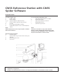
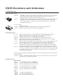
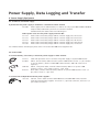
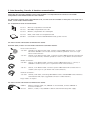
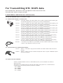
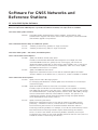
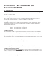
Equipment List For GNSS Networks and Reference Stations GNSS Reference Station with GNSS Spider Software Essential Items: For Data logging only: a - Power supply e - GNSS receiver f, g, h - optional radome, GNSS Antennas, i, j - Antenna cable, optional surge arrester k - CF Card o - PC running GNSS Spider software q - Cable GNSS receiver to PC or communication device For transmitting RTK/DGNSS data: l - Cable from GNSS receiver to modem m - Radio/GSM modem n - Cable from modem to antenna r - Radio/GSM antenna s optional surge arrestor Note: GNSS antenna has to be set up on pillar or fixture with 5/8 inch thread. Note: A mount is needed to set up radio antenna. Choice of radio modem may depend upon radio modems used by RTK/DGNSS rovers. GSM phone may be used instead of radio modem. Optional external devices: b - Interface cable c - optional DB9 surge arrester with 12V DC pass through d - Meteorological sensor d - Tilt sensor x x Regional and local Leica reference station support specialists will help you selecting the optimal equipment configuration. A support and maintenance contract is strongly recommended for all reference station systems. GNSS Receivers and Antennas 1. GNSS Receivers Select the GNSS receiver 766 730 766 733 GRX1200+, Triple Frequency GPS Reference Receiver, Professional, with Event Input, PPS Output, External Oscillator Input and Ethernet connectivity. Includes L2C. Requires separate software option for full time GPS L5. GRX1200+ GNSS, GPS/GLONASS/Galileo Triple Frequency Reference Station Receiver, Professional, with Event Input, PPS Output, Extern. Oscillator Input and Ethernet connectivity. Includes L2C. Requires separate software options for full time GPS L5/GLONASS and Galileo Can also be used 758 600 755 231 Monitoring receiver GMX902 GG, GNSS Dual Frequency Receiver for Monitoring Applications. GMX901, GPS Smart Antenna for Monitoring Applications Purchasable Options 751 225 766 734 768 855 6002845 752 215 752 216 755 277 GSW567, GLONASS option for GRX 1200 GG Pro and GRX1200+ GNSS Receiver. Without the GLONASS option, GLONASS is only enabled on Wednesdays. GSW684, Galileo option for the GRX1200+ GNSS Receiver. GSW707, GPS L5 option for the GRX1200+ GNSS and GRX1200+ Receiver. Multi-GNSS Signal Bundle for the GRX1200+ GNSS Receiver, consists of GLONASS option, Galileo option and the GPS L5 option. GSW578, FTP Push and RINEX option for GRX1200 Pro Series and GRX1200+ Series.For onboard RINEX conversion and scheduled FTP Push of raw data and RINEX files. GSW579, Campaign option for GRX1200 Series. Static raw data logging can be configured and started in the field with the RX1210 or RX1210T controller. Without this option, the GRX web interface or GNSS Spider are needed for raw data logging. GSW601, RTK Multiplexer Option GRX1200 Pro Series and GRX1200+ Series. Allows up to 10 rover connections from the LAN/WAN to an RTK Stream from a single sensor NET port. Without this option only one rover at a time can connect to a sensor NET port transmitting RTK corrections. The receivers types GX1210, GX1220, GX1230 require the following firmware option for operation with GNSS Spider: 737 643 GSW421, GPS1200 extended OWI/LB2 remote control: Allows full sensor steering and communication via OWI/LB2 commands. Extended warranty GMX 901/902 89332 1 year extended warranty for GMX902 GG 5301720 2 year extended warranty for GMX902 GG 5301721 add 1 year GMX902 GG Warranty Extension 5301722 5301723 5301724 1 year extended warranty for GMX901 2 year extended warranty for GMX901 add 1 year GMX901 Warranty Extension AR25 5302680 5302681 5302682 1 yr AR25 Extended Warranty 2 yr AR25 Extended Warranty add 1 yr AR25 Extended Warranty AT504 (GG) 5301706 1 yr AT504 (GG) Extended Warranty 5301707 2 yr AT504 (GG) Extended Warranty 5301708 add 1 yr AT504 (GG) Extended Warranty Receiver Conversion 758 420 766 735 GSW619, Receiver Upgrade from GRX1200 Pro to GRX1200 GG Pro incl. permanent GLONASS functionality. Note: This option is only available for GRX1200 Pro receivers with serial numbers between 355001 and 360000. No upgrade from GRX1200 Pro to GRX1200GG Pro is available for receivers outside of this range of serial numbers. For those receivers 766735 must be purchased to upgrade to GLONASS or other GNSS. GSW685 Receiver Upgrade from GRX1200+ to GRX1200+ GNSS. Note: For full time GLONASS, Galileo and GPS L5 functionality, the respective software options need to be ordered additionally. Note: Upgrades for non GRX1200+ receivers (i.e. GRX1200 Pro, GRX1200GG Pro) to GRX1200+ GNSS receivers need to be done by service. 2. GNSS Antennas Select the antenna for the receiver. Compact SmartTrack antennas are suitable for most geodetic applications. Choke ring antennas are for special applications, including high-precision geodetic surveying. All antennas have a 5/8 inch thread. For set-ups on carriers with stub, a screw-to-stub adapter is needed for the antenna. 2.1 Choke ring, geodetic antenna 765 733 755 267 667 140 765 734 AR25, GNSS choke ring antenna for GPS/GLONASS/Galileo/Compass receivers. Includes L-Band signals. Dorne-Margolin antenna element. AT504 GG, GPS/GLONASS dual-frequency choke-ring antenna for GPS/GLONASS receivers. Dorne-Margolin antenna element, JPL design. Conforms to IGS "Typ T" specification for GPS antennas. Weather-protection radome for AT504/AT504GG choke ring antenna. Weather-protection radome for AR25 GNSS choke ring antenna. 2.2 Compact SmartTrack, geodetic antennas 766 714 747 958 AX1203+ GNSS, GPS/GLONASS/Galileo Triple Frequency Antenna for all GRX1200 Series and GRX1200+ Series receivers. AX1202 GG, Dual Frequency GPS/GLONASS Antenna for GMX902, GX1220/1230 and GRX 1200 Series Receivers. 2.3 Screw-to-Stub Adapter for GNSS Antennas 667 217 Screw-to-stub adapter for fitting GPS antenna on carriers with stub and poles with stub. 3. Antenna Cables 3.1 Short and Medium Length Antenna Cables 667 667 724 636 632 200 201 969 959 372 1.2m antenna cable. 1.6m extension for antenna cable. 1.8m antenna cable. To be used for the balanced all-on-the-pole setup. 2.8 m antenna cable 10 m antenna cable 3.2 Extra Long Antenna Cables 632 390 30m antenna cable. 664 813 50m antenna cable.0 713 483 70m antenna cable. Longer antenna cables and signal amplifiers can be supplied on request. Power Supply, Data Logging and Transfer 4. Power Supply Equipment 4.1 Continuous 12V Power supply A permanent 12V power supply is needed for a reference-station receiver 722 409 Power-supply unit for GNSS receiver, for indoor use only, input 100V-240VAC 50-60HZ, output 12VDC, cable with 5-pin Lemo to connect to receiver. Standard mains/line cable select from following list. Select power cords for 12V power supply unit 722 409: 731 731 734 734 738 772 773 232 233 586 Power Power Power Power Power Cord Cord Cord Cord Cord for for for for for Dual Dual Dual Dual Dual Bay Bay Bay Bay Bay Charger Charger Charger Charger Charger GKL24 GKL24 GKL24 GKL24 GKL24 or Power or Power or Power or Power or Power supply supply supply supply supply unit, unit, unit, unit, unit, US-Version. EU-Version. UK-Version. AUS-Version. CH-Version. For suitable batteries and chargers please refer to the Leica GPS1200 Series equipment list. 4.2 Power Cables To connect battery, car battery or alternate power supply to GNSS receiver. 722 411 439 038 560 130 636 972 Cable with protection fuse to connect 12V power supply to System1200 receiver. GEV71, 4m car battery cable connects System 1200 receivers (Lemo-1, 5 pin, female) to 12V car battery. (Note: For GRX1200+ GNSS receivers, 560 130 or 636 972 is required.) GEV97, 1.8m power cable, connects external battery GEB171 to System 1200 receivers. Lemo-1, 5 pin, male to Lemo-1, 5 pin, male.. 0.5m cable, connects external battery GEB171 to System 1200 receivers. Lemo-1, 5 pin, male to Lemo-1, 5 pin, male. To connect two independent external power supplies: 733 298 GEV172, 2.8m Y-cable connects GRX1200 Series and GRX1200+ Series receivers with two external power supplies. One Leom-1, 5 pin male connector, two Lemo-1,5 pin female connectors. 5. Data Recording, Transfer & Receiver communication Select the data recording medium. The normal medium is a CompactFlash card. At least one 32 MB CompactFlash card will be needed for each receiver. For direct data transfer from CompactFlash cards, use the card slot available on many PCs. If no card slot is fitted, a card reader will be needed. 5.1 CompactFlash Cards and Card Reader 733 257 745 995 733 258 MCF256, CompactFlash card 256 MB MCF1000, CompactFlash card 1 GB MCFAD1, CompactFlash PC Card adapter 733 259 667 072 MCR5, Card reader for CompactFlash card Card reader for flash and SRAM PCMCIA cards, power from PC 5.2 Data Transfer and Receiver communication cables Essential cable, at least one should be ordered for each GNSS receiver. Direct serial connection: 733 280 733 282 GEV160, 2.8m Data transfer cable. Connects System1200 receiver Ports 1, 2 and 3, RX1220 or GMX902 to PC for data transfer, firmware upload etc. Lemo 8 to 9 pin RS232 serial connector. GEV162, 2.8m Data transfer cable. Connects System 1200 receiver RX Controller Port to PC for data transfer, firmware upload etc.. Lemo to 9 pin RS232 serial connector. Modem connection: 563 809 GEV113, 2.8m Modem cable. Connects System 1200 receiver Ports 1, 2 and 3, or GMX902 to modem (Lemo 8 pin to 9 pin RS232 male serial connector). 736 915 GEV191, 2.8m Modem cable. Connects System 1200 receiver RX Controller Port to modem (Lemo 8 pin to 9 pin RS232 male serial connector). Network connection: 733 290 GEV168, 5.0m cable, connecting GRX1200 Pro Series and GRX1200+ Series Receivers with Ethernet LAN / RJ45 (ruggedised connector to GNSS receiver). Longer cables on request. 5.3 Data Transfer and Antenna communication cables 750 073 743 389 GEV212, Interface Cable, 5m, GMX901 to unterminated, connects GMX901 to a custom installation. GEV197, Y-Cable, 2.8m, GMX901 to RS232 and external Leica power supply. For Transmitting RTK /DGPS data Use a suitable radio. The choice of radio may depend on radios used at rover units. Set up the radio antenna as high as possible. 6. Radio Modem, Radio Antennas and Accessories For use with GRX1200 Series for real-time or DGPS 6.1 Satelline Radio Modems and Accessories 733 275 733 276 738 272 738 273 738 274 738 275 738 276 753 928 756 623 639 968 GFU14-0, Satelline 3AS radio modem (433.525 MHz, 25.0 kHz channel spacing, 0.5 W) already integrated into housing, fits on side of GNSS Receiver. GFU14-1, Satelline 3AS radio modem (406.425 MHz, 25.0 kHz channel spacing, 1.0 W) already integrated into housing, fits on side of GNSS Receiver. GFU14-2, Satelline 3AS radio modem (445.000 MHz, 12.5 kHz channel spacing, 0.5 W) already integrated into housing, fits on side of GNSS Receiver. GFU14-3, Satelline 3AS radio modem (443.000 MHz, 12.5 kHz channel spacing, 0.5 W) already integrated into housing, fits on side of GNSS Receiver. GFU14-4, Satelline 3AS radio modem (440.550 MHz, 25.0 kHz channel spacing, 0.5 W) already integrated into housing, fits on side of GNSS Receiver. GFU14-5, Satelline 3AS radio modem (458.150 MHz, 12.5 kHz channel spacing, 0.5 W) already integrated into housing, fits on side of GNSS Receiver. GFU14-6, Satelline 3AS radio modem (439.8625 MHz, 12.5 kHz channel spacing, 1.0 W) already integrated into housing, fits on side of GNSS Receiver. GFU14-7, Satelline 3AS radio modem (464.5000 MHz, 25.0 kHz channel spacing, 1.0 W) already intergrated into housing, fits on side of GNSS Receiver GFU14-8, Satelline 3AS radio modem (458.6000 MHz, 25.0 kHz channel spacing, 0.5 W) already intergrated into housing, fits on side of GNSS Receiver. 1.8m Cable, 15 pin RS232 to 8 pin LEMO. Connects Satelline radio modem to GNSS receiver. Only required if housing not used. 6.1.1 Special cables for Satelline Radio Modem 733 297 762 026 GEV171, 1.8m cable to program the Satelline 3AS radio modem inside the GFU14 housing GEV221, Y-cable, connects Satelline 3AS Epic Pro radio to System 1200 GPS receiver and 12V car battery. 6.2 Pacific Crest Radio Modems Pacific Crest Radio Modems must be ordered directly from your local Pacific Crest Office or Representative. PDL receive only modems built into the Leica GFU radio housing with 12.5 or 25kHz channel spacing within the following frequency bands are available: 410 - 430MHz 430 - 450MHz 450 - 470MHz 223 - 235MHz 6.3 Gainflex Radio Antennas Select according to frequency of radio modem 639 964 667 243 Gainflex radio antenna, frequency range 400 – 435 MHz Gainflex radio antenna, frequency range 435 – 470 MHz 6.4 Antenna Cables Connecting Radio Modem to Gainflex Radio Antenna Note that the cables are the same as for GNSS antennas. 667 636 632 667 200 959 372 201 1.2m 2.8m 10 m 1.6m antenna cable. antenna cable. antenna cable extension for antenna cable. 6.5 GFU Connection Cable 733 288 GEV167, 0.5m, connects System 500 GFU housing to all System 1200 receivers 6.6 Modem Cables 563 809 736 915 2.8m Modem cable. Connects GPS1200 receiver Ports 1, 2 and 3 to modem (Lemo 8 Pin to RS232 9 Pin male). GEV191, 2.8m Modem cable. Connects GPS1200 receiver RX Controller Port to modem (Lemo 8 Pin to RS232 9 Pin male). 6.7 Accessories Needed to Set-up Gainflex Radio Antenna on Telescopic Rod 667 228 667 220 734 388 667 236 GAD32, Telescopic rod with 5/8 inch screw. Fits in minipack 667137. Fits in base 667236. GAD34, Arm 3cm long, screws on telescopic rod. Gainflex antenna fits on arm. Antenna cable connects to arm. GAD46, Double arm adapter, screws on telescopic rod. Allows to connect up to 2 mobile phone/radio antennas and up to 2 antenna cables on arm. GHT36, Base with 5/8 inch screw, for setting up telescopic rod on tripod. 7. Mobile Phones and Accessories 7.1 Mobile Phones 744 754 750 243 750 242 GFU19, US CDMA cellular phone Multitech MTMMC-C, integrated into housing, fits on side of System1200 receiver. GFU25, CDMA cellular phone for Canada, Multitech MTMMC-C-N12 for Bell Mobility network, integrated into housing, fits on side of System 1200 receiver. GFU24, Housing with Siemens MC75 GSM/GPRS Module (Quad-Band GSM 850/900/1800/1900 MHz), fits on side of System 1200 receiver 7.2 Antennas for Mobile Phones 760 557 667 237 734 756 GFU26, US CDMA cellular phone Multitech MTMMC-C-N14 for Alltel network, inte-grated into housing, fits on side of the System 1200 receiver or GHT56 for the SmartRover. GAT3, Antenna for 900/1800 MHz mobile network. GAT5, Antenna for US mobile network (800/1900MHz). Other Accessories 8. Receiver Firmware Maintenance 734 393 GSW380, One year maintenance for GPS1200 firmware and application software. A separate comprehensive support and maintenance contract for the complete Reference Station solution is strongly recommended. 9. Cables for pps output, event input, external frequency input 667 744 GEV150, PPS output cable for GRX1200Pro Series and GRX1200+ Series Receivers, 2m long, connects the receiver time mark output to another device with BNC connector. 403 448 GEV42, 2m cable, connects GRX1200Pro Series and GRX1200+ Series receiver event input to another device with BNC connector. 733 293 GEV169, 2.0m cable, connecting GRX1200Pro Series and GRX1200+ Series receiver with External Oscillator device. 10. To mount GNSS receiver Holder for fixed mounting of GNSS receiver. 742 005 GHT53, Holder for all System 1200 receivers. For attaching the receiver to wall bench, table. etc. 11. To set up GNSS Antenna Screw antenna directly onto a 5/8inch screw, or use tribrach + carrier. 11.1 Tribrachs Tribrach with optical plummet is needed for GRT144 and GRT146 carriers. Tribrach without optical plummet is needed for SNLL laser plummet carrier. 667 667 667 667 307 308 304 305 Tribrach Tribrach Tribrach Tribrach GDF122 GDF112 GDF121 GDF111 PRO, with optical plummet, pale green. BASIC, with optical plummet, pale green/red. PRO, without optical plummet, pale green. BASIC, without optical plummet, pale green/red. 11.2 Carriers The GRT146 carrier has a 5/8" screw. The GNSS antenna screws on directly. The GRT144 and SNLL carriers have a stub fitting. The GNSS antenna must be fitted with a screw-to-stub adapter for setting-up on these carriers. 667 216 667 313 667 316 GRT146 Carrier with 5/8 inch screw, GNSS antenna screws on directly. Carrier GRT144 for GPS antenna, EDM reflectors and target plates, pale green. SNLL121, Sensor nadir laser plummet, pale green, with user manual. 12. Controller Display and keyboard for GNSS receiver. Typically not needed for receiver connected to PC with GNSS Spider Software. The controller can connect directly to the GNSS receiver or can be connected using a cable. For GRX1200 and GRX1200 Pro the Controller allows receiver configuration and shows the receiver status, but cannot be used to operate the receiver for data logging or transmitting RTK. 733 260 RX1210T, System 1200 Controller with touch screen, alpha keyboard, 2 x GDZ56 pens for touch screen, user manual. Can be used as GPS1200 Controller or TPS1200 remote control (with ext. battery and ext. radio). 733 266 GHT41, Hand strap for RX1200 Series Controller with utility hook for attaching to belt or tripod. GEV163, 1.8m controller cable connecting RX1200 Controller series to all System 1200 receivers. GEV164, 1.0m cable, connecting the RX1200 Controller series to GNSS receiver. To be used for the balanced all-on-the-pole setup. 733 283 733 284 13. Transport Container 733 267 GVP623, Hard container for GX1210 / GX1220 / GX1230 and GRX1200 Receivers, AX1201 / AX1202 Antenna, RX1200 Controller series, cables and accessories Not needed for GRX1200+ or GRX1200+ GNSS at reference station. 14. External devices and accessories 14.1 Meteorology sensor Meteorology sensor for temperature, pressure and humidity with cable to GNSS receiver, on request.. 14.2 Tilt sensor 576 198 749 916 749 031 NIVEL210, inclination sensor with RS232 interface. GEV209, Cable, NIVEL 210 - GRX1200+ Series, 1.8m. GHT59, Wall mounting kit for NIVEL200. See also Equipment List “NIVEL210 and NIVEL220” Other tilt sensor with cable to GNSS receiver, on request. 14.3 Lightning protection device In line protection device, between GNSS antenna and receiver, on request. Please contact your local Leica Geosystems representative for recommended third party devices and accessories. Software for GNSS Networks and Reference Stations 15. Leica GNSS Spider Software Leica GNSS Spider makes use of the Microsoft SQL database. With Leica GNSS Spider the free version Microsoft SQL Server 2005 Express is provided and will be installed, if no SQL server is available. 15.1 Leica GNSS Spider Software 740 244 Leica GNSS Spider, GNSS Reference Station Software, general license, with documentation. Supports full receiver control and configuration, manual downloads and firmware upgrade. Not protected.. 15.2 Software Protection Keys for additional options 734 712 734 713 Software protection key (parallel) for single user licence. Software protection key (USB) for single user licence. 15.3 Leica GNSS Spider – Site Server, Protected Options 15.3.1 File Product Service Options 744 904 Spider, File Products Service (FPS) option. Provides automated data download and management for multiple sites with automated RINEX conversion, quality control, event logging, FTP transfer for distributing Spider product files on the Internet. Option includes one (1) site/sensor license. For more site/sensor licenses for a Spider FPS, order one or more "Spider, FPS Additional Site License" as required. 734 613 Spider, FPS Additional Site License. Required for each GNSS site/sensor that shall be used with Spider File Product Service in addition to the default one (1) site/sensor, which is included as standard. 15.3.2 Other Site Server Options 734 614 Spider, Event E-mail & Messaging Option. For managing and distribution of GNSS Spider event information via e-mail and/or network messaging. 744 908 Spider RT-Product Service for Site Server not related to site licences. Provides output of RTK data for all connected sites, that are capable of streaming their GNSS raw observation to the Site server. Supported real time message formats are standard RTCM (V2.x, V3.0) and proprietary formats (Leica, CMR, CMR+), through various communication channels (Serial, Modem or TCP/IP). This option is not required if RT-products shall be created and output through the Spider Network Server Advanced RT-Proxy Service (744915). 744 912 Spider, Positioning Site license. Required for each GNSS site/sensor that shall be used for the Spider position processing. A minimum of two (2) of these licenses is needed for Positioning. Note: Positioning Site Licences are cumulative between Real-Time and PostProcessing Positioning Products. For example, to use 10 sites simultaneously in both Real-Time and Post-Processing Products requires 20 Positioning Site Licences. There is no limit to the number of Positioning Products (baselines) that may be configured if the number of sites used (including reference and rover sites) does not exceed the number of Positioning Site Licences. 15.4 GNSS Spider - Network Server, protected Options 15.4.1 GNSS SpiderNET, Options for Network RTK 744 913 SpiderNET, Option for GPS Network RTK/DGPS. Provides real-time GPS network processing and error estimation with advanced network processing algorithm. A basic RT-Proxy server for real time network correction output, Leica MAX, in standard RTCM V3.1 (Network messages) format and individualised network RTK & DGPS corrections, Leica i-MAX, in standard (Leica, CMR, CMR+, RTCM V2.3, 3.0/3.1) baseline message formats. Supports various communication channels (Serial, Modem or TCP/IP). Includes support for up to five (5) sites to be assigned in network processing. For each additional site one "SpiderNET Additional Site License" (744914) is needed. 744 914 SpiderNET, Additional Site License. Required for each site that shall be assigned in SpiderNET Network server processing in addition to the default five (5) sites/sensors that are included in the "SpiderNET, Option for GPS Network RTK" (744913). 762 472 SpiderNET, GLONASS network processing extension. Provides real-time GLONASS network processing and error estimation with advanced network processing algorithm. Requires the "SpiderNET, Option for GPS Network RTK" (744913). 766 766 SpiderNET, Extension for legacy Network RTK methods. Provides in addition to MAX and i-MAX the following legacy methods for Network RTK: - FKP (Area Correction Parameters) - Virtual Reference Station Requires the "SpiderNET, Option for GPS Network RTK" (744913). 15.4.2 Other Network Server Options, not related to site licenses 744 915 Spider, Advanced RT-Proxy Service option. Provides advanced distribution of real time single site or network corrections with automatic nearest site or cell selection based on rover location. Includes also support for RTCM transformation data messages and Ntrip Caster&Server functionality. Supported real time formats are standard RTCM (V2.x, V3.x) or proprietary (Leica, CMR, CMR+) real time message formats, through various communication channels (Serial, Modem, Access Router or TCP/IP). Can be used with "SpiderNET, Option for Network RTK" (744913). Can also be used with GNSS Spider Site server, instead of "Spider, RT-Product Service" (744908). 744 916 Spider Business Center Option. For advanced real-time user management with authentication, authorisation and accounting support, plus real time user auditing and creation of user activity logs. Can be used together with "SpiderNET, Option for Network RTK" (744913) or "Advanced RT-Proxy Service Option" (744915). Recommended option if Advanced RT-Proxy Server Ntrip Caster functionality is used. 744 917 Spider, Re-Processing. Provides full re-processing functionality for GNSS Spider (Site server) and SpiderNET (Network server) from raw RINEX or Leica binary raw data files (simulated sites). This option does not require any of the other GNSS Spider protected options. 15.5 Leica GNSS Spider Upgrades 734 616 GNSS Spider Site Server Upgrade from ControlStation. Full upgrade from existing ControlStation licence. Includes GNSS Spider Site Server File Product Service option with one site licence. 734 617 GNSS Spider Site Server Upgrade from CRNet Lite. Full upgrade from existing CRNet Lite licence. Includes already purchased number of CRNet site licences, GNSS Spider Site Server File Product Service and Event E-mail & Messaging options. 16. Leica GNSS QC Software Leica GNSS QC is a stand-alone software for quality control and analysis of GNSS reference station data. It may run alongside Leica GNSS Spider or other reference station software. A hardware protection key must be ordered separately. 16.1. Leica GNSS QC Software 749 319 Leica GNSS QC, GNSS Reference Station software with documentation. For data analysis and quality control of GNSS reference station data. Dongle protected. 16.2 Leica GNSS QC Options 751 824 GNSS QC, Advanced Coordinate Analysis option. High speed calculation and graphing of displacement, messaging and limit checks for real time NMEA and GNSS Spider Post Processing coordinate data. Dongle protected. 762826 GSW624, GNSS QC, Advanced Network Analysis option. For analysis of ionosphere and troposphere error from a GNSS Spider Network. Dongle protected. Requires Leica GNSS Spider v3.0 or later with Network RTK. This option only works together with Leica GNSS Spider v.3.0 or later with 744 913 SpiderNet option 759 039 GSW623, GNSS QC, Advanced Data Analysis option. Zero, single, double and triple difference residual analysis of GNSS code and phase data. Dongle protected. 749 320 GNSS QC, Automatic Quality Check option.. Automatic processing of data from a GNSS reference station network including web page generation, graphs, reports and email messaging. Includes one site licence. Dongle protected. 749 321 GNSS QC, Additional site license for Automatic Processing option. Up to 256 additional site licences may be configured. Dongle protected. 17. Leica SpiderWeb Software Leica SpiderWeb is a web-server-based advanced solution for convenient distribution of GNSS reference data over the Internet. A hardware protection key must be ordered separately. 17.1. Leica SpiderWeb Software 751 352 Leica SpiderWeb Basic License, Software with documentation. Without protection key runs as Lite version to support full web server configuration, site management and data access via link to a FTP server. Without user access management. 17.2 Leica SpiderWeb Protected Options 764 662 SpiderWeb, RINEX Job Service. Enables automated, user specific and job based RINEX Service. Includes advanced user management and one (1) SpiderWeb site license. For more site licenses order one or more 751353 "Leica SpiderWeb additional site license" as required. 751 353 Leica SpiderWeb additional site license. Required for each additional site that shall be used with 764662 "SpiderWeb, RINEX Job service" option in addition to the default one (1) site, which is included. 764 663 SpiderWeb, Extension for Virtual RINEX. Enables creation of Virtual RINEX data based on a GNSS Spider network procsessing solution. Requires 764662 "SpiderWeb, RINEX Job service" option. 755 125 Leica SpiderWeb GNSS QC Option. Recommended with 764662 "SpiderWeb, RINEX Job service" option. Requires following GNSS QC Options on same software protection key: - 749319 Leica GNSS QC Software with documentation. - 749320 GNSS QC, Automatic Processing option. 1x per each SpiderWeb Site: - 749321 GNSS QC, Additional site license. 755 126 Leica SpiderWeb Option for automated Coordinate Computation Service. Requires 764662 "SpiderWeb, RINEX Job service" option. Requires also the following LGO Options on same software protection key: - 734719 L1/L2 data-processing for GPS - 734720 RINEX Import for GPS - 734725 Design & Adjustment 3D Following LGO options can also be added: - 752697 Glonass data-processing for LGO, protected option. Can only be ordered in addition to L1/L2 data-processing option for GPS (734719) - 734724 Datum & Map transformation, protected option. Services for GNSS Networks and Reference Stations 18. Leica CrossCheck Leica CrossCheck is a web based service for GPS/GNSS reference network coordinate calculation, integrity monitoring and deformation monitoring. Two types of services are offered: • Single Computation Service • Monitoring Service In both services, engineers from Leica Geosystems use the Bernese GPS Software v5.0 (or later) to process the customer's data. The processing strategy is optimized to provide highest possible accuracy. 18.1. Single Computation Service The Single Computation Service enables customers to obtain high accuracy coordinates for their reference station network without the need to invest in specialist GNSS processing expertise, software or IT infrastructure. The site coordinates are computed in the customer's chosen datum. A PDF report with site coordinates and accuracies is provided via email to the customer. The Single Computation Service consists of a base fee and a per site fee. 5002093 CrossCheck Coordinate Service Base Fee 5002076 CrossCheck Coordinate Service Site Fee 18.2. Monitoring Service The Monitoring Service provides for detection and warning of antenna movements in near real time for networks of GNSS reference stations or monitoring sites. Site coordinates are calculated at a user defined interval. The solution is tailored to the needs of the customers network/project, including the processing interval, processing strategy, coordinate datum, limit checks and content of the secure online web service. An email messaging service is offered to provide warning when a significant movement occurs. The Monitoring Service consists of a one-time setup fee and then a quarterly subscription comprised of a base fee and a per site fee. 5002094 CrossCheck Monitoring Setup Fee 5302771 CrossCheck Quarterly Subscription Base Fee 5302772 CrossCheck Quarterly Subscription Per Site 5002120 Administration Fee 18.3. Invoicing The initial setup fee will be invoiced after sending the entitlement number (see below) The Single Computation Service will be invoiced once the service has been completed The Monitoring Service will be invoiced quarterly at the end of the period, if not cancelled (see below) 18.4. Monitoring Service Change Requests The amount of Quarterly Subscription Per Site of the Leica CrossCheck Monitoring Service can be changed at a month’s notice for the next billing period. An administration fee (Article 5002120) is incurred each time the number of points is increased or decreased. 18.5. Cancellation The Leica CrossCheck Monitoring Service can be cancelled with a month’s notice for the next quarter. The cancellation notice must be given in written form. 19. Product Maintenance, Support & Service A powerful and competent worldwide service and support network backs up Leica Geosystems Networked Reference Station solutions. Leica Geosystems' customers benefit from service and support that spans time zones and geography. Our Active Customer Care program has packages to suit your needs, whether you use our simplest distance measuring device or the most sophisticated integrated solution. Active Customer Care is a true partnership – it's our commitment to continue to provide the level of support and collaboration you have come to expect when you put your trust in Leica Geosystems. True Global Coverage Leica Geosystems has the most comprehensive service and support network in the world. 128 authorized Support & Service Centers Offices and Dealers covering every continent Customer Support and Information Hot Lines Transportation options to suit the most time critical requirements Flexibility to meet your needs Our range of service and support packages ensure we can satisfy your requirements. Service Levels range from routine maintenance to support for mission critical applications Web based service and support, allowing you to access our support organization when it suits you First Class Training = First Class Productivity Get your team up to speed with: Scheduled Training Courses Informative Seminars and Web Broadcasts Customized Training Courses Consultancy Services Keep your Equipment up to date and in Top Condition Technical Service Repair All inclusive maintenance contracts Hardware and Software upgrades Because a true partnership delivers maximum productivity Since 1921, Leica Geosystems' customers have trusted us to provide the most reliable, innovative, robust measuring solutions. Most importantly, these customers continue to work with Leica Geosystems because we provide truly exceptional support and service anywhere around the globe. We help their employees get up to speed, we support them during their learning curve and we make sure that their equipment is in top condition. The Active Customer Care program brings this tradition of high quality support to a new level. Whether Whether Whetherproviding providing providingcorrections corrections correctionsfrom from fromjust just justaaasingle single singlereference reference referencestation, station, station, or or oran an anextensive extensive extensiverange range rangeof of ofservices services servicesfrom from fromaaanationwide nationwide nationwideRTK RTK RTKnetwork network network––– innovative innovative innovativereference reference referencestation station stationsolutions solutions solutionsfrom from fromLeica Leica LeicaGeosystems Geosystems Geosystemsoffer offer offer tailor-made tailor-made tailor-madeyet yet yetscalable scalable scalablesystems, systems, systems,designed designed designedfor for forminimum minimum minimumoperator operator operator interaction interaction interactionwhilst whilst whilstproviding providing providingmaximum maximum maximumuser user userbenefit. benefit. benefit.In InInfull full fullcompliance compliance compliance with with withinternational international internationalstandards, standards, standards,Leica's Leica's Leica'sproven proven provenand and andreliable reliable reliablesolutions solutions solutionsare are are based based basedon on onthe the thelatest latest latesttechnology. technology. technology. Precision, Precision, Precision,value, value, value,and and andservice service servicefrom from fromLeica Leica LeicaGeosystems. Geosystems. Geosystems. When When Whenititithas has hasto to tobe be beright. right. right. Illustrations, Illustrations, Illustrations, descriptions descriptions descriptions and and and technical technical technical specifications specifications specifications are are are not not not binding binding binding and and and may may may change. change. change. Printed Printed Printed ininin Switzerland Switzerland Switzerland ––Copyright –Copyright Copyright Leica Leica Leica Geosystems Geosystems Geosystems AG, AG, AG, Heerbrugg, Heerbrugg, Heerbrugg, Switzerland, Switzerland, Switzerland, 200(. 200(. 200(. 745972en 745972en 745972en ––II.0( –II.0( II.0( ––aeP –aeP aeP Leica Leica LeicaGeosystems Geosystems GeosystemsAG AG AG Heerbrugg, Heerbrugg, Heerbrugg, Switzerland Switzerland Switzerland www.leica-geosystems.com www.leica-geosystems.com www.leica-geosystems.com