1
Apollo AirMap - draft
APOLLO AIRMAP APOLLO SOFTWARE 2006
1
Copyright
APOLLO Software 2006
Content
Introduction ............................................................................................................................................................. 1
Installation, Deinstallation, Systemrequirements.................................................................................................. 1
Functions ................................................................................................................................................................ 4
Correction of Coordinates ....................................................................................................................................14
GigaMap.ini File................................................................................................................................................17
Airport Charts....................................................................................................................................................18
G1000 und FSX....................................................................................................................................................19
License Manager..................................................................................................................................................19
APOLLO SOFTWARE LICENSE AGREEMENT .............................................................................................. 21
List of Figures
Fig. 1 Apollo AirMap Panel Configurator............................................................................................................... 2
Fig. 2 Panel Installation dialog part 1 .................................................................................................................... 3
Fig. 3 Panel Installation dialog part 2 .................................................................................................................... 4
Fig. 4 Display of the flight plan.............................................................................................................................. 6
Fig. 5 Same as Fig. 22 but with track up.............................................................................................................. 7
Fig. 6 Small (left) and long (right) track arrow ...................................................................................................... 8
Fig. 7 GARMIN 500 view ....................................................................................................................................... 9
Fig 8 Apollo AirMap with large map view ............................................................................................................10
Fig 9 Apollo AirMap resized to small instrument without scale mode active (left) and with scale mode active
(right) .....................................................................................................................................................................10
Fig. 10 TCAS Mode..............................................................................................................................................11
Fig. 11 ATC-Radar Mode....................................................................................................................................12
Fig. 12 State line at the top .................................................................................................................................13
Fig. 13 Display of pixel coordinates and the map in use....................................................................................15
Fig. 14 Instrument with border .............................................................................................................................16
Fig. 15 Instrument with hidden border.................................................................................................................16
Fig. 16 Boeing cockpit with small Apollo AirMap-Panel .....................................................................................17
Fig. 17 GARMIN 1000 and APOLLO AirMap with FSX.....................................................................................19
APOLLO AIRMAP APOLLO SOFTWARE 2006
2
Introduction
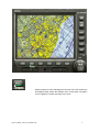
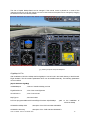
Apollo AirMap is a moving map for Microsoft Flightsimulator using aeronautical and geographic maps.
The full functionality of Microsoft Garmin GPS500 is also available with this instrument. Apollo AirMap can
be used with every aircraft of the Microsoft Flightsimulator. For the FSX Apollo AirMap comes with a
replacement for the Garmin 1000.
The following products are available:
APOLLO AirMap Germany ICAO
-
APOLLO AirMap Germany Topo
ICAO map for Germany
-
topographic maps for Germany
APOLLO AirMap Austria ICAO
-
ICAO map for Austria
APOLLO AirMap Austria Topo
-
topographic maps for Austria
APOLLO AirMap Swiss ICAO
-
ICAO map for Switzerland
APOLLO AirMap Swiss Topo
-
topographic maps for Switzerland
APOLLO AirMap German Airports
-
German airports
APOLLO AirMap USA East
-
US sectionals east coast
APOLLO AirMap USA Center
-
US sectionals midwest
APOLLO AirMap USA West
-
US sectionals west
In preparation:
Installation, Deinstallation, Systemrequirements
IBM PC with Pentium III 1 Ghz
512 MByte Memory (1 GByte suggested)
110 MByte 7 Gbyte free space on harddisk (depends on number of installed maps)
Windows95, Windows98, Windows2000 or Windows XP
DirectX Version 7.0 or above
DVD drive
FS2002, FS2004, or FSX
To install Apollo AirMap the program setup.exe must be run from the DVD (or download version). The
maps of Apollo AirMap can but must not be installed on the same logical drive on which the Flightsimulator
is installed. During installation you can select the number of maps you want to install. If you want to install
additonal maps afterward you simply start the program setup.exe. To deinstall the program you have again
to start setup.exe.
Integration of Apollo AirMap into a panel of an aircraft
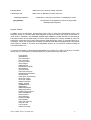
At the end of installation Apollo AirMap can be added to one or more aircraft. This will be done with the
program AirMapPanelConfigurator:
APOLLO AIRMAP APOLLO SOFTWARE 2006
1
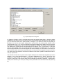
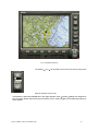
Fig. 1 Apollo AirMap Panel Configurator
An [G500] or [G1000] in front of the aircraft name shows that Apollo AirMap G500 or G1000 is already
integrated into the panel of the aircraft. With help of the mouse and the buttons Deselect all , and Select all
you can select the aircraft which panels should be changed. If you select an aircraft with an [G500] or
[G1000] in front of the name Apollo AirMap will be removed from the panel.cfg after selection of the
Remove button. If an [ ] is in front of the selected aircraft Apollo AirMap will be added to the panel.cfg after
the selection of Add . If there is an error during this operation a message will be shown in the status line.
The detailed error message will then be displayed after the selection of the Log File button. On the right
side the actual installed version of the Flight Simulator are displayed. The radio buttons can be used to
select the Flight Simulator which shall be equiped with APOLLO AirMap. The radio buttons on the lower part
of the panel are used to select which instrument (G500 or G1000) should be integrated. The option G1000 is
only visible if the FSX is detected. The APOLLO G1000 cannot be used in parallel to the Microsoft G1000. It
is only an replacement.
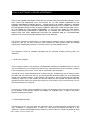
If an aircraft has more than one panel version Apollo AirMap can be automatically integrated only into the
panel.cfg in the main panel-subdirectory. In all other subdirectories (e.g. panel.1, panel.2 etc.) the
integration of Apollo AirMap can be done individually by selection of the Panel selection button. After
selection of this button a file selection dialog with all selectable aircraft will be displayed. To install Apollo
AirMap to the aircraft of your choice you must go to the panel folder of the aircraft and select the panel.cfg
file:
APOLLO AIRMAP APOLLO SOFTWARE 2006
2
Fig. 2 Panel Installation dialog part 1
APOLLO AIRMAP APOLLO SOFTWARE 2006
3
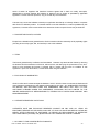
Fig. 3 Panel Installation dialog part 2
After selection of the Open-button Apollo AirMap will be integrated to the panel.cfg file of the selected
aircraft.
During this action the selected aircraft must not be loaded in the Flightsimulator because the panel.cfg file
may be locked! After integration of Apollo AirMap the aircraft can be selected from the Flightsimulator menu.
The same caution must be obeyed during the removal of Apollo AirMap from a panel.
If at the end of installation no aircraft has been instrumented with Apollo AirMap this can be done later by
starting Apollo AirMapPanelConfigurator.exe in subdirectory Apollo AirMap\System or from the Apollo
AirMap menu.
Functions
After integration of Apollo AirMap to the panel of the aircraft of your choice, you can start using it. If your
aircraft is within the vincinity of a map then the corresponding part of the map will be displayed. If you are
out of the boundaries of a map then the background may be black or white and black.
The moving map can be controlled by buttons on the instrument:
With this button different maps of the same region can be selected. If Apollo AirMap
Germany is installed it is possible to toggle between the ICAO, TK200, TK500, and the TK1000 map. If the
US version of Apollo AirMap is installed it is possible to toggle between the sectional and the Terminal Area
Chart if you are within the area of a Terminal Area Chart.
With this button the route of a loaded flightplan can be displayed.
APOLLO AIRMAP APOLLO SOFTWARE 2006
4
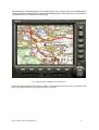
Fig. 4 Display of the flight plan
After pushing this button the internal coordinates of the aircraft and the
name of the map in use are displayed at the top of the screen. This
function can be used to correct local discplacements of the map (see
chapter Correction of Coordinates).
With this button the map can be rotated so that north or track is up. Track
up means that the nose of the aircraft will always point to the upper border
of the instrument and the map will be rotated.
APOLLO AIRMAP APOLLO SOFTWARE 2006
5
Fig. 5 Same as Fig. 22 but with track up
With this button an arrow extending from the nose of the own aircraft can
be displayed which shows the direction of the current track. The button
can be toggeled to increase the length of the arrow.
APOLLO AIRMAP APOLLO SOFTWARE 2006
6
Fig. 6 Small (left) and long (right) track arrow
This button can be used to switch off Apollo AirMap.
This button can be used to toggle the display between the Microsoft
GARMIN 500 and Apollo AirMap view.
APOLLO AIRMAP APOLLO SOFTWARE 2006
7
Fig. 7 GARMIN 500 view
With this button the scale mode can be activated/deactivated. In scale
mode the scale of the map will be changed if the size of the instrument is
changed.
If scale mode is not active and the size of the instrument is changed then
the scale of the map will not change. If the instrument will be changed to a
small size, the map view will also be small. If the instrument will be
changed to a large size, the map view will show a large part of the map.
If scale mode is active then the map view will nearly show the same part of
the map when the instrument is resized. If the instrument is resized so that
it is small, then the map view will also resized so that nearly the same part
of the map is shown. If the instrument will be resized to a large window
then the the map view will also be inlarged so that nearly the same part of
the map is displayed. In scale mode the part of the map which is shown
will be the same if the proportion of width and hight are retained during the
resize of the instrument. This means the map will never be distorted.
APOLLO AIRMAP APOLLO SOFTWARE 2006
8
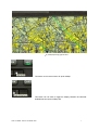
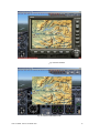
Fig 8 Apollo AirMap with large map view
Fig 9 Apollo AirMap resized to small instrument without scale mode active (left) and with scale mode active (right)
APOLLO AIRMAP APOLLO SOFTWARE 2006
9
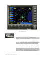
With this button the TCAS and ATC-radar mode can be
activated/deactivated. The first push of this button activates the TCAS
mode. In this mode all AI-aircraft in the altitude range 1500 feet above and
below the own aircraft will be displayed in different color depending on
there distance and closure rate. Aircraft which are nearest and have the
highest closure rate will be displayed in red. Aircraft which a more distant
will be displayed in yellow. All other aircraft will be displayed in white. An
arrow alongside displays the relative movement (up or down) and a
numeric label at the aircraft displays the altitude seperation in units of 100
feet. E.g. a 12 alongside means that the AI-aircraft is 1200 feet above the
own aircraft.
A second push on this button activates the ATC-radar mode. In this mode
all AI-aircraft within 60 NM are displayed. Alongside of each aircraft a label
shows the call sign, the speed, and the altitude of the aircraft. A green
arrow at each aircraft displays the actual heading. A third push on this
button will deactived the ATC-radar and the TCAS mode.
In multiplayer mode the AI-aircrafts are replaced by the multiplayer aircraft:
Fig. 10 TCAS Mode
APOLLO AIRMAP APOLLO SOFTWARE 2006
10
Fig. 11 ATC-Radar Mode
With this button the color of the flightplan and the aircraft can be toggled. If
a flightplan is active and displayed as an overlay line on the map this
button can be used to toggle the color of the flightplan. If the flightplan is
not displayed on the map the button can be used to toggle the color of the
aircraft.
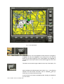
This button can be used to toggle a state line at the top of the display. The
state line displays the selected options and modes. In Fig. 12 the following
selections are used: Mode ATC-radar, zoom 8, orientation track up ,
scaled map, and map is sectional Chicago.
A second push on this button will display speed, heading, and altitude of
our own aircraft:
APOLLO AIRMAP APOLLO SOFTWARE 2006
11
Fig. 12 State line at the top
The buttons
and
can be used to zoom into and out of the map (some
maps do not allow a zoom out).
If the buttons of Microsoft GARMIN 500 in the Flight Simulator menu Controls Settings are assigned to
keys or joystick buttons then these keys and buttons can be used to trigger the corresponding buttons of
Apollo AirMap.
APOLLO AIRMAP APOLLO SOFTWARE 2006
12
Correction of Coordinates
In some maps the airports and runway symbols are not drawn to scale. Therefore the position of these
symbols may be incorrect compared to the position in Flight Simulator. If this is the case the runway
position in Flight Simulator and in Apollo AirMap may differ. This difference can be corrected by a local
adjustment.
In subdirectory Apollo AirMap\System is a file named offsets.txt. This file contains already corrections for
several airports/runways. This file can be edited with every text editor (e.g. wordpad). You have to obey
same rules if you want to add your own corrections to this file. In the following a part from this file is shown:
[DTK2\GERMANY]
52 33.47 13 16.02 6 -3 5
53 37.53 10 0.01 6 3 0
// Berlin Tegel EDDT 8L
// Hamburg EDDH
[Europe\GERMANY]
//ICAO
// Germany
53 47.03 7 55.00 3 -11 -2
54 22.91 10 9.26 3 1 7
// Wangerooge EDWG 10
// Kiel EDHK 26
[USA\New_YORK]
40 38.90 -73 45.90 12 -3 -21
// New York KJFK 22R
[USA\Miami]
If you push the coordinates button the path to the map in use will be displayed together with the actual
internal coordinates. The displayed path is a reference to the file offset.txt, e.g. USA\NEW_YORK is the
reference to the entry [USA\NEW_YORK] for the sectional of New York. All entries after this reference until
the next reference in square brackets belong to the New York sectional.
All entries have the same structure (example New York KJFK 22R):
Geographic latitude in degree and minutes (40 38.90)
Geographic longitude in degree and minutes (-73 45.90)
Radius in minutes (12)
Offset in X (-3)
Offset in Y (-21)
All data are for New York KJFK 22R and have the following meaning. Within an circle with a radius of 12
minutes around the center 40° 38.9 , -73° 45.9 all coordinates of the map shall be corrected by 3 units in
the X direction and 21 units in the Y direction. This correction brings the position of the runway 22R in the
map and in the Flight Simulator to a close match. Without this correction the aircraft will not be located on
the runway in the map if it is in Flight Simulator.
The values for this correction can be determined by placing the aircraft on the runway in the Flightsimulator
and determing the geographic position (display in Flight Simulator with shift + Z). These coordinate values
must be entered into the offset.txt file. Then the coordinates button of Apollo AirMap must be pushed. The
actual internal offset coordinates (0,0) will be displayed in the upper left corner of Apollo AirMap. Now you
can move the aircraft in the slew mode until the aircraft is exactly on the runway on the map. Now you can
read the internal offset position from the Apollo AirMap display and you can write them to the offset.txt file.
The value of 12 for the radius of the region around the runway is only an example. You can use a smaller
or larger value. The idea of this region is that the coordinate correction is applied at the center of this region
and will decrease with increasing distance from the center. At the border of the region the correction will be
vanish.
APOLLO AIRMAP APOLLO SOFTWARE 2006
13
After modification of the offset.txt file you must save this file. Then you have push the coordinates button
again to reaload the offset.txt. Now the aircraft will be displayed at the corrected position. If the position is
not satisfactory you can repeat the procedure again.
Fig. 13 Display of pixel coordinates and the map in use
The border of the instrument can be shown / hidden. To hide the border you must click on the center of the
map. In this region the mouse cursor will have the form of a hand:
APOLLO AIRMAP APOLLO SOFTWARE 2006
14
Fig. 14 Instrument with border
Fig. 15 Instrument with hidden border
APOLLO AIRMAP APOLLO SOFTWARE 2006
15
The size of Apollo AirMap-Panel can be changed. If the mouse cursor is placed on a corner of the
instrument border the cursor will change to an arrow. Now the size of the panel can be changed by dragging
the window corner to the desired position:
Fig. 16 Boeing cockpit with small Apollo AirMap-Panel
GigaMap.ini File
After installation of APOLLO AirMap the file GigaMap.ini can be found in the install directory of the Microsoft
Flight simulator. This file contains parameters which can be modified manually. The following parameters
can be modified:
[Apollo Software GigaMap]
InstalledMaps=2
;number of installed AirMap products
FlightPlanColor=3
;color of the actual flightroute
AircraftColor=0
;color of own aircraft
MapType=9
;last chart loaded
PATH=e:\\programme\Microsoft Games\Flight Simulator 9\Apollo\Maps
;path to the installation of
APOLLO AirMap
GIGAMAP2=AirMap USA
;description of the DVD with label GIGAMAP2
GIGAMAP1=Germany
;description of the DVD with label GIGAMAP1
APOLLO AIRMAP APOLLO SOFTWARE 2006
16
FrameUpdate=4
;update rate of the APOLLO AirMap instrument
TrafficRange=100
;radius within AI /Multiplayer aircrafts are shown
AIMultiplayerUpdate=5
:update rate for changes in the position of AI/Multiplayer aircraft
[GoogleEarth]
;all parameters for GoogleEarth should be changed within
thAirMapPanelconfigurator
Airport Charts
In addition to the US Sectionals, Terminal Area Charts (TAC), or ICAO and Topographical charts in the
European version you can also select airport diagrams via the CHRT button (left or right mouse button to
move forward - backward). This will display detailed airport diagrams including taxiways to make taxiing at
busy airports easier and to avoid runway incursions. Airport diagrams are currently available for all 32 US
Class Bravo airports and at the Class Charlie airport of KCMI Champaign, Illinois, in memoriam BAO Ltd. of
Champaign - Illinois, the company that "invented" what became later Microsoft Flightsimulator. More airport
charts might be added in the future as downloadable add-ons on the APOLLO Software website at
www.apollosoftware.com
To change the orientation of the display between NORTH UP, TRACK UP or TEXT UP (TEXT UP for easier
reading, only for charts that are not already NORTH UP by default) press the TRK button.
KATL-Atlanta
KBOS-Boston
KCLE-Cleveland
KCLT-Charlotte
KCVG-Cincinnati
KDAY-Dayton
KDEN-Denver
KDFW-Dalls Ft.Worth
KDTW-Detroit
PHNL-Honolulu
KSFO-San Francisco
KIAD-Washington-Dulles
KIAH-Houston
KJFK_New York Kennedy
KLAS-Las Vegas
KLAX-Los Angeles
KMCI-Kansas City
KMCO_Orlando
KMEM-Memphis
KMIA-Miami
KMSP-Minneapolis
KMSY-New Orlens
KORD-Chicago O'Hare
KPHL-Philadelphia
KPHX-Phoenix
KPIT-Pittsburgh
KSAN-San Diego
KSEA-Seattle
KSLC-Salt Lake City
KSTL-St.Louis
KTPA-Tampa
PANC-Anchorage
APOLLO AIRMAP APOLLO SOFTWARE 2006
17
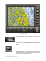
G1000 und FSX
The FSX comes with a new version of the GARMIN GPS: the G1000. APOLLO AirMap comes with a
special version of the G1000. The APOLLO AirMap for the G1000 has the same functions as the G500
with one exception. The instrument border cannot be hidden.
Fig. 17 GARMIN 1000 and APOLLO AirMap with FSX
Note
Information on new maps, updates, new documentation, downloads, and news on Apollo AirMap can be
found at the Apollo website:
http://www.apollosoftware.com
APOLLO AIRMAP APOLLO SOFTWARE 2006
18
APOLLO SOFTWARE LICENSE AGREEMENT
APOLLO SOFTWARE PUBLISHING IS WILLING TO LICENSE THE ENCLOSED SOFTWARE TO YOU
ONLY UPON THE CONDITION THAT YOU ACCEPT ALL OF THE TERMS CONTAINED IN THE
LICENSE AGREEMENT PRINTED BELOW. PLEASE READ THE TERMS CAREFULLY BEFORE
OPENING THE PACKAGE CONTAINING THE DISKETTE(S)/CD-R(S) OR CLICKING THE ACCEPT
BUTTON DURING INSTALLATION, AS SUCH CONDUCT INDICATES YOUR ACCEPTANCE TO ALL
OF THE TERMS OF THIS LICENSE AGREEMENT. IF YOU DO NOT AGREE TO THE TERMS,
APOLLO SOFTWARE PUBLISHING IS UNWILLING TO LICENSE THE SOFTWARE TO YOU, IN
WHICH CASE YOU MUST IMMEDIATELY RETURN THE PACKAGE AND ALL ACCOMPANYING
MATERIAL TO YOUR AUTHORIZED DEALER FOR A FULL REFUND.
This License Agreement ("Agreement") is a legal agreement between APOLLO Software Publishing
("APOLLO"), and you, the user ("Licensee"), and is effective the date Licensee opens the package
containing the diskette(s)/CD-R(s)/DVD or otherwise uses the enclosed software product.
This Agreement covers all materials associated with the enclosed software product (herein, the
"Software").
1. GRANT OF LICENSE
APOLLO grants Licensee a non-exclusive, non-transferable, personal and worldwide license to use one
copy of the Software on one computer only and one copy of the associated user documentation contained
in the accompanying user manual, "online" help or Acrobat files ("Documentation").
This license is for a single individual and not an entire company. Software may only be used for private,
non-public and non-commercial use only. The license granted hereunder applies only to the designated
version of the enclosed Software. If the Software is an upgrade, it, and the product that was upgraded,
constitute a single copy of the Software for purposes hereof and the upgrade and product that was
upgraded cannot be used by two people at the same time. This product is not for commercial use, only for
private entertainment on a single PC.
Licensee may not modify or alter the Software or remove any identifying string or copyright notice produced
by the Software. If the enclosed Software is packaged "For Evaluation Only," no right to copy and/or
distribute the Software is granted.
2. OTHER RESTRICTIONS
Licensee may not use, copy, rent, lease, sell, sublicense, assign or otherwise transfer the Software or any
copy, modification, or merged portion, in whole or in part, except as expressly provided for in this
Agreement. Licensee acknowledges that the Software, in source code form, remains a confidential trade
APOLLO AIRMAP APOLLO SOFTWARE 2006
19
secret of and/or its suppliers and therefore Licensee agrees that it shall not modify, decompile,
disassemble or reverse engineer the Software or attempt to do so except as permitted by applicable
legislation. Licensee shall not reproduce, copy or transfer any Documentation.
Licensee may not use the Software to develop an application that directly or indirectly utilizes or competes
with APOLLO's software product. If Licensee wishes to use the Software in a manner prohibited by this
Agreement, Licensee should contact APOLLO to determine whether a special license may be obtained.
3. PROPRIETARY RIGHTS; NOTICES
Except for the limited license granted herein, APOLLO retains exclusive ownership of all proprietary rights
(including all ownership rights, title, and interest) in and to the Software.
4. TERM
The license granted hereby is effective until terminated. Licensee may terminate the license by returning
the Software and Documentation to APOLLO, without refund, and destroying all copies thereof in any form.
APOLLO may terminate the license if Licensee fails to comply with any term or condition of this
Agreement. Upon such termination, Licensee shall cease using the Software.
5. EXCLUSION OF WARRANTIES
APOLLO offers and Licensee accepts the Software "AS IS." APOLLO does not warrant the Software will
meet Licensee's requirements or will operate uninterrupted or error-free. ALL WARRANTIES, EXPRESS
OR IMPLIED, ARE EXCLUDED FROM THIS AGREEMENT AND SHALL NOT APPLY TO ANY
SOFTWARE LICENSED UNDER THIS AGREEMENT, INCLUDING, BUT NOT LIMITED TO, THE
IMPLIED WARRANTIES OF MERCHANTABILITY, FITNESS FOR A PARTICULAR PURPOSE AND
NONINFRINGEMENT.
6. LICENSEE'S REMEDIES: LIMITATIONS
LICENSEE'S SOLE AND EXCLUSIVE REMEDIES AGAINST ON ANY AND ALL LEGAL OR
EQUITABLE THEORIES OF RECOVERY SHALL BE, AT APOLLO'S SOLE DISCRETION, WITHIN SIX
MONTH AFTER PURCHASE OF SOFTWARE, (A) REPAIR OR REPLACEMENT OF DEFECTIVE
SOFTWARE MEDIA (CD-ROM); OR (B) REFUND OF THE LICENSE FEE PAID BY LICENSEE.
7. NO LIABILITY FOR CONSEQUENTIAL DAMAGES
APOLLO AIRMAP APOLLO SOFTWARE 2006
20
In no event shall APOLLO or its suppliers be liable for any damages whatsoever (including, without
limitation, damages for loss of business profits, business interruption, loss of business information or other
pecuniary loss) arising out of use of or inability to use the Software, even if APOLLO or its dealers have
been advised of the possibility of such damages. Some states do not allow the exclusion or limitation of
certain implied warranties or the exclusion or limitation of incidental or consequential damages, in which
case and to the extent such exclusion or limitation is not allowed, some of the foregoing limitations and
exclusions may not apply to Licensee.
8. GENERAL
This Agreement shall be interpreted, construed, and enforced according to the laws of GERMANY. In the
event of any action under this Agreement, the parties agree that federal and state courts located in
Munich, GERMANY will have exclusive jurisdiction and that a suit may only be brought in Munich,
GERMANY and Licensee submits itself for the jurisdiction and venue of the courts located in Munich,
GERMANY. This Agreement constitutes the entire agreement and understanding of the parties and may
be modified only in writing signed by both parties.
No officer, salesman, or agent has any authority to obligate by any terms, stipulations or conditions not
expressed in the Agreement. All previous representations and agreements, if any, either verbal or written,
referring to the subject matter of this Agreement are void. If any portion of this Agreement is determined to
be legally invalid or unenforceable, such portion will be severed from this Agreement and the remainder of
the Agreement will continue to be fully enforceable and valid. This Agreement, and the rights hereunder,
may not be assigned by Licensee (whether by oral or written assignment, sale of assets, merger,
consolidation or otherwise), without the express written consent of APOLLO.
Licensee agrees to be responsible for any and all losses or damages arising out of or incurred in
connection with the Application Software. Licensee agrees to defend, indemnify and hold APOLLO
harmless from any such loss or damage (including attorney's fees) arising from the use, operation or
performance of the Application Software or Licensee's breach of any terms of this Agreement.
Copyright (c) 1991-2006 APOLLO Software Ltd. or its suppliers. All other product names are trademarks of
their respective owners. ALL RIGHTS RESERVED.
APOLLO AIRMAP APOLLO SOFTWARE 2006
21
APOLLO AIRMAP APOLLO SOFTWARE 2006
22