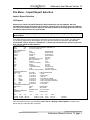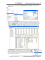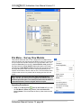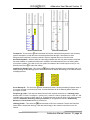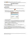
1
Version 12 Addendum Manual
Suite 314, 602 – 11th Avenue S.W.
Calgary, Alberta T2R-1J8
Phone: (403) 777-9454 Fax: (403) 777-9455
Website: www.powerlogger.com Email: [email protected]
Addendum User Manual Version 12
Overview
Version 12 Revisions
We have added numerous functionalities into the Striplog printing. The regular Striplog Title pages
have been modified to reflect the changes in the Well Record to print both the Surface Hole CoOrdinates and the Bottom Hole Co-Ordinates along with the Wireline or LWD logging runs and tools
information block.
We have given the user the ability to print a location map in both the reports and the Striplog.
We have also given the user the ability to print out the 5 survey views produced from the New Survey
View Module to the Striplog printing. We have also added the ability to print the new EUB UWI format to
the Striplog Title pages.
We have added the ability to print all 4 Surveys views to the Print to Word format and our regular Print
Well End Reports.
We have added another display option on the Directional Survey Points layer (on the right click menu)
where the user can print the survey along with the choice of displaying the TVD depth values and / or
SS depth values or neither depth value.
We have revised Well Record with the Bottom Hole Co-ordinates and Surface Hole co-ordinates and
displayed these values in both the Striplog header and well end reports.
We have added the ability to display Logarithmic curves scales in hybrid manner such as .2 to 2000
for Resistivity curves or any hybrid display of your choice.
We have added the ability to display the curve scales either horizontally or vertically on the right click
menu for a curve layer in the main body of the log. The header scales are static as they were.
We have added the ability to display the TVD and or the SSL depths for each individual survey point.
You can modify the display from the System Options Display tab or on the right click menu selection on
the directional survey points layer.
We have modified the Slide / Rotate builder to accommodate Toolface orientation and we will now
display the toolface orientation of a slide on the slide rotate layer where the S used to be displayed. If no
Toolface is entered we will revert back to the old representation of an S.
We have added the ability to Import Slides and Toolface orientation from a slide sheet acquired from a
directional driller.
We have modified the System Options - Display tab to allow the user another interface to change the
Display options for the Survey Points.
We have opened up all the annotation layers to all views (TVD, SS, OH & VS) so that the user can more
easily place their annotations for the specialty views.
We have given the user the ability to change the color of the cored interval from a solid black to any
color the user would like. This color change allows the viewer of the log to see the start and stopped of
the coring intervals if they were a continuous core.
We have added the ability to create links to other data that cannot be easily displayed on the log. This
data has to be formatted into a windows compatible display format and can be opened with a windows
application such as a Word document, XL spreadsheet or any graphics. These links can be added to all
of our layers.
We have modified the casing shoe display on the casing layer to be able to scale the shoes so that on
wide tracks they do not take over the whole track. You can find this scaling feature on the right click
menu.
We have added the Vertical Section (VS) module to Power*Curve. This module if purchased will
manipulate Power*Curve depths on a click of a mouse. The user can change the depth from Measured
Addendum Manual Version 12, page 2
Addendum User Manual Version 12
Depth (MD) to Vertical Section (VS) depth and Open Hole (OH) depth as long as the surveys have been
calculated and the last casing string has been entered.
We have added the Survey View module. This module if purchased will transform the survey data into 4
separate views which you can print from the Well End reports as well as the striplog. You will get a
detailed plan view (top down) of your well bore with respect to the survey either the DLS or NTS system
or just a gird system. You will also get a Vertical Section (parallel to the Target Azimuth) and Cross
Section View (right angles to the Target Azimuth) and a cube view which you can rotate by mouse pointer
actions. All views have the ability to go right and left and up and down manipulated by your arrow keys on
your keypad and zoom in and out using the mouse wheel on your mouse.
When you are creating a new Well / Log using an existing log template. We have modified the Add
Curves window to use as default the curve scales that were used in the exiting Log template. This
should make it easier to start a new well when you have a lot of complex curve scales.
Modified the Survey Report and Survey Points Window and reversed the E/W and N/S fields so they
correspond to the survey data received from the Directional drillers.
We have modified the Work Schedule window to expand the number of characters the Contractor field
holds from 50 to 100 characters.
We have modified the LAS Import (both right click and Import module) will now be able to accept both
LAS Version 2 and LAS Version 3 export files. Besides curve data we will also be able to import
Formations Tops, Surveys, Tests, Well and Drilling information which have been defined in the
ASCII blocks in the LAS File.
We have added a Survey Prognosis Report so the user can add the prognosed survey points (either
manually or by importing all the data through the Directional Survey Import New Method Module. This will
display the prognosed drilling program in the Survey View Module.
We have added the ability to print all 4 Surveys views to the Print to Word format and our regular
Print Well End Reports.
We have also added the use of existing curve scales and attributes from existing logs for curves that
are not recognized within the system curve definitions. This should make the creation of new logs much
easier than before.
We have added another system log for both Metric and Imperial for Gamma ray curves only.
Addendum Manual Version 12, page 3
Addendum User Manual Version 12
Table of Contents
Table of Contents ..........................................................................................................................................4
File Menu – Import Export Selection .........................................................................................................7
Import / Export Selection
7
LAS Import
7
How to Import an LAS data File
8
Overview of window
9
LAS Reader Tool Bar
10
LAS Reader File Menu
10
Importing / Mapping of LAS Curve data.
13
Import LAS curve data from a mapped file.
14
Importing / Mapping of LAS Formation Top data.
16
Import LAS Formation Tops data with a Mapped file.
19
Importing / Mapping of LAS Inclinometry (Group) data.
20
Import LAS Survey Group data with a Mapped file.
22
Importing / Mapping of LAS Inclinometry (survey) data.
24
Import LAS Inclinometry data with a Mapped file.
26
Importing / Mapping of Core data.
28
Import LAS Core data with a Mapped file.
30
Importing / Mapping of Drill Stem Test (DST) data.
32
Import LAS Drill Stem Test data with a Mapped file.
34
Import / Map - Drill Stem Test (DST) period data.
36
Import LAS Drill Stem Test period data with a Mapped file.
38
Importing / Mapping of LAS Sample Description data.
40
Import LAS Sample Description data from a mapped file.
42
Importing / Mapping of LAS Core Description data.
44
Import LAS Core Description data from a mapped file.
46
Slide Data Import
48
Importing Slide Data
48
Overview of the window.
50
Importing / Mapping of Slide data.
51
How to Import Slide Data with an Existing mapping file.
52
Slide / Rotate Export
55
Print Log
55
Print Well End Report
59
Print “Well End and AM” Reports to Word Format
63
How to Print Well End Reports to Word Format.
64
How to Print Morning Reports to Word Format.
67
File Menu – Survey View Module ............................................................................................................ 68
Operating Procedures
68
How to Open a set of Surveys for a well.
70
DLS Example
71
NTS Example
72
No Survey System
74
File Menu- Save Screen
75
File Menu- Connect to Database
76
File Menu- Disconnect to Database
76
File Menu- Exit
76
Edit Menu - Properties
77
Overview of Properties Window
77
NTS Example
81
Edit Menu – Add Survey
82
Edit Menu – Remove Survey plots
83
View Menu
83
Addendum Manual Version 12, page 4
Addendum User Manual Version 12
Plan view (isolated)
83
Toolbar Selection
84
Status Bar Selection
85
User defined view (isolated)
85
Vertical Section view (isolated)
86
Cross Section view (isolated)
87
Multi Views
88
Window Menu
89
Help Menu
90
Edit Menu – Well Selection ...................................................................................................................... 90
View Menu – Depth View Mode ............................................................................................................... 92
Depth View Mode
92
Reports Menu – Core ............................................................................................................................... 94
Adding a Core
94
Editing a Core
95
Deleting a Core
95
Reports Menu – Survey Prognosis ......................................................................................................... 96
Adding a Directional Survey Group
96
Directional Survey Point Window
97
Adding a New Record
97
Editing a Directional Survey Point
97
Deleting a Directional Survey Point
97
Display Tab
98
Log Layers............................................................................................................................................... 102
All Log layers - Link Layer
102
How to Add a Link to any Layer
102
How to Edit a Link to any Layer
103
How to Delete a Link to any Layer
104
Bit Record Layer
105
Adding Bit Record Data
105
To Change the Display
106
Moving the Bit Record Text Independently without the Right Click Options
107
Casing Layer
107
Adding Casing Data
107
To Change the Display
108
Moving the Casing Text Independently without the Right Click Options
109
Curve Fill Layer (Well Path Option on Single Curve)
110
How to Set the Well Path Curve Fill options
110
Well Path Curve Fill Layer – Bedding Angle Contacts builder
112
Single Value Data Entry
112
Multiple Value Data Entry
113
Depth Layer
115
How to Change the Depth View on a log.
115
Right Click Font Orientation Menu Options on Depth Layer.
116
Right Click Show Units Menu Options on Depth Layer.
116
Directional Survey Points Layer
116
Adding Directional Survey Data
117
To Change the Display
117
Moving the Directional Survey Text Independently without the Right Click Options
118
Formation Tops (Long Name) Layer
118
Adding a Formation
118
To Change the Display
119
Moving the Formation Name Text Independently without the Right Click Options
120
Slide / Rotate Layer
120
Drawing a Slide
121
Deleting a Slide
122
Addendum Manual Version 12, page 5
Addendum User Manual Version 12
Resizing a Slide
Right Click Options for the Slide Rotate builder.
Modifying the Display settings for the Slide / Rotate layer
Curve Layer
Adding a (Logarithmic) Curve to the New Curve Layer
Curve Layer
Digital Curve - Right Click Pop-Out Menu
Addendum Manual Version 12, page 6
122
122
122
124
124
126
126
Addendum User Manual Version 12
File Menu – Import Export Selection
Import / Export Selection
LAS Import
Allows you to import Log ASCII Standard (LAS) formatted files into the database. We have
separated these import procedures into 2 sections. The first section is How to Import an LAS data
File. The second section is How to Import an LAS data file with a saved mapping file. We now have
the ability to Import Version 2 or 3 file formats.
The user can also import a single curve into an existing curve by referring to the Right Click
import method.
If the ASCII files you receive looks like the file shown on the next page it is an LAS file. The ASCII data
can be directly imported into the database as long as the Well exists in the database. You can now
proceed with “How to import an LAS data File”. If it does not look similar you will have to proceed
with “How to Import an ASCII data file”.
~Version Information
VERS.
3.00
:CWLS LOG ASCII STANDARD - VERSION 3.00
WRAP.
NO
:One line per depth step
~WELL INFORMATION
#MNEM.UNIT
DATA
DESCRIPTION
STRT.M
178.46040
:START DEPTH
STOP.M
2206.44720
:STOP DEPTH
STEP.M
0.15240
:STEP LENGTH
NULL.
-999.22000
:Null value
COMP.
ABC Exploration Company
:Company
WELL.
ABC et al Anywhere
:Well
FLD.
Anywhere
:Field
LOC.
111/09-12-015-5W4M
:Location
PROV.
Alberta
:Province
DATE.
14-MAR-96
:Run Date
UWI.
111012601505W400
:Unique Well ID
LIC.
12356
:License Number
SRVC.
Anywhere Logging Company :SERVICE COMPANY
~CURVE INFORMATION
#MNEM.UNIT
API CODE
CURVE DESCRIPTION
DEPT
.M
00 001 00 00
: 1 Depth
GR
.GAPI
01 310 01 00
: 2 Gamma Ray
DT
.US/M
01 520 80 00
: 3 DELTA-T
SP
.MV
01 010 01 00
: 4 Spontaneous Potential
LLD
.OHMM
01 220 10 00
: 5 Latero-Log Deep (Resistivity)
LLS
.OHMM
01 220 09 00
: 6 Latero-Log Shallow (Resistivity)
HD
.MM
01 280 01 00
: 7 Hole Diameter
TDEP
.M
01 636 00 00
: 8 Tide Depth
~PARAMETER INFORMATION
#MNEM.UNIT
VALUE
DESCRIPTION
RUN.
ONE
:Run Number
PDAT.
GROUND LEVEL :Permanent Datum
~OTHER INFORMATION
#MNEM.UNIT
VALUE
DESCRIPTION
~A
DEPT
GR
DT
SP
LLD
LLS
HD
TDEP
178.4604 52.4498 182.4146
96.9375 3.8158 0.1481 210.3713
178.6128 47.9652 182.4146
96.6250 3.2990 0.1484 210.3713
178.46042
178.61282
If the well does not exist in your database please refer to “Starting a New Log/Well” to create a new
well so that you can import the curve data.
Addendum Manual Version 12, page 7
Addendum User Manual Version 12
How to Import an LAS data File
If the file format is LAS V3.0 then we can import, beside curve data, Formation, Test, Inclinometry and
Core Data directly into the database. If it is LAS V2.0 then we will only be able to import curve data. This
method allows the user to import multiple curves at a time as opposed to the right click on a curve layer
which allows the user to import a single curve.
1.
Click on the File pull down menu selection and click on Import / Export and then click on Import /
Export LAS and then select LAS Import from the pop out-menu or simply click on the
button, on the Toolbar, to activate the LAS Reader window.
LAS
2. This will then activate the Open window which allows the user to select the LAS file you wish to
import the data from. Find the file and directory and highlight the file by click on it once and then
click on the
button. If your log is open at the time you will see something similar to the
window shown below. We will default to the importing of Curve data.
Addendum Manual Version 12, page 8
Addendum User Manual Version 12
Overview of window
The left hand side of the LAS Reader window (shown on the right)
allows the user to see the tree view of the data file format including the
different data, parameter and definition blocks. The tree enables the user
to select different sets of data or definitions. We have the choice to import
these data types into the predefined data sets such as curves,
Inclinometry, Tests, Tops and Core Data within the Power*Suite
application. We default the window to select the log data or curve data if it
is available
The upper right hand side of the LAS Reader window (shown below)
allows the user to see the data associated with the different data and
parameters and definition blocks.
The middle bottom portion of the LAS Reader window (Shown below left) displays the parameters or
data sets that have been selected from the tree view on the left. These can then be dragged to the import
side of the LAS reader.
The bottom right hand side of the LAS Reader window (shown above right) allows the user to see the
different data sets we import as determined by the choose data type selection drop box. Curve names
description and units for the curves as well as the curve layers associated with the log that is open and
active at the time the LAS Reader window was invoked.
The Choose Data Type drop box allows the user to
import data into different tables within the Power*Suite
application. We default this window to curves but we
can import other data such as survey Formation,
Surveys, Core Descriptions, Sample Descriptions, Core
Run, DST Run and DST Period data sets. The user
must first pick the data set from the tree and then select
the data type so they can then map the data from the
file to the database table.
The Curve Depth Column drop box will appear if the curves data type is
selected the Choose Data Type drop box which will be the default when
the LAS Reader application is initiated. Most LAS file formats for curve data will have depth as the first
column but this is not mandatory. We will default to the first column or a column identified with the
standard DEPT but if it is not the depth column the user can then identify the column with the Curve
Depth Column drop box above the columns and their descriptions.
Addendum Manual Version 12, page 9
Addendum User Manual Version 12
The Top Base Step portion of the window appears if the curves data type is selected from
the Choose Data Type drop box which will be the default when the LAS Reader application is
initiated. This allows the user to import all or a portion of the of the curve data from the file
into your open log. The user can enter new top and base depths fields to import only a
portion of the LAS data file. This interval has do correspond to the lesser or equal to the
depths corresponding in the data.
The Choose Survey Group drop box will appear if you select Surveys from
the Choose data type drop box. This allows the user to pick a different survey
group to import to. This survey group must be defined before the LAS Reader application has been
initiated.
The Choose Test Run # and Choose Test # drop boxes will appear if you
select DST from the Choose data type drop box. This allows the user to pick
the correct run # and test number for that run to import the data to. This The
DST can be created before in the DST report menu or can be imported through the LAS reader by
choosing the DST Job selection.
The
button commences the import of data from the file that was mapped form bottom middle
portion of the window to the data sets on the bottom right hand portion of the window.
LAS Reader Tool Bar
LAS Reader File Menu
File Menu - Open LAS Option
Select Open LAS file, under the File menu selection if you would like to
open another LAS file or you did not select one when the LAS reader
application was activated. Or, you can click on the
button on the
Toolbar. This will activate the Open LAS file window. Navigate the folder
structure and highlight the file you want and then click on the
button
Addendum Manual Version 12, page 10
Addendum User Manual Version 12
File Menu - Choose Well / Log Option
1.
Select Choose Well / Log, under the File menu
selection if you would like to open a different Well / Log
you did not have a log open when the LAS Reader
or
Application was activated. Or, you can click on the
button on the Toolbar. This will activate the Choose a
window
log
2.
Click on the + beside available wells to open the tree
of the wells in your database.
3. Click on the dot beside the UWI of the well to show
list of logs available.
4. Click on the log format (highlight) you want that has the curve layers available to import into.
5.
Click on the
export data out of.
list
the
button. This will open another log / well for you to import data into or
File Menu – Open Map file Option
This allows the user to utilize the mapping file saved from the save amp file option to remap the curves /
data to the layers or the database table fields.
1.
Select Open Map file, under the File menu selection if you would like to
open a saved mapping file for a particular data set. Or, you can click on
the
button on the Toolbar. This will activate the Open Map file
window that has been saved from previous imports and they will be
initiated by the Choose data type to import drop box selection.
N.B. The file extensions are *.cvm for curve data, *.ftm for formation data, *.sgc for survey group data,
*.inc for survey data, *.cdm for core data, *.tgc for DST job data, and *.tmf for DST interval data.
File Menu – Save Map file Option
This allows the user to save a mapping file after you have clicked and dragged the particular data from
the LAS file to the appropriate curve layer or data type in our database table. This file is saved with a
certain extension that we add to the mapping file name.
Addendum Manual Version 12, page 11
Addendum User Manual Version 12
1. Select Save Map file, under the File menu selection if you would
like to save the mapping that you have just finished for a particular
data set. Or, you can click on the
button on the Toolbar. This
will activate the Open Map file window that has been saved from
previous imports and they will be initiated by the Choose data type
import drop box selection.
to
File Menu – Export Well Option
This allows the user to export all of the well’s data in an LAS V3.0 data format. This will export every table
from the database very similar to the Data transfer module but not in a binary format but in a format that is
readable by an LAS reader.
1. Select Export Well, under the File menu selection or you can click on the
Toolbar. This will activate the Save LAS file window.
button on the
2. We will default the file name to the well name. If the file name is OK then click on the
button. This will activate the Curve Export Options window.
3. The user can modify the interval and the step if they so desire. The step may effect the curve data at
the end of the file as they step may alter the final readings on an LAS file curve depths. We default to
the best step available but the user can change the step and then click on the
verify the step is ok.
button to
We take the first curve depth from the shallowest curve and the last curve depth from the deepest of the
curves and modify the step so that all the data will have a common step.
4. Click on the
button when you are done. This will activate a please wait window and when the
window disappears the file has been created in the folder you have chosen.
File Menu – Exit Option
This allow the user to exit the LAS Reader application
Addendum Manual Version 12, page 12
Addendum User Manual Version 12
Importing / Mapping of LAS Curve data.
1. With your well open in Power*Log / Curve or Core Click on the File pull down menu selection and
click on Import / Export and then click on Import / Export LAS and then select LAS Import from
the pop out-menu or simply click on the
Reader window.
LAS button, on the Toolbar, to activate the LAS
2. This will then activate the Open window which allows the user to select the LAS file you wish to
import the data from. Find the file and directory and highlight the file by click on it once and then
click on the
button. If your log is open at the time you will see something similar to the
window shown below. We will default to the importing of Curve data. The user has the option to
highlight different curve / log data sets from the tree list on the left of the LAS Reader window.
Addendum Manual Version 12, page 13
Addendum User Manual Version 12
3. On the lower left side of the window Click and drag the curve you wish to import to the curve layer
on the lower right side and release it when the layer becomes highlighted.
N.B. The user can Right click on the Curve Layer ID to remove the mapping or switch the action from
append to replace. The Symbol color will either be purple for replace or blue for append.
4. Repeat the Clicking and Dragging of curves to curve layers until all have been mapped. The user
can also bring over new curves to the well without having a layer to show the curves on. You would
then have to associate that curve to a new layer at a later date. This would be done through the log
configuration builder on adding a new curve layer.
5. The user can save this mapping procedure at this time by clicking on
the
button or click on the File menu and Select the Save map
file option and giving this procedure a file name and folder to be used
again at a later date when you would have to import similar LAS Curve
data again.
6. Click on the
button. You will then be prompted with a system
message after the import has finished.
7. Acknowledge the Finished Import message. Click on the
button and then click on the
button to exit or click on the File menu and select the Exit option to close the LAS Reader
Window.
Import LAS curve data from a mapped file.
1. With your well open in Power*Log / Curve or Core Click on the File pull down menu selection and
click on Import / Export and then click on Import / Export LAS and then select LAS Import from
Addendum Manual Version 12, page 14
Addendum User Manual Version 12
the pop out-menu or simply click on the
Reader window.
LAS button, on the Toolbar, to activate the LAS
2. This will then activate the Open window which allows the user to select the LAS file you wish to
import the data from. Find the file and directory and highlight the file by click on it once and then
click on the
button. If your log is open at the time you will see something similar to the
window shown below. We will default to the importing of Curve data. The user has the option to
highlight different curve / log data sets from the tree list on the left of the LAS Reader window.
3. Select Open Map file, under the File menu selection if you would like to open
a saved mapping file for a particular data set. Or, you can click on the
button on the Toolbar. This will activate the Open Map file window that has
been saved from previous imports and they will be initiated by the Choose data
type to import drop box selection.
Addendum Manual Version 12, page 15
Addendum User Manual Version 12
N.B. The file extensions are *.cvm for curve data, *.ftm for formation data, *.sgc for survey group data,
*.inc for survey data, *.cdm for core data, *.tgc for DST job data, *.tmf for DST interval data *.sdm for
sample descriptions and *.cdm for Core Description data.
4. Select the mapping file with the *.cvm saved from previous imports of similar data to similar logs and
click on the
button.
N.B. The user can Right click on the Curve Layer ID to remove the mapping or switch the action from
append to replace.
5. The user can map more curves on the left side of the window by clicking and dragging the curve
you wish to import to the curve layer on the right side and release it when the layer becomes
highlighted.
6. Click on the
finished.
button. You will then be prompted with a system message after the import has
7. Acknowledge the Finished Import message. Click on the
button and then click on the
button to exit or click on the File menu and select the Exit option to close the LAS Reader
Window.
Importing / Mapping of LAS Formation Top data.
1. With your well open in Power*Log / Curve or Core Click on the File pull down menu selection and
click on Import / Export and then click on Import / Export LAS and then select LAS Import from
the pop out-menu or simply click on the
Reader window.
LAS button, on the Toolbar, to activate the LAS
Addendum Manual Version 12, page 16
Addendum User Manual Version 12
2. This will then activate the Open window which allows the user to select the LAS file you wish to
import the data from. Find the file and directory and highlight the file by click on it once and then
click on the
button. If your log is open at the time you will see something similar to the
window shown below. We will default to the importing of Curve data. The user must highlight the
Formation Top data set from the tree list on the left of the LAS Reader window.
3. Select Formations from the Choose Data type drop box.
4. On the lower left side of the window click and drag the Formation top data you wish to import to the
formation data type field on the lower right side and release it when the data field becomes
Addendum Manual Version 12, page 17
Addendum User Manual Version 12
highlighted. Mandatory fields are highlighted in a yellow symbol
record to exist in the database.
and must be mapped for the
N.B. The user can remove the mapping by right clicking on the data field and selecting remove mapping.
5. Repeat the Clicking and Dragging of LAS field data to the data fields of the database table for
formation tops until all have been mapped.
6. The user can save this mapping procedure at this time by clicking on
the
button or click on the File menu and Select the Save map
file option and giving this procedure a file name and folder to be used
again at a later date when you would have to import similar LAS
Formation top data again.
7. Click on the
button. You will then be prompted with a system
message after the import has finished.
8. Acknowledge the Finished Import message. Click on the
button and then click on the
button to exit or click on the File menu and select the Exit option to close the LAS Reader
Window
Addendum Manual Version 12, page 18
Addendum User Manual Version 12
Import LAS Formation Tops data with a Mapped file.
1. With your well open in Power*Log / Curve or Core Click on the File pull down menu selection and
click on Import / Export and then click on Import / Export LAS and then select LAS Import from
the pop out-menu or simply click on the
Reader window.
LAS button, on the Toolbar, to activate the LAS
2. This will then activate the Open window which allows the user to select the LAS file you wish to
import the data from. Find the file and directory and highlight the file by click on it once and then
click on the
button. If your log is open at the time you will see something similar to the
window shown below. We will default to the importing of Curve data. The user must highlight the
Formation Top data set from the tree list on the left of the LAS Reader window.
3. Select Formations from the Choose Data type drop box.
4. Select Open Map file, under the File menu selection if you would like to
open a saved mapping file for a particular data set. Or, you can click on
Addendum Manual Version 12, page 19
Addendum User Manual Version 12
the
button on the Toolbar. This will activate the Open Map file window that has been saved
from previous imports and they will be initiated by the Choose data type to import drop box selection.
N.B. The file extensions are *.cvm for curve data, *.ftm for formation data, *.sgc for survey group data,
*.inc for survey data, *.cdm for core data, *.tgc for DST job data, and *.tmf for DST interval data.
5. Select the mapping file with the *.ftm saved from previous imports of similar data to the database and
click on the
button.
N.B. The user can Right click on the Data field to remove the mapping.
6. The user can map more data on the left side of the window by clicking and dragging the data you
wish to import to the data field on the right side and release it when the layer becomes highlighted.
7. Click on the
finished.
button. You will then be prompted with a system message after the import has
8. Acknowledge the Finished Import message. Click on the
button and then click on the
button to exit or click on the File menu and select the Exit option to close the LAS Reader
Window.
Importing / Mapping of LAS Inclinometry (Group) data.
1. With your well open in Power*Log / Curve or Core Click on the File pull down menu selection and
click on Import / Export and then click on Import / Export LAS and then select LAS Import from
the pop out-menu or simply click on the
Reader window.
LAS button, on the Toolbar, to activate the LAS
Addendum Manual Version 12, page 20
Addendum User Manual Version 12
2. This will then activate the Open window which allows the user to select the LAS file you wish to
import the data from. Find the file and directory and highlight the file by click on it once and then
click on the
button. If your log is open at the time you will see something similar to the
window shown below. We will default to the importing of Curve data. The user must highlight the
Survey group data set from the tree list on the left of the LAS Reader window.
3. Select Survey Group from the Choose Data type drop box.
4. On the lower left side of the window click and drag the Survey group data you wish to import to the
survey group data type field on the lower right side and release it when the data field becomes
Addendum Manual Version 12, page 21
Addendum User Manual Version 12
highlighted. Mandatory fields are highlighted in a yellow symbol
record to exist in the database.
and must be mapped for the
N.B. The user can remove the mapping by right clicking on the data field and selecting remove mapping.
5. Repeat the Clicking and Dragging of LAS field data to the data fields of the database table for the
survey data until all have been mapped.
6. The user can save this mapping procedure at this time by clicking on
the
button or click on the File menu and Select the Save map
file option and giving this procedure a file name and folder to be used
again at a later date when you would have to import similar LAS
Inclinometry data (survey data) again.
7. Click on the
button. You will then be prompted with a system
message after the import has finished.
8. Acknowledge the Finished Import message. Click on the
button and then click on the
button to exit or click on the File menu and select the Exit option to close the LAS Reader
Window.
Import LAS Survey Group data with a Mapped file.
1. With your well open in Power*Log / Curve or Core Click on the File pull down menu selection and
click on Import / Export and then click on Import / Export LAS and then select LAS Import from
the pop out-menu or simply click on the
Reader window.
LAS button, on the Toolbar, to activate the LAS
Addendum Manual Version 12, page 22
Addendum User Manual Version 12
2. This will then activate the Open window which allows the user to select the LAS file you wish to
import the data from. Find the file and directory and highlight the file by click on it once and then
click on the
button. If your log is open at the time you will see something similar to the
window shown below. We will default to the importing of Curve data. The user must highlight the
Inclinometry data set from the tree list on the left of the LAS Reader window.
3. Select Surveys Group from the Choose Data type drop box.
4. Select Open Map file, under the File menu selection if you would like to open a saved mapping file
for a particular data set. Or, you can click on the
button on the Toolbar. This will activate the
Open Map file window that has been saved from previous imports and they will be initiated by the
Choose data type to import drop box selection.
Addendum Manual Version 12, page 23
Addendum User Manual Version 12
5. Select the mapping file with the *.sgc saved from previous imports of similar data to the database
and click on the
button.
N.B. The user can Right click on the Data field to remove the mapping.
6. The user can map more data on the left side of the window by clicking and dragging the data you
wish to import to the data field on the right side and release it when the layer becomes highlighted.
7. Click on the
finished.
button. You will then be prompted with a system message after the import has
8. Acknowledge the Finished Import message. Click on the
button and then click on the
button to exit or click on the File menu and select the Exit option to close the LAS Reader
Window.
Importing / Mapping of LAS Inclinometry (survey) data.
1. With your well open in Power*Log / Curve or Core Click on the File pull down menu selection and
click on Import / Export and then click on Import / Export LAS and then select LAS Import from
the pop out-menu or simply click on the
Reader window.
LAS button, on the Toolbar, to activate the LAS
Addendum Manual Version 12, page 24
Addendum User Manual Version 12
2. This will then activate the Open window which allows the user to select the LAS file you wish to
import the data from. Find the file and directory and highlight the file by click on it once and then
click on the
button. If your log is open at the time you will see something similar to the
window shown below. We will default to the importing of Curve data. The user must highlight the
Inclinometry data set from the tree list on the left of the LAS Reader window.
3. Select Surveys from the Choose Data type drop box.
4. Select the survey group you wish to import the data into from the Choose Survey group drop box
5. On the lower left side of the window click and drag the Survey data you wish to import to the
survey data type field on the lower right side and release it when the data field becomes highlighted.
Mandatory fields are highlighted in a yellow symbol
the database.
and must be mapped for the record to exist in
N.B. The user can remove the mapping by right clicking on the data field and selecting remove mapping.
6. Repeat the Clicking and Dragging of LAS field data to the data fields of the database table for the
survey data until all have been mapped.
Addendum Manual Version 12, page 25
Addendum User Manual Version 12
7. The user can save this mapping procedure at this time by clicking on
the
button or click on the File menu and Select the Save map
file option and giving this procedure a file name and folder to be used
again at a later date when you would have to import similar LAS
Inclinometry data (survey data) again.
8. Click on the
button. You will then be prompted with a system
message after the import has finished.
9. Acknowledge the Finished Import message. Click on the
button and then click on the
button to exit or click on the File menu and select the Exit option to close the LAS Reader
Window.
Import LAS Inclinometry data with a Mapped file.
1. With your well open in Power*Log / Curve or Core Click on the File pull down menu selection and
click on Import / Export and then click on Import / Export LAS and then select LAS Import from
the pop out-menu or simply click on the
Reader window.
LAS button, on the Toolbar, to activate the LAS
Addendum Manual Version 12, page 26
Addendum User Manual Version 12
2. This will then activate the Open window which allows the user to select the LAS file you wish to
import the data from. Find the file and directory and highlight the file by click on it once and then
click on the
button. If your log is open at the time you will see something similar to the
window shown below. We will default to the importing of Curve data. The user must highlight the
Inclinometry data set from the tree list on the left of the LAS Reader window.
3. Select Surveys from the Choose Data type drop box.
4. Select the survey group you wish to import the data into from the Choose Survey group drop box
5. Select Open Map file, under the File menu selection if you would like to open a saved mapping file
for a particular data set. Or, you can click on the
button on the Toolbar. This will activate the
Open Map file window that has been saved from previous imports and they will be initiated by the
Choose data type to import drop box selection.
Addendum Manual Version 12, page 27
Addendum User Manual Version 12
6. Select the mapping file with the *.inc saved from previous imports of similar data to the database and
click on the
button.
N.B. The user can Right click on the Data field to remove the mapping.
7. The user can map more data on the left side of the window by clicking and dragging the data you
wish to import to the data field on the right side and release it when the layer becomes highlighted.
8. Click on the
finished.
button. You will then be prompted with a system message after the import has
9. Acknowledge the Finished Import message. Click on the
button and then click on the
button to exit or click on the File menu and select the Exit option to close the LAS Reader
Window.
Importing / Mapping of Core data.
1. With your well open in Power*Log / Curve or Core Click on the File pull down menu selection and
click on Import / Export and then click on Import / Export LAS and then select LAS Import from
the pop out-menu or simply click on the
Reader window.
LAS button, on the Toolbar, to activate the LAS
Addendum Manual Version 12, page 28
Addendum User Manual Version 12
2. This will then activate the Open window which allows the user to select the LAS file you wish to
import the data from. Find the file and directory and highlight the file by click on it once and then
click on the
button. If your log is open at the time you will see something similar to the
window shown below. We will default to the importing of Curve data. The user must highlight the
Core data set from the tree list on the left of the LAS Reader window.
3. Select Cores from the Choose Data type drop box.
4. On the lower left side of the window click and drag the Core data you wish to import to the core
data type field on the lower right side and release it when the data field becomes highlighted.
Mandatory fields are highlighted in a yellow symbol
the database.
and must be mapped for the record to exist in
N.B. The user can remove the mapping by right clicking on the data field and selecting remove mapping.
5. Repeat the Clicking and Dragging of LAS field data to the data fields of the database table for the
core data until all have been mapped.
Addendum Manual Version 12, page 29
Addendum User Manual Version 12
6. The user can save this mapping procedure at this time by clicking on
the
button or click on the File menu and Select the Save map
file option and giving this procedure a file name and folder to be used
again at a later date when you would have to import similar LAS Core
data again.
7. Click on the
button. You will then be prompted with a system
message after the import has finished.
8. Acknowledge the Finished Import message. Click on the
button and then click on the
button to exit or click on the File menu and select the Exit option to close the LAS Reader
Window.
Import LAS Core data with a Mapped file.
1. With your well open in Power*Log / Curve or Core Click on the File pull down menu selection and
click on Import / Export and then click on Import / Export LAS and then select LAS Import from
the pop out-menu or simply click on the
Reader window.
LAS button, on the Toolbar, to activate the LAS
Addendum Manual Version 12, page 30
Addendum User Manual Version 12
2. This will then activate the Open window which allows the user to select the LAS file you wish to
import the data from. Find the file and directory and highlight the file by click on it once and then
click on the
button. If your log is open at the time you will see something similar to the
window shown below. We will default to the importing of Curve data. The user must highlight the
core data set from the tree list on the left of the LAS Reader window.
3. Select Cores from the Choose Data type drop box.
4. Select Open Map file, under the File menu selection if you would like to open a saved mapping file
for a particular data set. Or, you can click on the
button on the Toolbar. This will activate the
Open Map file window that has been saved from previous imports and they will be initiated by the
Choose data type to import drop box selection.
Addendum Manual Version 12, page 31
Addendum User Manual Version 12
5. Select the mapping file with the *.cdm saved from previous imports of similar data to the database
and click on the
button.
N.B. The user can Right click on the Data field to remove the mapping.
6. The user can map more data on the left side of the window by clicking and dragging the data you
wish to import to the data field on the right side and release it when the layer becomes highlighted.
7. Click on the
finished.
button. You will then be prompted with a system message after the import has
8. Acknowledge the Finished Import message. Click on the
button and then click on the
button to exit or click on the File menu and select the Exit option to close the LAS Reader
Window.
Importing / Mapping of Drill Stem Test (DST) data.
1. With your well open in Power*Log / Curve or Core Click on the File pull down menu selection and
click on Import / Export and then click on Import / Export LAS and then select LAS Import from
the pop out-menu or simply click on the
Reader window.
LAS button, on the Toolbar, to activate the LAS
Addendum Manual Version 12, page 32
Addendum User Manual Version 12
2. This will then activate the Open window which allows the user to select the LAS file you wish to
import the data from. Find the file and directory and highlight the file by click on it once and then
click on the
button. If your log is open at the time you will see something similar to the
window shown below. We will default to the importing of Curve data. The user must highlight the
DST data set from the tree list on the left of the LAS Reader window.
3. Select DST Job from the Choose Data type drop box.
4. On the lower left side of the window click and drag the DST data you wish to import to the core data
type field on the lower right side and release it when the data field becomes highlighted. Mandatory
fields are highlighted in a yellow symbol
database.
and must be mapped for the record to exist in the
N.B. The user can remove the mapping by right clicking on the data field and selecting remove mapping.
5. Repeat the Clicking and Dragging of LAS field data to the data fields of the database table for the
DST data until all have been mapped.
Addendum Manual Version 12, page 33
Addendum User Manual Version 12
6. The user can save this mapping procedure at this time by clicking on
the
button or click on the File menu and Select the Save map
file option and giving this procedure a file name and folder to be used
again at a later date when you would have to import similar LAS DST
data again.
7. Click on the
button. You will then be prompted with a system
message after the import has finished.
8. Acknowledge the Finished Import message. Click on the
button and then click on the
button to exit or click on the File menu and select the Exit option to close the LAS Reader
Window.
Import LAS Drill Stem Test data with a Mapped file.
1. With your well open in Power*Log / Curve or Core Click on the File pull down menu selection and
click on Import / Export and then click on Import / Export LAS and then select LAS Import from
the pop out-menu or simply click on the
Reader window.
LAS button, on the Toolbar, to activate the LAS
Addendum Manual Version 12, page 34
Addendum User Manual Version 12
2. This will then activate the Open window which allows the user to select the LAS file you wish to
import the data from. Find the file and directory and highlight the file by click on it once and then
click on the
button. If your log is open at the time you will see something similar to the
window shown below. We will default to the importing of Curve data. The user must highlight the
core data set from the tree list on the left of the LAS Reader window.
3. Select DST Job from the Choose Data type drop box.
4. Select Open Map file, under the File menu selection if you would like to open a saved mapping file
for a particular data set. Or, you can click on the
button on the Toolbar. This will activate the
Open Map file window that has been saved from previous imports and they will be initiated by the
Choose data type to import drop box selection.
Addendum Manual Version 12, page 35
Addendum User Manual Version 12
5. Select the mapping file with the *.tgc saved from previous imports of similar data to the database and
click on the
button.
N.B. The user can Right click on the Data field to remove the mapping.
6. The user can map more data on the left side of the window by clicking and dragging the data you
wish to import to the data field on the right side and release it when the layer becomes highlighted.
7. Click on the
finished.
button. You will then be prompted with a system message after the import has
8. Acknowledge the Finished Import message. Click on the
button and then click on the
button to exit or click on the File menu and select the Exit option to close the LAS Reader
Window.
Import / Map - Drill Stem Test (DST) period data.
1. With your well open in Power*Log / Curve or Core Click on the File pull down menu selection and
click on Import / Export and then click on Import / Export LAS and then select LAS Import from
the pop out-menu or simply click on the
Reader window.
LAS button, on the Toolbar, to activate the LAS
Addendum Manual Version 12, page 36
Addendum User Manual Version 12
2. This will then activate the Open window which allows the user to select the LAS file you wish to
import the data from. Find the file and directory and highlight the file by click on it once and then
click on the
button. If your log is open at the time you will see something similar to the
window shown below. We will default to the importing of Curve data. The user must highlight the
DST period data set from the tree list on the left of the LAS Reader window.
3. Select DST from the Choose Data type drop box.
4. If the Data has the Test Run # and the Test # we can map those over. If not then we have to choose
the Test Run # and the Test # from their respective drop boxes.
5. On the lower left side of the window click and drag the DST data you wish to import to the core data
type field on the lower right side and release it when the data field becomes highlighted. Mandatory
fields are highlighted in a yellow symbol
database.
and must be mapped for the record to exist in the
N.B. The user can remove the mapping by right clicking on the data field and selecting remove mapping.
6. Repeat the Clicking and Dragging of LAS field data to the data fields of the database table for the
DST data until all have been mapped.
Addendum Manual Version 12, page 37
Addendum User Manual Version 12
7. The user can save this mapping procedure at this time by clicking on
the
button or click on the File menu and Select the Save map
file option and giving this procedure a file name and folder to be used
again at a later date when you would have to import similar LAS DST
data again.
8. Click on the
button. You will then be prompted with a system
message after the import has finished.
9. Acknowledge the Finished Import message. Click on the
button and then click on the
button to exit or click on the File menu and select the Exit option to close the LAS Reader
Window.
Import LAS Drill Stem Test period data with a Mapped file.
1. With your well open in Power*Log / Curve or Core Click on the File pull down menu selection and
click on Import / Export and then click on Import / Export LAS and then select LAS Import from
the pop out-menu or simply click on the
Reader window.
LAS button, on the Toolbar, to activate the LAS
Addendum Manual Version 12, page 38
Addendum User Manual Version 12
2. This will then activate the Open window which allows the user to select the LAS file you wish to
import the data from. Find the file and directory and highlight the file by click on it once and then
click on the
button. If your log is open at the time you will see something similar to the
window shown below. We will default to the importing of Curve data. The user must highlight the
DST period data set from the tree list on the left of the LAS Reader window.
3. Select DST from the Choose Data type drop box.
4. If the Data has the Test Run # and the Test # we can map those over. If not then we have to choose
the Test Run # and the Test # from their respective drop boxes.
5. Select Open Map file, under the File menu selection if you would like to open a saved mapping file
for a particular data set. Or, you can click on the
button on the Toolbar. This will activate the
Open Map file window that has been saved from previous imports and they will be initiated by the
Choose data type to import drop box selection.
Addendum Manual Version 12, page 39
Addendum User Manual Version 12
6. Select the mapping file with the *.tmf saved from previous imports of similar data to the database and
click on the
button.
N.B. The user can Right click on the Data field to remove the mapping.
7. The user can map more data on the left side of the window by clicking and dragging the data you
wish to import to the data field on the right side and release it when the layer becomes highlighted.
8. Click on the
finished.
button. You will then be prompted with a system message after the import has
9. Acknowledge the Finished Import message. Click on the
button and then click on the
button to exit or click on the File menu and select the Exit option to close the LAS Reader
Window.
Importing / Mapping of LAS Sample Description data.
1. With your well open in Power*Log / Curve or Core Click on the File pull down menu selection and
click on Import / Export and then click on Import / Export LAS and then select LAS Import from
the pop out-menu or simply click on the
Reader window.
LAS button, on the Toolbar, to activate the LAS
Addendum Manual Version 12, page 40
Addendum User Manual Version 12
2. This will then activate the Open window which allows the user to select the LAS file you wish to
import the data from. Find the file and directory and highlight the file by click on it once and then
click on the
button. If your log is open at the time you will see something similar to the
window shown below. We will default to the importing of Curve data. Highlight the Sample
Description data set from the tree list on the left of the LAS Reader window.
3. Select Sample Description from the Choose Data type drop box.
4. On the lower left side of the window click and drag the Sample Description Data in the LAS file you
wish to import to the sample description table data field on the lower right side and release it when
the data field becomes highlighted.
N.B. The user can Right click on the Data Field to remove the mapping.
Addendum Manual Version 12, page 41
Addendum User Manual Version 12
5. Repeat the Clicking and Dragging of the data to the database table until all the data has been
mapped. The user can then use the Sample description report to manipulate the data or the Sample /
Core description transfer option to place the description onto the log.
6. The user can save this mapping procedure at this time by clicking on
the
button or click on the File menu and Select the Save map
file option and giving this procedure a file name and folder to be used
again at a later date when you would have to import similar LAS Curve
data again.
7. Click on the
button. You will then be prompted with a system
message after the import has finished.
8. Acknowledge the Finished Import message. Click on the
button and then click on the
button to exit or click on the File menu and select the Exit option to close the LAS Reader
Window.
Import LAS Sample Description data from a mapped file.
1. With your well open in Power*Log / Curve or Core Click on the File pull down menu selection and
click on Import / Export and then click on Import / Export LAS and then select LAS Import from
the pop out-menu or simply click on the
Reader window.
LAS button, on the Toolbar, to activate the LAS
Addendum Manual Version 12, page 42
Addendum User Manual Version 12
2. This will then activate the Open window which allows the user to select the LAS file you wish to
import the data from. Find the file and directory and highlight the file by click on it once and then
click on the
button. If your log is open at the time you will see something similar to the
window shown below. We will default to the importing of Curve data. Highlight the Sample
Description data set from the tree list on the left of the LAS Reader window.
3. Select Sample Description from the Choose Data type drop box.
4. Select Open Map file, under the File menu selection if you would
like to open a saved mapping file for a particular data set. Or, you
can click on the
button on the Toolbar. This will activate the
Open Map file window that has been saved from previous imports
Addendum Manual Version 12, page 43
Addendum User Manual Version 12
and they will be initiated by the Choose data type to import drop box selection.
N.B. The file extensions are *.cvm for curve data, *.ftm for formation data, *.sgc for survey group data,
*.inc for survey data, *.cdm for core data, *.tgc for DST job data, *.tmf for DST interval data *.sdm for
sample descriptions and *.cdm for Core Description data.
5. Select the mapping file with the *.sdm saved from previous imports of similar data and click on the
button.
N.B. The user can Right click on the Data Field to remove the mapping
6. The user can map more data on the left side of the window by clicking and dragging the data type
you wish to import to the data field on the right side and release it when the field becomes
highlighted.
7. Click on the
finished.
button. You will then be prompted with a system message after the import has
8. Acknowledge the Finished Import message. Click on the
button and then click on the
button to exit or click on the File menu and select the Exit option to close the LAS Reader
Window.
Importing / Mapping of LAS Core Description data.
1. With your well open in Power*Log / Curve or Core Click on the File pull down menu selection and
click on Import / Export and then click on Import / Export LAS and then select LAS Import from
the pop out-menu or simply click on the
Reader window.
LAS button, on the Toolbar, to activate the LAS
Addendum Manual Version 12, page 44
Addendum User Manual Version 12
2. This will then activate the Open window which allows the user to select the LAS file you wish to
import the data from. Find the file and directory and highlight the file by click on it once and then
click on the
button. If your log is open at the time you will see something similar to the
window shown below. We will default to the importing of Curve data. Highlight the Core Description
data set from the tree list on the left of the LAS Reader window.
3. Select Core Description from the Choose Data type drop box.
4. On the lower left side of the window click and drag the Core Description Data in the LAS file you
wish to import to the core description table data field on the lower right side and release it when the
data field becomes highlighted.
N.B. The user can Right click on the Data Field to remove the mapping.
Addendum Manual Version 12, page 45
Addendum User Manual Version 12
5. Repeat the Clicking and Dragging of the data to the database table until all the data has been
mapped. The user can then use the Sample description report to manipulate the data or the Sample /
Core description transfer option to place the description onto the log.
6. The user can save this mapping procedure at this time by clicking on
the
button or click on the File menu and Select the Save map
file option and giving this procedure a file name and folder to be used
again at a later date when you would have to import similar LAS Curve
data again.
7. Click on the
button. You will then be prompted with a system
message after the import has finished.
8. Acknowledge the Finished Import message. Click on the
button and then click on the
button to exit or click on the File menu and select the Exit option to close the LAS Reader
Window.
Import LAS Core Description data from a mapped file.
1. With your well open in Power*Log / Curve or Core Click on the File pull down menu selection and
click on Import / Export and then click on Import / Export LAS and then select LAS Import from
the pop out-menu or simply click on the
Reader window.
LAS button, on the Toolbar, to activate the LAS
Addendum Manual Version 12, page 46
Addendum User Manual Version 12
2. This will then activate the Open window which allows the user to select the LAS file you wish to
import the data from. Find the file and directory and highlight the file by click on it once and then
click on the
button. If your log is open at the time you will see something similar to the
window shown below. We will default to the importing of Curve data. Highlight the Core Description
data set from the tree list on the left of the LAS Reader window.
3. Select Core Description from the Choose Data type drop box.
4. Select Open Map file, under the File menu selection if you would
like to open a saved mapping file for a particular data set. Or, you
can click on the
button on the Toolbar. This will activate the
Open Map file window that has been saved from previous imports
Addendum Manual Version 12, page 47
Addendum User Manual Version 12
and they will be initiated by the Choose data type to import drop box selection.
N.B. The file extensions are *.cvm for curve data, *.ftm for formation data, *.sgc for survey group data,
*.inc for survey data, *.cdm for core data, *.tgc for DST job data, *.tmf for DST interval data *.sdm for
sample descriptions and *.cdm for Core Description data.
5. Select the mapping file with the *.cdm saved from previous imports of similar data and click on the
button.
N.B. The user can Right click on the Data Field to remove the mapping
6. The user can map more data on the left side of the window by clicking and dragging the data type
you wish to import to the data field on the right side and release it when the field becomes
highlighted.
7. Click on the
finished.
button. You will then be prompted with a system message after the import has
8. Acknowledge the Finished Import message. Click on the
button and then click on the
button to exit or click on the File menu and select the Exit option to close the LAS Reader
Window.
Slide Data Import
This method will allow the user to import ASCII, space, comma or tab delimited file formats into our
database. We cannot import EXCEL or any other type of spreadsheet format. If the data comes that way
you must resave it in another format before attempting to import the data.
Importing Slide Data
1. To access the Slide Data Import window, click on Import / Export under File to activate the pop-out
menu and then select Import Slide Rotate or click on the
Import Slide Rotate data button
on the Import Toolbar. This will activate the open Slide Data file window as shown below.
Addendum Manual Version 12, page 48
Addendum User Manual Version 12
2. Select the file from the folder or drive with the corresponding navigational tools provided and either
double click on the file name or click once and click on the
the Set delimiter window as shown below.
button. This will activate
N.B. The one on the left the delimiter is set correctly the one on the right the delimiter is set incorrectly.
Correct
Not Correct
3. Highlight the correct corresponding
button beside Comma, TAB or Space delimiter (if shown
correctly the Example should read <column-break> between the data columns. If you see this then
click on the
shown below.
4.
button to close this window and activate the Slide Import Options window
The user must have some knowledge of the slide data as far as the Toolface orientation is
concerned. Select the appropriate data format for the Toolface data by click on the appropriate
Radio Button and then click on the
Import window shown below.
button. This will activate the Slide Rotate Data
Addendum Manual Version 12, page 49
Addendum User Manual Version 12
Overview of the window.
The left hand side of the Slide Data Import window allows the user to view the different data columns
represented in the file numbered in ascending order.
The right hand side of the Slide Data Import window allows the user to see the data fields associated
with the Dip Meter Table supplied by Power*Suite.
Button allows the user to open another Slide data file after the Import window has been
opened.
Button allows the user to utilize the mapping file saved from above to remap data
columns in the Slide data file to database fields in the Slide table in the database.
Button allows the user to save the mapping between data columns in the Slide data file
to database fields in the Slide table in the database. Once the initial mapping has been done and saved,
the user can utilize this mapping file so you do not have to repeat the clicking of dragging of data columns
to database fields in the dip meter table again and again if you do not want to.
Button allows the user to undo all the mapping from data columns in the slide data
file to database fields in the Slide table that was done either by dragging or by utilizing the mapping file.
Button allows the user to open the file in Wordpad to look at the file format and possibly
make changes to the data file prior to importing the files data.
Button reloads the data into the sample portion of the file window.
Addendum Manual Version 12, page 50
Addendum User Manual Version 12
Importing / Mapping of Slide data.
A Slide / Rotate Layer should already have been added through the Log configuration builder so that the
user can see their imported Slide data.
1. On the left side of the window Click and drag the data column you wish to import to the
corresponding table field on the right side and release it when the field becomes highlighted. If
mapped the field
will turn green on the right and red on the left.
N.B. The user can Right click on the Field to remove the mapping.
2. Repeat the Clicking and Dragging of data columns to fields until all the columns that you want have
been mapped.
3. The user can save this mapping procedure at this time by clicking on the
button
and giving this procedure a file name and folder to be used again at a later date when you would
have to import this data again.
4. Click on the
message.
button. After the data has been imported you will be prompted with a system
5. Acknowledge the Import message. Click on the
exit or click on the
button and then click on the
to
button to close the Window.
Addendum Manual Version 12, page 51
Addendum User Manual Version 12
How to Import Slide Data with an Existing mapping file.
1. To access the Slide Data Import window, click on Import / Export under File to activate the pop-out
menu and then select Import Slide Rotate or click on the
Import Slide Rotate data button on
the Import Toolbar. This will activate the Open Slide Data file window as shown below.
2. Select the file from the folder or drive with the corresponding navigational tools provided and either
double click on the file name or click once and click on the
the Set delimiter window as shown below.
button. This will activate
N.B. The one on the left the delimiter is set correctly the one on the right the delimiter is set incorrectly.
Correct
Not Correct
3. Highlight the correct corresponding
button beside Comma, TAB or Space delimiter (if shown
correctly the Example should read <column-break> between the data columns. If you see this then
click on the
shown below.
4.
button to close this window and activate the Slide Import Options window
The user must have some knowledge of the slide data as far as the Toolface orientation is
concerned. Select the appropriate data format for the Toolface data by click on the appropriate
Radio Button and then click on the
Import window shown below.
Addendum Manual Version 12, page 52
button. This will activate the Slide Rotate Data
Addendum User Manual Version 12
5. In the upper portion of the window click on the
file window.
button. This will activate an open
6. Select the mapping file with the *.sld saved from previous imports of similar Slide data files to your
slide table by highlighting the file and clicking on the
button or double clicking on the
file name. Once the file has been opened it will refresh with the current mapping configuration as
shown below.
N.B. The user can Right click on the Field to remove the mapping.
7. The user can map more data columns on the left side of the window by Clicking and dragging the
column you wish to import to the field on the right side and release it when the layer becomes
highlighted.
Addendum Manual Version 12, page 53
Addendum User Manual Version 12
6. Click on the
message.
button. After the data has been imported you will be prompted with a system
7. Acknowledge the Import message. Click on the
exit or click on the
button to close the Window.
Addendum Manual Version 12, page 54
button and then click on the
to
Addendum User Manual Version 12
Slide / Rotate Export
This utility will create an ASCII file, or a comma delimited file for the slide rotate intervals of the log / well
that is active at the time of the export.
1. The first step in creating an ASCII or a comma delimited
file is to select ASCII Export from the File menu
selection. Then select the Slide / Rotate Export from
the ensuing pop-out menu. This will open the Slide
Rotate Export Option window shown below.
2. Activate the Radio Button beside the Toolface
Orientation option you want for your ASCII export. Click
on the
Button This action will open the
Specify File Name window.
3. Type in a file name (without extension) and select the drive and directory you wish the file to be
exported to. Then click on the
button. This will activate a System Info – Slide / Rotate
Extract window.
4. The System Info – Slide / Rotate Toolface Extract Window will notify you that a file called (file name
from step 3) will be create in directory (directory specified in step 3). Do you wish to proceed? Click
on the
button to initiate the export.
5. The file will be found in the location where was directed and can be opened in notepad / wordpad or
into an Excel spreadsheet.
Print Log
Prints all or part of your log/well along with the Title page, location map, legends, survey views,
individualized cores and formation tops on a continuous or single sheet basis
1. Under the File menu selection, click on Print Log or click on the
to activate the Print Log window shown below:
Print button on the Toolbar
Note: The Title bar and all depths associated with the Print Log window are defaulted to the Depth View
that Power*Log is in at the time of the activation of the Print Log window.
Addendum Manual Version 12, page 55
Addendum User Manual Version 12
2.
Select the appropriate paper orientation from this drop box
field and the Title Page, Legend, and Formation Tops will automatically conform to the selected
orientation. There are four (4) types of paper orientation to choose from: letter portrait or landscape
and legal portrait or landscape settings.
Note: The letter or legal landscape or portrait settings selected from within the Print Log window
will NOT override the paper orientation settings selected in the printer's Properties window. Therefore,
you must also modify the paper orientation settings in your printer's Properties window to letter or legal
landscape.
3.
Activate this check box
, if you wish to printout a full Wellsight Version of the
Title Page.
4.
If you are printing the Striplog Title page and you are in Alberta the EUB format
should be selected.
5.
Activate this check box , if you wish to printout an abbreviated version of the
Core Log Title Page.
6.
Activate this check box , if you wish to printout an abbreviated version of the
Core Log alternate title Page.
7.
Activate this check box , if you wish to printout an abbreviated version of the
Sample Log Title Page.
Addendum Manual Version 12, page 56
Addendum User Manual Version 12
8. Activate this check box , if you wish to printout a logo, and then select a logo
from the Logo drop box field.
Note: This must be a bitmap image file (*.bmp) if you want a logo printed out on the title page. Also, it is
recommended that the bitmap image should be a square image, because Power*Suite will shrink or
expand the image to fit the logo space on the Title Page. This bitmap must be placed in the
Powersuite_V12\logo directory for the application to find it.
9. Type any pertinent comments into the Title Page Remarks field and they will be displayed
accordingly on the Strip Log Title Page only.
10.
Activate this check box , if you
wish to printout a location map following the title page, and then the user select a location map from
your computers drives by clicking on the
map.
and finding the file you want to print out as a location
Note: This must be a bitmap image file (*.bmp) if you want a location map to be printed out. Also, the
bitmap image must be a square image, because Power*Suite will shrink or expand the image to fit the
location map space following the Title Page. This bitmap can be placed anywhere as the file location is
saved within the Power*Suite ini file.
11. Survey views
Activate this check box , if you wish to have the plan view (view of the well
bore from surface) printed out in the striplog header as captured in the Survey View application.
12. Survey views
Activate this check box , if you wish to have the user defined view
(view of the well bore as manipulated by the user) printed out in the striplog header as captured in the
Survey View application.
13. Survey views
Activate this check box , if you wish to have the azimuth view (view of
the well bore along the target azimuth) printed out in the striplog header as captured in the Survey
View application.
14. Survey views
Activate this check box , if you wish to have the cross section view
(view of the well bore at right angles to the target azimuth) printed out in the striplog header as
captured in the Survey View application.
15. Survey views
Activate this check box , if you wish to have all the views printed out in
the striplog header as captured in the Survey View application.
16.
Activate this check box , if you wish to have our entire legend printed out.
17.
Activate this check box , if you wish to have the legend reflect only the
symbols printed on the log or core portions of the printed intervals defined in the log and core portions
of the print log window.
In the Log portion of the Print Log window
18.
Select or type in the Scale for the main log to be printed out at, in the Scale
drop box field.
Note: If you see 2” or some other inch related printing scale and you want to see a ratio type scale
Change the System Options under the Options pull down menu and activate the Display Tab and Activate
this check box
beside Use Metric Style Scales.
The Well Section interval is derived from the Top and Base Depth values entered into the Print
Sections window under the Edit pull down menu. (see Print Sections).
The Lithology Section interval is derived from what has been drawn into the interpretive lithology track of
the well that is being printed.
19.
20.
Activate this check box
Activate this check box
to have the track headers printed out with the main log.
to have the track footers printed out with the main log.
Addendum Manual Version 12, page 57
Addendum User Manual Version 12
21.
Activate this check box
to have the core
accessories printed out on the main log.
22. Highlight the main log printing options in the selection box. The
user can select either None, User-defined Interval (requires that
you manually enter the desired print interval depths), Today
Section, Well Section, or Lithology Section.
Note: Today Section interval is derived from the From and To Depth values entered into the Today’s
Section portion of the Power*Log Data Transfer: Export window.
The Well Section interval is derived from the Top and Base Depth values entered into the Print
Sections window under the Edit pull down menu. (see Print Sections).
The Lithology Section interval is derived from what has been drawn into the interpretive lithology track of
the well that is being printed.
23. If user defined interval is chosen the user can select which depth type, either measured depth, true
vertical depth or subsea level depth from the depth measurement drop box. The user must also type
in the depth interval to be printed.
Note: The log itself must be displayed in whatever depth view you wish to print before you activate
the print log window. To change the log to the desired format, refer to depth view under the view
pull down menu.
In the Cores portion of the Print Log Window
24. If you are printing out a Core log on the tail of the striplog, select the Cores you wish to print by
highlighting them.
25.
Select or type in the Scale for the core log to be printed out at in the Scale
drop box field.
26.
Activate this check box
to have the track headers printed out with the core log.
27.
Activate this check box
to have the track footers printed out with the core log.
Note: A separate Header Information Box is automatically printed out with every Core and includes the
Core Scale, Core Date, Core Number, Cored Interval, Amount Cut, Amount Recovered, and
Percentage.
**A value must be entered into the Core Scale field in order to printout anything. **
28.
Activate this check box
if you wish to printout Formation Tops and the
Formation Tops will be included on a separate page at the end of the log printout.
The page margin field is available, primarily, when you are printing to Adobe Acrobat
writer. When a numerical value in inches is typed into this field it will initiate a top and left margin for the
templates (Title Page, Legend and Formation Tops) as well as a left margin for the main log.
Activate this check box
if you are printing on single sheets. This will force the printer to
include an additional 1/4 inch of the log at the top and bottom of each page, so that you can cut-andpaste pages manually, if you so desire.
Default Activating the default radio button
forces Power*Log / Core & Curve to use a raster or bitmap
graphic printing method. This printing method is generally used with Laser printers
but not exclusively so.
Meta File Activating the Meta File radio button
forces Power*Log / Core & Curve
to use the meta file technology printing method. This printing method was
developed for the newer models of printers on the market today as well as using the Adobe Acrobat
Distiller or pdf printing technology.
Addendum Manual Version 12, page 58
Addendum User Manual Version 12
Auto Activating the Auto radio button
forces Power*Log / Core & Curve to use the settings from the
printer driver to printout the log.
Color Activating the Color radio button
forces Power*Log / Core & Curve to
override the printer driver settings and consequently Power*Log / Core & Curve
assumes that you are using a color printer.
Mono Activating the Mono radio button
forces Power*Log / Core & Curve to
override the printer driver settings and consequently Power*Log / Core & Curve assumes that you are
using a monochrome (black and white) printer.
29. Click on the
button to activate the Print Setup window and confirm that the correct
printer settings are in effect.
Note: If you are printing out logs in color, you must activate the Diffusion or Error Diffusion option
normally found under Graphics in the Properties window for most printers.
30. Interval per page field indicates how many meters of log will fit on a page of selected paper size and
orientation selected in the setup as well as what log scale you are printing at. This will help indicate to
the user how many pages will be required by the print job.
31.
Activate this check box
if the user wishes to have a blank page before the logs
starts. This could be useful if utilizing continuous paper when you want the title page oriented on the
correct side of the prefolded paper.
32. When you are ready to print your log, click on the
button.
Note: If you do exit from the Print Log window, you will be asked if you wish to save the print settings. If
you click on Yes, the program will remember every setting that you made to the Print Log window and
then will default to those settings the next time you enter the Print Log window
Print Well End Report
Prints the reports for the end of a well
Under the File menu selection, select Print Well End Report or click on the
Well End Report
button on the Toolbar to activate the Print Well End Report window shown below:
Addendum Manual Version 12, page 59
Addendum User Manual Version 12
Addendum Manual Version 12, page 60
Addendum User Manual Version 12
Printing a Well End Report…
1. Select the printing destination from the Output field (in the upper left corner of the Well End
Report window), drop box arrow: Printer, Preview, or Disk File. The Preview option allows you to
see what your report looks like before it is printed. Note, however, that the Preview option will only
preview one report at a time. Accordingly, when you wish to preview a specific report, please be sure
that no other reports are selected / highlighted.
Note: To select or configure a specific printer, click on the
button.
2. If printing to a Disk File (on your hard drive or to a flash drive), select the file format from the Disk
File Format field drop box arrow.
3. If the default well is not the well you want to print from then you can select a Well for printing by
clicking on the
button and then double click on the desired Well from the ensuing Well List
window. Please note that you may select numerous Wells, from the Well List window, for printing.
Once you have selected your Well(s), you will then be returned to the Well End Report window
Note: Only the selected / highlighted wells and their selected/highlighted reports will be printed**
To highlight a Well, click on it. To remove a Well from the Well List field, highlight the Well and then
click on the
button. To remove all Wells from the Well List field, click on the
button. Note
that these buttons will not remove any of the Wells from the database. These buttons will only remove the
Wells from the list of Wells currently available for printing.
4. Select/highlight and/or deactivate any of the reports in the Reports field by clicking on them once.
To select/highlight all of the reports, click on the
on the
button. To deactivate all of the reports, click
button.
Note: Daily Drilling Summary Report Update… If your Daily Drilling Summary Report is not up-todate or is missing Progress and Average P.R. (Penetration Rate) data you must select Print Morning
Report under File on the Selection Bar. This will activate the Print Morning Report window, then exit
from the Print Morning Report window (without performing any tasks), and return to the Well End
Report window to printout your newly updated Daily Drilling Summary Report.
5. If you are printing Sample Descriptions, you may print all or a portion of the descriptions. To print all
of the intervals, activate the All check box . To print specific intervals only, enter the start and
end points, i.e. Measured Depth intervals, in the appropriate interval fields and then deactivate the
All check box
.
6. If you are printing the Title Page, click on the
button and fill in the required information.
This information is only used on the Title Page of the report.
Note: In order to have the Formation Evaluation Report printed out, there are two fields that must be
filled in on your Well Formation window. These are the Boundary Type field and the Period field. If
these two fields are left blank, the Formation Evaluation Report for that Formation will not be printed
out.
7. Click on the
button to activate the Report Format window shown below:
8. Using the Format field drop down arrow, click on the style of Report Format that you wish to use.
Then, click on the
button, when you are finished.
Note: Report Formats are useful when you are printing reports for various clients, who prefer specific
Report Formats. The formats store reports in their own directories.
Addendum Manual Version 12, page 61
Addendum User Manual Version 12
9. If you only want to printout a Table of Contents, activate the Table of Contents Only check box
and then make sure that the reports you want to include on the Table of Contents are
selected/highlighted.
Note: You can start printing at any page by typing the page number in the Start Printing at Page #
field.
10. The user has a choice of paginating by section number (18 – 1, 2, 3 etc), or paginating by section
name (Sample Description – 1, 2, 3 etc). The Table of Contents will reflect these choices if you print
the table of Contents with all the reports at the time of printing.
11. The user also now has the choice of paginating the reports continuously pages 1 - infinity, and with
this option you can also use the start printing at page # option.
12. Click on the
button and then select the 8.5” x 11” Portrait paper size.
13. Click on the
button.
14. If you are printing to a disk file you will then be prompted with a Save As window will pop up. Type
in a filename and click on the
button. Power*Log / Core & Curve™ will then attach an
extra two (2) characters to the end of your filename--preceding the standard three (3) character file
extension. The two (2) characters added by Power*Suite™ on to the end of the filename that you
have typed in are used as a reference by Power*Suite™ to distinguish which reports are to be
included in the file you are creating. Finally, the standard three (3) character file extension following
the dot or period, will be selected according to the file format you selected in the Disk File Format
field, e.g. Ascii documents will use the *.txt file extension.
Note: If you want to print to MS Word then please select the Print to Word option under the File pull
down menu. The Survey views cannot be printed to a disk file or to preview. They can only be
printed to a directly to a printer or to a pdf file format.
Below is a list of two (2) character file name additions that Power*Log / Core & Curve™ uses to
identify different reports. For this example, a File Name of "trial" with an ASCII Disk File Format will be
used:
Report Name
Title Page
Survey Plan View
Survey Azimuth View
Survey Multi View
Daily Drilling Summary
Bit Record Summary
(IADC)
Bit Record Summary
Core Descriptions
File Output Name
trialtt1.txt
Not available
Not available
Not available
trialdr1.txt
trialbs1.txt
Report Name
Well Abstract
Survey Cross Section
Survey User Defined
Well Summary
Casing Strings
Bit Record Summary (TBG)
File Output Name
trialwa1.txt
Not available
Not available
gwellsum.pdf
trialcs1.txt
trialbd1.txt
trialbr1.txt
trialcd1.txt
trialcp1
trialct1.txt
Logging Reports
Directional Surveys
Deviation Survey Points
Mud Data
Work Schedule
Formation Evaluation
Sample Description /
Tops
Core Plugs
Geology Dictionary
triallg1.txt
trialsv1.txt
trialds1.txt
trialfl1.txt
trialwk1.txt
trialfm1.txt
trialfs1.txt
Core Plugs
Core Description / Report
Core Header
Test Reports
Directional Survey Points
Master Survey Group
Abandonment Plugs
Formation Tops
Sample Descriptions
Sidewall Cores
trialcp1.txt
trialgd1.txt
MDT Run
Table of Contents
trialmdt1.txt
trialtc1.txt
Addendum Manual Version 12, page 62
trialts1.txt
trialsp1.txt
trialmg1.txt
trialpg1.txt
trialtp1.txt
trialst1.txt
trialsw1.txt
Addendum User Manual Version 12
Below is a list of the file names that Power*Log / Core & Curve™ uses to identify different reports for
the pdf printer selection. For the file names below you will see the Crystal Reports - before every file
name:
Report Name
Title Page
Survey Plan View
Survey Azimuth View
Survey Multi View
Daily Drilling Summary
Bit Record Summary
(IADC)
Bit Record Summary
Core Descriptions
Logging Reports
Directional Surveys
Deviation Survey Points
Mud Data
Formation Tops
Sample Descriptions
Sidewall Cores
MDT Run
Table of Contents
File Output Name
wendttle.pdf
Survey Plan
View.pdf
Survey Azimuth
View.pdf
Survey Multi
View.pdf
drillsum.pdf
bittable.pdf
Report Name
Well Abstract
Survey Cross Section
bitrec.pdf
fcordsc.pdf
logging.pdf
survey.pdf
survptss.pdf
fluid.pdf
tops.pdf
samptext.pdf
sidewall.pdf
MDT.pdf
wendtoc.pdf
Well Summary
File Output Name
abstract.pdf
Survey Cross
Section.pdf
Survey User
Defined.pdf
gwellsum.pdf
Casing Strings
Bit Record Summary (TBG)
casing.pdf
bittabdb.pdf
Core Plugs
Core Description / Report
Core Header
Test Reports
Directional Survey Points
Master Survey Group
Abandonment Plugs
Work Schedule
Formation Evaluation
Sample Description / Tops
Geology Dictionary
corplug.pdf
fcortext.pdf
Survey User Defined
test.pdf
survpnts.pdf
msurvpnt.pdf
plug.pdf
worksch.pdf
formaton.pdf
fsmptext.pdf
geodict.pdf
**The
button, in the upper right corner of the Print Well End Report window, will take you
to the Print Morning Report window. **
Note: Upon closing the Print Well End Report window, you will be asked if you want to save the print
configuration. If you click on
button, the program will remember every setting that you
made to the window and will default to these settings the next time you enter the Print Well End Report
window.
Print “Well End and AM” Reports to Word Format
This printing method has been implemented to facilitate the printing of the
Geological reports to a different format other than the Crystal Reports
generated to this point in time. Most of the reports are very similar but are
not just text fields that our users have had some problems with when they
are printed to word format. This new geration of reports should be easily
formatted to their particular reporting format.
Click on Print Reports to Word, under the File menu selection, to activate the
Print Reports to Word window shown below. The user can also click on the
Shortcut button
located on the toolbar.
Addendum Manual Version 12, page 63
Addendum User Manual Version 12
Overview of Well End Reports Tab Window
Prepared For Fields are to be filled in for the Title page report. Type in
the Company Name you are working for in the company field and the
Person’s name you are working for or is receiving the reports in the
Name field
Prepared By Fields are to be filled in for the Title page report as
well. Type in your Company Name in the company field and your
name in the Name field
This field defaults to the well
that is open when you enter into this application. The user can utilize the drop arrow to pick any well they
have in their database.
The Depth Range fields are available to print a portion or depth interval of
the Sample or Core descriptions as well as Devon Malibu Format Moring
Reports. Leave these fields blank to print them all.
Activate this check box if you
want to include the
Formation tops in the Sample
or Core Descriptions report.
This field gives the user to
identify which well end
reports they would like to
print and they can also
identify multiple reports to
print at once. Click on the
report name to activate or
highlight the report to be
printed and Click again to
deactivate the report.
Scroll through the list to
identify which reports you wish to print.
Activate this check box if you wish to
print multiple reports to a single file. Or conversely
deactivate this check box if you want multiple files
created.
This button will highlight all the reports
and you can activate the reports you
do not wish to print.
This button will deselect all the reports
and you can activate the reports you wish to print.
This button will activate the printing process and create either single or multiple files. The
documents created will be Document 1 Document 2 etc.
How to Print Well End Reports to Word Format.
1. Click on Print Report to Word, under the File menu selection, to activate the Print Reports to
Word window. The user can also click on the shortcut
button located on the toolbar.
2. Choose the well you wish to create a report for from the selection box if the default well is not the
one you want to print.
Addendum Manual Version 12, page 64
Addendum User Manual Version 12
3. Highlight the reports you wish to print in the Reports field by clicking on them once. To
select/highlight all of the reports, click on the
button. To deactivate all of the
reports, click on the
button. . If you are printing sample or core Descriptions
select if you wish to print tops or all the descriptions.
4. Click on the
button to create the reports. This will activate your copy of MS Word
application and you can view, customize and save these reports.
Overview of Morning Reports Tab Window
Addendum Manual Version 12, page 65
Addendum User Manual Version 12
This field defaults to the well that is open when you enter into this application.
The user can utilize the drop arrow to pick any well they have in their
database.
This field gives the user the ability to identify which Morning reports date they
would like to print. The user has the ability to print one or more report dates.
Select or deselect them by clicking on them once.
This identifies which portion of the report they would like to print. The choices
will be activated with a check box. This information is entered into the Morning
reports located under the Reports pull down menu in Power*Log / Core or
Curve.
This gives the user the ability to pick and choose which of the Well
End reports they would like to include with the printed am report.
They include Bit records Casing Formations and Surveys. All
these records default to the depth interval from the previous
morning report but can be modified by the user.
When the user clicks on the
this activates the Set depth
range window so the user can decide what ranges of well end report data
to include with the AM report printing. The default is the depth from the
previous Am report and the one you have selected to print.
dates to a single file. Or
created.
Activate this check box if you wish to print multiple report
conversely deactivate this check box if you want multiple files
This button will highlight all the am report dates.
This button will deselect all the am report dates.
This button will activate the printing process and create either single or multiple files. The
documents created will be Document 1 Document 2 etc.
Addendum Manual Version 12, page 66
Addendum User Manual Version 12
How to Print Morning Reports to Word Format.
1. Click on Print Report to Word, under the File menu selection, to activate the Print Reports to
Word window. The user can also click on the shortcut
button located on the toolbar.
2. Click on the Morning Reports tab to activate that portion of the window.
3. Choose the well you wish to create a report for from the selection box if the default well is not the
one you want to print.
4. Highlight the report dates you wish to print in the Dates field by clicking on them once. To
select/highlight all of the reports, click on the
button. To deactivate all of the reports,
click on the
button.
5. Select the report options from the appropriate check boxes.
6. Select from the Single Report Options which data from the well end reports you would like to
include in this printed AM report.
7. If you have selected some Well End report data to be included with the AM report printing and you
would like to change the default depths to search for a different interval of data then you would Click
on the
8. Click on the
button to activate the window and change the depths accordingly.
button to return to the main window.
9. Click on the
button to print the AM report to word format. This will activate your copy of
MS Word application and you can view, customize and save these reports.
Addendum Manual Version 12, page 67
Addendum User Manual Version 12
File Menu – Survey View Module
This module allows the user to view a single well or multiple wells in
multi view angles. We give the user the ability to zoom in or out as well
as up or down and view the well path in four (4) separate views. The
views are Plan view (from the top), Vertical Section view (parallel to
the target azimuth), Cross Section view (right angles to the target
azimuth) and a User Defined view where the user can spin the view to
any angle they wish. Each view can be captured separately or the
capture can be taken of all four views at once. The screenshots taken
in this module can then be printed with the striplog and the well end
report.
Note: The user only has to fill in the metes and bounds for a
single well but you must fill in the longitude and latitude fields for
all subsequent well plots. The subsequent wells must be within a
reasonable distance from the original well for it to plot.
Operating Procedures
1. Click on the Survey View
Icon on the Toolbar OR go under
the File Menu in Power*Log / Curve / Core and select the
Survey Viewer. This will activate the Survey View window shown
below.
Addendum Manual Version 12, page 68
Addendum User Manual Version 12
Note: It is important to know some of the well location information before proceeding with step 1. If you
are in the DLS land survey system you should know the metes and bounds for the surface hole coordinate
values and if you are in the NTS survey system you should know your surface hole location identification.
If you are adding a second well to the view you must know the longitude and latitude of the surface hole
location in degrees, minutes and seconds down to 3 decimal places
New Survey Selection – This selection allows the user open a set of surveys for a well (both prognosis
and actual surveys) and see them plotted in the 4 views available.
Addendum Manual Version 12, page 69
Addendum User Manual Version 12
How to Open a set of Surveys for a well.
1) This will activate the survey view window shown above. Click on the New Survey button on the
toolbar or click on New Survey from the File menu selection to activate the Select Survey to Plot
window.
2) Click on the + beside the Surveys to expand the list of surveys that are in the database and then
select the well by highlighting it with the mouse pointer. Then you will want to enable the check box
and fill in the DLS coordinates or the NTS values as indicated in the window shown below. If your
Addendum Manual Version 12, page 70
Addendum User Manual Version 12
survey system does not fall into these survey systems then leave them unchecked and your well will
be in the centre of a generic grid system as viewed in the Plan and user defined views. Then click on
the
button to activate the survey view window with your surveys from this well.
DLS Example
The surface hole Longitude and Latitude fields to not have to be filled in if this is the first well to plot in the
survey view application. Any subsequent well data to be displayed the user must fill in the surface hole
well co-ordinates for both Latitude and Longitude in degrees minutes and seconds and we will utilize
these fields to get subsequent well data onto the plot. If you enable the check box beside the DLS your
Plan view and User-defined view will have the DLS grid system marked. The DLS Survey breakdown
would be as follows for this example location
09-26-001-28 W1M. Where the 09 is the Location, 26 is the Section, 001 is the township and 28 is the
range and the 1 is the meridian
The Meters North of the South Boundary must be
just that. If your survey plat gives you from the north
boundary, then you have to subtract that number
from 1,609.34 m to give you the meters North of
South Boundary. The Meters East of the West
Boundary must be just that. If your survey plat
gives you from the east boundary, then you have to
subtract that number from 1,609.34 m to give you
the meters East of West Boundary. The Road
Allowance field (these are dead areas in the DLS
grid system) is traditionally the default value (20.12)
but can in some places (30.18). The Township field
(Values from 1 to 126) depends on the well location.
It is necessary because we have to accommodate
for correction lines if your well crosses those on the
Addendum Manual Version 12, page 71
Addendum User Manual Version 12
plan or user defined views. The Section field (Values 1-36) depends on the well location. It is necessary
because we have to accommodate for road allowances if your well crosses those on the plan or user
defined views
3) Click on the
button. If done correctly and you have sufficient surveys you should get the
survey window filled in with the four (4) views of your well bore. You should see something similar to
one of the Survey window shown above.
NTS Example
Addendum Manual Version 12, page 72
Addendum User Manual Version 12
If you enable the check box beside the NTS your Plan view and User-defined view will have the NTS
grid system marked.
Below is an example of the NTS survey system location. Remember we are dealing with the surface
location.
Below is an example of the NTS survey system location. Remember we are dealing with the surface
location.
a-18-D / 94-A-13 whereas a is the ¼ Unit, 18 is the Unit,
D is the block, 94 is the series, A is the Area and 13 is
the sheet.
Fill in the surface location fields from the surface location
given to you in the survey plat. In this NTS system we can
use any corner for the measurements on the surface
location but you must pick one from the drop box Then fill
in the Meters from the North / South Boundary. Then fill
in the Meters from the East / West Boundary. If you are
adding multiple wells then you must also fill the surface
hole Longitude and Latitude fields to not have to be
filled in if this is the first well to plot in the survey view
application. Any subsequent well data to be displayed the
user must fill in the surface hole well co-ordinates for both
Latitude and Longitude in degrees minutes and seconds
and we will utilize these fields to get subsequent well data onto the plot.
Fill in the surface location fields from the surface location given to you in the survey plat. In this NTS
system we can use any corner for the measurements on the surface location but you must pick one from
the drop box Then fill in the Meters from the North / South Boundary. Then fill in the Meters from the
East / West Boundary. If you are adding multiple wells then you must also fill the surface hole
Longitude and Latitude fields to not have to be filled in if this is the first well to plot in the survey view
application. Any subsequent well data to be displayed the user must fill in the surface hole well coordinates for both Latitude and Longitude in degrees minutes and seconds and we will utilize these fields
to get subsequent well data onto the plot.
3. Click on the
button. If done correctly and you have sufficient surveys you should get the
survey window filled in with the four (4) views of your well bore. You should see something similar to
one of the Survey window shown above.
Addendum Manual Version 12, page 73
Addendum User Manual Version 12
No Survey System
If you do not enable the check boxes beside the DLS or NTS your Plan view and User-defined view will
have a generic grid system marked and your well centre will be right in the middle of the plot.
3. Click on the
button. If done correctly and you have sufficient surveys you should get the
survey window filled in with the four (4) views of your well bore. You should see something similar to
one of the Survey window shown above.
Addendum Manual Version 12, page 74
Addendum User Manual Version 12
File Menu- Save Screen
Save Screen Selection – This allows the user to capture and save a
screen shot of the survey view at the time of selecting. The User can
also Click on the Icon on the tool bar. The user can save up to five
(5) screen shots. These screen shots can be printed along with the
striplog in our Power*Suite applications (Log, Curve, Core) as well
as the well end report printing module. The screen shots will be
saved in the PowerSuite_V12/SurveyViews/UWI folder for the well.
A screen capture of the directory structure is shown below.
Addendum Manual Version 12, page 75
Addendum User Manual Version 12
File Menu- Connect to Database
Connect to database Selection – This selection allows the user to connect to a PGEOLOGY V12
database.
1.) Click on the File Menu and Select …. Connect to Database. This will activate a Connect Database
window.
2.) Highlight the PGEOLOGY V12 METRIC (Microsoft Access Driver[*.mbd])) database by clicking
on it once.
3.) Move your mouse pointer to the User ID field and click. This will activate a flashing cursor in the
User ID field. Type “pgeology” in the User ID field. Press the Tab key on the keyboard to move to
the Password field.
4.) Type “pgeology” in the Password field and then click on the
now load various dictionaries and then activate an Open Log window.
button. The program will
File Menu- Disconnect to Database
Disconnect from Database Selection – This selection allows the user to disconnect from a PGEOLOGY
V12 database.
1.) Click on the File Menu and Select …. Disconnect to Database. This will disconnect you from the
Database.
File Menu- Exit
Exit Selection – This selection allows the user to connect exit or close
the survey viewer application.
1.) Click on the File Menu and Select Exit..
Addendum Manual Version 12, page 76
Addendum User Manual Version 12
Edit Menu - Properties
The Properties menu item allows the user to customize the look of the
views. There is something to note here that if you make changes to one
view they all change so beware.
1. Click on the Properties selection under the edit pull down menu or click on the icon on the tool
bar. Another way to activate this menu is to right click on the view and select the properties option
from the pop out menu. This will activate the edit window for the survey view application as
shown on the next page.
Overview of Properties Window
Display Setting Tab
The Point Display Size setting allows the user to define the size of the survey
points in the survey view displays. If the Point Display is not checked, it will also control the thickness of
the line drawn to represent the well path.
The display Point check box changes the display from survey point balls with a thin line
connecting the survey balls to a solid line view.
The display Prognosis check box setting turns on/off the set of surveys that made up the
original prognosis and displays that information. These surveys have to be entered into the Prognosis
portion of the survey report in our main applications (Log, Curve and Core) and then calculated.
The display Azimuth check box allows the user to turn on/off the target
azimuth of the well that has to be entered into the Survey Report window. Ultimately, the master survey
group controls this display.
Addendum Manual Version 12, page 77
Addendum User Manual Version 12
The display Survey Text setting turns on/off survey indicators on the Plan view only and
th
these indicators illustrate every 10 survey point in the Master survey group.
The display Wireframe setting changes the survey point balls from a solid color to a wire
frame symbol.
The display Formation tops check box will turn on/off the ability to display the Formation
tops entered into Power*Log / Curve or Core and will display the Log / Sample or Prognosed tops as
indicated in the Formation tops window.
The scale check box will turn on/off the
ability to display the scale
The Grid Walls enables the user to turn on/off the
exterior walls of the grid system. These walls are
displayed in three (3) of the views. These walls can be displayed in the User-defined, Target azimuth and
Cross section views. The walls increment is defined by the scale increment of the window.
The corners check box turns on/off the corners connecting the grid walls. The ability to turn off
the corners will mostly be used in the Vertical Section and Azimuth views if the target azimuth is
tangential.
This Grid Labels enables the user to control the positioning and label verbiage in two (2) of the views.
These labels are displayed in both the Plan view and the User-defined view but cannot be controlled
independently. The labels (in this case are North, S, East and W) are displayed in the following example.
The E+ / W- axis is left / right with a + value moving it to the right and a – value moving it to the left. The
N+ / S- axis is up / down with a + value moving it up and a – value moving it down.
The Line Sizes enables the user to change the line thickness on the Plan and userdefined surface grid indications as well as the line thickness in the grid walls. Major
lines encompass the exterior borders of a Section in the DLS system, a Unit in the
NTS system and the exterior of a no survey system choice. All other lines on the views
are minor lines.
The Scale enables the user to control where the depth scale is
positioned and the increment for the depth scale. The depth Scale is
displayed in all views but the Plan view. A positive (+) value in the E+/W field moves the scales to the East with a negative (-) value moves the
scale to the West. A positive (+) value in the N+/S- field moves the
scales to the North with a negative (-) value moves the scale to the South. The Increment field allows the
user to specify what the wall grid increment will be. The
check box covered earlier will turn
on/off the scale.
Addendum Manual Version 12, page 78
Addendum User Manual Version 12
The Lithology Offset enables the user to control where the
Interpretive Lithology column (displayed in TVD & Vertical
Section) is positioned. The Interpretive Lithology column is
displayed in all views but the Plan view. A positive (+) value in
the E+/W- field moves the Interpretive Lithology to the East with
a negative (-) value moves the scale to the West. A positive (+)
value in the N+/S- field moves the Interpretive Lithology to the North with a negative (-) value moves the
scale to the South. The Colum size field changes the width of the Interpretive Lithology displayed in the
views. The Opacity field changes the ability to see through the column to view other data. 0 is
transparent and 1 would be solid.
The Log Tops enables the user to control where the Formation tops are positioned..
The Log Tops are displayed in all views. A positive (+) value in the E+/W -field
moves the scales to the East with a negative (-) value moves the scale to the West.
A positive (+) value in the N+/S- field moves the scales to the North with a negative
(-) value moves the scale to the South. The
check box covered
earlier will turn on/off the scale.
Changes the color of the Survey Points / Line and target azimuth line display.
Changes the background of the entire view.
Changes the text color for the blocks, labels and Formation Tops.
Surface Coordinates Tab (Properties Window)
This portion of the window allows the user to add the long lat for the surface hole which is necessary if
this is an additional well to be plotted or correct the DLS or NTS portion of the window. These fields were
entered when the survey plot was initially started.
Addendum Manual Version 12, page 79
Addendum User Manual Version 12
The surface hole Longitude and Latitude fields to not have to be filled in if this is the first well to plot in the
survey view application. Any subsequent well data to be displayed the user must fill in the surface hole
well co-ordinates for both Latitude and Longitude in degrees minutes and seconds and we will utilize
these fields to get subsequent well data onto the plot. If you enable the check box beside the DLS your
Plan view and User-defined view will have the DLS grid system marked. The DLS Survey breakdown
would be as follows for this example location
09-26-001-28 W1M. Where the 09 is the Location, 26 is the Section, 001 is the township and 28 is the
range and the 1 is the meridian
The Meters North of the South Boundary must be
just that. If your survey plat gives you from the north
boundary, then you have to subtract that number
from 1,609.34 m to give you the meters North of
South Boundary. The Meters East of the West
Boundary must be just that. If your survey plat
gives you from the east boundary, then you have to
subtract that number from 1,609.34 m to give you
the meters East of West Boundary. The Road
Allowance field (these are dead areas in the DLS
grid system) is traditionally the default value (20.12)
but can in some places (30.18). The Township field
(Values from 1 to 126) depends on the well location.
It is necessary because we have to accommodate
for correction lines if your well crosses those on the
plan or user defined views. The Section field
(Values 1-36) depends on the well location. It is necessary because we have to accommodate for road
allowances if your well crosses those on the plan or user defined views
4) Click on the
button. If done correctly and you have sufficient surveys you should get the
survey window filled in with the four (4) views of your well bore. You should see something similar to
one of the Survey window shown above.
Addendum Manual Version 12, page 80
Addendum User Manual Version 12
NTS Example
If you enable the check box beside the NTS your Plan view and User-defined view will have the NTS grid
system marked.
Below is an example of the NTS survey system location. Remember we are dealing with the surface
location.
a-18-D 94-A-13 whereas a is the ¼ Unit, 18 is the Unit, D
is the block, 94 is the series, A is the Area and 13 is the
sheet.
Fill in the surface location fields from the surface location
given to you in the survey plat. In this NTS system we can
use any corner for the measurements on the surface
location but you must pick one from the drop box Then fill
in the Meters from the North / South Boundary. Then fill
in the Meters from the East / West Boundary. If you are
adding multiple wells then you must also fill the surface
hole Longitude and Latitude fields to not have to be
filled in if this is the first well to plot in the survey view
application. Any subsequent well data to be displayed the
user must fill in the surface hole well co-ordinates for both
Latitude and Longitude in degrees minutes and seconds
and we will utilize these fields to get subsequent well data
onto the plot.
4. Click on the
button. If done correctly and you have sufficient surveys you should get the
survey window filled in with the four (4) views of your well bore. You should see something similar to
one of the Survey window shown above.
Addendum Manual Version 12, page 81
Addendum User Manual Version 12
Edit Menu – Add Survey
The User can add as many survey plots (as long as they are within a few miles / kilometers from
the original well plot. This where the Longitude and latitude for the surface hole location is
necessary for the addition well plots to work.
How to add a new survey plot to an existing plot.
1) Click on the Edit menu and select the Add Survey selection from the pull down menu or
Click on the
on the toolbar. This will activate the Select Survey to plot window.
Addendum Manual Version 12, page 82
Addendum User Manual Version 12
2) Click on the + beside the Surveys to expand the list of surveys that are in the database and then
select the well by highlighting it with the mouse pointer. I the well has data from a previous entry click
on the
. Button. If not then you will want to fill in the DMS for the surface hole locations
longitude and Latitude and then click on the
original view.
button to activate the survey set to the
3) Repeat Steps 1 – 2 to add more survey plots to your original plot.
Edit Menu – Remove Survey plots
The User can also remove survey plots that were previously added.
How to remove survey plots from an existing plot.
1) Click on the Edit menu and select the Remove Survey selection from the pull down menu
or Click on the
on the toolbar. This will activate the Select Survey to plot window.
2) Click on the wells UWI to highlight the survey set and then click on the
. Button.
3) Repeat Steps 1 – 2 to remove more survey plots from your original plot.
View Menu
Plan view (isolated)
1. Click on the Plan View selection under the View pull down menu or
click on the
icon
on the tool bar. This will Isolate the plan view and make it bigger.
2. The user can then use the scroll button on the mouse to zoom in or
out of the image (up scroll to zoom out and down scroll to zoom in). The
user can also use the up / down arrows on the keypad to move the
image up or down or the left / right arrows on the keypad to move the
image left or right.
3. Click on the properties selection under the Edit pull down menu or
Addendum Manual Version 12, page 83
Addendum User Manual Version 12
right click on the image and select properties this would
activate the properties window where the user can change what
is shown on the view but will be applicable to all views.
4. Once the view is set up the way you want you can save this by
Clicking on the
Icon on
the tool bar or the Save Screen Selection under the File pull
down menu. This will save the screen capture and give you
the ability to print it out on your striplog in all of our applications.
Toolbar Selection
1. Click on the Toolbar selection under the View pull down menu to turn on or off the toolbar. The
toolbar is located under the Menu selections
Addendum Manual Version 12, page 84
Addendum User Manual Version 12
Status Bar Selection
2. Click on the Status Bar selection under the View pull down menu to turn on or off the Status
bar. The Status bar is located on the bottom of the Survey View window.
User defined view (isolated)
1. Click on the User Defined View selection under the View pull down
menu or click on the
icon on the tool bar. This will Isolate the User Defined view and make it
bigger.
2. The user can then use the scroll button on the mouse to zoom in or out
of the image (up scroll to zoom out and down scroll to zoom in). The user
can also use the up / down arrows on the keypad to move the image up
or down. The user can use their mouse to rotate the view by clicking and
dragging within the view to rotate the view.
3. Click on the properties selection under the Edit pull down menu or right click on the image
and select properties this would activate the properties window where the user can change what
is shown on the view but will be applicable to all views.
4. Once the view is set up the way you want you can save
this by Clicking on the
Icon on the tool bar or the Save Screen Selection under
the File pull down menu. This will save the screen
capture and give you the ability to print it out on your
striplog in all of our applications.
Addendum Manual Version 12, page 85
Addendum User Manual Version 12
Vertical Section view (isolated)
1. Click on the Vertical Section View selection under the View pull down menu or click on the
icon on the tool bar. This will Isolate the
plan view and make it bigger. This view is a display of the well bore parallel with the Vertical
Section indicated in the Survey window for the Master Survey group.
2. The user can then use the scroll button on the mouse to zoom in or out of the image (up scroll
to zoom out and down scroll to zoom in). The user can also use the up / down arrows on the
keypad to move the image up or down or the left / right arrows on the keypad to move the
image left or right.
3. Click on the properties selection under the Edit pull down menu or right click on the image
and select properties this would activate the properties window where the user can change what
is shown on the view but will be applicable to all views.
4. Once the view is set up the way you want you can save this
by Clicking on the
Icon
on the tool bar or the Save Screen Selection under the
File pull down menu. This will save the screen capture
Addendum Manual Version 12, page 86
Addendum User Manual Version 12
and give you the ability to print it out on your striplog in all of our applications.
Cross Section view (isolated)
1. Click on the Cross Section View selection under the View pull down
menu or click on the
icon on the tool
bar. This will Isolate the plan view and make it bigger. This view is a
display of the well bore at right angles to the Vertical Section indicated in
the Survey window for the Master Survey group.
2. The user can then use the scroll button on the mouse to zoom in or
out of the image (up scroll to zoom out and down scroll to zoom in). The
user can also use the up / down arrows on the keypad to move the image up or down or the
left / right arrows on the keypad to move the image left or right. In the User defined view the
arrows do not apply but the user can use their mouse to rotate the view by clicking and
dragging within the view to rotate the view.
3. Click on the properties selection under the Edit pull down menu or right click on the image
and select properties this would activate the properties window where the user can change what
is shown on the view but will be applicable to all views.
Addendum Manual Version 12, page 87
Addendum User Manual Version 12
4. Once the view is set up the way you want you can save
this by Clicking on the
Icon
on the tool bar or the Save Screen Selection under the
File pull down menu. This will save the screen capture
and give you the ability to print it out on your striplog in all
of our applications.
Multi Views
1. Click on the Multi Views selection under the View pull down menu or click
on the
icon on the
tool bar. This will Isolate the plan view and make it bigger. This view is a
display of the well bore at right angles to the Vertical Section indicated in the
Survey window for the Master Survey group.
2. The user must first click on the view he wishes to modify. In 3 of the 4
(except for User Defined) views the user can then use the scroll button on
the mouse to zoom in or out of the image (up scroll to zoom out and down
scroll to zoom in). The user can also use the up / down arrows on the keypad to move the
image up or down or the left / right arrows on the keypad to move the image left or right.
Addendum Manual Version 12, page 88
Addendum User Manual Version 12
3. Click on the properties selection under the Edit pull down menu or right click on the image
and select properties this would activate the properties window where the user can change what
is shown on the view but will be applicable to all views.
4. Once the views are set up the way you want you can save this by
Clicking on the
Icon on
the tool bar or the Save Screen Selection under the File pull
down menu. This will save the screen capture and give you the
ability to print it out on your striplog in all of our applications.
Window Menu
New Window
Use this command to start a new Auto Import Log.
The user must click on New located under the Windows menu selection on the main window to arrange
multiple log history windows in a cascading manner.
Cascade
Use this command to arrange multiple opened windows in a non-overlapping, top to bottom fashion.
Addendum Manual Version 12, page 89
Addendum User Manual Version 12
The user must click on Cascade located under the Windows menu selection on the main window to
arrange multiple log history windows in a cascading manner.
Tile
Use this command to arrange multiple opened windows in a non-overlapping, side-by-side fashion.
The user must click on Tile located under the Windows menu selection on the main window to arrange
multiple log history windows in a tiled manner.
Arrange Icons
Use this command to arrange icons.
The user must click on Arrange Icons located under the Windows menu selection on the main window
to arrange your icons.
Help Menu
About Survey View
1. The user must click on About Survey View located under the Help menu selection on the main
window to activate the About window.
2. Click on the
button to exit this window.
Edit Menu – Well Selection
Lets you edit existing wells, and delete a well. The majority of this information is usually filled in at
the start of a well, but should be updated with new information at the completion of a well.
The information associated with each well is entered into the Well window, along with the well's UWI
(Unique Well Identifier). Note that each well and the information that it contains must be associated with
a UWI (Unique Well Identifier) in order to distinguish it from the other wells residing within the
Power*Log / Core & Curve database. However, the only way in which a well’s information can then be
displayed is by associating it with a log and then having that log open.
1. Click on Well, under the Edit menu selection, to activate the Well window.
Addendum Manual Version 12, page 90
Addendum User Manual Version 12
Note: The well window has been filled in to give you an idea of how to complete the different fields.
2. Change or add to the different fields by typing in the fields. Certain fields have restrictions to what
data they accept. If an error occurs while saving refer to the status bar for instructions.
3. Click on the
button or press ALT-S and the well data that you have just entered will be
saved to the database.
Note: The Well Name field should be highlighted after you have clicked on the
button or press
ALT-S, as an indication of a properly saved record. Some of the fields in the Edit Well window have
character restrictions or mandatory requirements. Consequently, if any of these restrictions have been
violated or if any requirements have not been met, the offending field will be highlighted and the problem
will be displayed on the Status Bar, at the lower left hand corner of your screen. Remember to save your
work again, after the problem has been rectified.
4. If the record has been successfully saved, click on the
the Shortcut Options system window.
button, when prompted with
Field Restriction Table:
Bottom Hole Latitude
Bottom Hole Longitude
Bottom Hole EW
Bottom Hole NS
Intermediate Casing EW
Intermediate Casing NS
Intermediate Casing Latitude
Intermediate Casing Longitude
60
60
100
100
100
100
60
60
Character
Character
Character
Character
Character
Character
Character
Character
Optional
Optional
Optional
Optional
Optional
Optional
Optional
Optional
Addendum Manual Version 12, page 91
Addendum User Manual Version 12
Casing Flange Elevation
Country
County
Cut
Driller's TD (Strap) MD
Driller's TD (Strap) TVD
Driller’s TD (Tally) MD
Driller’s TD (Tally) TVD
Drilling Contractor
Field (Assigned Field)
Fill
Ground Elevation
Hole Direction
Hole ID
KB Elevation
KB to Ground
Licensee
Surface Hole Location
Bottom Hole Location
Logger’s TD MD
Logger’s TD TVD
Operator
Plugback Depth
Province/State
Reference Elevation
Rig Release Date
Spud Date
Storage Units
Surface EW
Surface NS
Surface Latitude
Surface Longitude
T.D. Date
UTM East Coordinates
UTM North Coordinates
UWI
Water Depth
Water Depth Reference
Well Abstract
Well Name
SideTrack Depth
Well Status
5.5
50
50
5.5
5.5
5.5
5.5
5.5
50
50
5.5
5.5
12
15
5.5
5.5
50
50
50
5.5
5.5
50
5.5
50
12
DATE FORMAT_24:00
DATE FORMAT_24:00
12
100
100
60
60
DATE FORMAT_24:00
11.2
11.2
20
5.5
4
40000
50
5.5
100
Numeric
Character
Character
Numeric
Numeric
Numeric
Numeric
Numeric
Character
Character
Numeric
Numeric
Character
Character
Numeric
Numeric
Character
Character
Character
Numeric
Numeric
Character
Numeric
Character
Character
Character
Character
Character
Character
Character
Numeric
Numeric
Character
Numeric
Character
Character
Character
Numeric
Character
Optional
Optional
Optional
Optional
Optional
Optional
Optional
Optional
Optional
Optional
Optional
Optional
Optional
Optional
Optional
Optional
Optional
Optional
Optional
Optional
Optional
Optional
Optional
Optional
Optional
Optional
Optional
Mandatory
Optional
Optional
Optional
Optional
Optional
Optional
Optional
Mandatory
Optional
Optional
Optional
Mandatory
Optional
Optional
View Menu – Depth View Mode
Depth View Mode
Changes the depth view of Power*Log or Power*Curve according to your needs. The Power*Log
or Power*Core lithology logs can be viewed and printed in Measured Depth, Subsea Level or True
Vertical Depth. The Power*Curve lithology log can be viewed and printed in Measured Depth,
Vertical Section (along the calculated target azimuth) or Open Hole Depth (calculated from last
casing data entry report window). These views are dependant on whether you have survey data
entered and if you have calculated or entered in the TVD / Vertical Section fields in the Survey
points window. There are two ways to change your depth views. They are both outlined below.
Procedure 1
1. Click on Depth View Mode, under the View menu selection to activate the pop out menu and then
click on the desired depth view to display the active log in MD (Measured Depth), TVD (True
Addendum Manual Version 12, page 92
Addendum User Manual Version 12
Vertical Depth), SSL (Sub Sea Level Depth) for Power*Log and Power*Core. In Power*Curve you
will have the option to select from the desired depth view to display the active log in MD (Measured
Depth), VS (Vertical Section Depth) or OH (Open Hole Depth). This will change the logs screen
presentation. You will notice that the depth layer shows the depths with either an “m or ft” followed by
“(ssl)” in subsea level view, “(tvd)” in true vertical depth view, “(vs)” in vertical section view or “(oh)” in
open hole depth view.
Note: The SSL, TVD, VS, and OH views are calculated from the directional surveys entered into the wells
data. You must also have the KB elevation if you wish to view the log in the SSL view. The user has the
ability to setup the master survey group information from the existing survey sets they wish to utilize for
these views.
Procedure 2
1. Click on the down arrow on the
in Power*Log/Core and
in Power*Curve Depth
View mode selection on the Selection Bar and select the desired depth view for your Log.
Note: Once SSL, TVD, VS or OH is activated the mouse pointer now indicates the view mode
you are in as well as the measured depth that the mouse pointer is now pointing at.
Addendum Manual Version 12, page 93
Addendum User Manual Version 12
Reports Menu – Core
Well Core information is entered into the window shown below. This information fills in the header
of the Core Report and indicates the location of a cut core on the Core layer.
The actual Core Descriptions are entered into the Core Description window, located in the lower left
corner of the Well Core Report Window. These Core Descriptions will then be used in the Well End
Report print window’s “Core Report”, if the Core Description Interval (To) and Interval (From) depth
values fall between the top and bottom of the cored interval.
Note: The Core Report will not print out, until you have completed at least one (1) Core Description that
falls between the Core’s Interval (To) and Interval (From) depth values.
Note: The Recovered field should be filled in with a Recovery Length and not a Percentage. The
percentage is calculated for you on the final report and on the Core layer on the log.
Adding a Core
1. Click on Core under the Reports menu selection.
Addendum Manual Version 12, page 94
Addendum User Manual Version 12
2. Click on the
button or press ALT-N in the Well Core Window shown above and then fill in the
report window with your data.
3. The Cored interval is displayed on the log in the Core layer. The default cored interval is black. If the
user wishes to change the color left click the color swatch and pick a new color.
N.B. The default Core interval color will now be that color. Each record has its own color so if you are
editing the color for one you will have to edit the color for all exiting records.
4. When you have finished adding your data, Click on the
button or press ALT-S and then click
on the appropriate button when prompted with the Shortcut Options system window.
Editing a Core
1. Click on the
you wish to edit.
button to view a list of Cores to date and then double click on the record that
2. Or, use the database navigational tools
to navigate through the records. See
the Database Navigational Tools section later in this User Manual for more information.
3. Once the selected interval is displayed in the Well Core window, make any changes you feel are
necessary. Click on the
button or press ALT-S and then click on the appropriate button
when prompted with the Shortcut Options system window.
Deleting a Core
1. Click on the
button to view a list of Cores to date and then double click on the record that
you wish to delete. Once the selected record is displayed in the Well Core window, click on the
Delete button.
2. Or, use the database navigational tools
to navigate through the records. See
the Database Navigational Tools section later in this User Manual for more information. Select the
record you wish to delete and it will be displayed in the Well Core window. Then, click on the
Delete button.
3. The user will be prompted with a confirmation “Do you really want to delete?” Click on the
button.
Field Restriction Table:
Core Number
Coring Date
Top Depth
Base Depth
Recovered (meters)
Core Outside Diameter
Hole Size
Formation
Coring Company
Service Rep.
Bit Make
Bit Type
Bit Serial Number
Bit Size
Remarks
Digital Curve
20
DATE FORMAT
5.2
5.2
5.2
5.3
5.3
50
50
50
15
10
15
5.3
40000
30
Character
Numeric
Numeric
Numeric
Numeric
Numeric
Character
Character
Character
Character
Character
Character
Numeric
Character
Character
Mandatory
Optional
Mandatory
Mandatory
Mandatory
Optional
Optional
Optional
Optional
Optional
Optional
Optional
Optional
Optional
Optional
Optional
Addendum Manual Version 12, page 95
Addendum User Manual Version 12
Reports Menu – Survey Prognosis
Information regarding the Prognosed Drilling of the well that was first designed by the Directional
Drilling Contractor which will be followed during the drilling of the well. This report is designed to
get the designed or prognosed well path into the Survey View application so there is some
comparison between the actual well path and the prognosed well path. The Survey Group data is
captured into this window.
N.B. The only data that is required in this window is the Survey group ID and you should identify it well
as you will probably have to use the Import Survey Tool to import all the relative survey data or you will
be typing a lot of data into the survey points into the Survey Points window.
The Survey Points can be added through the
button or directly through the
Directional Survey layer Toolbox. It would probably be easier to import the surveys from a *.csv
file format.
Adding a Directional Survey Group
1. Click on Survey Prognosis under the Reports menu selection.
2. Click on the
button or press ALT-N.
3. Type in a Survey group ID in the Survey Group field. In the example above we have used Prog and
then click on the
button or press ALT-S and then click on the appropriate button when
prompted with the Shortcut Options system window.
Addendum Manual Version 12, page 96
Addendum User Manual Version 12
Directional Survey Point Window
This window can only be accessed through the Survey Prognosis Report window, the Well window.
Directional Surveys can be imported from ASCII files supplied by Directional Drillers. If they only have an
Excel spreadsheet is must be first saved as a *.csv file format that can then be imported into the Prog
Survey group or whatever character you supplied for the Survey Pronosis.
Use the Database Navigational Tools to scroll through the existing records or click on the Measured
Depth button to view a list of the survey points, that already exist within the database.
Adding a New Record
1. Click on Directional Survey under the Reports menu selection. Then click on the
button to activate the Directional Survey Point window shown above.
2. Click on the
button or press ALT-N.
3. Enter any appropriate information into the empty fields.
Note: You must type in all the data except for Dog Leg Severity which is not applicable to the Survey
Views application.
4. Click on the
button or press ALT-S and then click on the appropriate button when prompted
with the Shortcut Options system window.
Editing a Directional Survey Point
1. Click on the
button to view a list of Directional Survey Points to date and then
double click on the record that you wish to edit.
2. Or, use the database navigational tools
to navigate through the records. See
the Database Navigational Tools section later in this User Manual for more information.
3. Once the selected interval is displayed in the Directional Survey Point window, make any changes
you feel are necessary. Click on the
button or press ALT-S and then click on the
appropriate button when prompted with the Shortcut Options system window.
Deleting a Directional Survey Point
1. Click on the
button to view a list of Directional Survey Points to date and then
double click on the record that you wish to delete.
2. Or, use the database navigational tools
to navigate through the records. See
the Database Navigational Tools section later in this User Manual for more information. Select the
Addendum Manual Version 12, page 97
Addendum User Manual Version 12
record you wish to delete and it will be displayed in the Directional Survey Point window. Then,
click on the
Delete button.
3. The user will be prompted with a confirmation “Do you really want to delete?” Click on the
button.
Display Tab
Arrowed Subintervals - This check box
when activated will indicate the top and bottom of your
subintervals (portion of an interval) with an arrow rather than a set of symbols. An example is shown
below.
Addendum Manual Version 12, page 98
Addendum User Manual Version 12
Normal Subintervals
Arrowed Subintervals
Transparent - This check box
when activated, this function makes the background of the accessory
symbols transparent, so that the bed in the background shows through. If deactivated, a white
background surrounds the accessory symbols in order to separate them more from the beds.
Use Global Symbols – With the ability to edit existing metafiles the user may have imported a well that
has used metafiles or symbols that have been modified to look differently than the one existing within
your system symbols. If you wish to use your symbol set instead of the revised imported ones you can
select this check box
to make that change.
Interbed Line Display Type - This check box
when activated will display the interbed data with a line
display splitting the two lithology types or when unchecked will display the lithology in an interbed fashion
as displayed below.
Curve Backup fill – This check box
when activated will show a sideways hatching fill pattern when a
curve goes off scale or in the backup mode. If unchecked there will be no hatching pattern when the
curve goes off scale.
Frequency @ 1:240 – This drop box determines how often symbols are drawn on a Lithology Layer,
with the scale of 1:240. For example: 1 symbol every 1 meter at 1:240, 2 symbols every 1 meter at 1:120,
1 symbol every 2 meters at 1:480, and so on. These frequencies are only in effect if you utilize the entire
interval in Oil Shows, Rounding, Sorting, Framework, or designated an interval in Sedimentary
Structures, Traces Fossils and Rock Accessories.
Lithology Profile - This check box
when activated will fill in the Carbonate Texture and Grain Size
layers with the interpretive lithology. It will draw the lithology to the maximum size filled in over the
interval.
Addendum Manual Version 12, page 99
Addendum User Manual Version 12
Note: The user may wish to turn off the track borders when this option is selected. You will see an
example of this shown below.
Grain Size Scale List box - You may choose between Wentworth, Canstrat or
Amstrat scales, when using the Grain Size Builder. The Wentworth Grain size only
allows full grain size while Canstrat / Amstrat allow half grain sizes when drafting in
the Grain size and matrix layers.
This
radio button will display the Grain Size Track header with the equivalent verbal
grain sizes such as such as C slt, VF snd, F snd, M snd, C snd etc.
Verbal Scale
MM Scale
This
radio button will display the Grain Size Track header with the equivalent numeric
grain sizes (in mm) such as .0625, .125, .25, .5, 1, 2 etc. as shown above.
This
radio button will display the grain size with strait edges and right angles between
the grain sizes. The illustration below is shown with Lithology Profile activated.
Hard Edges
Soft Edges
This
radio button will display the grain size with curved edges and rounded angles
between the grain sizes.
Grain Size
This drop box allows the user to select a
hatching pattern when using the Grain Size Layer with the Lithology Profile not activate.
Grain Size
This color selector allows the user to pick the line color (foreground) when
the fill pattern option is used. The background color is found in the Layer configuration for the Grain Size.
Addendum Manual Version 12, page 100
Addendum User Manual Version 12
Grain Size No Pattern Hard edges
Grain Size Pattern Soft edges
Carbonate Texture
This drop box allows the user to
select a hatching pattern when using the Carbonate Texture Layer with the Lithology Profile not activate.
Carbonate Texture
This color selector allows the user to pick the line color
(foreground) when the fill pattern option is used. The background color is found in the Layer configuration
for the Carbonate Texture Layer.
Carbonate Textures
This
radio button will display the grain size with strait edges and
right angles between the Carbonate Textures. The illustration below is shown with Lithology Profile
activated.
Carbonate Textures
This
radio button will display the grain size with curved edges and
rounded angles between the Carbonate Textures.
-When this check box
is activated the bedding contacts
(lines) between the drawn lithology types in the Interpretive Lithology Layer will be shown.
When this check box
accessories in the Interpretive Lithology Layer.
is activated it will turn on the
Monitor Height - This option allows you to scale your monitor for Power*Log / Core so you may correlate
on-screen wells with hard copy logs that you may have. It is recommended that you take an opportunity to
measure the vertical viewing area of your monitor in inches and then insert that value in the Monitor
Height field. Be aware, however, that if you adjust the screen height knob on your monitor, this will affect
the monitor height setting.
Monitor Width - This option allows you to scale your monitor for Power*Curve so you may correlate onscreen wells with hard copy logs that you may have. It is recommended that you take an opportunity to
measure the horizontal viewing area of your monitor in inches and then insert that value in the Monitor
Width field. Be aware, however, that if you adjust the screen width knob on your monitor, this will affect
the monitor width setting.
Note: You must restart Power*Log / Core & Curve for the Monitor Width / Height changes to take
effect.
This drop box option will display your directional surveys on your
log in either Quadrant format N 62 º W) or Azimuth format (AZ 298
º)
Display TVD This check box
when activated will display the True Vertical depths for the survey points.
Display SSL This check box
when activated will display the Subsea level depths for the survey points.
Addendum Manual Version 12, page 101
Addendum User Manual Version 12
This check box
when activated will display the Sidewall Core
Run & Core numbers above the core triangle indicator on the Sidewall Core layer.
Log Layers
All Log layers - Link Layer
This is available in any layer on the right click menu. It gives the user the ability to add a link any
file and will open if it has a windows compatible application.
How to Add a Link to any Layer
1. Right Click on any layer and you will get (at a minimum) this pop out menu options. If the builder was
open you would probably get more options.
2. Select Add / Edit / Open Link and if no Link exists you will get an Empty Links Window as shown
below with the Depth field filled in with the depth you right clicked at.
3. Click on the
button to locate the file you want to link to the layer. This will activate the Select
file to Link to window shown below
4. Navigate to the file you wish to link to your log and Highlight the file name and then click on the
button. This will fill in the Links window with the file name and path portion of the Links
window as shown below.
Addendum Manual Version 12, page 102
Addendum User Manual Version 12
5. Type in any Remarks in the Remarks field that you want to explain the link and then Click on the
button or press ALT-S and then click on the appropriate button out of the ensuing
Shortcut Options window. You will now see a paperclip
symbol on the layer.
N.B. If the well is then Exported (Data Transfer Module) creating an *.exp file and then Imported (Data
Transfer Module) the data files and links imbedded into the Original Log are then redirected and inserted
into into the install folder for Power*Suite. The default install folder structure would be
C:\PowerSuite_V12|Linked_Files with the original name of that file.
How to Edit a Link to any Layer
1.
Right Click on any track / layer where you see a paperclip
this pop out menu options.
symbol and you will get (at a minimum)
2.
Select Add / Edit / Open Link and if a Link exists you will get a Links Window as shown below with
the fields filled in.
3.
Click on the
button to locate a different file you want to link to the layer. This will
activate the Select file to Link to window shown below
Addendum Manual Version 12, page 103
Addendum User Manual Version 12
4.
Navigate to the file you wish to link to your log and Highlight the file name and then click on the
button. This will fill in the Links window with the file name and path portion of the Links
window as shown below.
5.
Change the Remarks in the Remarks field that you want to explain the link and then Click on the
button or press ALT-S and then click on the appropriate button out of the ensuing
Shortcut Options window.
How to Delete a Link to any Layer
1. Right Click on any track / layer where you see a paperclip
this pop out menu options.
symbol and you will get (at a minimum)
2. Select Add / Edit / Open Link and if a Link exists you will get a Links Window as shown below with
the fields filled in.
Addendum Manual Version 12, page 104
Addendum User Manual Version 12
3. Click on the
4. Click on the
button. This will activate a Confirmation Message window.
button.
Bit Record Layer
This layer allows you to display some of the Bit Record information on the log.
Adding Bit Record Data
1. Double click on the Bit Record layer to activate the Bit Record window shown below. The user
can also click on Bit Record, under the Reports menu selection.
2. Click on the
button or press ALT-N and then fill in the report window with your data.
3. When you have finished adding your data, Click on the
button or press ALT-S and then click
on the appropriate button out of the ensuing Shortcut Options window.
Addendum Manual Version 12, page 105
Addendum User Manual Version 12
Note: The Bit In information consists of Bit #, Make, and Type
, while the Bit Out
information consists of Bit #, Make, Type, Meters Drilled, Rotating Hours, and either Bit Grading
Systems
. This information is displayed on the Bit Record Layer
To Change the Display
1. Double Click on the Bit Record track / layer to activate the Bit Record data entry window
2. Right click at the depth on the Bit Record track / layer where the data to change is to activate
the pop out menu. And click on one of the selections.
In Alignment Option – Right click on the Bit Record layer at the In depth of the bit record to change to
activate the pop out menu seen above and select In Alignment to activate a pop out menu and select
left / right /centre and the display will change accordingly.
Out Alignment Option – Right click on the Bit Record layer at the Out depth of the bit record to
change to activate the pop out menu seen above and select Out Alignment to activate a pop out menu
and select left / right /centre and the display will change accordingly.
Addendum Manual Version 12, page 106
Addendum User Manual Version 12
Moving the Bit Record Text Independently without the Right Click Options
1. Double Click on the Bit Record track / layer to activate the Bit Record data entry window.
2.
Hold the CTRL key down on your keypad and then move the mouse to the text data you want to
move and then click and drag the information to a new spot on the layer. If done correctly you will
see a box outline move with the mouse and the text will be redrawn when you let go of the mouse
button and then the CTRL key
Note: Every type of layer in Power*Log / Core & Curve has a Data Type classification. The default
settings for the Bit Record Data layer are shown below. To access this window, click on the
Configuration button on the Toolbar, when the Bit Record Data layer is active.
Layer
Casing Layer
This layer allows you to display some of the Casing String information on the log.
Adding Casing Data
1.
Double click on the Casing layer to activate the Casing Strings window shown below. The user can
also click on Casing Strings, under the Reports menu selection.
2.
Click on the
3.
When you have finished adding your data, Click on the
button or press ALT-S and then click
on the appropriate button out of the ensuing Shortcut Options window.
button or press ALT-N and then fill in the report window with your data.
Addendum Manual Version 12, page 107
Addendum User Manual Version 12
Note: The information entered into the String Type, Casing Size and the depth landed
information is the data represented in this track / layer.
To Change the Display
1. Double Click on the Casing track / layer just above the data to activate the Casing Strings data
entry window. If the record is not showing then you want to click on the
button to activate
the list of casing strings and select the casing string you want to make changes to.
2. Right click above the string landed depth on the Casing track / layer to activate the pop out
menu. And click on one of the selections.
The example above has the Short form and casing shoe indicators at 100%. Along with a Depth layer
Show Left Option – Right click on the layer above the string landed depth with the builder open to
activate the pop out menu seen above and select Show left to toggle between showing the left casing
shoe symbol on or off.
Show Right Option – Right click on the layer above the string landed depth with the builder open to
activate the pop out menu seen above and select Show Right to toggle between showing the left casing
shoe symbol on or off.
Addendum Manual Version 12, page 108
Addendum User Manual Version 12
Abrv Option – Right click on the layer above the string landed depth with the builder open to activate the
pop out menu seen above and select Abrv to toggle between long and short forms of the Casing Type.
Text Left Option – Right click on the layer above the string landed depth with the builder open to
activate the pop out menu seen above and select Text Left to place the text on the left of the layer.
Text Right Option – Right click on the layer above the string landed depth with the builder open to
activate the pop out menu seen above and select Text Right to place the text on the right of the layer.
Text Centre Option – Right click on the layer above the string landed depth with the builder open to
activate the pop out menu seen above and select Text Centre to place the text on the centre of the layer.
View Scale Option – Right click on the layer above the string landed depth with the builder open to
activate the pop out menu seen above and select View Scale to activate the Casing View Scale window.
The width of the track determines the size of the casing shoe symbols and to change the view scales
from 100 to something lesser is a necessity most of the time. The user must Type in a new scale in the
scale field and then click on the
button.
Moving the Casing Text Independently without the Right Click Options
1. Double Click on the Casing track / layer to activate the Casing Strings data entry window.
2. Hold the CTRL key down on your keypad and then move the mouse to the text data you want to
move and then click and drag the information to a new spot on the layer. If done correctly you will
see a box outline move with the mouse and the text will be redrawn when you let go of the mouse
button and then the CTRL key
Note: Every type of layer in Power*Log / Core & Curve has a Data Type classification. The default
settings for the Casing Data layer are shown below. To access this window, click on the
Configuration button on the Toolbar, when the Casing Data layer is active.
Layer
The only thing that can be modified is the Casing shoe symbol color which is handled by the foreground
color on the Layer Display Setting tab.
Addendum Manual Version 12, page 109
Addendum User Manual Version 12
3. Click on the
button to Exit and Save the Layer configuration settings.
Curve Fill Layer (Well Path Option on Single Curve)
In Power*Suite, this layer type allows you to create a visual effect with curve data. This layer will allow
you to fill an area surrounding the well path curve (e.g. 1/2” either side of a curve). It has been designed
to take the interpretive lithology drawn and surround the well path curve in the Horizontal (Power*Curve)
application. It will also be beneficial when the correlational module has been perfected. The user now has
the ability to manipulate the angle of the bedding contacts and the extent of those beds past the areas
previously drawn. An example is shown below.
How to Set the Well Path Curve Fill options
You will need the well path curve and the well path curve scale available for the user to be able to fill in
the options correctly. The easiest way to populate the well path curve with digits would be by calculating
Addendum Manual Version 12, page 110
Addendum User Manual Version 12
the survey points and updating the well path curve with the digital data. Without actual survey data
generating the well path curve this layer will not work correctly.
Once the curve fill layer has been added to your log the user can now utilize the curve fill layer. To set the
Curve Fill Options the user must first make the Curve Fill Layer active. To do so the user must click on a
track containing the Curve Fill layer and then selecting the given Curve Fill layer from the
Layer Selection List field at the far left of the Selection Bar.
1.
Double click anywhere within the Curve Fill or layer to activate the Curve Fill Options window.
2. Click on the
button. This will activate a list of curves associated with this well.
3. Click on the Well Path curve name to use so that it gets listed in the upper portion of the window and
then click on the
button or double click on the Well Path curve that has been
generated by the survey data. You will now view the curve name below the
button.
Curve Options Portion of the Window. This information is pertaining to the Main Curve and its Curve
attributes.
1. Click on the Pattern Type down arrow
The default is PtoP (Point to Point).
and select the correct curve pattern for the main curve.
Addendum Manual Version 12, page 111
Addendum User Manual Version 12
2. Click on the Grid Type down arrow
The default is Linear.
and select the correct curve grid type for the main curve.
Fill Options Portion of the Window (1 Curve)
3.
Click on the Fill Modes – 1 Curve down arrow
4.
Type in the Width field how wide (in inches) you want the fill to be surrounding the well path curve.
Example: If (1) is type into the width field then the fill will be ½” either side of the curve.
5.
Select between the TVD and SSL scale options. This is applicable to which curve for well path you
are filling.
6.
Click on the Fill Patterns down arrow
and select the Well Path from these options.
and select Interpretive Lithology.
7. Click on the
button in the Curve fill Options window. The window will close and the changes
you have made will be reflected on the layer.
Well Path Curve Fill Layer – Bedding Angle Contacts builder
Once the curve fill layer has been customized to be a well path single curve option as described above to
get to the builder the user must first make the Curve Fill Layer active. To do so the user must click on a
track containing the Curve Fill layer and then selecting the given Curve Fill layer from the
Layer Selection List field at the far left of the Selection Bar.
Single Value Data Entry
1. Double click anywhere within the Curve Fill or layer to activate the Choose Editor window.
2. Click on the
button. This will activate Bedding Angle contact window. This window
displays the lithology data that has been entered through the Interpretive Lithology builder with the
default setting in this window as 0 degrees bedding angle and a plus minus (departure encounter) of
10 meters.
Addendum Manual Version 12, page 112
Addendum User Manual Version 12
Mouse Pointer method
3.
To modify a single bed the user can either click on the bed within the layer. The bed outline will
change from red to blue when selected and will also be highlighted with a grey color in the builder.
4. Hold the CTRL Key down on the keypad and click on the corner or end boundary of the bed This
will result in an
or
cursor arrow and click and drag it in a certain direction. You will see the
outline of the bed follow your mouse. When released the bed will draw an area surrounding the curve
within the boundaries defined by the box with the width as specified in the curve fill option window.
Keypad Method
5. To modify a single bed the user can either click on the bed within the layer or in the builder. The
bed outline will change from red to blue when selected and will also be highlighted with a grey color in
the builder.
6. Here the user can change the type in a new bedding angle + or – to change the angle of dip as well
as the extents with a (–) negative number in the Encounter Extent to further the bed to the left or a (+)
positive number in the departure field to further the bed to the right.
7. Click on the
button. The bed outline will be drawn in an area surrounding the curve
within the boundaries defined by the data entered in the fields.
Multiple Value Data Entry
1. Double click anywhere within the Curve Fill or layer to activate the Choose Editor window.
2. Click on the
button. This will activate Bedding Angle contact window. This window
displays the lithology data that has been entered through the Interpretive Lithology builder with the
default setting in this window as 0 degrees bedding angle and a plus minus (departure encounter) of
10 meters.
Addendum Manual Version 12, page 113
Addendum User Manual Version 12
3. To modify multiple beds at once the user must Type in the range of the beds as defined in the
interpretive lithology builder (this must cover the entire interval of the bed) in the From and To fields
that users wish to modify.
4. The user can change the type in a new bedding angle + or – to change the angle of dip as well as the
extents with a (–) negative number in the Encounter Extent to further the bed to the left or a (+)
positive number in the departure field to further the bed to the right in their appropriate fields.
5. Click on the
button. The beds outlines will be redrawn in an area surrounding the curve
within the boundaries defined by the data entered in the fields.
Note. When two beds intersect each other on this layers presentation they will be drawn with an
interfingering pattern as shown below.
Note: When you add any layer to a log, it is always associated with a Data Type. Every data type in
Power*Log / Core & Curve has a default setting. The default settings for a Curve fill layer are shown
below. To access this window, click on the
layer is active.
Layer Configuration button on the Toolbar, when the
Addendum Manual Version 12, page 114
Addendum User Manual Version 12
Depth Layer
This layer gives the user the ability to display a depth on a track in a log. The user should have at
least one Depth layer to identify the depth of a log. The default depth display is Measured Depth
(MD). In Power*Log or Power*Core this layer can also represent depth as a Subsea depth value
(SSL) or True Vertical Depth value (TVD) is the TVD Module has been purchased. In Power*Curve
this layer can also represent depth as a Vertical Section depth value (VS) or Open Hole Depth
value (OH) is the VS Module has been purchased.
How to Change the Depth View on a log.
The user must first have surveys entered into the Directional Survey Points report and they must be
calculated. For SSL to work you must have entered the KB depth value into the Well Record. For the OH
to work you must enter in the Casing information into the Casing report. If this information has not been
entered or the modules have not been purchased nothing will work correctly.
Power*Log or Power*Core Selection Bar
Power*Curve Selection Bar
1.
Click on the down arrow beside the Depth View (MD) and Select a different view mode. If the MD
is not grayed out you will get TVD (true vertical depth) or SSL (sub sea level) as a choice in
Addendum Manual Version 12, page 115
Addendum User Manual Version 12
Power*Log or Power*Core. In Power*Curve you will get VS (vertical section depth) or OH (open hole)
as a choice.
2.
or Click on Depth View Mode, under the View menu selection to
activate the pop out menu and then click on the desired depth view to
display the active log in MD, TVD or SSL for Power*Log and
Power*Core. In Power*Curve you will have the option to select from
the desired depth view to display the active log in MD, VS or OH.
This will change the logs screen presentation. You will notice that the
depth layer shows the depth with either an “m or ft” followed by “(ssl)” in
subsea level view, “(tvd)” in true vertical depth view, “(vs)” in vertical
section view or “(oh)” in open hole depth view.
Right Click Font Orientation Menu Options on Depth Layer.
1. On the Depth layer, right click anywhere to activate the pop-up
menu.
2. Click on Font Orientation and it will activate a pop out menu and then click on Vertical and the
Depth font will be displayed up and down on all depth layers on all logs.
3. Click on Font Orientation and it will activate a pop out menu and then click on Horizontal and the
Depth font will be displayed left to right on all depth layers on all logs
Right Click Show Units Menu Options on Depth Layer.
1. On the Depth layer, right click anywhere to activate the pop-up menu.
2. Click on Show Units and the Depth units in the depth layer illustrated with either an m (meters) or ft
(feet) will be turned on or off.
NB. These depth font options can also be manipulated in the System Option located under the Option
pull down menu in the Font Tab
Directional Survey Points Layer
This layer allows you to display some of the Directional Survey Point information on the log. log.
Addendum Manual Version 12, page 116
Addendum User Manual Version 12
Adding Directional Survey Data
1. Double click on the Directional Survey Layer to activate the Directional Survey Points window
shown below. Or the user can also click on Directional Survey, under the Reports menu selection.
This will activate the Survey Report then click on the
2. Click on the
button.
button or press ALT-N and then fill in the report window with your data.
3. When you have finished adding your data, Click on the
button or press ALT-S and then click
on the appropriate button out of the ensuing Shortcut Options window.
Note: The Directional Survey Layer has the Survey Point Information that consists of the Inclination,
Azimuth, TVD Depth and Subsea Depth. The Azimuth can be displayed in either the 0-360 degrees or
the Quadrant system. This option is available in the System Options, Display tab under the Options
Menu.
To Change the Display
1. Double Click on the Directional Survey track / layer to activate the Directional Survey Point data
entry window
2. Right click at the depth on the Directional Survey / layer where the data to change is to activate
the pop out menu. And click on one of the selections.
Align Left Option – Right click on the Directional Survey layer at the depth of the directional survey
to change to activate the pop out menu seen above and select Align Left to change the display position
of that survey to the left.
Align Right Option – Right click on the Directional Survey layer at the depth of the directional survey
to change to activate the pop out menu seen above and select Align Right to change the display
position of that survey to the right.
Centre Option – Right click on the Directional Survey layer at the depth of the directional survey to
change to activate the pop out menu seen above and select Centre to change the display position of that
survey to the centre.
Addendum Manual Version 12, page 117
Addendum User Manual Version 12
Align Left (All) Option – Right click on the Directional Survey layer to activate the pop out menu seen
above and select Align Left (All) to change the display positions of all the surveys on the layer to the
left.
Align Right (All) Option – Right click on the Directional Survey layer to activate the pop out menu
seen above and select Align Right (All) to change the display positions of all the surveys on the layer to
the right.
Centre (All) Option – Right click on the Directional Survey layer to activate the pop out menu seen
above and select Centre (All) to change the display positions of all the surveys on the layer to the
centre.
Show TVD Option - Right click on the Directional Survey layer at the depth of the directional survey to
change to activate the pop out menu seen above and select Show TVD to toggle between showing the
TVD Depth or not for all the surveys.
Show SSL Option - Right click on the Directional Survey layer at the depth of the directional survey to
change to activate the pop out menu seen above and select Show SSL to toggle between showing the
SSL Depth or not for all the surveys.
Moving the Directional Survey Text Independently without the Right Click Options
1. Double Click on the Directional Survey track / layer to activate the Directional Survey Point data
entry window.
2. Hold the CTRL key down on your keypad and then move the mouse to the Survey text data you
want to move and then click and drag the information to a new spot on the layer. If done correctly
you will see a box outline move with the mouse and the text will be redrawn when you let go of the
mouse button and then the CTRL key
Note: Every type of layer in Power*Log / Core & Curve has a Data Type classification. The default
settings for the Directional Survey Data layer are shown below. To access this window, click on the
Layer Configuration button on the Toolbar, when the Directional Survey Data layer is active.
Formation Tops (Long Name) Layer
This layer allows you to display some of the Formation Top information on the log.
Adding a Formation
1. Double click on the Formation Tops (Long Name) layer to activate the Well Formation window
shown below. The user can also click on Formation, under the Reports menu selection.
2. Click on the
button or press ALT-N and then fill in the report window with your data.
Addendum Manual Version 12, page 118
Addendum User Manual Version 12
3. When you have finished adding your data, Click on the
button or press ALT-S and then click
on the appropriate button out of the ensuing Shortcut Options window.
Note: The information entered into the Formation Long Name, Prognosis TVD, Sample Top Log
Top (MD &TVD) can be represented in this track / layer.
To Change the Display
1. Double Click on the Formation Top (Long Name) track / layer just above the data to activate the
Well Formation data entry window.
2. Right click at the depth on the Formation Top (Long Name) / layer where the data to change is to
activate the pop out menu. And click on one of the selections.
Addendum Manual Version 12, page 119
Addendum User Manual Version 12
Align Left Option – Right click on the Formation Top (Long Name) layer at the depth of the directional
survey to change to activate the pop out menu seen above and select Align Left to change the display
position of that Formation Name to the left.
Align Right Option – Right click on the Formation Top (Long Name) layer at the depth of the
directional survey to change to activate the pop out menu seen above and select Align Right to change
the display position of that Formation Name to the right.
Centre Option – Right click on the Formation Top (Long Name) layer at the depth of the directional
survey to change to activate the pop out menu seen above and select Centre to change the display
position of that Formation Name to the centre.
Align Left (All) Option – Right click on the Formation Top (Long Name) layer to activate the pop out
menu seen above and select Align Left (All) to change the display positions of all the surveys on the
layer to the left.
Align Right (All) Option – Right click on the Formation Top (Long Name) layer to activate the pop out
menu seen above and select Align Right (All) to change the display positions of all the Formation
Names on the layer to the right.
Centre (All) Option – Right click on the Formation Top (Long Name) layer to activate the pop out
menu seen above and select Centre (All) to change the display positions of all the Formation Name on
the layer to the centre.
Moving the Formation Name Text Independently without the Right Click Options
1. Double Click on the Formation Top (Long Name) track / layer to activate the Well Formation data
entry window.
2. Hold the CTRL key down on your keypad and then move the mouse to the Formation text data you
want to move and then click and drag the information to a new spot on the layer. If done correctly
you will see a box outline move with the mouse and the text will be redrawn when you let go of the
mouse button and then the CTRL key
Note: Every type of layer in Power*Log / Core & Curve has a Data Type classification. The default
settings for the Formation Top (Long Name) Data layer are shown below. To access this window, click
on the
Layer Configuration button on the Toolbar, when the Formation Top (Long Name) Data
layer is active.
Slide / Rotate Layer
This layer provides a visual representation of the Drill String Rotation and Orientation throughout the
progress of the well. You can also Import the Slide / Rotate data from a slide sheet when it is saved in a
*.csv File format.
Addendum Manual Version 12, page 120
Addendum User Manual Version 12
The Rotate is represented as a blank space on the layer. The only thing you can physically draw on the
layer is a Slide. This is shown as a grey bar with the letter S covering the distance of the orientation If a
Toolface is entered into the data entry window the slide orientation is viewed. The appearance of the slide
Toolface font is available through the right click menu option where you can align the font top / centre /
bottom, left / centre / right, opaque, vertical or horizontal depending on your track width and log format.
check box allows the user to view the S’s or Tool Face Orientation in the layer display.
check box allows the user to view the black strip drawn in by the user.
Drawing a Slide
Mouse Pointer Method
1.
2.
3.
4.
5.
Double click on the Slide / Rotate track to activate the Slide / Rotate window.
Position the mouse pointer at the depth on the Slide / Rotate track where the Slide begins.
Click and drag the mouse pointer to the depth where the Slide ends.
Release the mouse button and the Slide will be drawn accordingly.
If you want to fill in the Toolface degrees and orientation, Click on the slide you just dragged, so
that it is refreshed in the builder and then Type in the Toolface Orientation in degrees in the
Toolface field. (180 degrees will be represented with a LS {low side} and 0 degrees will be
represented with a HS {high side})
6. Select from the Right or Left Radio buttons (if applicable)
7. Click on the
button
8. Press the Esc key on the keyboard to exit or Click on the
Close button in the upper right
hand corner of the builder. This will close down the Slide Rotate builder window.
Keypad Method
1. Double click on the Slide / Rotate track to activate the Slide / Rotate
window.
2. Type in a Top depth in the Top Depth field.
3. Type in a Base depth in the Base Depth field.
4. Type in the Toolface Orientation in degrees in the Toolface field. (180
degrees will be represented with a LS {low side} and 0 degrees will be
represented with a HS {high side})
5. Select from the Right or Left Radio buttons. (if applicable)
6. Click on the
button.
7. Press the Esc key on the keyboard to exit or Click on the
Close
button in the upper right hand corner of the builder. This will close
down the Slide Rotate builder window.
Addendum Manual Version 12, page 121
Addendum User Manual Version 12
Deleting a Slide
1. Double click on the Slide / Rotate track to activate the Slide / Rotate window.
2. Right click on the Slide you wish to delete. This will activate a pop out window and select
delete.
3.
Press the Esc key on the keyboard to exit or Click on the
Close button in the upper right
hand corner of the builder. This will close down the Slide Rotate builder window.
Resizing a Slide
1. Double click on the Slide / Rotate track to activate the Slide / Rotate window.
2. Hold down the Ctrl key on the keyboard and position the mouse pointer within the Slide
boundary you wish to resize and you will see your mouse pointer turn into a resize cursor.
3. Click and drag the mouse button in the appropriate direction to resize the Slide it.
4. Release the mouse button, followed by the release of the Ctrl key on the keyboard, and the
Slide interval will be resized accordingly.
5. Alternatively, click on the slide (it will then be displayed into the builder) and then type in a
new top depth or base depth (not both) and then click on the
button.
6. Press the Esc key on the keyboard to exit from the Slide / Rotate window or Click on the
Close button in the upper right hand corner of the builder. This will close down the Slide Rotate
builder window
Right Click Options for the Slide Rotate builder.
Modifying the Display settings for the Slide / Rotate layer
To modify the display options of an individual slide the user can right click on the slide and select one of
these editing options. Once the options have been modified the program will remember these options for
the next slide you draw.
1. Double click on the Slide / Rotate track to activate the Slide / Rotate window.
Delete Option - Right click on an existing slide with the builder open to activate the pop out menu seen
above and select Delete to delete a slide.
Display Fill Option – Right click on an existing slide with the builder open to activate the pop out menu
seen above and select Display fill to toggle between the slide color fill and white with grey lines to
represent the length of the slide interval. The actual color of the slide can only be changed in the Layer
configuration window.
Addendum Manual Version 12, page 122
Addendum User Manual Version 12
Display Text Option – Right click on an existing slide with the builder open to activate the pop out
menu seen above and Select Display Text to toggle between the S (Slides) or the Toolface orientation if
entered being displayed or not on the slide interval.
Display Long Form Option - Not applicable.
Opaque Text Option – Right click on an existing slide with the builder open to activate the pop out
menu seen above and select Opaque Text to toggle between a white frame around the S (Slides) or the
Toolface orientation for a better visibility or not.
Vertical Align Option - Right click on an existing slide with the builder open to
activate the pop out menu seen above and select Vertical Align and this will activate
another menu and select from the top bottom centre choices and allows the user to
determine how they want the S (Slides) or the Toolface orientation text to be aligned
and oriented within that slide interval.
Horizontal Align Option - Right click on an existing slide with the builder open to
activate the pop out menu seen above and select Horizontal Align and this will activate
another menu and select from the left right centre choices and allows the user to determine
how they want the S (Slides) or the Toolface orientation text to be aligned and oriented
within that slide interval.
Vertical Orientation Option - Right click on an existing slide with the builder open to activate the pop
out menu seen above and select Vertical Orientation which will allow the user to change the text
orientation from up down text to left right text.
Edit Option- Not applicable. If you want to change the color of the slide you must access the layer
configuration and change the color there.
Note: Every type of layer in Power*Log / Core & Curve has a Data Type classification. The default
settings for the Slide / Rotate layer are shown below. To access this window, click on the
Configuration button on the Toolbar, when the Slide / Rotate layer is active.
Layer
Addendum Manual Version 12, page 123
Addendum User Manual Version 12
Curve Layer
We have given the user the ability to add Hybrid Log Scales (typical for Resistivity Curves from the
Wireline and LWD logging tools) such as scales from 0.2 to 2000 (ohmm). But we have given you the
ability to start at any starting point on the left scale but the user has to finish the grid pattern with the
ending point. An example of this would be 4 to 40000. We have also given the user some right click
options to display the scale.
We have also streamlined the Curve Scales when using an existing log template that the curve scales
used in the template will be the defaults for the new log.
Adding a (Logarithmic) Curve to the New Curve Layer
The window displayed above allows you to adjust the properties of the Curve that is being associated
with the layer.
1. Select a value for the Curve Units field from the Curve Units field drop box or type in your own
value.
2. Set the Null Value to an appropriate number. The Null Value is a numeric value that symbolizes "No
Data" for a particular depth point. If you have no data for a particular depth, then type in the Null
Value for that depth and the program will read it as a 'zero' value: not attempt to draw a line to that
data point.
3. Enter values into the Interval (From) and Interval (To) fields that are relevant to the curve.
Otherwise, these fields default to zero (0), as a numerical representation of the entire log.
4. Enter appropriate values into the Scale (Left) and Scale (Right) fields. A typical logarithmic scale is
from .1 to 10000 or can now also be a hybrid logarithmic scale such as 0.2 to 2000.
5. Select any Backup Scale which is mandatory but is irrelevant as there is no such thing as a backup
scale on a logarithmic curve.
6. Click on the
accordingly.
button, when you have finished and the curve will be added to your log
Note: The Movable Grid, in the Layers Organizer window, is applicable to any Curve layer on your log.
To customize your curve (grid types, curve colors, etc...), you must make the curve the active layer in the
log and then click on Layer Configuration, under the Edit menu selection, or click on the
Configuration button on the Toolbar.
Addendum Manual Version 12, page 124
Layer
Addendum User Manual Version 12
Note: You are able to add curves from several other places as well: the
button in the Edit Well
window, the
button in the Curve Maintenance window, or the
button in the Layer
Configuration – Curve Definitions Tab window. All of these methods will activate the Digital Curve
window shown below:
Note: Once the curve is added to the curves list, you cannot access the curve for adding, editing, or
viewing purposes, until the curve is associated with a layer. You must use the Log Configuration
Builder – Curve Definition Tab window to associate this new curve with a layer. The only layer you may
use is a Curve Type layer.
Field Restriction Tables:
Digital Curve
Name
30
Character
Mandatory
Units
12
Character
Mandatory
Depth Units
12
Character
Mandatory
Null Value
10.5
Numeric
Optional
Remark
50
Character
Optional
Top Depth
5.5
Numeric
Mandatory
Bottom Depth
5.5
Numeric
Optional
Left
10.5
Numeric
Optional
Right
10.5
Numeric
Optional
Backup Scale
12
Character
Optional
Curve Scale
Note: When you add a layer, it is associated with a Data Type. Every type of layer in Power*Log / Core
& Curve has a data layer classification, so that the system knows what default settings to use when
adding the layer to the log. To access this window, click on the
Toolbar, when the Curve layer is active.
Layer Configuration button on the
Addendum Manual Version 12, page 125
Addendum User Manual Version 12
Logarithmic Data Axis Grid Lines on Curve Layer
Handled Here
Curve Layer
Digital Curve - Right Click Pop-Out Menu
The digital curve pop-out menu can be accessed if the user right clicks on an active curve layer on a log.
The user can see an example of a digital curve pop-out menu. We have added a Scale text Orientation to
the pop out menu.
The Scale Text Orientation Selection allows the user to change the scale text in the main body of the log
from a Vertical Orientation to a Horizontal Orientation. Horizontal Orientation would be more applicable to
Power*Log or Power*Core and the Vertical Orientation would be more applicable to Power*Curve
Addendum Manual Version 12, page 126
Addendum User Manual Version 12
Addendum Manual Version 12, page 127