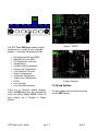
1
GRT S P ORT
Model SX
User’s Guide and Reference
Rev. F
September 2015
Grand Rapids Technologies, Inc.
3133 Madison Avenue SE
Wyoming MI 49548
616-245-7700
www.grtavionics.com
INTENTIONALLY BLANK
GRT Sport User’s Guide
pg. ii
Rev E
FORWARD
Welcome to Grand Rapids Technologies’ GRT Sport! We are pleased that you have chosen our
product to meet your flying needs.
Visit the Grand Rapids Technologies (GRT) website ( www.grtavionics.com ) for the latest
updates and supplemental information concerning the operation of this and other GRT products.
This manual describes the operation of a GRT Dual Screen Sport SX EFIS using the software
version shown in the Record of Revisions. Some differences may be observed when comparing
the information in this manual to other software versions. The Sport SX EFIS may optionally be
equipped with processor upgrade, synthetic vision, vertical autopilot command capability,
ARINC interface, XM weather, internal GPS or 8.4 inch screen. Single display systems are also
available. In the few instances that the operation of other versions or configurations of Sport is
different than that described, those differences are described at the rear of the applicable
chapter. Every effort has been made to ensure that the information in this manual is accurate
and complete. GRT is not responsible for unintentional errors or omissions in the manual or
their consequences.
Copyright © 2001 - 2010 Grand Rapids Technologies or its subsidiaries. All rights reserved.
Information in the document is subject to change without notice. Grand Rapids Technologies
reserves the right to change or improve their products and to make changes in the content of
this material without obligation to notify any person or organization of such changes or
improvements.
CAUTIONS
WARNING: Obstacle clearance is not assured in Synthetic Approach Mode.
WARNING: Various functions of this system may be incomplete or untested. Please exercise
caution when using the EFIS until a software update and a user manual corresponding to the
software version are provided.
CAUTION: If any display unit is inoperable, the display units will not be able to share
information. The pilot must account for this down-graded mode of operation and expect data
will transfer between displays.
CAUTION: If GPS position data is lost for more than 30 seconds, the EFIS Sport issues a No
GPS Position warning and automatically reverts to dead-reckoning using the AHRS heading,
true airspeed, last known winds and time. This data is used to estimate changes in position,
which are applied to the last known GPS position to give an approximate navigation solution.
The accuracy of the dead-reckoning function will degrade with time depending on the accuracy
of this data and changes in the winds.
GRT Sport User’s Guide
pg. iii
Rev E
CAUTION: When the ground track indicator is hollow, indicating it is display-limited, the ground
track indicated is necessarily inaccurate. This means the aircraft’s track over the ground is not
as indicated and the pilot should be aware of this inaccuracy with regard to obstacle and terrain
clearance.
CAUTION: Dual Nav radios tuned to Localizer frequencies with autopilot function ARM
engaged will result in the EFIS Sport selecting either NAV radio to fly the Localizer.
WARRANTY
Limited Warranty
All GRT products include a 2-year warranty starting on the day the instrument is put into service
(or 3 years after purchase, whichever comes first) against manufacturer defect.
REVISIONS
The list of effective pages is provided. In addition, a vertical bar in the left margin identifies text
or graphics that have been changed from the previous edition.
GRT Sport User’s Guide
pg. iv
Rev E
RECORD OF REVISIONS
Rev
A
B
C
D
E
F
Date
11-27-06
4-1-07
2-22-08
9-27-10
9-1-11
10-115
SW Rev
Change(s)
Initial Release
Extensive
Extensive
Extensive
Extensive
Angle of Attack Updated
2b
3
7f
8c
LIST OF EFFECTIVE PAGES
Page
Rev
Page
Rev
GRT Sport User’s Guide
Page
Rev
Page
Rev
pg. v
Page
Rev
Page
Rev
Page
Rev
Page
Rev E
Rev
Table of Contents
CHAPTER 1 TAKE OFF TOUR ............................................................................................... 1-1
1.1 POWER UP ........................................................................................................................................................1-1
1.2 KNOBS AND BUTTONS ........................................................................................................................................1-2
1.3 PRIMARY FLIGHT DISPLAY GROUP ......................................................................................................................1-4
1.4 MOVING MAP GROUP (GPS OPTION REQ’D) ........................................................................................................1-5
1.5 ENGINE GROUP (EIS OPTION REQ’D)...................................................................................................................1-6
1.6 GROUP OPTIONS ...............................................................................................................................................1-7
1.7 MESSAGES ........................................................................................................................................................1-8
1.8 MODEL DIFFERENCES........................................................................................................................................1-8
CHAPTER 2 PRIMARY FLIGHT DISPLAY ............................................................................. 2-1
2.1 USING THE PRIMARY FLIGHT DISPLAY .................................................................................................................2-1
2.2 ARTIFICIAL HORIZON ..........................................................................................................................................2-3
2.2.1 Artificial Horizon .......................................................................................................................................2-3
2.2.2 Synthetic Vision ........................................................................................................................................2-3
2.2.3 Bank Angle Indicator ................................................................................................................................2-3
2.2.4 Pitch Ladder .............................................................................................................................................2-3
2.2.5 Flight Path Marker ....................................................................................................................................2-3
2.2.6 Flight Director ...........................................................................................................................................2-3
2.3 AIRSPEED TAPE .................................................................................................................................................2-4
2.4 ALTIMETER TAPE................................................................................................................................................2-4
2.5 VERTICAL SPEED TAPE ......................................................................................................................................2-5
2.6 HEADING TAPE...................................................................................................................................................2-5
2.7 W IND SPEED/DIRECTION ....................................................................................................................................2-7
2.8 TURN COORDINATOR..........................................................................................................................................2-7
2.9 GPS CDI DISPLAY .............................................................................................................................................2-7
2.10 ANGLE OF ATTACK ...........................................................................................................................................2-8
2.11 SLIP INDICATOR ...............................................................................................................................................2-9
2.12 USER SELECTABLE DATA BOXES ......................................................................................................................2-9
2.13 FIXED DATA BOXES ........................................................................................................................................2-10
2.14 TRIM, FLAP G METER INDICATORS ..................................................................................................................2-10
2.15 CLOCK...........................................................................................................................................................2-10
2.16 OBSTACLE W ARNING......................................................................................................................................2-10
2.17 PFD LOCK .....................................................................................................................................................2-10
2.18 NAV MODE ...................................................................................................................................................2-10
2.19 LAT A/P, VERT A/P, AND ARM .....................................................................................................................2-11
2.20 SYNTHETIC APPROACH...................................................................................................................................2-11
2.21 ILS APPROACH ..............................................................................................................................................2-14
2.22 MODEL DIFFERENCES ....................................................................................................................................2-14
CHAPTER 3 MOVING MAP ..................................................................................................... 3-1
3.1 MOVING MAP - COMMON ABBREVIATIONS AND TERMS............................................................................3-1
3.2 MAP .................................................................................................................................................................3-1
3.3 SELECTING MAP DETAILS ...................................................................................................................................3-2
3.4 MAP SLEW ........................................................................................................................................................3-3
3.5 RANGE SELECT..................................................................................................................................................3-3
3.6 ALTITUDE INTERCEPT ARC ..................................................................................................................................3-3
3.7 FIXES AND INTERSECTIONS .................................................................................................................................3-3
3.8 SURFACE FEATURES (US ONLY) .........................................................................................................................3-4
3.9 NAVIGATION (FLIGHT PLAN) ................................................................................................................................3-4
3.9.1 Direct To Mode .........................................................................................................................................3-4
3.9.2 Plan Mode ................................................................................................................................................3-7
3.9.3 Other Navigation Features .......................................................................................................................3-8
GRT Sport User’s Guide
pg. vi
Rev E
3.10 NEAREST FUNCTION.........................................................................................................................................3-8
3.11 SYNTHETIC VISION ...........................................................................................................................................3-8
3.12 TERRAIN W ARNING ........................................................................................................................................3-10
3.13 OBSTACLE W ARNING......................................................................................................................................3-10
3.14 W EATHER (XM W EATHER MODULE OR NAVW ORKX ADS-B REQUIRED) ...........................................................3-10
3.15 TRAFFIC (GARMIN GTX330 , ZAON XRX OR NAVW ORKX ADS-B REQUIRED) ...................................................3-11
3.16 AUTO-TUNING (GARMIN SL30/40 REQUIRED) .................................................................................................3-11
3.17 ELECTRONIC HORIZONTAL SITUATION INDICATOR (GARMIN SL30 OR ARINC MODULE REQUIRED) ...................3-12
3.18 CLOCK...........................................................................................................................................................3-13
3.19 CHECKLISTS ..................................................................................................................................................3-13
3.20 LOGBOOK ......................................................................................................................................................3-14
3.21 MODEL DIFFERENCES ....................................................................................................................................3-15
CHAPTER 4 ENGINE MONITOR ............................................................................................. 4-1
4.1 FUEL DATA ........................................................................................................................................................4-1
4.2 FUEL TOTALIZER ................................................................................................................................................4-2
4.3 VERTICAL BAR GRAPHS......................................................................................................................................4-2
4.4 DIALS ................................................................................................................................................................4-2
4.5 TEMPS PAGE ...................................................................................................................................................4-2
4.6 EGT PAGE ........................................................................................................................................................4-3
4.7 HIST PAGE .......................................................................................................................................................4-4
4.8 STATS PAGE ....................................................................................................................................................4-4
4.9 DIALS PAGE .....................................................................................................................................................4-4
4.10 SPLIT ENG MAP PAGE ....................................................................................................................................4-5
4.11 ENGINE PAGE SETTINGS ..................................................................................................................................4-5
4.12 VERTICAL POWER ............................................................................................................................................4-5
4.13 MODEL DIFFERENCES......................................................................................................................................4-6
CHAPTER 5 A/P COUPLING .................................................................................................. 5-1
5.1 BENEFITS ..........................................................................................................................................................5-1
5.2 GPS NAV - GPS STEERING ..............................................................................................................................5-1
5.3 AUTOPILOT MODE ..............................................................................................................................................5-2
5.3.1 LATeral A/P .............................................................................................................................................5-2
5.3.2 VERTical A/P (GPSS / GPSV and Vertical Autopilot Commands Option Required) ...............................5-4
5.3.3 ARM .........................................................................................................................................................5-5
5.3.4 Synthetic Approach ..................................................................................................................................5-6
5.4 ALTITUDE PRESETS ..........................................................................................................................................5-11
5.5 MODEL DIFFERENCES ......................................................................................................................................5-11
CHAPTER 6 FLYING THE ILS ................................................................................................ 6-1
6.1 FEATURES .........................................................................................................................................................6-1
6.1.1 LOC/GS ARM Features ...........................................................................................................................6-1
6.1.2 GPSV ARM Function ..............................................................................................................................6-2
6.2 ILS EXAMPLES ...................................................................................................................................................6-2
6.2.1 Vectors to Localizer ..................................................................................................................................6-2
6.2.2 GPS Enroute to Localizer.........................................................................................................................6-2
6.2.3 VOR Enroute to Localizer (Two Nav Receivers)......................................................................................6-3
6.2.4 VOR Enroute to Localizer (One Nav Receiver) .......................................................................................6-3
6.2.5 Back-Course with LOC-REV ARM ...........................................................................................................6-3
6.2.6 Precision Approaches (Glideslope Coupling to Autopilot) ILS Armed .....................................................6-4
6.2.7 Non-Precision Approaches - Stepping Down ...........................................................................................6-6
6.3 MODEL DIFFERENCES ........................................................................................................................................6-6
CHAPTER 7 OTHER FEATURES ........................................................................................... 7-1
7.1 SWAP ................................................................................................................................................................7-1
7.2 POWER UP ........................................................................................................................................................7-1
GRT Sport User’s Guide
pg. vii
Rev E
7.3 FLIGHT DATA RECORDING ..................................................................................................................................7-2
7.4 MESSAGES ........................................................................................................................................................7-3
7.5 UPDATING SOFTWARE ........................................................................................................................................7-4
7.6 MODEL DIFFERENCES........................................................................................................................................7-5
CHAPTER 8 LIMITATIONS ..................................................................................................... 8-1
8.1 ATTITUDE HEADING REFERENCE SYSTEM (AHRS) ..............................................................................................8-1
8.2 HARDWARE........................................................................................................................................................8-1
8.3 MODEL DIFFERENCES........................................................................................................................................8-1
CHAPTER 9 CALIBRATION .................................................................................................... 9-1
9.1 ALTIMETER CALIBRATION....................................................................................................................................9-1
9.2 MAGNETOMETER CALIBRATION ...........................................................................................................................9-2
9.3 TRUE AIRSPEED AND W IND CALIBRATION ............................................................................................................9-5
9.4 FLAP/TRIM CALIBRATION ....................................................................................................................................9-6
9.5 FUEL FLOW TOTALIZER CALIBRATION ..................................................................................................................9-6
9.6 MULTI-DISPLAY UNIT COMMUNICATION ...............................................................................................................9-7
9.7 ANGLE OF ATTACK CALIBRATION ........................................................................................................................9-7
9.8 MODEL DIFFERENCES........................................................................................................................................9-8
CHAPTER 10 SPECIFICATIONS .......................................................................................... 10-1
CHAPTER 11 FAQ ................................................................................................................. 11-1
CHAPTER 12 APPENDIX C: TROUBLESHOOTING ........................................................... 12-1
TERRAIN ................................................................................................................................................................12-1
AHRS/MAGNETOMETER-COMM INTERFERENCE ......................................................................................................12-1
CHAPTER 13 GLOSSARY .................................................................................................... 13-1
GRT Sport User’s Guide
pg. viii
Rev E
Chapter 1 TAKE OFF TOUR
1.1 Power Up
The GRT Sport has no On/Off switch and
will start to operate once power is supplied.
Power may be applied before or after the
engine is started, although it is preferable to
do the latter. This assures stable conditions
and normal system behavior during power
up. About 10 seconds is required for the
display unit(s) to start up and a similar time
for the AHRS and ADC to complete initial
alignment.
Aircraft movement is allowed during initial
alignment, although this motion will
significantly extend the time until attitude
and/or heading data is accurate, thus
making it preferable to remain motionless
during the first 10 seconds after power is
applied.
After power-up, the startup screen will show
software and navigation database version
and GRT system status.
GRT Sport User’s Guide
pg. 1-1
EFIS GRT SPORT Power Up
EFIS Software Integrity Check: XXX
EFIS Software Version: XXXXXXXXXX
AHRS Software Version: XXXXXXXXX
Navigation Database Integrity Check: XXX
Navigation Database Date: XXXXXX
AHRS Communication Check: XX
GPS Communication: XX
EIS Communication: XX
Speed/Distance Units: Knots, nautical miles
Inter-Display Communication: XX
Accept
Startup Screen
To acknowledge the database information,
press the button labeled ACCEPT
Once acknowledged, the default screen
appears (the default screen is a setup option
– see GRT Sport Set Up Manual)
Note: The factory default screen is the
Primary Flight Display (PFD) on Display Unit
1 and Map on Display Unit 2.
Rev E
Screen Brightness
1.2 Knobs and Buttons
The GRT Sport system is designed to make
its use and operation simple. The left and
right knobs and five white buttons are used
to access the many features in the EFIS.
Menu option labels show functions for each
knob and button.
To adjust the screen brightness:
Press the left knob, select DIM. Turn the
knob to adjust.
LAT
A/P
HDG
Buttons
DIM
PFD
MAP
ENG
NAV
Next
ALT
There are five buttons. Pressing any button
will display the corresponding menu options
for that page. (The buttons may also be
called SoftKeys. They correspond to
particular software functions within the GRT
Sport.)
Knobs
The two knobs have two motions, rotary and
push. These provide particular functions on
different pages. (The knobs may also be
called rotary encoders.)
The rotary knobs also perform a variety of
secondary functions that are available by
first pushing the knob to display a menu of
the available functions. The available
functions will be listed above the knob.
Twisting the knob allows you to select from
the menu of functions, and pressing the
knob will activate that function. If no
selection is made from the menu within 4
seconds (SET MENU, Primary Flight
Display, Menu Time Out), the menu is
removed, and the knob returns to its primary
function.
When the rotary knob is altering any setting,
the label of the item being altered is
enlarged, and a flashing yellow box will
appear around the item’s label being altered
GRT Sport User’s Guide
pg. 1-2
Autopilot SoftKeys Shortcut
Pressing the left rotary knob when no
SoftKey labels are displayed on the PFD
page will bring up the SoftKeys used to
control the autopilot mode and related
functions (LAT A/P, VERT A/P, ARM, SAP).
The menus will stay visible until exiting or
deselecting. They will not timeout after the
left knob is pressed.
Menu Option Labels
Labels are blue or green boxes over the
knobs or buttons and describe the function
for that page.
Labels appear when a knob or button is
pressed and disappear after 4 seconds,
(SET MENU, Primary Flight Display, Menu
Time Out) unless another knob or button is
turned or pressed.
Rev E
The selected or active feature is in a white
border while others are within a black
border.
Labels are dependent on the connected
equipment, and may be different than that
shown in this manual.
NAV
MODE
GPS1
GPS2
DIM
GRT Sport User’s Guide
PFD
MAP
ENG
pg. 1-3
NAV
Next
ALT
VRATE
Rev E
1.3 Primary Flight Display Group
The Primary Flight Display-PFD has
selectable pages. Using the button labeled
PFD, you may select the PFD page or one
of six split pages; PFD/MAP Arc (GPS
required), PFD/HSI (SL30 or ARINC
required), PFD/Engine (Engine Monitor
required) or the same three split pages with
expanded engine information at the bottom.
•
•
•
Artificial Runways
Angle of Attack
Flight Director
Engine information is displayed at the
bottom of the screen. This may be toggled
OFF if desired.
LAT
A/P
HDG
DIM
PFD
MAP
ENG
NAV
Next
ALT
PFD Screen
PFD Select
The GRT Sport PFD is the main page used
during flight. It displays the basic six flight
indicators and other information. Displayed
are:
• Artificial Horizon or Synthetic Vision
• Airspeed Tape & Indicator
• Altimeter Tape & Indicator
• Turn Coordinator
• Vertical Speed Indicator
• Heading Indicator
• User Definable Fields
• Heading Select Display
• Flight Track Marker
• Baroset Select Display
• GPS CDI Display
• Wind Indicator
• Ground Track and Waypoint
Bearing Indicators
• Flight Path Marker
GRT Sport User’s Guide
pg. 1-4
PFD/MAP Arc
Rev E
1.4 Moving Map Group (GPS option req’d)
The GRT Sport moving MAP group also has
selectable pages. Pressing the MAP button
cycles the Arc, 3600 and North-up pages.
The HSI page is available only when a
Garmin SL30 or ARINC module is
connected. The same pages are available
with expanded engine information at the
bottom.
LAT
A/P
PFD/HSI
HDG
DIM
PFD
MAP
ENG
NAV
Next
ALT
MAP Select
Displayed are:
PFD/Engine
Sport SX EFIS may be equipped with
Synthetic Vision. If so equipped, the PFD
display may display an “out the window”
view of the terrain ahead. The second
display may display a “top down” view of the
terrain beneath the aircraft. Synthetic Vision
may be toggled “ON” or “OFF”. When
“OFF”, the displays are the same as
described above.
GRT Sport User’s Guide
pg. 1-5
•
•
•
•
•
•
•
•
•
•
•
Navaids
Fixes and Intersections
Airports/Airspace
Surface Features
Heading or Track
GPS waypoint/route data
Weather (optional-GRT Weather or
NavWorx ADS-B required)
Traffic (optional-GX330 transponder,
Zaon Portable Collision Avoidance
System or NavWorx ADS-B required)
Wind Direction and speed
Autopilot settings
Terrain Clearance including Top
Down View with optional Synthetic
Vision
Rev E
•
Altitude Intercept Arc
Engine information is displayed at the
bottom of the screen. This may be toggled
OFF if desired.
3600
Arc
EHSI
The Map group also contains the following
subgroups:
•
•
•
•
North-Up
Flight Planning
Checklist
Map Slew
Log Book
1.5 Engine Group (EIS option req’d)
The GRT Sport ENG group may display full
screen engine information or split screen
ENG/MAP Arc or Vertical Power electrical
system displays. Use the button labeled
ENG to switch views.
GRT Sport User’s Guide
pg. 1-6
Rev E
LAT
A/P
HDG
DIM
PFD
MAP
ENG
NAV
Next
ALT
The GRT Sport ENG page displays engine
parameters in a variety of user selectable
graphics. Parameters displayed include:
•
•
•
•
•
•
•
•
•
•
•
•
•
Revolutions per Minute (RPM)
Manifold Pressure (MAP)
Oil Temperature/ Pressure
Voltage/Amps
Cylinder Head Temperature
Exhaust Gas Temperature
Fuel Flow/Fuel Pressure
Coolant Temperature
Carburetor Temperature
Turbine Inlet Temperature
N1/N2
Lean Function
User Defined Parameters
Engine/ Map Arc
1.6 Group Options
There are six different graphic displays
within the ENG group that are selectable by
using the button labeled DATA. Details of
each display are in Chapter 5, Engine
Monitor.
GRT Sport User’s Guide
Engine - TEMPS
pg. 1-7
To select options within a particular group
use the NEXT button.
Rev E
LAT
A/P
1.8 Model Differences
HDG
DIM
PFD
MAP
ENG
NAV
Next
ALT
High resolution Sport SX displays (HS
model) do not present Synthetic Vision.
Standard resolution legacy Sport WS
displays do not present engine information
at the bottom of the PFD display nor
Synthetic Vision. The airspeed and altitude
tapes are solid color, not transparent.
NEXT Select
1.7 Messages
When a parameter is out of limit or a flight
condition needs attention, the Sport EFIS
will annunciate the problem(s) on the display
and with a MSG label. For example,
OIL P
MSG
Out of Limit Message
Messages are displayed on the all group
pages. Options to remedy the annunciation
are available by pressing the button labeled
MSG. See Chapter 6 for more details.
GRT Sport User’s Guide
pg. 1-8
Rev E
Chapter 2 PRIMARY FLIGHT
DISPLAY
•
•
•
In this section we will show you the
symbology and function within the Primary
Flight Display. At first glance it looks like a
lot of information, you’re right, but in a short
amount of time you will be able to use every
feature with ease.
The Primary Flight Display-PFD has
selectable pages. Using the button labeled
PFD, you may select the PFD page or one
of three split pages; PFD/MAP Arc (GPS
required), PFD/HSI (SL30 or ARINC
required), PFD/Engine (Engine Monitor
required). All four selections are available
with or without expanded engine information
at the bottom
Airspeed Tape with Digital Display
Heading Tape with Digital Display
Vertical Speed Indicator
These are arranged with the Artificial
Horizon in the center, the Airspeed Tape on
the left, the Altimeter Tape on the right, the
Heading Indicator along the top and the
Vertical Speed Indicator next to the
Altimeter.
You will also notice the Pitch Ladder and
Bank Angle Indicators in the center of the
screen, and the Trim/Flap Indicator in the
lower left (under the Airspeed Digital
Display).
The basic PFD page also contains five
boxes which display:
2.1 Using the Primary Flight
Display
•
•
Below is the basic PFD page.
•
•
•
Ground or True Airspeed - upper left
NAV & Lateral Autopilot Mode –
upper left below speed
Heading Select - lower left
Altitude PreSelect & Vertical Autopilot
Mode - upper right
Altimeter/Baroset Setting - lower right
PFD Screen
The basic PFD page consists of the primary
flight instruments:
• Artificial Horizon
• Altimeter Tape with Digital Display
GRT Sport User’s Guide
pg. 2-1
Rev E
Ground/
True
Airspeed
Lateral
Autopilot
Mode
NAV
Mode
Airspeed
Airspeed
Trend
G Meter
Pitch
Ladder
Artificial
Horizon
GPS
Course
Standard Rate
Turn Marker
CHT
EGT
Hgt
Above
Runway
Heading
GPS Track
Aircraft Nose
Flight Path
Pitch Ref
Marker
Slip
Indicator
Course
Deviation
Indicator
(CDI)
Selected
Heading
Man
Press
Altitude
Preset
RPM
Vertical
Speed
Preset
Vert A/P
Mode
Highway In
Sky (HITS)
Altimeter
Vertical
Speed
Wind
Indicator
GPS vs
Altimeter
Hgt
BARO
Set
User
Defnd
Data
Box
Rev E
pg. 2-2
GRT Sport User’s Guide
Heading
Select
User
Defnd
Data
Box
Fuel
Computer
Oil
Press/
Temp
Primary Flight Display
2.2 Artificial Horizon
2.2.3 Bank Angle Indicator
2.2.1 Artificial Horizon
The Artificial Horizon is just that, a pictorial
representation of the earth. The blue portion
represents the sky; the brown portion
represents the ground.
2.2.2 Synthetic Vision
Synthetic Vision is an available option on the
Sport SX. When selected, a 10 mile forward
“out the window” view of the topography
around the current aircraft position is
presented on the PFD and a “top down”
view is displayed on MAP pages When
Terrain is enabled, red (0-500 ft) and yellow
(500 – 1000 ft) warnings are overlaid on the
Synthetic Vision displays.
Selecting Synthetic Vision
SV
A portion of the artificial horizon is the Pitch
Ladder. It depicts pitch angle of the aircraft
in relation to the horizon. It is normally set
(SET MENU, Primary Flight Display, Pitch
Ladder Offset) so that straight and level
flight at normal cruise speed is 0 pitch (bars
align with the horizon).
The Flight Path Marker, shown as a circle
with three spikes is a projection of the
aircraft’s flight path and predicts the future
position of the aircraft based on current
aircraft state parameters (attitude, speed,
wind etc) and assumes they remain
constant. The FPM will appear to float
about the display as the aircraft pitches and
rolls. This movement is most evident in
strong crosswind or unusual attitudes.
2.2.6 Flight Director
ON
Terrain
OFF
2.2.4 Pitch Ladder
2.2.5 Flight Path Marker
To select Synthetic Vision mode, press any
button then NEXT (more than once may be
required) until the SV label appears. The
button under the label will select between
ON (turns on Synthetic Vision), Terrain
(turns on Terrain Warning See Section 3.11)
and OFF (turns off Synthetic Vision and
Terrain Warning and restores brown and
blue background).
DIM
Note that the aircraft “wings or pitch bars”
and the triangular pointer move so the
pointer always points up or towards the sky.
This is called a sky pointer representation
and provides guidance for recovery from
unusual attitudes. This representation is
opposite that of conventional general
aviation attitude indicators.
-------
Set
Menu
GRT Sport User’s Guide
Status
Next
ALT
pg. 2-3
Both Lateral and Vertical autopilot functions
must be enabled in General Setup. The
flight director is controlled by the autopilot
functions even if you don't have an autopilot.
The flight director is activated in the second
step of the altitude selection menu on the
PFD (push the right knob twice). The FLT
DIR button switches the flight director on
Rev E
and off. When active, the wing/nose
indicator is replaced with a yellow upsidedown V at the center and yellow bars to the
side. The computed roll and pitch are
indicated by a magenta V with raised
outside edges. Any active needles will be
replaced with scales to make room. To fly
the flight director, adjust the pitch and roll of
the plane to fit the yellow V into the
magenta V. The indicator shows the same
command sent out to an autopilot. The flight
director has no special indication while on
the ground or during take-off and will show a
level command if a command can't be
computed.
aircraft will be at in 5 seconds. It only
appears if the airspeed is changing.
2.4 Altimeter Tape
2.3 Airspeed Tape
The Altimeter Tape displays altitude above
mean sea level (MSL) in hundreds of feet.
The background color of the altimeter tape
shows the Off Route Obstacle Clearance
Altitude (OROCA) which provides 1000 foot
obstruction clearance in non-mountainous
terrain areas and 2,000 foot obstruction
clearance in designated mountainous areas
within the United States. An altitude below
the OROCA is shown yellow, above the
OROCA is shown green.
The Airspeed tape displays airspeed and
three user selectable speed bugs which
appear as magenta triangles with letters X,
Y, & G for Vx, Vy and Vg. The Bugs are set
in the SET Menu, General Setup, Primary
Flight Display.
To set the barometric pressure value on
the altimeter:
Turn the right knob on any PFD page.
When the desired barometric value is
displayed in the lower right corner, press the
knob to enter.
The background colors of the airspeed tape
are the standard airspeed color segments.
The background color is red above VNE, (the
maximum demonstrated safe airspeed that
the aircraft must not exceed under any
circumstances). It is yellow in the caution
area, from VNO (maximum structural cruise
speed) to VNE. It is green from VS to VNO.
VS is the stall speed with flaps and landing
gear retracted. It is white from VSO to VFE.
VSO is the stall speed with flaps and landing
gear extended, and VFE is the highest speed
at which flaps can be extended. The color is
user selectable to be red or none below VS1.
You may set an altimeter bug or preset
altitude on the altimeter tape to provide a
visual alert of an important altitude. It will
display as two magenta triangles.
Between the airspeed tape and window is
the trend indicator. This is a white arrow that
indicates the direction and rate of airspeed
change and points to the airspeed the
GRT Sport User’s Guide
pg. 2-4
Setting an altimeter bug will also cause a
green arc (altitude intercept arc) to appear
when a MAP page is displayed. The green
arc shows where you will be located when
the preset altitude is reached. This feature
works both in climb or descent. The arc will
move as VSI and speed changes occur. It is
helpful as a backup to monitor progress
towards hitting crossing restrictions or
arriving at pattern altitude (Chapter 3.6).
And finally, a preset altitude serves as the
hold altitude for autopilots with vertical
steering capability (Chapter 5.3.2).
Rev E
To set an Altitude bug:
1. Press the right knob on any PFD
page.
2. Turn knob to desired Altitude
3. Press knob to set.
2.5 Vertical Speed Tape
Just to the left of the altimeter tape is the
vertical speed tape. It shows vertical speed
in feet per minute. The vertical speed is
also presented digitally, at the bottom of the
scale when descending and at the top of the
scale with climbing.
2.6 Heading Tape
A portion of the Heading Tape (70 degrees)
is presented at the top of the display and
displays four parameters:
•
•
•
•
Magnetic Heading (point up triangle
H underneath)
GPS Ground Track (point down
triangle with T underneath)
Bearing or Course to current
waypoint (pair of inverted triangles)
Heading Bug (pair of squares)
The center of the heading tape (position
over the center of the bank indices) is user
selectable to be either Magnetic Heading or
Ground Track. (SET MENU, Primary Flight
Display, Up reference). The display at the
center above the bank indices presents the
same information in numeric format as well
as the label HDG or TRK to indicate the
current selection.
Current Magnetic Heading is displayed on
the Heading Tape as a point up triangle. If
Magnetic Heading is not selected as Up
Reference, the triangle will have an “H”
below it. Its position relative to the Ground
GRT Sport User’s Guide
pg. 2-5
Track indicates the current difference
between ground track and magnetic
heading.
Ground Track, derived from GPS data
(requires a GPS source), is displayed on the
Heading Tape as a point down triangle. If
Ground Track is not selected as Up
Reference, the triangle will have a “T” below
it. Its position relative to the Magnetic
Heading indicates the current difference
between ground track and magnetic
heading.
The Bearing (or GPS Course) to the
currently selected waypoint is displayed on
the Heading Tape as two inverted triangles.
Maneuvering the aircraft so that the ground
track indicator is aligned with this indicator
will result in a ground track directly to the
waypoint if the plane is on the course line.
The Heading Bug is displayed on the
Heading Tape as two side by side squares
and also in the data box above the left knob
(SEL HDG). It is used to manually control
the autopilot or as a visual reminder of
desired heading. The heading bug is set by
turning the left knob on a PFD or MAP page
to the desired heading. Or, to select the
current heading, press both knobs
simultaneously.
Occasionally one or more of the parameters
will be off the Heading Tape, since the tape
display is limited in width to 70 degrees. For
Rev E
example, if there is a change in course at a
waypoint greater than 35 degrees, the
Bearing to the GPS waypoint triangles or
Heading Bug squares or both may be off the
tape.
Likewise if there is a strong
crosswind, the Ground Track triangle and
Magnetic Heading triangle may be more
than 35 degrees different.
When any
parameter is off the tape display, that
parameter is said to be “display limited”.
When a parameter is display limited, the
triangles or squares will be outlines or
hollow, not filled in or solid. Display limited
parameters do occur, but they are an
exception rather than the norm. The GRT
handling of them described below makes
their occurrence a trivial matter.
When a parameter is display limited, it will
be displayed at the left or right end of the
tape. The end chosen is the direction to turn
the aircraft to get the parameter onto the
tape and out of “display limited”.
For
example, if the Magnetic Heading is 270 and
the GPS Ground Track is 220 (strong wind
from the North) the display limited Ground
Track triangle will appear on the left end of
the tape indicating a left turn is required to
get the Ground Track triangle back on the
tape and out of “display limited”.
The relative position between two “display
limited”
indicators
remains
accurate,
allowing the pilot to align them to achieve
the same result as if they were not display
limited.
When the Ground Track indicator is displaylimited, the Flight Path Marker and groundreferenced
symbols
(runways
and
obstacles) are artificially shifted so that they
remain on the screen, but in such a way that
their position relative to each other is
correct. This allows these items to be visible
GRT Sport User’s Guide
pg. 2-6
on the screen no matter how large the drift
angle.
CAUTION: When the Ground Track
indicator is hollow, indicating it is displaylimited; the ground track indicated is
necessarily inaccurate. This means that
the aircraft’s track over the ground is not
as indicated, and the pilot should be
aware of this inaccuracy with regard to
obstacle and terrain clearance.
Should the Flight Path Marker become
“display limited”, it will appear red.
If Lateral Autopilot Functions are ON (Set
Menu, General Setup, Lateral Autopilot
Functions), The Bearing to Waypoint,
Ground Track and Magnetic Heading
triangles and Heading Bug squares will be
either white or magenta. Magenta means
that indicator IS coupled to the autopilot and
white means that indicator is NOT. For
example, when you select LAT A/P HDG
(heading) the Heading Bug squares and the
Magnetic Heading triangle turn magenta
and the Bearing to Waypoint triangles and
Ground Track triangle are white. When LAT
A/P ENAV is selected and a GPS is selected
as the Nav source, the Bearing to Waypoint
triangles and Ground Track triangle turn
magenta and the Heading Bug squares and
the Magnetic Heading triangle are white.
If Lateral Autopilot Functions are OFF (no
autopilot in use), the Magnetic Heading
triangle and Heading Bug squares will be
white and the Ground Track triangle and
Bearing to Waypoint triangles will be
magenta.
Rev E
2.7 Wind Speed/Direction
2.9 GPS CDI Display
The wind speed and direction is available in
two formats as described and selected in the
Primary Flight Display settings page.
The GPS CDI (Course Deviation Indicator)
is located at the bottom center of the screen.
It displays the direction and magnitude of
the GPS cross-track error. The cross-track
error is the distance from the aircraft’s
current position to the line connecting the
previous and next waypoint in the GPS flight
plan. (When only one waypoint is active in
the flight plan, the GRT Sport, like most
GPS navigation equipment, will use the
aircraft’s position at the time the waypoint is
selected as the previous waypoint position
for purposes of calculating cross-track
error).
The vector representation of wind direction
(the arrow drawn on the screen) shows wind
direction relative to the aircraft’s heading. A
wind vector pointing directly up indicates a
tailwind and a vector pointing to the right
indicates the wind is blowing from left to
right.
The numeric display of wind direction is
relative to magnetic north.
If insufficient data exists for calculation of
winds, the wind vector arrow, and digital
data, is blanked (not displayed). Calculated
winds are based on GPS ground track and
groundspeed, and heading and airspeed
data provided by the AHRS. Accurate winds
require accurate magnetic heading and
airspeed data. Calibration procedures to
correct for heading and airspeed errors are
provided, see Chapter 9, Calibration.
In addition to wind direction and speed,
Head/Crosswind components may be
displayed as well (SET MENU, Primary
Flight Display, Digital Head/Cross Wind
Display).
The cross-track deviation is represented by
the deflection of the bar from the center of
the CDI scale. A deflection to the left
indicates the airplane needs to be
maneuvered to the left to get back on
course. The center of the CDI includes a
triangle that points up or down to indicate
TO or FROM the GPS waypoint
respectively. Note: FROM indications result
in reverse sensing for the deviation
indicator, identical to that of a VOR type CDI
indicator. This allows normal sensing when
tracking outbound from a GPS waypoint.
The deviation bar and TO/FROM indicator
are be displayed whenever a GOTO
waypoint is active in the GPS flight plan.
2.8 Turn Coordinator
The Turn Coordinator is depicted at the top
of the pitch ladder and below the heading
window as inverted green triangles. The
GRT Sport calculates the angle of bank
required to make a Standard Rate turn at
the current airspeed. The Turn Coordinator
triangles will spread out or in as the airspeed
increases or decreases.
GRT Sport User’s Guide
pg. 2-7
The scaling of the CDI indicator changes
automatically from 5.0 nm full scale when
enroute, to 1.0 nm full scale in terminal
phase (within 30 nm of the destination), to
0.3 nm during approach phase. Approach
phase can be detected by the GRT only
when Aviation format of GPS data is
provided to the GRT Sport.
Rev E
2.10 Angle of Attack
Angle-of-attack (AOA) refers to the angle of
the local airflow relative to the wing. Since
the wing will stall when the “critical” angle of
attack is exceeded, AOA is useful for stall
warning, and as a means of establishing an
approach speed that accounts for the
current weight of the airplane.
The GRT EFIS can display AOA that is
derived from either a “calculated” or
“measured” source.
The “measured” AOA source refers to use of
the GRT AOA option with a dual port pitot
probe. This method uses the two pressures
from the pitot probe, and the static pressure,
to measure the AOA. This method provides
the most accurate and fastest responding
AOA measurement.
Angle-of-Attack can also be calculated by
the EFIS by combining a variety of sensor
data. AOA calculated in this manner has the
benefit that does not require any dedicated
hardware. The drawbacks are that the
calculated AOA is dependent on proper
functioning of the pitot/static and pitch
attitude data. Also, the accuracy of the
calculated AOA degrades when flying
through rising or descending air.
approach speed), yellow chevrons pointing
up into a yellow circle prompt the pilot to
increase back pressure to reduce speed,
and similarly, red chevrons pointing down
into a red circle prompt the pilot to push
forward to increase speed. When stall is
imminent, the word "PUSH" appears above
the AOA indexer.
The indexer will show a green circle, with no
chevrons, when the angle-of-attack is in the
optimal range.
When the AOA data used to drive the EFIS
screens is based on the “calculated” AOA
data, “EST” (estimated) will appear inside
the indexer circle. Calculated AOA will be
used if no measured AOA data is available,
or if the measured AOA function has not
been calibrated.
WARNING: The use of this indication is
purely at the judgment of the pilot. The
accuracy of this AOA indexer, and its
stall warning, is affected by EFIS sensor
errors and the accuracy of the calibration
procedure. The EFIS calculation of angleof-attack, and the approach AOA indexer
should not be used as the only stall
warning instrument.
The approach AOA indexer will not appear
at low angles-of-attack.
Either type of AOA data may be used to
drive two different indicators on the PFD
screen.
Approach AOA Indexer
This indicator appears just to the right of the
airspeed tape, and shows the angle-ofattack relative to the optimal for approach.
When the angle-of-attack too low (the
airplane is flying faster than optimal
GRT Sport User’s Guide
pg. 2-8
Rev E
The pitch limit indicator was originally
created to give pilots a maximum pitch angle
reference when performing a windshear
escape maneuver. While this may be of little
use for the typical experimental aircraft pilot,
it provides a visual representation of the
proximity to stall. This data also appears on
the wearable HUD smart glasses.
AOA Slightly High – Need to Pitch Down
Barber-Pole Stall Speed Indicator
WARNING: The use of this indication is
purely at the judgment of the pilot. The
accuracy of this information is affected
by EFIS sensor errors and the accuracy
of the calibration procedure. The EFIS
calculation of angle-of-attach, and the
pitch limit indicator should not be used
as the only stall warning instrument.
Audio Stall Warning
A vertical red/black bar is displayed on the
bottom half of the airspeed tape. The top of
this bar corresponds to the stall speed at the
current "G" loading, and is based on the stall
speed entry made in the EFIS, and the
normal acceleration "G's" sensed by the
AHRS.
For versions of the GRT EFIS that include
an audio output, an audio alert is provided
as stall is approached. This alert begins as a
beeping tone that transitions to a solid tone
as the AOA approaches the stall AOA
programmed during the AOA calibration
procedure.
Pitch Limit Indicator
When enabled on the PFD settings page,
the pitch limit indicator appears on the PFD
screen when the angle-of-attack is less than
8 degrees from stall, and goes away when
the angle of attack more than 9 degrees
from stall. The indicator moves downward
toward the nose or bars pitch indicator as
the angle of attack increases. Stall will occur
approximately when this indicator is on the
nose or bar pitch indicator. This indicator will
be limited to 30 degrees pitch to prevent
chasing a pitch limit that could temporarily
be at a very high pitch angle due to high
airplane speed.
GRT Sport User’s Guide
pg. 2-9
2.11 Slip Indicator
The slip indicator works just like a water
level slip indicator.
2.12 User Selectable Data Boxes
There are 2 Data Boxes at the bottom of the
display. Each has four fields. Each field
may be either data or a label. The choices
are extensive ranging from GPS waypoints
to engine parameters. Detailed instructions
are contained in the GRT Sport Set Up
Guide (SET MENU, Primary Flight
Display, Data Boxes).
Rev E
2.13 Fixed Data Boxes
There are 5 data boxes that display ground
speed or true airspeed in the upper left
corner, Lateral Autopilot mode to top right of
airspeed tape, heading selection in the lower
left corner, autopilot altitude selection or
present altitude bug and Vertical Autopilot
mode in the upper right corner and the
baroset in the lower right corner.
2.14 Trim, Flap G Meter Indicators
Aileron and pitch trim and flap position
indicators automatically display on the PFD
page in the lower left side. The data comes
from EIS which can be configured for trim
and flap position using its Auxiliary inputs.
The G Meter will display in the same area. It
can be selected to be always On, On when
a limit is exceeded or Off. Detailed
instructions are in the GRT Sport Set Up
Guide.
2.15 Clock
within a particular group use the NEXT
button. It helps to think about what it is you
are trying to do then select the group the
function may be in. Press NEXT for more
options.
2.17 PFD Lock
The locked selection disables the selection
of other display screens so that it is
impossible to inadvertently select a display
page that does not show attitude, airspeed,
altitude and heading information.
Split
screens that include the PFD information
may still be selected. However, as you cycle
through the split screens, when you reach
the full screen PFD you will be unable to
display any split screen without “unlocking”
the PFD.
To select, press any button then NEXT
(more than once may be required) until PFD
LOCK label appears. The button under the
label will cycle PFD LOCK off and on.
2.18 NAV Mode
If selected in the General Setup menu, a
digital clock is displayed in the top right
portion of the PFD screen. The clock
automatically sets using GPS data and will
show either Zulu or user selected time.
This setting selects the source of data that is
used to provide navigation information to the
pilot on the PFD and map pages as well as
to the autopilot.
2.16 Obstacle Warning
The selections provided will correspond to
the configuration of (what has been wired to)
the system, such as internal GPS, external
GPS and VOR/NAV
Obstacles such as towers are displayed on
the PFD that are within one minute of flight
path (based on current flight data (speed,
direction)) and within 250 feet of the
aircraft’s altitude.
Sections 2.17 through 2.21 describe options
that are selected by the buttons under the
labels. See Section 1.2. To select options
GRT Sport User’s Guide
pg. 2-10
The available Nav Mode selections are
GPS1, GPS2, Nav1 and Nav2. Data sources
may be up to two GPSs (both external or
one internal and one external) and two
external Nav sources.
For example,
GNS430 and SL30 (external GPS and two
external Nav) or Dual SL30 (two external
Nav) or Dual GNS430 (two external GPS
Rev E
and two external Nav). A GPS selection
may be the GPS side of the GNS430 and
the Nav selection may be the Nav side of
the GNS430.
guidance is provided for selected autopilots
and requires the Sport SX be equipped with
optional features. See Chapter 5.3.4 for
details of using SAP with a connected
Autopilot.
For example:
Synthetic Approach provides the following
benefits:
• Enhanced situational awareness
during all landings. Especially helpful
during night landings.
• Emergency means of guidance to the
runway for the VFR pilot who
inadvertently enters IFR conditions.
• Redundant guidance during ILS
approach. The synthetic approach
will duplicate the ILS approach
alignment but is based on different
data (GPS and baro-alt vs. localizer
and glideslope).
• Emergency backup to ILS receiver.
Since the synthetic approach follows
the same path as the ILS and this
path has assurances of obstacle
clearance, it could be used in an
emergency when the ILS is
unavailable.
GPS1 (430 GPS)
GPS 2 (Internal GRT GPS)
Nav 1 (430 NAV-ILS/VOR)
Nav 2 (SL30)
The NAV mode is displayed in the upper left
corner of the PFD display. Green is GPS,
White is Nav 1, Cyan is Nav 2. Yellow is
Caution / Input required / Mode not fully
engaged.
2.19 LAT A/P, VERT A/P, and ARM
LAT A/P and ARM will appear if Lateral
Autopilot Functions are ON (Settings Menu,
General Setup). VERT A/P will appear if
Vertical Autopilot Functions are ON and the
EFIS is equipped with optional features.
Their use is described in Chapter 5. If
Lateral Autopilot Functions are OFF, these
buttons will not appear.
Selecting SAP
2.20 Synthetic Approach
Synthetic Approach (identified as SAP)
mode allows the GRT Sport to provide
lateral and vertical guidance to any runway
contained with the EFIS navigation database
(position data for each end of the runway
must be in the database. The vast majority
of airports in the database have this
information). Vertical and lateral guidance is
provided via the highway-in-the-sky (HITS)
on the primary flight display page and
laterally via the course and GPS cross track
deviation indicators. Lateral guidance is
provided for connected autopilots. Vertical
GRT Sport User’s Guide
To select Synthetic Approach mode, press
any button then NEXT (more than once may
be required) until the SAP label appears.
The button under the label will select
between
ARM
and
OFF.
SAP
DIM
pg. 2-11
ARM
Set
DA
OFF
-------
Set
Menu
Status
Next
ALT
Rev E
Pressing ARM will result in a list of available
synthetic approaches at the airport .in the
flight plan if ALL of the following conditions
are met:
1. The last waypoint in the flight plan is
an airport, and is contained within the
GRT Sport SX navigation database,
or an approach has been selected
and the GRT Sport SX is able to
determine the airport and runway
being used by the approach.
2. The database contains the necessary
information
about
this
airport,
including
runways,
runway
orientation, position, elevation, etc.
3. AHRS, Air Data Computer and GPS
data are valid
The list of available synthetic approaches
shows the runway identifier, the length,
surface type (hard or soft), lighting, and
crosswind component.
The crosswind component is shown as XWind = speed L/R, where the speed is in the
units selected on the GRT Sport SX, and the
L/R indicates a left or right crosswind, such
that a left crosswind indicates the wind is
blowing from left to right when on the
approach.
The GRT Sport SX will list the runways in
order of how closely aligned they are with
the calculated wind direction. Runways that
are predicted to have a greater than 10 mph
tailwind are shown with a yellow
background.
GRT Sport User’s Guide
pg. 2-12
Rev E
The desired runway is selected using the left
knob.
KGRR 08 8501 HARD PCL 12KTS
KGRR 17 8501 HARD PCL XWind 12KTS L
KGRR 35 8501 HARD PCL XWind 12KTS R
Runway
KGRR 26 8501 HARD PCL 12KTS
The selected runway will blink yellow on the
PFD page.
CAUTION: The pilot must not rely on this
data for selection of the appropriate
runway. Wind speed and direction is
usually different on the surface. The GRT
Sport is making its prediction based on its
calculated winds at the time the approach
mode is activated. The accuracy of the
wind calculation is affected by the
accuracy
of
the
pitot/static
measurements, and the calibration of the
magnetometer.
After selecting a runway, a different runway
may be selected using the SAP button
again. The label will now provide a Chg
Rwy option.
After selecting SAP and ARM, “Check barosetting” will be annunciated.
Once the runway and baro-setting are set,
the HITS will appear if able. The HITS may
be behind, above or below depending on
aircraft position relative to the runway.
If the selected runway includes an
associated localizer in the GRT Sport SX
navigation
database,
the
message
Synthetic Approach using Loc Course
GRT Sport User’s Guide
pg. 2-13
will be provided to remind the pilot that the
approach will follow the localizer, and may
not necessarily be aligned with the runway
centerline.
If the approach mode is selected, but the
GPS flight plan does not contain an
approach or an airport as the last waypoint
that can be matched to the GRT Sport SX
database, then the synthetic approach
cannot be activated. The GRT Sport SX will
respond with a message No Airport found
for Synthetic App, and the approach mode
will be turned off.
When the Synthetic Approach is enabled the
height above the runway will be displayed
under the Flight Path Marker in green. This
altitude will flash when below the Decision
Height. The Decision Height comes from
database approach information, if available.
Otherwise, the Decision Height setting in the
SET MENU is used.
Localizer Override
When the localizer is armed, or the Nav
Mode is LOC, the synthetic approach mode
will display the highway-in-the-sky but will
not provide steering nor autopilot coupling.
This is indicated by DISP selection in the
SAP softkey.
Synthetic Approach Path
Lateral steering will be constructed
according to the following list in order of
priority:
1. If an approach has been selected on
the GPS, the synthetic approach path
will match the course into the runway
waypoint. (An approach is a flight
plan that includes guidance to the
Rev E
runway and will include a runway
waypoint, such as RW25.)
2. If no approach has been selected on
the GPS but the last waypoint in the
flight plan is an airport, the pilot will
be prompted to select the runway. If
the runway includes a localizer in the
EFIS database, then the approach
will be constructed to mimic the
localizer, otherwise it will be
constructed to follow the extended
runway centerline.
If no approach has been selected, and the
last waypoint in the GPS flight plan is not an
airport, the synthetic approach is not
available
2.22 Model Differences
High resolution Sport SX displays (HS
model) present the same PFD information
as the Sport SX except Synthetic Vision is
not available.
Standard resolution Sport displays (WS
model) present the same PFD information
as the Sport SX except Synthetic Vision is
not available and engine information is not
displayed across the bottom of the screen.
The airspeed and altitude tapes are solid
rather than outline and airspeed bug speeds
are blue horizontal lines. Vertical speed is
on the tape only; there is no digital readout
of vertical speed.
2.21 ILS Approach
The GRT Sport SX, although a VFR
platform, provides lateral and vertical
guidance on an ILS. Guidance may be in
scales (series of dots at the bottom and side
of the display with a marker showing
position on the scale) or needles (similar to
a conventional CDI) format when a ILS
frequency is tuned on a connected Nav
receiver (requires SL30 or ARINC interface).
Details of using SAP and autopilot to fly an
ILS approach are given in Chapter 6.
To turn on needles or scales setting:
1. Press any button
2. Press NEXT (more than once may
be required)
3. Press SET MENU.
4. Scroll with either knob to Primary
Flight Display.
5. Press knob to select
6. Scroll to ILS Type
7. Press knob to select and change
8. Press SAVE button
GRT Sport User’s Guide
pg. 2-14
Rev E
Chapter 3 MOVING MAP
The Moving Map page(s) provide a top-down view of the world out to the user’s selected range.
Selection of which data is displayed (airports, airspace, NAVaids, fixes and intersections, lakes
& streams, state outlines, roads, railroads and populated places ) at a given range is user
defined from the settings menu (Set Menu, Moving Map, Max XXX range, etc.). This feature
allows the user to declutter long range map displays while providing very detailed short range
map displays.
3.1 MOVING MAP - COMMON ABBREVIATIONS and TERMS
Sel FP
- Selecting a stored flight plan (left knob)
Rev FP
- Reversing a stored flight plan for the return flight (left knob)
Clr FP
- Clears a flight plan (left knob)
ADD WP
- This waypoint will be added to the DIRECT TO list and be the active waypoint
REM K
- GRT suggests Removing K prefix from the identifier
ADD K
- GRT suggests Adding the K prefix to the identifier
Del WP
- Delete waypoint in a flight plan
Insert Before - to insert another waypoint
User WP
- to create a user defined waypoint, either using LAT LON or RNG BRG
LAT A/P
- Lateral Autopilot couples the autopilot to the heading bug (HDG) or the
GPS receiver (NAV) from the PFD page
SAP
- Select Approach - for synthetic approach - select ARM to arm the approach
Chg Rwy
- To choose a different runway
•
3.2 MAP
The MAP group shows:
•
•
•
•
•
•
•
•
•
•
Airports
Airspace
NAVaids
GPS/NAV Course
Heading Select Bug
Fixes (Hi alt, Lo alt and / or terminal)
HSI (requires SL30 or ARINC
interface)
NAV mode status
Wind Direction and Speed
Terrain
GRT Sport User’s Guide
pg. 3-1
•
•
•
•
•
•
•
•
•
Synthetic Vision top down view
(optional)
Lakes & Streams
Lake & Stream Names
State Outlines
Roads
Railroads
Populated Places
Weather (optional)
Traffic (optional)
Weather Radar (optional)
The MAP display is track up or heading up
according to user settings.
Pressing the MAP softkey will cycle the
MAP through the four map view modes:
Rev E
Aircraft symbol at bottom of screen (Arc
View), aircraft symbol in center of screen
(360 deg View), North Up View, and HSI
which overlays an HSI over the center view
map. All four selections are available with or
without expanded engine information at the
bottom.
Airport/NAVaid Selection
A yellow line will appear on the screen from
the airplane to the item (airport / navaid /
airspace) nearest the map up reference.
Map, Arc View
The map depicted on the GRT Sport is
based on the navigation database within the
EFIS. The database within an external GPS
is not used, as this data is not transmitted to
the EFIS.
3.3 Selecting Map Details
On any MAP page except the HSI page,
information about navaids, airports and
airspace in the database is selectable by
pressing the right knob.
This item will be highlighted with a yellow
circle, and basic information about it will be
displayed. Rotating the knob will move the
highlight to the next item nearest according
to its bearing. Clockwise rotation of the
knob causes the yellow line to rotate
clockwise and counterclockwise rotation, the
opposite.
Details for each navaid airport or airspace, if
in the database, are viewable in the Details
page. The Details page will also have
weather information such as METARs if
equipped with the XM or ADS-B weather
data.
Map Details
GRT Sport User’s Guide
pg. 3-2
Rev E
To access the DETAILS function:
1. Press the right knob and
2. Turn the knob to the desired
navaid or airport.
3. Press again to select DETAILS
4. Press again to exit back to the
map page.
Selecting Airspace
Moving the cursor on the map page will
highlight a section of airspace as it passes
over a reference point for that airspace. The
reference point may be the center of the
airspace or the intersection of lines,
depending on how the airspace is
constructed. The class and limits will be
shown in the info box in the lower left corner
of the screen. Labels for all other sections
of airspace (warnings) will be removed while
the cursor is active. The DETAILS page for
an airspace section lists the unabbreviated
information for the airspace. The current
database only knows the type, class, and
limits.
3.4 MAP Slew
The MAP Slew feature allows you to move
the map without changing the map scale.
Note that the slewed displays will be North
up, however, EXIT returns the map as it was
displayed before Slew.
To slew the MAP view:
1. Press any button
2. Press NEXT (more than once may
be required)
3. Press SLEW followed by WEST,
EAST, NORTH or SOUTH.
4. To return to present position press
EXIT`
GRT Sport User’s Guide
pg. 3-3
3.5 Range Select
The map view has user selectable range
views from 1-1000 miles. The time it takes
to display MAP data and clutter on the
display is directly related to the amount of
information being displayed. Terrain slows
the display significantly. So does display of
airports and navaids especially at longer
range views. Judicious use of user settings
in the Moving Map Set Up page provides a
balance of information and display speed.
The selected range represents the distance
from the top of the display to the bottom.
To access the RNG view setting:
1. Press the left knob, the range box
will highlight in yellow and show
the current range selection.
2. Turn the knob to the desired
viewing range.
3. Press knob to set.
3.6 Altitude Intercept Arc
When an altitude bug has been set (see
Chapter 2.4), a green Altitude Intercept Arc
will appear on MAP pages. The Arc shows
the location on the MAP that the aircraft will
be when the “Bug Altitude” is crossed based
on the current airspeed, course and rate of
descent or rate of climb.
3.7 Fixes and Intersections
Fixes and Intersections are displayed as
small white triangles with identifiers. Display
of Fixes and intersections that are in the
navigation database may be enabled or
disabled as desired. Choices are NONE,
ALL, HI (high enroute), LO (low enroute) or
TERM (terminal) waypoints.
Rev E
Display of Fixes and Intersections is
dependent on the Range selected. Clutter
of the display and time to refresh the display
depends on the amount of data being
displayed. Judicious use of user settings in
the Moving Map Set Up page provides a
balance of information and display speed.
To enable or disable display of Fixes and
Intersections:
1. Press any button
2. Press NEXT (more than once may
be required)
3. Under FIX, press NONE, ALL, Hi
LO or TERM as desired.
4. The FIX selection box will vanish
after selection.
3.8 Surface Features (US only)
Surface features (lakes, streams, names of
lakes & streams, state outlines, roads,
railroads and populated places) may be
displayed on the map. Display of these
features is dependent on the Range
selected and user settings in the Moving
Map Set Up page.
Judicious set up
provides a balance of information and
display speed.
Also available is background color other
than black on the moving map.
3.9 Navigation (Flight Plan)
The GRT Sport allows for quick and easy
selection of a waypoint for Direct To
navigation or a series of waypoints for
FLIGHT PLAN navigation. The use of the
navigation features provides:
1. Graphical representation on MAP
page (magenta for the segment you
are currently on, white for segments
planned).
GRT Sport User’s Guide
pg. 3-4
2. Display of waypoint in use and
associated data, such as range,
bearing, ETA etc in data boxes of
PFD.
3. Output of steering information to
autopilot.
Flight Plans or Direct To waypoints may be
entered into the Sport as described in the
following paragraphs. Both Flight Plans and
Direct To waypoints require GPS data. GPS
data is provided either by the optional
internal GRT GPS or by an external GPS
including most panel mount GPS and many
hand held GPS.
If an external GPS is connected and the
Sport is configured for “External Flight Plan
Source” (Set Up Menu, General), Flight
Plans or Direct To waypoints that are
entered in the External GPS will be
presented on the Sport Moving Map and the
three features described above will be
provided for the flight plan from the external
GPS. Since the GRT GPS is not certified for
IFR use, this feature allows the use of an
IFR certified GPS with the GRT Sport in IFR
flight.
To access flight planning functions:
1. From any MAP page press any
button
2. Press NEXT (more than once may be
required)
3. Press PLAN. This will take you to
the DIRECT TO flight planning page.
The center softkey toggles between DIRECT
TO and Seq (Flight Plan) modes and the
current mode is displayed in the blue banner
at the top of the screen.
3.9.1 Direct To Mode
Rev E
Note that Direct To always plans from the
current position to a specified waypoint.
Previously defined waypoints are maintained
in a library so that you can quickly recall
them for reuse.
line from the airplane symbol to the
waypoint and the waypoint data box
on the PFD.
3.9.1.3 To navigate to a nearby waypoint
(airport or navaid):
3.9.1.1 Direct To waypoint library
When you enter a waypoint as described in
the following sections, it is retained in the
Direct To waypoint library. To use that
waypoint again,
1. Press NEXT (more than once may be
required)
2. Press PLAN. This will take you to the
DIRECT TO page.
3. Rotate the right knob to show the
stored waypoints.
4. Select the desired waypoint (white
box around it) by pressing D . The
white D appears to indicate that
waypoint
is
now
the
active
destination.
5. Press EXIT to finish and return to the
MAP page. Note the magenta line
from the airplane symbol to the
waypoint and the waypoint data box
on the PFD.
3.9.1.2 To navigate to a waypoint (airport
or navaid) shown on the MAP,
1. From a MAP page, press the right
knob.
2. Scroll to the desired waypoint.
3. Press right knob. The waypoint
details will show
4. Press ADD WP. The waypoint will be
added to the DIRECT TO list and be
the active destination. The active
destination is shown with a white
D next to it.
1. Press EXIT twice to finish and return
to the MAP page. Note the magenta
GRT Sport User’s Guide
pg. 3-5
1. Press NEXT (more than once may be
required)
2. Press NEAR
3. Press AIRPORT or NAVAID
4. Scroll with either knob to desired
waypoint
5. Press D . The waypoint will be
added to the DIRECT TO list and be
the active destination. The active
destination is shown with a white D
next to it.
6. Press EXIT twice to finish and return
to the MAP page. Note the magenta
line from the airplane symbol to the
waypoint and the waypoint data box
on the PFD.
3.9.1.4 To navigate to a user specified
waypoint (airport or navaid) by typing the
identifier:
1. Press NEXT (more than once may be
required).
2. Press PLAN. This will take you to the
DIRECT TO flight plan page.
3. Press D from the Direct To page.
Use the alpha-numeric buttons to enter the
identifier for the airport or navaid.
4. Press the appropriate button to select
the letter or number for each
character in the identifier.
When pressing the button under a column
multiple times, the cursor moves to the next
letter in that column. When pressing the
button under a different column, the cursor
Rev E
automatically moves to the next space in the
identifier field.
The right knob controls the NEXT function
which moves the cursor to the next space in
the identifier field (needed when identifier
has two consecutive letters the same as in
GRR).
The left knob controls the CLEAR (CLR)
function which removes the letter or number
entered and backspaces to the previous
space in the identifier field.
As you enter letters or numbers, the GRT
Sport will provide lists of identifiers that
contain the letters and numbers entered so
far. This can be helpful if you are not sure of
the identifier.
While entering letters or numbers in the
identifier fields, the left knob controls the
CANCEL function which returns to the
previous DIRECT TO waypoint.
The left knob also controls the EXIT function
which returns to the Direct To page without
saving the entered DIRECT TO waypoint.
When selecting an airport or navaid, the
GRT Sport will automatically ask for the
ICAO prefix identifier K (for North America)
for the airport if it is required. If one has
been entered but is not required the GRT
Sport will suggest removing only the prefix
identifier. A right knob selection, REM K will
show. Similarly, if the prefix identifier K has
been left off, the GRT Sport will suggest
adding it. A right knob selection, ADD K will
show. To add or remove the prefix
identifier: Scroll to ADD K or REM K to
add or remove K for the identifier.
5. Finally,
press
ENTER
when
complete. The waypoint will be added
GRT Sport User’s Guide
pg. 3-6
to the DIRECT TO list and be the
active
destination.
The
active
destination is shown with a white
D next to it.
6. Press EXIT twice to finish and return
to the MAP page. Note the magenta
line from the airplane symbol to the
waypoint and the waypoint data box
on the PFD.
3.9.1.5 To navigate to a user created
waypoint (Latitude / Longitude or Range /
Bearing or Present Position):
1. Press NEXT (more than once may be
required).
2. Press PLAN. This will take you to the
DIRECT TO flight plan page.
3. Press User WP (left knob) from the
Direct To page.
4. Press NEW.
5. Enter characters for the name of your
user created waypoint
6. Press CREATE (right knob).
7. Select either LAT LON or RNG BRG
or USE PP. LAT LON and RNG
BRG allow you to input the actual
data. USE PP uses the present
position of the aircraft for the
waypoint.
8. The left knob or the NEXT button will
step you through the data input fields.
9. When complete, press SAVE (right
knob) to return to the User Waypoints
page. If you wish to use the new
waypoint, press. D . The waypoint
will be added to the DIRECT TO list
and be the active destination. The
active destination is shown with a
white D next to it.
10. Press EXIT to finish and return to the
MAP page. Note the magenta line
from the airplane symbol to the
waypoint and the waypoint data box
on the PFD.
Rev E
contain the letters and numbers entered so
far. This can be helpful if you are not sure of
the identifier.
3.9.2 Plan Mode
Flight Plans always require at least 2
waypoints, the departure and destination.
That is why Flight Plans may be entered
prior to flight and saved for future use.
3.9.2.1 To enter a Flight Plan manually:
1. Press NEXT (more than once may be
required)
2. Press PLAN. This will take you to the
Flight Plan page.
3. Press Add or Insert Before
(depends on position of curser within
the selected Flight Plan)
Use the alpha-numeric buttons to enter the
identifier for the airport or navaid.
4. Press the appropriate button to select
the letter or number for each
character in the identifier.
When pressing the button under a column
multiple times, the cursor moves to the next
letter in that column. When pressing the
button under a different column, the cursor
automatically moves to the next space in the
identifier field.
The right knob controls the NEXT function
which moves the cursor to the next space in
the identifier field (needed when identifier
has two consecutive letters the same as in
GRR).
The left knob controls the CLEAR (CLR)
function which removes the letter or number
entered and backspaces to the previous
space in the identifier field.
As you enter letters or numbers, the GRT
Sport will provide lists of identifiers that
GRT Sport User’s Guide
pg. 3-7
The left knob also controls the EXIT function
which returns to the Plan page without
saving the entered PLAN waypoint.
When selecting an airport or navaid, the
GRT Sport will automatically ask for the
ICAO prefix identifier K (for North America)
for the airport if it is required. If one has
been entered but is not required the GRT
Sport will suggest removing only the prefix
identifier. A right knob selection, REM K will
show. Similarly, if the prefix identifier K has
been left off, the GRT Sport will suggest
adding it. A right knob selection, ADD K will
show. To add or remove the prefix
identifier: Scroll to ADD K or REM K to
add or remove K for the identifier.
5. Continue using Add or Insert Before
to insert all the waypoints.
Note that you can delete waypoints using
Del WP over the left knob; you may insert
another waypoint by pressing the Insert
Before button; or create a user defined
waypoint using User WP over the left knob.
(see
paragraph
3.8.1.5
above
for
instructions on creating waypoints using Lat
Long or Range Bearing)
6. Select SAVE with the left knob, and
press the knob to save the Flight
Plan.
3.9.2.2 Other Flight Plan Entry Options
Other options include, selecting a stored
Flight Plan using Sel FP; reversing a Flight
Plan for the return flight using Rev FP; or
Rev E
clearing (deleting) a Flight Plan using Clr
FP. All three are found over the left knob.
6. Press the button labeled COPY to
copy it to the GRT Sport
Selecting Go to Leg, moves you to that
point in the Flight Plan and is used to edit
the Flight Plan.
To import a flight plan (any GPS format)
from flight planning software on a USB
stick:
3.9.3 Other Navigation Features
In both modes there are five functions
selectable using the right knob: display
waypoint details, activate/deactivate PFD
information (artificial horizon, airspeed and
altitude), toggle between external and
internal flight plans, copy flight plans and
import flight plans.
To turn on PFD artificial horizon,
airspeed and altitude while in the PLAN
pages (for single display systems, this
feature displays basic aircraft control
information while performing flight planning
tasks):
1. From any MAP page press any
button
2. Press NEXT (more than once may be
required)
3. Press PLAN
4. Press right knob and scroll to select
PFD
5. Press right knob to turn on or off
1. From any MAP page press any
button
2. Press NEXT (more than once may be
required)
3. Press PLAN
4. Press right knob and scroll to select
IMPORT
5. Press button labeled UP or DOWN to
select the desired flight plan
6. Press the button labeled LOAD to
copy it to the GRT Sport
3.10 Nearest Function
Pressing the NEAR button brings up options
to select the nearest airport, weather,
Airport
Whthr
NAV
Metar
EXIT
navaid, or METAR.
To use an external source for flight
plans:
1. From any MAP page press any
button
2. Press NEXT (more than once may be
required)
3. Press PLAN
4. Press right knob and scroll to select
EXTERNAL
5. Press right knob to view
Searching for AIRPORT or NAVAID gives
you the choice to add them as waypoint.
You then may select DIRECT TO that
waypoint.
Selecting nearest WTHR
FREQ,or METAR allows you view METARs
(XM WX required) or auto tune a selected
weather frequency.
3.11 Synthetic Vision
Synthetic Vision
GRT Sport User’s Guide
pg. 3-8
Rev E
Synthetic Vision is an available option on the
Sport SX. When selected, a “top down”
view of the topology around the current
aircraft position is displayed on MAP pages
in addition to the forward “out the window”
presentation on the PFD. When Terrain
Warning is enabled, red (0-500 ft) and
yellow (500 – 1000 ft) warnings are overlaid
on the Synthetic Vision display.
Selecting Synthetic Vision
To select Synthetic Vision mode, press any
button then NEXT (more than once may be
required) until the SHOW label appears.
The button under the label will select
between SHADE (turns on Synthetic Vision),
Terrain (turns on Terrain Warning See
Chapter Section 3.9) and OFF (turns off
Synthetic Vision and Terrain Warning,
restores brown and blue background on
PFD and black background on Maps).
GRT Sport User’s Guide
pg. 3-9
Rev E
SHOW
Shade
Terrain
RNG
DIM
PFD
MAP
ENG
OFF
Next
SELECT
DETAILS
Terrain Illustration
RED, terrain is above or within 500 ft below.
YELLOW, terrain is 500 to 1000 ft below
GREEN, terrain is 1000 to 2000 ft below
BLACK, terrain is more than 2000 ft below
BLUE DOTS, terrain in not available or has
not loaded.
3.12 Terrain Warning
Terrain Warning provides a Forward Looking
Terrain Avoidance (FLTA) function which
looks ahead of the airplane along and below
the airplane’s lateral and vertical flight path
and provides suitable alerts (color change) if
a potential controlled flight into terrain (CFIT)
threat exists;
Terrain is available on any of the three MAP
pages. The GRT Sport (without synthetic
vision) uses the terrain database currently
available on the Grand Rapids Technologies
website. Go to www.grtavionics.com for the
latest version.
To enable terrain display,
1. Press any button
2. Press the center button to toggle
SHOW from NONE to TERRAIN.
(Note Terrain must be enabled in the
Moving Map Set Up page).
3.13 Obstacle Warning
Obstacles such as towers are displayed on
the PFD that are within one minute of flight
path (based on current flight data (speed,
direction)) and within 250 feet of the
aircraft’s altitude.
3.14 Weather (XM Weather Module
or NavWorkx ADS-B Required)
XM Weather is an optional feature of the
GRT Sport. When equipped, the MAP page
will
show
precipitation,
lighting,
meteorological conditions, METARs, TAFs,
TFRs and AIRMETS according to your XM
subscription. (GRT Weather module and XM
Weather service required).
The colors displayed correspond to the
location of terrain relative to the aircraft flight
path as follows:
GRT Sport User’s Guide
pg. 3-10
Rev E
Weather provided by NavWorkx ADS-B
receiver is displayed in a similar manner.
3.15 Traffic (Garmin GTX330 , Zaon
XRX or NavWorkx ADS-B Required)
The MAP page is capable of displaying
traffic if a Garmin GTX330 Transponder,
Zaon XRX Collision Avoidance System or
NavWorkx ADS-B receiver is connected to
the GRT Sport. Traffic targets are displayed
as diamonds with relative altitude and
climbing/descending indicators.
XM Weather - IFR Conditions
To enable weather display,
1. Press any button
2. Press the center button to toggle
SHOW from NONE to RADAR.
SHOW displays the latest radar
image.
Another set of buttons will appear.
LIGHTNING, & WINDS allow selection of
this data. LTG show as lightning bolts on
the MAP page and WINDS (aloft) show
similar to the wind arrow on PFD. When
WINDS are selected, pressing the Next
button allows you to select the altitude winds
to be displayed.
Radar may be selected to LOOP. Select
RADAR ON to loop. The range of radar
corresponds to range selected on MAP page
(to 300 miles).
AIRMETS are shown on the MAP page as
red striations surrounded by a red border.
Selecting an airport allows viewing of
METARS and TAF.
Weather and Terrain cannot be displayed
simultaneously (only one or the other).
GRT Sport User’s Guide
pg. 3-11
Traffic
3.16 Auto-Tuning (Garmin SL30/40
Required)
The GRT Sport’s auto tune feature allows
you to SEND LIST, SET COM or SET NAV
frequencies quickly and easily.
To send a frequency list or set a Com or
Nav:
1. Press any button, followed by
MAP
2. Press the right knob to SELECT
DETAILS.
3. Use the right knob to scroll
through the nearest airport or
navaid,
Rev E
4. Press the knob to select the
airport or navaid.
5. Use the sofkeys to SEND LIST,
SET COMM or SET NAV
If navigation to a VOR waypoint is being
used, the HSI will be white (number one
nav) or cyan (number two nav) and a white
or cyan arrowhead and tail that are not
connected will point to the station
This feature will then program your Com or
Nav with the selected frequency in the
standby mode. To use the standby
frequency set it to active in the SL30/40.
3.17 Electronic Horizontal Situation
Indicator (Garmin SL30 or ARINC
Module Required)
The Horizontal Situation Indicator (HSI)
works just like a conventional HSI and is
displayed in the MAP group when the GRT
Sport is connected to a Garmin SL30 or a
GPS or Nav receiver with ARINC interface.
There are up to three pointers displayed,
one HSI and two RMI. The color of the
pointer indicates the Nav source of that
pointer; GPS is Green, Nav 1 is white and
Nav 2 is cyan.
One pointer is always the HSI pointer
incorporating the course deviation bar. It is
assigned to the Nav source currently being
used for navigation (selected Nav Mode).
The right knob manually selects the GPS or
Nav course which is the arrow end (appears
as a cross, with one leg longer than the
other) of the HSI bar. The triangle near the
inner end of the HSI bar flips from the head
to the tail depending if you are flying towards
the selected course or away from it.
Up to two other Nav sources may be
displayed simultaneously as RMI pointers. If
they are VOR sources, white or cyan
arrowheads and tails that are not connected
will point to the station. If GPS is not being
used for navigation but a GPS waypoint has
been input, a green arrowhead and tail that
is not connected will point to the waypoint.
The needles may be connected by setting in
Set Menu, Moving Map, Connect Bearing
Pointers.
The heading bug is displayed as two
squares, magenta if being used for lateral
autopilot guidance or white if not being
used.
GPS track is shown by two dashed lines.
Magenta if used for lateral autopilot
guidance or white if not
In the photo below, GPS course is 153
(location of green arrow and readout in
lower right), the heading bug is 233 (location
of white squares and readout in lower left),
the course to the waypoint is 064 (location of
green arrowhead and readout in top left),
the magnetic heading is 010 and the GPS
track is also 010 (location of magenta bars)
(note wind is from 008 at 25).
If navigation to a GPS waypoint is being
used, the HSI will be Green and a Green
arrowhead and tail that are not connected
will point to the waypoint.
GRT Sport User’s Guide
pg. 3-12
Rev E
There are also codes you can enter, such as
%25% for your current oil pressure, and
%53% for your current baroset, that can be
used like this:
item CHECK OIL PRESSURE - %25%
item SET BAROSET - %53%
The checklist display will look like:
CHECK OIL PRESSURE 64
SET BAROSET 29.92
EHSI
Codes for each parameter are as follows:
3.18 Clock
If selected in the General Setup menu, a
digital clock is displayed in the top right
portion of the MAP screen. The clock uses
GPS for accuracy and will show either Zulu
or user selected time.
3.19 Checklists
In the MAP group the EFIS also provides
customizable checklists.
On your home pc write a notepad file. It
must be saved as a .txt file (standard
notepad format) and titled CHECKLIST.txt.
Checklist format is as follows:
list NAME OF LIST #1
item ITEM #1
item ITEM #2
item ITEM #3
list NAME OF LIST #2
item ITEM #1
item ITEM #2
item ITEM #3
and so on.
Note that there is a space
between item and ITEM.
GRT Sport User’s Guide
pg. 3-13
item RPM - %0%
item EGT 1 - %1%
item EGT 2 - %2%
item EGT 3 - %3%
item EGT 4 - %4%
item EGT 5 - %5%
item EGT 6 - %6%
item EGT 7 - %7%
item EGT 8 - %8%
item EGT 9 - %9%
item CHT 1 - %10%
item CHT 2 - %11%
item CHT 3 - %12%
item CHT 4 - %13%
item CHT 5 - %14%
item CHT 6 - %15%
item EIS VOLTS - %16%
item FUEL FLOW - %17%
item EIS TEMPERATURE - %18%
item CARB TEMPERATURE - %19%
item COOLANT TEMPERATURE - %20%
item HOURMETER - %21%
item FUEL REMAINING - %22%
item FLIGHT TIME - %23%
item OIL TEMPERATURE - %24%
item OIL PRESSURE - %25%
item EIS AUX 1 - %26%
item EIS AUX 2 - %27%
item EIS AUX 3 - %28%
item EIS AUX 4 - %29%
item EIS AUX 5 - %30%
Rev E
item EIS AUX 6 - %31%
item FUEL ENDURANCE - %32%
item FUEL RANGE - %33%
item ENGINE PERCENT POWER - %34%
item EFIS VOLTS 1 - %35%
item EFIS VOLTS 2 - %36%
item EFIS VOLTS 3 - %37%
item ANALOG AUX 1 - %38%
item ANALOG AUX 2 - %39%
item ANALOG AUX 3 - %40%
item ANALOG AUX 4 - %41%
item ANALOG AUX 5 - %42%
item ANALOG AUX 6 - %43%
item ANALOG AUX 7 - %44%
item ANALOG AUX 8 - %45%
item OAT - %46%
item INDICATED AIRSPEED - %47%
item TRUE AIRSPEED - %48%
item VERTICAL SPEED - %49%
item ALTIMETER - %50%
item PRESSURE ALTITUDE - %51%
item DENSITY ALTITUDE - %52%
item BAROSET - %53%
item AHRS ALIGNMENT - %54%
item AHRS STATUS - %55%
item AHRS ATTITUDE STATUS - %56%
item AHRS ALTITUDE STATUS - %57%
item AHRS ROLL - %58%
item AHRS PITCH - %59%
item AHRS HEADING - %60%
item AHRS SLIP - %61%
item AHRS VOLTS 1 - %62%
item AHRS VOLTS 2 - %63%
item AHRS VOLTS 3 - %64%
item AHRS TEMPERATURE - %65%
item FLAPS - %66%
item AILERON TRIM - %67%
item ELEVATOR TRIM - %68%
item ACTIVE WAYPOINT - %69%
item ESTIMATED TIME TO WAYPOINT %70%
item RANGE TO WAYPOINT - %71%
item BEARING TO WAYPOINT - %72%
item GROUNDSPEED - %73%
item WIND SPEED - %74%
GRT Sport User’s Guide
pg. 3-14
item WIND DIRECTION - %75%
item NAV MODE - %76%
item A/P MODE - %77%
item VNAV MODE - %78%
item SELECTED HEADING - %79%
item SELECTED COURSE - %80%
item SELECTED ALTITUDE - %81%
Loading CHECKLIST.TXT into the
display:
Go to a MAP page
Push the CHECK LIST button
Push the SELECT LIST button
Push the IMPORT button
The
display
will
look
for
CHECKLIST.TXT on the USB flash
drive and show the list names.
6. Push YES to accept the new lists or
NO to keep your previous lists, if any.
1.
2.
3.
4.
5.
3.20 Logbook
In the MAP group there is an automatic
logbook function which generates a logbook
entry for each flight. Airspeed greater than
25 knots forces the creation of a logbook
entry.
Recorded in the logbook are:
Date
Origin (Orig)
Destination (Dest)
Flight Hours (Hrs)
Fuel Used (Fuel)
Departure Time (Dep)
Arrival Time (Arr)
Engine Hours (Eng-Hr)
Additional logbook information may be
added by the user include:
VFR or IFR (V/I)
Number of passengers (PAS)
Fuel Added (FA)
Rev E
Oil Added (OA)
The entries will accumulate up to 200 before
the EFIS will overwrite the older entries.
An EDIT option allows
information listed above.
you
to
add
A DOWNLOAD option is provided to
download the entries to a memory stick and
import them into spreadsheet for permanent
recordkeeping and future viewing.
3.21 Model Differences
Synthetic Vision is not available on high
resolution Sport SX displays (HS model) or
standard resolution Sport SX displays (WS
model). All other Moving Map features are
identical.
GRT Sport User’s Guide
pg. 3-15
Rev E
Chapter 4 ENGINE MONITOR
The Engine Monitor Display provides a
graphical presentation of the information
from sensors attached to the Engine
Information System (EIS) and Vertical
Power electrical system monitor /control if so
equipped.
Engine Monitor
The Engine page always shows two dials
(top right), up to six vertical bar graphs
(bottom left) and fuel data (upper right). The
bottom right area has six selectable views.
They are:
•
•
•
•
•
•
Temps (EGT & CHT vertical graphs)
EGT (120 seconds of EGT data and
EGT vertical graph)
History (120 seconds of EGT and
CHT data)
Bars (adds up to 11 more vertical bar
graphs)
Stats (12 predefined statistics)
Dials (adds 2 more dials)
4.1 Fuel Data
The upper left Fuel Data area has two
vertical bar graphs. The left graph shows
fuel quantity as measured by in tank fuel
GRT Sport User’s Guide
pg. 4-1
sensor(s). The green bar(s) provide a visual
representation of fuel quantity. There is a
bar for each tank. At the top of each bar is a
numeric display of the measured fuel
quantity (rounded to nearest gallon).
The right bar graph is the Fuel Totalizer
display and requires EIS Fuel Flow option.
When fuel is added, the total fuel quantity on
board is input to the system either by
manual entry to EIS or by manual entry to
Sport. See Chapter 4.2 for details. The
green bar and the numeric display at the top
of the bar is the current total fuel. It is
calculated by subtracting fuel used, as
measured by the fuel flow transducer(s),
from the manually input total fuel quantity on
board. The calculation is accurate to 1
decimal place.
After fueling, the Fuel Totalizer numeric
display should agree with the sum of the
tank quantities (numeric displays at the top
of the left side bar graph). There may be
minor rounding errors. The Fuel Totalizer
(right) Display has a red diamond on it. The
diamond is the sum of fuel quantity reported
by the tank sensors. It should stay fairly
even with the top of the Fuel Totalizer green
bar. If it goes down faster, it may be an
indication of a fuel system leak causing fuel
in the tanks to be depleted quicker than the
totalizer is calculating
Each bar (tank quantity sensor and Fuel
Totalizer quantity) may display a user set
red line as low fuel warning.
To the right of the totalizer (right bar) graph
is displayed Fuel Flow, Endurance (based
on user input fuel burn rate) and Range
(based on calculated Endurance and current
airspeed). All these require EIS Fuel Flow
option.
Rev E
To the left of the left bar graph is displayed
Fuel Pressure; user choice of Carb temp,
TAS, or MPG/KPL and OAT in both deg C
and deg F.
EIS. This allows the Fuel Totalizer function
of the EIS to be operational as well as that
of the EFIS.
4.2 Fuel Totalizer
4.3 Vertical Bar Graphs
The EIS Fuel Flow option includes an
accurate Fuel Totalizer. Since fuel flow is
accurately measured, it is easy to calculate
how much fuel has been consumed.
Up to six user selectable vertical bar graphs
may be displayed in this area. Each shows
the numeric value of the parameter at the
top and each may have red lines and green
“arcs”. By manipulating the start and end
points, it is possible to arrange them so the
green area would be half way up during
normal operation. This arrangement makes
it easy to quickly verify that all parameters
are normal.
The pilot must update the totalizer so that
the amount of fuel on board at the start of
the flight is accurately known.
To access the Total Fuel function:
1. Press the left knob
4.4 Dials
The Fuel label will show the following:
Up to four dial displays are user
configurable.
The top two are always
displayed. The bottom two may be replaced
with other displays (bar graphs, histograms
etc.)
OK
(Preset number)
(Preset number)
ADJ
The OK option will not make any changes.
Use this if you did not add fuel.
The top number is an adjustable fuel total. If
you add fuel, curser to ADJ and adjust to
the amount of fuel on board. When changed
and accepted this new number will be kept
in memory until it is changed by the user.
The next number down is a user preset fuel
total in the Graphical Engine Display set
menu. If you preset this number to be the
full fuel capacity of the aircraft, and you fill
your tanks, the fuel on board will be this
amount. Adjust the curser to this and press
the button to accept.
Flight time (this flight) displays at the top
between the two dials. Percent power as
determined by the Engine Performance
chart is displayed at the bottom between the
two dials. Total logged time is displayed to
the right of the right dial.
4.5 TEMPS Page
The Temps page shows CHT and EGT
temperatures.
If the EIS is mounted in the instrument
panel, fuel on board may be entered into the
GRT Sport User’s Guide
pg. 4-2
Rev E
EGT Page-LEAN OFF
To access the EGT page:
1. Press a button
2. Press the DATA button to select EGT
Temperature Page
To access the TEMPS page:
1. Press a button
2. Press the DATA button to select
TEMPS
4.6 EGT Page
The EGT page shows Exhaust Gas
Temperatures and is useful for leaning. The
page provides 30-240 user selectable
seconds of CHT and EGT history.
To select the time to be displayed:
1. Press the right knob
2. Rotate to select 30, 60, 120 or 240
seconds of data.
3. Press the right knob again to accept.
The picture below shows the EGT page with
the LEAN function OFF. The last 120
seconds of EGT data is plotted, graph color
corresponding to cylinder color.
GRT Sport User’s Guide
pg. 4-3
With the LEAN function set to LEAN, as
you lean your engine the EGT page will
show the first cylinder to peak surrounded
by a white box. As you continue leaning, the
last cylinder to peak will be shown in a green
box.
You may then enrichen your engine until the
EGT of the cylinder in the white box reaches
the desired temperature.
Then set the LEAN function to NORM. The
numbers then shown are either positive ( )
or negative (-) representing the difference
from peak.
To access the LEAN function:
1. Press a button
2. Press LEAN button to select
LEAN, NORM or OFF
Rev E
2. Rotate to select 30, 60, 120 or 240
seconds of data.
3. Press the right knob again to accept.
EGT Page-LEAN LEAN
The LEAN NORM function shows the
difference
between
the
cylinder
temperatures from the time the NORM
function is pressed.
Engine History
4.8 STATS Page
The LEAN LEAN function shows the
cylinders peak from first to last and their
temperature difference from that point in
time.
The Engine Stats page provides a quick
reference area for a number of different
parameters.
EGT Page LEAN NORM
Engine Stats
4.7 HIST Page
The Engine History page provides both CHT
and EGT history. The page provides 30-240
user selectable seconds of CHT and EGT
history.
4.9 DIALS Page
The Engine Dials page allows certain
parameters to be viewed in a dial format.
Below is an example of this page view.
To select the time to be displayed:
1. Press the right knob
GRT Sport User’s Guide
pg. 4-4
Rev E
4.11 Engine Page Settings
There are two Setting Menus for the Engine
Monitor Display page. The first is the
Graphical Engine Display menu. It provides
settings to customize the bar graphs and
dials on the ENG page.
To access the Engine Monitor settings:
1. Press any button
2. Press NEXT (More than once may be
required)
3. Press SET MENU.
4. Select Graphical Engine Display
with either knob then
5. Press to select.
Engine Dials
4.10 Split ENG MAP Page
It is possible to split pages to display
Engine, Moving Map or PFD pages side by
side at the same time and engine data may
also be displayed at the bottom of the
display on MAP and PFD pages. Many
combinations of PFD, MAP and ENG split
pages are available. Those of interest are
user enabled (Settings Menu, General Set
Up).
The second is the Engine Limits menu. This
page provides settings for all the parameters
to be shown on the ENG page.
To access the Engine Monitor settings:
1. Press any button
2. Press NEXT (more than once may be
required)
3. Press SET MENU
4. Select Engine Limits with either
knob then
5. Press to select
4.12 Vertical Power
Engine/Map
To access this view:
1. Press any button followed by ENG
The Sport EFIS integrates with the Vertical
Power VP-X enabling you to monitor and
control your entire electrical system on the
EFIS display. Features include the capability
to monitor the health of your electrical
system, view and control the status of
individual circuits, and respond to circuit
faults
.
GRT Sport User’s Guide
pg. 4-5
Rev E
4.13 Model Differences
All Engine Monitor features are identical on
high resolution Sport displays (HS model).
Standard resolution Sport displays (WS
model) do not display engine information at
the bottom of a PFD or MAP page.
GRT Sport User’s Guide
pg. 4-6
Rev E
Chapter 5 A/P COUPLING
5.2 GPS Nav - GPS Steering
5.1 Benefits
GRT Autopilot Servos connect directly to the
EFIS and are controlled by the EFIS. Other
autopilots may be controlled by the EFIS
using one of two methods, either GPS Nav
or GPS Steering (GPSS).
The benefits of driving the autopilot from the
EFIS are:
1. The altitude you have selected appears
on the PFD screen, and you get a bug on
the altitude tape to show you where the
autopilot is being driven to.
2. You can couple the autopilot to any
navigation source available to the EFIS
(GPS, VOR, ILS/Glideslope or heading bug
for example).
3. The EFIS can perform capture of the
LOC,
ILS,
or
synthetic
approach,
automatically switching the autopilot mode
to NAV, setting the inbound course,
capturing
the
glideslope,
etc.
all
automatically (just as is done with
commercial airplanes.)
4. Heading select is provided, and also
includes a bug. The autopilot only provides
track select. When the controller says, "turn
to heading 270", he expects you to go to
that heading, not the ground track of 270.
5. More modes are provided, such as
climb/descend to an altitude at a selected
airspeed (very nice, as the airplane cannot
hold a constant climb rate up to higher
altitudes, but climbing at a particular
airspeed is generally what is desired), or
climb/descent at a selected vertical speed,
as well as automatic leveling off at the
selected altitude.
6. The autopilot can be coupled laterally and
vertically to the synthetic approach.
GRT Sport User’s Guide
pg. 5-1
GPS Nav is the simplest and most common
method and most autopilots accept GPS
Nav commands.
In this scheme, the
autopilot is provided GPS waypoints (usually
a sequence of waypoints which make up a
Flight Plan). The autopilot flies the airplane
from one waypoint to the next. GPS Nav
does not anticipate a course change. Thus
when one leg is finished, the autopilot has to
intercept the next leg after over flying the
waypoint.
GPS Nav provides only lateral autopilot
guidance (no vertical guidance).
If the
aircraft has a two axis autopilot with only a
GPS Nav interface, all vertical autopilot
commands (climb, descend, altitude hold,
etc) must be entered into the autopilot
directly.
Most GPS receivers including handhelds like
Garmin GPSMAP 496 provide GPS Nav
data for autopilot use. The GRT Sport is
also capable of providing GPS Nav data to
an autopilot using a serial interface. Most
autopilots accept GPS Nav data.
If GPS Nav mode is being used, the
autopilot must be in flight plan mode.
NOTE: The autopilot must be in the mode
that allows it to follow a GPS flight plan as
if it was connected to a GPS.
Rev E
In GPS Nav mode, the intercept angle to the
localizer is controlled by the autopilot, and
will usually be fixed at 45 degrees.
The GPS Nav mode works well, but does
not allow as precise tracking of the localizer
and synthetic approach as the GPSS
interface, especially in strong, gusting winds.
GPS Steering (GPSS & GPSV). Similar to
GPS Nav, the autopilot is provided GPS
waypoints (usually a sequence of waypoints
which make up a Flight Plan). The autopilot
flies the airplane from one waypoint to the
next. With GPS Steering the autopilot does
not have to intercept the new leg at a
waypoint because it starts an intercepting
procedure before reaching the waypoint so
that when the intercept turn is complete the
aircraft will be on the next leg. With GPS
Steering, the GPS calculates a desired
bank angle for the autopilot to fly. There is
no overshoot of the desired course in any
course change. GPS Steering allows the
autopilot to fly complex patterns such as
holding patterns and DME arcs with
stunning precision. Two axis autopilots that
feature GPSS also may accept vertical
autopilot steering, referred to as GPSV.
Certain TruTrak Flight Systems and Trio
Avionics autopilots accept GPSS and GPSV
commands.
The GRT Sport SX provides GPSS data to
an autopilot when equipped with the optional
ARINC 429 module. The capability to
provide GPSV data is available as an option.
If GPSS mode is being used, the autopilot
must be in GPSS mode. In the case of the
Digiflight II VSGV, lateral (GPSS) and
vertical steering (GPSV) modes are selected
individually.
GRT Sport User’s Guide
pg. 5-2
Autopilots that do not include GPSS typically
include GPS Nav interface which allows
them to follow the GPS flight plan (see
above).
In GPS Nav mode the GRT Sport provides
only lateral autopilot commands. In GPSS
mode, the GRT Sport provides lateral and
autopilot commands to the autopilot and
vertical commands if optionally equipped.
The GRT Sport will provide these
commands even if the autopilot itself does
not support these modes.
GRT Autopilot servos are commanded
directly by the EFIS using serial
communication and do not use GPS Nav or
GPSS / GPSV commands.
5.3 Autopilot Mode
The GRT Sport has four autopilot modes:
•
•
•
•
LATeral A/P
VERTical A/P
ARM
SAP (Synthetic Approach)
5.3.1 LATeral A/P
The Lateral Autopilot, LAT A/P selection
allows the GRT Sport to send lateral
steering commands to the autopilot or GRT
autopilot servos. The commands may be:
HDG, ENAV or GNAV.
HDG couples the heading bug to the
autopilot.
The autopilot will steer the
heading displayed by the bug on the
heading tape.
The Heading Bug is displayed as two side
by side squares on the PFD heading tape
and also in the data box above the left knob.
Rev E
It is used to manually control the autopilot or
as a visual reminder of desired heading.
The Heading Bug is set by turning the left
knob on a PFD or MAP page to the desired
heading. Or, to select the current heading,
press both knobs simultaneously.
To select LAT A/P - HDG:
1. Press PFD button
2. Press NEXT button (more than once
may be required)
3. Press LAT A/P HDG. The Heading
Bug squares and Magnetic Heading
triangle will turn magenta.
NOTE: If HDG mode is selected when the
LOC or ILS is armed, and the autopilot is
being commanded with GPSS commands, the selected heading will be used
to smoothly intercept the localizer. When
GPSS is not used, the angle of LOC
intercept is based on the response of the
autopilot, and is typically 45 degrees.
ENAV, uses input from the Nav source
selected on the PFD page (NAV MODE
softkey) to generate steering commands for
the autopilot. Any of the connected sources
(internal GPS, external GPS, VOR/NAV,
etc).may be used. See Chapter 2.18. The
autopilot will be commanded to steer to the
waypoint on the selected Nav source. Note
that steering is from waypoint to waypoint.
Curved paths such as procedure turns,
holding patterns and DME arcs are not in
GRT Sport User’s Guide
pg. 5-3
the EFIS database and are not commanded
in ENAV mode.
To select LAT A/P - ENAV:
1. Press PFD button
2. Press NEXT button (more than
may be required)
3. Press LAT A/P ENAV button.
Waypoint Course triangles
Ground Track triangle will
magenta.
once
The
and
turn
Note that the Nav souce selected must be
navigating to a waypoint. The autopilot will
be steered to that waypoint
GNAV Since the Sport database does not
contain approach information, the Sport
cannot provide lateral steering for procedure
turns, DME arcs, holding patterns etc.
However, the Garmin 430/530/480 GPS
receivers (with or without WAAS) can
provide GPS position, flight plan data, lateral
deviation, vertical deviation, roll commands,
and mode selection to the EFIS over an
additional ARINC 429 (ARINC GPS)
connection, similar to the VOR/LOC/GS
ARINC connection. This information allows
the EFIS to provide VNAV functions for an
approach and follow roll commands from the
GPS while still controlling pitch commands.
In most installations a switch is provided to
connect the GPS receiver directly to the
autopilot in the event of EFIS failure. With
the GNAV feature, the switch can be left in
the EFIS position unless there is an EFIS
failure.
To select LAT A/P- GNAV:
1. Press PFD button
2. Press NEXT button (more than once
may be required)
3. Press LAT A/P GNAV. The EFIS
passes roll commands from the
430(W)/530(W)/480 to the autopilot.
Rev E
Vertical steering commands are EFIS
generated.
This entry will only
appear when the ARINC GPS Input
setting is configured for the selected
GPS receiver. It will turn gray when
roll commands are not being received
from the GPS. If GNAV is selected
and roll commands are lost, GNAV
LOST will flash on the screen.
5.3.2 VERTical A/P (GPSS / GPSV and
Vertical Autopilot Commands Option
Required)
The Vertical Autopilot, VERT A/P selection
allows the GRT Sport to send vertical
steering commands to the autopilot or GRT
autopilot servos. The autopilot must be
capable of using GPSV vertical steering
commands (such as the TruTrak Digiflight II
VSGV or Trio Pro Pilot autopilot) and the
Sport Vertical Autopilot Commands Option
must be installed.
There are four available vertical autopilot
selections: AUTO, VS, ASPD and VNAV.
In AUTO, VS and ASPD the autopilot will be
steered to the altitude bug setting. When
that altitude is reached, the autopilot will be
commanded to hold that altitude. For
convenience, setting the altitude bug is
incorporated into the VERT A/P selections.
Turning the right knob to set the altitude bug
immediately causes the number to be
changed by 100’s of feet.
Waiting 5
seconds allows the number to be changed
by 10’s of feet.
•
AUTO – This mode commands the
autopilot to climb or descend at the
preset airspeed or the preset vertical
speed (preset speeds are set in
Settings
Menu,
Primary
Flight
Display).
GRT Sport User’s Guide
pg. 5-4
To select VERT A/P - AUTO:
1. Press PFD button
2. Press NEXT button (more than once
may be required)
3. Press VERT A/P – AUTO button
4. Press the right knob to set the altitude
bug.
5. Press the softkey to select the
desired preset speed.
6. Press the right knob again to accept
and exit
•
VS – This mode commands the
autopilot to climb or descend at the
vertical speed (if possible) entered
into the EFIS using the right knob.
To select VERT A/P - VS:
1. Press PFD button
2. Press NEXT button (more than once
may be required)
3. Press VERT A/P – VS button
4. Press the right knob to set the altitude
bug. Press it again and dial in the
desired vertical speed or select a
preset vertical speed.
5. Press the right knob again to exit.
•
ASPD – This mode commands the
autopilot to climb or descend at the
indicated airspeed (IAS) entered into
the EFIS using the right knob, if
possible with the power setting.
To select VERT A/P - ASPD:
1. Press PFD button
2. Press NEXT button (more than once
may be required)
3. Press VERT A/P – ASPD
4. Press the right knob to set the altitude
bug. Press it again and dial in the
desired indicated airspeed or select a
preset indicated airspeed.
5. Press the right knob again to exit.
Rev E
•
VNAV - This mode is selected to
enable manually coupling to the ILS
glideslope. It also is selected
automatically when the glideslope is
captured using ARM ILS.
The Vert A/P mode can be set to VNAV for
manually coupling to the glideslope
whenever ILS localizer is valid (signal is
present). Coupling to the glideslope will not
occur until the airplane is at or above the
glideslope, and localizer is valid.
To select VERT A/P - VNAV:
1. Press PFD button
2. Press NEXT button (more than once
may be required)
3. Press VERT A/P – VNAV button
5.3.3 ARM
When the EFIS Sport is armed, the last
waypoint in the flight plan is an airport and
an ILS or Localizer frequency is tuned, the
EFIS Sport will attempt to automatically set
the EHSI course and perform the coupling,
called capture
NOTE: The ARM selection is not
available unless an ILS or Localizer
frequency is tuned.
attempting to ARM will generate
message TUNE LOC to XXX.X.
the
If the Nav mode is GPS at the time an ILS
frequency is tuned, a second course pointer
is displayed, in white, on the EHSI, allowing
the localizer course to be pre-set. (The GPS
course pointer is being driven by GPS flight
plan data.)
The ARM GPSV function will follow the
ARINC data when available. Upon capture,
the EFIS will use ENAV mode to follow the
lateral and vertical deviations. When the
VNAV mode is cancelled or MISSED is
selected, the EFIS will return to the LAT A/P
mode selected after capture. The EFIS will
preset the LAT A/P return mode to GNAV if
available. The return mode is indicated in
parentheses in the LAT A/P indicator. For
example, LAT A/P can be set to GNAV after
capture to prepare to follow the lateral
instructions of a missed approach procedure
in the 430W/530W when MISSED is
selected. For HDG mode, LAT A/P should
first be set to HDG, and then the selected
heading should be set in preparation for a
missed approach. This sequence must be
done after capture. The missed approach
altitude can be set in the EFIS to also climb
to a specific altitude, regardless of the
mode.
There are two ARM options available:
If the EFIS Sport detects an ILS frequency
has been tuned, but is unable to determine
the inbound course, a caution message, Set
Inbound Course, will be displayed on the
HSI page.
If the GPS flight plan or synthetic approach
indicates the runway being used, and the
database has the ILS frequency for this
runway, ARM will be available, but
GRT Sport User’s Guide
pg. 5-5
•
LOC The ARM LOC mode allows
automatic coupling to LOC (localizer),
or ILS (localizer with glideslope).
•
LOC REV The ARM LOC-REV mode
is provided for flying outbound on the
LOC, or for localizer back course
approaches.
Rev E
The LOC REV selection will reverse the
sense of the LOC deviations displayed on
the PFD and MAP EHSI pages, and
commands to the autopilot, so that the
localizer sensing appears as it does on a
front course. This eliminates the need to
mentally reverse the localizer sense.
To select ARM – LOC or LOC REV:
1. Press PFD button
2. Press NEXT button (more than once
may be required)
3. Press ARM – LOC or LOC REV
button
5.3.4 Synthetic Approach
Synthetic Approach (identified as SAP)
mode allows the GRT Sport to provide
lateral and vertical guidance to any runway
contained with the EFIS navigation database
that includes position data for each end of
the runway. The vast majority of airports in
the database have this information.
Vertical and lateral guidance is provided via
the highway-in-the-sky (HITS) on the
primary flight display page and laterally via
the course and GPS cross track deviation
indicators.
Lateral steering is provided for connected
autopilots (GPS Nav and GPSS). Vertical
steering is provided for selected autopilots
(GPSV).
The Sport Vertical Autopilot
Commands Option must be present.
WARNING: Obstacle clearance is NOT
assured in Synthetic Approach Mode.
5.3.4.1Benefits
Synthetic
Approach
following benefits:
GRT Sport User’s Guide
provides
the
pg. 5-6
•
Enhanced situational awareness
during all landings. Especially useful
for night landings.
•
Emergency means of guidance to the
runway for the VFR pilot who
inadvertently enters IFR conditions.
•
Redundant guidance during an ILS
approach. The synthetic approach will
duplicate the ILS approach alignment,
but is based on different data (GPS
and baro-alt vs. localizer and
glideslope).
•
Emergency backup to ILS receiver.
Since the synthetic approach follows
the same path as the ILS, and this
path has assurances of obstacle
clearance, SAP could be used in an
emergency when the ILS is
unavailable.
5.3.4.2 The Synthetic Approach Path
Lateral and vertical guidance for the
synthetic approach is constructed by the
GRT Sport according to the following list, in
order of priority.
1. If an approach has been selected on
the GPS, the synthetic approach path
will match the course into the runway
waypoint. (An approach is a flight
plan that includes guidance to the
runway, and will include a runway
waypoint, such as RW25.)
2. If no approach has been selected on
the GPS, but the last waypoint in the
flight plan is an airport, the pilot will
be prompted to select the runway. If
the runway includes a localizer in the
GRT Sport database, then the
approach will be constructed to mimic
the localizer, otherwise it will be
Rev E
constructed to follow the extended
runway centerline.
3. If no approach has been selected,
and the last waypoint in the GPS
flight plan is not an airport, the
synthetic approach is not available.
5.3.4.3 Transitioning from Enroute to
Synthetic Approach
If an approach has been selected in the
GPS flight plan, the transition from enroute
to a path that aligns the airplane with the
runway will be inherent in the GPS flight
plan.
The synthetic approach will be
considered captured (causing the synthetic
approach HITS to be displayed) when the
airplane is within 2.5 degrees of the
synthetic approach course, and within 20 nm
of the runway threshold, emulating the
typical capture of a localizer.
If no approach has been selected on the
GPS flight plan, but the last waypoint in the
flight plan is an airport and the pilot has
GRT Sport User’s Guide
pg. 5-7
selected a runway, the GRT Horizon will
override the GPS flight plan or HDG
selection to turn the airplane onto the
extended runway centerline. This will
typically occur when the airplane is within
2.5 degrees of the extended runway
centerline, and within 20 nm of the runway
threshold. A message Synthetic Approach
Captured will be displayed when this
transition occurs, and the GPS CDI, and
course indicator will then be driven by the
synthetic approach, as well as the autopilot.
If capture of the synthetic approach is
attempted close to the runway, the GRT
Horizon will try to predict when it must begin
turning onto the synthetic approach course
based on groundspeed and intercept angle
so that it does not overshoot the course.
Since the response of the autopilot and
airplane cannot be predicted perfectly,
overshoot is possible, and some loss of
accuracy in the initial tracking of the
synthetic approach may be expected. The
following diagram illustrates the synthetic
approach
capture
criteria.
Rev E
If the SA is ARMed close to the
runway, capture may occur
earlier than expected. This
occurs because the EFIS tries
to predict when the turn must be
started in order to capture the
SA course. Depending on the
direction of travel, and speed,
this can result in capture that
begins well outside of 2.5
degrees from the inbound
course.
After synthetic approach
glideslope capture, the
“MISSED” softkey will
appear on the PFD screen.
Press this button and set
engine power to full to
execute a missed approach.
2.5 degrees
2.5 degrees
Capturing the synthetic
approach emulates
capturing a localizer, and
can be performed up to 20
nm from the runway.
Typically the synthetic
approach will be captured
when within the +/- 2.5
degrees of the inbound
course. If capture is
attempted close to the
runway, the EFIS will
attempt to anticipate the turn
and capture will begin prior
to reaching 2.5 degrees of
the course.
2. When the airplane reaches a position where
conditions are suitable, the EFIS will automatically
change the Lat A/P mode to “NAV” (if it isn’t already),
and the EFIS Nav mode to “GPS”. The airplane will
smoothly capture the localizer inbound course if the
intercept angle is 45 degrees or less, and the distance
to the runway is 8 nm or greater..
After SA capture, the vertical autopilot mode will show
SA ARM.
1. Arm the Synthetic Approach (SA). Select the desired
runway if necessary.
The airplane will be steered according to the current
navigation and autopilot mode. SA capture will occur in any
navigation or autopilot mode. If being vectored, select “HDG”
on the Lat A/P mode. If flying the full approach, be sure it is
selected on the external GPS, the EFIS Nav mode is set to
GPS, and the Lat A/P selection is “NAV”.
SA ARM will appear just below the navigation mode on the
EFIS indicating SA guidance will take over when suitable
conditions exist.
20 nm
Intercept Angles of 45 degrees or less, and 8nm or
more from the runway provide the smoothest capture.
The airplane may be flown to intercept the SA at any
intercept angle, but after capture the EFIS will limit
the intercept angles to a minimum of 20, and a
maximum of 90 degrees.
Capturing the Synthetic Approach
Synthetic Approach Capture
GRT Sport User’s Guide
pg. 5-8
Rev E
5.3.4.4 Selecting SAP
To select Synthetic Approach mode, press
any button then NEXT (more than once may
be required) until the SAP label appears.
The button under the label will select
between ARM and OFF.
SAP
DIM
ARM
Set
DA
OFF
-------
Set
Menu
Status
Next
ALT
After selecting SAP and ARM, “Check
barosetting” will be annunciated.
5.3.4.4.1 Automatic Runway Selection
If an approach has been selected in the
GPS flight plan, and the GRT Horizon is
able to determine the airport and runway for
this approach, a message will be generated
confirming the runway selected by the GPS
approach was identified (For example,
Synthetic App using 26L at KGRR). The
selected runway will blink yellow on the
MAP page.
5.3.4.4.2 Manual Runway Selection
Pressing ARM when the navigation mode is
not LOC, and the LOC/ILS has not been
armed will result in a list of available
synthetic approaches at the airport .in the
flight plan if ALL of the following conditions
are met:
1. The last waypoint in the flight plan is
an airport, and is contained within the
GRT Horizon navigation database, or
if an approach has been selected and
the GRT Horizon is able to determine
the airport and runway being used by
the approach.
2. The database contains the necessary
information
about
this
airport,
including
runways,
runway
orientation, position, elevation, etc.
If an approach has not been selected on the
GPS, and the last waypoint in the flight plan
is an airport, the GRT Horizon will provide a
list of the available runways. The list shows
the runway identifier, the length, surface
(hard or soft), lighting, and crosswind
component.
The crosswind component is shown as XWind = speed L/R, where the speed is in the
units selected on the GRT Horizon, and the
L/R indicates a left or right crosswind, such
that a left crosswind indicates the wind is
blowing from left to right when on the
approach.
The GRT Horizon will list the runways in
order of how closely aligned they are with
the calculated wind direction. Runways that
are predicted to have a greater than 10 mph
tailwind are shown with a yellow
background.
The desired runway is selected using the left
knob.
3. AHRS, Air Data Computer and GPS
data are valid
GRT Sport User’s Guide
pg. 5-9
Rev E
Height Above Touchdown is provided when
the Synthetic Approach is enabled. The HAT
will appear below the Flight Path Marker in
green and flash red/green when below the
Decision Height. The Decision Height comes
from database approach information, if
available. Otherwise, the Decision Height
setting in the SET MENU is used.
KGRR 08 8501 HARD PCL 12KTS
KGRR 17 8501 HARD PCL XWind 12KTS L
KGRR 35 8501 HARD PCL XWind 12KTS R
Runway
KGRR 26 8501 HARD PCL 12KTS
5.3.4.7 Synthetic Approach & Localizer
The selected runway will blink yellow on the
PFD page.
CAUTION: The pilot must not rely on this
data for selection of the appropriate
runway. Wind speed and direction is
usually different on the surface. The EFIS
HORIZON is making its prediction based
on its calculated winds at the time the
approach mode is activated. The
accuracy of the wind calculation is
affected by the accuracy of the pitot/static
measurements, and the calibration of the
magnetometer.
After selecting a runway, it may be changed
by using the SAP button again. It will
provide a Chg Rwy option.
5.3.4.5 Highway in the Sky (HITS)
Once the runway and barosetting are set,
the HITS will appear if able. The HITS may
be behind, above or below depending on
aircraft position relative to the runway
5.3.4.6 Height Above Touchdown (HAT)
GRT Sport User’s Guide
pg. 5-10
If the selected runway includes an
associated localizer in the GRT Horizon
navigation
database,
the
message
Synthetic Approach using Loc Course
will be provided to remind the pilot that the
approach will follow the localizer, and my not
necessarily be aligned with the runway
centerline.
When the localizer is armed, or the Nav
mode is LOC, the synthetic approach mode
will display the Highway-In-The-Sky (HITS),
but will not provide steering (via the desired
course and cross-track deviation indicators)
or autopilot coupling. This is indicated by the
DISP selection in the SAP button, and the
lack of synthetic approach mode indication.
The EFIS will give localizer priority over SAP
to produce steering and autopilot coupling.
NOTE: When displaying localizer data
during the synthetic approach, it is normal
to see differences in the guidance
provided by these two dissimilar sets of
data. This difference is most noticeable
when further from the runway. When the
EFIS HORIZON navigation mode is LOC
or ILS, the synthetic approach will still be
based on GPS data (laterally), but its
inbound course will be adjusted by up to
+/- 1.5 degrees to more accurately match
the localizer data.
Rev E
5.3.4.8 No Airport Found
If the approach mode is selected, but the
GPS flight plan does not contain an
approach or an airport as the last waypoint
that can be matched to the GRT Horizon
database, then the synthetic approach
cannot be activated. The GRT Horizon will
respond with a message No Airport found
for Synthetic App, and the approach mode
will be turned off.
displays (WS model) do not require this
option. All Sport EFIS require the ARINC
option be present to provide vertical steering
to an autopilot.
5.4 Altitude Presets
The GRT Sport has one altitude preset,
Decision Altitude.
The altitude window will show on the display
and blink. Waiting 5 seconds allows the
number to be changed by tens of feet.
To set the DECISION ALTITUDE:
1. Press PFD button
2. NEXT button (more than once
may be required)
3. Press SET DA button
4. Press the right knob, SET
To clear a DECISION ALTITUDE:
1. Press PFD button
2. Press NEXT button (more than
once may be required)
3. Press SET DA button
4. Press CLEAR button
5.5 Model Differences
Autopilot Coupling functions are identical on
all GRT Sport EFIS. Sport SX EFIS require
Vertical Autopilot Commands Option be
present to provide vertical steering to an
autopilot. High resolution Sport displays
(HS model) and standard resolution Sport
GRT Sport User’s Guide
pg. 5-11
Rev E
Chapter 6 FLYING THE ILS
6.1 Features
The following examples are suggested
procedures using the EFIS Sport to fly
precision and non-precision approaches,
although your preferences may differ.
6.1.1 LOC/GS ARM Features
The examples assume GPSV vertical
steering is available from your Trio Pro Pilot,
Digiflight II VSGV autopilot or the use of
GRT autopilot servos. (These procedures
apply if your installation does not include this
feature, although you must control altitude
manually, or via manual selections using
whatever vertical autopilot functions are
available directly from the autopilot control
head.)
When the LOC is armed:
• The Nav mode will initially be
unchanged.
• When LOC, ILS or LOC-REV is
armed, a LOC ARMED, ILS ARMED
or LOC-REV ARMED message will
appear just above the Nav mode
indicator. It will be in a yellow box,
just like the A/P-HDG box.
• The localizer course is automatically
set if possible, and a message that
must be acknowledged is provided,
OR, the pilot is reminded to set the
400/500 Garmin GPS receivers output data
to the EFIS that is similar to and processed
the same way as ILS data, enabling the
Sport to command an autopilot for LPV and
LNAV approaches.
The EFIS GNAV Nav mode allows the Sport
/ GPS receiver to command the autopilot for
full approaches. Since the Sport database
does not contain approach information, the
Sport cannot provide lateral steering for
procedure turns, DME arcs, holding patterns
etc.
However, the GNS430(W) /
GNS530(W) / GNS480 databases contain
full approach information. These GPS’s can
provide GPS position, flight plan data, lateral
deviation, vertical deviation, roll commands
and mode selection to the Sport over an
additional ARINC connection (ARINC GPS),
similar to the VOR/LOC/GS ARINC
connection. This information allows the
EFIS to provide VNAV functions for an
approach and follow roll commands from the
GNS430 while still controlling pitch
commands.
GRT Horizon User’s Guide
Note: Disconnect of the ILS autopilot
mode will occur and an "ILS Disconnect"
message will be generated that must be
acknowledged if any of the following
occur.
1. The pilot changes the navigation radio
frequency to a VOR frequency.
2. Failure of the Nav radio.
3. The pilot changes the EFIS navigation
mode.
4. The pilot changes the EFIS autopilot
mode.
5. Other unexpected radio operation.
inbound course
When the LOC is captured:
• The Lat A/P mode will change to
ENAV if it isn't already.
• The EFIS Nav Mode selection will
change to ENAV (or NAV1, or NAV2
depending on which Nav radio is
providing an "ILS Tuned" indication. If
pg. 6-1
Rev E
•
•
both radios are indicating ILS tuned,
then NAV1 will be used).
The ARM label changes to CAPT on
the softkeys.
The Nav mode displayed will be
LOC, ILS, or LOC-REV.
ARM (and ILS coupling) is turned to OFF
automatically:
• At power-up of the display unit on the
ground
• When the Missed button is pressed.
• When the Nav mode is changed by
the pilot, or by no indication of
ILS_TUNED for 2.5 seconds.
pushed. For HDG mode, LAT A/P should
first be set to HDG, and then the selected
heading should be set in preparation for a
missed approach. This sequence must be
done after capture. The missed approach
altitude can be set in the EFIS to also climb
to a specific altitude, regardless of the
mode.
6.2 ILS Examples
6.2.1 Vectors to Localizer
1. Set the LAT A/P mode to HDG. Set
the heading bug to the desired
heading and engage the autopilot.
2. Tune the ILS frequency on the Nav
receiver.
3. ARM , LOC or ILS.
4. Verify the ILS inbound course is set
correctly. (The EFIS Sport will
attempt to set it for you.) To manually
set it, set the Nav mode to LOC or
GPS. This will allow you to set the
LOC course pointer on the EHSI
screen.
5. Fly the airplane using the heading
bug. When the conditions are
suitable, the EFIS Horizon will
automatically change the Nav and
LAT A/P modes to ENAV, and will
capture the localizer smoothly.
When the Glideslope is captured
• The VERT A/P mode becomes
"VNAV" automatically.
Autopilot Mode Changes after capture
• If the pilot changes the LAT A/P
mode to HDG after LOC capture, the
ARM (CAPT) is automatically set to
OFF.
• If the pilot changes the VERT A/P
mode from VNAV after GS capture,
the ARM (CAPT) ILS is automatically
set to LOC.
6.1.2 GPSV ARM Function
The ARM GPSV function will follow the
ARINC data when available. Upon capture,
the EFIS will use ENAV mode to follow the
lateral and vertical deviations. When the
VNAV mode is cancelled or MISSED is
selected, the EFIS will return to the LAT A/P
mode selected after capture. The EFIS will
preset the LAT A/P return mode to GNAV if
available. The return mode is indicated in
parentheses in the LAT A/P indicator. For
example, LAT A/P can be set to GNAV after
capture to prepare to follow the lateral
instructions of a missed approach procedure
in the 430W/530W when MISSED is
GRT Horizon User’s Guide
6.2.2 GPS Enroute to Localizer
pg. 6-2
1. Set the Nav mode to GPS, the LAT
A/P mode to ENAV. Select the
approach procedure on the GPS, and
engage the autopilot. (The approach
procedure will navigate the airplane
to the localizer intercept.)
2. Tune the ILS frequency on the Nav
receiver.
3. ARM LOC or ILS
Rev E
1. Set the Nav mode and LAT A/P
modes to ENAV. Tune the VOR to
the appropriate frequency, and set
the course pointer on the EHSI page.
The autopilot will track the VOR.
2. When near the localizer, set the LAT
A/P mode to HDG.
3. Tune the localizer frequency.
4. Verify the ILS inbound course is set
correctly. (The EFIS Sport will
attempt to set it for you.) Manually set
it on the EHSI page if necessary.
5. ARM the LOC, or set the LAT A/P
mode back to ENAV. Since no LOC
data is valid yet, the EFIS Sport will
hold the current heading, and will
show LOC-ARM. When the LOC
becomes valid, the EFIS Sport will
capture and track the localizer.
4. Verify the ILS inbound course is set
correctly on the EHSI screen. (The
EFIS Sport will attempt to set it for
you.)
5. When the conditions are suitable, the
EFIS Sport will automatically change
the Nav and LAT A/P modes to
ENAV, and will capture the localizer
smoothly.
6.2.3 VOR Enroute to Localizer (Two Nav
Receivers)
1. Set the Nav mode to whichever Nav
receiver is being used for VOR, and
LAT A/P mode to ENAV. Tune the
VOR to the appropriate frequency,
and set the course pointer on the
EHSI page. The autopilot will track
the VOR.
2. Tune the ILS on the other Nav
receiver.
3. ARM LOC or ILS. (Ideally, this
arming should occur before the
localizer is valid to allow time to
verify/set the inbound course in the
next step.)
4. Verify the ILS inbound course is set
correctly. (The EFIS Sport will
attempt to set it for you.) To manually
set it, the Nav mode must be
momentarily changed to LOC, and
then returned to VOR for continued
enroute VOR navigation.
5. When the conditions are suitable, the
EFIS Sport will automatically change
the Nav mode to the other ENAV
(LOC), using whichever Nav receiver
is set to a localizer frequency, and will
capture the localizer smoothly.
6.2.5 Back-Course with LOC-REV ARM
The back-course can be easily flown by
following the same steps as listed above
using LOC-REV on the ARM button. The
EFIS Sport will attempt to automatically set
the course selector to the back-course, but if
it is unable, the pilot should set the backcourse manually. Glideslope coupling to the
vertical autopilot steering will not occur
automatically in LOC-REV mode.
If the back-course is being used for course
reversal via a procedure turn, or hold, the
following steps should be used.
6.2.4 VOR Enroute to Localizer (One Nav
Receiver)
GRT Horizon User’s Guide
pg. 6-3
1. Use the LOC-REV ARM feature to
capture and track the localizer
outbound.
2. When ready, set the LAT A/P mode
to HDG, and use the heading bug to
make a course reversal. When
making
180
degree
direction
changes, the autopilot will make turns
Rev E
in the direction the heading bug is
moved.
3. On the completion of the course
reversal, while flying the inbound leg
to the localizer front course, follow the
procedures above for Vectors to
Localizer to capture and track the
inbound localizer.
6.2.6 Precision Approaches (Glideslope
Coupling to Autopilot) ILS Armed
When the ILS is armed using the ARM
button, the autopilot will automatically
capture the glideslope when the airplane is
at or above the glideslope. The vertical
autopilot/Nav mode displayed in the upper
left corner of the PFD will show G/S Arm,
and then G/S CAPT.
GRT Horizon User’s Guide
pg. 6-4
Rev E
CAUTION: Arming approach here
may result in aggressive
pitch changes.
Glideslope
Captured
Approach Armed
Altitude Hold
Recommended
pe
eslo
Glid
RUNWAY
The synthetic and ILS glideslope will be captured (meaning, the steering to the autopilot will begin following this
guidance) when the airplane flies above it, and, in the case of the ILS, the localizer is valid and is less than +/- 2
dots. Similarly, the synthetic approach will capture the glideslope when the synthetic approach is captured, and
the airplane flies above the synthetic glideslope.
If the guidance is armed above the glideslope, the glideslope will be immediately captured, but autopilot
commands may result in aggressive pitch changes to bring the the airplane down onto the glideslope.
The recommended method to capture the glideslope is to approach this glideslope in altitude hold mode. This will
result in the smoothest transition onto the glideslope. Capture of the glideslope will be allowed no matter what
Vert A/P mode is selected however.
It is necessary to set engine power to control airspeed on the approach.
Capturing the Glideslope
Glideslope Capture
When the ILS has not been armed, the
glideslope can be coupled by selecting a
vertical autopilot mode of VNAV. The EFIS
Sport will wait until the airplane is at or
above the glideslope before it captures. The
vertical autopilot/Nav mode displayed in the
GRT Horizon User’s Guide
upper left corner of the PFD will show G/S
Arm, and then G/S CAPT.
A/P Coupled Approaches - Momentary
Loss of Localizer or Glideslope
pg. 6-5
Rev E
When flying an approach where localizer
data is coupled to the autopilot, and the
EFIS navigation mode is LOC or ILS
(meaning that valid localizer data has been
provided to the EFIS and the EFIS was
coupling the localizer data to the autopilot),
localizer data could be lost. This is indicated
by the localizer_valid indication provided by
the Nav radio. If localizer data is lost, the
EFIS will automatically change the autopilot
mode to LOC-HDG xxx, and will hold the
heading at the time the localizer data was
lost. When valid localizer data returns, the
EFIS will resume localizer coupling.
displays (WS model) do not require this
option. All Sport EFIS require ARINC option
be present to provide vertical steering to an
autopilot.
Similarly, if glideslope data is lost, as
indicated by the glideslope_valid provided
by the Nav receiver, the EFIS will hold the
vertical speed at the time the glideslope is
lost, and will resume glideslope coupling
when valid glideslope data returns.
6.2.7
Non-Precision
Stepping Down
Approaches
-
The vertical autopilot modes provide a
convenient method to control the altitude on
the non-precision approach. Set the VERT
A/P mode to either AUTO or VS. Select the
desired step-down altitude, and vertical
speed for the descent. The autopilot will
descend and hold the selected altitude.
NOTE: The VERT A/P ASP (airspeed)
mode is not recommended for approach.
6.3 Model Differences
Autopilot Coupling functions are identical on
all GRT Sport EFIS. Sport SX EFIS require
Vertical Autopilot Commands Option be
present to provide vertical steering to an
autopilot. . High resolution Sport displays
(HS model) and standard resolution Sport
GRT Horizon User’s Guide
pg. 6-6
Rev E
Chapter 7 OTHER FEATURES
DIM
PDF
MAP
ENG
Swap
Next
ALT
7.1 Swap
The SWAP feature is available in the Dual
GRT Sport Package. This allows the
information to be swapped from one display
to other since one display unit is an S200
Primary Flight Display and the other is the
S100 Engine and Map.
SWAP ONLY switches displays and
function. It does NOT switch electronic
circuitry and redundant electronic circuitry
does not exist in GRT Sport. For example, if
the electronic circuitry in the PFD unit fails,
PFD information will NOT swap to the MFD
display.
SWAP is useful if the second display is not
conveniently located in front of the pilot. By
SWAPing, the pilot can easily observe and
enter data into the remote display and then
SWAP again to restore the PFD display in
front of him.
To SWAP display information:
1. Press any button or knob
2. Press Next (more than once may
be required)
7.2 Power Up
7.2.1 Ground Power Up
The GRT Sport will turn on once power is
supplied.
When an Aircraft On Ground (AOG) powerup occurs the startup screen will show
software and navigation database version
and GRT system status.
EFIS GRT SPORT Power Up
EFIS Software Integrity Check: XXX
EFIS Software Version: XXXXXXXXXX
AHRS Software Version: XXXXXXXXX
Navigation Database Integrity Check: XXX
Navigation Database Date: XXXXXX
AHRS Communication Check: XX
GPS Communication Check: XX
Speed/Distance Units: Knots, nautical miles
SAP
DIM
ARM
-----
OFF
SET
DA
Set
Menu
Status
Next
Accept
ALT
Startup Screen
To acknowledge the database
information:
Press the button labeled ACCEPT
3. Press Swap
GRT Horizon User’s Guide
pg. 7-1
Rev E
Once acknowledged the default screen
appears per the user’s preset selection.
Note: The factory default screen is
the Primary Flight Display (PFD).
LAT
A/P
HDG
DIM
PFD
MAP
ENG
NAV
Next
ALT
7.2.2 In Flight Power Up
An In-Flight power-up occurs when the
following is true:
•
Airspeed greater than 50 mph
and/or GPS-reported groundspeed greater than 25 mph.
2. Press DEMO button to select
RECORD. (The recording will begin
and a message will remind you to
stop the recording before turning off
the power to the display unit.)
An In-Flight power-up will result in the
display unit showing the same screen as
was selected when the display unit was last
powered down. The startup screen will not
show.
DEMO
7.3 Flight Data Recording
Play
The GRT Sport allows you to record flights
and engine data using the DEMO feature.
Record
This feature will record flight and engine
data which can be played back on the
display unit. The engine data can be
converted and downloaded to a spreadsheet
format for analysis using the EIS Log
software.
3. To stop the recording locate the
DEMO button and press STOP. Be
absolutely certain that a memory
stick is in a DU prior to pressing
STOP. Data is written to internal
memory during the flight, and is
transferred to the memory stick when
STOP is pressed.
The USB memory stick must be in a MFD to
record flight data.
To record a flight using DEMO feature:
1. Press any button then NEXT (more
than once may be required)
The amount of internal memory available will
affect Flight Data Recording.
All data
available in the system is recorded. So if
Terrain, WX and airports/navaids out to max
GRT Horizon User’s Guide
pg. 7-2
Rev E
range are enabled, more data is created per
second than if those options are disabled.
Since the amount of memory is limited,
disabling options will allow a longer data
acquisition time. The size of the memory
stick only has to be larger than the internal
memory.
A typical message will look something like
this: OIL P meaning oil pressure is out of
limit. Pressing the MSG button will display
options to answer the message.
OIL P
Automatic DEMO Modes
MSG
The DEMO recorder can be configured to
automatically start and stop on a few
conditions.
The recording will also
automatically restart based on time and file
size. Restarts are saved with +n appended
to the original file name, where n is a
number that increments with each restart. If
the current date and time are available, the
EFIS can be configured to save files with the
date and time in the name. The settings are
in a new "DEMO Settings" menu at the end
of General Setup.
OIL PRESSURE TOO LOW
SHOW
HELP
ACK
EXIT
INHIBIT
7.4 Messages
When a parameter is out of limit or a flight
condition needs attention the GRT Sport
EFIS will annunciate the problem(s).
These messages are displayed on the all
group pages. Options are presented to
remedy the annunciation by pressing the
MSG button.
If a warning light is connected, problems will
also cause that light to illuminate.
If a CO Guardian is connected, it will
annunciate on the GRT Horizon as a
warning showing the PPM of CO.
GRT Horizon User’s Guide
In the example the oil pressure is out of limit,
too low. The EFIS will provide five options
to choose from.
SHOW — pressing and holding the SHOW
button will display the engine menu so that
you can view the alarm source.
HELP — pressing and holding the HELP
button will display a help banner.
ACK — momentarily pressing the ACK
(acknowledge) button will make the
message go away. The alarm has been
pg. 7-3
Rev E
momentarily silenced but will annunciate
again if the parameter continues to exceed
the limit.
INHIBIT — pressing INHIBIT will bring up
more options to silence the alarm.
The INHIBIT options are:
FLIGHT – pressing FLIGHT will silence the
alarm for the duration of the flight.
15 MIN – pressing 15 MIN will silence the
alarm for 15 minutes then will annunciate if
the parameter is still out of limit.
Flash Drive (Memory Stick) Preparation:
1. Plug the flash drive into your
computer. Windows XP and Vista
should recognize it automatically.
Earlier versions will require a driver.
2. The flash drive will appear as a
removable disk.
Use Windows
Explorer to delete any files on the
flash drive. The flash drive is ready
to use.
Copy the newest SportUp.dat or Nav.DB file
to the main directory of the USB flash drive.
Installation on the EFIS display unit:
1 MIN – pressing 1 MIN will silence the
alarm for 1 minute then will annunciate if the
parameter is still out of limit.
NO INHIBIT – pressing NO INHIBIT will take
you back to the previous menu.
1. Go to the SET MENU by pressing the
button corresponding to this item on
the menu. This item is one of the last
few items on the PFD page. Press
the NEXT button to see more menu
items.
7.5 Updating Software
The navigation database and software in
GRT Sport Up are updated using the same
procedure, as described below.
The
software updates loaded by this procedure
will update the display unit software
immediately, and one additional step allows
any update to your AHRS to be completed.
Updated software is available on the GRT
website (www.grtavionics.com) . Follow the
instructions in the Support, Software section
to select and download the correct file for
your EFIS.
A USB flash drive (memory stick) is supplied
with your GRT Sport and is used to transfer
files from your PC to the EFIS. The EFIS
may not be compatable will all brands of
USB flash drives, so test any flash drives
prior to use.
GRT Horizon User’s Guide
pg. 7-4
2. Use the knobs to move the cursor to
Display Unit Maintenance and push
a knob to activate that menu.
3. Use the knobs to move the cursor to
Load EFIS Software or Load
Navigation Database and push a
knob to select the item.
4. Rotate the same knob clockwise to
activate the EFIS upgrade or
Navigation
Database
upgrade
page.
5. Insert the USB flash drive into the
USB connector on the back of the
display unit, or into the panel mount
USB connector if you have one.
6. Wait for the EFIS to detect the USB
flash drive and download files. The
Rev E
faster when detected and when data
is being copied. The light will blink
slower when the operation is
complete
EFIS may take up to one minute to
detect the USB flash drive. The light
on the USB flash drive should blink
faster when detected and when data
is being copied. The light will blink
slower when the operation is
complete.
7. When the EFIS has completed
copying files from the USB flash
drive, the display unit will reboot.
8. Remove the USB flash drive.
9. When the display unit boots up, verify
that the Power Up page displays the
new EFIS software version.
The progress of the update will be
displayed. Typically 5-10 minutes will
be required to update AHRS
software.
Upon completion, the
display unit may erroneously report
the AHRS failed to restart. Ignore
this message. The AHRS should be
running with its new software. The
software version can be verified
elsewhere on the AHRS maintenance
page.
AHRS Software Upgrade
1. Go to the SET MENU by pressing the
button corresponding to this item on
the menu. This item is one of the last
few items on the PFD page. Press
the NEXT button to see more menu
items.
7.6 Model Differences
All Sport EFIS perform functions described
in this chapter identically.
2. Use the knobs to move the cursor to
AHRS Maintenance and push a
knob to activate that menu.
3. Use the knobs to move the cursor to
Load AHRS Software and push a
knob to select the item.
4. Rotate the same knob clockwise to
activate the AHRS upgrade page.
5. Insert the USB flash drive into the
USB connector on the back of the
display unit, or into the panel mount
USB connector if you have one.
6. Wait for the EFIS to detect the USB
flash drive and download files. The
EFIS may take up to one minute to
detect the USB flash drive. The light
on the USB flash drive should blink
GRT Horizon User’s Guide
pg. 7-5
Rev E
Chapter 8 LIMITATIONS
difficulty in holding a heading after a turn is
completed.
8.1 Attitude Heading Reference
System (AHRS)
8.2 Hardware
The AHRS is subject to an angular rate
maximum of 200 deg/second. If this limit is
exceeded, the AHRS Unreliable message
will be displayed. The air data (airspeed and
altimeter) will remain valid however, attitude
data will not be.
The AHRS may take up to 180 seconds to
align during initial startup. During the first 10
seconds after power-up the aircraft should
remain motionless, after that you may move
the aircraft as desired. The Align message
will show on the screen with the time
remaining for alignment. Once the process
is complete the artificial horizon will display
Maximum Angular Rate in one all axis
simultaneously: 200 degrees/second
Maximum Indicated Airspeed: Per Label on
PFD
Maximum Altitude: Per Label on PFD
Operating Voltage Range:
Display Units
Per Label on
8.3 Model Differences
There are no differences in Limitations of
any of the Sport EFIS models.
AHRS/ Air Data computer software is
independent of EFIS software. The software
versions are designated by the form 0.XX to
distinguish them from EFIS software.
The AHRS /Air Data computer system
provides attitude, airspeed and altitude data
that is not dependent on external data such
as GPS to perform these functions. GPS
data is not used to aid the AHRS, and thus
the loss of GPS data will have no effect on
the AHRS. The AHRS does use airspeed
data (but not altitude data) to improve the
accuracy of its attitude data.
Loss of
airspeed data will only slightly degrade the
accuracy of the attitude data, and will not
significantly alter the integrity of the data.
Thus, the AHRS may be operated without
an
airspeed
(pitot/static)
connection.
Inaccurate airspeed data could result in
noticeably inaccurate attitude data during
turns and for a short time after a turn. In IFR
conditions this will be observed as a
GRT Horizon User’s Guide
pg. 8-1
Rev E
The accuracy of the altimeter can be adjusted
using entries provided on this page to account
sensor errors that may occur due to aging.
menu and Altimeter Calibration from
this menu.
1. Using the left knob, highlight the
Altimeter Calibration – OFF
selection.
2. Toggle this to (Initiate)ON.
3. Set the baroset to the currently
reported altimeter setting.
4. Select Altimeter Bias. Adjust the
setting until the altimeter matches
the airport elevation. (Note that
there is about a 2 second delay
until adjustments are reflected in
the displayed altitude.)
5. Use the buttons to exit.
The adjustments are stored within the
AHRS/Air Data Computer. This means that is
not necessary to enter these corrections into
other display units that use data
Calibration is complete! Do not alter any other
altitude settings. The altimeter calibration will
be turned off automatically when this page is
exited.
9.1.1 Partial Altimeter Calibration
Correcting Altimeter vs Baroset
–
9.1.2 Full Altimeter Calibration – Using Air
Data Test Set
This calibration adjusts the relationship
between the altitude display, and the
barometric pressure setting. This calibration
does not require an air data test set, and may
be performed on an annual basis, or as
needed as follows:
This calibration adjusts the relation-ship
between the altitude display, and the
barometric pressure setting using an Altimeter
Test Set.
Chapter 9 CALIBRATION
9.1 Altimeter Calibration
When the AHRS is to be used for IFR flight, the
altimeter portion of the AHRS must be
calibrated to conform to FAR 91.411. This is to
be done at an interval in time as dictated by
FAR 91.411. It is not necessary to calibrate the
altimeter more often than this requirement.
Position the aircraft at a location with a known
elevation.
1. Turn on the GRT Sport and allow at
least 5 minutes to elapse before
continuing.
2. Obtain the current barometric pressure
setting. This setting should be provided
by the airport at which the airplane is
located, or a nearby airport, and should
be as recent as possible.
3. Select the Altimeter Calibration screen
by selecting SET MENU from the button
GRT Horizon User’s Guide
pg. 9-1
1. Turn on the GRT
least 5 minutes
continuing.
2. Connect test set to
ports of the AHRS.
3. Set the test set
Sport and allow at
to elapse before
the pitot AND static
to sea level (0').
NOTE: Failure to connect the test set to
the pitot connection will damage the
airspeed sensor in the AHRS, and any
mechanical airspeed indicators which are
also connect to the pitot/static system
under test.
Rev E
4. Set the baroset to 29.92 on the GRT
Sport display unit. Turn the right knob to
set baroset.
5. From the display unit which contains the
AHRS (PFD), select the Altimeter
Calibration page in the Settings Menu
6. Verify the baroset is 29.92.
7. Use the left knob to select (blue box)
and press the knob to highlight (white
box) the BIAS field.
8. Temporarily adjust the BIAS on this
page until the altimeter reads 0 ft.
9. Set the altimeter test set to 30,000 ft.'
10. Note the GRT Sport altimeter reading.
11. Calculate the scale factor as follows:
Calculate the Altitude Error as:
Altitude_Error =
GRT Sport_Altimeter_Reading with test set at
30,000 ft.
If the GRT Sport altitude is less than 30000 ft,
the Altitude Error is negative.
Calculate the Pressure Error by multiplying
the Altitude Error by 0.819. The result will be
a negative number.
(Current GRT Sport software may show
ERROR next to Calibrate. This can be
ignored.)
12. Set the altimeter test set back to sea
level (0 ft')
13. Set the BIAS so that the altimeter reads
0 ft.
14. Complete the calibration by setting the
altimeter test set to each altitude listed
on the calibration page (5000, 10000,
15000, etc.), and adjusting the
corresponding entry until the altimeter
reads this altitude.
The accuracy of the scale factor adjustment
can be verified by noting a small altitude error
(less than 200 feet) is observed with a zero
correction at 30,000 feet.
15. Adjust the 30,000 foot correction until
the altimeter reads 30,000 feet.
16. Exit the calibration page.
17. Calibration is complete.
If necessary, the BIAS adjustment can be
made without affecting the other corrections at
any time.
9.2 Magnetometer Calibration
If the GRT Sport altitude is greater than 30000
ft, the Altitude Error is Positive.
Calculate the Pressure Error by multiplying
the Altitude Error by 0.795. The result will be
a positive number
The scale factor is then calculated as follows:
Alt Scale Factor = 42012 / (42012 + Pressure
Error)
Magnetometer calibration is required to
achieve accurate magnetic heading readings.
This calibration corrects for errors induced by
magnetic disturbances local to the sensor,
such as ferrous metal objects.
Before performing this procedure, the
magnetometer location should be validated as
follows:
The result should be a number greater than
0.9744, and less than 1.0255
Set the Alt Scale Factor as calculated.
GRT Horizon User’s Guide
pg. 9-2
Rev E
Note: The magnetometer must be installed
according to the mounting instructions
provided with the magnetometer.
1. Scroll to Magnetometer Calibration
2. Press knob to select
3. While on this page, rotate the airplane
360 degrees. A red graph will appear on
this page showing the errors showing
the calculated errors.
9.2.1 Magnetometer Location Validation
Select the AHRS Maintenance screen by
selecting SET MENU from the button menu
and AHRS Maintenance from this menu, and
locate Magnetic Heading field on this screen.
(Do not use the heading data shown on the
heading tape on the PFD is the gyro slaved
heading, which responds slowly to magnetic
heading changes).
Observe this reading and verify it does not
change by more than +/- 2 degrees while doing
the following:
1. Turn on and off any electrical equipment
whose wiring passes within 2 feet of the
magnetometer.
2. Move the flight controls from limit to
limit.
3. If the magnetometer is located within 2
feet of retractable landing gear, operate
the landing gear.
If greater than +/- 2 degree change is noted,
either relocate the magnetometer or offending
wiring or metallic materials. Recheck.
Before
performing
the
magnetometer
calibration
procedure,
the
approximate
accuracy of the uncorrected magnetic heading
data must be checked.
While the calibration procedure can remove
errors as large as 125 degrees, accuracy is
improved if the location chosen for the
magnetometer requires corrections of less than
30 degrees.
9.2.2 To check the accuracy
uncorrected magnetic heading:
GRT Horizon User’s Guide
of
the
pg. 9-3
If errors of greater than 30 degrees are
observed, this may be caused by magnetic
disturbances near the magnetometers, such a
ferrous metal, magnetic fields from electric
motors, or if the magnetometer orientation is
not the same as the AHRS. (For every 1
degree
of
misalignment between the
magnetometer and the AHRS, approximately 3
degrees of heading error can be expected.)
If errors greater than 30 degrees are noted,
either relocate the magnetometer or offending
wiring or metallic materials. Recheck.
9.2.3 Calibration Procedure
NOTE: The AHRS will not allow
magnetometer calibration to be initiated if
the airspeed is greater than 50 mph to
prevent inadvertent selection while in flight.
If calibration is successful, the existing
calibration data (if any) will be replaced with
the new corrections.
The Magnetometer Calibration page will
guide you through this procedure with its onscreen menus.
The steps you will follow are:
1. Point the aircraft to magnetic north, in
an area without magnetic disturbances,
such as a compass rose.
A simple means of pointing the airplane
toward magnetic north is to taxi the airplane
slowly and use the GPS ground track to
Rev E
determine when you are taxiing in a
magnetic north direction. Make small
corrections to the direction of travel of the
airplane, and continue to taxi for several
seconds for the GPS to accurately
determine your ground track. The GPS
cannot determine your track unless you are
moving.
2. After
the
aircraft
is
positioned
accurately, turn ON the GRT Sport. (If it
was already on, then turn it OFF, and
then back ON again.)
3. Allow at least 1 minute for the AHRS to
fully stabilize.
4. Activate the magnetometer calibration
function by selecting the AHRS
Maintenance Page, and highlighting the
Magnetometer Calibration selection.
5. Change this setting with the knob to
select the Magnetometer Calibration
page.
6. Press Start.
7. Answer the question,Yes.
8. Verify the airplane is still pointed to
magnetic north, and answer the
question Is the airplane, AHRS, and
magnetometer pointed north? with
Yes.
A message will appear at the bottom of the
screen indicating the system is waiting for the
gyros to stabilize.
9. Wait until this message is replaced with
the message, Calibration in Progress,
and immediately (within 15 seconds)
begin the next step.
10. Rotate the aircraft 360 degrees plus 20
degrees in a counter-clockwise manner
(initially towards west).
The airplane does not need to be rotated in
place, but simply pulled or taxied in a circle.
The airplane must be rotated completely
through 360 degrees, plus an additional 20
degrees past magnetic north, within 3 minutes
after initiating the calibration. The airplane
should be rotated slowly, such that it takes
GRT Horizon User’s Guide
pg. 9-4
approximately 60 seconds for the complete
rotation.
If calibration is successful, the AHRS will restart itself automatically, and begin using the
corrections. While re-starting, the AHRS data
will not provide data, and this will result in the
AHRS data disappearing from the display unit
for about 10 seconds.
If calibration is unsuccessful, one of two things
will happen.
1. It will exit calibration mode, and will
show Calibration INVALID - Maximum
correction exceeded if a correction of
greater than 127 degrees is required.
(Invalid - OVERLIMIT will be shown on
the AHRS maintenance page next to the
Magnetometer Calibration field.
A correction of greater than 127 degrees can
be caused by incorrect mounting of the
magnetometer,
or
location
of
the
magnetometer too close to ferrous metal in the
aircraft, or starting with the airplane not pointed
toward magnetic north or magnetometer wiring
errors.
2. If the airplane is rotated too rapidly, the
calibration will not end after the airplane
has been rotated 380 degrees. In either
case, the calibration procedure must be
repeated.
The accuracy of the magnetometer calibration
can now be verified.
1. Point the airplane toward magnetic
north.
2. Turn ON the AHRS (if already ON,
turn it OFF, and then back ON).
3. Verify the AHRS (on AHRS
Maintenance page) shows
a
heading close to north. (Small errors
are likely to be a result of not
Rev E
positioning the airplane to the exact
heading used during magnetometer
calibration.)
4. Select
the
Magnetometer
Calibration page. (Do not activate
the calibration this time.)
5. Rotate the airplane through 360
degrees, and inspect the Calculated
error graph (the red line) drawn on
the screen.
The magnetic heading errors should be less to
5 degrees, and can typically be reduced to
about 2 degrees. Accurate magnetic heading is
required for the AHRS to display accurate
heading data, and to allow accurate wind
speed/direction calculations.
The graph will also show the correction stored
in the AHRS as a green line. The green line will
be within the +/- 30 degree range if the
magnetometer was mounted in a good
location, and was mounted accurately with
respect to the AHRS.
The status of the magnetometer correction
data is indicated by the field next to the
Magnetometer Calibration setting on the
AHRS Maintenance page, if the field has the
message (Change to open page), then valid
data is stored within the AHRS.
Valid data means that the data is present, but
the accuracy of this data is not assured. The
accuracy is dependent on how carefully the
user performed these steps.
Calibration is complete.
9.3 True Airspeed and Wind
Calibration
The GRT Sport accurately calculates indicated
airspeed via its measurement of the difference
between pitot and static pressures.
Typical instrument errors are less than 2 mph
at 100 mph, and diminish to less than 1 mph at
200 mph. It is not uncommon for airspeed
errors to be observed however, as the
pressures provided by the aircraft's pitot/static
system does not always represent the actual
static and impact pressures.
The GRT Sport provides a means of correcting
the true airspeed that it displays in the PFD
data box, and which is used in the wind
calculation. Since the wind calculation is based
on the difference between GPS groundspeed,
and true airspeed, it is quite sensitive to true
airspeed errors, and for some airplanes a
significant improvement in the accuracy of the
winds can be achieved by performing this
calibration.
The GRT Sport does not provide any means to
correct the indicated airspeed, as this would
result in the GRT Sport showing a different
indicated airspeed than other indicators that
may be installed in the airplane.
The AHRS Maintenance page provides a
True Airspeed Corrections selection. When
selected, a correction table is shown, over-laid
on the PFD screen. The table allows for up to 8
corrections. It is recommended that at least the
following 3 airspeeds be used for the
corrections: correction at the typical cruising
speed, typical climb airspeed and typical
approach speed. For example, with an RV-6, a
good approach speed might be 80 mph with
flaps at 1 notch. Additional corrections can be
entered if desired, especially if TAS errors are
noted that vary significantly with speed. Only
one correction for a specific airspeed should be
made.
To record a TAS correction:
GRT Horizon User’s Guide
pg. 9-5
Rev E
1. Press any button or knob.
2. Press NEXT (more than once may be
required)
3. Press SET MENU button
4. Scroll with either knob to AHRS
Maintenance
5. Scroll to True Airspeed Corrections
6. Press knob to select
7. Turn knob to open calibration page
8. Select a blank table entry in the
correction table using a knob.
If no entries are blank, then select an entry and
press Delete to clear the entry. The Start Cal
button will be displayed when the cursor box is
on a blank entry.
9. Press the Start Cal button to begin.
10. Find a heading such that the ground
track indicator is aligned with the
heading indicator on the PFD or map
pages within 5 degrees. This will result
in the airplane flying directly into, or with
the wind.
11. Establish the desired IAS for the
correction. Do not change the power
setting until the calibration is complete.
12. Press the Ready button.
The GRT Sport will average the data until the
on-screen count-down timer reaches 0.
13. Maintain constant heading and altitude
until the count-down timer reaches 0.
14. Turn to the reciprocal heading when
prompted.
15. When established on this heading, at
the same altitude and power setting as
in step 11, press the READY button.
The data will be collected until the count-down
timer reaches 0. The correction table will then
display this correction.
16. Process is complete
GRT Horizon User’s Guide
pg. 9-6
If you feel that an entry is inaccurate, it may be
deleted by selecting it with the cursor box using
the knob, and pressing the DELETE button.
You will be asked to confirm deletion of this
entry before it is erased.
These entries can be saved using the GRT
Sport Settings Backup selection on the
display unit maintenance page. They may also
be manually entered if desired using the EDIT
function.
9.4 Flap/Trim Calibration
See General Setup, Flaps and Trim
Calibration. This setting assumes electric
flap/trim servos are installed (input thru EIS,
see Install and Set Up Manuals). Follow the on
screen instructions.
9.5 Fuel Flow Totalizer Calibration
The fuel flow totalizer (fuel quantity) can be set
on the EIS engine monitor, or the GRT Sport
display unit.
If the EIS is mounted in the instrument panel, it
is used to set the fuel quantity whenever fuel is
added to the airplane. This data will be
transmitted to, and displayed on all display
units to which it is connected.
If the EIS is not mounted in the instrument
panel, the fuel quantity can be set on any
display unit, but only if the fuel quantity in the
EIS is reporting zero fuel. If the display unit
detects a change in the fuel quantity reported
by the EIS fuel flow function, it will use this
data, overriding the user selection made on the
display unit. By setting EIS fuel quantity to
zero, it assures the EIS reported fuel quantity
will not change.
The fuel flow calibration must be set in the EIS,
via its FloCal entry. See EIS manual for more
detail.
Rev E
9.6 Multi-Display Unit Communication
The display units share information; this allows
user selections that affect the entire system to
affect all display units, such as the altimeter
setting for instance.
The following items are updated in all display
units whenever this data is changed in any
display unit.
•
•
•
•
•
•
•
•
Altimeter Setting
Heading Selection
Selected Altitude
All autopilot modes and selections,
including ARMing of approaches
Navigation Mode
Synthetic Approach On/Off
Fuel Flow Totalizer
Alarm Acknowledgements
Other data may also be shared between
display units using the Inter-Display Link menu
on the General Setup screen. See the section
User Settings, General Setup, for more
information.
adjusted so that the EFIS stall warning occurs
at the desired AOA threshold.
Making the Adjustment
Select "Settings" Menu, and "PFD Setup".
Select "EFIS Angle of Attack" to ENABLED.
Next, locate the "Angle of Attack Pitch Offset"
setting. If you have never adjusted this setting,
the AOA Pitch Offset will show "Uncalibrated Change to Calibrate" or "X - Change to
Calibrate" if calibration has been previously
completed.
Note: The AOA indexer and pitch limiter
function is inhibited until calibration has been
performed, even if the EFIS Angle of Attack
function has been enabled.
To calibrate:
1. Change this entry to start calibration. The
EFIS will return to the PFD screen, and will
show the pitch limit indicator and AOA indexer
on the screen, with the right knob showing
"ADJUST" and a value above it.
2. Start with the airplane at least 5000' above
the surface. Slow the airplane and extend
flaps. Reduce power to idle and establish
gliding flight.
CAUTION: If any display unit in the chain
is inoperable, the display units will not be
able to share information. The pilot must
account for this down-graded mode of
operation as necessary and expect data
will not transfer between displays.
3. Gradually slow the airplane and note the
speed at which stall occurs.
4. Resume gliding flight and slow the airplane
to within 1 or 2 mph of stall. Use the right knob
to adjust the pitch limit indicator until it is on
nose or bar pitch indicator.
9.7 Angle of Attack Calibration
Calibration
The EFIS requires user-calibration account for
the AOA at which stall occurs for the particular
wing. This is accomplished by adjusting the
"AOA Pitch Offset" setting. This setting is
GRT Horizon User’s Guide
pg. 9-7
5. If the EFIS detects it is equipped with the
AOA module, it will prompt you to perform
additional steps to calibrate this module also.
Follow the on-screen prompts to complete this
process.
Rev E
6. Press the "EXIT" softkey to end calibration.
Calibration must be repeated if the display unit
(which includes the AHRS) is remounted in a
different orientation.
9.8 Model Differences
There are no differences in Calibration of any
of the Sport EFIS models.
GRT Horizon User’s Guide
pg. 9-8
Rev E
Chapter 10 SPECIFICATIONS
PHYSICAL
Please refer to www.grtavionics.com ,
Products, Flight Instruments, Sport for the
latest dimensions and weights.
POWER
Input:12 Vdc (9-18V, less than 1 amp)
28 Vdc (optional) (18-36V, less than 1
amp)
INTERFACES
RS-232 serial
GRT Horizon User’s Guide
pg. 10-1
Rev E
Am I able to connect a Horizon display and
a Sport display using the Display Unit Link?
Chapter 11 FAQ
What is the difference between the GRT
Horizon and Sport?
The Horizon is built for Instrument Flight Rules
(IFR) flying. It accepts a wide variety of radios,
gps and autopilots. The autopilot command
functions built into the Horizon allow for lateral
and vertical coupling to the autopilot. This
permits “hands-off-stick” flying much like
current and future technology airliners.
GRT recognizes that most flying is not hard
IFR. Not every pilot needs the Horizon HX
redundancy and features. With this in mind we
set out to design a system built on our legacy
Sport's success, the Sport SX, for experimental
and lightsport aircraft.
The Sport SX is designed to provide a low-cost
EFIS (electronic flight information system) with
room for growth and expansion with optional
ARINC-429, faster processor, vertical autopilot
commands, shaded color map, and synthetic
vision. Yes, synthetic vision. The Sport SX with
synthetic vision has 10 miles forward visibility,
shaded color mapping, and terrain collision
warning.
If you like to fly hard IFR with an automated
cockpit your choice will likely be the GRT
Horizon. If you fly on fair weather days mostly
with occasional light IFR your choice will likely
be the GRT Sport.
No. The Display Unit Link is only between like
GRT EFIS, for example up to two Sport
displays or multiple Horizon displays only. The
Display Unit Link is not provided for a Sport
and a Horizon display system.
What is the most important feature of the
GRT Sport?
The most feature of the GRT Sport is the high
integrity AHRS that is independent of GPS or
pitot-static for attitude solution. What good are
attitude data, and the GRT, if you can't trust it?
Why not use mechanical instruments?
Of course you still have that option, but the
GRT EFIS is similar in price, does not have
display representations limited by mechanical
movements, does not require periodic
maintenance, and includes automatic crosschecking of its data. Clearly the days are
numbered for mechanical gyros, and in fact
they no longer exist in many commercial and
military aircraft.
How does this GRT compare with the other
EFIS systems?
There are 3 “levels” of differences.
The First Level
What do I do if I want to upgrade to the
Horizon?
The obvious differences are the size and
functionality.
All we require to upgrade to the GRT Horizon
is the cost difference, send the Sport back and
we will ship a Horizon in its place.
This size of the display unit is large enough to
allow the artificial horizon to look "natural", that
is, like a synthetic view of the outside world
(complete with airports and obstructions), and
still have room for both tapes and large digital
displays of airspeed and altitude.
GRT Horizon User’s Guide
pg. 11-1
Rev E
At the same time, the size is small enough to
allow multiple display screens. Since each
multi-function display unit can display any data
(primary flight data, moving map, graphical
engine data, or a split screen of any 2), the use
of 2 display units provide twice as much
viewable data, while at the same time, adding
redundancy. This also allows for a simple
means to expand your system to meet future
avionics needs.
The functions of our GRT are extensive,
including major functions such as integrated
navigation/attitude displays on the wide-format
primary flight display, graphical engine
monitoring, moving map, and also including
interfaces to the autopilot, localizer and
glideslope inputs, and weather and traffic.
Clearly the functionality and size is far beyond
that provided by other units. The difference in
architecture, that is, the ability to use multiple
display
units
independently,
vastly
distinguishes us from single screen systems.
Those familiar with commercial jets may notice
a similarity between the architecture (and
functionality) our equipment, and that of
commercial jets. This is no accident, as the
chief engineer's background included 10 years
experience in the aerospace industry.
This first level is where the functionality that
results in efficient and safe automation of the
cockpit is built in.
The Second Level
These differences are more subtle. They
include such things as wide-temperature range
operation, direct sunlight readability and
hardware designed specifically for aircraft use.
The design of this hardware is based on the
design principles developed over 12 years of
experience with the Engine Information System
(EIS) line of engine monitoring and more than
20 years of aerospace experience. This results
GRT Horizon User’s Guide
pg. 11-2
in a robust design that has excellent tolerance
for real-world exposure to wiring errors, radio
and electromagnetic fields, etc.
By comparison, other manufactures will use
displays not viewable in direct sunlight, or their
system may operate only over a limited
temperature range, or may be limited by low
maximum angular rates, incomplete interfaces,
lack of built-in test functions or data validation,
and further may operate in "unconventional
manners".
This second level is the level where the quality
is designed in.
The Third Level
These details are usually unseen, but are what
distinguishes aviation equipment from nonaviation equipment. It includes not only the
selection of components suitable for use in an
aircraft environment, but also relies on a failure
modes and effects analysis. This analysis
results in design features and functions (such
as built-in-test functions) that add integrity.
High integrity means a low probability of an
undetected failure of any of the flight critical
data provided to the pilot.
This third level is the level where safety is
designed in.
Conclusion
In the simplest terms, the difference between
us and the others is the engineering and flying
experience upon which our system is
designed. The GRT Sport provides aerospace
grade design, at kit plane affordable prices.
Removed
Rev E
Can I really see it in direct sunlight?
Absolutely!
Why not
save
the
cost
of
the
magnetometer, and make this optional?
Without a magnetometer, GPS data is required
for calculation of attitude. Bad or loss of GPS
data would cause unexpected loss of attitude
data, and would reduce the integrity of the
attitude data, and would reduce the
performance of the GPS/AHRS cross-check.
Why not build the EIS into the GRT for its
engine monitoring functions?
The EIS provides a full time, easy-to-read
display of engine data. This makes a single
GRT display unit completely practical. Without
the EIS, a second GRT display would be
required to allow full time display of engine
data.
Engine
monitoring
requires
numerous
connections to the engine and its sensors.
Each of these connections is exposed to high
levels of electrical noise, and has the potential
of electrical faults introducing unexpected
voltages to them. Bringing signals of this type
into the GRT has the potential for adversely
affecting the GRT, and thus reducing its
integrity.
The EIS provides a convenient backup for
altitude and airspeed data if desired.
For multiple display screen configurations, the
EIS may be remotely mounted.
How did you solve the technical issues with
an AHRS, when your main background
appears to be engine instrumentation?
developed by the aerospace industry. Our
AHRS project leader is an electrical engineer,
with over 20 years of aerospace experience.
Ten years of this experience was with Boeing,
and Smiths Industries, working with inertial
navigation (a more advanced version of
AHRS).
What are the limitations of the AHRS?
When flying close to the magnetic north or
south poles, the AHRS must revert to using
GPS track data, instead of magnetic heading
data. This reduces the integrity of the AHRS
calculation of attitude, and the effectiveness of
its GPS/AHRS cross-check. The GRT will alert
the pilot to this degraded mode of operation.
Obviously, this is unlikely to affect most users.
In theory, it is possible for the AHRS to be
affected by vibration, especially if resonances
(flexibility) exist in the mounting of the GRT to
the airplane. A simple flight test is performed to
check for this possibility. We have not seen this
problem occur in our testing, but in theory, it is
possible.
The maximum angular rates
degrees/second in roll, pitch,
simultaneously.
are
and
What happens if the AHRS is turned off in
flight?
It would be unusual to turn off the AHRS in
flight, as it is the primary source of attitude
data. If it is turned off, the airplane must be
flown as steady as possible for the first 10
seconds after power is re-applied. The plane
can then be flown in any manner, and the
AHRS will begin providing attitude data within a
minute or two.
Does the GRT have a "Quick Erect"
function?
The mathematical algorithms we use are
based on proven, accepted techniques
GRT Horizon User’s Guide
pg. 11-3
200
yaw
Rev E
No. The only reason to have such a function is
if the attitude information was to sometimes
become corrupted. The attitude data provided
by our system is of very high integrity, and
there is no need for a "quick-erect" function.
Note that even if the airplane is continuously
performing turns and/or aerobatics, the attitude
data will remain accurate.
How often does the GRT update the GPS
map?
Our displays are gyro-stabilized, so our map
moves smoothly when you turn, no matter how
slowly or quickly your GPS updates. Our
screens update at high rates, so everything
appears smooth on our screens...no jerks or
jumps. This makes a significant difference
when rolling out to capture a new ground track
on the moving maps, as you don't have to
guess or anticipate what the map will look like
at the next 1 second update.
unit and we will return the Sport with internal
GPS installed and antenna.
Are GRT settings user-selectable?
Yes. Practically all data may be displayed in
your choice of units, including the barometric
pressure setting, temperatures, fuel quantity,
etc.
Why are autopilot servos available with the
EFIS?
Originally we approached this subject with the
very conservative recommendation to always
use an external autopilot to gain the benefit of
its independence from the EFIS, and the
inherent (although not automatic) cross-check
the two independent systems provide. While
there is nothing wrong with this approach, we
have recently changed our opinion on this
subject.
Our AHRS has accumulated several hundred
Can I use a Nav/Com other than a Garmin
thousand hours, and exhibited extremely high
SL30 with the Sport?
reliability. This high level of confidence
diminished the benefit of an independent
The GRT Sport interfaces with the SL30
autopilot. Further, our experience with external
exclusively. There are no analog inputs for
autopilots did include some failures, and other
other radios. You may use other Nav/Com for
issues, that eroded their benefit as an
nav data however you will need a CDI head
independent source.
like a GI106A to show course deviations.
Adding to this is the common use of our dual
AHRS, and often dual or multiple display units,
Adding an optional ARINC module allows the
which not only include the redundancy
GRT Sport to interface to many panel mount
previously provided by an independent
radios such as the Garmin 400/500/600/700
autopilot/AHRS combination, but added to this
series.
continuous automatic cross-checks, the ability
of the second AHRS to show its data on the
Can I use a low-cost handheld GPS with the
display units (the attitude data calculated within
GRT Sport?
the external autopilots could not be displayed
Yes. Even low-cost GPS receivers include the
on the EFIS display units), greater reliability
required NMEA 0183 output.
compared with an autopilot, and the elimination
of some transients that sometimes occurred
What do I need to upgrade to internal GPS?
when the independent autopilot was coupled to
the EFIS.
All we require is the cost difference for the
Finally, VFR pilots do not have the requirement
internal GPS option. Send us the Sport display
for as much redundancy, especially given the
GRT Horizon User’s Guide
pg. 11-4
Rev E
excellent reliability exhibited by even a single
version of our AHRS.
As a result, we now fully endorse the use of
our EFIS without an external, independent
autopilot, in IFR or VFR flight.
For IFR flight, we recommend a dual AHRS.
Not only does the addition of a second AHRS
and servos cost significantly less (almost half)
than an independent autopilot, it also provides
the benefit of a second attitude source for the
EFIS.
For VFR flight, only the servos are required
providing an outstanding cost savings.
Can non-TSO instruments be approved for
IFR flight in an experimental aircraft?
Removed
Is a database available for navigation
outside of the United States?
Yes. The database is provided by Jeppesen.
Visit jeppdirect.jeppesen.com for details.
What is your policy on revisions to the
software and hardware systems?
Software updates are available via the
www.grtavionics.com website at no cost. We
do not have a policy for hardware revisions.
Is the HITS offset on the screen because
you are crabbed for wind?
Yes.
What
backup
instruments
are
recommended for a single GRT Sport
installation?
Why is the GPS database free?
Yes, exactly. It "grows" up and out of the
runway, which is obviously a ground-based
reference. The primary flight display is shown
in Heading Up mode, which is the preferred
mode, as this makes the view on the GRT
match the view out the window. Thus, the
difference between the heading up centered
display and the ground-based runway
guidance is the crab angle. This means that
the approach is flown by maneuvering the
airplane so that the flight path marker (which
represents your path through space) is
centered in the HITS. Even without the flight
path marker displayed, interpreting the HITS is
very natural, as it is identical to the visual clues
you use when you look out the window and fly
the airplane to the runway in the presence of a
cross-wind. You instinctively develop a sense
of the direction of travel of the airplane through
space when you look out the window, and the
flight path marker is a precise indication of this
point. The flight path marker is commonly used
on head-up displays in fighter aircraft.
Our U.S. database is based on U.S.
government data, provided to us at no charge.
If so, what happens if the wind is stronger does the HITS go off screen?
For VFR flight, the addition of airspeed is
suggested.
For IFR flight the Sport ADAHRS replaces the
function of the traditional six-pack but does not
replace the redundancy, therefore at least two
other attitude sources are recommended.
These can include a turn coordinator and
autopilot. As well as an airspeed indicator, and
altimeter as a minimum, but the pilot should
consider their flying skills when configuring
their cockpit. For dual electrical bus
installations, the EIS can be equipped to serve
as a backup airspeed indicator, and altimeter.
This has the added benefit of automatic crosschecking against the GRT Sport's airspeed and
altitude.
GRT Horizon User’s Guide
pg. 11-5
Rev E
It would, except that we apply "display limiting".
This means we alter the position of all ground
based symbology to keep the HITS and
runway on the screen.
What is the sight picture if you are doing a
circling approach or a close in base leg?
You see the HITS as though it was a tunnel
projected up from the ground. The HITS will
not appear on the screen if it is out of view,
unless it is out of view due to a strong-cross
wind. We will be adding guidance to bring you
to the top of the HITS so that we guide you to
the vicinity of the airport, and then provide
steering to get you to top of the HITS. This is
not trivial however.
.
GRT Horizon User’s Guide
pg. 11-6
Rev E
Chapter 12 APPENDIX C:
Troubleshooting
The Troubleshooting section gives aid to
common installation or use questions.
•
Terrain
If the GRT Sport is unable to show Terrain data
you may see one or more of these flags. This
list will help in correcting in the Terrain data
being displayed or not.
•
•
•
•
•
•
•
DISABLED -- Terrain was disabled in
the SET MENU but is still selected on
the SHOW button.
NOT READY -- The display is busy
loading other databases.
Waiting for USB -- The display did not
find terrain on a flash card, and is
waiting for a USB flash drive to be
inserted. A USB flash drive may take up
to a minute to be detected.
No database -- A terrain database was
not found on any storage device. The
display will stop searching until the next
boot.
Loading -- The terrain database
integrity is being checked and the index
is being loaded into memory. The time
this requires depends on the size of the
database and how busy the display is.
The terrain will start up faster while on
the Power Up and MAP pages.
OK -- The terrain database has
completed loading.
Terrain will be
drawn and the terrain alarm activated if
requested.
Low memory -- Some part of the terrain
database was not able to load because
the display is low on memory. This
message should not normally be seen,
but is possible if several memory
intense features are all active at the
same time. Weather, terrain, large map
GRT Horizon User’s Guide
pg. 12-1
•
ranges, and DEMO recording can
consume large amounts of memory.
The display will attempt to use any parts
of the terrain that could be loaded.
Report this message to GRT.
Bad database -- The terrain database
has been damaged or is not compatible
with the display software.
ERROR -- The display has detected a
failure in its terrain processing and has
disabled all terrain functions. Terrain
will not be available until the next boot.
Report this message to GRT.
AHRS/Magnetometer-Comm
Interference
Most problems encountered with attitude or
heading after installation is the placement of
the AHRS and Magnetometer near ferrous
metals or com coax cables. Most of these
problems can be avoided if the Installation
Guide is followed.
Wire bundles from the AHRS or magnetometer
must be kept away from com coax cables. It is
suggested to run com coax on one side of the
fuselage and AHRS/Mag wire bundles on the
other. If the coax must pass by the wire
bundles it is suggested that it be made
perpendicular to the wire bundle.
See GRT Sport EFIS Installation Guide for
more detail.
Rev E
GRT Grand Rapids Technology
Chapter 13 GLOSSARY
GS Ground speed
ADC Air Data Computer
HITS Highway In The Sky (Synthetic
AHRS Attitude Heading Reference System
Approach)
ALT Altitude
HRS Hours
AOG Aircraft On Ground
ARINC-429 Aeronautical Radio Incorporated
Interchange- Protocol 429
HSI Horizontal Situation Indicator
Knob Rotary Encoder (two - left and right)
LTG Lightning
AVG Average
ILS Instrument Landing System
Button Five white buttons (See soft key)
MAP Moving Map group
CDI Course Deviation Indicator
mpg Miles per gallon
EFIS Electronic Flight Instrument System
EHSI Electronic Horizontal Situation Indicator
EIS Engine Instrument System
mph Miles Per Hour
NAV Navigational signal
NDB NonDirectional Beacon
ENG Engine group
OROCA Off Route Obstacle Clearance Altitude
FPM Flight Path Marker
If you are not familiar with Flight Path Markers
and their use, there are a number of references
on the internet. This Van’s Airforce thread
offers a good explanation:
PFD Primary Flight Display group
RMI Radio Magnetic Indicator
Rotary Encoder see Knob
SAP Synthetic Approach (See HITS)
http://www.vansairforce.com/community/showp
ost.php?p=195475&postcount=11
SFC Specific Fuel Consumption
This YouTube video shows how to make a
landing using Flight Path Marker and the affect
of wind:
TAS True airspeed
Soft key Five white soft keys (See Button)
TRK Track
Va Design Maneuvering Speed
http://youtube.com/watch?v=2Y4AgKOpUco
Vc Design Crusing Speed
Vd Design Diving Speed
fpm Climb Rate Feet Per Minute
Vf Design Flap Speed
FTM Flight Track Marker
Vfe Maximum Flap Extension Speed
GND Ground
Vne Never-exceed Speed
GPS Global Positioning Satellite
Vno Maximum Structural Cruising Speed
GPSS GPS Steering
GRT Horizon User’s Guide
pg. 13-1
Rev E
VOR Vhf (Very high frequency) Omni-
Vx Speed for Best Angle of Climb
directional Range
Vy Speed for Best Rate of Cli
Vs Stall Speed
GRT Horizon User’s Guide
pg. 13-2
Rev E