1
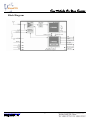
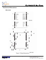
Key Modules For Your Success ANTARIS 4 SuperSense GPS Module MG-LE4S User’s Manual Ver 1.02 www.modulestek.com 展得國際有限公司 Key Modules For Your Success Introduction T 1. Overview Modulestek GPS module MG-LE4S is a high sensitivity ultra low power consumption cost efficient, compact size; plug & play GPS module board designed for a broad spectrum of OEM system applications. This product is based on the ANTARISTM4 supersense technology and it will track up to 16 satellites at a time while providing fast time-to-first-fix. Its far reaching capability meets the sensitivity & accuracy requirements of car navigation as well as other location-based applications, such as AVL system. Handheld navigator, PDAs, Wrist Watches, Personal Locators, Toll collection, Fleet Management, pocket PC, or any battery operated navigation system. The MG-LE4S design utilizes the latest surface mount technology and high level circuit integration to achieve superior performance while minimizing dimension and power consumption. This hardware capability combined with software intelligence makes the board easy to be integrated and used in all kinds of navigation applications or products. The module communicates with application system via TTL level with NMEA0183 protocol. Main Feature 16 channel ANTARIS4 positioning engine Ultra high sensitivity to -158 dBm Supports DGPS, WAAS, EGNOS and MSAS Supports Power saving modes Support 1 USB and 1 USART ports Cost-optimized architecture (No Flash EPROM) Configurable serial I/O baud/sentences setting (GPSMODE pins) Antenna short/open circuit detection and protection Ultra low power consumption 39mA 5 µA backup current Small form factor 22.4 x 17.0 mm with SMT pads (micro package) RoHS compliant (lead-free) www.modulestek.com 展得國際有限公司 2 Key Modules For Your Success Block Diagram www.modulestek.com 展得國際有限公司 3 Key Modules For Your Success Technical Specifications 1. Electrical Characteristics 2. Environmental Charateristics 3. Antenna www.modulestek.com 展得國際有限公司 4 Key Modules For Your Success Mechanical Dimensions MG-LE4S Figure 1: Board dimensions www.modulestek.com 展得國際有限公司 5 Key Modules For Your Success Pin Define Pin# Name 1 GPSMODE8 I Antenna detection configuration, keep floating 2 GPSMODE9 I Antenna detection configuration, keep floating 3 TxD1 O Serial Port 1, if not used keep floating 4 RxD1 I Serial Port 1, if not used keep floating 5 VDDIO I Pad voltage supply, 3.3V typical 6 VCC I Supply voltage, 3.3V typical 7 GND I Ground 8 VDD18OUT O Internal 1.8V regulator output, if not used keep floating 9 GPSMODE10 I Antenna detection configuration, keep floating 10 RESET_N I Reset Pin, active low, if not used keep floating 11 V_BAT I 1.5V~ 3.6V Input for backup RTC&SRAM 12 NC 13~15 Type Description Not Connected, keep floating GND I Ground 16 RF_IN I GPS signal input 17 GND I Ground 18 VCC_RF O Output Voltage RF section 19 V_ANT I Antenna Bias voltage 20 AADET_N I Active Antenna Detect (see application circuit) 21 GPSMODE3 I Sensitivity mode configuration, keep floating 22 GPSMODE2 I Sensitivity mode configuration, keep floating 23 GPSMODE7 I USB Power Mode configuration, keep floating (Default is self-powered) (“0” is bus-powered) 24 VDD_USB I USB Supply, 3.3V typical 25 USB_DM I/O USB data 26 USB_DP I/O USB data 27 EXTINT0 I External Interrupt Pin 28 TIMEPULSE O Time pulse (1 PPS) www.modulestek.com 展得國際有限公司 6 Key Modules For Your Success www.modulestek.com 展得國際有限公司 7 Key Modules For Your Success 1. GGA data set GGA--- Global Positioning System Fixed Data Table 2 contains the values for the following example: $GPGGA,161229.487,3723.2475,N,12158.3416,W,1,07,1.0,9.0,M, , , ,0000*18<CR> <LF> Name Example Units Message ID $GPGGA GGA protocol header UTC Position 161229.487 hhmmss.sss Latitude 3723.2475 ddmm.mmmm N/S Indicator N N=north or S=south Longitude 12158.3416 dddmm.mmmm E/W Indicator W E=east or W=west Position Fix Indicator 1 Description 0 = invalid 1 = GPS fix (SPS) 2 = DGPS fix 3 = PPS fix 4 = Real Time Kinematic 5 = Float RTK 6 = estimated (dead reckoning) 7 = Manual input mode 8 = Simulation mode Satellites Used 07 Range 0 to 12 HDOP 1.0 Horizontal Dilution of Precision MSL Altitude 9.0 meters Units M meters Geoid Separation Units meters M Age of Diff. Corr. meters second Diff. Ref. Station ID 0000 Checksum *18 <CR> <LF> www.modulestek.com 展得國際有限公司 Null fields when DGPS is not used End of message termination 8 Key Modules For Your Success 2. GLL data set GLL--- Geographic Position – Latitude/Longitude Table 4 contains the values for the following example: $GPGLL,3723.2475,N,12158.3416,W,161229.487,A*2C<CR> <LF> Name Example Units Description Message ID $GPGLL GLL protocol header Latitude 3723.2475 ddmm.mmmm N/S Indicator N N=north or S=south Longitude 12158.3416 dddmm.mmmm E/W Indicator W E=east or W=west UTC Position 161229.487 hhmmss.sss Status A A=data valid or V=data not valid Checksum *2C <CR> <LF> www.modulestek.com 展得國際有限公司 End of message termination 9 Key Modules For Your Success 3. GSA data set GSA---GNSS DOP and Active Satellites Table 5 contains the values for the following example: $GPGSA,A,3,07,02,26,27,09,04,15, , , , , ,1.8,1.0,1.5*33<CR> <LF> Name Example Message ID $GPGSA GSA protocol header Mode 1 A M Manual- forced to operate in 2D or 3D mode A Automatic-allowed to automatically switch 2D/3D Mode 2 3 1 Fix not available 2 2D 3 3D Satellite Used in solution 07 Sv on Channel 1 Satellite Used in solution 02 Sv on Channel 2 Satellite Used Units Description Sv on Channel 12 PDOP 1.8 Position Dilution of Precision HDOP 1.0 Horizontal Dilution of Precision VDOP 1.5 Vertical Dilution of Precision Checksum *33 <CR> <LF> www.modulestek.com 展得國際有限公司 End of message termination 10 Key Modules For Your Success 4. GSV data set GSV---GNSS Satellites in View Table 8 contains the values for the following example: $GPGSV,2,1,07,07,79,048,42,02,51,062,43,26,36,256,42,27,27,138,42*71 $GPGSV,2,2,07,09,23,313,42,04,19,159,41,15,12,041,42*41<CR> <LF> Name Example Message ID $GPGSV GSV protocol header Number of Messages1 2 Range 1 to 3 Message Number1 1 Range 1 to 3 Satellites in View 07 Satellite ID 07 Elevation 79 Degrees Azimuth 048 Degrees Channel 1 (Maximum 90) SNR (C/No) 42 DBHz Channel 1 (True, Range 0 to 359) Satellite ID 27 Elevation 27 Degrees Channel 4 (Range 1 to 32) Azimuth 138 Degrees Channel 4 (Maximum 90) SNR (C/No) 42 DBHz Channel 4 (True, Range 0 to 359) Checksum *71 <CR> <LF> Units Description Channel 1 (Range 1 to 32) Range 0 to 99, null when not tracking Range 0 to 99, null when not tracking End of message termination Depending on the number of satellites tracked multiple messages of GSV data may be required. www.modulestek.com 展得國際有限公司 11 Key Modules For Your Success 5. RMC data set RMC---Recommended Minimum Specific GNSS Data Table 9 contains the values for the following example: $GPRMC,161229.487,A,3723.2475,N,12158.3416,W,0.13,309.62,120598, ,*10<CR> <LF> Name Example Message ID $GPRMC RMC protocol header UTC Position 161229.487 hhmmss.sss Status A A=data valid or V=data not valid Latitude 3723.2475 ddmm.mmmm N/S Indicator N N=north or S=south Longitude 12158.3416 dddmm.mmmm E/W Indicator W E=east or W=west Speed Over Ground 0.13 knots Course Over Ground 309.62 degrees Date 120598 Magnetic Variation Checksum Units Description True ddmmyy degrees E=east or W=west (Not shown) *10 <CR> <LF> www.modulestek.com 展得國際有限公司 End of message termination 12 Key Modules For Your Success 6. VTG data set VTG---Course Over Ground and Ground Speed Table 10 contains the values for the following example: $GPVTG,309.62,T, ,M,0.13,N,0.2,K*6E<CR> <LF> Name Example Message ID $GPVTG Course 309.62 Reference T Course M Speed 0.13 Units N Speed 0.2 Units K Checksum *6E www.modulestek.com 展得國際有限公司 Description VTG protocol header degrees Measured heading True degrees Reference <CR> <LF> Units Measured heading Magnetic knots Measured horizontal speed Knots km/hr Measured horizontal speed Kilometer per hour End of message termination 13 Key Modules For Your Success 1. ZDA data set ZDA---Contains information on UTC time, the data and local time An example of a ZDA data set: $GPZDA,130305.2,20,06,2001,00,00,*57<CR> <LF> Name Example Message ID $GPZDA ZDA protocol header UTC 130305.2 UTC Time: 13h 03min 05.2sec Day 20 Day(00 … 31) Month 06 Month(1 … 12) Year 2001 Year Local Zone hour 00 Reserved for data on local time(h) Local Zone mimutes 00 Reserved for data on local time(min) Checksum *57 Checksum <CR> <LF> www.modulestek.com 展得國際有限公司 Units Description End of message termination 14