1
John Blodgett
Urban Information Center
University of Missouri
St. Louis, Mo.
63121
A PROGRAMMER FRIENDLY APPROACH TO GEOCODING
ABSTRACT.
Geocoding - the process of linking data files
containing street addresses to a master street reference file - is a
problem
which
has
been
"solved*'
with
the
Census
Bureau's
DIME/ADMATCH
(or UNIMATCH) system.
However, the value of these
extremely
useful
tools
is
diminished
somewhat because
of
the
complexity of the programming involved in applying them.
There are
perils involved in creating your reference ("nickel") file using
DIME and ADMATCH/PREP.
Mistakes are easy to make and hard to find.
More serious are the problems involved in applying the system to a
wide variety of files in a timely, ef f i cient and reliable manner.
The system developed by the UMSL Urban Information Center provides a
programmer familiar with the general workings of ADMATCH a set of
powerful software tools that can greatly simplify the complex and
error - prone data management aspects of using ADMATCH. These tools
are provided in the form of SAS £r) preprocessor macros, and are
written with total flexibility and ease of use (by a programmer
familiar with the SAS language) in mind. Because they are in source
code
format and because
they
rely heavily on easily
modified
"default" parameter values, they can very easily be customized to
fit the needs of a wide variety of users.
INTRODUCTION
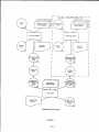
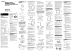
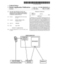
Figure 1 is a reproduction of the ADMATCH system flowchart as
it appears in the ADMATCH User's Manual.
While it may be a useful
depiction of the basic steps involved in geocoding with ADMATCH, i t
is a very partial depiction of most real life applications of the
software.
It does not show, for example, any program or subsystem
that does anything about preprocessor rejects or nonmatched address
records.
They are simply written to a file and/or listed in an
exception report.
What happens to them next is beyond the scope of
the ADMATCH software.
But in terms of a practical geocoding system,
an
efficient
and
relatively
easy-to-use
subsystem
for
fixing
rejected and nonmatched records is critical for many if not most
applications.
The flowchart also omits the "post-processing" phase (this is
covered in a separate manual for some reason) in which the various
matched, nonmatched and rejected records are all brought back into
- 171 -
ADMATCH SYSTEM
FIGURE 1
- 172 -
one or more final output files.
In the portion of the flowchart
dealing with preprocessing the "reference file" (presumably a DIME
file or its equivalent) there is no indication of the need for a
special preprocessor step to split the 2-sided "DIME" records into
single-sided "nickel" records prior to preprocessing. There is also
no indication that more than one system sort may be required in order
to produce multiple versions of the reference file for matching or
different criteria (e.g. one version for matching on ZIP, another
for matching on state and place.)
Our purpose here is not to be critical of the ADMATCH system or
its authors.
We
think the basic ADMATCH program modules, the
preprocessor and the matcher are two of the most clever, useful and
reliable software products ever written.
However we feel that as a
software system for dealing with the entire complex problem of
geocoding
- especially
in
an
environment
requiring a lot of
flexibility
as
well
as
computer
resource
economy
and
where
programmer
time is at a premium - ADMATCH simply does not do
enough.
What we would like to do in this paper is to discuss an
approach to geocoding that retains the valuable program modules from
ADMATCH, but incorporates
them
into a more complete
geocoding
system.
The system we have developed has been very much customized
to fit the needs of our own environment, and may not be totally
appropriate for another shop (many shops could undoubtedly do with
something a lot simpler.)
What we would really like to emphasize
here is not the specifics of our system, but rather the underlying
approach or philosophy behind it.
DESIGNING THE GEOCODING SYSTEM:
ASSUMPTIONS AND REQUIREMENTS
In designing a "complete" geocoding system (or any other system
for that matter) it is a good idea to start with a list of features
and capabilities that you would like your system to have.
The
following list describes the major functions we wanted our system
to be able to perform, and includes some specific guidelines on how
we wanted these capabilities implemented.
The list reflects our
assumptions
and rather subjective evaluations
("filling out the
preprocessor control card is tedious and error-prone").
It is based
on several years experience running ADMATCH software without a
structured set of software modules to complete the system.
1.
The process of filling out the PREP (ADMATCH preprocessor)
control card
is tedious and error-prone.
The errors are
usually not detected (you pointed to the wrong column but PREP
didn't know the difference), and often result in complete runs
which are a waste of time and computer resources.
Control
cards used in other modules, especially SAVE cards in the
- 173 -
matcher module, are fraught with similar perils.
too much column-counting going on.
2.
A system for displaying unmatched addresses
for updating of these rejects is required.
There is far
and
providing
3.
An ADMATCH project creates too many datasets and requires
far too much coding of error-prone JCL statements.
Our system
should standardize as many files as possible so that the DD
statements can be stored as part of a JCL procedure, and never
have to be coded by the user. A more systematic way of dealing
with all the permanent datasets is required.
4.
As a record passes through the geocoding process it can
appear
on many
different
files:
the original
input, the
preprocessed file, the sorted preprocessed file, the initial
match run reject file, the sorted match run reject file, the
updated match run reject file, the preprocessed (again) updated
match run reject file, etc., etc.
It is not uncommon for these
records to be several hundred characters long, and for the
files to contain thousands, tens of thousands and occasionally
even hundreds of thousands of records.
Since ADMATCH looks at
only a small part of each record in order to standardize and
match it, this information should be stripped off and only
these relatively small records should ever be processed by any
but the first and last geocoding system modules.
This should
result in significant savings in storage and processing costs.
5.
It can be very expensive to pass a relatively small address
file (of say, a few thousand records) against our full 200,000
+ - record reference file (the St. Louis SMSA preprocessed
"Nickel" file.)
It would be a significant improvement if we
could do a "pre-check" of the addresses against a much smaller
disk-resident reference summary file, to see which records can
be matched at the ZIP and/or preprocessed street name level,
and to be able to correct these "won't match" records before
actually doing a match run against the full tape f ile. At the
same time, this would be a good place to use an "alias file" to
substitute for common misspelling or true alias street names.
6. The subsystem for going from the DIME file to a preprocessed
nickel file should be streamlined and made more flexible.
It
would be nice not to have to preprocess every DIME record
twice, i.e. to preprocess the actual DIME record prior to
splitting into 2 block face records.
The subsystem should
allow for creating the compact summary datasets at the ZIP and
PREPNAME levels, and for printing out compact well labeled
reports that can be used to assist in looking up unmatched
records.
- 174 -
7.
Programmers in our shop do almost all their work using
SAS.
It would
therefore
be
extremely beneficial
if our
geocoding
system
could
at
least
begin and end with
SAS
data sets.
This would not only save us from having to write
PUT/INPUT statements but would go a long way towards solving
the data management problems referred to under item 3, above.
8.
Programmers and self-reliant users should be able to set up
and run simple geocoding applications without having to read
the pink and purple ADMATCH manuals.
A SAS-BASED SOLUTION:
WHY AND HOW
We chose the SAS software package as the basis
for our
geocoding
system,
not
because
of
any
of
its
considerable
statistical capabilities, but because of its excellent facilities
for sequential file management and powerful programming language.
When we first began coding the system (around 1979) we were not
particularly
impressed
with
the
capabilities
for
writing
"user-friendly" systems in SAS, but felt that its macro features
would be adequate.
Our first SAS-based
system, written
using
"old style" SAS macros was a major improvement over what we had
been doing, but was not as flexible and easy to use as we would have
liked.
It worked off a lot. of "parameter macros", and you wound up
going in and modifying the actual source code a lot to handle
"special" cases.
The system was then rewritten (or more accurately,
is still in the process of being rewritten) with the introduction of
the much more powerful SAS preprocessor macro language which became
available in late 1982.
URISA
imposes time and space
requirements
that
mercifully
prohibit any detailed description of how the SAS/ADMATCH system works.
But here are some of its more notable features:
1.
The system is driven by a set of "programmer friendly"
macros that allow the user to supply parameter values which are
used by the SAS preprocessor
to
(sometimes
conditionally)
generate the appropriate SAS statements.
2.
The ADMATCH system modules PREP and MTCH (the actual load
modules, unaltered for over 10 years) are invoked from inside
SAS.
In terms of CPU time these two modules still do most of
the work.
- 175 -
3. All files passed to the PREP program are in exactly the same
format.
Each record consists of a 7-digit numeric KEY field, a
33-character ADDRESS field and a 5-character ZIP field.
It
always has the same LRECL and blocking factor. This means that
the error-prone PREP control card becomes a "constant", and
does not have to be prepared anew for each run.
It also means
that the file which is read by PREP (SYS004) can be written by
SAS to a temporary dataset that is a "constant" (JCL-wise) for
all
runs.
Similarly,
the
PREP
output
files
(SYS005 and
SYS006)are "constant" temporaries that can be easily converted
to SAS datasets.
The user normally only needs to code one DD
statement defining his SAS data
library, while the 3 DD
statements for SYS004, SYS005 and SYS006 become "invisible" to
the user because they are coded as part of a standard JCL
procedure.
Similar savings occur in all subsequent phases.
Storing files as SAS datasets makes them more compact and much
easier to sort, list, document, delete, edit, merge, summarize
and generally take-care of.
4.
Preprocessing the reference (DIME) files is handled with a
3-macro subsystem.
The fi rst converts the sequential DIME file
to a SAS dataset; the second preprocesses the file and stores
the result as a SAS NICKEL dataset; and the final macro sorts
and writes a specific sequential nickel file.
(The second
module has options to generate reference SAS datasets of all
ZIPs and ZIP/PREPNAME combinations.)
5.
It is still possible to get 37% match
areas, but you get
such nice
concise
depicting your failures.
rates in high growth
informative
reports
6.
This system is rarely used to do the same thing twice.
Yet, we can usually give 48-hour
turnaround
(assuming no
reject lookups) with almost total reliability that the geocodes
v .11 be where you wanted them on your output file or dataset
(converting final results back to sequential files instead of
SAS datasets is not a problem.)
7.
Programmers can be taught how to use the system in a day or
two.
They do not need to know all the details of the PREP and
MTCH program logic, although it is important that at least one
person in the shop be knowledgeable in these areas.
8.
Many geocoding applications have as their final goal the
linking of aggregated
geocoded files with census data for
market penetration
reports.
For example, after you attach
tracts to the student data base you want to get a report
showing
both
total
students
per
tract and perhaps
total
students per tract per capita. It is also common to then
- 176 -
want to display this information in a computer drawn map.
All
of this type of postprocessing is made relatively simple with
SAS and SAS/GRAPH.
9.
We have not done any careful benchmarking or conducted any
experiments to see how geocoding with our SAS/ADMATCH system
compares to how we were doing with PL1 and IBM utilities. But
our guess is that this system requires about a fifth of the
programmer
effort,
about
half
of
the
computer
resources
(CPU time, tape and disk I/O, permanent data storage), and is
several times more likely to do the job right the first time.
Overall turnaround time has improved dramatically.
CONCLUSIONS
Geocoding
is a tough problem.
Even with excellent public
domain softwa re products like ADMATCH available, most shops are
justifiably
reluctant
to
get
into
this
specialized
kind
of
processing.
You have to be willing to invest a certain amount of
time in learning about the specifics of how a geocoding system
works.
You also are going to run into problems with very poor match
rates in certain areas unless you are willing to take on the task of
keeping your reference file up to date.
And, finally, unless you
have some very fixed requirements for what kinds of files you will
be geocoding and just how you want to handle them, you should expect
to spend a fair amount of time in developing auxiliary software to
handle the very considerable housekeeping tasks involved in managing
all the data sets you* 11 be creating.
If you are in an environment
where
computer
resource costs are a significant
consideration,
geocoding large files can get very expensive.
This has resulted in
a lot fewer shops actually doing in-house geocoding. They are either
sending it out to a service bureau, doing it by hand, or getting by
with ZIP data.
This is an unfortunate waste of some good software
and some very expensive DIME files.
While we certainly don* t think our specific software is any
universal cure for the under-geocoding phenomenon, we do think that
the general approach we have taken has certainly solved a good part
of the problem in our shop.
This approach can be characterized as
follows:
1.
Avoid starting over.
Somebody has probably already solved
all or part of the problem.
Don' t waste good solutions just
because they're not perfect.
2.
Find a good general-purpose data management tool and build
your solutions around it.
SAS is an excellent tool for such
- 177 -
things; IBM JCL and IBM utilities are not.
3.
Avoid building solutions that cannot be easily modified to
handle
all
the
special
cases
you 1 11
never
be
able
to
anticipate.
Avoid constants where parameters will fit nicely.
But make the parameters easy to specify, with lots of defaults.
4.
Instead of end-user friendly solutions, build programmer
friendly solutions, that programmers can easily customize into
user-friendly ones.
5.
Use preprocessors or meta-languages to build your system.
Then
you
can
enjoy
lots
of
flexibility
with
lots
of
parameterization, with almost no sacrifice in efficiency.
6. Spend most of your time worrying about exactly what you want
your system to do, then find someone who can tell the computer
exactly how to do it.
7.
If you decide to write a paper describing your system,
don't wait until two days before the manuscript is due to give
it. to your secretary.
If you do, they will not be programmer
friendly.
ACKNOWLEDGEMENTS
SAS is
Carolina.
a
registered
trademark
- 178 -
of
SAS
Institute,
Cary,
North