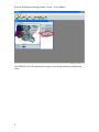
1
Western Washington Hydrology Model
Version 3.0
User Manual
August 2006
Western Washington Hydrology Model
Version 3.0
User Manual
Prepared by
Clear Creek Solutions, Inc.
August 2006
To download the Western Washington Hydrology Model
and the electronic version of this user’s manual,
please visit our website at:
http://www.ecy.wa.gov/programs/wq/stormwater/wwhm_training/wwhm/wwhm_v3/index.html.
If you have questions about the WWHM, please contact:
Foroozan Labib, Environmental Engineer
Department of Ecology
Water Quality Program
(360) 407-6439
[email protected]
If you require this document in an alternative format, please call the secretary at (360)
407-6401. The TTY number is 711 or 1-800-833-6388.
Table of Contents
Introduction…………………………………………………………………..
Quick Start……………………………………………………………………
Main Screens…………………………………………………………………
Map Information Screen………………………………………………………
General Project Information Screen……………………………………………
Schematic Editor………………………………………………………………
Basin……………………………………………………………………………
Lateral Basin……………………………………………………………………
Lateral I Basin…………………………………………………………………
Trapezoidal Pond………………………………………………………………
Vault……………………………………………………………………………
Tank……………………………………………………………………………
Irregular Pond…………………………………………………………………
Gravel Trench Bed……………………………………………………………
Sand Filter……………………………………………………………………
Riser/Weir……………………………………………………………………
Infiltration………………………………………………………………………
AutoPond………………………………………………………………………
Stage-Storage-Discharge Table…………………………………………………
High Groundwater/Wetland……………………………………………………
Channel…………………………………………………………………………
Flow Splitter……………………………………………………………………
Time Series………………………………………………………………………
SSD Table………………………………………………………………………
Point of Compliance……………………………………………………………
Connecting Elements……………………………………………………………
Analysis Screen…………………………………………………………………
Reports Screen…………………………………………………………………
Tools Screen……………………………………………………………………
LID Analysis Screen……………………………………………………………
Options……………………………………………………………………..……
1
3
24
25
26
27
28
31
32
33
35
36
37
40
41
42
44
45
47
48
50
51
53
55
57
59
62
70
71
73
77
Appendix A: Default WWHM3 HSPF Pervious Parameter Values…………….
Appendix B: Default WWHM3 HSPF Impervious Parameter Values………….
80
89
Western Washington Hydrology Model Version 3.0 User Manual
INTRODUCTION
The WWHM3 is the third edition of the Western Washington Hydrology Model. It was
designed by the Washington State Department of Ecology, AQUA TERRA Consultants,
and Clear Creek Solutions, Inc. (the successor to the Washington offices of AQUA
TERRA Consultants). This version is faster, more flexible, easier, and offers more
options than WWHM2. Because of its increased flexibility the user can now model
almost any hydrologic condition related to stormwater control and design.
This user manual and development of WWHM3 was funded by the Washington State
Department of Ecology Contract No. C0500104 with AQUA TERRA Consultants.
AQUA TERRA staff (and now Clear Creek Solutions staff) responsible for the WWHM3
and this user manual are Joe Brascher, Shanon White, and Doug Beyerlein.
Purpose
The purpose of the WWHM3 is to size stormwater control facilities to mitigate the effects
of increased runoff (peak discharge, duration, and volume) from proposed land use
changes that impact natural streams, wetlands, and other water courses.
The WWHM3 provides:
• A uniform methodology for the 19 counties of Western Washington
• A more accurate methodology than single event design storms
• An easy-to-use software package
The WWHM3 is based on:
• Continuous simulation hydrology (HSPF)
• Actual long-term recorded precipitation data
• Measured pan evaporation data
• Historic vegetation (for Predeveloped conditions)
• Regional HSPF parameters
Parameter values can be modified for local conditions.
What’s New in Version 3
WWHM3 gives the user greater modeling flexibility and options. Version 2 was limited
to drainages of less than half a square mile (320 acres) because of the lack of a
conveyance feature (natural channel or pipe). This limitation does not apply to
WWHM3; with Version 3 the user can model entire watersheds of unlimited size as long
as they are contained within a single county.
Specific changes and additions in Version 3 include:
• Icons are now called elements in the Schematic screen.
• There are separate elements for trapezoidal ponds, irregular ponds, tanks, and
vaults.
1
Western Washington Hydrology Model Version 3.0 User Manual
•
•
•
•
•
•
•
•
•
•
•
•
Basin land use categories now include land slopes (flat, moderate, and steep).
Runoff credits have been replace with specific categories to disperse roof runoff
to lawn, etc.
Standard residential has been removed, although the user can still explicitly input
the standard residential assumptions.
Two lateral basins (pervious and impervious) have been added. Flow can go
directly from a lateral basin to another basin without a connecting conveyance
system.
A flow splitter now offers greater flexibility in deciding how to separate the flow.
The open channel conveyance element has been added.
Gravel trench beds have been added.
Wetponds have been added. Wetponds can be used to model wetlands and areas
influenced by high groundwater.
There is no longer a Point of Compliance icon (or element). The user can specify
a point of compliance at any element by right clicking on that element and
selecting “Point of Compliance”. There can be multiple points of compliance.
The model keeps track of each one.
There is no longer an Extender icon (or element). The user now explicitly links
one element to another.
Preferences has been replaced by View, Options and a criteria checker has been
added.
View/Export Time Series has been moved into Tools and additional options have
been added.
Computer Requirements
• Windows 2000/XP with 150 MB uncompressed hard drive space
• Internet access (only required for downloading WWHM3, not required for
executing WWHM3)
• Pentium 3 or faster processor (desirable)
• Color monitor (desirable)
Before Starting the Program
• Knowledge of the site location and/or street address.
• Knowledge of the actual distribution of existing site soil by category (A/B, C, or
saturated).
• Knowledge of the planned distribution of the proposed development (buildings,
streets, sidewalks, parking, lawn areas) overlying the soil categories.
• An idea of a first approximation of the top surface area for a trapezoidal or
irregular-shape pond (if used).
2
Western Washington Hydrology Model Version 3.0 User Manual
QUICK START
Below is a brief set of steps that show how to use the WWHM3 to quickly size a
stormwater detention pond.
1. Select the county in which the project site is located.
Click the down arrow in the box in the upper left corner. A list of all 19 Western
Washington counties is shown. Scroll down to find the county you want. Left click on
the county name. The county map will then show on the map screen.
Locate the project site on the map. Use the map controls to magnify a portion of the map,
if needed. Select the project site by left clicking on the map location. A red square will
be placed on the map identifying the project site.
3
Western Washington Hydrology Model Version 3.0 User Manual
The WWHM3 selects the appropriate rain gage record and precipitation multiplication
factor.
4
Western Washington Hydrology Model Version 3.0 User Manual
2. Use the tool bar (immediately above the map) to move to the
Scenario Editor. Click on the General Project Information button.
The General Project Information button will bring up the Schematic
Editor.
The schematic editor screen contains two
scenarios: Predeveloped and Mitigated.
Set up first the Predeveloped scenario and
then the Mitigated scenario.
Check the Predeveloped scenario box.
Left click on the Basin element under the
Elements heading. The Basin element is the
upper left element.
Select any grid cell (preferably near the top of
the grid) and left click on that grid. The basin
will appear in that grid cell.
The entire grid can be moved up, down, left,
or right using the Move Elements arrow buttons.
The gird coordinates from one project can be saved (Save x,y) and used for new projects
(Load x,y).
5
Western Washington Hydrology Model Version 3.0 User Manual
To the right of the grid is the land use information associated with the basin. Select the
appropriate soil, vegetation, and land slope for the Predeveloped scenario. For this
example we will assume that the Predeveloped land use is 10 acres of C soil (till) with
forest vegetation, on a flat (0-5%) slope.
6
Western Washington Hydrology Model Version 3.0 User Manual
The exit from this basin will be selected as our point of compliance for the Predeveloped
scenario. Right click on the basin element and highlight Connect to Point of Compliance.
The Point of Compliance screen will be shown for
Predeveloped Basin 1. The POC (Point of Compliance)
outlet has been checked for both surface runoff and
interflow. These are the two flow components of
stormwater runoff. Do not check the groundwater box
unless there is observed and documented base flow on
the project site.
Click the Connect button in the low right corner to connect this point of compliance to
the Predeveloped basin.
7
Western Washington Hydrology Model Version 3.0 User Manual
After the point of compliance has been added to the basin the basin element will change.
A small box with a bar chart graphic will be shown in the lower right corner of the basin
element. This small POC box identifies this basin as a point of compliance.
8
Western Washington Hydrology Model Version 3.0 User Manual
3. Set up the Mitigated scenario.
First, check the Mitigated scenario box and place a basin element on the grid.
9
Western Washington Hydrology Model Version 3.0 User Manual
For the Mitigated land use we have:
5 acres of C, lawn, flat
2 acres of roads, flat
1 acre of roof tops
1 acre of driveways, flat
1 acre of sidewalks, flat
We will add a trapezoidal pond downstream of the basin.
10
Western Washington Hydrology Model Version 3.0 User Manual
The trapezoidal pond element is placed below the basin element on the grid. Right click
on the basin and select Connect To Element. A green line will appear with one end
connected to the basin. With the mouse pointer pull the other end of the line down to the
trapezoidal pond and click on the
pond. This will bring up the
From Basin to Conveyance
screen. As with the
Predeveloped scenario we want
to only connect the surface flow
and the interflow from the basin
to the pond. Click OK.
11
Western Washington Hydrology Model Version 3.0 User Manual
A line will connect the basin to the pond.
12
Western Washington Hydrology Model Version 3.0 User Manual
Right click on the trapezoidal pond element to connect the pond’s outlet to the point of
compliance. Highlight Connect to Point Of Compliance and click.
13
Western Washington Hydrology Model Version 3.0 User Manual
The Point of Compliance screen will be shown for the pond. The pond has one outlet (by
default). The outflow from the pond will be compared with the Predeveloped runoff.
The point of compliance is designated as POC 1 (WWHM3 allows for multiple points of
compliance). Click on the Connect button.
14
Western Washington Hydrology Model Version 3.0 User Manual
The point of compliance is shown on the pond element as a small box with the letter “A”
and a bar chart symbol in the lower right corner.
15
Western Washington Hydrology Model Version 3.0 User Manual
4. Sizing the pond.
A trapezoidal stormwater pond can be sized either manually or automatically (using
AutoPond). For this example AutoPond will be used.
Click on the AutoPond button and the AutoPond screen will appear. The user can set the
pond depth (default: 7 feet), pond length to width ratio (default: 1 to 1), pond side slopes
(default: 3 to 1), and the outlet structure configuration (default: 1 orifice and riser with
rectangular notch weir).
16
Western Washington Hydrology Model Version 3.0 User Manual
To optimize the pond design and create the smallest pond possible, move the Automatic
Pond Adjuster pointer from the left to the right.
The pond does not yet have any dimensions. Click the Create Pond button to create
initial pond dimensions and optimize the pond size and outlet structure.
The WWHM3 first computes the Predeveloped runoff then the flow frequency for the
Predeveloped runoff. From the flow frequency results half of the 2-year and the 50-year
flows are identified. This is the range selected for the flow duration analysis. The
17
Western Washington Hydrology Model Version 3.0 User Manual
Predeveloped flow duration values between half of the 2-year and the 50-year are plotted
on the screen in blue.
The WWHM3 computes Mitigated runoff. AutoPond selects initial pond and outlet
structure dimensions and the Mitigated flow is routed through the pond. The outflow
from the pond is analyzed and the Mitigated flow duration is plotted on the screen in red.
AutoPond compares the Mitigated flow duration results with the Predeveloped flow
duration values. If the Mitigated flow duration values are greater than the Predeveloped
values AutoPond increases the size of the pond or alters the outlet structure based on
predefined rules and reruns the Mitigated runoff through the revised pond. If the
Mitigated flow duration values are less than the Predeveloped values AutoPond decreases
the size of the pond or alters the outlet structure and reruns the Mitigated runoff through
the revised pond. Either way, AutoPond continues this exercise until the smallest
possible pond is designed. At that point AutoPond announces that it is finished. The
pond is now sized.
The user may continue to manually optimize the pond by manually changing pond
dimensions and/or the outlet structure configuration. After making these changes the
user should click on the Optimize Pond button to check the results and see if AutoPond
can make further improvements.
18
Western Washington Hydrology Model Version 3.0 User Manual
The final pond dimensions (bottom length, bottom width, effective pond depth, and side
slopes) and outlet structure information (riser height, riser diameter, riser weir type, weir
notch height and width, and orifice diameter and height) are shown on the trapezoidal
pond screen to the right of the Schematic grid.
19
Western Washington Hydrology Model Version 3.0 User Manual
5. Review analysis.
The Analysis tool bar button (third from the left) brings up the Analysis screen where the
user can look at the results. Each time series dataset is listed in the Analyze Datasets box
in the lower left corner. To review the flow duration analysis at the point of compliance
select the POC 1 tab at the bottom and make sure that both the 501 POC 1 Predeveloped
flow and 801 POC 1 Developed flow are highlighted. Click the Run Analysis button.
20
Western Washington Hydrology Model Version 3.0 User Manual
The flow duration plot for both Predeveloped and Mitigated flows will be shown along
with the specific flow values and number of times Predeveloped and Mitigated flows
exceeded those flow values. The Pass/Fail on the right indicates whether or not at that
flow level the Ecology flow control standard criteria were met and the pond passes at that
flow level (from half of the 2-year flow to the 50-year). If not, a Fail is shown; one Fail
fails the pond design.
21
Western Washington Hydrology Model Version 3.0 User Manual
6. Produce report.
Click on the Reports tool bar button (fourth from the left) to generate a project report
with all of the project information and results. Scroll down the Report screen to see all of
the results.
22
Western Washington Hydrology Model Version 3.0 User Manual
7. Save project.
To save the project click on File in the upper left corner and select Save As.
Select a file name and save
the WWHM3 project file.
The user can exit WWHM3
and later reload the project
file with all of its
information by going to
File, Open.
23
Western Washington Hydrology Model Version 3.0 User Manual
MAIN SCREENS
WWHM3 has six main screens. These main screens can be accessed through the buttons
shown on the tool bar above or via the View menu.
The six main screens are:
•
•
•
•
•
•
Map Information
General Project Information
Analysis
Reports
Tools
LID (Low Impact Development) Analysis
Each is discussed in more detail in the following sections.
24
Western Washington Hydrology Model Version 3.0 User Manual
MAP INFORMATION SCREEN
The Map Screen contains county information. The map is directly linked to the
meteorological database that contains precipitation and evaporation data. The
precipitation gage and precip factor are shown to the right of the map. They change
depending on the project site location.
The user can elect to use Washington State Department of Transportation (DOT)
precipitation data developed by MGS Consulting by checking the “Use DOT data” box to
the right of the map. When the DOT data box is checked the map screen changes to
show a map of the entire 19 counties of Western Washington with the area for which the
DOT precipitation data are available outlined (the data are not available everywhere).
The county selection can be changed by clicking on the pulldown menu above the map
and selecting one of the 19 Western Washington counties.
The user can provide site information (optional).
The user locates the project site on the map screen by using the mouse and left clicking at
the project site location. Right clicking on the map re-centers the view. The + and –
buttons zoom in and out, respectively. The cross hair button zooms out to the full county
view. The arrow keys scroll the map view.
25
Western Washington Hydrology Model Version 3.0 User Manual
GENERAL PROJECT INFORMATION SCREEN
The project screen contains all of the information about the project site for the two land
use scenarios: Predeveloped land use conditions and the Mitigated (developed) land use
conditions. To change from one scenario to another check the box in front of the
scenario name in the upper left corner of the screen.
Predeveloped is defined as the existing conditions prior to land use development. Runoff
from the Predeveloped scenario is used as the target for the Mitigated scenario
compliance. Unless there are special circumstances, the Department of Ecology requires
that Predeveloped land use be Forest. However, the model will accept any land use for
this scenario.
Mitigated is defined as the developed land use with mitigation measures (as selected by
the user). Mitigated is used for sizing stormwater control and water quality facilities.
The runoff from the Mitigated scenario is compared with the Predeveloped scenario
runoff to determine compliance with Ecology standards.
Below the scenario boxes are the Elements (formerly called ‘icons’ in WWHM2). Each
element represents a specific feature (basin, pond, etc.) and is described in more detail in
the following section.
26
Western Washington Hydrology Model Version 3.0 User Manual
SCHEMATIC EDITOR
The project screen also contains the Schematic Editor. The Schematic Editor is the grid
to the right of the elements. This grid is where each element is placed and linked
together. The grid, using the scroll bars on the left and bottom, expands as large as
needed to contain all of the elements for the project.
All movement on the grid must be from the top of the grid down.
The space to the right of the grid will contain the appropriate element information.
To select and place an element on the grid, first left click on the specific element in the
Elements menu and then left click on the selected grid square. The selected element will
appear in the grid square. (DO NOT drag and drop the element, like in WWHM2.)
The entire grid can be moved up, down, left, or right using the Move Elements arrow
buttons.
The gird coordinates from one project can be saved (Save x,y) and used for new projects
(Load x,y).
27
Western Washington Hydrology Model Version 3.0 User Manual
BASIN
The Basin element represents a drainage area that can have any combination of soils,
vegetation, and land uses. A basin produces three types of runoff: (1) surface runoff, (2)
interflow, and (3) groundwater. The user can specify where each of these three types of
runoff should be directed. The default setting is for the surface runoff and interflow to go
to the stormwater facility; groundwater should not be connected unless there is observed
base flow occurring in the drainage basin.
The user inputs the number of acres of appropriate basin land use information. Pervious
land use information is in the form of soil, vegetation, and land slope. For example, “C,
Forest, Flat” means SCS soil type C (till), forest vegetation, and flat (0-5%) land slope.
There are three basic soil types: A/B (outwash soils), C (till), and SAT (saturated/
wetland/hydric soils).
There are three basic vegetation categories: forest (second growth Douglas Fir), pasture
(non-forested natural areas/scrub/shrub rural vegetation), and lawn (sod lawn/grass/
landscaped urban vegetation).
There are also three land slope categories: flat (0-5%), moderate (5-15%), and steep
(>15%).
28
Western Washington Hydrology Model Version 3.0 User Manual
Impervious areas are divided into five types with three different slopes. The four types
are: roads, roofs, driveways, sidewalks, and parking. The slope categories are the same
as for the pervious land use (flat, moderate, steep). Pond area is also listed as an
impervious area.
Runoff credits are included in the nine pervious land categories at the bottom of the
Available Pervious list (see below).
These eight land uses are:
(1) C/IMP DISP/FLAT = Dispersal of impervious area runoff on C soil with flat slope.
(2) C/IMP DISP/MOD = Dispersal of impervious area runoff on C soil with moderate
slope.
(3) C/IMP DISP/STEEP = Dispersal of impervious area runoff on C soil with steep
slope.
(4) A/B/IMP INF/FLAT = Infiltration of impervious area runoff on A/B soil with flat
slope.
(5) A/B/IMP INF/MOD = Infiltration of impervious area runoff on A/B soil with
moderate slope.
(6) A/B/IMP INF/STEEP = Infiltration of impervious area runoff on A/B soil with steep
slope.
(7) SAT/IMP DISP/FLAT = Dispersal of impervious area runoff on saturated soil with
flat slope.
29
Western Washington Hydrology Model Version 3.0 User Manual
(8) SAT/IMP DISP/MOD = Dispersal of impervious area runoff on saturated soil with
moderate slope.
(9) SAT/IMP DISP/STEEP = Dispersal of impervious area runoff on saturated soil with
steep slope.
The standard residential option (WWHM2) is not explicitly included in WWHM3. The
user can still use the standard residential default values by manually computing and
adding the appropriate areas to the basin land use information. The standard residential
default values are:
• 3200 square feet (0.073 acres) of roof per residential lot
• 1000 square feet (0.023 acres) of driveway per residential lot
• the remainder of the residential lot is considered to be lawn.
30
Western Washington Hydrology Model Version 3.0 User Manual
LATERAL BASIN (Pervious)
The pervious lateral basin is similar to the standard basin except that the runoff from the
lateral basin goes to another adjacent lateral basin (impervious or pervious) rather than
directly to a conveyance system or stormwater facility. By definition, the pervious lateral
basin contains only a single pervious land type. Impervious area is handled separately
with the impervious lateral basin (Lateral I Basin).
The user selects the pervious lateral basin land type by checking the appropriate box on
the Available Soil Types Tools screen. This information is automatically placed in the
Soil (PERLND) Type box above. Once entered, the land type can be changed by clicking
on the Change button on the right.
The user enters the number of acres represented by the lateral basin land type.
If the lateral basin contains two or more pervious land use types then the user should
create a separate lateral basin for each.
31
Western Washington Hydrology Model Version 3.0 User Manual
LATERAL I BASIN (Impervious)
The impervious lateral basin is similar to the standard basin except that the surface runoff
from the lateral impervious basin goes to another adjacent lateral basin (impervious or
pervious) rather than directly to a conveyance system or stormwater facility. By
definition, the impervious lateral basin contains only impervious land types. Pervious
area is handled separately with the pervious lateral basin (Lateral Basin).
The user selects the impervious lateral basin land type by checking the appropriate box
on the Available Impervious Coverages screen. This information is automatically placed
in the Impervious (IMPLND) Type box above. Once entered, the land type can be
changed by clicking on the Change button on the right.
The user enters the number of acres represented by the lateral impervious basin land type.
If the lateral impervious basin contains two or more impervious land use types then the
user should create a separate lateral I basin for each.
32
Western Washington Hydrology Model Version 3.0 User Manual
TRAPEZOIDAL POND
In WWHM3 there is an individual pond element for each type of pond and stormwater
control facility. The pond element shown above is for a trapezoidal pond. This is the
most common type of stormwater pond.
A trapezoidal pond has dimensions (bottom length and width, depth, and side slopes) and
an outlet structure consisting of a riser and one or more orifices to control the release of
stormwater from the pond. A trapezoidal pond includes the option to infiltrate runoff, if
the soils are appropriate and there is sufficient depth to the underlying groundwater table.
The user has the option to specify that different outlets be directed to different
downstream destinations, although usually all of the outlets go to a single downstream
location.
AutoPond will automatically size a trapezoidal pond to meet Ecology flow control
standards. QuickPond will instantly create a pond without checking it for compliancy
with Ecology standards.
The user can change the default name “Trapezoidal Pond 1” to another more appropriate
name, if desired.
33
Western Washington Hydrology Model Version 3.0 User Manual
Precipitation and evaporation can be applied to the pond. The default standard setting is
not to apply precipitation and evaporation, but to treat the pond surface area as an
impervious surface.
The pond bottom elevation can be set to an elevation other than zero if the user wants to
actual elevations. All pond stage values are relative to the bottom elevation. Negative
bottom elevations are not allowed.
The pond effective depth is the pond height (including freeboard) above the pond bottom.
It is not the actual elevation of the top of the pond.
Pond side slopes are in terms of horizontal distance over vertical. A standard 3:1 (H/V)
side slope would be given a value of 3. A vertical side slope has a value of 0.
The pond bottom is assumed to be flat.
The pond outlet structure consists of a riser and zero to three orifices. The riser has a
height (typically one foot less than the effective depth) and a diameter. The riser can
have either a flat top or a weir notch cut into the side of the top of the riser. The notch
can be either rectangular, V-shaped, or a Sutro weir. More information on the riser weir
shapes and orifices is provided later in this manual.
After the pond is given dimensions and outlet information the user can view the resulting
stage-storage-discharge table by clicking on the “Open Table” arrow in the lower right
corner of the pond information screen. This table hydraulically defines the pond’s
characteristics.
34
Western Washington Hydrology Model Version 3.0 User Manual
VAULT
The storage vault has all of the same characteristics of the trapezoidal pond, except that
the user does not specify the side slopes (by definition they are zero).
AutoVault and QuickVault work the same way as AutoPond and QuickPond.
35
Western Washington Hydrology Model Version 3.0 User Manual
TANK
A storage tank is a cylinder placed on its side. The user specifies the tank’s diameter and
length.
There is no AutoTank (automatic tank sizing routine). The user must manually size the
tank to meet Ecology’s standards. There is a QuickTank option that creates a tank, but
does not check for compliance with Ecology’s standards.
36
Western Washington Hydrology Model Version 3.0 User Manual
IRREGULAR POND
An irregular pond is any pond with a shape that differs from the rectangular top of a
trapezoidal pond. An irregular pond has all of the same characteristics of a trapezoidal
pond, but its shape must be defined by the user.
To create the shape of an irregular pond the user clicks on the “Open PondPad” button.
This allows the user to access the PondPad interface (see below).
37
Western Washington Hydrology Model Version 3.0 User Manual
PondPad Interface
The PondPad interface is a grid on which the user can specify the outline of the top of the
pond and the pond’s side slopes.
The user selects the line button (second from the top on the upper left corner of the
PondPad screen). Once the line button is turned on the user moves the mouse over the
grid to locate the pond’s corner points. The user does this in a clockwise direction to
outline the pond’s top perimeter. The user can select individual points by clicking on the
point button immediately below the line button. Once selected, any individual point can
be moved or repositioned.
38
Western Washington Hydrology Model Version 3.0 User Manual
The default side slope value is 3 (3:1). The side slopes can be individually changed by
right clicking on the specific side (which changes the line color from black to red) and
then entering the individual side slope value in the slope text box.
The grid scale can be changed by entering a new value in the grid scale box. The default
value is 200 feet.
PondPad Controls and Numbers
Clear:
Line:
Point:
The Clear button clears all of the lines on the grid.
The Line button allows the user to draw new lines with the mouse.
The Point button allows the user to move individual points to alter the
pond shape and size.
Sq Ft:
Grid Scale:
Grid X:
Converts the computed pond area from square feet to acres and back.
Changes the length of a grid line. Default grid scale is 200 feet.
Horizontal location of the mouse pointer on the grid
(0 is the upper left corner).
Vertical location of the mouse pointer on the grid
(0 is the upper left corner)
Grid Y:
Area:
Slope:
Top area of the pond (either in square feet or acres).
Side slope of the selected line (side of the pond).
39
Western Washington Hydrology Model Version 3.0 User Manual
GRAVEL TRENCH BED
The gravel trench bed is a new feature in WWHM3. It is used to spread and infiltrate
runoff, but also can have one or more surface outlets represented by an outlet structure
with a riser and multiple orifices.
The user specifies the trench length, bottom width, total depth, bottom slope, and left and
right side slopes.
The material layers represent the amended soils and their design characteristics (thickness
and porosity). These are the soil layers added to the gravel trench bed to filter the runoff
prior to dispersal.
QuickTrench will instantly create a gravel trench bed with default values without
checking it for compliancy with Ecology standards.
40
Western Washington Hydrology Model Version 3.0 User Manual
SAND FILTER
The sand filter is a water quality facility. It does not infiltrate runoff, but is used to filter
runoff through a medium and sent it downstream. It can also have one or more surface
outlets represented by an outlet structure with a riser and multiple orifices.
The user must specify the facility dimensions (bottom length and width, effective depth,
and side slopes. The hydraulic conductivity of the sand filter and the filter material depth
are also needed to size the sand filter (default values are 1.0 and 1.5, respectively). The
goal of the sand filter is meet the Ecology treatment standard of filtering at least 91% of
the total runoff volume.
The filter discharge is calculated using the equation Q = K*I*A, where Q is the discharge
in cubic feet per second (cfs). K equals the hydraulic conductivity (inches per hour). For
sand filters K = 1.0 in/hr. Sand is the default medium. If another filtration material is
used then the design engineer should enter the appropriate K value supported by
documentation and approval by the reviewing authority.
Design of a sand filter requires input of facility dimensions and outlet structure
characteristics, running the sand filter scenario, and then checking the volume
calculations to see if the Percent Filtered equals or exceeds 91.0%. If the value is less
than 91% then the user should increase the size of the sand filter dimensions and/or
change the outlet structure.
41
Western Washington Hydrology Model Version 3.0 User Manual
RISER/WEIR
The trapezoidal pond, vault, tank, irregular pond, gravel trench bed, and sand filter all use
a riser for the outlet structure to control discharge from the facility.
The riser is a vertical pipe with a height
above pond bottom (typically one foot
less than the effective depth). The user
specifies the riser height and diameter.
The riser can have up to three round
orifices. The bottom orifice is usually
located at the bottom of the pond and/or
above any dead storage in the facility.
The user can set the diameter and height
of each orifice. The model will
automatically calculate the maximum
orifice discharge value, QMax (cfs), if
the pond dimensions have already been
defined.
The user specifies the riser type as either flat or notched. The weir notch can be either
rectangular, V-notch, or a Sutro weir. The shape of each type of weir is shown below.
Rectangular Notch
V-Notch
Sutro
By selecting the appropriate notch type the user is then given the option to enter the
appropriate notch type dimensions.
Riser and orifice equations used in WWHM3 are provided below.
42
Western Washington Hydrology Model Version 3.0 User Manual
Headr = the water height over the notch/orifice bottom.
q = discharge
Riser Head Discharge:
Head = water level above riser
q = 9.739 * Riser Diameter * Head ^ 1.5
Orifice Equation:
q = 3.782 * (Orifice Diameter) ^ 2 * SQRT(Headr)
Rectangular Notch:
b = NotchWidth *- (1- 0.2 * Headr)
where b >= 0.8
q = 3.33 * b * Headr ^ 1.5
Sutro:
Wh = Top Width + {(Bottom Width- Top Width)/Notch Height }* Headr
Wd = Bottom Width - Wh (the difference between the bottom and top widths)
Q1 = (rectangular notch q where Notch Width = Wh)
Q2 = (rectangular notch q where Notch Width = Wd)
q = Q1 + Q2 / 2
V-Notch:
Notch Bottom = height from bottom of riser to bottom of notch
Theta = Notch Angle
a = 2.664261 - 0.0018641 * Theta + 0.00005761 * Theta ^2
b = -0.48875 + 0.003843 * Theta - 0.000092124 * Theta ^2
c = 0.3392 - 0.0024318 * Theta + 0.00004715 * Theta ^2
YoverH = Headr / (NotchBottom + Headr)
Coef = a + b * Headr + c * Headr ^2
q = (Coef * Tan(Theta / 2)) * (Headr ^ (5 / 2))
43
Western Washington Hydrology Model Version 3.0 User Manual
INFILTRATION
Infiltration of stormwater runoff is
a recommended solution if certain
conditions are met. These
conditions include: a soils report,
testing, groundwater protection,
pre-settling, and appropriate
construction techniques (see
Ecology’s Stormwater
Management Manual for Western
Washington for details).
The user clicks on the Infiltration
option arrow to change infiltration
from NO to YES. This activates
the infiltration input options:
measured infiltration rate,
infiltration reduction factor, and
whether or not to allow infiltration
through the wetted side
slopes/walls.
The infiltration reduction factor is a multiplier for the measured infiltration rate and
should be less than one. It is the same as the inverse of a safety factor. For example, a
safety factor of 2 is equal to a reduction factor of 0.5.
Infiltration occurs only through the bottom of the facility if the wetted surface area option
is turned off. Otherwise the entire wetted surface area is used for infiltration.
After the model is run and flow is routed through the infiltration facility the total volume
infiltrated, total volume through the riser, total volume through the facility, and percent
infiltrated are reported on the screen. If the percent infiltrated is 100% then there is no
surface discharge from the facility. The percent infiltrated can be less than 100% as long
as the surface discharge does not exceed Ecology’s flow control standards.
44
Western Washington Hydrology Model Version 3.0 User Manual
AUTOPOND
AutoPond automatically creates a pond size and designs the outlet structure to meet
Ecology’s flow duration criteria. The user can either create a pond from scratch or
optimize an existing pond design.
AutoPond requires that the Predeveloped and Mitigated basins be defined prior to using
AutoPond. Clicking on the AutoPond button brings up the AutoPond window and the
associated AutoPond controls.
AutoPond controls:
Automatic Pond Adjuster: The slider at the top of the AutoPond window allows the user
to decide how thoroughly the pond will be designed for efficiency. The lowest setting (01 min) at the left constructs an initial pond with checking it for Ecology’s flow duration
criteria. The second setting to the right creates and sizes a pond to pass Ecology’s flow
duration criteria; however, the pond is not necessarily optimized. The higher settings
increase the amount of optimization. The highest setting (farthest left) will size the most
efficient (smallest) pond, but will result in longer computational time.
Pond Depth: Pond depth is the total depth of the pond and should include at least one
foot of freeboard (above the riser). The pond’s original depth will be used when
45
Western Washington Hydrology Model Version 3.0 User Manual
optimizing an existing pond; changing the value in the Pond Depth text box will override
any previous set depth value. The default depth is 7 feet.
Pond Length to Width Ratio: This bottom length to width ratio will be maintained
regardless of the pond size or orientation. The default ratio value is 1.0
Pond Side Slopes: AutoPond assumes that all of the pond’s sides have the same side
slope. The side slope is defined as the horizontal distance divided by the vertical. A
typical side slope is 3 (3 feet horizontal to every 1 foot vertical). The default side slope
value is 3.
Choose Outlet Structure: The user has the choice of either 1 orifice and rectangular notch
or 3 orifices. If the user wants to select another outlet structure option then the pond must
be manually sized.
Create Pond: This button creates a pond when the user does not input any pond
dimensions or outlet structure information. Any previously input pond information will
be deleted.
Optimize Pond: This button optimizes an existing pond. It cannot be used if the user has
not already created a pond.
Accept Pond: This button will stop the AutoPond routine at the last pond size and
discharge characteristics that produce a pond that passes Ecology’s flow duration criteria.
AutoPond will not stop immediately if the flow duration criteria has not yet been met.
The bottom length and width and volume at riser head will be computed by AutoPond;
they cannot be input by the user.
AutoVault operates the same way as AutoPond.
There are some situations where AutoPond (or AutoVault) will not work. These
situations occur when complex routing conditions upstream of the pond make it difficult
or impossible for AutoPond to determine which land use will be contributing runoff to
the pond. For these situations the pond will have to be manually sized.
46
Western Washington Hydrology Model Version 3.0 User Manual
STAGE-STORAGE-DISCHARGE TABLE
The stage-storage-discharge table hydraulically represents any facility that requires
stormwater routing. The table is automatically generated by WWHM3 when the user
inputs storage facility dimensions and outlet structure information. The WWHM3
generates 100 lines of stage, surface area, storage, surface discharge, and infiltration
values starting at a stage value of zero (facility bottom height) and increasing in equal
increments to the maximum stage value (facility effective depth).
When the user or WWHM3 changes a facility dimension (for example, bottom length) or
an orifice diameter or height the model immediately recalculates the stage-storagedischarge table.
The user can input to WWHM3 a stage-storage-discharge table created elsewhere. A
separate element, SSD Table, is required. See the SSD Table description below for more
information on how to load such a table to the WWHM3 program.
47
Western Washington Hydrology Model Version 3.0 User Manual
HIGH GROUNDWATER/WETLAND
The High Groundwater/Wetland element is a complex element that should only be used
in special applications by advanced WWHM3 users. The purpose of the high
groundwater/wetland element is to model hydrologic conditions where high groundwater
rises to the surface (or near the surface) and reduces the ability of water to infiltrate into
the soil.
The element can be used to represent wetland conditions with surface ponding where the
discharge from the wetland is via a surface release. The user is given the choice of using
either a natural channel, berm/weir, or control structure to determine the release
characteristics.
The element provides default values for some of the parameters, especially as they relate
to high groundwater. The user should be fully familiar with these parameters and the
appropriate values for their site prior to attempting to use this element. The high
groundwater parameter definitions are shown below.
Cohension water porosity: soil pore space in micropores.
Gravitational water porosity: soil pore space in macropores in the lower and groundwater
layers of the soil column.
48
Western Washington Hydrology Model Version 3.0 User Manual
Upper gravitation water porosity: soil pore space in macropores in the upper layer of the
soil column.
Upper zone storage factor: portion of the water stored in macropores in the upper soil layer
which will not surface discharge, but will percolate, evaporate or transpire.
Lower zone storage factor: portion of the water stored in micropores in the lower soil layer
which will not gravity drain, but will evaporate or transpire.
Additional documentation is available in “WWHM3 Description of HSPF High
Groundwater Parameters” available from the Washington State Department of Ecology.
49
Western Washington Hydrology Model Version 3.0 User Manual
CHANNEL
The Channel element is a new feature in WWHM3. Channel allows the user to route
runoff from a basin or facility through an open channel to a downstream destination.
The channel cross section is represented by a trapezoid and is used with Manning’s
equation to calculate discharge from the channel. If a trapezoid does not accurately
represent the cross section then the user should represent the channel with an
independently calculated SSD Table element or use the Use X-Sections option.
The user inputs channel bottom width, channel length, channel bottom slope, channel left
and right side slopes, maximum channel depth, and the channel’s roughness coefficient
(Manning’s n value). The user can select channel type and associated Manning’s n from
a table list directly above the Channel Dimension information or directly input the
channel’s Manning’s n value.
The channel is used to represent a natural or artificial open channel through which water
is routed. It can be used to connect a basin to a pond or a pond to a pond or multiple
channels can linked together.
50
Western Washington Hydrology Model Version 3.0 User Manual
FLOW SPLITTER
The flow splitter divides the runoff and sends it to two difference destinations. The
splitter has a primary exit (exit 1) and a secondary exit (exit 2). The user defines how the
flow is split between these two exits.
The user can define a flow control structure with a riser and one to three orifices for each
exit. The flow control structure works the same way as the pond outlet structure, with the
user setting the riser height and diameter, the riser weir type (flat, rectangular notch, Vnotch, or Sutro), and the orifice diameter and height.
51
Western Washington Hydrology Model Version 3.0 User Manual
The second option is that the flow split can be based on a flow threshold. The user sets
the flow threshold value (cfs) for exit 1 at which flows in excess of the threshold go to
exit 2. For example, if the flow threshold is set to 5 cfs then all flows less than or equal
to 5 cfs go to exit 1. Exit 2 gets only the excess flow above the 5 cfs threshold (total flow
minus exit 1 flow).
52
Western Washington Hydrology Model Version 3.0 User Manual
TIME SERIES
The WWHM3 uses time series of precipitation, evaporation, and runoff stored in its
database (HSPF WDM file). The user has the option to create or use a time series file
external from the WWHM3 in the WWHM3. This may be a time series of flow values
created by another HSPF model. An example is offsite runoff entering a project site. If
this offsite runoff is in an existing WDM file and is the same period as the WWHM3 data
and the same simulation time step (hourly) then it can be linked to the WWHM3 model
using the Time Series element.
To link the external time series to the WWHM3 the user clicks on the Load WDM button
and identifies the external WDM file. The external WDM’s individual time series files
are shown in the box immediately below the Load WDM button and under the box
heading “Choose Input Dataset”. The selected input dataset is the time series that will be
used by the WWHM3.
The user also has the option of modifying and/or copying time series files using the
options shown in the Functions box. These options are: add, subtract, apply factor
(multiply), copy, raise to a power, select a threshold greater than, and select a threshold
less than. Once a specific option is selected then by clicking on Run Analysis the time
series is appropriately modified.
53
Western Washington Hydrology Model Version 3.0 User Manual
The user can also output a time series generated by the WWHM3 using the options
shown in the Time Series Out box. The user chooses the appropriate WDM file
(WWHM3 can have a maximum of five separate WDM files, but usually has just one)
and the time series (output dataset) within the WDM file. This output time series can be
saved and later used as an input time series in other WWHM3 models, if appropriate.
54
Western Washington Hydrology Model Version 3.0 User Manual
SSD TABLE
The SSD Table is a stage-storage-discharge table externally produced by the user and is
identical in format to the stage-storage-discharge tables generated internally by the
WWHM3 for ponds, vaults, tanks, and channels.
The easiest way to create a SSD Table outside of the WWHM3 is to use a spreadsheet
with a separate column for stage, surface area, storage, and discharge (in that order).
Save the spreadsheet file as a space or comma-delimited file. A text file can also be
created, if more convenient.
The SSD Table must use the following units:
Stage: feet
Surface Area: acres
Storage: acre-feet
Discharge: cubic feet per second (cfs)
A fifth column can be used to create a second discharge (cfs). This second discharge can
be infiltration or a second surface discharge.
Certain rules apply to the SSD Table whether it is created inside or outside of the
WWHM3. These rules are:
55
Western Washington Hydrology Model Version 3.0 User Manual
1. Stage (feet) must start at zero and increase with each row. The incremental
increase does not have to be consistent.
2. Storage (acre-feet) must start at zero and increase with each row. Storage values
should be physically based on the corresponding depth and surface area, but the
WWHM3 does not check externally generated storage values.
3. Discharge (cfs) must start at zero. Discharge does not have to increase with each
row. It can stay constant or even decrease. Discharge cannot be negative.
Discharge should be based on the outlet structure’s physical dimensions and
characteristics, but the WWHM3 does not check externally generated discharge
values.
4. Surface area (acres) is only used if precipitation to and evaporation from the
facility are applied.
To input an externally generated SSD Table, first create and save the table outside of the
WWHM3. Use the Browse button to locate and load the file into the WWHM3.
56
Western Washington Hydrology Model Version 3.0 User Manual
POINT OF COMPLIANCE
WWHM3 allows for multiple points of compliance (maximum of 99) in a single project.
A point of compliance is defined as the location at which the Predeveloped and Mitigated
flows will analyzed for compliance with Ecology’s flow control standard.
WWHM2 had a point of compliance icon or element; WWHM3 does not.
The point of compliance is selected by right clicking on the element at which the
compliance analysis will be made. In the example above, the point of compliance
analysis will be conducted at the outlet of the trapezoidal pond.
57
Western Washington Hydrology Model Version 3.0 User Manual
Once the point of compliance has been selected
the element is modified on the Schematic screen
to include a small box with the letter “A” (for
Analysis) in the lower right corner. This
identifies the outlet from this element as a point
of compliance.
58
Western Washington Hydrology Model Version 3.0 User Manual
CONNECTING ELEMENTS
Elements are connected by right clicking on the upstream element (in this example Basin
1) and selecting and then left clicking on the Connect To Element option. By doing so
the WWHM3 extends a line from the upstream element to wherever the user wants to
connect that element.
59
Western Washington Hydrology Model Version 3.0 User Manual
The user extends the connection line to the downstream element (in this example, a pond)
and left clicks on the destination element. This action brings up the From Basin to
Conveyance box that allows the user to specify which runoff components to route to the
downstream element.
Stormwater runoff is defined as
surface flow + interflow. Both
boxes should be checked.
Groundwater should not be
checked for the standard land
development mitigation analysis.
Groundwater should only be
checked when there is observed
and documented base flow
occurring from the upstream
basin.
After the appropriate boxes have
been checked click the OK button.
60
Western Washington Hydrology Model Version 3.0 User Manual
The final screen will look like the above screen. The basin information screen on the
right will show that Basin 1 surface and interflow flows to Trapezoidal Pond 1
(groundwater is not connected).
61
Western Washington Hydrology Model Version 3.0 User Manual
ANALYSIS SCREEN
The Analysis tool bar button (third from the left) brings up the Analysis screen where the
user can look at the results. The Analysis screen allows the user to analyze and compare
flow durations, flow frequency, water quality, hydrographs, and wetland fluctuations.
62
Western Washington Hydrology Model Version 3.0 User Manual
The user can analyze all time series datasets or just flow, stage, precipitation,
evaporation, or point of compliance (POC) flows by selecting the appropriate tab below
the list of the different datasets available for analysis.
63
Western Washington Hydrology Model Version 3.0 User Manual
Flow Duration
Flow duration at the point of compliance (POC 1) is the most common analysis. A plot
of the flow duration values is shown on the left, the flow values on the right.
64
Western Washington Hydrology Model Version 3.0 User Manual
Flow Frequency
Flow frequency plots are shown on the left and the 2-, 5-, 10-, 25-, 50-, and 100-year
frequency values are on the right. Flow frequency calculations are based on a Log
Pearson Type III distribution of yearly peak flow values.
65
Western Washington Hydrology Model Version 3.0 User Manual
Water Quality
The water quality screen allows the user to compute the target volumes and flows for
offline and online water quality facilities. Select the dataset 801 POC 1 Mitigated flow
for the water quality analysis. Click on the Gear button on the left side of the Water
Quality analysis results for the WWHM3 to compute volumes and flows based on
Ecology’s water quality facility sizing criterion (91% of total runoff volume) or a
criterion selected by the user via View, Options, Scaling Factor Water Quality.
An online water quality facility is downstream of the project flow control facility; all of
the runoff is routed through an online facility. An offline facility receives only a portion
of the total runoff.
66
Western Washington Hydrology Model Version 3.0 User Manual
Hydrographs
The user can graph/plot any or all time series data by selecting the Hydrograph tab. The
Create Graph screen is shown and the user can select the time series to plot, the time
interval (yearly, monthly, daily, or hourly), and type of data (peaks, average, or volume).
The selected time series are shown. To graph the selected time series the user clicks on
the Graph button.
67
Western Washington Hydrology Model Version 3.0 User Manual
The hydrograph shows the yearly maximum/peak flow values for each time series for the
entire simulation period (in this example, from 1949 through 1999).
The graph can be either saved or printed.
68
Western Washington Hydrology Model Version 3.0 User Manual
Wetland Fluctuation
This option is still under construction pending selection of appropriate wetland
fluctuation criteria by Washington State Department of Ecology wetland specialists.
69
Western Washington Hydrology Model Version 3.0 User Manual
REPORTS SCREEN
The Reports tool bar button (fourth from the left) brings up the Report screen where the
user can look at all of the project input and output. The project report can be saved or
printed.
70
Western Washington Hydrology Model Version 3.0 User Manual
TOOLS SCREEN
The Tools screen is accessed with the Tools tool bar (second from the right). The two
purposes of the Tools screen are:
(1) To allow users to import HSPF PERLND from existing HSPF UCI files and/or view
and edit WWHM3 PERLND parameter values.
(2) To allow users to export time series datasets.
To export a time series dataset click on the Export Dataset box.
71
Western Washington Hydrology Model Version 3.0 User Manual
The list of available time series datasets will be shown. The user can select the start and
end dates for the data they want to export.
The time step (hourly, daily, monthly, yearly) can also be specified. If the user wants
daily, monthly, or yearly data the user is given the choice of either selecting the
maximum, minimum, or the sum of the hourly values.
Click the Export button.
The user provides a file name and
the format or type of file. The file
type can be ASCII, comma
delimited, Excel spreadsheet, or
Access database.
Click Save to save the exported time
series file.
72
Western Washington Hydrology Model Version 3.0 User Manual
LID ANALYSIS SCREEN
The LID tool bar button (farthest on the right) brings up the Low Impact Development
Scenario Generator screen.
The LID scenario generator can be used to compare the amount of runoff from different
land types and combinations. The user can quickly see how changing the land use affects
surface runoff, interflow, groundwater, and evapotranspiration.
73
Western Washington Hydrology Model Version 3.0 User Manual
The easiest way to compare different land use scenarios is to place all of them on the
same Schematic Editor screen grid. Each basin can then represent a different land use
scenario. Because the LID scenario generator only compares runoff volume there is no
need to do any routing through a conveyance system or stormwater facility.
For this example the three basins are assigned the following land uses:
Basin 1: 100 acres C, Forest, Flat
Basin 2: 100 acres C, Lawn, Flat
Basin 3: 50 acres C, Lawn, Flat; 50 acres Parking Flat
Each basin is assigned a different POC (point of compliance) for the LID analysis.
74
Western Washington Hydrology Model Version 3.0 User Manual
Click on the Compute LID Base Data button to generate the LID analysis data and
summarize the surface runoff, interflow, groundwater, precipitation, evaporation, and
total runoff for all of the basins. The results will be shown for each basin in terms of its
POC.
For the pervious portion of Basin 1 (50 acres of C, Lawn, Flat) the distribution of the
precipitation is:
Surface runoff = 3.024 inches per year
Interflow = 21.171 inches per year
Groundwater = 10.910 inches per year
Evaporation = 15.375 inches per year
To look at the other basins click on the Select POC To arrow and select the basin of
interest.
The LID analysis results can be presented in terms of either inches per year or acre-feet
per year by checking the appropriate box in the lower right portion of the LID analysis
screen.
To compare the different scenarios side-by-side in a graphical format click on the Display
Water Balance Chart.
75
Western Washington Hydrology Model Version 3.0 User Manual
The water balance chart graphically displays the runoff distribution for all three land use
scenarios side-by-side.
The bottom red is the surface runoff. Above in yellow is interflow; then green for
groundwater and blue for evaporation. Basin 1 (Scenario 1) is all forest and produces the
least amount of surface runoff and interflow (the sum of surface and interflow is the total
stormwater runoff). Basin 2 is all lawn; it produces more surface runoff and interflow
than Basin 1. Basin 3 is 50% lawn and 50% impervious and produces the largest amount
of surface runoff and interflow and the smallest amount of groundwater and evaporation.
A maximum of seven scenarios can be graphed at one time.
76
Western Washington Hydrology Model Version 3.0 User Manual
OPTIONS
Options can be accessed by going to View, Options. This will bring up the Options
screen and the ability to modify the duration standards, water quality scaling factors, and
the criteria checker.
Duration Criteria
The Washington State Department of Ecology’s flow control standard is based on flow
duration. The duration criteria are:
1. If the post-development flow duration values exceed any of the predevelopment
flow levels between 50% and 100% of the two-year predevelopment peak flow
values (100 Percent Threshold) then the flow control standard requirement has not
been met.
2. If the post-development flow duration values exceed any of the predevelopment
flow levels between 100% of the two-year and 100% of the 50-year
predevelopment peak flow values more than 10 percent of the time (110 Percent
Threshold) then the flow control standard has not been met.
3. If more than 50 percent of the flow duration levels exceed the 100 percent
threshold then the flow control standard has not been met.
77
Western Washington Hydrology Model Version 3.0 User Manual
The duration criteria in the WWHM3 can be modified by the user if appropriate and the
permitting and reviewing agency allows.
The user can conduct the duration analysis using either (1) durations based on
Predeveloped flow frequency, or (2) durations based on user defined flow values.
If using durations based on Predeveloped flow frequency the percent of the lower limit
can be changed from the default of the 2-year flow event to a higher or lower percent
value. The lower and upper flow frequency limits (2-year and 50-year) also can be
changed.
If using durations based on user defined flow values click on that option and input the
lower and upper flow values.
The default pass/fail threshold is 110%. This value can be changed by the user.
The duration standards can be changed for a single point of compliance. Click on the
Update button once all of the changes have been made. To return to the default values
click on the Restore Defaults button.
Any change(s) to the default duration standards must be approved by the reviewing and
permitting agencies.
78
Western Washington Hydrology Model Version 3.0 User Manual
Scaling Factors_Water Quality
The user can change the scaling factors for precipitation (minimum and maximum) and
pan evaporation. Neither should be changed without agency approval.
The water quality volume percentage is set to 91% of the total runoff volume. If allowed,
this percent value can be changed by the user.
Click on the Update button once all of the changes have been made. To return to the
default values click on the Restore Defaults button.
79
Western Washington Hydrology Model Version 3.0 User Manual
APPENDIX A: DEFAULT WWHM3 HSPF PERVIOUS PARAMETER VALUES
The default WWHM3 HSPF pervious parameter values are found in the WWHM3 file
defaultpers.uci.
The default WWHM3 HSPF pervious parameter values are based on the USGS report:
Dinicola, R.S. 1990. Characterization and Simulation of Rainfall-Runoff Relations for
Headwater Basins in Western King and Snohomish Counties, Washington. WaterResources Investigations Report 89-4052. U.S. Geological Survey. Tacoma, WA.
For some parameters the default WWHM3 HSPF pervious parameter values have been
modified from the values listed in the USGS report. These modifications are based on
the professional judgment and experience of Clear Creek Solutions staff in modeling
Western Washington watersheds with HSPF.
HSPF parameter documentation is found in the document:
Bicknell, B.R., J.C. Imhoff, J.L. Kittle Jr, T.H. Jobes, and A.S. Donigian Jr. 2001.
Hydrological Simulation Program – Fortran, User’s Manual for Version 12. AQUA
TERRA Consultants. Mountain View, CA.
80
Western Washington Hydrology Model Version 3.0 User Manual
Table 1. WWHM3 Pervious Land Types
PERLND
No.
1
2
3
4
5
6
7
8
9
10
11
12
13
14
15
16
17
18
19
20
21
22
23
24
25
26
27
28
29
30
31
32
33
34
35
36
Soil
Vegetation/Surface
Slope
A/B
A/B
A/B
A/B
A/B
A/B
A/B
A/B
A/B
C
C
C
C
C
C
C
C
C
Saturated
Saturated
Saturated
Saturated
Saturated
Saturated
Saturated
Saturated
Saturated
C
C
C
A/B
A/B
A/B
Saturated
Saturated
Saturated
Forest
Forest
Forest
Pasture
Pasture
Pasture
Lawn
Lawn
Lawn
Forest
Forest
Forest
Pasture
Pasture
Pasture
Lawn
Lawn
Lawn
Forest
Forest
Forest
Pasture
Pasture
Pasture
Lawn
Lawn
Lawn
Impervious dispersed on Lawn
Impervious dispersed on Lawn
Impervious dispersed on Lawn
Impervious infiltrated on Lawn
Impervious infiltrated on Lawn
Impervious infiltrated on Lawn
Impervious dispersed on Lawn
Impervious dispersed on Lawn
Impervious dispersed on Lawn
Flat
Moderate
Steep
Flat
Moderate
Steep
Flat
Moderate
Steep
Flat
Moderate
Steep
Flat
Moderate
Steep
Flat
Moderate
Steep
Flat
Moderate
Steep
Flat
Moderate
Steep
Flat
Moderate
Steep
Flat
Moderate
Steep
Flat
Moderate
Steep
Flat
Moderate
Steep
81
Western Washington Hydrology Model Version 3.0 User Manual
Table 2. WWHM3 HSPF Pervious Parameter Values – Part I
PERLND
No.
LZSN
INFILT
LSUR
1
2
3
4
5
6
7
8
9
10
11
12
13
14
15
16
17
18
19
20
21
22
23
24
25
26
27
28
29
30
31
32
33
34
35
36
5.0
5.0
5.0
5.0
5.0
5.0
5.0
5.0
5.0
4.5
4.5
4.5
4.5
4.5
4.5
4.5
4.5
4.5
4.0
4.0
4.0
4.0
4.0
4.0
4.0
4.0
4.0
4.5
4.5
4.5
5.0
5.0
5.0
4.0
4.0
4.0
2.00
2.00
2.00
1.50
1.50
1.50
0.80
0.80
0.80
0.08
0.08
0.08
0.06
0.06
0.06
0.03
0.03
0.03
2.00
2.00
2.00
1.80
1.80
1.80
1.00
1.00
1.00
0.03
0.03
0.03
0.80
0.80
0.80
1.00
1.00
1.00
400
400
400
400
400
400
400
400
400
400
400
400
400
400
400
400
400
400
100
100
100
100
100
100
100
100
100
400
400
400
400
400
400
100
100
100
SLSUR KVARY AGWRC
0.050
0.100
0.150
0.050
0.100
0.150
0.050
0.100
0.150
0.050
0.100
0.150
0.050
0.100
0.150
0.050
0.100
0.150
0.001
0.010
0.100
0.001
0.010
0.100
0.001
0.010
0.100
0.050
0.100
0.150
0.050
0.100
0.150
0.001
0.010
0.100
0.3
0.3
0.3
0.3
0.3
0.3
0.3
0.3
0.3
0.5
0.5
0.5
0.5
0.5
0.5
0.5
0.5
0.5
0.5
0.5
0.5
0.5
0.5
0.5
0.5
0.5
0.5
0.5
0.5
0.5
0.3
0.3
0.3
0.5
0.5
0.5
LZSN: Lower Zone Storage Nominal (inches)
INFILT: Infiltration (inches per hour)
LSUR: Length of surface flow path (feet)
SLSUR: Slope of surface flow path (feet/feet)
KVARY: Variable groundwater recession
AGWRC: Active Groundwater Recession Constant (per day)
82
0.996
0.996
0.996
0.996
0.996
0.996
0.996
0.996
0.996
0.996
0.996
0.996
0.996
0.996
0.996
0.996
0.996
0.996
0.996
0.996
0.996
0.996
0.996
0.996
0.996
0.996
0.996
0.996
0.996
0.996
0.996
0.996
0.996
0.996
0.996
0.996
Western Washington Hydrology Model Version 3.0 User Manual
Table 3. WWHM3 HSPF Pervious Parameter Values – Part II
PERLND
No.
INFEXP
INFILD
1
2
3
4
5
6
7
8
9
10
11
12
13
14
15
16
17
18
19
20
21
22
23
24
25
26
27
28
29
30
31
32
33
34
35
36
2
2
2
2
2
2
2
2
2
2
2
2
2
2
2
2
2
2
10
10
10
10
10
10
10
10
10
2
2
2
2
2
2
10
10
10
2
2
2
2
2
2
2
2
2
2
2
2
2
2
2
2
2
2
2
2
2
2
2
2
2
2
2
2
2
2
2
2
2
2
2
2
DEEPFR BASETP AGWETP
0
0
0
0
0
0
0
0
0
0
0
0
0
0
0
0
0
0
0
0
0
0
0
0
0
0
0
0
0
0
0
0
0
0
0
0
0
0
0
0
0
0
0
0
0
0
0
0
0
0
0
0
0
0
0
0
0
0
0
0
0
0
0
0
0
0
0
0
0
0
0
0
0.00
0.00
0.00
0.00
0.00
0.00
0.00
0.00
0.00
0.00
0.00
0.00
0.00
0.00
0.00
0.00
0.00
0.00
0.70
0.70
0.70
0.50
0.50
0.50
0.35
0.35
0.35
0.00
0.00
0.00
0.00
0.00
0.00
0.35
0.35
0.35
INFEXP: Infiltration Exponent
INFILD: Infiltration ratio (maximum to mean)
DEEPFR: Fraction of groundwater to deep aquifer or inactive storage
BASETP: Base flow (from groundwater) Evapotranspiration fraction
AGWETP: Active Groundwater Evapotranspiration fraction
83
Western Washington Hydrology Model Version 3.0 User Manual
Table 4. WWHM3 HSPF Pervious Parameter Values – Part III
PERLND
No.
CEPSC
1
2
3
4
5
6
7
8
9
10
11
12
13
14
15
16
17
18
19
20
21
22
23
24
25
26
27
28
29
30
31
32
33
34
35
36
0.20
0.20
0.20
0.15
0.15
0.15
0.10
0.10
0.10
0.20
0.20
0.20
0.15
0.15
0.15
0.10
0.10
0.10
0.20
0.20
0.20
0.15
0.15
0.15
0.10
0.10
0.10
0.10
0.10
0.10
0.10
0.10
0.10
0.10
0.10
0.10
UZSN
NSUR
INTFW
IRC
LZETP
0.50
0.50
0.50
0.50
0.50
0.50
0.50
0.50
0.50
0.50
0.50
0.30
0.40
0.40
0.25
0.25
0.25
0.15
3.00
3.00
3.00
3.00
3.00
3.00
3.00
3.00
3.00
0.25
0.25
0.15
0.50
0.50
0.50
3.00
3.00
3.00
0.35
0.35
0.35
0.30
0.30
0.30
0.25
0.25
0.25
0.35
0.35
0.35
0.30
0.30
0.30
0.25
0.25
0.25
0.50
0.50
0.50
0.50
0.50
0.50
0.50
0.50
0.50
0.25
0.25
0.25
0.25
0.25
0.25
0.50
0.50
0.50
0
0
0
0
0
0
0
0
0
6
6
6
6
6
6
6
6
6
1
1
1
1
1
1
1
1
1
6
6
6
0
0
0
1
1
1
0.7
0.7
0.7
0.7
0.7
0.7
0.7
0.7
0.7
0.5
0.5
0.3
0.5
0.5
0.3
0.5
0.5
0.3
0.7
0.7
0.7
0.7
0.7
0.7
0.7
0.7
0.7
0.5
0.5
0.3
0.7
0.7
0.7
0.7
0.7
0.7
0.70
0.70
0.70
0.40
0.40
0.40
0.25
0.25
0.25
0.70
0.70
0.70
0.40
0.40
0.40
0.25
0.25
0.25
0.80
0.80
0.80
0.60
0.60
0.60
0.40
0.40
0.40
0.25
0.25
0.25
0.25
0.25
0.25
0.40
0.40
0.40
CEPSC: Interception storage (inches)
UZSN: Upper Zone Storage Nominal (inches)
NSUR: Surface roughness (Manning’s n)
INTFW: Interflow index
IRC: Interflow Recession Constant (per day)
LZETP: Lower Zone Evapotranspiration fraction
84
Western Washington Hydrology Model Version 3.0 User Manual
Table 5. WWHM3 HSPF Pervious Parameter Values – Part IV
PERLND
No.
MELEV
1
2
3
4
5
6
7
8
9
10
11
12
13
14
15
16
17
18
19
20
21
22
23
24
25
26
27
28
29
30
31
32
33
34
35
36
400
400
400
400
400
400
400
400
400
400
400
400
400
400
400
400
400
400
400
400
400
400
400
400
400
400
400
400
400
400
400
400
400
400
400
400
BELV
GWDATM
PCW
PGW
UPGW
0
0
0
0
0
0
0
0
0
0
0
0
0
0
0
0
0
0
0
0
0
0
0
0
0
0
0
0
0
0
0
0
0
0
0
0
0
0
0
0
0
0
0
0
0
0
0
0
0
0
0
0
0
0
0
0
0
0
0
0
0
0
0
0
0
0
0
0
0
0
0
0
0.35
0.35
0.35
0.33
0.33
0.33
0.31
0.31
0.31
0.20
0.20
0.20
0.18
0.18
0.18
0.15
0.15
0.15
0.17
0.17
0.17
0.15
0.15
0.15
0.12
0.12
0.12
0.15
0.15
0.15
0.31
0.31
0.31
0.12
0.12
0.12
0.38
0.38
0.38
0.35
0.35
0.35
0.33
0.33
0.33
0.23
0.23
0.23
0.20
0.20
0.20
0.17
0.17
0.17
0.20
0.20
0.20
0.17
0.17
0.17
0.15
0.15
0.15
0.17
0.17
0.17
0.33
0.33
0.33
0.15
0.15
0.15
0.45
0.45
0.45
0.42
0.42
0.42
0.40
0.40
0.40
0.28
0.28
0.28
0.25
0.25
0.25
0.20
0.20
0.20
0.25
0.25
0.25
0.22
0.22
0.22
0.18
0.18
0.18
0.20
0.20
0.20
0.40
0.40
0.40
0.18
0.18
0.18
MELEV: Mean surface elevation of the land segment (feet)
BELV: Base elevation for active groundwater (feet)
GWDATM: Datum for the groundwater elevation (feet)
PCW: Cohesion Water Porosity (fraction)
PGW: Gravitational Water Porosity (fraction)
UPGW: Upper Gravitational Water porosity (fraction)
A description of these parameters is in Appendix C.
85
Western Washington Hydrology Model Version 3.0 User Manual
Table 6. WWHM3 HSPF Pervious Parameter Values – Part V
PERLND
No.
STABNO
1
2
3
4
5
6
7
8
9
10
11
12
13
14
15
16
17
18
19
20
21
22
23
24
25
26
27
28
29
30
31
32
33
34
35
36
1
1
1
1
1
1
1
1
1
1
1
1
1
1
1
1
1
1
1
1
1
1
1
1
1
1
1
1
1
1
1
1
1
1
1
1
SRRC
SREXP
IFWSC
DELTA
0.1
0.1
0.1
0.1
0.1
0.1
0.1
0.1
0.1
0.1
0.1
0.1
0.1
0.1
0.1
0.1
0.1
0.1
0.1
0.1
0.1
0.1
0.1
0.1
0.1
0.1
0.1
0.1
0.1
0.1
0.1
0.1
0.1
0.1
0.1
0.1
0
0
0
0
0
0
0
0
0
0
0
0
0
0
0
0
0
0
0
0
0
0
0
0
0
0
0
0
0
0
0
0
0
0
0
0
4
4
4
4
4
4
4
4
4
4
4
4
4
4
4
4
4
4
4
4
4
4
4
4
4
4
4
4
4
4
4
4
4
4
4
4
0.2
0.2
0.2
0.2
0.2
0.2
0.2
0.2
0.2
0.2
0.2
0.2
0.2
0.2
0.2
0.2
0.2
0.2
0.2
0.2
0.2
0.2
0.2
0.2
0.2
0.2
0.2
0.2
0.2
0.2
0.2
0.2
0.2
0.2
0.2
0.2
UELFAC LELFAC
4
4
4
4
4
4
4
4
4
4
4
4
4
4
4
4
4
4
4
4
4
4
4
4
4
4
4
4
4
4
4
4
4
4
4
4
2.5
2.5
2.5
2.5
2.5
2.5
2.5
2.5
2.5
2.5
2.5
2.5
2.5
2.5
2.5
2.5
2.5
2.5
2.5
2.5
2.5
2.5
2.5
2.5
2.5
2.5
2.5
2.5
2.5
2.5
2.5
2.5
2.5
2.5
2.5
2.5
STABNO: User's number for the FTABLE in the FTABLES block which contains the
outflow properties from the surface storage
SRRC: Surface Runoff Recession Constant (per hour)
SREXP: Surface Runoff Exponent
IFWSC: Maximum Interflow Storage Capacity when the groundwater elevation is greater
than the upper influence elevation (inches)
86
Western Washington Hydrology Model Version 3.0 User Manual
DELTA: groundwater tolerance level used to determine transition between
regions when high water table conditions are being simulated
UELFAC: multiplier on UZSN which gives the upper zone capacity
LELFAC: multiplier on LZSN which gives the lower zone capacity
The selection of the Table 5 and Table 6 default parameter values is based on limited
application of these parameters in Western Washington by the staff of Clear Creek
Solutions, Inc.. The parameter values should be used with caution and only after
consultation with the Department of Ecology. Different values should only be selected
following detailed local soil analysis, a thorough understanding of the parameters and
algorithms, and consultation with the Department of Ecology.
A description of the Table 5 and Table 6 parameters and algorithms is in a separate
document titled “WWHM3 Description of HSPF High Groundwater Parameters” available
from the Washington State Department of Ecology.
87
Western Washington Hydrology Model Version 3.0 User Manual
Table 7. WWHM3 HSPF Pervious Parameter Values – Part VI
PERLND
No.
CEPS
SURS
UZS
IFWS
LZS
AGWS
GWVS
1
2
3
4
5
6
7
8
9
10
11
12
13
14
15
16
17
18
19
20
21
22
23
24
25
26
27
28
29
30
31
32
33
34
35
36
0
0
0
0
0
0
0
0
0
0
0
0
0
0
0
0
0
0
0
0
0
0
0
0
0
0
0
0
0
0
0
0
0
0
0
0
0
0
0
0
0
0
0
0
0
0
0
0
0
0
0
0
0
0
0
0
0
0
0
0
0
0
0
0
0
0
0
0
0
0
0
0
0
0
0
0
0
0
0
0
0
0
0
0
0
0
0
0
0
0
0
0
0
0
0
0
0
0
0
0
0
0
0
0
0
0
0
0
0
0
0
0
0
0
0
0
0
0
0
0
0
0
0
0
0
0
0
0
0
0
0
0
0
0
0
0
0
0
0
0
0
0
0
0
3.0
3.0
3.0
3.0
3.0
3.0
3.0
3.0
3.0
2.5
2.5
2.5
2.5
2.5
2.5
2.5
2.5
2.5
4.2
4.2
4.2
4.2
4.2
4.2
4.2
4.2
4.2
2.5
2.5
2.5
3.0
3.0
3.0
4.2
4.2
4.2
1
1
1
1
1
1
1
1
1
1
1
1
1
1
1
1
1
1
1
1
1
1
1
1
1
1
1
1
1
1
1
1
1
1
1
1
0
0
0
0
0
0
0
0
0
0
0
0
0
0
0
0
0
0
0
0
0
0
0
0
0
0
0
0
0
0
0
0
0
0
0
0
CEPS: Initial interception storage (inches)
SURS: Initial surface runoff (inches)
UZS: Initial Upper Zone Storage (inches)
IFWS: Initial interflow (inches)
LZS: Initial Lower Zone Storage (inches)
AGWS: Initial Active Groundwater storage (inches)
GWVS: Initial Groundwater Vertical Slope (feet/feet)
88
Western Washington Hydrology Model Version 3.0 User Manual
APPENDIX B: DEFAULT WWHM3 HSPF IMPERVIOUS PARAMETER
VALUES
The default WWHM3 HSPF impervious parameter values are found in the WWHM3 file
defaultpers.uci.
The default WWHM3 HSPF impervious parameter values are based on the USGS report:
Dinicola, R.S. 1990. Characterization and Simulation of Rainfall-Runoff Relations for
Headwater Basins in Western King and Snohomish Counties, Washington. WaterResources Investigations Report 89-4052. U.S. Geological Survey. Tacoma, WA.
For some parameters the default WWHM3 HSPF impervious parameter values have been
modified from the values listed in the USGS report. These modifications are based on
the professional judgment and experience of Clear Creek Solutions staff in modeling
Western Washington watersheds with HSPF.
HSPF parameter documentation is found in the document:
Bicknell, B.R., J.C. Imhoff, J.L. Kittle Jr, T.H. Jobes, and A.S. Donigian Jr. 2001.
Hydrological Simulation Program – Fortran, User’s Manual for Version 12. AQUA
TERRA Consultants. Mountain View, CA.
Table 1. WWHM3 Impervious Land Types
IMPLND
No.
1
2
3
4
5
6
7
8
9
10
11
12
13
14
Impervious Surface
Slope
Roads
Roads
Roads
Roofs
Driveways
Driveways
Driveways
Sidewalks
Sidewalks
Sidewalks
Parking
Parking
Parking
Pond
Flat
Moderate
Steep
Flat
Flat
Moderate
Steep
Flat
Moderate
Steep
Flat
Moderate
Steep
Flat
89
Western Washington Hydrology Model Version 3.0 User Manual
Table 2. WWHM3 HSPF Impervious Parameter Values – Part I
IMPLND
No.
LSUR
SLSUR
NSUR
RETSC
1
2
3
4
5
6
7
8
9
10
11
12
13
14
400
400
400
400
400
400
400
400
400
400
400
400
400
400
0.01
0.05
0.10
0.01
0.01
0.05
0.10
0.01
0.05
0.10
0.01
0.05
0.10
0.01
0.10
0.10
0.10
0.10
0.10
0.10
0.10
0.10
0.10
0.10
0.10
0.10
0.10
0.10
0.10
0.08
0.05
0.10
0.10
0.08
0.05
0.10
0.08
0.05
0.10
0.08
0.05
0.10
LSUR: Length of surface flow path (feet) for impervious area
SLSUR: Slope of surface flow path (feet/feet) for impervious area
NSUR: Surface roughness (Manning’s n) for impervious area
RETSC: Surface retention storage (inches) for impervious area
90
Western Washington Hydrology Model Version 3.0 User Manual
Table 3. WWHM3 HSPF Impervious Parameter Values – Part II
IMPLND
No.
RETS
SURS
1
2
3
4
5
6
7
8
9
10
11
12
13
14
0
0
0
0
0
0
0
0
0
0
0
0
0
0
0
0
0
0
0
0
0
0
0
0
0
0
0
0
RETSC: Initial surface retention storage (inches) for impervious area
SURS: Initial surface runoff (inches) for impervious area
91