1
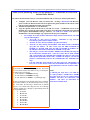
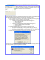
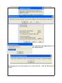
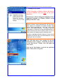
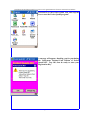
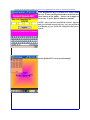
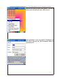
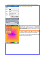
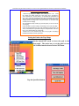
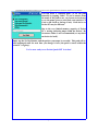
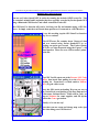
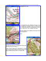
Installation & Quick Start Guide for Prosurv Pocket Quads.NET™ Yellowstone National Park Edition
Prosurv Pocket Quads.NET™
Yellowstone & Grand Teton
National Parks
Edition
Version 1.5
Installation
& Quick Start Guide
For Windows Mobile 2003
And Windows Mobile 2003SE
Pocket PC’s
Contact Information
Prosurv, LLC
185 Louis Lamour Lane
Clark, WY 82435
Toll-free 888-647-9500
Web site: www.prosurv.com
E-mail: [email protected]
[email protected]
Page 1
Installation & Quick Start Guide for Prosurv Pocket Quads.NET™ Yellowstone National Park Edition
Thank you for purchasing Prosurv Pocket Quads.NET™ Yellowstone & Grand Teton
National Parks Edition!
Please follow the instructions below for successful installation and use of Prosurv Pocket Quads.NET™.
1.
Configure your GPS Receiver with your Pocket PC. If using a Bluetooth® GPS Receiver,
please consult our Bluetooth GPS with Pocket Quads.NET guide, included on the CD for establish successful communication with your Pocket PC.
2. Install Pocket Quads.NET on your Pocket PC.
3. Copy the \Quads\ folder from the CD to your SD or CF card. A 1GB Flash card is recommended, since copying all of the Quads (topo maps) for Yellowstone and Grand Teton national
parks requires about 650MB of storage. However, you could use a smaller card, such as a
512MB SD or CF card and simply copy a portion of the pre-processed Quads.
• For example, if you only need the Yellowstone maps (and not Grand Teton), you could
copy the following files:
• All of the “C” files, such as C43110A1. Remember to copy both the
C43110A1.pcq file and the C43110A1 folder!
• All of the “F” files, such as F43109E1 (.pcq files and folders)
• All of the “O” files, starting with O44109xx AND ABOVE such as O44109A8
(.pcq files and folders). In other words, ALL OF THE LATITUDE 44
NORTH “O” QUADS AND ALL OF THE LATITUDE 45 NORTH “O”
QUADS, BUT NOT THE LATITUDE 43 NORTH “O” QUADS.
• This will give you all of the 1:24,000, 1:100,000, and 1:250,000 scale maps for
all of Yellowstone National Park. Total size of these files is about 471MB.
And, you’ll still have the 1:100,000 and 1:250,000 scale maps for both parks.
When Pocket Quads.NET doesn’t find a 1:24,000 scale map for your current
position, it automatically looks for the 1:100,000 (then the 1:250,000) scale
map.
• Copy the USGS WY Names.cdb file to your SD or CF Card. This database allows you to use the Feature Name Search and Radial Search capabilities of
Pocket Quads.NET. File size is about 7.1MB.
USGS Map Names
The file names for each map are very significant. The USGS
uses a file name structure that makes it easy to identify the NOTE:
type and location of each map:
By following the steps above, you could use
• A “C” indicates a 1:250,000 scale map
two cards (perhaps a 512MB and a 256MB)
• An “F” indicates a 1:100,000 scale map
and switch cards for the two National Parks
• An “O” indicates a 1:24,000 (7.5’ Quadrangle) map
(O44109xx and above for Yellowstone, and
O43109xx and above (to O43111H2) for
The first two numbers are the bottom right corner’s Latitude. Grand Teton National Park.
The next three numbers are the bottom right corner’s Longitude. From there, the Lat/Long is divided into 8 columns
and rows. For 1:24,000 scale maps, the rows are A through
H and the columns are 1 through 8, again starting from the
lower right hand corner:
• A or 1=0’
• B or 2=7.5’
• C or 3=15’
• D or 4=22.5’
• E or 5=30’
• F or 6=37.5’
• G or 7=45’
• H or 8=52.5’
Page 2
Installation & Quick Start Guide for Prosurv Pocket Quads.NET™ Yellowstone National Park Edition
Before installing the Prosurv software, make sure that your
Microsoft ActiveSync® program is running, and that it displays “Connected” and “Synchronized”.
Pocket Quads.NET Yellowstone National Park Edition CD contains two installation files.
Select the installation file that matches your Pocket PC’s operating system:
1. You can check the version of your Pocket PC operating system by going to
Start->Settings->System ->About on your Pocket PC:
• A Pocket PC running Windows Mobile 2003 will appear as
• Microsoft® Pocket PC
• Version 4.20.xxxx
• A Pocket PC running Windows Mobile 2003SE will appear as
• Windows Mobile™ 2003 Second Edition
• Version 4.21.xxxx
2. Locate the installation file for your Pocket PC’s operating system
• For Windows Mobile 2003, use Pocket Quads.NET 1.5 for 2003.exe
• For Windows Mobile 2003SE, use Pocket Quads.NET 1.5 for 2003SE.exe
3. Double-click the installation file that matches your operating system.
You must agree to the terms shown above by clicking Yes. The self-extracting software is
now ready to install. Tap the Setup button to continue:
Page 3
Installation & Quick Start Guide for Prosurv Pocket Quads.NET™ Yellowstone National Park Edition
The application and supporting files are
now being installed…
The programs have now been copied over to your Pocket PC. Click the OK button on
your PC.
Page 4
Installation & Quick Start Guide for Prosurv Pocket Quads.NET™ Yellowstone National Park Edition
<—Nothing to worry about.
NOTE: If installing to Windows Mobile 2003 Devices,
(not Second Edition), then you won’t see the screen
shown here.
This message is shown during the installation of the 3
supporting programs on Windows 2003SE (second
edition) Pocket PC’s only.
Why am I seeing this screen? The 3 supporting programs required for Prosurv Pocket Quads.NET have not been specifically compiled for installation onto 2003SE machines, while
Prosurv Pocket Quads.NET has. That’s why you’ll see this
screen 3 time during installation. According to Microsoft:
“This dialog is to advise the user that the application they are
about to use may not be aware of square screens or screen rotation, and may not display properly in landscape mode”.
Since the 3 supporting programs required for Prosurv Pocket
Quads.NET do not have any screen-related functions, you can
simply ignore the screens shown.
Click OK, then wait a few seconds for the next
(identical) screen to appear. Click OK once more to
see the final screen. Finally, click OK again and
you’re done!
Click on the Start button to activate the pull-down
menu. Then, click on Programs.
Page 5
Installation & Quick Start Guide for Prosurv Pocket Quads.NET™ Yellowstone National Park Edition
Scroll down to the Pocket Quads icon, then tap the
icon to start the Pocket Quads program!
A message will appear, thanking you for purchasing
the Yellowstone National Park Edition of Pocket
Quads.NET. Tap OK, then be ready to enter your
Registration Key.
Page 6
Installation & Quick Start Guide for Prosurv Pocket Quads.NET™ Yellowstone National Park Edition
Your Registration Key is located on a sticker inside
the case. Enter your Registration Key in the four text
boxes shown on the display. Letters can be upper or
lower case. Tap the Register button to continue.
NOTE: Once you have installed the Prosurv software
and received and entered your key, you can perform a
Full Backup of your Pocket PC using Microsoft ActiveSync®.
Pocket Quads.NET is now up and running!
Page 7
Installation & Quick Start Guide for Prosurv Pocket Quads.NET™ Yellowstone National Park Edition
Click on New File to create a new job file. The file is
where your GPS and other data will be stored.
Enter the name of your new job file. By default, job
files will be stored in the \My Documents\ folder of
your Pocket PC.
Page 8
Installation & Quick Start Guide for Prosurv Pocket Quads.NET™ Yellowstone National Park Edition
Click OK to create the new job file.
Each topo quad sheet, or image, is made up of dozens of
smaller-sized tiles. These tiles, or slices, are automatically
loaded by Prosurv when needed, based on your GPS position.
Also, you can manually load slices by tapping within one of the
squares on the Overview.
The large rectangle on the upper left side of the
screen (below, left) is called the Overview display.
The Overview also shows the current Quad name and
the name of your current Job file.
Page 9
Installation & Quick Start Guide for Prosurv Pocket Quads.NET™ Yellowstone National Park Edition
Info about the Pre-Processed Topo maps.
•
•
•
•
•
A full-sized Topo Map can be 30MB or more when opened on a PC. Pocket
PC’s simply can’t handle opening such a large image, due to the limited resources of Pocket PC’s (such as memory). So, instead, Pocket Quads.NET uses
tiles or slices of the map and loads the correct slice automatically when needed.
The pre-processed topo maps included in this Edition were created using Prosurv
Imaging’s Batch Processing routine. The processed slices are stored in a folder
created by Prosurv Imaging.
Since this Edition already contains pre-processed Quads, you do not need Prosurv Imaging.
Inside each folder are dozens of images. Each image is a slice of the Topo Map.
Prosurv Pocket Quads.NET uses the .pcq file to identify the maps and slices. So,
when you manually load a Quad sheet (using the Load Quad Sheet menu selection), you’re actually loading the .pcq file itself.
You don’t have to worry about the maps, slices, or the pcq file. Everything is
handled automatically by Pocket Quads.NET.
Setting the Path to the Topo Maps
Pocket Quads.NET needs to know the path to the
topo maps. The easiest way to set the path is to use
the Utilities function located in the GPS Menu.
Tap the Quad Path button.
Page 10
Installation & Quick Start Guide for Prosurv Pocket Quads.NET™ Yellowstone National Park Edition
You can select a ‘standard path’, or set the path
manually by tapping ‘Other’. If you’re unsure about
the name of the path to use, you can use ActiveSync®
to see the name given to your flash card (such as CF
Card or SD Card or Storage Card). Each device or
Pocket PC may be different.
Due to the very limited memory capacity of Pocket
PC’s, storing and using maps within the devices’ My
Documents folder is not recommended (or anywhere
on the device itself).
Simply tap the Set Path button, and the path to your maps is recorded. This path will remain unchanged until the next time you change it here (the path is stored within the
Pocket PC’s registry).
You’re now ready to see Pocket Quads.NET in Action!
Page 11
Installation & Quick Start Guide for Prosurv Pocket Quads.NET™ Yellowstone National Park Edition
Running the GPSTest.txt File
You can see Pocket Quads.NET in action by running the included GPSTest.txt file. This
file contains Latitudes and Longitudes that were actually recorded by Pocket Quads.NET
using a Bluetooth GPS Receiver and a Dell Axim X50v Pocket PC.
The GPS Data Test function will read a Lat/Long text file and simulate using a GPS Receiver. It simply reads the text file and then operates as if connected to a GPS Receiver.
To see this working, tap the GPS Data Test function.
Tap Yes to continue.
This GPSTest.txt file contains about 2 hours of data
and was created using Pocket Quads.NET by recording one point per second. The Pocket Quads.
NET file was then Exported using the Export—>All
Data function. There are over 6700 recorded ‘points’
in the file.
The GPS Test file starts out at the Prosurv LLC Cody
Office, then heads East, pulling in to the Albertson’s
parking lot. From there, we head south to McDonald’s (to grab a bite to eat).
Next, the GPS tracks us heading West on our way to
the North Fork (road leading to the East Entrance of
Yellowstone National Park). While still in Cody, we
stop at Walmart for some supplies, and fill up the
tank at the Cenex gas station.
Finally, we’re on our way!
Note that you can zoom and change map scales just
like when using your GPS Receiver.
Page 12
Installation & Quick Start Guide for Prosurv Pocket Quads.NET™ Yellowstone National Park Edition
...Heading out of Cody.
We’ve included all of the 1:24,000 scale maps (as well
as 1:100,000 and 1:250,000) to take you from Cody,
WY to the East Entrance of Yellowstone National
Park! (Shown here is the 1:250,000 scale map).
Read the complete user’s manual to learn more about
Pocket Quads.NET.
Enjoy!
Note that some roads have changed since the last update of the USGS Topo Maps.—>
Prosurv Pocket Quads.NET Yellowstone & Grand
Teton National Parks Edition includes the latest Topo
Maps available from the USGS as of April, 2005.
Page 13