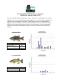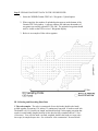
1
Appendix A: WDNR 2012 Spring Netting
Survey and Walleye Population Estimates
Late-Spring Electrofishing Survey Summary
Sand Lake, Sawyer County, 2012
The Hayward DNR Fisheries Management Team conducted an electrofishing survey on Sand
Lake on June 5 as part of our baseline monitoring program. A total of 4 miles of shoreline was
sampled (1 mile sub-sampled for panfish). Primary target species were smallmouth bass,
largemouth bass, and bluegill. We also obtained useful data on the status of juvenile walleye.
Quality, preferred, and memorable sizes referenced in this summary are based on standard
proportions of world record lengths developed for each species by the American Fisheries
Society.
Smallmouth Bass
Captured 7 per mile ≥ 7”
Quality Size ≥ 11”
26%
Preferred Size ≥ 14”
19%
Memorable Size ≥ 17”
7%
Largemouth Bass
Captured 2 per mile ≥ 8”
Quality Size ≥ 12”
67%
Preferred Size ≥ 15”
0%
Bluegill
Captured 25 per mile ≥ 3”
“Keeper” Size ≥ 7”
80%
Preferred Size ≥ 8”
12%
Walleye
Captured 26 per mile <10 ”
Summary of Results
Water temperature at the time of this survey was 66°F, appropriate for sampling spawning bass
and pre-spawn bluegill. Electrofishing effort was spread throughout the lake and covered a
variety of habitat types. The north side of the lake had predominantly sandy substrate with little
woody or vegetative cover; considerably fewer fish were sampled there than on the south side of
the lake, which had more stumps and aquatic vegetation.
Smallmouth bass were found in relatively low numbers, possibly because predation by abundant
walleye is very efficient in lakes with few areas of rock cobble where young smallmouth bass
prefer to hide. The smallmouth population was dominated by smaller individuals. Growth rate
and maximum size of smallmouth in Sand Lake are likely limited by the prey base. Smallmouth
bass prefer to eat crayfish, which do not seem abundant in Sand Lake due to a scarcity of rocky
substrate.
Largemouth bass were found in trace numbers. While many other lakes in the area have
experienced a decrease in walleye abundance concurrent with an increase in largemouth bass
abundance, Sand Lake has remained a walleye-dominant system. Because of their abundance and
effectiveness as predators, walleye are likely limiting natural recruitment of both bass species as
well as panfish – a pattern that has been observed in other area lakes with deep, clear water and
few aquatic plants.
Bluegills were found in low numbers with a relatively high proportion of keeper-size fish. The
fast growth that appears to be present in the population is likely made possible by the presence of
a dense walleye population that continually thins the number of small bluegill, preventing
“stunting” from occurring. The relatively low population of keeper-size fish renders this
population vulnerable to angler over-harvest under a liberal daily bag limit of 25 panfish.
We also sampled many young walleyes 6 to 8 inches long. These fish were just over one year
old, providing evidence of strong natural reproduction of walleye in 2011 at Sand Lake, which
has not been stocked since the restoration project was completed.
Report by Max Wolter – Fisheries Biologist, Sawyer County
Data compiled by Scott Braden – LTE Fisheries Technician
Reviewed by Approved by Dave Neuswanger – Fisheries Supervisor, Hayward Field Unit
2012 Spring Netting Summary- Sand Lake, Sawyer County
Fisheries Research, Spooner
Background: Sound management of muskellunge fisheries requires clear understanding of growth
rates and mortality, factors that determine population size structure. Of particular interest to
managers and anglers is the relation between harvest regulations and growth potential. Size
limits for trophy muskellunge fisheries should be set at levels that allow harvest of trophy fish but
limit exploitation and mortality at smaller sizes, allowing fish to achieve their full growth
potential. Traditional methods of aging fish include reading patterns of annuli from scales or
cleithra (bones located in the pectoral girdle). Scales allow reasonable age estimation in younger
fish but accuracy diminishes with increasing age. Aging based on cleithra relies on lethal
sampling, which restricts samples to voluntary returns from harvested fish, or fish sampled for
purposes such as contaminant sampling. Because age and growth records of muskellunge are
generally characterized by small sample sizes and are variable among lakes, population modeling
often relies on assumptions about growth and mortality that cannot be validated with reliable
empirical data. Therefore, we are evaluating alternative methods for determining lake-specific
growth rates of muskellunge in a set of study lakes, including Sand Lake.
The study is being conducted within lakes that are stocked by WDNR, and currently
assumed to have negligible natural reproduction. Stocked fingerlings will be given passive
integrated transponder, or PIT tags. These are small tags that produce a unique signal that can
identify individual fish throughout their lives. These tags will allow the tracking of known-age
fish throughout their lives, so that future sampling efforts will produce accurate records of age
and growth. As the fish grow and mature, we can produce larger samples of accurately aged fish,
and improve estimates of longevity and growth potential. We can also produce better estimates
of survival rates of stocked fish, and infer the contribution of natural reproduction. This
information improves understanding of muskellunge biology and management.
The study will also track adult muskellunge density by conducting population estimates
with spring netting surveys. Population estimates require two consecutive years of fyke net
surveys. Fish netted during the first year are usually marked with a fin clip, although the marking
technique used in this study is tagging with a passive integrated transponder (PIT tag). The ratio
of marked to unmarked fish during sampling conducted the second year is used to estimate the
total adult population. PIT tags will allow us to identify individual fish and track growth from the
time of capture. However, the primary objective of adult sampling is to estimate density, a factor
known to be important to growth rates.
The current study plans call for stocking 5 year classes of PIT tagged fingerlings in
alternate years, and two mark-recapture adult population estimates. Sand Lake was stocked with
PIT tagged fingerlings during 2009 and 2011. The project will be evaluated for costeffectiveness based on survival rates of stocked fish after 10 years, and will be continued if
survival rates are sufficiently high and funding and staffing are available.
Methods: Adult muskellunge were sampled with fyke nets. Nets were fished overnight and
checked daily throughout the sample period. Muskellunge were measured (total length, inches)
and tagged with a PIT tag, which provides a unique code to identify the fish. Muskellunge were
released after handling. Walleye were measured and released. Walleye length data were
provided to GLIFWC to supplement their walleye population estimate, but are not reported here.
Baseline monitoring data were also collected for two days and provided to Upper Chippewa
Basin biologists, but are not reported here.
Sample locations were based on habitat and records from previous WDNR surveys. Nets
were set after ice-out, beginning 3/23. Nets were moved or removed based on observed trends in
catch rates and water temperature, with the last nets removed on 4/4.
Results and discussion: Twenty-seven muskellunge with total length >20” were handled during
72 net lifts, for an average of 0.37 fish/net lift, which is nearly identical to the catch rate of
0.35/net lift observed during 2011. Overall, the average length of adult muskellunge sampled
was 36.8 inches total length, which is not significantly different than the mean of 36.9 observed
during 2011. Size distribution is shown in Figure 1. Seven fish 40 inches or larger were
sampled.
An early ice out followed by cool weather made for another unusual spring netting season
during 2012 Catch rates were lower than expected, with a small number of fish marked during
2011 recaptured during 2012. The estimated population using a modified Peterson estimate was
185 ± 137. The wide 95% confidence limits are the result of the small recapture sample. The
estimate of 0.20 adult muskellunge per acre (185 fish/928 acres) is below the statewide average,
which is about 0.33 fish per acre, but is not unusually low. Lakes with moderate to low densities
of muskellunge generally support higher growth rates than high density musky lakes.
Several juvenile muskellunge were observed in fyke nets during 2012. Most of the
juvenile muskellunge contained PIT tags, which allowed calculation of growth from the time they
were stocked (September, 2011) until spring. The mean growth increment was 1.54” total length.
Most of the growth probably occurred during fall 2011. The growth of the fish indicates that they
were in good condition at the time of stocking. Four untagged individuals were examined for
evidence of tag loss. The tagged fish ranged in size from 12.1” TL to 14.0” TL. One untagged
individual was slightly larger than the tagged individuals (15.1), had no evidence of scarring from
a tag, and was likely the product of natural reproduction during 2010. Another untagged fish was
smaller (10.5” TL), also lacked evidence of tagging, and was likely the product of natural
recruitment during 2011. These fish provide evidence that limited natural recruitment is
occurring in Sand Lake.
Figure 1. Length (total length, inches) frequency distribution of muskellunge >20” TL sampled
in Sand Lake, Sawyer County WI during spring 2012.
7
6
4
3
2
1
Total Length (in)
47
45
43
41
39
37
35
33
31
29
27
0
25
Frequency
5
SPRING ADULT WALLEYE POPULATION ESTIMATE
LAKE: SAND L
COUNTY: SAWYER
YEAR: 2012
AREA: 928
RECRUITMENT CODE: C-ST
AGENCY: GLIFWC
POPULATION ESTIMATE SUMMARIES
COMBINED SEXES AND UNKNOWNS 15 INCHES AND GREATER
LENGTH
INTERVAL
(INCHES)
0 - 11.9
12 - 14.9
15 - 19.9
20 +
TOTAL:
TOTAL
GIVEN
MARK
120
1,931
617
12
2,680
MARKED
TOTAL
FISH
UNMARKED
MARKED POPULATION
FISH
SPEARED
TOTAL
FISH
FISH
ESTIMATE
SPEARED
BEFORE
ADJUSTED CAUGHT IN CAUGHT IN CAUGHT IN
BEFORE
BEFORE POPULATION
RECAPTURE
NUMBER RECAPTURE RECAPTURE RECAPTURE SPEARING RECAPTURE ESTIMATE STANDARD
SURVEY
MARKED (M) SURVEY (C)
SURVEY
SURVEY (R) ADJUSTMENT SURVEY
(N)
DEVIATION
0
120
12
6
6
225
0
225
54
2
1,929
222
145
77
5,518
39
5,557
501
3
614
52
37
15
2,037
17
2,054
413
0
12
0
0
0
13
1
14
0
5
2,675
286
188
98
7,793
57
7,850
651
POPULATION ESTIMATE:
WALLEYE/ACRE:
LENGTH
INTERVAL
(INCHES)
0 - 11.9
12 - 14.9
15 - 19.9
20 +
TOTAL:
TOTAL
GIVEN
MARK
120
1893
397
0
2,410
TOTAL
GIVEN
MARK
0
38
175
9
222
TOTAL
GIVEN
MARK
10
62
45
3
120
651
8.29%
6,993
7.54
STANDARD DEVIATION:
COEFF. OF VARIATION:
581
8.30%
FEMALES
MARKED
TOTAL
FISH
UNMARKED
MARKED POPULATION
FISH
SPEARED
TOTAL
FISH
FISH
ESTIMATE
SPEARED
BEFORE
ADJUSTED CAUGHT IN CAUGHT IN CAUGHT IN
BEFORE
BEFORE POPULATION
RECAPTURE
NUMBER RECAPTURE RECAPTURE RECAPTURE SPEARING RECAPTURE ESTIMATE STANDARD
SURVEY
MARKED (M) SURVEY (C)
SURVEY
SURVEY (R) ADJUSTMENT SURVEY
(N)
DEVIATION
0
0
0
0
0
1
0
1
0
0
38
2
1
1
59
0
59
20
0
175
14
10
4
528
3
531
176
0
9
0
0
0
10
1
11
0
0
222
16
11
5
598
4
602
177
POPULATION ESTIMATE:
WALLEYE/ACRE:
LENGTH
INTERVAL
(INCHES)
0 - 11.9
12 - 14.9
15 - 19.9
20 +
TOTAL:
STANDARD DEVIATION:
COEFF. OF VARIATION:
MALES
MARKED
TOTAL
FISH
UNMARKED
MARKED POPULATION
FISH
SPEARED
TOTAL
FISH
FISH
ESTIMATE
SPEARED
BEFORE
ADJUSTED CAUGHT IN CAUGHT IN CAUGHT IN
BEFORE
BEFORE POPULATION
RECAPTURE
NUMBER RECAPTURE RECAPTURE RECAPTURE SPEARING RECAPTURE ESTIMATE STANDARD
SURVEY
MARKED (M) SURVEY (C)
SURVEY
SURVEY (R) ADJUSTMENT SURVEY
(N)
DEVIATION
0
120
12
6
6
225
0
225
54
2
1891
220
144
76
5,430
39
5,469
496
3
394
38
27
11
1,284
14
1,298
296
0
0
0
0
0
1
0
1
0
5
2,405
270
177
93
6,940
53
6,993
581
POPULATION ESTIMATE:
WALLEYE/ACRE:
LENGTH
INTERVAL
(INCHES)
0 - 11.9
12 - 14.9
15 - 19.9
20 +
TOTAL:
7,850
8.46
602
0.65
STANDARD DEVIATION:
COEFF. OF VARIATION:
177
29.44%
UNKNOWNS
SAMPLING SUMMARY
MARKED
TOTAL
MARKING RECAPTURE
FISH
UNMARKED
MARKED
FISH
SURVEYS
SURVEY
SPEARED
TOTAL
FISH
FISH
SPEARED
DATES: 3/23-4/1/2012
4/2/2012
BEFORE
ADJUSTED CAUGHT IN CAUGHT IN CAUGHT IN
BEFORE
RECAPTURE
NUMBER RECAPTURE RECAPTURE RECAPTURE RECAPTURE
GEAR USED:
E/F
E
SURVEY
MARKED (M) SURVEY (C)
SURVEY
SURVEY (R)
SURVEY
0
10
0
0
0
0
FIN CLIP:
TC
TC
1
61
0
0
0
2
0
45
0
0
0
0
TAGS:
0
3
0
0
0
0
1
119
0
0
0
2
REPORT PRINT DATE: 7/16/2012
Page 1
LAKE: SAND L
COUNTY: SAWYER
YEAR: 2012
LENGTH INTERVAL
(INCHES)
5.0
5.49
5.5
5.99
6.0
6.49
6.5
6.99
7.0
7.49
7.5
7.99
8.0
8.49
8.5
8.99
9.0
9.49
9.5
9.99
10.0
- 10.49
10.5
- 10.99
11.0
- 11.49
11.5
- 11.99
12.0
- 12.49
12.5
- 12.99
13.0
- 13.49
13.5
- 13.99
14.0
- 14.49
14.5
- 14.99
15.0
- 15.49
15.5
- 15.99
16.0
- 16.49
16.5
- 16.99
17.0
- 17.49
17.5
- 17.99
18.0
- 18.49
18.5
- 18.99
19.0
- 19.49
19.5
- 19.99
20.0
- 20.49
20.5
- 20.99
21.0
- 21.49
21.5
- 21.99
22.0
- 22.49
22.5
- 22.99
23.0
- 23.49
23.5
- 23.99
24.0
- 24.49
24.5
- 24.99
25.0
- 25.49
25.5
- 25.99
26.0
- 26.49
26.5
- 26.99
27.0
- 27.49
27.5
- 27.99
28.0
- 28.49
28.5
- 28.99
29.0
- 29.49
29.5
- 29.99
30.0
- 30.49
30.5
- 30.99
31.0
- 31.49
31.5
- 31.99
TOTAL:
AREA: 928
RECRUITMENT CODE: C-ST
AGENCY: GLIFWC
WALLEYE LENGTH FREQUENCY
MARKING PERIOD: MARKED
RECAP PERIOD: UNMARKED
MALE
FEMALE UNKNOWN
MALE
FEMALE UNKNOWN
0
0
0
0
0
0
0
0
0
0
0
0
0
0
0
0
0
0
0
0
0
0
0
0
0
0
0
0
0
0
0
0
0
0
0
0
0
0
0
0
0
0
0
0
0
0
0
0
0
0
0
0
0
0
0
0
0
0
0
0
3
0
0
0
0
0
3
0
0
2
0
0
24
0
1
0
0
0
90
0
9
4
0
0
279
0
9
15
0
0
389
1
13
42
0
0
418
1
16
34
0
0
297
5
5
19
0
0
271
10
5
19
0
0
239
21
14
15
1
0
199
33
13
12
0
0
106
32
14
10
4
0
57
41
10
2
3
0
18
23
4
2
0
0
10
21
2
1
1
0
5
15
0
0
1
0
2
6
0
0
0
0
0
3
1
0
0
0
0
1
0
0
1
0
0
0
1
0
0
0
0
0
0
0
0
0
0
1
0
0
0
0
0
3
0
0
0
0
0
1
0
0
0
0
0
0
0
0
0
0
0
0
0
0
0
0
0
1
0
0
0
0
0
1
0
0
0
0
0
0
1
0
0
0
0
0
0
0
0
0
0
0
1
0
0
0
0
0
0
0
0
0
0
0
1
0
0
0
0
1
0
0
0
0
0
0
0
0
0
0
0
0
0
0
0
0
0
1
0
0
0
0
0
0
0
0
0
0
0
0
0
0
0
0
0
0
0
0
0
0
0
0
0
0
0
0
0
0
0
0
0
0
0
0
0
0
0
0
0
0
0
0
0
0
120
177
11
0
2410
222
Page 2
RECAP PERIOD: RECAPS
MALE
FEMALE UNKNOWN
0
0
0
0
0
0
0
0
0
0
0
0
0
0
0
0
0
0
0
0
0
0
0
0
0
0
0
0
0
0
0
0
0
0
0
0
0
0
0
6
0
0
6
0
0
22
0
0
14
0
0
13
0
0
12
0
0
9
1
0
10
1
0
1
0
0
0
0
0
0
0
0
0
2
0
0
0
0
0
1
0
0
0
0
0
0
0
0
0
0
0
0
0
0
0
0
0
0
0
0
0
0
0
0
0
0
0
0
0
0
0
0
0
0
0
0
0
0
0
0
0
0
0
0
0
0
0
0
0
0
0
0
0
0
0
0
0
0
0
0
0
0
0
0
0
0
0
0
0
0
0
0
0
0
0
0
0
0
0
0
0
0
93
5
0
LAKE: SAND L
COUNTY: SAWYER
YEAR: 2012
AREA: 928
RECRUITMENT CODE: C-ST
AGENCY: GLIFWC
LENGTH FREQUENCY OF SPEARED WALLEYE
BEFORE RECAPTURE SURVEY
SPEARING DATES: 3/29/2012
SPEARING ADJUSTMENT USED? YES
LENGTH INTERVAL
UNMARKED
MARKED
TOTAL
(INCHES)
MALE
FEMALE UNKNOWN
MALE
FEMALE UNKNOWN
MALE
FEMALE UNKNOWN
5.0
5.99
0
0
0
0
0
0
0
0
0
6.0
6.99
0
0
0
0
0
0
0
0
0
7.0
7.99
0
0
0
0
0
0
0
0
0
8.0
8.99
0
0
0
0
0
0
0
0
0
9.0
9.99
0
0
0
0
0
0
0
0
0
10.0
- 10.99
0
0
0
0
0
0
0
0
0
11.0
- 11.99
0
0
0
0
0
0
0
0
0
12.0
- 12.99
11
0
0
0
0
0
11
0
0
13.0
- 13.99
8
0
0
2
0
0
10
0
0
14.0
- 14.99
18
0
1
0
0
1
18
0
2
15.0
- 15.99
10
1
0
2
0
0
12
1
0
16.0
- 16.99
1
2
0
1
0
0
2
2
0
17.0
- 17.99
0
0
0
0
0
0
0
0
0
18.0
- 18.99
0
0
0
0
0
0
0
0
0
19.0
- 19.99
0
0
0
0
0
0
0
0
0
20.0
- 20.99
0
0
0
0
0
0
0
0
0
21.0
- 21.99
0
0
0
0
0
0
0
0
0
22.0
- 22.99
0
0
0
0
0
0
0
0
0
23.0
- 23.99
0
1
0
0
0
0
0
1
0
24.0
- 24.99
0
0
0
0
0
0
0
0
0
25.0
- 25.99
0
0
0
0
0
0
0
0
0
26.0
- 26.99
0
0
0
0
0
0
0
0
0
27.0
- 27.99
0
0
0
0
0
0
0
0
0
28.0
- 28.99
0
0
0
0
0
0
0
0
0
29.0
- 29.99
0
0
0
0
0
0
0
0
0
30.0
- 30.99
0
0
0
0
0
0
0
0
0
31.0
- 31.99
0
0
0
0
0
0
0
0
0
TOTAL:
48
4
1
5
0
1
53
4
2
TOTAL
0
0
0
0
0
0
0
11
10
20
13
4
0
0
0
0
0
0
1
0
0
0
0
0
0
0
0
59
AFTER RECAPTURE SURVEY
LENGTH INTERVAL
(INCHES)
MALE
5.0
5.99
0
6.0
6.99
0
7.0
7.99
0
8.0
8.99
0
9.0
9.99
0
10.0
- 10.99
0
11.0
- 11.99
0
12.0
- 12.99
0
13.0
- 13.99
0
14.0
- 14.99
0
15.0
- 15.99
0
16.0
- 16.99
0
17.0
- 17.99
0
18.0
- 18.99
0
19.0
- 19.99
0
20.0
- 20.99
0
21.0
- 21.99
0
22.0
- 22.99
0
23.0
- 23.99
0
24.0
- 24.99
0
25.0
- 25.99
0
26.0
- 26.99
0
- 27.99
0
27.0
28.0
- 28.99
0
29.0
- 29.99
0
30.0
- 30.99
0
31.0
- 31.99
0
TOTAL:
0
TOTAL
0
0
0
0
0
0
0
0
0
0
0
0
0
0
0
0
0
0
0
0
0
0
0
0
0
0
0
0
SPEARING DATES:
UNMARKED
FEMALE UNKNOWN
MALE
0
0
0
0
0
0
0
0
0
0
0
0
0
0
0
0
0
0
0
0
0
0
0
0
0
0
0
0
0
0
0
0
0
0
0
0
0
0
0
0
0
0
0
0
0
0
0
0
0
0
0
0
0
0
0
0
0
0
0
0
0
0
0
0
0
0
0
0
0
0
0
0
0
0
0
0
0
0
0
0
0
0
0
0
MARKED
FEMALE
0
0
0
0
0
0
0
0
0
0
0
0
0
0
0
0
0
0
0
0
0
0
0
0
0
0
0
0
Page 3
UNKNOWN
0
0
0
0
0
0
0
0
0
0
0
0
0
0
0
0
0
0
0
0
0
0
0
0
0
0
0
0
MALE
0
0
0
0
0
0
0
0
0
0
0
0
0
0
0
0
0
0
0
0
0
0
0
0
0
0
0
0
TOTAL
FEMALE UNKNOWN
0
0
0
0
0
0
0
0
0
0
0
0
0
0
0
0
0
0
0
0
0
0
0
0
0
0
0
0
0
0
0
0
0
0
0
0
0
0
0
0
0
0
0
0
0
0
0
0
0
0
0
0
0
0
0
0
LAKE: SAND L
COUNTY: SAWYER
YEAR: 2012
SIZE
CLASS
INCH
GROUP
5
6
7
0-11.9
8
9
10
11
SUB-TOTAL:
12
12-14.9
13
14
SUB-TOTAL:
15
16
15-19.9
17
18
19
SUB-TOTAL:
20
21
22
23
24
25
20 +
26
27
28
29
30
31
SUB-TOTAL:
SPAWNING TOTAL:
UNKNOWNS < 15":
GRAND TOTAL:
AREA: 928
RECRUITMENT CODE: C-ST
AGENCY: GLIFWC
SPAWNING POPULATION SIZE DISTRIBUTION
NUMBER
SAMPLE
POPULATION
ESTIMATED
SAMPLED
PROPORTION
ESTIMATE
NUMBER
0
0.000
0
0
0.000
0
0
0.000
0
0
0.000
225
0
0
0.000
0
8
0.063
14
118
0.937
210
126
726
0.350
1,943
774
0.373
5,557
2,072
576
0.277
1,542
2,076
423
0.647
1,329
160
0.245
503
56
0.086
2,054
176
12
0.018
38
3
0.005
9
654
1
0.083
1
4
0.333
5
0
0.000
0
2
0.167
2
1
0.083
1
1
0.083
1
2
0.167
14
2
0
0.000
0
1
0.083
1
0
0.000
0
0
0.000
0
0
0.000
0
12
2,868
7,850
7,850
72
2,940
Page 4
NUMBER
SPEARED
0
0
0
0
0
0
0
0
11
10
18
39
13
4
0
0
0
17
0
0
0
1
0
0
0
0
0
0
0
0
1
57
2
59
PERCENT OF
EST. NUMBER
N/A
N/A
N/A
N/A
N/A
0.00%
0.00%
0.00%
0.57%
0.48%
1.17%
0.70%
0.98%
0.80%
0.00%
0.00%
0.00%
0.83%
0.00%
0.00%
N/A
42.86%
0.00%
0.00%
0.00%
N/A
0.00%
N/A
N/A
N/A
7.14%
0.73%
LAKE: SAND L
COUNTY: SAWYER
YEAR: 2012
AREA: 928
RECRUITMENT CODE: C-ST
AGENCY: GLIFWC
DAILY SUMMARY AND COMMENTS
DATE: 3/24-4/2/2012WATER TEMPERATURE:
COMMENTS:
WDNR Fyke Netting.
NUMBER
SPAWNING CONDITION
NEWLY
(APPROX. PERCENTAGE)
MARKED
HARD
RIPE
SPENT
MALES
56
FEMALES
47
UNKNOWN
70
TOTAL
173
COMMENTS:
Fish were scattered along shoreline.
DATE: 3/23-24/2012WATER TEMPERATURE: 42-46
MALES
FEMALES
UNKNOWN
TOTAL
NUMBER
NEWLY
MARKED
412
115
24
551
SPAWNING CONDITION
(APPROX. PERCENTAGE)
HARD
RIPE
SPENT
0
100
0
100
0
0
DATE: 3/25,28/2012WATER TEMPERATURE: 43/44
MALES
FEMALES
UNKNOWN
TOTAL
NUMBER
NEWLY
MARKED
576
17
1
594
SPAWNING CONDITION
(APPROX. PERCENTAGE)
HARD
RIPE
SPENT
0
100
0
100
0
0
DATE: 3/29-30/2012WATER TEMPERATURE: 44
MALES
FEMALES
UNKNOWN
TOTAL
NUMBER
NEWLY
MARKED
487
24
19
530
COMMENTS:
Most walleye were in 2-4' of water.
SPAWNING CONDITION
(APPROX. PERCENTAGE)
HARD
RIPE
SPENT
0
100
0
100
0
0
DATE: 3/31-4/1/2012WATER TEMPERATURE: 44/47
MALES
FEMALES
UNKNOWN
TOTAL
NUMBER
NEWLY
MARKED
879
19
6
904
DATE: 4/2/2012
MALES
FEMALES
UNKNOWN
TOTAL
NUMBER
NEWLY
MARKED
177
11
0
188
COMMENTS:
Most walleye were found in 3-5' of water.
Bluegill, sucker, and yellow perch were
abundant.
SPAWNING CONDITION
(APPROX. PERCENTAGE)
HARD
RIPE
SPENT
0
95
5
50
50
0
COMMENTS:
Some walleye were tight to the shoreline,
others were still in 2-4' of water.
COMMENTS:
Recapture run, shocked entire shoreline.
WATER TEMPERATURE: 45
SPAWNING CONDITION
(APPROX. PERCENTAGE)
HARD
RIPE
SPENT
0
100
0
50
50
0
Page 5
Sand Lake
Sawyer Co.
928 acres
Marking Survey: 3/23-4/1/2012
WDNR Fyke Net Locations: ___
Main Spawning Areas: - - - -
0
0.25
0.5
1
1.5
2
Miles
Sand Lake
Sawyer Co.
928 acres
Recapture Survey: 4/2/2012
Entire Shoreline Surveyed
0
0.25
0.5
1
1.5
2
Miles
Appendix B: Freshwater Sponge Information
Citizen Monitoring Guide to Wisconsin’s Freshwater Sponges
Dreux J. Watermolen
Wisconsin Department of Natural Resources
What Information Is Being Collected?
Project Overview
Freshwater sponges are aquatic animals that grow in lakes, rivers,
bogs, and streams attached to submerged rocks, sticks, logs, or
aquatic vegetation. They feed by filtering small particles from the
water, and so are thought to be sensitive indicators of pollution.
Wisconsin’s freshwater sponges were studied extensively in the
1930s and found to be growing in many lakes and major river
systems. Since then, extensive studies have not been done, though
some limited research seems to indicate that the range of some
species is more restricted than in the 1930s. This Citizen-based
Monitoring study will try to shed more light on how abundant and
widely distributed Wisconsin’s sponges are today. Through this
project, we are engaging volunteer monitors and creating a database
of probable sponge occurrences that can be further investigated.
Study Area
Citizen volunteers are asked to answer the following questions:
Can We Find Freshwater Sponges in Our Lake or Nearby River?
Sponges grow in relatively shallow water and so can be found by wading and
observing the surfaces where they might grow. You might find a rake useful for
turning over debris. The sponges may be colored green by algae that live inside their
cells or they may be beige to brown or pinkish in color. Sponges can be delicate to
very firm feeling but are not slimy or filmy. Some sponges prefer the underside of
logs and sticks; these are usually not green in color.
Wisconsin’s sponges exhibit an annual life history in which they grow through the
summer, die back in the winter, and begin a new growth cycle in spring. So, it’s best
to look for them in late summer and early fall. In late summer, sponges form
gemmules, small spherical protective structures that contain cells from which new
sponges will grow in spring. The gemmules will appear about the size of poppy
seeds, but are tan in color (arrows in photo, below right). They can be clustered or
scattered in the sponge.
The Citizen Monitoring of Wisconsin’s Freshwater Sponges project
is a statewide inventory program. Citizens throughout the state are
now able to collect and report data on sponge occurrence in their
local lakes and waterways.
Where did you observe sponges?
County: ______________________
Waterbody: __________________________
Substrate where you observed sponges:
__ sand
__ gravel
__ logs
__ other: _________________________
When did you observe sponges?
Date: _____________________
How many kinds of sponges did you observe?
__ All sponges appeared to be the same kind
__ Sponges appeared to be more than one kind
How can we contact you?
Name: __________________________
Address: _____________________________
_____________________________
Telephone: _____________________
E-mail: ______________________________
Where Do Volunteers Send Their Reports?
What Do Freshwater Sponges Look Like?
How Common Are Freshwater Sponges?
Freshwater sponges vary from marble-sized to elongated masses and
can grow to be thin or thick encrusting layers. Their surfaces may be
smooth, textured or wavy, or have finger-like projections (photos at
right). Their structure is supported by spicules, tiny needle-like
structures made of silicon that are distributed throughout the sponge
body. You can use a magnifying glass to see at least a hint of the needlelike spicules.
Unfortunately, color and shape are not particularly helpful in
identifying sponges to the species level. Instead, biologists rely on the
spicules, which are quite diverse in their size, shape, and number of
prongs (photo, lower right). Some have hooks or are dumbbell-shaped.
They can be smooth or spined. Much of this variability is speciesspecific (i.e. each species has its own sizes and shapes).
We don’t know. Since little modern survey research
has been conducted, their conservation status remains
unknown. Biologists have found sponges in fewer than
half of Wisconsin’s counties. So there are many gaps in
our knowledge.
We created a reporting mechanism by which citizens
can help us prioritize waterbodies for future survey
efforts.
Please take one of our brochures and share your
observations.
Volunteers can mail their completed
questionnaires to:
Dreux Watermolen, SS/7
Wisconsin Dept. of Natural Resources
P.O. Box 7921
Madison, WI 53707-7921
Or they can send all of the requested information
by e-mail to [email protected].
Submitted information will be compiled in a
database of probable sponge occurrences.
Acknowledgments
Photographs: Robert Korth and Milwaukee Public Museum
Thanks to Joan Jass, Janis Annesley, and the Milwaukee Public Museum for assistance in developing this sponge
monitoring program and the introductory brochure. This project is supported by the Wisconsin Department of
Natural Resources’ Citizen-Based Monitoring Partnership Program. For more information on the Citizen-Based
Monitoring Partnership Program, see http://cbm.wiatri.net/.
Appendix C: Sand Lake Aquatic Plant Survey
Report
Sand Lake Aquatic Plant Survey
Introduction
This report is a summary and analysis of the data which was collected in a baseline macrophyte
survey of Sand Lake, Sawyer County WI. The macrophyte survey was completed the last week
of August 2012 and followed WI DNR protocol for a point-intercept survey. The entire littoral
zone was also visually surveyed in mid June for the presence of invasive species, of which none
were found.
Field Methods
A point intercept method for the macrophyte sampling was used. The Wisconsin Department of
Natural Resources (WDNR) generated the sampling point grid. This grid consisted of 830 points
(Figure 1). Only points shallower than 20 feet were initially sampled until the maximum depth
of plants could be established. It was determined that the maximum depth of plants was 11 feet.
A total of 279 points were sampled. From those 279 points, 250 points were at depths of 11 feet
or less and 208 of them contained vegetation.
If no plants were sampled at a specific depth, one sample point beyond that depth was sampled
for plants. In addition, any plant within six feet of the boat was recorded. The visually surveyed
plant data is not used in the statistical analysis nor is the density recorded. Only results from the
predetermined sample points were used in the statistical analysis. A handheld Global Positioning
System (GPS) located the sampling points in the field. The Wisconsin DNR guidelines for point
location accuracy were followed with an 80-foot resolution and the location arrow touching the
point.
At each sample location, a double-sided fourteen-tine rake was used to rake a 1 meter tow from
off the bow of the boat. All plants contained on the rake and those that fell off of the rake were
identified and rated as to rake fullness. The rake fullness value was used based on the criteria
contained in the diagram below. Those plants that were within six feet were recorded as
“viewed,” but no rake fullness rating was given.
Figure 1: Sand Lake Sampling Point Grid
The depth and predominant bottom type was also recorded for each sample point. All plants
needing verification were bagged and cooled for later examination.
Data Analysis Methods
The data collected was entered into a spreadsheet for analysis. The following statistics
were generated from the spreadsheet:
•
•
•
•
•
•
•
•
Frequency of occurrence in sample points with vegetation (littoral zone)
Relative frequency
Total sample points
Sample points with vegetation
Simpson’s diversity index
Maximum plant depth
Species richness
Floristic Quality Index
An explanation of each of these data is provided below.
Frequency of occurrence for each species
Frequency is expressed as a percentage by dividing the number of sites the plant is sampled by
the number of total sites. There are two frequency values calculated. The first is the percentage
of all sample points that a plant was sampled at depths less than the maximum depth plants were
found (littoral zone), regardless if vegetation was present. The second is the percentage of
sample points that the plant was sampled out of only points containing vegetation. The first value
shows how often the plant would be encountered in the defined littoral zone, while the second
value considers only points that contain plants. In either case, the greater this value, the more
frequently the plant occurs in the lake. If one wants to compare plants within the littoral zone, we
look at the frequency of all points below maximum depth with plants. This frequency value
allows the analysis of how common plants are in areas where they could grow. If one wants to
focus only on where plants are actually present, then one would look at frequency at points in
which plants were found. Frequency of occurrence is usually reported using sample points where
vegetation was present.
Relative frequency
This value shows, as a percentage, the frequency of a particular plant relative to other plants.
This is not dependent on the number of points sampled. The relative frequency of all plants will
add to 100%. This means that if plant A had a relative frequency of 30%, it occurred 30% of the
time compared to all plants sampled or makes up 30% of all plants sampled. This value allows us
to see which plants are the dominant species in the lake. The higher the relative frequency, the
more common the plant is compared to the other plants.
Total Sample Points
This is the total number of points created for sampling on the lake. This may not be the same as
the actual points sampled. When doing a survey, samples aren’t taken at depths outside of the
littoral zone (the area where plants can grow). Once the maximum depth of plants is established,
many of the points deeper than this are eliminated to save time and effort.
Sample points with vegetation
This is the number of sites where plants were actually sampled. It gives a good idea of the plant
coverage of the lake. If 20% of all grid sample points had vegetation, it implies about 20%
coverage of plants in the whole lake. We also look at the number of sample sites with vegetation
in the littoral zone. If 20% of the littoral zone had sample points with vegetation, then the plant
coverage in the littoral zone would be estimated at 20%.
Simpson’s diversity index
Simpson’s diversity index is calculated to measure how diverse the plant community is. This
value can run from 0 to 1.0. The greater the value, the more diverse the plant community is in a
particular lake. In theory, the value is the chance that two species sampled are different. An
index of “1” means that the two will always be different (very diverse) and a “0” would indicate
that they will never be different (only one species found). The more diverse the plant
community, the better the lake ecosystem.
Maximum depth of plants
This depth indicates the deepest that plants were sampled. Generally lakes with higher water
clarity have a greater depth of plants while lower water clarity limits light penetration and
reduces the depth at which plants are found.
Species richness
The number of different individual species found in the lake. Results include a number for the
species richness of plants sampled, and another number that takes into account plants viewed but
not actually sampled during the survey.
Floristic Quality Index
The Floristic Quality Index (FQI) is an index developed by Dr. Stanley Nichols of the University
of Wisconsin-Extension. This index is a measure of the plant community in response to
development (and human influence) on the lake. It takes into account the species of aquatic
plants found and their tolerance for changing water quality and habitat quality. The index uses a
conservatism value assigned to various plants ranging from 1 to 10. Not all plants have a
conservatism value. A high conservatism value indicates that a plant is intolerant to disturbance
while a lower value indicates tolerance. Those plants with higher values are more apt to respond
adversely to water quality and habitat changes, largely due to human influence.
The FQI is calculated using the number of species and the average conservatism value of all
species used in the index.
The formula is:
FQI = Mean C · √N
Where C is the conservatism value and N is the number of species.
A higher FQI, indicates a healthier aquatic plant community. This value can then be compared to
the mean for other lakes in the assigned eco-region. There are four eco-regions used throughout
Wisconsin. These are Northern Lakes and Forests, Northern Central Hardwood Forests, Driftless
Area, and Southeastern Wisconsin Till Plain. Sand Lake is located in the Northern Lakes and
Forest eco-region. Below is a summary of the FQI median values for the Northern Lakes and
Forest eco-region:
Mean species richness = 13
Mean conservatism = 6.7
1
Mean Floristic Quality = 24.3
1
Floristic Quality Assessment of Wisconsin Lake Plant Communities with Example Applications. Journal of Lake
and Reservoir Management 15 (2): 133-144. 1999.
Results
The Wisconsin Department of Natural Resources generated the sampling point grid for Sand
Lake which consisted of 830 points. Only points shallower than 20 feet were initially sampled
until the maximum depth of plants could be established. This was determined to be 11 feet and is
considered the littoral zone. A total of 250 points were at depths of 11 feet or less and out of
those points, 208 of them contained vegetation. See Table 1 for a summary of the survey
statistics.
Figure 2 shows the points that were sampled at depths of 11 feet or less and can be considered a
map of the littoral zone. It also indicates the type of substrate that was present at each of the
littoral zone sampling points. Sand was the most dominant substrate type (91%) followed by
rock (7%) and then muck (2%).
Figure 2: Sand Lake Littoral Zone and Substrate Type
Muck
Sand
Rock
Species Richness
Twenty-seven species of aquatic macrophytes were directly sampled and observed in Sand Lake
during the August whole lake survey. Table 2 lists all of the species that were sampled or
observed along with their frequency and average rake density.
Table 1: Sand Lake Aquatic Plant Survey Statistics
SUMMARY STATS:
Total number of points sampled
Total number of sites with vegetation
Total number of sites shallower than maximum depth of plants
Frequency of occurrence at sites shallower than maximum depth of
plants
Simpson Diversity Index
Maximum depth of plants (ft)
Number of sites sampled using rake on Rope (R)
Number of sites sampled using rake on Pole (P)
Average number of all species per site (shallower than max depth)
Average number of all species per site (veg. sites only)
Average number of native species per site (shallower than max depth)
Average number of native species per site (veg. sites only)
Species Richness
Species Richness (including visuals)
279
208
250
83.20
0.91
11.00
111
167
2.54
3.06
2.32
3.06
27
27
Table 2: Sand Lake Aquatic Macrophytes
Species Name
Vallisneria
americana
Potamogeton
pusillus
filamentous algae
Najas flexilis
Potamogeton
richardsonii
Potamogeton
amplifolius
isoetes sp.
Schoenoplectus
acutus
Elodea canadensis
Myriophyllum
tenellum
Freq w/in
vegetated
areas
Freq at sites
shallower
than max
depth of
plants
Relative
Freq.
Rake
Density
Wild celery
65.87
54.8
21.5
1
Small pondweed
filamentous
algae
Bushy pondweed
Clasping-leaf
pondweed
Large-leaf
pondweed
quillwort
Hardstem
bulrush
27.4
22.8
9
1
26.44
26.44
22
22
8.6
8.6
1
1
22.12
18.4
7.2
1
21.63
13.94
18
11.6
7.1
4.6
1
1
13.46
11.06
11.2
9.2
4.4
3.6
1
1
11.06
9.2
3.6
1
Common
Name
Common waterweed
Dwarf water
milfoil
Species Name
Potamogeton
illinoensis
Potamogeton
robbinsii
Chara
Potamogeton
zosteriformis
Ceratophyllum
demersum
Schoenoplectus
pungens
Nitella sp.
Nuphar variegata
Megalodonta beckii
Myriophyllum
sibiricum
Ranunculus
aquatilis
Brasenia schreberi
Lemna minor
Equisetum fluviatile
Eriocaulon
aquaticum
Nymphaea odorata
Potamogeton
strictifolius
Freq w/in
vegetated
areas
Freq at sites
shallower
than max
depth of
plants
Relative
Freq.
Rake
Density
Illinois pondweed
Fern Leaf
pondweed
Muskgrasses
Flat-stem
pondweed
10.58
8.8
3.5
1
8.17
7.21
6.8
6
2.7
2.4
1
1
6.73
5.6
2.2
1
Coontail
Three-square
rush
Nitella
Spatterdock
Water marigold
Northern water
milfoil
Stiff water
crowfoot
Watershield
Small duckweed
water horsetail
6.25
5.2
2
1
6.25
5.77
3.37
2.4
5.2
4.8
2.8
2
2
1.9
1.1
0.8
1
2
1
1
1.92
1.6
0.6
1
1.44
1.44
1.44
0.96
1.2
1.2
1.2
0.8
0.5
0.5
0.5
0.3
1
1
1
1
Pipewort
White water lily
0.96
0.96
0.8
0.8
0.3
0.3
1
1
Stiff pondweed
0.48
0.4
0.2
1
Common
Name
Frequency of occurrence within vegetated areas (%): Number of times a species was seen in a vegetated area divided by the
total number of vegetated sites.
Frequency of occurrence at sites shallower than maximum depth of plants: Number of times a species was seen divided by
the total number of sites shallower than maximum depth of plants (whole lake value-how often it occurs within the entire littoral
zone)
Plant Diversity
Sand Lake has a very diverse plant community consisting of 27 native species. The Simpson’s
diversity index is also very high at 0.91 indicating a healthy ecosystem and a high degree of
diversity. No single plant dominates within the lake. The plant species abundance is balanced
between many different types.
Floristic Quality Index
Sand Lake has a very high FQI (32.0). There were 24 species used to calculate the FQI. The
species and their conservatism values are included in Table 3. The mean conservatism value was
6.54. The number of species and FQI are greater than the median values for lakes in the same
eco-region (Northern Lakes and Forests). The mean conservatism value is slightly lower
however. Figure 3 compares these values. The high FQI is indicative of a plant community that
is intolerant to development and other human disturbances in the watershed. It indicates that the
plant community is healthy and has changed little in response to human impact on water quality
and habit (sediment) changes.
Table 3: Plant Conservatism Values
Species Name
Elodea canadensis
Vallisneria americana
Ceratophyllum demersum
Potamogeton
zosteriformis
Chara
Potamogeton strictifolius
Potamogeton robbinsii
filamentous algae
Najas flexilis
Potamogeton pusillus
Nitella sp.
Potamogeton richardsonii
Myriophyllum tenellum
Megalodonta beckii
Myriophyllum sibiricum
Ranunculus aquatilis
isoetes sp.
Equisetum fluviatile
Eriocaulon aquaticum
Potamogeton amplifolius
Potamogeton illinoensis
Schoenoplectus acutus
Brasenia schreberi
Nymphaea odorata
Common Name
Common waterweed
Wild celery
Coontail
Flat-stem pondweed
Muskgrasses
Stiff pondweed
Fern Leaf pondweed
filamentous algae
Bushy pondweed
Small pondweed
Nitella
Clasping-leaf
pondweed
Dwarf water milfoil
Water marigold
Northern water milfoil
Stiff water crowfoot
quillwort
water horsetail
Pipewort
Large-leaf pondweed
Illinois pondweed
Hardstem bulrush
Watershield
White water lily
Conservatism
Value
3
6
3
6
7
8
8
6
7
5
10
8
7
7
8
7
9
7
6
5
7
6
Species Name
Schoenoplectus pungens
Nuphar variegata
Lemna minor
Conservatism
Value
Common Name
Three-square rush
Spatterdock
Small duckweed
6
5
Figure 3: FQI Comparison to Ecoregion Median
Sand Lake FQI and Ecoregion Median
35
30
32
27
24.3
25
20
15
Sand Lake
13
10
Ecoregion Median
6.5
6.7
5
0
No. of Species
Mean C
FQI
Species Distribution Maps
The following maps indicate the locations that the specified plant was surveyed or
visually seen during the August whole lake point-intercept survey.
Vallisneria americana
Wild celery
Potamogeton pusillus
Small pondweed
filamentous algae
Najas flexilis Bushy pondweed
Potamogeton richardsonii Clasping-leaf pondweed
Potamogeton amplifolius
Large-leaf pondweed
isoetes sp.
quillwort
Schoenoplectus acutus
Hardstem bulrush
Elodea canadensis Common waterweed
Myriophyllum tenellum
Dwarf water milfoil
Potamogeton illinoensis
Illinois pondweed
Potamogeton robbinsii
Fern Leaf pondweed
Chara
Muskgrasses
Potamogeton zosteriformis
Flat-stem pondweed
Ceratophyllum demersum Coontail
Schoenoplectus pungens Three-square rush
Nitella sp.
Nitella
Nuphar variegata
Spatterdock
Megalodonta beckii Water marigold
Myriophyllum sibiricum
Northern water milfoil
Ranunculus aquatilis
Stiff water crowfoot
Brasenia schreberi Watershield
Lemna minor
Equisetum fluviatile
Small duckweed
water horsetail
Eriocaulon aquaticum
Pipewort
Nymphaea odorata White water lily
Potamogeton strictifolius
Stiff pondweed
Appendix D. Aquatic Invasive Species Information1 Eurasian Water Milfoil
DESCRIPTION: Eurasian water milfoil is a submersed aquatic plant native to Europe, Asia,
and northern Africa. It is the only non-native milfoil in Wisconsin. Like the native milfoils, the
Eurasian variety has slender stems whorled by submersed feathery leaves and tiny flowers
produced above the water surface. The flowers are located in the axils of the floral bracts, and
are either four-petaled or without petals. The leaves are threadlike, typically uniform in diameter,
and aggregated into a submersed terminal spike. The stem thickens below the inflorescence and
doubles its width further down, often curving to lie parallel with the water surface. The fruits are
four-jointed nut-like bodies. Without flowers or fruits, Eurasian water milfoil is nearly
impossible to distinguish from Northern water milfoil. Eurasian water milfoil has 9-21 pairs of
leaflets per leaf, while Northern milfoil typically has 7-11 pairs of leaflets. Coontail is often
mistaken for the milfoils, but does not have
individual leaflets.
DISTRIBUTION AND HABITAT: Eurasian
milfoil first arrived in Wisconsin in the 1960's.
During the 1980's, it began to move from several
counties in southern Wisconsin to lakes and
waterways in the northern half of the state. As of
1993, Eurasian milfoil was common in 39 Wisconsin
counties (54%) and at least 75 of its lakes, including
shallow bays in Lakes Michigan and Superior and
Mississippi River pools.
Eurasian Water Milfoil
(c) Barry A. Rice/The Nature Conservancy
Eurasian water milfoil grows best in fertile, finetextured, inorganic sediments. In less productive lakes, it is restricted to areas of nutrient-rich
sediments. It has a history of becoming dominant in eutrophic, nutrient-rich lakes, although this
pattern is not universal. It is an opportunistic species that prefers highly disturbed lake beds,
lakes receiving nitrogen and phosphorous-laden runoff, and heavily used lakes. Optimal growth
occurs in alkaline systems with a high concentration of dissolved inorganic carbon. High water
temperatures promote multiple periods of flowering and fragmentation.
LIFE HISTORY AND EFFECTS OF INVASION: Unlike many other plants, Eurasian water
milfoil does not rely on seed for reproduction. Its seeds germinate poorly under natural
conditions. It reproduces vegetatively by fragmentation, allowing it to disperse over long
distances. The plant produces fragments after fruiting once or twice during the summer. These
1
WI DNR Aquatic Invasive Species Fact Sheets shoots may then be carried downstream by water currents or inadvertently picked up by boaters.
Milfoil is readily dispersed by boats, motors, trailers, bilges, live wells, or bait buckets, and can
stay alive for weeks if kept moist.
Once established in an aquatic community, milfoil reproduces from shoot fragments and stolons
(runners that creep along the lake bed). As an opportunistic species, Eurasian water milfoil is
adapted for rapid growth early in spring. Stolons, lower stems, and roots persist over winter and
store the carbohydrates that help milfoil claim the water column early in spring, photosynthesize,
divide, and form a dense leaf canopy that shades out native aquatic plants. Its ability to spread
rapidly by fragmentation and effectively block out sunlight needed for native plant growth often
results in monotypic stands. Monotypic stands of Eurasian milfoil provide only a single habitat,
and threaten the integrity of aquatic communities in a number of ways; for example, dense stands
disrupt predator-prey relationships by fencing out larger fish, and reducing the number of
nutrient-rich native plants available for waterfowl.
Dense stands of Eurasian water milfoil also inhibit recreational uses like swimming, boating, and
fishing. Some stands have been dense enough to obstruct industrial and power generation water
intakes. The visual impact that greets the lake user on milfoil-dominated lakes is the flat yellowgreen of matted vegetation, often prompting the perception that the lake is "infested" or "dead".
Cycling of nutrients from sediments to the water column by Eurasian water milfoil may lead to
deteriorating water quality and algae blooms of infested lakes.
CONTROLLING EURASIAN WATER MILFOIL: Preventing a milfoil invasion involves
various efforts. Public awareness of the necessity to remove weed fragments at boat landings, a
commitment to protect native plant beds from speed boaters and indiscriminate plant control that
disturbs these beds, and a watershed management program to keep nutrients from reaching lakes
and stimulating milfoil colonies--all are necessary to prevent the spread of milfoil.
Monitoring and prevention are the most important steps for keeping Eurasian water milfoil under
control. A sound precautionary measure is to check all equipment used in infested waters and
remove all aquatic vegetation upon leaving the lake or river. All equipment, including boats,
motors, trailers, and fishing/diving equipment, should be free of aquatic plants.
Lake managers and lakeshore owners should check for new colonies and control them before
they spread. The plants can be hand pulled or raked. It is imperative that all fragments be
removed from the water and the shore. Plant fragments can be used in upland areas as a garden
mulch.
Mechanical Control: Mechanical cutters and harvesters are the most common method for
controlling Eurasian water milfoil in Wisconsin. While harvesting may clear out beaches and
boat landing by breaking up the milfoil canopy, the method is not selective, removing beneficial
aquatic vegetation as well. These machines also create shoot fragments, which contributes to
milfoil dispersal. Harvesting should be used only after colonies have become widespread, and
harvesters should be used offshore where they have room to turn around. Hand cutters work best
inshore, where they complement hand pulling and bottom screening. Bottom screening can be
used for severe infestations, but will kill native vegetation as well. A diver-operated suction
dredge can be used to vacuum up weeds, but the technique can destroy nearby native plants and
temporarily raise water turbidity.
Hand pulling is the preferred control method for colonies of under 0.75 acres or fewer than 100
plants. The process is both thorough and selective (not to mention time-consuming); special care
must be taken to collect all roots and plant fragments during removal. Sites remote from boat
traffic can be covered with bottom screens that are anchored firmly against the lake bed to kill
grown shoots and prevent new sproutings, but screens must be removed each fall to clean off
sediment that encourages rooting. Buoys can mark identified colonies and warn boaters to stay
away.
Whenever possible, milfoil control sites should become customized management zones. For
example, colony removal by harvesting can be followed by planting native plants to stabilize
sediments against wave action, build nurseries for fry, attract waterfowl, and compete against
new milfoil invasions.
DNR permits are required for chemical treatments, bottom screening, and buoy/barrier
placement.
Chemical Control: Herbicide treatment is not recommended because it is typically disruptive to
aquatic ecosystems and not selective in the vegetation it affects, thus threatening native plants.
Biological Control: Eurhychiopsis lecontei, an herbivorous weevil native to North America, has
been found to feed on Eurasian water milfoil. Adult weevils feed on the stems and leaves, and
females lay their eggs on the apical meristem (top-growing tip); larvae bore into stems and cause
extensive damage to plant tissue before pupating and emerging from the stem. Three generations
of weevils hatch each summer, with females laying up to two eggs per day. It is believed that
these insects are causing substantial decline in some milfoil populations. Because this weevil
prefers Eurasian water milfoil, other native aquatic plant species, including northern
watermilfoil, are not at risk from the weevil's introduction. Twelve Wisconsin lakes are currently
part of a two-year DNR project studying the weevil's effectiveness in curbing Eurasian water
milfoil populations. The fungi Mycoleptidiscus terrestris is also under extensive research.
Curly Leaf Pondweed
Photo by Elizabeth J Czarapata DESCRIPTION: Curly-leaf pondweed is an invasive aquatic
perennial that is native to Eurasia, Africa, and Australia. It was
accidentally introduced to United States waters in the mid-1880s by
hobbyists who used it as an aquarium plant. The leaves are reddishgreen, oblong, and about 3 inches long, with distinct wavy edges that
are finely toothed. The stem of the plant is flat, reddish-brown and
grows from 1 to 3 feet long. The plant usually drops to the lake
bottom by early July
DISTRIBUTION AND HABITAT: Curly-leaf pondweed is
commonly found in alkaline and high nutrient waters, preferring soft
substrate and shallow water depths. It tolerates low light and low water temperatures. It has been
reported in all states but Maine
LIFE HISTORY AND EFFECTS OF INVASION: Curly-leaf pondweed spreads through
burr-like winter buds (turions), which are moved among waterways. These plants can also
reproduce by seed, but this plays a relatively small role compared to the vegetative reproduction
through turions. New plants form under the ice in winter, making curly-leaf pondweed one of the
first nuisance aquatic plants to emerge in the spring.
It becomes invasive in some areas because of its tolerance for low light and low water
temperatures. These tolerances allow it to get a head start on and outcompete native plants in the
spring. In mid-summer, when most aquatic plants are growing, curly-leaf pondweed plants are
dying off. Plant die-offs may result in a critical loss of dissolved oxygen. Furthermore, the
decaying plants can increase nutrients which contribute to algal blooms, as well as create
unpleasant stinking messes on beaches. Curly-leaf pondweed forms surface mats that interfere
with aquatic recreation.
CONTROL METHODS: Turions and plant fragments can be carried on boats, trailers, motors
and fishing gear from one water body to another, thus proper prevention techniques are essential
to curb the spread of this aquatic invasive. An effective prevention and remediation program also
addresses the overall health of a water body: Maintaining a healthy ecosystem with diverse
native aquatic plants and animals as well as minimizing nutrient and pollutant inputs will deter
invasions. Once introduced, curly-leaf pondweed spreads rapidly. Long-term management
requires the reduction or elimination of turions to interrupt the lifecycle.
DNR permits are required for chemical treatments, mechanical treatments, some manual
treatments, biological control, bottom screening, and buoy/barrier placement.
Manual/Mechanical Control: To have the maximum benefit, manual/mechanical control efforts
should be undertaken in the spring or early summer. Mechanical control includes raking, handcutting or harvesting vegetation. Raking and hand cutting remove plants at the sediment surface,
and there is some evidence that early season cutting of pondweed can prevent turion production.
Harvesting generally removes the top 5 feet of the plant. Curly-leaf pondweed can spread from
plant fragments, so it is important to clean all vegetation off boats and equipment before leaving
water access.
Chemical Control: There are a small number of aquatic herbicides that can be used to control
curly-leaf pondweed. In Minnesota, good to excellent control was obtained using formulations of
diquat (Reward) and endothall (Aquathall K). These chemicals can be used in small areas and
will usually knock down curly-leaf pondweed within 2 weeks. The best time for treatment is in
spring or early summer when natives are still dormant and temperatures are low enough for
endothall be effective. In early experiments with fluridone (Sonar), production of turions was
completely inhibited following early season treatments. Fluridone usually has to be applied to an
entire lake and requires 30 days to knock down curly-leaf pondweed.
Habitat manipulation: Habitat manipulation such as drawdowns and dredging can also be used
to manage curly-leaf pondweed. Fall drawdown can kill the plants by exposing them to freezing
temperatures and desiccation. Dredging can be used as a control by increasing the water depth.
In deep water, the plants do not receive enough light to survive. This method can be detrimental
to desired plants, as all macrophytes would be prevented from growing for many years. This high
level of disturbance may also create favorable conditions for the invasion of other invasive
species.
Purple Loosestrife Description Purple loosestrife is a perennial herb 3-7 feet tall
with a dense bushy growth of 1-50 stems. The
stems, which range from green to purple, die back
each year. Showy flowers vary from purple to
magenta, possess 5-6 petals aggregated into
numerous long spikes, and bloom from July to
September. Leaves are opposite, nearly linear, and
attached to four-sided stems without stalks. It has a
large, woody taproot with fibrous rhizomes that
form a dense mat.
By law, purple loosestrife is a nuisance species in
Wisconsin. It is illegal to sell, distribute, or
cultivate the plants or seeds, including any of its
cultivars.
Distribution and Habitat Purple loosestrife is a wetland herb that was
introduced as a garden perennial from Europe
Photo by Kenneth J. Sytsma Courtesy of
during the 1800's. It is still promoted by some
Wisconsin Vascular Plants Website
horticulturists for its beauty as a landscape plant,
and by beekeepers for its nectar-producing capability. Currently, about 24 states have laws
prohibiting its importation or distribution because of its aggressively invasive characteristics. It
has since extended its range to include most temperate parts of the United States and Canada.
The plant's reproductive success across North America can be attributed to its wide tolerance of
physical and chemical conditions characteristic of disturbed habitats, and its ability to reproduce
prolifically by both seed dispersal and vegetative propagation. The absence of natural predators,
like European species of herbivorous beetles that feed on the plant's roots and leaves, also
contributes to its proliferation in North America.
Purple loosestrife was first detected in Wisconsin in the early 1930's, but remained uncommon
until the 1970's. It is now widely dispersed in the state, and has been recorded in 70 of
Wisconsin's 72 counties. Low densities in most areas of the state suggest that the plant is still in
the pioneering stage of establishment. Areas of heaviest infestation are sections of the Wisconsin
River, the extreme southeastern part of the state, and the Wolf and Fox River drainage systems.
This plant's optimal habitat includes marshes, stream margins, alluvial flood plains, sedge
meadows, and wet prairies. It is tolerant of moist soil and shallow water sites such as pastures
and meadows, although established plants can tolerate drier conditions. Purple loosestrife has
also been planted in lawns and gardens, which is often how it has been introduced to many of our
wetlands, lakes, and rivers.
Life History and Effects of Invasion Purple loosestrife can germinate successfully on substrates with a wide range of pH. Optimum
substrates for growth are moist soils of neutral to slightly acidic pH, but it can exist in a wide
range of soil types. Most seedling establishment occurs in late spring and early summer when
temperatures are high.
Purple loosestrife spreads mainly by seed, but it can also spread vegetatively from root or stem
segments. A single stalk can produce from 100,000 to 300,000 seeds per year. Seed survival is
up to 60-70%, resulting in an extensive seed bank. Mature plants with up to 50 shoots grow over
2 meters high and produce more than two million seeds a year. Germination is restricted to open,
wet soils and requires high temperatures, but seeds remain viable in the soil for many years.
Even seeds submerged in water can live for approximately 20 months. Most of the seeds fall near
the parent plant, but water, animals, boats, and humans can transport the seeds long distances.
Vegetative spread through local perturbation is also characteristic of loosestrife; clipped,
trampled, or buried stems of established plants may produce shoots and roots. Plants may be
quite large and several years old before they begin flowering. It is often very difficult to locate
non-flowering plants, so monitoring for new invasions should be done at the beginning of the
flowering period in mid-summer.
Any sunny or partly shaded wetland is susceptible to purple loosestrife invasion. Vegetative
disturbances such as water drawdown or exposed soil accelerate the process by providing ideal
conditions for seed germination. Invasion usually begins with a few pioneering plants that build
up a large seed bank in the soil for several years. When the right disturbance occurs, loosestrife
can spread rapidly, eventually taking over the entire wetland. The plant can also make
morphological adjustments to accommodate changes in the immediate environment; for
example, a decrease in light level will trigger a change in leaf morphology. The plant's ability to
adjust to a wide range of environmental conditions gives it a competitive advantage; coupled
with its reproductive strategy, purple loosestrife tends to create monotypic stands that reduce
biotic diversity.
Purple loosestrife displaces native wetland vegetation and degrades wildlife habitat. As native
vegetation is displaced, rare plants are often the first species to disappear. Eventually, purple
loosestrife can overrun wetlands thousands of acres in size, and almost entirely eliminate the
open water habitat. The plant can also be detrimental to recreation by choking waterways.
Rusty Crayfish (Orconectes rusticus) Rusty crayfish are invasive crustaceans spreading to lakes, rivers, and streams in several areas of
North America. They are more aggressive than other native crayfish, better able to avoid fish
predation, and can harm native fish populations by eating their eggs and young. They can
displace native crayfish, hybridize with them, and graze on and eliminate aquatic plants.
Native to the Ohio River drainage, rusty crayfish have spread to several U.S. states and Ontario.
They have likely spread through bait bucket release by anglers, aquarium release by hobbyists,
activities of commercial harvesters, and live study specimen release by teachers and students
who buy them from biological supply houses. Females can carry fertilized eggs or a male’s
sperm so even the release of a single female could establish a new population. Eradicating
established infestations is impossible. Your help detecting and reporting new infestations is vital
to preventing their spread.
Identify Rusty Crayfish General Characteristics •
•
•
Adults generally are 3‐5 inches (7‐13 cm) long Claws larger and smoother than many other crayfish; usually without wart‐like white bumps Claws with oval gap when closed; no distinct thin slit or notch present What You Can Do •
•
•
•
•
•
Learn to identify rusty crayfish Inspect and remove aquatic plants and animals from boat, motor, and trailer Drain lake or river water from live well and bilge before leaving access Dispose of unwanted live bait and study specimens in the trash Never dump live fish or crayfish from one body of water into another Report new sightings ‐ record exact location; store specimens in rubbing alcohol; if in Minnesota, call the MN Department of Natural Resources Invasive Species Program in St. Paul, 1‐888‐MINNDNR, or Doug Jensen of Minnesota Sea Grant. Know the rules! Specimens are needed to confirm sightings, but some jurisdictions prohibit or discourage
possession and transport of rusty crayfish and other invasive aquatic plants and animals. Contact
your local natural resource management agency for instructions. Unauthorized introduction of
plants or fish into the wild is illegal. Protect your property and our waters.
Spiny Waterflea and Fishhook Waterflea(Bythotrephes cederstroemi and Cercopagis pengoi) Photo by Pieter Johnson, UW Center for Limnology
Both waterfleas entered the Great Lakes in ship ballast water from Europe – the spiny waterflea
arrived in the 1980’s, followed in the 1990’s by the fishhook water flea. Only about ¼ to ½
inches in length, individual waterfleas may go unnoticed. However, both species tend to gather
in masses on fishing lines and downrigger cables, so anglers may be the first to discover a new
infestation.
Spiny and fishhook waterfleas are predators - they eat smaller zooplankton (planktonic animals),
including Daphnia. This puts them in direct competition with juvenile fish for food. Young fish
have trouble eating these waterfleas due to their long, spiny tails. The spiny and fishhook water
fleas produce rapidly through parthenogenesis, commonly known as asexual reproduction, which
means that no males are required and populations can explode in number.
Fishing, boating, and other water recreational equipment can transport spiny waterfleas and their
eggs to new water bodies. Their resting eggs can survive long after the adults are dead, even
under extreme environmental conditions. So care must be taken not to transport water between
water bodies and to remove all waterfleas and eggs from equipment.
Spiny water fleas were found in the Gile Flowage (Iron County) in 2003 and Stormy Lake (Vilas
County) in 2007. These are the only inland Wisconsin lakes known to contain invasive water
fleas. Unfortunately, at this time no effective strategy is available to control the spiny water fleas
once they are introduced to lakes.
Anyone who thinks they may have spotted spiny water fleas in other inland Wisconsin lakes is
asked to contact their local DNR office or call (608) 266-9270
Zebra Mussels (Dreissena polymorpha) DESCRIPTION: The zebra mussel (Dreissena polymorpha) is a tiny (1/8-inch to 2-inch)
bottom-dwelling clam native to Europe and Asia. Zebra mussels
were introduced into the Great Lakes in 1985 or 1986, and have
been spreading throughout them since that time. They were most
likely brought to North America as larvae in ballast water of ships
that traveled from fresh-water Eurasian ports to the Great Lakes.
Zebra mussels look like small clams with a yellowish or brownish
D-shaped shell, usually with alternating dark- and light-colored
stripes. They can be up to two inches long, but most are under an
inch. Zebra mussels usually grow in clusters containing numerous individuals.
DISTRIBUTION AND HABITAT: Zebra mussels were first found in Wisconsin waters of
Lake Michigan in 1990. They are now found in a number of inland Wisconsin waters (see
current infestation list and maps). By 1991, the mussels had made their way into Pool 8 of the
Mississippi River, most likely originating in the Illinois River (currents may have carried them to
the confluence with the Mississippi, from which barges could carry them upriver). Populations of
zebra mussels are steadily increasing to over several thousand per square meter in some portions
of the Mississippi river. As of 2003, their distribution included the entire Wisconsin portion of
the Mississippi and extended up to Stillwater in the St Croix River.
Zebra mussels are the only freshwater mollusks that can firmly attach themselves to solid
objects. They are generally found in shallow (6-30 feet deep), algae-rich water.
LIFE HISTORY AND EFFECTS OF INVASION: Zebra mussels usually reach reproductive
maturity by the end of their first year. Reproduction occurs through spawning when sperm and
eggs are released into the water. Spawning peaks at water temperatures of about 68 degrees F. A
fertilized egg results in a free-swimming, planktonic larva called a ‘veliger.’ This veliger remains
suspended in the water column for one to five weeks, and then begins to sink, eventually
attaching to a stable surface (e.g., rocks, dock pilings, aquatic weeds, water intakes, boat hulls)
on which to live, grow and reproduce. They attach to these surfaces using adhesive structures
called byssal threads.
Zebra mussels feed by drawing water into their bodies and filtering out most of the suspended
microscopic plants, animals and debris for food. This process can lead to increased water clarity
and a depleted food supply for other aquatic organisms, including fish. The higher light
penetration fosters growth of rooted aquatic plants which, although creating more habitat for
small fish, may inhibit the larger, predatory fish from finding their food. This thicker plant
growth can also interfere with boaters, anglers and swimmers. Zebra mussel infestations may
also promote the growth of blue-green algae, since they avoid consuming this type of algae but
not others.
Zebra mussels attach to the shells of native mussels in great masses, effectively smothering them.
A survey by the Corps in the East Channel of the Mississippi River at Prairie du Chien revealed a
substantial reduction in the diversity and density of native mussels due to Zebra Mussel
infestations. The East Channel provides habitat for one of the best mussel beds in the Upper
Mississippi River. Future efforts are being considered to relocate such native mussel beds to
waters that are less likely to be impacted by zebra mussels.
Financial impacts have been significant to Wisconsin's water utilities and to power plants, where
these animals congregate on and clog intake and distribution pipes. In 2001, for example,
Wisconsin Electric Power Company reported that they were spending $1.2 million per year in
the control of zebra mussels on their Lake Michigan power plants. Lock and dam operators on
the Mississippi River and raw water users have also incurred costs. The estimated annual cost of
controlling zebra mussels in the Great Lakes now range from $100 to $400 million, according to
NOAA Great Lakes Environmental Research Laboratory Director Dr. Stephen Brandt.
CONTROLLING ZEBRA MUSSELS: Once zebra mussels are established in a water body,
very little can be done to control them. It is therefore crucial to take all possible measures to
prevent their introduction in the first place. Be sure to follow the four-step procedure in
preventing the spread of aquatic hitchhikers. In addition to these measures, boaters can take
specific precautions in protecting their motors from zebra mussels.
Infestation of raw water intake pipes and structures can seriously limit water flow into
hatcheries, drinking water treatment plants, industrial facilities, and cooling systems of power
plants. Virtually all control initiatives have stemmed from such utility or industrial infestations,
thus cost-effectiveness and mechanical functioning are the primary goals. Control measures can
include physical removal, industrial vacuums, backflushing, chemical applications (chlorine,
bromine, potassium permanganate), and even oxygen deprivation. An ozonation process is under
investigation (patented by Bollyky Associates Inc.) which involves the pumping of high
concentrations of dissolved ozone into the intake of raw water pipes. This method only works in
controlling veligers, and supposedly has little negative impacts on the ecosystem. Further
research on effective industrial control measures that minimize negative impacts on ecosystem
health is needed.
No selective method has been developed that succeeds in controlling zebra mussels in the wild
without also harming other aquatic organisms. To a certain extent, ducks and fish will eat small
zebra mussels, but not to the point of effectively controlling their populations. Water drawdowns may yield positive results in some situations, as the mussels are killed by deep freezing
during winter. They are also susceptible to the scouring and freezing of winter ice along the
shores of the Great Lakes. As of yet, no practical and effective controls are known, again
emphasizing the need for research and prevention.
Appendix E: Discussion of Aquatic Plant
Management Options/Control Techniques
The following discussion involves techniques used to control the growth and distribution
of aquatic plants, particularly Eurasian Water Milfoil. It should be thoroughly understood
the application, location, timing and combination of treatment methods must be carefully
considered to effectively manage aquatic plants. A summary table from the WI DNR for
management options of aquatic plants is also included in this appendix.
Introduction
Taking inventory of the present situation in order to predict possible outcomes will prove
vital in the decision making process of what control option(s) would be the most
successful for Whitefish Lake. Also, it is in some instances preferable to choose a no
action option for a short period of time to provide more time for further exploration and
discussion of other control options.
Control of Eurasian watermilfoil is just that, “control.” It is unlikely that Eurasian
watermilfoil can ever be eradicated from a lake once it is established. The Eurasian
water milfoil in Whitefish lake is very limited at this time. Considering combinations of
the following management options will likely increase the success of any Eurasian
watermilfoil control.
Chemical Control
Chemical control uses herbicides to treat EWM infestations. Depending upon the
application technique and management decisions, chemical control can be used as
either a partial or whole lake treatment. However, given the size and morphology of
Whitefish Lake whole lake treatments using chemicals is not a realistic option. There
are two major types of herbicide commonly used to treat EWM infestations, systemic
and contact herbicides.
Two forms of contact herbicides have been used to control Eurasian watermilfoil; Diquat
and Endothall. Contact herbicides kill the plant tissue that it comes in contact with. This
makes contact herbicides nonselective, and if too much plant material is killed it can
cause anoxic conditions which can have negative impacts on the aquatic ecosystem.
Diquat typically shows results within 6-10 days and is not as effective in silty or muddy
waters. Also, certain water uses can be restricted from 24 hours to 14 days (i.e. fishing,
swimming, water intake, etc).
Systemic herbicides, like 2,4-D or Fluridone, translocate throughout the entire plant and
under ideal conditions can provide complete control of target weed. 2,4-D is somewhat
species specific and has been used to successfully control watermilfoil in our region,
though no long term control has been shown. Soon after application 2,4-D is absorbed
by the plants leaf and stem tissues and moves to the actively growing apical regions in
the shoots and roots, killing the entire plant.
Fluridone is typically used on areas larger than 5 acres or full lake treatments. Species
selectivity can be achieved by varying dosage amounts. It typically takes 30-40 days
before results are seen. Fluridone also prevents anoxic conditions that are often
associated with herbicide treatments. However, flow rates within the lake system must
be known or the herbicide could be flushed out of the lake. Given Whitefish Lake’s
morphology it may not be appropriate to use Fluridone. It is also unclear whether or not
long term control using Fluridone is successful.
The high cost of herbicides that is associated with continued re-application should be
taken into consideration. Also, herbicide application techniques, time of application, and
lake morphology play key roles in determining overall cost and success. Permits are
required in Wisconsin to apply herbicides over water. Chemical spot treatments with
2,4-D has been done on EWM within Whitefish Lake in 2007 and on other area lakes
with varied results. Most lakes have shown adequate control though eradication has
not been possible using any chemical control.
Physical Control
Hand pulling
Pros
Cons
Very selective
Difficult work
Good for small infestations
Time & Labor Intensive
Can cause fragmentation
Drawdown is a control option that has been used in Wisconsin and many other states to
control Eurasian watermilfoil with moderate success. In order for a drawdown to be
plausible a structure such as an impoundment or a dam needs to already be in place in
order to drawdown the water level.
For Northern Wisconsin the best time to do a
drawdown for aquatic plant control would be during the winter so that the plant and its
roots are exposed to extreme temperatures usually killing it. In some cases an
overwinter drawdown can have long term effects or effects that can be seen for up to 2
years or more. If a structure is already in place it is relatively inexpensive to lower the
water level. Also, it requires very little labor and time.
Some drawbacks to a drawdown are:
•
•
•
•
•
•
•
Could have negative ecological impacts (i.e. fish and wildlife, non target aquatic
plants)
Not selective
Weather factors play a key role in the success or failure
Inconsistency of plant (Eurasian watermilfoil) response.
Could have negative socioeconomic impacts. (i.e. people could dislike the low
ice/water levels for recreation and/or aesthetic reasons.)
If draw down does not occur semi-regularly recolonization will occur.
Algal blooms have been reported to occur in response to drawdowns.
Benthic Barrier
Pros
Cons
Creates limited environmental Can inhibit native plant growth
disturbance
for 1-2 years following removal.
Allow for selectivity of area
EWM can recolonize up to 50%
of area in 1 month.
WDNR approval is required
Deep water infestations require
scuba gear.
Good for small areas near Non-specific
docks.
Not feasible for large areas.
Conventional Mechanical Harvesting Systems
Pros
Can select areas to open up
Cons
Must be deeper than three feet
with few stumps.
(fishing & boating lanes).
Can remove a lot of plant Fragmentation
biomass in short amount of
time.
Possible damage to shoreline
and/or structures.
If not properly maintained they
can discharge oils and gases
into lake..
Not species specific.
Costly ($125/hr and 40 hr min)
$500-2500 / hectare.
Could cause disturbance
historical artifacts.
of
Cut stems sometimes grow back
thicker.
Needs to be done repeatedly.
Biological
Biological control is the use of parasitoid, predator, pathogen, antagonist, or competitor
populations to suppress a pest population, making it less abundant and thus less
damaging than it would otherwise be. The most commonly used biological control of
Eurasian watermilfoil is the indigenous weevil, Euhrychiopsis lecontei
The milfoil weevil is native to our region and is hosted by native watermilfoils, especially
northern watermilfoil, Myriophyllum sibiricum. The weevil spends its summers on
watermilfoil plants where it completes the various stages of its life cycle, and
overwinters in dry leaf litter along the shore.
The milfoil weevil is highly specific to watermilfoils, and research has shown that weevils
that have been exposed to Eurasian watermilfoil prefer it over the native milfoils. The
milfoil weevil has been shown to prevent growth of watermilfoil in laboratory and field
settings and is often associated with numerous milfoil declines. It is, however,
completely unpredictable as to the success of the milfoil weevil in a certain lake, but if
milfoil weevil populations are successful at controlling Eurasian watermilfoil the weevilmilfoil relations will most likely become cyclic. Also, the weevils do not prefer deep
areas, yet they do not need to be in close proximity to shore. It is difficult to maintain
milfoil weevil populations, and the native plants must be competitive enough to push out
the impacted Eurasian watermilfoil.
Pros
Cons
If successful, weevil-milfoil No clear picture of weevils
relations will become cyclic.
presence in the Flowage.
Is compatible with
controls (chemical).
other Does not like deep areas.
Yet does not need to be next Difficult to
to shore.
populations
maintain
weevil
Native
plants
must
be
competitive enough to replace
EWM after weevils.
Completely unpredictable as to
success.
Cost is around $1000 /1000
weevils and if no suitable
population already exists.
Life cycle differences.
Another form of biological control is introducing native aquatic plant species into the
infested area to compete with the Eurasian watermilfoil. This option will most likely not
work by itself and should be used in combination with other control options. Also
special care should be taken when introducing even a native aquatic plant into an
ecosystem.
Management Options for Aquatic Plants
Draft updated Oct 2006
Option
No Management
Permit
Needed?
N
How it Works
PROS
CONS
May allow small population of invasive plants
Minimizing disturbance can protect native
to become larger, more difficult to control
species that provide habitat for aquatic fauna;
protecting natives may limit spread of invasive later
species; aquatic plants reduce shoreline erosion
and may improve water clarity
Do not actively manage plants
No immediate financial cost
Excessive plant growth can hamper
navigation and recreational lake use
No system disturbance
May require modification of lake users'
behavior and perception
No unintended effects of chemicals
Permit not required
Mechanical Control
a.
Handpulling/Manual raking
May be required
under NR 109
Y/N
Plants reduced by mechanical means
Flexible control
Must be repeated, often more than once per
season
Wide range of techniques, from manual to
highly mechanized
Can balance habitat and recreational needs
Can suspend sediments and increase
turbidity and nutrient release
SCUBA divers or snorkelers remove plants
by hand or plants are removed with a rake
Little to no damage done to lake or to native
plant species
Very labor intensive
Works best in soft sediments
Can be highly selective
Needs to be carefully monitored
Can be done by shoreline property owners
without permits within an area <30 ft wide OR
where selectively removing exotics
Roots, runners, and even fragments of some
species, particularly Eurasian watermilfoil
(EWM) will start new plants, so all of plant
must be removed
Can be very effective at removing problem
Small-scale control only
plants, particularly following early detection of an
invasive exotic species
Page 1 of 8
Management Options for Aquatic Plants
Draft updated Oct 2006
Option
b.
Harvesting
Permit
Needed?
Y
How it Works
PROS
CONS
Plants are "mowed" at depths of 2-5 ft,
Immediate results
collected with a conveyor and off-loaded onto
shore
Not selective in species removed
Harvest invasives only if invasive is already
present throughout the lake
EWM removed before it has the opportunity to
autofragment, which may create more
fragments than created by harvesting
Fragments of vegetation can re-root
Minimal impact to lake ecology
Can remove some small fish and reptiles
from lake
Harvested lanes through dense weed beds can Initial cost of harvester expensive
increase growth and survival of some fish
Can remove some nutrients from lake
Biological Control
Y
Living organisms (e.g. insects or fungi) eat or Self-sustaining; organism will over-winter,
infect plants
resume eating its host the next year
Effectiveness will vary as control agent's
population fluctates
Lowers density of problem plant to allow growth Provides moderate control - complete control
of natives
unlikely
Control response may be slow
Must have enough control agent to be
effective
a.
Weevils on EWM
Y
Native weevil prefers EWM to other native
water-milfoil
Native to Wisconsin: weevil cannot "escape"
and become a problem
Need to stock large numbers, even if some
already present
Selective control of target species
Need good habitat for overwintering on shore
(leaf litter) associated with undeveloped
shorelines
Longer-term control with limited management
Bluegill populations decrease densities
through predation
Page 2 of 8
Management Options for Aquatic Plants
Draft updated Oct 2006
Option
b.
Pathogens
Permit
Needed?
Y
How it Works
PROS
Fungal/bacterial/viral pathogen introduced to May be species specific
target species to induce mortalitiy
May provide long-term control
CONS
Largely experimental; effectiveness and
longevity unknown
Possible side effects not understood
Few dangers to humans or animals
c.
Allelopathy
Y
Aquatic plants release chemical compounds May provide long-term, maintenance-free
that inhibit other plants from growing
control
Initial transplanting slow and labor-intensive
Spikerushes (Eleocharis spp.) appear to inhibit Spikerushes native to WI, and have not
effectively limited EWM growth
Eurasian watermilfoil growth
Wave action along shore makes it difficult to
establish plants; plants will not grow in deep
or turbid water
d.
Planting native plants
Y
Diverse native plant community established
to repel invasive species
Native plants provide food and habitat for
aquatic fauna
Initial transplanting slow and labor-intensive
Diverse native community may be "resistant" to Nuisance invasive plants may outcompete
invasive species
plantings
Supplements removal techniques
Largely experimental; few well-documented
cases
If transplants from external sources (another
lake or nursury), may include additional
invasive species or "hitchhikers"
Page 3 of 8
Management Options for Aquatic Plants
Draft updated Oct 2006
Option
Physical Control
a.
Fabrics/ Bottom Barriers
Permit
Needed?
How it Works
Required under
Ch. 30 / NR 107
Plants are reduced by altering variables that
affect growth, such as water depth or light
levels
Y
PROS
Prevents light from getting to lake bottom
CONS
Reduces turbidity in soft-substrate areas
Eliminates all plants, including native plants
important for a healthy lake ecosystem
Useful for small areas
May inhibit spawning by some fish
Need maintenance or will become covered in
sediment and ineffective
Gas accumulation under blankets can cause
them to dislodge from the bottom
Affects benthic invertebrates
Anaerobic environment forms that can
release excessive nutrients from sediment
b.
Drawdown
Y, May require
Environmental
Assessment
Lake water lowered with siphon or water
level control device; plants killed when
sediment dries, compacts or freezes
Winter drawdown can be effective at restoration, Plants with large seed bank or propagules
provided drying and freezing occur. Sediment that survive drawdown may become more
compaction is possible over winter
abundant upon refilling
Season or duration of drawdown can change Summer drawdown can restore large portions of May impact attached wetlands and shallow
effects
shoreline and shallow areas as well as provide wells near shore
sediment compaction
Emergent plant species often rebound near
shore providing fish and wildlife habitat,
sediment stabilization, and increased water
quality
Species growing in deep water (e.g. EWM)
that survive may increase, particularly if
desirable native species are reduced
Success demonstrated for reducing EWM,
Can affect fish, particularly in shallow lakes if
variable success for curly-leaf pondweed (CLP) oxygen levels drop or if water levels are not
restored before spring spawning
Restores natural water fluctuation important for Winter drawdawn must start in early fall or
all aquatic ecosystems
will kill hibernating reptiles and amphibians
Navigation and use of lake is limited during
drawdown
Page 4 of 8
Management Options for Aquatic Plants
Draft updated Oct 2006
Option
c.
Dredging
Permit
Needed?
Y
How it Works
PROS
CONS
Plants are removed along with sediment
Increases water depth
Severe impact on lake ecosystem
Most effective when soft sediments overlay
harder substrate
Removes nutrient rich sediments
Increases turbidity and releases nutrients
For extremely impacted systems
Removes soft bottom sediments that may have Exposed sediments may be recolonized by
high oxygen demand
invasive species
Extensive planning required
Sediment testing may be necessary
Removes benthic organisms
Dredged materials must be disposed of
d.
Dyes
Y
Colors water, reducing light and reducing
plant and algal growth
Impairs plant growth without increasing turbidity Appropriate for very small water bodies
Usually non-toxic, degrades naturally over a few Should not be used in pond or lake with
weeks
outflow
Impairs aesthetics
Effects to microscopic organisms unknown
e.
Non-point source nutrient
control
N
Runoff of nutrients from the watershed are
reduced (e.g. by controlling construction
erosion or reducing fertilizer use) thereby
providing fewer nutrients available for plant
growth
Attempts to correct source of problem, not treat Results can take years to be evident due to
symptoms
internal recycling of already-present lake
nutrients
Could improve water clarity and reduce
occurrences of algal blooms
Requires landowner cooperation and
regulation
Native plants may be able to better compete
with invasive species in low-nutrient conditions
Improved water clarity may increase plant
growth
Page 5 of 8
Management Options for Aquatic Plants
Draft updated Oct 2006
Option
Chemical Control
Permit
Needed?
How it Works
PROS
Y, Required under Granules or liquid chemicals kill plants or
NR 107
cease plant growth; some chemicals used
primarily for algae
Results usually within 10 days of treatment,
but repeat treatments usually needed
CONS
Some flexibility for different situations
Possible toxicity to aquatic animals or
humans, especially applicators
Some can be selective if applied correctly
May kill desirable plant species, e.g. native
water-milfoil or native pondweeds;
maintaining healthy native plants important
for lake ecology and minimizing spread of
invasives
Chemicals must be used in accordance with Can be used for restoration activities
label guidelines and restrictions
Treatment set-back requirements from
potable water sources and/or drinking water
use restrictions after application, usually
based on concentration
May cause severe drop in dissolved oxygen
causing fish kill, depends on plant biomass
killed, temperatures and lake size and shape
Often controversial
a.
2,4-D
Y
Moderately to highly effective, especially on
Systemic1 herbicide selective to broadleaf2
plants that inhibits cell division in new tissue EWM
May cause oxygen depletion after plants die
and decompose
Applied as liquid or granules during early
growth phase
Monocots, such as pondweeds (e.g. CLP) and
many other native species not affected
May kill native dicots such as pond lilies and
other submerged species (e.g. coontail)
Can be selective depending on concentration
and seasonal timing
Cannot be used in combination with copper
herbicides (used for algae)
Can be used in synergy with endotholl for early Toxic to fish
season CLP and EWM treatments
Widely used aquatic herbicide
Page 6 of 8
Management Options for Aquatic Plants
Draft updated Oct 2006
Option
b.
Endothall
Permit
Needed?
Y
How it Works
PROS
CONS
Broad-spectrum3, contact4 herbicide that
inhibits protein synthesis
Especially effective on CLP and also effective
on EWM
Applied as liquid or granules
May be effective in reducing reestablishment of Not as effective in dense plant beds; heavy
CLP if reapplied several years in a row in early vegetation requires multiple treatments
spring
Kills many native pondweeds
Can be selective depending on concentration
and seasonal timing
Not to be used in water supplies; posttreatment restriction on irrigation
Can be combined with 2,4-D for early season
CLP and EWM treatments, or with copper
compounds
Toxic to aquatic fauna (to varying degrees)
Limited off-site drift
c.
Diquat
Y
Broad-spectrum, contact herbicide that
disrupts cellular functioning
Mostly used for water-milfoil and duckweed
May impact non-target plants, especially
native pondweeds, coontail, elodea, naiads
Applied as liquid, can be combined with
copper treatment
Rapid action
Toxic to aquatic invertebrates
Limited direct toxicity on fish and other animals
Must be reapplied several years in a row
Ineffective in muddy or cold water (<50°F)
d.
Fluridone
Y; special permit Broad-spectrum, systemic herbicide that
and Environmental inhibits photosynthesis
Assessment may
be required
Must be applied during early growth stage
Effective on EWM for 1 to 4 years with
aggressive follow-up treatments
Affects non-target plants, particularly native
milfoils, coontails, elodea, and naiads, even
at low concentrations
Some reduction in non-target effects can be
achieved by lowering dosage
Requires long contact time at low doses: 6090 days
Available with a special permit only; chemical Slow decomposition of plants may limit
applications beyond 150 ft from shore not
decreases in dissolved oxygen
allowed under NR 107
Demonstrated herbicide resistance in hydrilla
subjected to repeat treatments
Applied at very low concentration at whole
lake scale
In shallow eutrophic systems, may result in
decreased water clarity
Low toxicity to aquatic animals
Unknown effect of repeat whole-lake
treatments on lake ecology
Page 7 of 8
Management Options for Aquatic Plants
Draft updated Oct 2006
Option
e.
f.
g.
Glyphosate
Triclopyr
Copper compounds
Permit
Needed?
Y
Y
Y
How it Works
PROS
CONS
Broad-spectrum, systemic herbicide that
disrupts enzyme formation and function
Effective on floating and emergent plants such
as purple loosestrife
RoundUp is often incorrectly substituted for
Rodeo - Associated surfactants of RoundUp
believed to be toxic to reptiles and
amphibians
Usually used for purple loosestrife stems or
cattails
Selective if carefully applied to individual plants Cannot be used near potable water intakes
Applied as liquid spray or painted on
loosetrife stems
Non-toxic to most aquatic animals at
recommended dosages
Ineffective in muddy water
Effective control for 1-5 years
No control of submerged plants
Systemic herbicide selective to broadleaf
plants that disrupts enzyme function
Effective on many emergent and floating plants Impacts may occur to some native plants at
higher doses (e.g. coontail)
Applied as liquid spray or liquid
More effective on dicots, such as purple
loosestrife; may be more effective than
glyphosate
Control of target plants occurs in 3-5 weeks
May be toxic to sensitive invertebrates at
higher concentrations
Retreatment opportunities may be limited
due to maximum seasonal rate (2.5 ppm)
Low toxicity to aquatic animals
Sensitive to UV light; sunlight can break
herbicide down prematurely
No recreational use restrictions following
treatment
Relatively new management option for
aquatic plants (since 2003)
Broad-spectrum, systemic herbicide that
prevents photosynthesis
Reduces algal growth and increases water
clarity
Elemental copper accumulates and persists
in sediments
Used to control planktonic and filamentous
algae
No recreational or agricultural restrictions on
water use following treatment
Short-term results
Wisconsin allows small-scale control only
Herbicidal action on hydrilla, an invasive plant
not yet present in Wisconsin
Long-term effects of repeat treatments to
benthic organisms unknown
Toxic to invertebrates, trout and other fish,
depending on the hardness of the water
Clear water may increase plant growth
1
Systemic herbicide - Must be absorbed by the plant and moved to the site of action. Often slower-acting than contact herbicides.
Broadleaf herbicide - Affects only dicots, one of two groups of plants. Aquatic dicots include waterlilies, bladderworts, watermilfoils, and coontails.
3
Broad-spectrum herbicide - Affects both monocots and dicots.
4
Contact herbicide - Unable to move within the plant; kills only plant tissue it contacts directly.
Specific effects of herbicide treatments dependent on timing, dosage, duration of treatment, and location.
References to registered products are for your convenience and not intended as an endorsement or criticism of that product versus other similar products.
This document is intended to be a guide to available aquatic plant control techniques, and is not necessarily an exhaustive list.
Please contact your local Aquatic Plant Management Specialist when considering a permit.
2
Page 8 of 8
Appendix F: WI DNR Pre and Post Treatment
MonitoringProtocol
Pre and Post AIS Chemical Herbicide Treatment Monitoring
(May 2007)
Purpose
This protocol is used to determine the need for, and evaluate the results of herbicide application
to reduce aquatic invasive plant species. The following protocol is applicable for introducing
new treatments to lakes where the treatment size is greater than 10 acres or greater than 10% of
the lake littoral area and more than 150 feet from shore as well as any AIS grant funded
treatments or where performance results are needed where restoration is a goal i.e. for science or
for financial accountability. This protocol is written for Eurasian water-milfoil (EWM) but can
be adapted for Curly-leaf Pondweed and other AIS. This protocol may be appropriately adapted
to evaluate non-herbicide controls. The adaptation will retain the goal of science and financial
accountability of AIS grant funded projects.
Proposed treatment surveys. To determine:
Target areas where EWM is found and within which treatment is proposed for a conditional
APM permit
Target and native species presence/absence and abundance.
Pre-treatment surveys. To determine:
The extent of the AIS both in distribution and density – refinement of proposed treatment
areas.
The need for an herbicide treatment or whether another method of control is more appropriate
at this time.
Cost of treatment both in product and labor.
Proper acreage for permit conditions and public notice.
Adjustments in application rates based on proximity to native plants.
Post-treatment surveys: To determine:
The effectiveness of the herbicide application, both in density and distribution.
If herbicide is the desired control method.
The response of native plants.
If adjustments need to be made to application rates.
Future direction of plant management activities
Protocol for Established Infestations
Base YR
Recent (within 5 years) summer point/intercept (P/I) survey to characterize entire plant
community and identify potential treatment areas.
YR 1 Season before treatment (may be base year)
1. Proposed treatment survey.
a. During the summer growing season map areas as polygons using GPS to outline
beds and pinpoint individual target plants.
i. The initial Point/Intercept survey is unlikely to identify every stand of
EWM. The sponsor or applicant must use additional, less formal
strategies to find stands of this invasive such as:
1. Define beds by sub-sampling with a rake at greater frequencies
(to determine presence only around the points where target
plants were found).
2. If clarity is good (to the depth of rooted plants) and bed is topped
out, identification can be visual but thoroughly augmented with
rake tosses to verify species.
3. For lower clarity waters, sub sample with a rake on a series of
denser points. Augmenting with scuba and underwater video is
highly recommended.
4. Boat or walk around the shoreline looking for the invasive in the
shallow water areas. EWM is less likely to be found on hard
sediments, but may occur anywhere.
5. Look for plant fragments wind-rowed on shore as indication
plants floated in from further off shore.
6. When trying to see into the water, use brown polarized sun
glasses or use an Aqua-View Scope.
b. Confirm EWM with vouchers, 1 per large (> 5 acres) treatment area or polygon
or site visit by DNR personnel (who should also voucher).
c. In order to assess the effect of chemical treatment on natives, there must be a
survey of all plant species before treatment. However, since natives will be
largely absent at the time of the spring pre-treatment survey, the natives must be
assessed the summer before treatment. Therefore, after defining the proposed
treatment polygons (1a), perform a presence/absence and rake fullness
assessment of all plants at a sub sample of points within and near the polygons
determined by:
i. A reference table. Sample polygons greater than 5 acres unless the
proposed treatment areas are smaller than 5 acres
Acres of
Polygon
# of Sampling Points
0.50
1.00
2.00
3.00
4.00
5.00
7.00
10.00
15.00
20.00
30.00
40.00
50.00
1
4
8
12
16
20
28
40
60
80
120
160
200
YR 2 First treatment
2. Pre-treatment Survey
a. Using the established proposed treatment polygons from YR 1, repeat the
methods in proposed treatment survey as needed sampling only for EWM to
confirm the appropriateness of the treatment area. Plants will be small, and may
be very sparse this time of year. Underwater visual/video of the middle and
edges of the proposed polygon is highly recommended.
3. CONDUCT TREATMENT after the target specie is actively growing but before native
species are active. Generally, this will be prior to water temp of 60 degrees F. Best results
are generally obtained when biomass is still low, thus earlier treatment within the
treatment time window is better than later.
4. Post-treatment Survey. Conducted at least four weeks after treatment For CLP, post
treatment survey needs to be completed before CLP seasonal growth ends. For EWM,
post treatment should be delayed until native plants are well established, generally during
mid-July-mid-August. For the summer post-treatment survey, repeat steps 1.c. This will
be used to identify effectiveness on target plants, determine if there was any harm or
benefits to native plants and identify next year’s potential treatment areas for target
plants.
a. Compare summer surveys. If there are chemical treatments in subsequent years,
compare summer surveys for treatment effects on natives and long-term effects
on target species.
5. Conduct visual survey to look for new colonies.
YR3 and Yr 4
6.
Repeat YR 2 procedure. Be sure to resample all areas treated in all years even if
treatment area declines in size over time so that an accurate record of control and
results can be established.
YR 5
7.
8.
Repeat YR 2 procedure if necessary.
Conduct a lake wide P/I survey (repeat base year) to gauge overall lake community
response.
Notes :
Summer to summer post treatment comparison is for assessing native and target species response.
Conversely spring to spring is for assessing target AIS response. Comparing spring to fall in the
same year is not a valid assessment of native response. A fall survey may be added, however, to
locate potential new EWM spring treatment areas.
Once established and repeated monitoring indicates that the beds of target species stay in the
same location year to year and only density varies, pre-treatment surveys on repeated nuisance
control treatments may be less rigorous.
During initial P/I survey of lake, assess weevil damage, northern water milfoil abundance and
shoreland habitat and consider need for treatment or scale of treatment given bio-control
potential. Use CLMN (Herman) guidance on weevil monitoring.
The plant surveys should be conducted by an independent party not directly affiliated with the
herbicide applicator to prevent bias or appearance of bias.
Measuring success or the need to change course.
• Chose a percent decrease in the target plant area coverage or frequency of occurrence
for an annual goal of at least 50% for restoration projects.
• For an overall long term goal, a reduction to less than large scale treatment (less than
10 acres or 10% of lake littoral area) where annual spot treatments can sustain low
•
level occurrences is reasonable. Alternatively, a goal of reducing dense beds to
scattered plants using a density measurement might be appropriate.
Acceptable native response is no net loss and ideally some gain. However, some loss
may be purely sampling variance or inter-annual variation.
Appendix G: Shoreline Assessment
Protocol
6DQGLake Shoreline Asssessment Survey Protocol
Goal: Determine the composition of the shoreline and the 35 foot buffer
Uses
1.
2.
3.
4.
5.
Correlate if possible the conditions of buffer and water quality Targeted property owner education about advantages of buffers Identify egregious conditions on the lake shore Support for grant applications if appropriate Reference if a landowner takes future action adverse to local regulations Procedure
Tour the shoreline in a boat taking pictures of the lake shore parcels, determining the
composition of the shoreline and buffer. A buffer with native plants is the most positive for
water quality. The objective is to determine within the 35 foot buffer the square footage of
impervious surfaces, cleared areas, natural areas and the like.
Communicate
Communicate to the property owners that the survey will be taken and reasons for it. There may
be some anxiety that the survey will be used sole for enforcement. Deal with this fear in the
communications.
Steps
1. Get from the county mapping a map of the lake shore by section showing parcel #'s 2. If possible get from the county mapping an aerial map by section with parcel boundaries drawn in. 3. Get from the county mapping the parcel numbers if not already on the maps. 4. Get from the county the names of the property owners. Note the property owners will change over time. The parcel numbers do not change. However, to help identify the parcel from the boat, it helps to know the current property owner. 5. Using Excel or similar program, construct spread sheet for each map section. Log into the spread sheet the parcel numbers and owner names. 6. Using a ruler and scale on maps estimate the shoreline length, record this on spread sheet. As an accuracy check contact a number of property owners to verify their lake frontage. Adjust lake shore estimation process as needed. 7. Round up several people to do the survey. Skills at estimating distances and dimensions are important. For consistency, it is better to have a limited number of people to do the survey. 8. Select several properties that contain structures and cleared areas in the buffer. From the boat estimate the dimensions and distances. On land, measure areas and distances estimated. Repeat this process until the ability to estimate gets reasonably accurate. 9. It may be possible to borrow from the County Land and Water a laser tool that measures distances. 10. Tour the lake with someone who knows the properties and owners for that section of the lake. It is important to have people in the boat who can associate the owner name with parcel as seen from the lake. Take pictures of the parcel and note picture numbers, shoreline composition and what is in the buffer on the spreadsheet that was developed in step 5. You can refer to the pictures later to verify what was noted. Take your time. It can get a little frustrating. It works best to have one person driving the boat, one person taking the pictures and calling out the picture number and one person to record the data. 11. Log data into the computer Excel spread sheet by section. 12. Not all will go as planned. If there are problems with matching parcels, pictures and names or determining the shoreline and buffer composition. It may be necessary to visit the property. Look up the owner in the phone book or get the fire number of the parcel from the county. Call before visiting the property. 13. Produce an Excel summary of the lake by section. Review the result of the work with the County Land and Water Conservation Department. 14. It goes without saying this is a lot of work. Back up your data and pictures frequently. 15. Create a CD or DVD of the pictures and spread sheets. Keep one in a safe place. Distribute copies to those that need them. Spreadsheet Data Elements
General
Shoreline in feet
Buffer in square feet
Other data
Parcel number
Total
Total
Elevation of buffer
Property owner
Natural vegetation
Natural
Non conforming structures
Picture number
Natural Sand
Impervious surfaces
Log in the water
Natural Rock
Cleared
Comments
RipRap
Lawn
Structures
Sand
Lawn
Other as needed
Sand hauled in
Other as needed
Spreadsheet Data Element Descriptions
Shoreline
This is the condition of the shoreline where the water meets the land at the ordinary water level.
Natural
At the water’s edge there is natural vegetation. If there is a small strip of
sand say less than one foot, before the vegetation, call it natural vegetation
Sand
Either natural or man-made beach
Rock
A natural rock shoreline
RipRap
Rock put there by man
Structures
Lawn
Man made impervious surfaces such as boat launches or boat houses.
Column heading "Struct"
Obviously planted or natural that is routinely mowed
Note it may not be necessary to use all the specific categories for the shoreline. Get advice from
the users the DNR and others. Check with the DNR Lakes management person.
Buffer
This is the area from the shoreline to 35 feet into the property
Natural
Just that trees, brush and other vegetation that is natural
Hard
Surfaces
Can be boat houses, boat launches, house roofs, decks and the like. Anything
that prevents rain water from soaking into the soil. Open stairs are considered
cleared. Column heading "Hard Surf"
Cleared
An area that is primarily cleared but not mowed. It could contain a few trees or
shrubs. Include open stairs here.
Lawn
Grass or vegetation that is obviously mowed.
Sand
Natural sand or a sand hauled in
Other Data
Elevation
Three categories should be enough; s= steep, m= moderate, f=
mostly flat. Column heading "Elv"
Conform
Structures such as storage sheds, boat houses and residences
that are within the 75 foot set back. Column heading " Non
Stru"
Comments
Any comments of interest such as erosion, junk and the like.
Non
Appendix H: WDNR Point-Intercept Survey
Aquatic Plant Sampling Protocol
Protocol for Aquatic Plant Survey
Collecting, Mapping, Preserving and Data Entry
Below we outline the protocol for statewide baseline sampling of aquatic macrophytes,
with the primary goals of 1) comparing year-to-year data within a lake, and 2) comparing
data among lakes. We describe a formal quantitative survey conducted at pre-determined
sampling locations distributed evenly over the lake surface (point-intercept approach).
We believe that this method, when combined with a boat survey to gather additional
information on areas not sampled directly, will best characterize a lake’s plant
community. The chief benefit of adopting a statewide protocol is that variation in the
sample set can be primarily attributed to actual differences in plant communities, instead
of the confounding variables introduced by using different sampling techniques.
These guidelines are intended to work on most lakes. However, modifications may be required if a lake is uniquely shaped so that a
uniform distribution of points isn’t representative (long, skinny lake shape), or if obtaining rake samples is difficult due to substrate
(rocky/cobble bottom).
Please note these are “baseline” recommendations. Additional monitoring activities may
be warranted if the goal is to assess a specific management activity. For example, to
gauge the success of chemical spot-treating stands of an exotic species in a relatively
large lake, we recommend additional mapping of the beds within a season before and
after treatment.
The baseline sampling described below should be conducted between early July and mid
August. Although changes (such as biomass) in the plant community through this long
sampling window might complicate data interpretation, in this survey we are mostly
interested in species diversity and frequency, variables that should be fairly constant
through the growing season. However, as described below, field workers are asked to
assess rake fullness for all species and these ratings will likely vary with sample date.
For many species, including Eurasian water-milfoil, plant biomass and density will
probably increase as the season progresses. Narrow-leaved pondweeds begin to disappear
by mid-August. Data for these species must be interpreted carefully with the sampling
date in mind.
Curly-leaf pondweed (CLP) creates a special problem because it is often gone before the
recommended sampling window between early July and mid-August. If you have any
suspicion that CLP is present but not found when sampled, be sure to talk to APM staff to
work out the best sampling scheme.
DNR personnel and groups using state money (e.g. planning, protection or aquatic
invasive species grants) must follow this protocol.
I. Field Equipment
1. Required field equipment: boat, handheld GPS unit with WAAS (Wide Area
Augmentation System) capability (with site locations already loaded, Garmin 76 is a
commonly used model within DNR), a lake map, waterproof field data sheets, polemounted rake, weighted rake on a rope, depth finder, storage bags for vouchered
specimens, personal flotation device.
2. Recommended equipment (helpful, but not necessary): trolling motor, underwater
video camera, plant ID references, hand lens, cooler for storing samples, digital camera to
document shoreline features (e.g., deadfall, dock, house) for sample points near shore that
will provide a visual complement to a dot on a map, waterproof paper tags and/or Sharpie
for labeling bags with vouchers and unknown plant species.
II. Point Intercept Sampling Method
1. Description
We require the following point-intercept sampling protocol. In this method, a large
number of sampling sites are distributed in a grid across the lake. There are several
benefits to a grid sampling design. An evenly spaced distribution of points results in a
good overview of the entire lake. It is easy to replicate, and it is easy to preserve and
present the spatial information. Please contact Jen Hauxwell
([email protected]) with lake name, county, water body identification
code (WBIC), and any other depth and plant information available so that she can
establish sampling points for the lake.
The size of the littoral zone and shape of the lake determines the number of points and
the grid resolution. You will receive an electronic file of sampling points to upload into a
GPS unit (below). Once on the lake, you will go to each site and collect plants and data
as described below.
2. Uploading sampling points to the GPS unit
The following step-by-step instructions were adapted from the WIDNR
Garmin GPS Tool User Manual v. 8.2.5, available to DNR employees on the
intranet.
file:///%5C%5Ccentral%5Cet_apps%5CPROD%5CWiDNR_Garmin%5Cstandalone_gar
min%5CDEV_Doc%5CWIDNR_Garmin_Standalone_GPS_Tool_User_Guide.pdf
This is a two step process. First you need to *_load_* the sample points you receive
from Jen Hauxwell in a text file into the WIDNR Garmin GPS Tool, a computer file.
Second you need to *_upload_* the points from your computer onto the GPS unit itself.
For more information or troubleshooting help consult the User Manual.
Please note that GPS units vary in how many way points they can store. In the event that
the number of sampling points exceeds your unit's storage capacity, simply split the text
file containing the point information into multiple files. Upload successive files of points
as needed.
(For more information on Garmin GPS units, please see http://www.garmin.com/ and
navigate to consumer/outdoor/GPS mapping. Choose a unit and then click on
“specifications” and, under navigation features, find the number of waypoints/icons.)
To upload points into your GPS unit from a text file (.txt) using the WIDNR Garmin GPS
Tool you will need:
•
PC/laptop with WIDNR Garmin GPS Tool software. If you do not
have the software on your computer contact your administrator for
installation.
•
Waypoint .txt file in the same format as one created by the WI DNR
Garmin GPS Tool. Text files received from DNR Research will be in the
correct format.
•
PC Interface cable. Comes standard with the GPS unit, or can be ordered
at http://www.garmin.com/outdoor/products.html#mapping.
•
GPS unit with external data port.
Step 1: SET “SIMULATING GPS” MODE
You must operate the Garmin GPS receiver in Simulating GPS mode while
uploading/downloading data, so that the receiver is not trying to acquire satellite data
during these activities. Check your GPS manual to determine how to do this.
Instructions for the GPSMap 76 are given below.
1. Press and hold the [ON/OFF] button for two seconds to turn the GPS receiver
on.
2. Several informational screens will display. Press the [PAGE] button until the
first Acquiring Satellites screen appears.
3. Press the [MENU] button and select Start Simulator to see the Simulating
GPS page.
Step 2: SET SERIAL DATA FORMAT
You must set the serial data format to GARMIN prior to transferring data. Failure to set
the serial data format to GARMIN will cause a communication error between the
WIDNR Garmin Tool and the GPS unit. Instructions for a GPSMap 76 are given below.
1. Press the [MENU] button twice, use the rocker key to select Setup, and then
press [ENTER].
2. Use the rocker key to scroll left or right until the Interface tab is highlighted.
Use the rocker key to scroll down to highlight the drop-down box and press
[ENTER].
3. A menu will appear; select GARMIN and [ENTER]. Press [QUIT] twice to
return to the main screen.
Step 3: PLUG IN THE PC INTERFACE CABLE
1. Plug the 9-pin serial connector into COM port #1 on your PC. If port #1 is in
use, plug into the next available port, and note the port number. The WIDNR
Garmin GPS Tool does not support connection through a USB port.
2. Plug the round end of the cable into the external data/auxiliary power port on
the back of the GPS receiver. Check your GPS manual if you do not know
where the data port is located. The GPS receiver should be on and in
“simulating GPS” mode.
Step 4: LOAD WAYPOINT DATA FROM A TEXT FILE TO THE WIDNR
GARMIN GPS TOOL
1. Open the WIDNR Garmin GPS Tool file on computer. Select the WIDNR
Garmin GPS Tool > File > Load > Waypoints From > GPS Text File option.
2. Enter/Select the path and name of the text file to load into the Open window.
The GPS data will be loaded into the WIDNR Garmin GPS Tool. If you have
trouble at this point, see the next section on troubleshooting. Otherwise, go on
to section 4, Waypoints.
3. Troubleshooting. If you encounter problems during loading, a pop-up
window will notify the user. Click OK.
a. If problems are encountered, check that the COM port is set correctly:
GPS > Assign Port > select correct port #.
b. Also check that the baud rate matches that of the GPS unit: GPS >
Assign Port > Baud Rate > select correct rate. A GPSMap 76 will
transfer at 9600.
c. Check that the Serial Data Format is set to GARMIN (outlined in Step
2).
4. Waypoints. You can now view/edit waypoints by clicking the [Advanced]
button on the WIDNR Garmin GPS Tool window.
Step 5: UPLOAD WAYPOINT DATA TO THE GPS RECEIVER
1. Select the WIDNR Garmin GPS Tool > Waypoint > Upload option.
2. When complete, the number of uploaded points appears at the bottom of the
Garmin GPS Tool window. A pop-up window also indicates the number of
waypoints successfully uploaded. Click OK. The uploaded waypoints should
now be visible on the GPS receiver’s Waypoints display.
3. Below is an example of lake with waypoints.
III. Collecting and Recording Plant Data
1. The rake sampler. The rake is constructed of two rake heads (double rake head)
welded together, measuring 13.8 inches (35 centimeters) long with 14 teeth on each side.
The handle is 8 ft (2.4 meters) in length, and should include a telescoping extension that
results in a total handle length (from tip of rake head to fully extended end) of 15 feet
(4.6 meters). You will also need a second, weighted, double rake head on a rope (rakeon-a-rope) to sample deeper sites. See section on “rake construction” for more detail.
2. Using the rake. Collect one rake sample per site: In waters less than 12 feet, handle
the rake using the pole. In deeper water, toss the rake-on-a-rope. In either case, try to
drag the rake along the bottom for 2.5 feet (0.75 meters). The amount of plants brought
up on the rake may vary tremendously. Record each species present and estimate the
rake fullness rating (more fully described). Keep two examples of each species found in
the lake (see 7. Collect voucher samples below). The rake may dislodge plants that will
float to the surface, especially short rosette species not easily caught in the rake tines.
Record each species present and estimate the rake fullness rating just as you would plants
brought up on the rake
3. Point-intercept sampling issues and procedures.
a. Under-sampling near shore. One problem with the grid system is that it may
under-sample very shallow sites where the vegetation is often quite different, even
from sites just a bit deeper. To compensate for this problem, it is essential that
you visit bays and shoreline areas missed by the grid and use the rake to collect
and identify. Record any species seen, especially emergent vegetation (rooted in
water), and describe near-shore habitats on the Boat Survey sheet. These data
will not be tallied in the ENTRY or STATS pages but should be recorded on an
electronic version of the Boat Survey Sheet to accompany the other data.
b. Navigational error. When navigating to sites using a handheld GPS unit,
remember that there will be inherent error in locating points, sometimes as great
as 60 feet. In addition to that error, there remains the question of “How close to
the point is close enough?” You will almost never be able to sample a point at 0
feet from the point. Total error from the GPS error and navigational error
combined should not exceed half of the sampling resolution. To avoid this when
navigating using the map screen, navigate at no more than an 80-foot zoom level
and completely cover the point with the arrow. At this level, the locational arrow
on the screen is ~8 m long. This means that to sample with acceptable accuracy,
the arrow must completely cover the point you are trying to hit, with the arrow
centered over the point. At coarser zoom – 120-foot and up, even if you are
completely covering the point you still may be quite far from the point, just
because the arrow is so large in comparison to the size of the points. You may
need to navigate at a greater zoom resolution, but, as you approach the target
point, switch to the 80-ft zoom resolution to assure you hit your point accurately.
c. Hard-to-reach points. It may be hard to get to some sampling sites, especially
in certain bays, where the water is very shallow and the substrate is mucky.
When possible and practical, try to get to the point by poling with an oar, but do
not spend undue time poling to these shallow sites. Due to safety concerns, field
workers should not get out and drag the boat through mucky sediment to reach a
site. If the sampling site is shallow but the substrate is firm, you should walk to
the site from shore. If you cannot access a site, leave the depth blank and record
NA (no access) or “land” (if the site is on land) in the comments column.
(Remember to transfer these comments to the ENTRY sheet).
4. Filling out the Field Data sheet. Print the FIELD DATA sheet from the Excel
workbook APMstats123.xls for use in the field. We recommend printing the data sheet
onto waterproof paper such as Xerox Never Tear Paper.
a. Top portion. Fill out the top portion of the Field sheet with lake name, WBIC,
county, and date. Also, record all the observers and how many hours they worked
on this lake.
b. Site Number. Each site location is defined by the lat/long data imported onto
your GPS unit and each site should have one row of data.
c. Depth. Measure and record the depth at each site sampled, regardless of
whether vegetation is present. It is often easiest to mark the pole to establish
depth for the shallower sites. However, a variety of options exist for taking depth
measurements, including SONAR guns, depth finders that attach to the boat, or
depth increments marked on the rope attached to the weighted rake sampler. If
using a depth finder, please note that the accuracy decreases greatly in densely
vegetated areas—depth will often be given to the top of the vegetation instead of
to the lake bottom.
d. Dominant sediment type: Record sediment type (based on how the rake feels when in contact with the bottom) at each
site where plants are sampled as: mucky (M), sandy (S), or rocky (R).
e. Pole vs. rope. Record whether the field team held the rake by the pole (P) or rope (R).
f. Species information. Note that the field data entry sheet does not include any
species names, except for EWM (Eurasian water-milfoil) and CLP (curly-leaf
pondweed). The sampling team must enter the species name the first time that
species is encountered. Names will have to be entered again on successive field
sheets (as they are encountered). The use of standard abbreviations can greatly
shorten this process.
For all species, record the rake fullness rating (1- few, 2- moderate, 3-abundant, see
illustration following this text) on the field data entry sheet at each sampling point where
it is found. Record rake fullness for filamentous algae as well. Record the rake fullness
rating for plants dislodged by, but not collected on the rake (please see “Under-sampling
near shore”, above). While at a site, look for any other plants (not already recorded) at
that site within 6 ft (2m) of the boat. Record these species as a “visual” (V) on the data
sheet. These species will be included in total number of species seen but will not be
included in summary statistics. Account for plant parts that dangle or trail from the rake
tines as if they were fully wrapped around the rake head.
5. Filling out the Boat Survey Data sheet. Often there will be localized occurrences of
certain species (e.g., floating-leaf or emergent species) that are obvious to the viewer but
could possibly be missed by the point-intercept grid. As discussed above in “Undersampling near shore”, you should examine shoreline areas that are out of the grid. While
you need not make a separate trip around the entire lake, do visit areas that may be undersampled and record the information (including the closest sampling point) on the Boat
Survey (see APMstats123.xls) and on a lake map. Be sure to create an electronic version
of the Boat Survey from the field notes.
6. If no plants are found. If no plants are found at a sampling site while approaching a
deep section in the lake, record the depth but do not record any species information.
Sample one more (deeper) site beyond that point to ensure that you have correctly
identified the maximum plant depth. This should be done for each set of points
surrounding the deep portion of the lake. Along any N-S or E-W transect, sampling
should continue for at least 2 points beyond the last site with plants. Some sites may not
have any plants, even if the site is shallower than the maximum plant depth. For these
sites, fill out the data sheet as usual (with no species identified). These sites will be
included as sites as deep as, or shallower than, the maximum plant depth.
7. Collect voucher samples. Collect 2 samples of each species found on each lake.
These samples must be pressed and dried according to the protocol in Appendix F. Send
one prepared specimen to the local DNR office (who will pass them on to a University
herbarium). Keep one specimen for the lake group as a reference for future plant
identification. If the field team is unable to identify a plant, please try to get fresh plants
to the local DNR lake management specialist as it is much easier to identify fresh plants
than pressed plants. Be sure to let them know you are sending plants so that they can be
processed promptly.
IV. Entering data on the spreadsheets and summary data
The APMstats123.xls Excel workbook has 5 spreadsheets:
a. READ ME, with a summary of all the spreadsheets included in the worksheet.
The date records the most recent version.
b. Field Data, discussed above.
c. ENTRY, a data entry sheet for transferring field data to the computer spread
sheet. You must transfer all of the information collected in the field to the
ENTRY sheet. You should be able to copy the coordinates for the sampling
points from the text file you uploaded onto the GPS unit and paste these into the
entry sheet. There is a column for comments on the ENTRY sheet.
d. STATS, an automated statistics page that provides a summary of the plant data.
The summary statistics of the plant survey will automatically appear in the
STATS sheet of APMstats123.xls after data are entered in ENTRY.
e. Boat Survey, discussed above.
V. Where to Send Data
Send electronic copies of the ENTRY, STATS and Boat Survey to Jen Hauxwell
([email protected]).
Rake Fullness Ratings
Rake fullness ratings are given from 1-3 for each species. Conditions of the ratings are
described below:
Rating
Coverage
Description
A few plants on rake head
1
2
3
Rake head is about ½ full
Can easily see top of rake head
Overflowing
Cannot see top of rake head
Rake Construction
Pictures of a rake are shown below, with potential vendors of the components indicated.
(These are not endorsements of specific vendors.)
Pole Sampler
The rake sampler is made from two
rake heads welded together, measuring
13.8 inches (35 centimeters) long with
14 teeth on each side. This example
purchased from Menards with wooden
poles attached and subsequently
removed).
The handle is 8 ft (2.4 meters) in
length, and should include a
telescoping extension that results in a
total handle length (from tip of rake
head to fully extended end) of 15 feet
(4.6 meters). This example was
purchased from a pool supply company
in Madison, WI (Bachmann Pool &
Spas).
Rope Sampler
A similar rake head should be
constructed for the rope sampler. At
the point where the pole would be
attached, tie on a rope or anchor line of
at least 40 ft in length. If desired,
attach a 5 lb weight to the top of the
rake (away from the tines) or thread it
on the rake rope. This example has a
length of steel tubing welded to the
rake head to serve as a handle through
which is strung ~45 ft of climbing
rope.