1
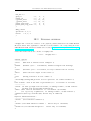
ESA/CNES contracts “Mars Environment Models” WP11.1 Deliverable Report Ref: ESA 11369/95/NL/JG(SC) CNES “Base de données atmosphériques martiennes” [DRAFT] User Manual for the LMD Martian Mesoscale Model A. Spiga Laboratoire de Météorologie Dynamique Institut Pierre Simon Laplace Université Pierre et Marie Curie Paris, France Contact: [email protected], [email protected] December 13, 2008 Contents I Introducing the model 1 II First steps toward running the model II.1 Prerequisites . . . . . . . . . . . . . . . . . . II.1.1 General requirements . . . . . . . . . II.1.2 Parallel computations . . . . . . . . . II.1.3 Compiling the terrestrial WRF model II.2 Compiling the Martian model . . . . . . . . . II.2.1 Extracting and preparing the sources . II.2.2 Main compilation step . . . . . . . . . II.3 Running a simple test case . . . . . . . . . . . . . . . . . . . 3 3 3 4 4 5 5 6 7 III Setting the simulation parameters III.1 Dynamical settings . . . . . . . . . . . . . . . . . . . . . . . . . . . . . . . . . . . . III.2 Physical settings . . . . . . . . . . . . . . . . . . . . . . . . . . . . . . . . . . . . . 9 9 13 IV Preprocessing utilities IV.1 Installing the preprocessing utilities . . . . . . . . . . . . . . . . . IV.2 Running the preprocessing utilities . . . . . . . . . . . . . . . . . IV.2.1 Input data . . . . . . . . . . . . . . . . . . . . . . . . . . IV.2.1.1 Static data . . . . . . . . . . . . . . . . . . . . . IV.2.1.2 Meteorological data . . . . . . . . . . . . . . . . IV.2.2 Preprocessing steps . . . . . . . . . . . . . . . . . . . . . . IV.2.2.1 Step 1: Converting GCM data . . . . . . . . . . IV.2.2.2 2: Interpolation on the regional domain . . . . . IV.2.2.3 Step 3: Vertical interpolation on mesoscale levels . . . . . . . . . 17 17 18 18 18 20 21 21 21 23 V Starting simulations from scratch V.1 Running your own GCM simulations . . . . . . . . . . . . . . . . . . . . . . . . . . V.2 Complete simulations with runmeso . . . . . . . . . . . . . . . . . . . . . . . . . . 25 25 25 VI Outputs VI.1 Postprocessing utilities and graphics . . . . . . . . . . . . . . . . . . . . . . . . . . VI.2 Modify the outputs . . . . . . . . . . . . . . . . . . . . . . . . . . . . . . . . . . . . 27 27 27 VIIFrequently Asked Questions 29 iii . . . . . . . . . . . . . . . . . . . . . . . . . . . . . . . . . . . . . . . . . . . . . . . . . . . . . . . . . . . . . . . . . . . . . . . . . . . . . . . . . . . . . . . . . . . . . . . . . . . . . . . . . . . . . . . . . . . . . . . . . . . . . . . . . . . . . . . . . . . . . . . . . . . . . . . . . . . . . . . . . . . . . . . . . . . . . . . . . . . . . . . . . . . . . . . . . . . . . . . . . . . . . . . . . . . . . . . . . . . . . . . . . . . . . . . . . . . . . . . . . Chapter I Introducing the model + Please first read the document “Design and Performance of the LMD Martian Mesoscale Model” to know what the model is, what kind of results can be obtained and how these results compare with available data or independant simulations To be completed with description of the dynamics/physics driver 1 2 User Manual for the LMD Martian Mesoscale Model Chapter II First steps toward running the model This chapter is meant for first time users of the LMD Martian Mesoscale Model. We describe how to install the model on your system, compile the program and run a test case. Experience with either the terrestrial WRF mesoscale model or the LMD Martian GCM is not absolutely required, although it would help you getting more easily through the installation process. II.1 II.1.1 Prerequisites General requirements In order to install the LMD Martian Mesoscale Model, please ensure that: ◦ ◦ ◦ ◦ ◦ ◦ your computer is connected to the internet; your OS is Linux1 with a decent set of basic commmands (sed, awk, . . . ); your Fortran compiler is the PGI commercial compiler pgf90 or the GNU free compiler2 g95; your C compiler is gcc and C development libraries are included; bash, m4 and perl are installed on your computer; NETCDF libraries have been compiled on your system. + You might also find useful – though not mandatory – to install on your system: ◦ the ncview utility3 , which is a nice tool to visualize the contents of a NETCDF file; ◦ the IDL demo version4 , which is used by the plot utilities provided with the model. Three environment variables associated with the NETCDF libraries must be defined: declare -x NETCDF=/disk/user/netcdf declare -x NCDFLIB=$NETCDF/lib declare -x NCDFINC=$NETCDF/inc + All command lines in the document are proposed in bash. You also need the environment variable $LMDMOD to point at the directory where you will install the model (e.g. /disk/user/MODELS): declare -x LMDMOD=/disk/user/MODELS + Please check that ∼ 200 Mo free disk space is available in /disk. 1 2 3 4 The model was also successfully compiled on MacOSX; “howto” information is available upon request. Sources and binaries available on http://www.g95.org http://meteora.ucsd.edu/~pierce/ncview_home_page.html http://www.ittvis.com/ProductServices/IDL.aspx 3 4 User Manual for the LMD Martian Mesoscale Model II.1.2 Parallel computations Parallel computations with the Message Passing Interface (MPI) standard are supported by the ARW-WRF mesoscale model. If you want to use this capability in the LMD Martian Mesoscale Model, you would have the installation of MPICH2 as a additional prerequisite. Please download the current stable version of the sources (e.g. mpich2-1.0.8.tar.gz) on the MPICH2 website http://www.mcs.anl.gov/research/projects/mpich2 and install the MPICH2 utilities by the following commands: mkdir $LMDMOD/MPI mv mpich2-1.0.8.tar.gz $LMDMOD/MPI cd $LMDMOD/MPI tar xzvf mpich2-1.0.8.tar.gz cd mpich2-1.0.8 ./configure --prefix=$PWD --with-device=ch3:nemesis > conf.log 2> conferr.log & # please wait... make > mk.log 2> mkerr.log & declare -x WHERE_MPI=$LMDMOD/MPI/mpich2-1.0.8/bin + Even if you add the $LMDMOD/MPI/mpich2-1.0.8/bin directory to your $PATH variable, defining the environment variable $WHERE MPI is still required to ensure a successful compilation of the model. II.1.3 Compiling the terrestrial WRF model The LMD Martian Mesoscale Model is based on the terrestrial NCEP/NCAR ARW-WRF Mesoscale Model. As a first step towards the compilation of the Martian version, we advise you to check that the terrestrial model compiles on your computer with either g95 or pgf90. On the ARW-WRF website http://www.mmm.ucar.edu/wrf/users/download/get_source.html, you will be allowed to freely download the model after a quick registration process (click on “New users”). Make sure to download the version 2.2 of the WRF model and copy the WRFV2.2.TAR.gz archive to the $LMDMOD folder. Then please extract the model sources and configure the compilation process: cd $LMDMOD tar xzvf WRFV2.2.TAR.gz cd WRFV2 ./configure The configure script analyzes your architecture and proposes you several possible compilation options. Make sure to choose the “single-threaded, no nesting” option related to either g95 (should be option 13 on a 32 bits Linux PC) or pgf90 (should be option 1 on a 32 bits Linux PC). The next step is to compile the WRF model by choosing the kind of simulations you would like to run. A simple and direct test consists in trying to compile the idealized case of a 2D flow impinging on a small hill: ./compile em_hill2d_x > log_compile 2> log_error & + In case you encounter problems compiling the ARW-WRF model, please read documentation on the website http://www.mmm.ucar.edu/wrf/users, contact the WRF helpdesk or search the web for your error message. User Manual for the LMD Martian Mesoscale Model 5 If the compilation was successful (the file log error should be empty or only reporting few warnings), you should find in the main folder two executables ideal.exe and run.exe that would allow you to run the test simulation: cd test/em_hill2d_x ./ideal.exe ./wrf.exe During the simulation, the time taken by the computer to perform integrations at each dynamical timestep is displayed in the standard output. The simulation should end with a message SUCCESS COMPLETE WRF. The model results are stored in a wrfout data file you might like to browse with a NETCDF-compliant software such as ncview. + If you compiled the model with g95, ideal.exe will probably complain about an error reading the namelist. Please move the line non hydrostatic below the line v sca adv order in the namelist.input file to solve the problem. II.2 II.2.1 Compiling the Martian model Extracting and preparing the sources To start the installation of the Martian mesoscale model, download the archive LMD MM MARS.tar.gz (click on http://www.lmd.jussieu.fr/~aslmd/LMD_MM_MARS/LMD_MM_MARS.tar.gz or use the wget command). Copy the sources in the $LMDMOD directory and extract the files: cp LMD_MM_MARS.tar.gz $LMDMOD cd $LMDMOD tar xzvf LMD_MM_MARS.tar.gz Execute the prepare script that would do some necessary preparatory tasks for you: deflate the various compressed archives contained into LMD MM MARS, download the ARW-WRF sources from the web, apply a (quite significant) “Martian patch” to these sources and build the final structure of your LMD MM MARS directory: cd $LMDMOD/LMD_MM_MARS ./prepare Please check the contents of the LMD MM MARS directory: ◦ seven bash scripts: build static, copy model, makemeso, prepare, prepare ini, prepare post, save all; ◦ the sources directory SRC; ◦ the static data directory WPS GEOG; ◦ the simulation utilities directory SIMU. and check that the LMD MM MARS/SRC directory contains: ◦ ◦ ◦ ◦ the model main sources in WRFV2, the preprocessing sources in WPS and PREP MARS, the postprocessing sources in ARWpost, three tar.gz archives and two information text files. 6 User Manual for the LMD Martian Mesoscale Model II.2.2 Main compilation step In order to compile the model, execute the makemeso compilation script in the LMD MM MARS directory cd $LMDMOD/LMD_MM_MARS ./makemeso and answer to the questions about 1. compiler choice (and number of processors if using MPI) 2. number of grid points in longitude [61] 3. number of grid points in latitude [61] 4. number of vertical levels [61] 5. number of tracers [1] 6. number of domains [1] + On the first time you compile the model, you will probably wonder what to reply to questions 2 to 6 . . . type the answers given in brackets to compile an executable suitable for the test case given below. + Suppose you compiled a version of the model for a given set of parameters 1 to 6 to run a specific compilation. If you would like to run another simulation with at least one of parameters 1 to 6 subject to change, the model needs to be recompiled5 with makemeso. + When you use parallel computations, please bear in mind that with 2 (resp. 4, 6, 8, 16) processors the whole domain would be separated into 2 (resp. 2, 3, 4, 4) tiles over the latitude direction and 1 (resp. 2, 2, 2, 4) tile over the longitude direction. Thus make sure that the number of grid points minus 1 in each direction could be divided by the aforementioned number of tiles over the considered direction. + If you use grid nesting, note that no more than 4 processors can be used. The makemeso is an automated script which performs the following serie of tasks: ◦ determine if the machine is 32 or 64 bits; ◦ ask the user about the compilation settings; ◦ create a corresponding directory $LMDMOD/LMD MM MARS/DIRCOMP; + For example, a DIRCOMP directory named g95 32 single is created if the user requested a g95 compilation of the code for single-domain simulations on a 32bits machine. ◦ generate with copy model a directory DIRCOMP/WRFV2 containing links to SRC/WRFV2 sources; + This method ensures that any change to the model sources would be propagated to all the different DIRCOMP installation folders. ◦ ◦ ◦ ◦ execute the WRF configure script with the correct option; tweak the resulting configure.wrf file to include a link towards the Martian physics; calculate the total number of horizontal grid points handled by the LMD physics; duplicate LMD physical sources if nesting is activated; + The model presently supports 3 nests, but more nests can be included by adaptating the following files: $LMDMOD/LMD_MM_MARS/SRC/WRFV2/call_meso_inifis3.inc $LMDMOD/LMD_MM_MARS/SRC/WRFV2/call_meso_physiq3.inc $LMDMOD/LMD_MM_MARS/SRC/WRFV2/mars_lmd/libf/duplicate3 $LMDMOD/LMD_MM_MARS/SRC/WRFV2/mars_lmd/libf/generate3 $LMDMOD/LMD_MM_MARS/SRC/WRFV2/mars_lmd/makegcm* ## search for ’nest’ 5 This necessary recompilation each time the number of grid points, tracers and domains is modified is imposed by the LMD physics code. The WRF dynamical core alone is much more flexible. User Manual for the LMD Martian Mesoscale Model 7 ◦ compile the LMD physical packages with the appropriate makegcm command and collect the compiled objects in the library liblmd.a; + During this step that could be a bit long, especially if you defined more than one domain, the makemeso script provides you with the full path towards the text file log compile phys in which you can check for compilation progress and possible errors. In the end of the process, you will find an error message associated to the generation of the final executable. Please do not pay attention to this, as the compilation of the LMD sources is meant to generate a library of compiled objects called liblmd.a instead of a program. ◦ compile the modified Martian ARW-WRF solver, including the liblmd.a library; + When it is the first time the model is compiled, this step could be quite long. The makemeso script provides you with a log compile text file where the progress of the compilation can be checked and a log error text file listing errors and warnings during compilation. A list of warnings related to grib utilities (not used in the Martian model) may appear and have no impact on the final executables. + The compilation with g95 might be unsuccessful due to some problems with files related to terrestrial microphysics. Please type the following commands: cd $LMDMOD/LMD_MM_MARS/SRC tar xzvf g95.tar.gz cp -f g95/WRFV2_g95_fix/* WRFV2/phys/ cd $LMDMOD/LMD_MM_MARS then recompile the model with the makemeso command. ◦ change the name of the executables in agreements with the settings provided by the user. + If you choose to answer to the makemeso questions using the aforementioned parameters in brackets, you should have in the DIRCOMP directory two executables: real_x61_y61_z61_d1_t1_p1.exe wrf_x61_y61_z61_d1_t1_p1.exe The directory also contains a text file in which the answers to the questions are stored, which allows you to re-run the script without the “questions to the user” step: ./makemeso < makemeso_x61_y61_z61_d1_t1_p1 II.3 Running a simple test case We suppose that you had successfully compiled the model at the end of the previous section and you had used the answers in brackets to the makemeso questions. In order to test the compiled executables, a ready-to-use test case (with pre-generated initial and boundary conditions) is proposed in the LMD MM MARS TESTCASE.tar.gz archive you can download at http://www.lmd.jussieu.fr/~aslmd/LMD_MM_MARS/LMD_MM_MARS_TESTCASE.tar. gz. This test case simulates the hydrostatic atmospheric flow around Arsia Mons during half a sol with constant thermal inertia, albedo and dust opacity. + Though the simulation reproduces some reasonable features of the mesoscale circulation around Arsia Mons (e.g. slope winds), it should not be used for scientific purpose, for the number of grid points is unsufficient for single-domain simulation and the integration time is below the necessary spin-up time. 8 User Manual for the LMD Martian Mesoscale Model To launch the test simulation, please type the following commands, replacing the g95 32 single directory with its corresponding value on your system: cp LMD_MM_MARS_TESTCASE.tar.gz $LMDMOD/LMD_MM_MARS/ tar xzvf LMD_MM_MARS_TESTCASE.tar.gz cd TESTCASE ln -sf ../g95_32_single/real_x61_y61_z61_d1_t1_p1.exe wrf.exe tar xzvf wrfinput.tar.gz nohup wrf.exe > log_wrf & + If you compiled the model using MPICH2, the command to launch a simulation is slightly different: [simulation on 2 processors on 1 machine] mpd & # first-time only (or after a reboot) # NB: may request the creation of a file .mpd.conf mpirun -np 8 wrf.exe < /dev/null & # NB: mpirun is only a link to mpiexec tail -20 rsl.out.000? # to check the outputs [simulation on 16 processors in 4 connected machines] echo barry.lmd.jussieu.fr > ~/mpd.hosts echo white.lmd.jussieu.fr >> ~/mpd.hosts echo loves.lmd.jussieu.fr >> ~/mpd.hosts echo tapas.lmd.jussieu.fr >> ~/mpd.hosts ssh barry.lmd.jussieu.fr # make sure that ssh to other machines # is possible without authentification mpdboot -f ~/mpd.hosts -n 4 mpdtrace mpirun -l -np 16 wrf.exe < /dev/null & # NB: mpirun is only a link to mpiexec tail -20 rsl.out.00?? # to check the outputs Chapter III Setting the simulation parameters In this chapter, we describe how to set the various parameters defining a given simulation. As could be inferred from the content of the TESTCASE directory, two parameter files are needed to run the model: 1. The parameters related to the dynamical part of the model can be set in the file namelist.input according to the ARW-WRF namelist formatting. 2. The parameters related to the physical part of the model can be set in the file callphys.def according to the LMD-MGCM formatting. III.1 Dynamical settings namelist.input controls the behavior of the dynamical core in the LMD Martian Mesoscale Model. Compared to the file the ARW-WRF users are familiar with1 , the namelist.input in the LMD Martian Mesoscale Model is much shorter. The only mandatory parameters in this file are information on time control2 and domain definition. The minimal version of the namelist.input file corresponds to standard simulations with the model. It is however possible to modify optional parameters if needed, as is the case in the namelist.input associated to the Arsia Mons test case (e.g. the parameter non hydrostatic is set to false to assume hydrostatic equilibrium, whereas standard simulations are non-hydrostatic). A detailed description of the namelist.input file is given below3 . Comments on each of the parameters are provided, with the following labels: ◦ ◦ ◦ ◦ (*) denotes parameters not to be modified, (r) indicates parameters which modification implies a new recompilation of the model, (n) describes parameters involved when nested domains are defined, (p1), (p2), (p3) mention parameters which modification implies a new processing of initial and boundary conditions (see next chapter), ◦ (*d) denotes dynamical parameters which modification implies non-standard simulations – please read SRC/WRFV2/run/README.namelist and use with caution. If omitted, the optional parameters would be set to their default values indicated below. 1 A description of this file can be found in SRC/WRFV2/run/README.namelist. More information on the adopted Martian calendar: http://www-mars.lmd.jussieu.fr/mars/time/solar_ longitude.html 3 You may find the corresponding file in SIMU/namelist.input full. 2 9 10 User Manual for the LMD Martian Mesoscale Model -- file: &time_control start_year = 2024, start_month = 07, start_day = 01, start_hour = 06, end_year = 2024, end_month = 07, end_day = 02, end_hour = 06, history_interval = 37, frames_per_outfile = 24, restart = .false. restart_interval = 8880 io_form_history = 2 io_form_restart = 2 io_form_input = 2 io_form_boundary = 2 debug_level = 0 !! !! OPTIONAL !! interval_seconds = 3700 input_from_file = T, / &domains time_step = 50 dx = 20000, dy = 20000, e_we = 51, e_sn = 51, e_vert = 61, p_top_requested = 5 !! !! OPTIONAL !! time_step_fract_num = 0 time_step_fract_den = 1 num_metgrid_levels = 26 force_sfc_in_vinterp = 8 max_dz = 1500. eta_levels = -1. max_dom = 1 grid_id parent_id i_parent_start j_parent_start parent_grid_ratio parent_time_step_ratio / = = = = = = 1, 0, 0, 0, 1, 1, !! !! !! !! !! !! !! !! !! !! !! !! !! !! !! !! !! namelist.input full -- (p1) Start Martian Year (20XX for MY XX) (p1) Start Martian Month (p1) Start Martian Day (p1) Start Martian Hour (at longitude 0) (p1) End Martian Year (20XX for MY XX) (p1) End Martian Month (p1) End Martian Day (p1) End Martian Hour (at longitude 0) Frequency of outputs (37 --> 3700s = 1 Martian hour) Size of time dimension in files (*) Output restart files ? (*) Frequency of output restart files ? (*) Choice of NETCDF for ouputs (*) Choice of NETCDF for ouputs (*) Choice of NETCDF for ouputs (*) Choice of NETCDF for ouputs (*) Verbose level !! (p2) Frequency of large-scale fields update (s) !! (n)(p2) Initialize a given domain with an input file !! !! !! !! !! !! !! Dynamical timestep (p2) Horizontal resolution (p2) Horizontal resolution (should be equal to dx) (r)(p2) Number of longitude grid points (r)(p2) Number of latitude grid points (r)(p2) Number of vertical levels (p3) Chosen value of pressure at the top of the model !! !! !! !! !! !! !! !! !! !! !! !! !! !! Additional fraction to time_step: numerator Additional fraction to time_step: denominator (p1) number of vertical levels in GCM inputs (+1) (p3) Number of levels hardwired in the PBL NB: decrease this parameter when low model top (p3) Maximal interval (m) between vertical levels (p3) Specify a list of e_vert eta levels (r)(n)(p2) Total number of domains (n)(p2) Identification of the domain (n)(p2) Associated parent domain (n)(p2) x-position of the bottom-left nest corner (n)(p2) x-position of the bottom-left nest corner (n)(p2) Ratio of horizontal resolution parent/nest (n) Ratio of time step parent/nest User Manual for the LMD Martian Mesoscale Model &physics !! !! OPTIONAL !! radt = 1, mars = 0, init_TI = 0., init_AL = 0., init_U = 0., init_V = 0., init_WX = 0., init_WY = 0., init_MU = 0., init_MV = 0., init_LES = F, / &dynamics !! !! OPTIONAL !! time_step_sound = 6, non_hydrostatic = T, pd_scalar = F, !! diff_opt = 1 km_opt = 4 diff_6th_factor = 2, diff_6th_opt = 0.2, smdiv = 0.1, emdiv = 0.01, epssm = 0.1, h_mom_adv_order = 5, v_mom_adv_order = 3, h_sca_adv_order = 5, v_sca_adv_order = 3, / &bdy_control !! !! OPTIONAL !! specified = T, nested = F, periodic_x = F, periodic_y = F, open_xs = F, open_xe = F, open_ys = F, open_ye = F, spec_bdy_width = 5 relax_zone = 4 / !! !! !! !! !! !! !! !! !! !! !! !! 11 Ratio between physical and dynamical time step (r)(p2) Configuration of tracers: 0: no tracers, 1: water vapor + ice, 2: dust (p3) Define constant thermal inertia value (p3) Define constant albedo value (p3) Define constant ini/bdy zonal wind value (p3) Define constant ini/bdy meridional wind value (p3) \ Ini/bdy wind profile is everywhere equal to (p3) / the wind profile @ grid pt (init_WX,init_WY) (p3) Multiply ini & bdy zonal wind by init_U (p3) Multiply ini & bdy meridional wind by init_V (p3) Uniform domain initialization for LES !! Ratio of time step dynamic/acoustic integration !! NB: an increase could help solve instabilities !! Integrate in non-hydrostatic/hydrostatic mode !! Positive-definite advection scheme for tracers !! !! !! !! !! !! !! !! !! !! !! (*d) (*d) (*d) (*d) (*d) (*d) (*d) (*d) (*d) (*d) (*d) Diffusion option [set to 0 if LES or GCM] Eddy coefficient option Knievel numerical diffusion [set to 0 if LES] Knievel numerical coeff. [set to 0.5 if GCM] Divergence damping External-mode filter for mass coord. model Time off-centering for vertical sound waves Horizontal momentum advection order Vertical momentum advection order Horizontal scalar advection order Vertical scalar advection order !! !! !! !! !! !! !! !! !! !! !! (n)(p3) Boundary conditions specified by GCM (n)(p3) Boundary conditions from parent domain (p3) Periodic boundary conditions over x (p3) Periodic boundary conditions over y (p3) Open boundary conditions @ western boundary (p3) Open boundary conditions @ eastern boundary (p3) Open boundary conditions @ southern boundary (p3) Open boundary conditions @ northern boundary (p3) Width of transition zone with specified=T NB: spec_bdy_width must equal relax_zone+1 (p3) Width of relaxation zone with specified=T 12 User Manual for the LMD Martian Mesoscale Model &grib2 / &fdda / &namelist_quilt nio_tasks_per_group = 0, nio_groups = 1, / !! !! !! !! (*) (*) (*) (*) -- end file: namelist.input full -- + Please pay attention to rigorous syntax while editing your personal namelist.input file to avoid reading error. + To modify the default values (or even add personal parameters) in the namelist.input file, edit the SRC/WRFV2/Registry/Registry.EM file. You will then have to recompile the model with makemeso ; answer y to the last question. In case you run simulations with max dom nested domains, you have to set max dom parameters wherever there is a “,” in the above list. Here is an example of the resulting syntax of the time control, domains and bdy control categories in namelist.input: &time_control start_year = start_month = start_day = start_hour = end_year = end_month = end_day = end_hour = history_interval frames_per_outfile restart = restart_interval = io_form_history = io_form_restart = io_form_input = io_form_boundary = debug_level = input_from_file = / 2024, 2024, 2024, 01, 01, 01, 49, 49, 49, 06, 06, 06, 2024, 2024, 2024, 01, 01, 01, 54, 54, 54, 06, 06, 06, = 74, 74, 74, = 12, 12, 12, .false. 8880, 2 2 2 2 0 T, T, T, &domains time_step = 40 dx = 36000, 9000, dy = 36000, 9000, e_we = 153, 157, e_sn = 153, 157, e_vert = 61, 61, p_top_requested = 3 2250, 2250, 157, 157, 61, User Manual for the LMD Martian Mesoscale Model max_dom = 3 grid_id parent_id i_parent_start j_parent_start parent_grid_ratio parent_time_step_ratio / = = = = = = 1, 0, 0, 0, 1, 1, 2, 1, 57, 57, 4, 2, 13 3, 2, 57, 57, 4, 2, &bdy_control specified = T, F, F nested = F, T, T / III.2 Physical settings callphys.def controls the behavior of the physical parameterizations in the LMD Martian Mesoscale Model. The organization of this file is exactly similar to the corresponding file in the LMD Martian GCM, which user manual can be found at http://web.lmd.jussieu.fr/~forget/ datagcm/user_manual.pdf. Please find in what follows the contents of callphys.def: -- file: callphys.def -- General options ~~~~~~~~~~~~~~~ tracer (Run with or without tracer transport ?) F diurnal (Diurnal cycle ? if diurnal=F, diurnal averaged solar heating) T season (Seasonal cycle ? if season=F, Ls stays constant like in "start") T lwrite (want some more output on the screen ?) F stats (Saving statistics in file "cumul" ?) F calleofdump (Saving EOF profiles in file "profiles" for Climate Database ?) F Dust scenario. Used if the dust is prescribed (i.e. if tracer=F or active=F) ~~~~~~~~~~~~~ iaervar (=1 Dust opt.deph read in startfi; =2 Viking scenario; =3 MGS scenario 4 (=4 Mars Year 24 from TES assimilation) iddist (Dust vertical distribution: =0: old distrib. (Pollack90) 3 (=1: top set by "topdustref"; =2: Viking scenario; =3 MGS scenario ) topdustref (Dust top altitude (km). Matter only if iddist=1) 55. Physical Parameterizations : ~~~~~~~~~~~~~~~~~~~~~~~~~~ callrad (call radiative transfer ?) T callnlte (call NLTE radiative schemes ? matter only if callrad=T) F callnirco2 (call CO2 NIR absorption ? matter only if callrad=T) T 14 User Manual for the LMD Martian Mesoscale Model calldifv (call turbulent vertical diffusion ?) T calladj (call convective adjustment ?) F callcond (call CO2 condensation ?) T callsoil (call thermal conduction in the soil ?) T calllott (call Lott’s gravity wave/subgrid topography scheme ?) F Radiative transfer options : ~~~~~~~~~~~~~~~~~~~~~~~~~~ iradia (the rad.transfer is computed every "iradia" physical timestep) 37 callg2d (Output of the exchange coefficient mattrix ? for diagnostic only) F rayleigh (Rayleigh scattering : should be =F for now) F Tracer (dust water, ice and/or chemical species) options (use if tracer=T) : ~~~~~~~~~~~~~~~~~~~~~~~~~~~~~~~~~~~~~~~~~~~~~~~~~~~~~~~~~~~~~~~~~~~~~~~~~~ dustbin (DUST: Transported dust ? (if >0, uses q(1) to q(dustbin)) 0 active (DUST: Radiatively active dust ? (uses q(1) to q(dustbin)) F doubleq (DUST: needs dustbin=1, use mass q(1) and nb q(2) mr to predict dust size ?) F lifting (DUST: lifted by GCM surface winds ?) F dustdevil (DUST: lifted by dust devils ?) F scavenging (DUST: Scavenging by CO2 snowfall ?) F sedimentation (DUST/WATERICE: Gravitationnal sedimentation ?) F iceparty (WATERICE: Water cycle includes water ice mixing ratio q(nqmx-1)) F activice (WATERICE: Radiatively active transported atmospheric water ice ?) F water (WATER: Compute water cycle using q(nqmx) ) F caps (WATER: put the current permanent caps at both poles) F photochem (PHOTOCHEMISTRY: chemical species included) F Thermospheric options (relevant if tracer=T) : ~~~~~~~~~~~~~~~~~~~~~~~~~~~~~~~~~~~~~~~~~~~~~~ callthermos (call thermosphere ?) F thermoswater (WATER: included without cycle only if water=F) F callconduct (call thermal conduction ? matter only if callthermos=T) F calleuv (call EUV heating ? matter only if callthermos=T) F callmolvis (call molecular viscosity ? matter only if callthermos=T) F User Manual for the LMD Martian Mesoscale Model 15 callmoldiff (call molecular diffusion ? matter only if callthermos=T) F thermochem (call thermospheric photochemistry ? matter only if callthermos=T) F solarcondate (date for solar flux calculation: 1985 < date < 2002)) 1993.4 (Solar min=1996.4 ave=1993.4 max=1990.6) -- end file: callphys.def -- + Note that in the given example the convective adjustment, the gravity wave parameterization, and the NLTE schemes are turned off, as is usually the case in typical Martian tropospheric mesoscale simulations. + iradia sets the frequency (in dynamical timesteps) at which the radiative computations are performed. + Modifying callphys.def only implies to recompile the model if the number of tracers is different. + If you run a simulation with, say, 3 domains, please ensure that you defined three files callphys.def, callphys d2.def and callphys d3.def. 16 User Manual for the LMD Martian Mesoscale Model Chapter IV Preprocessing utilities In the previous chapter, we decribed the simulation settings in the namelist.input file. We saw that any modification of the parameters labelled with (p1), (p2) or (p3) implies the initial and boundary conditions and/or the domain definition to be recomputed prior to running the model again. As a result, you were probably unable to change many of the parameters of the Arsia Mons test case (proposed in section II.3) in which the initial and boundary conditions – as well as the domain of simulation – were predefined. In this chapter, we describe the installation and use of the preprocessing tools to define the domain of simulation, calculate an initial atmospheric state and prepare the boundary conditions for the chosen simulation time. This necessary step would eventually allow you to run your own simulations at the specific season and region you are interested in, with a complete ability to modify any of the parameters in namelist.input. IV.1 Installing the preprocessing utilities First and foremost, since the preprocessing utilities could generate (or involve) files of quite significant sizes, it is necessary to define a directory where these files would be stored. Such a directory (e.g. /bigdisk/user) must be linked as follows ln -sf /bigdisk/user $LMDMOD/TMPDIR A second prerequisite to the installation of the preprocessing tools is that the LMD Martian Mesoscale Model was compiled at least once. If this is not the case, please compile the model with the makemeso command (see section II.2.2). The compilation process created an installation directory adapted to your particular choice of compiler+machine. The preprocessing tools will also be installed in this directory. Please type the following commands: cd $LMDMOD/LMD_MM_MARS/g95_32_single/ ln -sf ../prepare_ini . ./prepare_ini ## or any install directory The script prepare ini plays with the preprocessing tools an equivalent role as the copy model with the model sources : files are simply linked to their actual location in the SRC folder. Once you have executed prepare ini, please check that two folders were generated: PREP MARS and WPS. In the PREP MARS directory, please compile the programs create readmeteo.exe and readmeteo.exe, using the compiler mentionned in the name of the current installation directory: 17 18 User Manual for the LMD Martian Mesoscale Model echo $PWD cd PREP_MARS/ ./compile [or] ./compile_g95 ls -lt create_readmeteo.exe readmeteo.exe cd .. In the WPS directory, please compile the programs geogrid.exe and metgrid.exe: cd WPS/ ./configure ## select your compiler + ’NO GRIB2’ option ./compile ls -lt geogrid.exe metgrid.exe Apart from the executables you just compiled, the preprocessing utilities include real.exe, which was compiled by the makemeso script along with the mesoscale model executable wrf.exe. real.exe should be copied or linked in the simulation directory (e.g. TESTCASE for the Arsia Mons test case) to be at the same level than namelist.input. + Even though the name of the executable writes e.g. real x61 y61 z61 d1 t1 p1.exe, such program is not related to the specific makemeso parameters – contrary to the wrf.exe executable. We just found that renaming the (possibly similar if the model sources were not modified) real.exe was a practical way not to confuse between executables compiled at different moments. IV.2 Running the preprocessing utilities When you run a simulation with wrf.exe, the program attempts to read the initial state in the files wrfinput d01, wrfinput d02, . . . (one file per domain) and the parent domain boundary conditions in wrfbdy d01. The whole chain of data conversion and interpolation needed to generate those files is summarized in the diagram next page. Three distinct preprocessing steps are necessary to generate the final files. As is described in the previous section, some modifications in the namelist.input file [e.g. start/end dates labelled with (p1)] requires a complete reprocessing from step 1 to step 3 to successfully launch the simulation, whereas other changes [e.g. model top labelled with (p3)] only requires a quick reprocessing at step 3, keeping the files generated at the end of step 2 the same. IV.2.1 IV.2.1.1 Input data Static data All the static data (topography, thermal inertia, albedo) needed to initialize the model are included in the $LMDMOD/LMD MM MARS/WPS GEOG directory. By default, only coarse-resolution datasets1 are available, but the directory also contains sources and scripts to install finer resolution datasets: ◦ 32 and/or 64 pixel-per-degree (ppd) MOLA topography [Smith et al., 2001], ◦ 8 ppd MGS/Thermal Emission Spectrometer (TES) albedo [Christensen et al., 2001], ◦ 20 ppd TES thermal inertia [Putzig and Mellon, 2007] 1 Corresponding to the fields stored in the file surface.nc known by LMD-MGCM users: http://web.lmd. jussieu.fr/~forget/datagcm/datafile/surface.nc Preprocessing Step 1 Preprocessing Step 2a input_diagfi.nc WPS_GEOG > time series of winds, temperature, tracers > global domain > GCM vertical levels > topography, thermal inertia, albedo > global domain create_readmeteo.exe readmeteo.exe geogrid.exe LMD:20240701_06:00:00 geo_em.d01.nc > winds, temperature, tracers at a given date > global domain > GCM vertical levels > topography, thermal inertia, albedo > regional projected domain Preprocessing Step 2b metgrid.exe met_em.d01.20240701_06:00:00.nc > topography, thermal inertia, albedo > winds, temperature, tracers at a given date > regional projected domain > GCM vertical levels Preprocessing Step 3 real.exe wrfbdy_d01 > topography, thermal inertia, albedo > winds, temperature, tracers at all simulation steps > boundaries only > mesoscale vertical levels wrfinput_d01 > topography, thermal inertia, albedo > winds, temperature, tracers at starting time > regional projected domain > mesoscale vertical levels 20 User Manual for the LMD Martian Mesoscale Model The role of the build static script is to automatically download these datasets from the web (namely PDS archives) and convert them to an acceptable format for a future use by the preprocessing utilities: cd $LMDMOD/LMD_MM_MARS ./build_static + Please install the octave free software2 on your system to be able to use the build static script. Another solution is to browse into each of the directories contained within WPS GEOG, download the data with the shell scripts and execute the .m scripts with either octave or the commercial software matlab (just replace # by %). + If you do not manage to execute the build static script, converted ready-to-use datafiles are available upon request. + The building of the MOLA 64ppd topographical database can be quite long. Thus, such a process is not performed by default by the build static script. If the user would like to build this database, please remove the exit command in the script, just above the commands related to the MOLA 64ppd. + The resulting WPS GEOG can reach a size of several hundreds of Mo. You might move such a folder in a place with more disk space available, but then be sure to create in $LMDMOD/LMD MM MARS a link to the new location of the directory. IV.2.1.2 Meteorological data The preprocessing tools generate initial and boundary conditions from the diagfi.nc outputs of LMD-MGCM simulations. If you would like to run a mesoscale simulation at a given season, you need to first run a GCM simulation and output the meteorological fields at the considered season. For optimal forcing at the boundaries, we advise you to write the meteorological fields to the diagfi.nc file at least each two hours. Please also make sure that the following fields are stored in the NETCDF diagfi.nc file: netcdf diagfi { dimensions: Time = UNLIMITED ; // (72 currently) index = 100 ; latitude = 49 ; longitude = 65 ; altitude = 32 ; variables: float Time(Time) ; Time:long_name = "Time" ; Time:units = "days since 0000-00-0 00:00:00" ; float controle(index) ; controle:title = "Control parameters" ; float latitude(latitude) ; latitude:units = "degrees_north" ; latitude:long_name = "North latitude" ; float longitude(longitude) ; longitude:long_name = "East longitude" ; longitude:units = "degrees_east" ; float aps(altitude) ; aps:title = "hybrid pressure at midlayers" ; aps:units = "Pa" ; float bps(altitude) ; bps:title = "hybrid sigma at midlayers" ; bps:units = "" ; 2 Available at http://www.gnu.org/software/octave User Manual for the LMD Martian Mesoscale Model 21 float phisinit(latitude, longitude) ; phisinit:title = "Geopotential at the surface" ; float emis(Time, latitude, longitude) ; emis:title = "Surface emissivity" ; emis:units = "w.m-1" ; float tsurf(Time, latitude, longitude) ; tsurf:title = "Surface temperature" ; tsurf:units = "K" ; float ps(Time, latitude, longitude) ; ps:title = "surface pressure" ; ps:units = "K" ; float co2ice(Time, latitude, longitude) ; co2ice:title = "co2 ice thickness" ; co2ice:units = "kg.m-2" ; float temp(Time, altitude, latitude, longitude) ; temp:title = "temperature" ; temp:units = "K" ; float u(Time, altitude, latitude, longitude) ; u:title = "Zonal wind" ; u:units = "m.s-1" ; float v(Time, altitude, latitude, longitude) ; v:title = "Meridional wind" ; v:units = "m.s-1" ; float tsoil(Time, altitude, latitude, longitude) ; tsoil:title = "soil temperature" ; tsoil:units = "K" ; float q01(Time, altitude, latitude, longitude) ; q01:title = "ice" ; q01:units = "kg/kg" ; float q02(Time, altitude, latitude, longitude) ; q02:title = "h2o" ; q02:units = "kg/kg" ; + If the fields emis, co2ice, q01, q02, tsoil are missing in the diagfi.nc file, they are replaced by respective default values 0.95, 0, 0, 0, tsurf. An example of input meteorological file diagfi.nc file can be downloaded at http://web.lmd. jussieu.fr/~aslmd/LMD_MM_MARS/diagfi.nc.tar.gz. Please deflate the archive and copy the diagfi.nc file in $LMDMOD/TMPDIR/GCMINI. Such a file can then be used to define the initial and boundary conditions, and we will go through the three preprocessing steps. IV.2.2 IV.2.2.1 Preprocessing steps Step 1: Converting GCM data The programs in the PREP MARS directory convert the data from the NETCDF diagfi.nc file into separated binary datafiles for each date contained in diagfi.nc, according to the formatting needed by the preprocessing programs at step 2. These programs can be executed by the following commands: cd $LMDMOD/LMD_MM_MARS/your_install_dir/PREP\_MARS echo 1 | ./create_readmeteo.exe # drop the "echo 1 |" if you want control ./readmeteo.exe < readmeteo.def If every went well with the conversion, the directory $LMDMOD/TMPDIR/WPSFEED should contain files named LMD:. IV.2.2.2 2: Interpolation on the regional domain In the WPS directory, the geogrid.exe program allows you to define the mesoscale simulation domain to horizontally interpolate the topography, thermal inertia and albedo fields at the domain resolution and to calculate useful fields such as topographical slopes. 22 User Manual for the LMD Martian Mesoscale Model Please execute the commands: cd $LMDMOD/LMD_MM_MARS/your_install_dir/WPS ln -sf ../../TESTCASE/namelist.wps . # test case ./geogrid.exe The result of geogrid.exe – and thus the definition of the mesoscale domain – can be checked in the NETCDF file geo em.d01.nc. A quick check can be performed using the command line ncview geo_em.d01.nc if ncview is installed, or the IDL script out geo.pro idl IDL> IDL> IDL> IDL> IDL> out_geo, field1=’TOPO’ out_geo, field1=’TI’ SPAWN, ’ghostview geo_em.d01_HGT_M.ps &’ SPAWN, ’ghostview geo_em.d01_THERMAL_INERTIA.ps &’ exit if the demo version of IDL is installed. Of course if your favorite graphical tool supports the NETCDF standard, you might use it to check the domain definition in geo em.d01.nc. If you are unhappy with the results or you want to change the location of the mesoscale domain on the planet, the horizontal resolution, the number of grid points . . . , please modify the parameter file namelist.wps and execute again geogrid.exe. Here are the contents of namelist.wps: &share wrf_core = ’ARW’, max_dom = 1, start_date = ’2024-01-04_02:00:00’ end_date = ’2024-01-04_12:00:00’ interval_seconds = 3700 io_form_geogrid = 2, debug_level = 0, opt_output_from_geogrid_path=’./’ / &geogrid parent_id parent_grid_ratio i_parent_start j_parent_start e_we e_sn geog_data_res = 1, = 1, = 1, = 1, = 61, = 61, = ’gcm’ dx = 20000, dy = 20000, map_proj = ’mercator’, ref_lat = -12., ref_lon = 239., truelat1 = 0.0, truelat2 = 0.0, stand_lon = 0.0, geog_data_path = ’./WPS_GEOG’, / !! !! !! !! !! !! !! !! [do not modify: choice of dynamical core] number of simulation domains YYYY-MM-DD_HH:mm:ss start date YYYY-MM-DD_HH:mm:ss end date frequency of GCM updates [1 Mars hour = 3700 s] [do not modify: choice of NETCDF outputs] verbose level of the programs location of the geogrid outputs !! number identifying the related parent domain !! ratio between parent and nested domains !! x-position of the southwest corner of nest !! y-position of the southwest corner of nest !! number of longitude grid points !! number of latitude grid points !! choice of static data sources !! NB: possible: ’64ppd’, ’32ppd’, ... !! NB: please glance at geogrid/GEOGRID.TBL !! resolution (meters) in the x-dimension !! resolution (meters) in the y-dimension !! map projection: ’mercator’, ’lambert’ or ’polar’ !! north latitude of the center of the domain !! east longitude of the center of the domain !! (lambert or polar) lat position of projection cone !! [do not modify] !! (lambert or polar) lon position of projection cone !! [do not modify: symbolic link in the WPS folder] User Manual for the LMD Martian Mesoscale Model 23 &metgrid fg_name = ’./WPSFEED/LMD’ !! [do not modify: symbolic link in the WPS folder] io_form_metgrid = 2, !! [do not modify: choice of NETCDF outputs] opt_output_from_metgrid_path=’./WRFFEED/current’ !! [do not modify: symbolic link] / + No input meteorological data are actually needed to execute geogrid.exe. + More details about the database and more options of interpolation could be found in the file geogrid/GEOGRID.TBL. + Defining several domains yields distinct files geo em.d01.nc, geo em.d02.nc, geo em.d03.nc. . . Once the geo em file(s) are generated, the metgrid.exe program performs a similar horizontal interpolation of the meteorological fields to the mesoscale domain as the one performed by geogrid.exe for the surface data. Then the program writes the results in met em files and also collects the static fields and domain parameters included in the geo em file(s) Please type the following commands: cd $LMDMOD/LMD_MM_MARS/your_install_dir/WPS ./metgrid.exe If every went well, the directory $LMDMOD/TMPDIR/WRFFEED should contain the met em.* files. IV.2.2.3 Step 3: Vertical interpolation on mesoscale levels The last step is to execute real.exe to perform the interpolation from the vertical levels of the GCM to the vertical levels defined in the mesoscale model. This program also prepares the final initial state for the simulation in files called wrfinput and the boundary conditions in files called wrfbdy. To successfully execute real.exe, you need the met em.* files and the namelist.input file to be in the same directory as real.exe. Parameters in namelist.input controlling the behavior of the vertical interpolation are those labelled with (p3) in the detailed list introduced in the previous chapter. Please type the following commands to prepare files for the Arsia Mons test case (or your personal test case if you changed the parameters in namelist.wps): cd $LMDMOD/TESTCASE ln -sf $LMDMOD/WRFFEED/met_em* . ./real.exe The final message of the real.exe should claim the success of the processes and you are now ready to launch the integrations of the LMD Martian Mesoscale Model again with the wrf.exe command as in section II.3. + When you modify either namelist.wps or namelist.input, make sure that the common parameters are exactly similar in both files (especially when running nested simulations) otherwise either real.exe or wrf.exe command will exit with an error message. 24 User Manual for the LMD Martian Mesoscale Model Chapter V Starting simulations from scratch V.1 Running your own GCM simulations To be completed V.2 Complete simulations with runmeso To be completed 25 26 User Manual for the LMD Martian Mesoscale Model Chapter VI Outputs VI.1 Postprocessing utilities and graphics To be completed. Do-it-all idl scripts would be described here ! VI.2 Modify the outputs To be completed. Though the method is different, we kept all the convenient aspects of writediagfi 27 28 User Manual for the LMD Martian Mesoscale Model Chapter VII Frequently Asked Questions + Which timestep should I choose to avoid crashes of the model ? + In the Martian simulations, why can’t I define boundaries each 6 hours as on Earth ? + Help ! I get strange assembler errors or ILM errors while compiling ! + Is it possible to run the model on a specific configuration that is not supported ? + Why do I have to define four less rows in the parent domain when performing nested runs ? + I am kind of nostalgic of early/middle Mars. How could I run mesoscale simulations at low/high obliquity ? + Why real.exe is crashing when the model top pressure is lower than 2 Pa ? + Can I use the two-way nesting ? To be completed. 29 30 User Manual for the LMD Martian Mesoscale Model


![LMD Martian Mesoscale Model [LMD-MMM] User Manual](http://vs1.manualzilla.com/store/data/006911548_1-e4280765449b25ef8991a0e08e28e935-150x150.png)