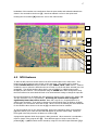
1
TNIP-SA
Transparent Noise Information Package
for Small Airports
User’s Manual
March 2004
Version 1.0
Preamble
TNIP-SA is a package of computer applications developed by the Australian Government
Department of Transport and Regional Services to facilitate the generation of aircraft noise
information for smaller airports. In the past these airports have not had ready access to such
information and there are no widely available tools for generating the type of information that is
now being sought by the operators of these airports.
TNIP-SA has been deliberately designed to provide a low cost route to aircraft noise
information. It is intended to be a tool to heighten awareness and knowledge about aircraft
noise and to provide a flag to indicate whether more detailed noise assessment work is
warranted. It is not designed to replace conventional noise models such as the widely used
Integrated Noise Model (INM). TNIP-SA takes the output of INM and presents it in a way that
gives a realistic ‘picture’ of noise around an airport.
Feedback Sought
As far as is known, the concepts used by TNIP-SA are new. Any feedback/comments on the
package would be welcome. Comments on the basic TNIP-SA concepts may be sent via email
to David Southgate at [email protected].
Technical/user queries can be directed to Donna Perera at [email protected]
Structure of the Manual
Part 1 – What TNIP-SA Can be Used For
This part briefly describes the types of applications that TNIP-SA can be used for. It provides
four example applications but these are not intended to be exhaustive – the package is likely to
be useful in any circumstances where a small airport is examining or discussing aircraft noise
issues.
Part 2 – Using TNIP-SA
This Part describes how the program can be used once it is set up.
The first section in this Part (Section 5) describes how the four TNIP-SA modules can be run
to let the user ‘see’ what is inside an airport’s noise contours and to produce aircraft noise
information.
The second section in this Part (Section 6) shows how a user can carry out rapid what-if
analyses. These let the user see the changes in noise exposure patterns that would be brought
about around an airport if the operations were changed in some way (eg if aircraft used
different runways or different aircraft types were used).
Extreme care needs to be carried out when using TNIP for what-if analyses. In order to
facilitate maximum flexibility the program allows the user to generate an extremely wide range
of operating scenarios for an airport. The program does not check whether or not these
are feasible. What-if analyses therefore ideally need to be carried out by a person who has a
detailed knowledge of the operating constraints of the airport being examined (eg which aircraft
types are capable of operating on which runways).
Part 3 – Limitations of the Output
It is strongly recommended that all TNIP-SA users read this Part of the Manual.
Experience has shown that all aircraft noise information has weaknesses and is open to
misinterpretation. When preparing information a balance has to be found between
completeness, accuracy, comprehensibility and timeliness. This Part of the Manual draws
attention to the limitations and potential sources of misinterpretation for each of the noise
descriptors.
Part 4 – Setting up TNIP-SA
This Part describes how to create the files that underpin the noise information and what-if
functions described in Part 2.
There are two distinct routes to the setting up of TNIP-SA.
TNIP-SA can be used in a generic mode that generates noise information based on a set of
general airport operating scenarios. This mode is intended to be used by those airports which
have not had an INM/ANEF study carried out. The TNIP-SA CD contains INM generated noise
grids for a number of runway length scenarios. The user selects one of these and then uses
the program to tailor the generic operating case to fit the specific operating circumstances of
the airport.
The second mode is intended to be used by those airports which have had an INM/ANEF study
carried out. In this mode TNIP-SA uses the data generated by the INM modeller to produce
noise information which is contained in the INM study but which has conventionally not be
accessible to the user.
1
Table of Contents
1.
1.1
1.2
1.3
INTRODUCTION
Background
Basic TNIP-SA concept
Required input
1.3.1 Airports without an ANEF
1.3.2 Airports with an ANEF
3
3
4
4
4
4
Part 1 – What TNIP-SA can be used for
2
2.1
2.2
2.3
2.4
3
3.1
3.2
3.3
3.4
3.5
EXAMPLE APPLICATIONS
Community Consultation/Involvement
Noise Disclosure
Land Use Planning
Tool for airport managers
THE TNIP-SA PRODUCTS/FUNCTIONS
Flight path data
ANEFs
Single event contours
Number Above contours (N70/N60 etc)
What-if analyses
7
7
7
8
8
9
9
9
9
12
12
Part 2 – Using TNIP-SA
4
4.1
4.2
4.3
4.4
5
5.1
5.2
GENERATING THE OUTPUT
INM Tracks Viewer
N70 Contours
Single Event Contours
ANEF and Other Metrics
WHAT-IF ANALYSES
Grid Editor
5.1.1 Simple Mode
5.1.2 Detailed Mode
5.1.3 General Features of the Grid Editor
5.1.4 Importing/Exporting Grids
Producing the What-if Contours
16
16
17
21
23
24
24
24
26
27
28
29
Part 3 – Limitations of the output
6
6.1
6.2
6.3
6.4
6.5
INTRODUCTION
Generic Noise Contours
N70 Contours
ANEF and Other Metrics
Tracks Viewer
What-if Scenarios
31
31
31
31
32
32
2
Part 4 – Setting up TNIP-SA
7
7.1
7.2
8
8.1
8.2
8.3
8.4
8.5
8.6
8.7
8.8
8.9
SETTING UP YOUR AIRPORT
Airports without an ANEF
Airports with an ANEF
34
34
35
SET UP FILES
36
Airport image
Airport configuration file
8.2.1 The Airport Configuration Editor
The tnc (TNIP Compressed) file
The tns (TNIP Compressed Summary) file
The tnf (TNIP Fast) file
The tng (TNIP Grid) file
The tnm (TNIP Multiplier) file
The tnt (TNIP Tracks) file
The Main Menu Thumbnails (the ‘Skin’ Files)
36
36
38
39
42
43
43
44
44
45
Part 5 – Appendix
9
9.1
9.2
INTRODUCTION
File Folder Structure
TNIP-SA file formats
9.2.1 The tnc (TNIP Compressed) File
9.2.2 The tnf (TNIP Fast) File
9.2.3 The tns (TNIP Compressed Summary) File
9.2.4 The tng (TNIP Grid) File
47
47
48
48
50
51
51
3
1.
Introduction
1.1 Background
Urban encroachment, and its associated aircraft noise pressures, is a growing concern for
smaller airports in Australia such as those serving regional centres. Representations on this
issue led to the Department releasing its Discussion Paper Going Beyond Noise Contours – Local
Approaches to Land Use Planning Around Smaller Australian Airports in October 2003.
In recent times the Department has made significant efforts to find better ways to describe
aircraft noise and to develop tools that will assist airports and their communities to
communicate with each other. In June 2003 the Department and Environment Australia jointly
published a document entitled Guidance material for selecting and providing aircraft noise
information. The consultation on this document revealed that there is a strong interest in
aircraft noise issues amongst the owners and operators of smaller airports. However, a major
constraint on taking this issue forward is the effective lack of access to aircraft noise
information for these airports. The Department has developed a small airport version of its
noise information software TNIP with a view to addressing this constraint. This version of TNIP
is called TNIP-SA.
In order to understand and analyse this issue an airport needs access to information on aircraft
noise exposure patterns in the vicinity of its premises. However, to date it has not been
practical to generate a great deal of useful noise information for smaller airports. The costs of
installing and operating a sophisticated Noise and Flight Path Monitoring System (NFPMS) at
these airports, similar to those in place at the major urban airports, would be prohibitive.
Irrespective of this, a conventional NFPMS would probably be of limited use at a small airport
where the sound pressure levels generated by most of the overflights are relatively low and
many of the aircraft may not be using radar transponders.
Airports with an ANEF
The US Federal Aviation Administration’s Integrated Noise Model (INM) has been used to
generate Australian Noise Exposure Forecast (ANEF) contours for many small airports in
Australia. Conventionally the ANEF contours have been the only output from the INM modelling
process that has been available to airports, land use planners and the public. However, the
files that are prepared for this modelling contain a significant amount of useful information
about the noise exposure patterns around an airport and TNIP-SA has been designed as a tool
to make this information accessible.
Using TNIP-SA, the flight tracks and operations assigned to the tracks in an INM study can be
easily viewed. Single event and number of noise events information can be generated in
addition to the ANEF information.
Airports without an ANEF
Many small airports have not carried out INM studies. TNIP-SA incorporates routines that
enable aircraft noise information to be generated for these airports without the need for specific
INM modelling to be carried out. The only airport specific input required to produce information
for these airports is some form of satellite image/aerial photograph/map on which to
superimpose the noise contours and flight tracks.
This part of TNIP-SA essentially assumes generic flight paths on the basis that operations at
smaller airports with no air traffic control will generally be based on standard arrival and
departure procedures. Once TNIP-SA has been set up for these airports it can produce noise
information using the same noise descriptors as those generated for the airports with an INM
study. However, since the information has been generated using generic flight paths it will
almost certainly be less robust than information derived from an INM study.
4
1.2 Basic TNIP-SA concept
TNIP-SA essentially has two modes as indicated in Section 1.1. One for airports for which an
INM study is available and the other which produces aircraft noise information on the basis of
generic operating conditions.
The mode for smaller airports which have an INM study differs from the full version of TNIP in
that it does not include the routines to produce flight path movements, respite and
measured N70 charts. These are not included in TNIP-SA since they are based on data
originating, either partially or fully, from Noise and Flight Path Monitoring Systems.
The TNIP-SA mode which generates noise information for airports without an INM study relies
on the fact that at smaller airports which do not have air traffic control, aircraft operate under
standard flight rules. These rules, in effect, result in similar flight track configurations existing
at most of these airports. Similarly the range of aircraft types/categories that operate at these
airports is similar (and also relatively limited). At a large number of the smaller airports the
movements take place on predominantly one runway. TNIP-SA uses these ‘standard’ conditions
to provide the user with a base case noise modelling scenario which can be modified to meet
the specific conditions at individual airports.
TNIP-SA contains an editor which allows the user to turn ‘on’ or ‘off’ selected aircraft types on
selected flight tracks and runways, and to set the numbers of movements on the tracks. This
allows the user to set the parameters to match those at the airport being examined and then to
generate the output products. In addition, it allows the user to carry out very rapid what-if
analyses.
It is very important to recognise that the output from TNIP-SA is only indicative, particularly for
the mode based on generic operating conditions. Separate detailed computer modelling will be
required if formal noise data (eg statutory land use planning noise contours) is to be produced.
1.3 Required input
To use TNIP-SA an image of the area surrounding the airport (with known coordinates of the
bottom left and top right corners of the image) is needed. This may be a satellite image, aerial
photograph or map which will need to be converted into a JPG file. It is possible to not have an
image and to superimpose the contour and flight track information on a plain background.
However, this is not the preferred approach as the noise information is likely to be of limited
value if it cannot be directly related to points on the ground.
1.3.1
Airports without an ANEF
Besides the image mentioned above, no other input is required. TNIP-SA contains files for a
generic airport that the user modifies to suit the particular airport being studied. This
modification in effect involves placing generic contours on the image and rotating these to align
with the runway. The aircraft types and movement numbers in the generic study are then
modified to match those applying at the actual airport. This process is described in Section 7
and 8.
In TNIP-SA v1.0 generic studies are provided for several different runway lengths but in this
version the program is only capable of generating noise information for airports with a single
runway. In later versions we plan to provide the capability to produce contours for airports
with multiple runways.
1.3.2
Airports with an ANEF
To use an existing ANEF study, the INM model has to be run to produce a detailed grid (DTL)
file for each of the required metrics (eg ANEF or LAMAX (for generating N70 [or N60 etc]
contours)). Once a DTL file has been created for a particular metric, no further INM runs are
5
required for that metric. These detailed grids are then processed in TNIP-SA to produce TNIP
input files which pack the data more compactly (file sizes are reduced by approximately 100
times). Various scenarios of aircraft operations at an airport can then be analysed by modifying
these TNIP input files within TNIP-SA.
6
Part 1
7
2
Example Applications
TNIP-SA can be used in a number of ways to assist the owners and operators of small airports
to manage aircraft noise issues. Essentially it is designed as a tool to facilitate greater
understanding of aircraft noise exposure patterns around these airports and to assist
communications between airports and their communities, and between airports and land use
planners, decision-makers, etc. Four examples of potential applications of TNIP-SA are given in
the following sub-sections.
2.1 Community Consultation/Involvement
One of the key strategies that emerged out of the consultation on the Department’s Going
Beyond Noise Contours – local approaches to land use planning around smaller Australian
airports was the need for the community to be involved in decisions on the future for its airport.
Aircraft noise is clearly one of the major potential negative impacts of an active airport. If an
informed community debate is to take place about the costs and benefits of future airport
development options it is essential that all interested parties are aware of the aircraft noise
exposure patterns likely to be generated by each of these options.
TNIP-SA can facilitate community involvement in these debates in a number of ways
·
It is an essentially ‘instant’ and interactive tool – it can be used in group meetings in
real-time to respond to questions/issues as they arise.
·
It generates information on aircraft noise that is readily understood – information based on
flight paths and numbers and loudness of individual events – this is significantly different to
using conventional land use planning (ANEF) contours to describe the noise patterns.
·
It describes noise patterns in areas well beyond the conventional land use planning
contours (which is very important at small airports where these contours often barely
extend beyond the airport boundaries).
·
It enables rapid ‘what-if’ analyses to be carried out – it is easy and fast to generate
different development scenarios and see the changes in the likely noise exposure patterns.
·
If ANEF contours are being used as the basis for land use planning controls, TNIP-SA can
be used to rapidly see the changes in the areas that would be subject to controls for
different development scenarios. This is likely to be of particular interest to holders of land
in the vicinity of the airport.
2.2 Noise Disclosure
Experience has shown that noise disclosure is a key strategy in managing aircraft noise and
potentially reducing community pressures on airports. In this context ‘noise disclosure’ means
providing information on aircraft noise exposure patterns, in a language that can be understood
by the non-expert, to
·
any person contemplating buying/moving into a house under or near an important flight
path
·
any person who may be living in an area that may be subject to new aircraft overflights.
This issue essentially revolves around avoiding ‘surprise noise’. For example, if people are
made aware of aircraft noise, and can factor it in to a housing decision, they are much less
likely to find the noise annoying than if they receive ‘surprise noise’ when they move into a new
home.
8
TNIP-SA can be used to produce high quality graphical images of aircraft noise exposure
patterns that can be provided to people either on an individual basis or through publication in
brochures, reports, etc.
2.3 Land Use Planning
It was indicated in Section 2.1 that developers and land holders in the vicinity of an airport are
likely to be very interested in the aircraft noise related land use planning controls which are
imposed on their property. There are other important aspects to this issue.
Conventionally, land use planners have treated areas outside ANEF contours as not being
affected by aircraft noise since under the ANEF system these areas are ‘acceptable’ for any type
of development with respect to aircraft noise. However, as discussed in the Going Beyond
Noise Contours discussion paper, at smaller airports the ANEF contours very often do not
extend far from an airport even though there may be very significant levels of aircraft overflight
in areas beyond the contours. This is particularly the case at airports with high levels of circuit
training activity. In essence this means that at some airports developments may be approved
under very active flight paths without the decision-maker being aware of the full picture.
Given the above, it is considered very important that land use planners, and the people making
land use planning decisions, are aware of aircraft noise outside the areas subject to formal land
use planning controls. TNIP-SA is a very good tool for making presentations to, or preferably
holding interactive sessions with, groups of people who are involved in land use planning
decisions.
The what-if functions in TNIP-SA are very useful as a tool to give land use planners a feel for
how the contours are constructed and how sensitive they are to change. For example, the
extent to which the ‘planning line’ may move as a result of uncertainty in operational forecasts
would ideally be factored into the thinking of the land use decision-maker.
2.4 Tool for airport managers
Airport managers and their staff, particularly at smaller airports, have traditionally had virtually
no information about the noise exposure patterns around their airports. At best they may have
had access to an ANEF contour map. However, as indicated earlier for many small airports
ANEF contours barely extend beyond the boundary of the airport. In addition experience has
shown that land use planning contours do not portray a very comprehensible, or
comprehensive, picture of noise around an airport.
TNIP-SA can assist airport managers and staff in a number of ways. It enables them to gain a
good picture of the noise exposure patterns around their airport and thus it enables them to
have more informed general discussions with the community or other interested parties about
aircraft noise. This knowledge is also likely to be useful when dealing with noise complainants.
At another level if an airport has commissioned an ANEF for land use planning purposes
TNIP-SA enables the airport manager to very clearly see how the contours have been
constructed and how many, and what types of, aircraft have been allocated to individual flight
paths. This provides an opportunity for a level of scrutiny of land use planning contours that
has not previously been available.
The what-if capabilities of TNIP-SA enable the airport manager to very rapidly gauge what the
changes would be to noise exposure patterns around the airport if various operational or
infrastructure changes were to be introduced.
9
3
The TNIP-SA Products/Functions
TNIP-SA enables new light to be thrown on aircraft noise exposure patterns in a number of
different ways. Firstly it can be used as a transparency tool to ‘see inside’ conventional noise
contours (ANEFs). This function enables the user to readily see both where the noise modeller
has located the flight paths and the type and number of aircraft that have been allocated to
each flight path. TNIP-SA allows the user to gain information on the loudness of individual
aircraft movements on each of the flight paths and also gives an overall picture of how many
‘loud’ noise events there are over a certain period. The what-if capabilities of the program
enable the user to gain a much greater understanding of how noise contours work and to see
for example the very big differences in the sensitivity to change of Number Above (N70)
contours compared to ANEF contours.
3.1 Flight path data
TNIP-SA allows the user to view the flight paths in an INM study. The example in Figure 3.1
shows all the flight paths that the INM modeller has included in the ANEF model for Mildura
Airport. The user is able to select any or all of the flight paths and see these displayed. The
program also tells the user how many and what type of aircraft have been allocated to each
flight path.
In practice flight paths do not correspond to single lines. There is normally a spread in the
flight paths and these typically form some form of flight path zone. The noise modeller
generally accounts for this by allocating aircraft movements to the core flight paths (the ‘spine
tracks’) and a number of sub-tracks in order to simulate the flight path zones.
3.2 ANEFs
Figure 3.2 shows the contours generated from the ANEF 2015 model for Mildura Airport.
TNIP-SA allows the user to very rapidly produce ANEF contours at levels other than the
conventional levels (eg maps showing 15 ANEF).
The contours produced by TNIP should only be treated as indicative. Formal land use planning
contours (ANEFs) should be generated through full runs of INM.
The program allows these contours to be superimposed on the flight path displays discussed in
Section 3.1.
3.3 Single event contours
Single event contours are useful to understand the relative loudness of different aircraft types
and to provide an indication of the extent to which an overflight may disturb an activity. For
example, an overflight of 70 dB(A) is likely to disturb conversation (telephone, watching TV,
etc) inside a house with open windows. However, for many of the aircraft operating at the
smaller airports noise disturbance is often related to very large numbers of overflights by
aircraft generating single event sound pressure levels of around 60 dB(A).
An example of a single event contour is shown in Figure 3.3. TNIP-SA allows the user to
generate single event contours for any aircraft type on any flight path that the modeller has
included in the original INM study. The user can select the contour noise intervals shown on
the output.
Figure 3.1 : All the tracks in the 2015 ANEF model for Mildura Airport. Green
is for departures, red for arrivals and blue for circuits.
10
11
Figure 3.2 : ANEF 2015 for Mildura Airport generated by TNIP-SA
Figure 3.3 : A single event contour for a BEC58P aircraft departing off
runway 27 at Mildura Airport along track D27M in the Mildura
ANEF 2015 model
12
Single event contours need to be examined in combination with number above contours
(N70, etc) contours so that an indication can be given, for any particular location, of the
number of events above a selected noise threshold in addition to how loud single events are.
3.4 Number Above contours (N70/N60 etc)
An example of an N70 noise contour map for Mildura Airport derived from its 2015 ANEF study
is shown in Figure 3.4.
Number Above contours in effect combine information about how loud individual events are
with how many times they occur. The contours provide information in a way that relates to
how a person experiences aircraft noise – as a series of separate noise events – and have
proven to give a ‘picture’ of the noise that can be visualised by a normal person.
TNIP-SA allows the user to select the threshold level for the Number Above. In Figure 3.5 it
can be seen that by selecting a threshold of 65 dB(A), rather than the 70 dB(A) shown in
Figure 3.4, a somewhat different picture emerges.
The program allows these contours to be superimposed on the flight path displays discussed in
Section 3.1.
3.5 What-if analyses
TNIP-SA has a function which lets the user change parameters within the model, such as the
number of movements on a particular flight path, and then to produce revised noise contours
within a period of a few seconds. This enables the user to very easily compare the noise
outcomes of various airport operating scenarios.
TNIP-SA allows the user to reproduce N70, ANEF and other INM metric contours after making
changes to an airport operation model. Examples of possible changes are increasing or
decreasing aircraft movements by a user selected %, 'turning off' a particular runway, flight
path or aircraft type and moving operations from one runway to another. These allow different
modes of operations to be investigated. More details are described in Section 5.
As an example, Figure 3.6 shows the ANEF contours that result from a doubling of all the
movements on all flight paths in the 2015 ANEF model for Mildura. These contours can be
compared to the original by reference to Figure 3.2.
13
Figure 3.4 : N70 contour for Mildura Airport based on the 2015 ANEF
Figure 3.5 : N65 contour for Mildura Airport based on the 2015 ANEF
14
Figure 3.6 : The ANEC produced by doubling the total number of movements
in the ANEF 2015 for Mildura Airport
15
Part 2
16
4
Generating the output
TNIP-SA has four main modules which are accessed from the main menu which is shown below.
The four
modules are
accessed by
using these
labels
The images that
appear in this
window can be
changed to
customise TNIP-SA
for an airport.
See Section 8.9.
4.1 INM Tracks Viewer
The INM Tracks Viewer enables the user to select and instantly display the tracks that the INM
modeller has used in computing the noise grids/contours. The Viewer is accessed from the
main menu by clicking the View INM Tracks button. An image of the Viewer is shown on the
next page.
To view the tracks click on the Open tns file button [1] and select a tns file from the directory
listing which appears. Once the tns file has been loaded, all spine tracks in the model are
shown on the map and data is added to the six drop-down list boxes on the right of the screen
which display the flights in terms of aircraft type, runway, operation type
(arrival/departure/circuit), stage length, tracks and subtracks.
Operations are selected by clicking on the items in the list boxes. Multiple selections (by
holding down the SHIFT key for contiguous selections and the CTRL key for non-contiguous
selections) are possible. The selected tracks are automatically shown on the map.
The 'busiest' tracks can also be selected by typing a number in the Show tracks with total
ops >= box [2] or selecting a number from its drop-down list. This feature allows only tracks
with total number of movements at or above the required value to be displayed. The Reset
button [3] returns the first six drop-down list boxes to their initial state which is to display all
the spine tracks in the model.
The labels on the tracks can be toggled on and off by using the Hide/Show Labels button [4].
Pressing the Save Map button [5] places a JPEG and bitmap image of the current flight track
map in the Output folder. Clicking on the Zoom buttons [6] and then clicking on the map
allows the user to zoom in and out. The image can be moved in any direction by holding the
mouse down and dragging on the image.
The number of movements allocated to each selected track is shown in the list box at [7].
Clicking an individual line (a single operation) in this list box will display the corresponding track
on the map. The total number of INM equivalent operations for all the selected tracks and the
17
breakdown of this number into contributions from the spine tracks and selected subtracks are
shown in the area above the box at [7]. Note that subtrack 0 refers to the spine track.
Pressing the Close button [8] returns the user to the main window.
1
2
3
8
6
4
5
7
4.2 N70 Contours
To start the N70 Contours module click on the N70 Contours label on the main menu. This
brings up the N70 Contours menu shown on the next page. This module can be used to
produce Number Above descriptors based on either LAMAX, TALA or SEL metrics. TNIP-SA
enables the user to select the desired noise cut-off level if a tnc file has been selected (see next
paragraph). The default Number Above level is set at 70 dB(A) for LAMAX contours and
80 dB(A) for SEL contours. We recommend using an LAMAX rather than TALA grid file since
the former allows the noise threshold level to be varied without having to change the input file.
First a noise grid has to be loaded into the program by clicking on the Choose File… button [1].
This file must have a tnc or tng extension. Producing the contours with a tng file is
significantly faster than with a tnc file. Note that a tng file is a compressed file for a
specific noise threshold. If you wish to change the noise threshold from 70 dB(A) to 65 dB(A)
for example, you will need to select the tnc file. When a tnc file is selected, the noise threshold
for the Number Above shown in the box at [6] is enabled and can be modified.
To run the module click on the Run button [2]. Before the calculations begin a box appears
[3] which allows you to enter the title that will appear on the N70 contour map. When you
have typed in the title press the OK button to continue [4].
A progress bar appears while the program is being executed. When execution is completed a
report is shown in the progress box [5]. Three different types of noise contour files are
produced [5] – a pdf file which can be viewed by using the View PDF output file button [7], a
18
dxf file which can be exported to say a CAD/GIS package and a grid (text) file which allows
the user to draw the contours using other standard contouring software.
1
The noise threshold
box is disabled if you
load a tng file or a
tnc file derived from
a TALA detailed grid.
6
3
5
2
7
4
A further box will
appear after pressing
OK if you are using a
TALA based tnc file –
this asks you to input
the Number Above
threshold level.
A further box will
appear after pressing
OK if you are using a
tnc file – this asks if you
want to produce a tng
file (see Section 8.5l).
After pressing the View PDF output file button [7] an N70 contours map like that shown below
is displayed in Adobe Acrobat.
19
The contour intervals and colours can be changed by selecting the Contours tab [1] (shown
below) and then clicking the Contours button [2].
2
1
3
4
The contours can be smoothed by changing the smoothing factor (includes fractions) in [3]
before commencing a run. The default is a smoothing factor of one. Smoothing can also be
turned off in [4]. Smoothing can expand or shrink certain areas of the non-smoothed contour;
the difference will depend on the smoothing factor. The default smoothing factor of one is a
good compromise between obtaining smooth outlines and preserving most of the areas covered
by the non-smoothed contour. When changing the smoothing factor, a tnc (rather than tng)
file must be selected.
The layout of the output can be customised by selecting the Page Setup tab [1] (image on next
page) and clicking the Page Layout button [2]. This brings up the Page Setup window [3]
which gives the user the option to place the legend in any of the four corners of the image, use
a landscape or portrait orientation, and use A4 or US letter paper (the defaults are assigned in
the Airport Configuration module [see Section 8.1]).
In some circumstances (e.g. distortions in the base map) the noise contours that are produced
may not align perfectly with the runways on the base map. The contours can be moved by
pressing the Grid Position button [4] which brings up the dialog box shown. The three options
in this dialog box allow the user to shift the contours vertically and horizontally and to rotate
the contours by a user defined amount. Any adjustments made will only apply for the current
session of TNIP-SA. If TNIP-SA is exited the alignment of the contours will revert to the
settings contained in the airport configuration file. Permanent changes to the alignments can
be made through the Airport Configuration module (see Section 8.1).
20
5
1
2
4
3
The function of the What-if scenarios tab [5] is discussed in Section 5.
21
4.3 Single Event Contours
To start this module click on the Single Event Contours label on the main menu. An LAMAX or
SEL tnc or tnf file has to be loaded by clicking the Choose File button [1] (see Section 8 on
how to generate these files). Producing the contours with a tnf file is significantly
faster than with a tnc file.
1
2
To select an aircraft operation, click the View Tracks button [2] above which displays the tracks
viewer window below.
1
4
3
7
2
5
6
22
The tracks viewer shows all the spine tracks that the modeller has included in the INM study
that underpins the loaded grid file. The six boxes labelled Aircraft, Runway, Operation, Stage
Length, Tracks and Subtracks [1] give details of the parameters that have been included in the
INM study.
In order to generate a single event contour a discrete set of these six parameters has to be
selected. This can be achieved by individually making a selection from each of the drop down
lists. Alternatively this can be done by using the mouse to select one of the lines in the box at
[2] (each line describes a discrete operation).
Selection of the operation for which the single event contour is to be generated can be aided by
the buttons at [3] which allow the user to turn labels on and off and to zoom in or out of the
image. The Show tracks with total Ops>= box [4] is a filtering tool which lets the user identify
the tracks in the model which have more than the user-entered number of movements (this
number can be entered from a keyboard or selected from a drop-down list).
When a discrete operation has been selected pressing the Run button [5] generates the single
event contour which is superimposed on the selected track. A progress bar appears while the
contours are being produced (this is very rapid when using a tnf file). When execution is
completed, three different types of noise contour files are produced in the Output folder– a pdf
file which can be viewed by using the View PDF button [6], a .dxf file which can be exported
to say a CAD/GIS package, and a grid (text) file which allows the user to produce the contours
using other standard contouring software. Two further files can be generated by selecting the
Save Map button [7] – this automatically saves a jpg and bmp file of the current image in the
Output folder.
An example of a generated single event contour for a particular departure track is shown below.
The contours can be toggled on, either individually or completely using the box at [1] below.
The contour intervals and colours can be changed by clicking the Contour Colours button [2].
Clicking Close [3] returns you to the Single Event Contours menu.
1
2
3
23
The contour colours for the PDF image can be changed by clicking the Contours tab on the
Single Event Contours window. As for the N70 Contours module, the document layout and the
position and orientation of the contours can be manipulated in the Page Setup tab in the
module's main window.
4.4 ANEF and Other Metrics
This module has been set up to produce contours for logarithmic metrics (as opposed to the
N70 which is an arithmetic metric). It has been configured to recognise, and treat
logarithmically, INM detailed grids based on, amongst others, ANEF, CNEL, DNL, LEQ, LDEN,
NEF and WECPNL. To start this module click on the ANEF and Other Metrics label on the front
cover.
9
2
4
1
8
3
6
7
5
To run the module a tnc or tng file has to be loaded via the Choose File button [1]. The file
that has been loaded is a compressed INM detailed grid (based on one of the above-mentioned
logarithmic noise metrics) which has been generated within TNIP-SA (see Section 8).
Producing the contours with a tng file is significantly faster than with a tnc file. The
lowest default contour level for the ANEF metric is 20 ANEF, a lower level can be selected (eg
15 ANEF) through the Contours tab [2].
TNIP-SA automatically detects the noise metric in the input file and shows it in the Select Noise
Metric window [3]. The drop down list at [3] allows the user to see the metrics that are
available - it is important to be aware that selecting another noise metric through this list will
not change the noise metric of a grid – this is determined by the metric contained within the
INM detailed grid. If desired the default contour intervals can be changed by using the
Contours tab [2] and the document layout can be changed through the Page Setup tab [4].
When the module is Run [5], a progress bar appears in the normal manner and the program
produces the three types of contour files as in the N70 contour module [6]. The pdf file can be
viewed in the same way as in the N70 contour module by selecting the View PDF button [7].
The tracks viewer which displays the tracks in the INM model can be accessed by clicking the
View Tracks button [8].
24
5
What-if analyses
TNIP-SA is a useful tool for facilitating greater transparency when discussing/explaining the
noise exposure patterns around an airport. As discussed in Section 4.1, the Tracks Viewer
enables the user to ‘see inside’ a noise contour by looking at the layout of the tracks that the
modeller has used and seeing what aircraft movements have been allocated to what tracks.
TNIP-SA also goes one step further by allowing the user to manipulate the flight operations in
the noise model by increasing or decreasing the number of movements, varying the fleet mix
and shifting aircraft movements from one runway to another. These ‘what-if’ analyses can be
performed very rapidly to observe the effect on the noise distribution patterns around an
airport. This allows various scenarios to be investigated.
5.1 Grid Editor
What-if analyses are carried out by modifying INM noise grids in the Grid Editor. This is
accessed through the N70 Contours or ANEF and Other Metrics modules by clicking the What-if
scenarios tab followed by the Modify Grid button after a tnc or tng file has been loaded.
Producing what-if contours with a tng file is significantly faster than with a tnc file.
The Grid Editor allows the parameters set inside an INM study to be varied and what-if contours
to be generated without the need to have direct access to or knowledge of how to run INM.
In addition, partial noise contours (e.g. arrival only, B717 only, etc contours) can be produced
which enable the non-expert to gain an overview of the contribution to the total contours made
by its individual elements. The editor can be used to develop what-ifs based not only on N70s
but also on logarithmic noise metrics supported by INM (e.g. ANEF, DNL, Leq, etc).
It is important to recognise that TNIP-SA supplements, not replaces, INM – it
produces the what-ifs by manipulating noise grids that have been generated using
INM.
The editor has two modes of operation – the simple mode and the detailed mode. The mode is
set by selecting one of the two buttons at [1] (next page). The simple mode is the default
mode.
5.1.1 Simple Mode
One of the prime purposes of the simple mode is to carry out preliminary broad-brush
examination of the contents of the INM files and to produce macro transparency (partial) noise
contours (e.g. arrivals only contours). This mode can also be used to carry out simple what-if
and sensitivity analyses.
25
2
3
5
4
6
1
7
8
The number given by Total selected track Ops at the top of the window [2] shows INM
Ops_equiv (equivalent operations) values for the selected tracks. When the editor is first
opened the value is the total number of movements on the average day during the period
covered in the INM study which was used to develop the grid (this is usually an annual average
day). The number in the Total selected subtrack ops box [3] shows the number of movements
on the selected subtracks.
The six drop-down boxes [4] enable the user to see the contents of an INM generated detailed
grid. Each drop-down box contains a list of all the items for that parameter which are in the
INM grid under examination (e.g. the list under Aircraft includes all of the aircraft types which
are included in the INM grid). Single or multiple selections in any or all of the lists can be made
by using the mouse (with the Shift or Ctrl keys as required). When a selection is made the total
number of operations in boxes [2] and [3] changes to reflect the number of operations for the
selected item(s) in the parameter list(s) selected.
The selected tracks can be viewed by pushing the View Track(s) button [5]. The viewer in this
module has the same functions as those described in Section 4.1 with the addition of the
capability to produce single event contours.
What-if scenarios are carried out simply by changing the number of operations for selected
parameters/items. This is essentially achieved through using the six editing buttons in the
Editing Options box [6]. This gives the user the option to set the number of operations for the
selected parameter(s)/item(s) to another specified number, to add or subtract a number of
operations, or to increase or decrease the number of operations by a selected percentage.
When a change(s) is made to the grid, the total number of operations which have been added
or subtracted in developing the scenario is shown in the balance box [7]. If desired, this
number of movements can be moved at one time by selecting the destination
parameter(s)/item(s) using the drop-down boxes [4] and then pressing the Add Balance button
[8]. The Add Balance button [8] is used to keep the total number of movements constant
when shifting operations. For example, if the number of operations for a particular aircraft type
on a particular runway has been increased, then the number shown in the balance box will be
negative (previous value minus new value) to indicate that this number of movements should
be subtracted from another runway to shift the operations to the new runway. If you wish to
increase the number of operations for a particular aircraft type without keeping the total
number of movements constant, then do not click the Add Balance button [8].
26
Some robust macro changes to noise grids can be made very simply - for example, a runway
can be ‘turned off’ by selecting the runway and using the Set to Zero button in [6] to set all the
movements on that runway to zero. This facilitates the production of partial contours
(e.g. noise contours for one runway). In a similar vein robust first cut sensitivity analyses can
be carried out in this mode by using the % Increase by and Decrease by buttons in [6].
However, what-if analyses involving moving operations between runways and/or flight paths
(e.g. ‘turning off’ a runway and moving the operations to other runways) must be treated with
some caution when using the simple mode. With the simple editor these manipulations
are made without any check on aircraft types and are solely based on the number of
movements. For example, if 30 movements are taken off runway x and added to runway y,
pro rata changes will simply be made to the runway movements that have been allocated to
those runways by the INM modeller taking no account of aircraft type.
In some circumstances this approach is likely to give robust outcomes (e.g. examining the
effects of ‘turning around’ an airport). However, for other cases a less robust outcome will be
achieved and more detailed, and more laborious, aircraft/operation by aircraft/operation
analysis will be required. This is best carried out using the detailed mode.
5.1.2 Detailed Mode
This mode gives the user a consolidated view of the composition of the compressed INM grid
that has been loaded. This mode supplements the information shown in the simple mode with
a listing in the box at [1] below of all the operations that match the parameters/items that
have been selected via the drop down boxes. The number of total operations selected is again
shown in the Total selected track ops and the Total selected subtrack ops entries [2] while the
listing [1] gives a breakdown of the ops_equiv for each of the individual items that have been
selected.
When carrying out a what-if analysis, any item(s)/parameter(s) can be selected from the six
drop boxes at [3] in the same way as for the simple mode using the mouse (with the Shift or
Ctrl keys as required). Details of the selections made are shown in the box at [1]. The
number of operations for these entries can be changed using the editor buttons [4] in the
same manner as in the simple mode. If more than one item/parameter is selected, any change
will be made on a pro rata basis. For example, if the number of operations for three selections
is set to 100 this change will be apportioned between those three selections on the basis of the
pre-existing distribution of operations.
2
3
4
1
5
A '*' next to one of
the entries
indicates that the
operations will need
to be removed, not
added, to maintain
the original number
of operations in the
grid.
27
The balance box at [5] enables the user to track how many movements have been re-allocated
and is particularly useful when scenarios based on redistributing a fixed number of aircraft are
being carried out. When changes are made to any of the parameters/items, a detailed
breakdown of the balance of the numbers of each of the particular operation types that have
been changed is shown in the balance box. For example, if 10 B737 arrivals on a selected
runway are set to zero the balance box will indicate that there are 10 737 arrivals available for
redistribution to other runways. This contrasts with the simple mode that shows the balance of
the total number of movements which have been changed. This balance information can then
be used to assist in moving aircraft say between runways/flight paths on an aircraft/operation
by aircraft/operation basis.
It is important to be aware that aircraft/operations can only be moved to runways/flight paths
for which there is a noise grid in the INM case study that underpins the tnc/tng file. For
example, if the noise modeller assumed that there would be no B717 departures off runway x,
and therefore did not include these in the model, it is not possible to do a what-if involving
B717 departures off that runway without first running another detailed noise grid for the airport
using INM. [It is proposed that future versions of TNIP-SA will have the facility to add grids for
individual flight paths without having to do a full INM run.]
5.1.3 General Features of the Grid Editor
The changes that are made to particular parameters when using the Grid Editor are tracked in
the Change Log [1] – each change is given a number in sequence. The log can be printed out
by using the Print Log button [2]. The Save Changes as TNM File and Load TNM File buttons
at [3] allow the user to save a scenario as a separate file and to import it back into TNIP to
make changes to the scenario at a later time. The Load OPS_FLT.DBF and Save configuration
as INM “OPS_FLT.DBF” buttons [4] allows the user to import and export a scenario grid
generated or to be used within INM (see next sub-section).
1
2
6
3
5
7
9
4
8
The editor has a number of ‘undo’ features. At any point in developing a scenario, the Reset
INM Model button [5] allows the user to return all the parameters to the original settings. The
Clear Balance button [6] clears the balance box in either editor mode while the Undo button
[7] allows the user to undo individual changes that have been made to a grid. When the Undo
button is selected the user is requested, via a dialog box, to nominate which of the logged
changes to reverse.
The convert TNM to TNC file button [8] allows the user to create a new tnc file with changes
previously saved to a tnm file. Associated tns and tnt files are also created. The tnm file
28
saves only a summary of the changes to the grid and has to be loaded each time those changes
are to be processed. Once the user is satisfied with a set of changes, it is recommended that a
new tnc file be produced to bypass this step. When [8] is clicked, a dialog box appears which
allows the user to specify the tnm file from which the new tnc file is to be created. A second
dialog box then appears for the user to input the name for the new tnc file. This function
only works if a tnc file is loaded from the main menu. A tnm file can be created
when a tng file has been loaded from the main menu but it is not possible to convert
this into a tnc file. The program gives a warning if the user selects [8] when the
grid editor is loaded with a tng file.
Selecting the OK button [9] accepts the new scenario and returns the user to the main N70
Contours or ANEF and Other Metrics window from where the scenario can be exceuted in the
normal manner.
5.1.4 Importing/Exporting Grids
In some circumstances the user may wish to prepare the core scenario(s) outside TNIP-SA in
the form of INM ops_flt.dbf files (as if an INM scenario run were being carried out). These files
can be imported into TNIP-SA using the Load OPS_FLT.DBF button [1]. Once the ops_flt.dbf
file has been loaded the user is asked to load the default INM aircraft substitution file
(acft_sub.dbf) and then is given the opportunity to also load any study specific aircraft
substitution file for the INM run that produced the tnc grid (if one was used).
When the acft_sub.dbf file is loaded a multipliers box appears [2]. This box requests the user
to enter the INM multipliers for each of the three specified time periods for the metric used to
construct the tnc file which is currently in session. After pressing the OK button [3] the user is
passed back to the Grid Editor. The Total selected subtrack Ops box [4] now shows the value
of the ops_equiv contained within the imported ops_flt.dbf file. If desired the file can be
manipulated using the Grid Editor facilities or the file can be processed unedited by pressing the
OK button [5] on the Grid Editor and returning to the N70 Contours or ANEF and Other Metrics
main menu.
4
2
3
1
5
6
29
At any point in a what-if session scenarios can be saved in the form of an ops_flt.dbf file by
selecting the Save configuration as INM “OPS_FLT.DBF” button [6]. This can be done with
grids loaded via either a tnc/tng or an ops_flt.dbf file. Due to the fact that INM detailed grids
do not separate out movements in time categories an ops_flt.dbf file exported from TNIP-SA
does not contain separately identified ops_equiv information for day/evening/night.
Nevertheless, as TNIP-SA has integrated the time-weighted information (assuming this has
been incorporated into the model) the exported ops_flt.dbf file can be used to produce contours
in a full INM run if desired.
5.2 Producing the What-if Contours
Once the Grid Editor has passed the modified grid to the N70 Contours or ANEF and Other
Metrics module, the contours for the what-if scenario are produced in the usual manner by
pressing the Run button. As normal, the program produces three output file types (pdf, dxf and
txt) for the what-if contours
The contours produced by using the TNIP-SA Grid Editor are more or less identical to those
produced by carrying out a full INM run. TNIP-SA is not computing the values in the grids – it
simply manipulates data contained in noise grids which have been produced through INM.
30
Part 3
31
6
Introduction
It is very important that the user is fully aware of the limitations of the TNIP-SA output. While
the contour maps produced by TNIP-SA have been designed to be user friendly for the
non-expert, like any other noise descriptor they can be misinterpreted. Some possible areas of
misinterpretation are discussed in the following sections.
TNIP-SA is a tool for producing ‘macro’ information for an airport. This information is designed
to be indicative of broad noise exposure patterns around an airport and hence fill an
information void for many small airports. TNIP-SA is not intended to provide information on a
‘micro’ level such as for an individual flight or a very small number of flights.
Further discussion on the limitations of the output can be found in the Department’s Discussion
Paper Expanding Ways to Describe and Assess Aircraft Noise.
6.1 Generic Noise Contours
The noise information generated by TNIP-SA for airports without an INM/ANEF study is based
on generic conditions. In particular ‘standard’ flight paths have been used to generate the
noise grids which underlie the TNIP output. These flight paths are set up to apply to a number
of ‘case study’ runway lengths. Clearly these contours will only be indicative and will not
be as accurate as INM/ANEF studies that have been specifically tailored to the airport.
These contours are intended to solely provide a ‘first-cut’ view of the noise exposure patterns
around an airport and to indicate whether a more detailed INM/ANEF study is warranted.
6.2 N70 Contours
N70 contours can give the impression that there is no noise outside the outer contour (similar
to other noise contours) – it is therefore important that N70s be examined in conjunction with
information on flight tracks.
The ‘standard’ N70 contour is based on the ‘annual average day’. To gain an insight into short
term variations in the noise, ‘custom’ N70 contours which have operations assigned according
to historical data for the period of interest can be created using the programs what-if functions
(Section 5).
6.3 ANEF and Other Metrics
Particular care needs to be taken when carrying out what-ifs with time weighted
metrics such as the ANEF. INM detailed grids do not contain separate data for ‘day’,
‘evening’ or ‘night’ and therefore TNIP-SA does not have a built-in facility for moving operations
from ‘day’ to ‘evening’ or ‘night’ when carrying out what-ifs based solely on TNIP-SA
compressed grids. Any manipulations of parameters on TNIP-SA compressed grids using time
weighted metrics will not alter the day/sensitive time ratio of movements. For example, if in
developing a scenario the number of B717 movements on a particular runway is halved
compared to the base grid this halving will cut both the day and the sensitive time movements
by half.
However, surrogate weighting can be applied, if desired, by injecting an ‘ops_equiv’ number of
movements, rather than an actual number of movements, into a scenario to take account of
movements during a time weighted period. For example, when preparing an ANEF, if an
attempt is being made to see the effect of adding 10 movements on a selected flight path
during the ‘night’ period this could be simulated by adding 40 movements rather than 10 (the
ANEF night multiplier is four). Alternatively, what-if scenarios can be prepared outside TNIP-SA
in ops_flt.dbf files, which do separate out the three time periods. These files can then be
imported and run in TNIP-SA (see Section 5.1.3).
32
Noise contours produced with TNIP-SA are obtained by manipulating INM detailed grids. As
such the contours are, to all intents and purposes, replicas of contours produced by the INM
contouring routines. Nevertheless, there are some small differences between the contours
generated by the two different routes and it is recommended that when developing contours for
statutory purposes the normal INM contouring routines, not detailed grids, be used.
6.4 Tracks Viewer
The Tracks Viewer shows which tracks the INM modeller has used to generate the noise
contours. It is important to be aware that these are a simplification of the real situation. In the
model a large number of spread tracks will normally be represented by one or a small number
of flight tracks.
The information on the numbers of movements allocated to tracks, and the location of tracks, in
a forecast contour will be subject to error. It is recommended that the likely affect of any
errors in the forecasts be examined by drawing up scenario contours using the program’s
‘what-if’ capabilities.
6.5 What-if Scenarios
Using TNIP-SA as a what-if tool is very fertile ground for ‘garbage in / garbage out’. This part
of TNIP-SA is designed to be used by a person who has in-depth knowledge of the
operations and constraints at the airport being examined. Without the appropriate
knowledge it is very simple for the user to produce scenarios which are not realistic.
For example, while it is possible with this part of TNIP-SA to see what would happen to the
noise exposure patterns around an airport if, say, all the departures were to moved from one
runway to another it may not be operationally possible to do this (e.g. a runway has a typical
movement capacity of about 45-50 movements/hr).
Treat ‘what-if’ output with great caution.
33
Part 4
34
7
Setting up your airport
As indicated in Section 1 TNIP-SA has been configured so that it can generate aircraft noise
information for two broad categories of airport. Those which have not had an INM/ANEF study
carried out and those which have.
The steps that need to be taken to set up TNIP-SA for the two different categories of airport
are quite different. These are broadly described in the next two sub-sections.
7.1 Airports without an ANEF
Step 1
Acquire an image of the airport and its surrounds – the flight tracks and noise
contours are superimposed on this. This image will normally be an aerial photo, a
satellite image or some form of map. See Section 8.1 for details.
Step 2
Set up the airport’s configuration file. See Section 8.2 for details
Step 3
Open the View INM Tracks module from the TNIP-SA main menu; select the Open
tns file button and then select a file from the Data folder. There are six generic case
studies in this folder. These are based on an airport with a single runway and
standard arrival, departure and training circuit flight paths. The runways range from
1000 to 2000 metres in length in steps of 200 metres and the data files for each
study reside in folders labelled by the runway lengths, i.e. Rwy1000, Rwy1200,
Rwy1400, Ryw1600, Rwy1800 and Rwy2000.
Step 4
Align the flight paths with the airport’s runway on the image that was set up under
Step 1. See Section 8.2 for details.
Step 5
Select the N70 Contours module from the main memory and load the LAMAX.tng file
for the runway length scenario you have selected in Step 2 (this file is in the runway
scenario folder). Select the What-if scenarios tab from the N70 Contours menu to
open up the grid editor. Use the grid editor (described in Section 5) to ‘turn off’
any flight paths which are not applicable for the airport (i.e. set the movements on
the flight track to zero).
Step 6
Use the grid editor to ‘turn off’ any aircraft types that do/will not operate into the
airport.
Step 7
Use the grid editor to allocate the aircraft types that are left in the model to the
tracks that have not been ‘turned off’ (i.e. set the number of movements for the
aircraft types on the tracks).
Step 8
When you have finished the allocation process save the airport’s ‘study’ as an tnm
file (see Section 5.1.3).
Step 9
Convert the tnm file into a tnc file (see Section 5.1.3) and generate a tnf file (see
Section 8.4)
Step 10
All the necessary TNIP-SA files have now been created and the program can be used
to produce information and carry out ‘what-if’ analyses as described in
Sections 4 & 5.
*
If desired, the set up can be finalised by customising the TNIP-SA main (start-up)
menu for the airport by changing the default images that appear in the window on
that menu. See Section 8.9 for details.
35
7.2 Airports with an ANEF
Step 1
Acquire an image of the airport and its surrounds – the flight tracks and noise
contours are superimposed on this. This image will normally be an aerial photo, a
satellite image or some form of map. See Section 8.1 for details.
Step 2
Set up the configuration file for the airport. See Section 8 .2 for details.
Step 3
Generate the noise grids and associated files for the airport. These are termed the
tnc, tns and tnf files (see Sections 8.3 to 8.5). Two sets of grids will need to be
generated to enable the full range of TNIP-SA functions – one for ANEF (or another
logarithmic metric) and another for LAMAX.
Step 4
Generate the tnt for each of the noise grids (see Section 8.8)
Step 5
Run the N70 Contours and ANEF and Other Metrics modules to generate the tng
files (see Section 8.6)
Step 6
All the necessary files have now been created and TNIP-SA can be used to produce
aircraft noise information and carry out ‘what-if’ analyses as described in
Sections 4 & 5.
*
If desired, the set up can be finalised by customising the TNIP-SA main (start-up)
menu for the airport by changing the default images that appear in the window on
that menu. See Section 8.9 for details.
36
8
Set Up files
8.1 Airport image
All airports require an image of the airport and its surroundings with known coordinates in
metres of the bottom left and top right corners of the map. The contours produced by
TNIP-SA are drawn on this image/base map. The coordinates for the two required corners of
the map are recorded in the airport configuration file described in the next section.
Airports without an ANEF
In addition to specifying the coordinates of the corners of the image it is also necessary to
specify the coordinates of centre of the airport’s runway. These coordinates are inserted in the
Base map coordinates for origin of INM study boxes on the Airport Configuration Editor (see
sub-section 8.2.1). This will place the flight tracks and contours on the airport’s image.
These can then be placed in position by using the Set default translation function in the
configuration editor.
Airports with an ANEF
TNIP draws and plots tracks and contours on maps by assuming that the map is a flat grid with
units of metres. This is fully compatible with the most popular map projection for small areas:
the Universal Trans Mercator (UTM) projection and its variations, which are usually based on
the WGS84 datum. If you are a new user and are in the process of obtaining images to use for
the base maps it is important to specify to your supplier that the maps use one of the variations
of this projection (for example here in Australia we use the Australian Map Grid).
To correctly place contours and tracks on a map TNIP needs the co-ordinates of the bottom left
and top right corner of the map and the co-ordinates of the reference point in the INM model in
exactly the same projection as the map itself. This is an important point to check when
obtaining maps as there are many variations of the UTM projection which can differ by as little
as a few hundred metres which can cause subtle errors in the diagrams produced. It is not
absolutely necessary to use a standard map projection and the map can use an arbitrary grid
instead (for example with the bottom left corner being 0,0), but the co-ordinates of the maps
corners and the INM reference point must be known in the same arbitrary grid system for TNIP
to work correctly.
Irrespective of the above the position of the contours and flight tracks can be micro adjusted
using the Set default translation function in the Airport Configuration Editor (see
Section 8.2.1).
8.2 Airport configuration file
File Name:
Used in modules:
tnipairport.cfg (resides in the ConfigFiles folder)
all
This is the main TNIP-SA configuration file. It is a text file containing the basic airport
information which is used throughout the program (e.g. the airport name which is placed on the
output, runway names, key geographic coordinates, etc). The configuration file must
reside in the ConfigFiles folder which is in the same directory as TNIP-SA.exe.
The user may have several different airport configuration files (with different names) in the
ConfigFiles folder, each for a different base map for example. TNIP-SA will automatically read
the tnipairport.cfg when starting up and will warn the user if the file does not exist. The use
can then go to the Airport Configuration Editor to load a different airport configuration file
or type in the details on that page as explained later below.
37
The structure of an example tnipairport.cfg file is shown below.
Mildura Airport
09 09H 27 27H 18 18H 36 36H
0.000 0.000 -10 75 1.3
ConfigFiles\MilduraAEO1.jpg
-6786.000 -5766.000 4678.000 5944.000
TRUE
TRUE
BL
The first and second lines contain the airport and runway names respectively. The third line
has the coordinates on the base map (in metres) which correspond to the origin in the INM
study (i.e. the origin of the contours), followed by horizontal , vertical and rotational
adjustments for the map in case the generated contours do not quite align with the runways
due to differences in coordinate systems. The horizontal and vertical increments/decrements
are in metres and the rotational adjustment in degrees. If there are no adjustments, these
numbers are left as zero.
The fourth line is the location of the base map file and the fifth line gives the bottom left
followed by the top right coordinates (X, Y) of this map in metres.
The sixth line indicates the paper size (true for A4, false for US letter) and the seventh line
indicates the paper orientation (true for Portrait, false for Landscape) for the generated
contours.
The last is the location of the legend on the contours (BL - bottom left, TR -top right, BR bottom right, TL - top left).
The configuration file can be set up manually or by using the Airport Configuration Editor.
If the data files for the provided generic case studies (see Section 7.1) are to be used to
represent the operations at an airport, the orientation of the single runways in the given models
will need to be adjusted to fit the runway alignment of the particular airport. The single runway
in each generic case study is aligned horizontally (i.e. runways 09 and 27). The runway
orientation can be adjusted by using the Airport Configuration Editor or by directly editing
the last three numbers in the third line of the tnipairport.cfg file as described above.
8.2.1 The Airport Configuration Editor
The Configuration Editor is accessed by clicking on the Airport Configuration label on the main
menu [1].
1
38
The Airport Configuration Editor is shown below.
7
1
2
8
3
1
4
5
9
6
10
11
12
The airport name is inserted at [1], the runways at [2] and the base map coordinates (in
metres) which correspond to the location of the origin in the INM study at [3]. Note that an
INM study may have an origin of (0,0) but the location of this point on the base map would
have coordinates relative to that map (most likely not (0,0)).
The default base image which is used by the noise contouring modules is selected by typing in
the name at [4] or by pressing [5]. The coordinates for the corners of this image are entered
into the boxes at [6] – this allows contours to be correctly located on the image. The default
location of the legend on the noise contour maps (N70, Single Event and ‘Other Metrics’
contours) is set in the box at [7]. The two boxes at [8] allow the user to set the paper
orientation and size for the outputs.
Selecting the Set default translation button [9] brings up the box shown below. This facility
enables contours and tracks to be placed precisely over a base map (in some circumstances the
noise contours and tracks may not align perfectly with the base map (eg distortions in the base
map)). The three options in this dialog box allow the user to move the contours vertically and
horizontally, and to rotate the contours, by a user defined amount. Any adjustments made to
the settings will be applied to any contours produced in TNIP and to the tracks that are shown
in the Tracks Viewer (see Section 4).
39
This function is used to align flight tracks and noise contours correctly on the runways when
developing studies for airports which don’t have an INM/ANEF study (Step 4 in Section 7.1).
Changes to the airport configuration can be saved to the loaded file by clicking the Save
Changes button [10] or to another file by clicking the Save As button [11]. To load another
configuration file, click the Load Config File button [12].
8.3 The tnc (TNIP Compressed) file
File Name:
Used in modules:
*.tnc
N70 Contours, Single Event Contours, ANEF and Other Metrics
This is the core data file for the three modules mentioned above. It is a binary file produced by
compressing an INM grid_dtl.dbf (detailed grid) file. INM files are converted into TNIP files by
selecting the Create Files from INM button on the TNIP-SA main menu [1].
1
Selecting the Create Files from INM option brings up the menu shown on the left below.
3
1
2
6
7
5
4
Leave blank if
the grid was
not rotated in
the INM run.
40
To create a tnc file, enter the coordinates for the base map which correspond to the location of
the origin in the INM study in the boxes at [1]. The origin in the INM study is usually selected
to be (0,0) but this may not be the same as the coordinates in the base map for the same
location.
Click the Create TNC button [2] in order to access the INM detailed grid file which is to be
converted into the tnc file. Pressing this button brings up a dialog box which lets the user open
the file that is to be converted. When the file is opened the INM Grid Parameters menu
appears [3] where the parameters of the INM run which produced the grid_dtl.dbf file need to
be entered. The details required are the INM grid units (nmi or km), origin, spacing and
rotation (leave this box blank if no rotation of the grid was used in the INM run). Clicking the
OK button [4] when the data has been entered brings up a dialog box which asks the user to
select the cut-off value for the tnc file.
A
Inserting a cut-off value at [A] in the above image and pressing the OK button initiates the
process of creating the tnc file. TNIP-SA uses this cut-off value to discard any data that has a
lower value than that selected. The value selected for the cut-off determines the size of the tnc
file and therefore the speed of some noise contouring actions. This choice represents a balance
between speed and accuracy and the value selected needs to chosen to meet the parameters of
the intended TNIP-SA output and/or actions. As a general rule with LAMAX grids the cut-off
value will ideally be at least 20 dB(A) below the sound pressure level of the outer noise contour
(eg if an N70 or single event contour is being shown down to 70 dB(A) then the cut-off should
be 50 dB(A) or below). For logarithmic contours it is suggested that the selected cut-off be at
least 30 units below the value of the outer contour.
A progress bar appears during computation and when the tnc file has been successfully created
a message appears in the area around [5] (the next four numbers refer to the Create
Files From INM diagram on the previous page) which indicates the name of the tnc file
and its location. The program also produces a summary file with the same name but with a tns
extension and places this in the same folder as the tnc file. It is recommended that these files
be renamed with a user friendly name (eg MilduraN70.tnc) and be placed in a folder within the
relevant airport folder. When assigning a new pre-extension to the tnc filename, the
accompanying tns filename should have the same pre-extension too.
If several short INM runs were carried out to produce partial detailed grids covering a large
area and you wish to join these grid_dtl.dbf files into a single tnc file, then each DBF file will
first need to be individually converted into a tnc file as described above. This collection of tnc
files is then selected in the Combine multiple TNC files in a single TNC file section by clicking on
the Add tnc file button [6]. The names of the files that have been selected to be combined will
appear in the list box [7]. Once a tnc file has been selected, the other buttons in the Combine
multiple TNC files section will become operative. To remove any files from the list, select the
relevant file by highlighting it and then clicking on the Remove tnc file button. Once all the files
to be combined have been selected, click the Combine files to button. A ‘Save As’ dialogue box
will appear asking for the name of the single file to write all the tnc files to. Add the extension
41
.tnc to the name of this file. After the tnc file has been created, click the OK button [8] to
return to the main TNIP-SA menu.
Notes on creating tnc files
The size of the tnc files for an airport is the key determinant in how quickly the noise
contouring modules operate.
In our experience good quality contours for an airport, both logarithmic and arithmetic, can be
generated at acceptable speeds, with tnc files which are, say, less than 100 MB. For example,
the LAMAX tnc for Sydney Airport that DOTARS normally uses is around 40 MB. The DNL tnc is
around 70 MB. For smaller airports the files will be more compact.
The size of the INM detailed grid determines the size of the tnc file. The key factors
determining the size of INM detailed grid are :
·
Complexity of the INM case study (ie number of aircraft types, flight tracks, etc)
This is a matter of judgement for the modeller which takes into account factors such as the
desired level of detail, availability of accurate data, and amount of time and money to generate
the INM study.
·
The extent of the area covered by the grid
The area covered by the grid is usually selected so that the outer contour for the desired
contour range is fully computed (ie the extremities of the contours are not cut off).
·
The selected grid spacing
A grid spacing of 0.2 km generally provides a good balance between speed and accuracy. If
the INM case study is not very complex then a grid spacing of 0.1 km can be used to produce
better results.
·
The selection of the ‘Save 100% Flights’ option in INM
The Save 100% Flights box [1] has to be selected in the INM Run Options window to generate
an LAMAX detailed grid. It is recommended that this box also be ticked when generating
detailed grids for other metrics, especially if the grids are to be modified in TNIP-SA. This
generates large detailed grid files (eg ~1.7 GB for Mildura Airport's 2015 ANEF). However, the
size of the tnc file is, as discussed earlier, determined by the cut-off value that is selected when
using the Create TNC routine. In most cases there is a reduction of approximately 100 times in
file size after processing the INM grid_dtl.dbf file into a tnc file.
42
1
8.4 The tns (TNIP Compressed Summary) file
File Name:
Used in modules:
*.tns
N70 contours, ANEF and Other Metrics
This file is automatically generated every time a tnc file is created. The tns file, which is a text
file, contains the INM description for each of the operations for which there is a noise grid in
the associated tnc file. An extract from an LAMAX tns file is shown below.
The program gives the tns file the same name as the tnc file it relates to (the program places
this in the same folder as the tnc file).
43
8.5 The tnf (TNIP Fast) file
File Name:
Used in modules:
*.tnf
N70 contours, Single Event Contours, ANEF and Other Metrics
This file is derived from a tnc file and contains the compressed data in a form that allows it to
be accessed extremely rapidly (eg for Sydney Airport single event contours can be generated in
a few seconds with a tnf file compared to around 10 minutes with a tnc file).
The file is produced via the Create Files from INM module which is accessed from the main
menu. Selecting the Create TNF button [1] brings up a dialog box [2] which allows the user to
navigate to the appropriate tnc file. When a file is chosen and opened a progress bar appears
as the tnf is created. During the creation of the tnf file a very large temporary file is created (for
Sydney Airport this file is about 800 MB in size) which is automatically deleted once the file is
created.
Once created, the tnf file is automatically placed in the same folder as the associated tnc file
and is given the same pre-extension file name.
1
2
8.6 The tng (TNIP Grid) file
File Name:
Used in modules:
*.tng
N70 Contours, ANEF and Other Metrics
The tng file is the total noise grid for an INM detailed ‘grid’ - an INM detailed ‘grid’ is made up
of many separate grids which are summed to generate the tng file. When a tnc file is loaded
into either the N70 Contours or the ANEF and Other Metrics module a dialog box appears
before processing begins which asks the user whether they wish to create a tng file [1].
1
44
It is useful to generate and save a number of standard ‘Number Above’ tng files for use in the
N70 Contours module (eg tng files for N60 and N80). Tng files can also be generated and
saved for what-if scenarios generated through tnc files (see Section 5).
8.7 The tnm (TNIP Multiplier) file
File Name:
Used in modules:
*.tnm
N70 Contours, ANEF and Other Metrics
The tnm file holds what-if scenarios developed using the Modify INM Grid Editor contained in
the N70 Contours and the ANEF and Other Metrics modules. The file is generated when the
Save Changes as TNM File button is selected in the Grid Editor. The tnm files enable different
scenarios to be saved and to be loaded back into the Grid Editor for further editing and/or for
producing noise contours (See Section 5). Generating a tnm file, and converting it into a tnc
file, is part of setting up TNIP-SA for airports which do not have an INM study.
8.8 The tnt (TNIP Tracks) file
File Name:
Used in modules:
*.tnt
View Tracks, N70 Contours, Single Event Contours, ANEF and
Other Metrics
The tnt file contains the data for the View Tracks function in the Single Event Contours, N70
Contours and ANEF and Other Metrics modules. Each noise grid (tnc file) needs a
corresponding tnt file to enable the user to see the location of the flight paths that the modeller
has used in generating the INM files that underpin the tnc file.
The tnt file is generated from four DBF files that the modeller has used in INM to define the
tracks. These files are runway.dbf, rwy_end.dbf, track.dbf and trk_segs.dbf.
The tnt file is produced via the Create Files from INM module which is accessed from the main
menu. Selecting the Create TNT button [1] brings up the Create TNT File menu [2]. Clicking
the Create TNT from INM Model button [3] brings up a dialog box [4] which allows the user to
navigate to the appropriate INM DBF files. The tnt file is generated by selecting the runway.dbf
file. TNIP automatically links this to the other three files. All four of the files need to be in
same folder for this operation to take place successfully. (cont’d next page)
1
2
3
4
5
7
6
45
When the runway.dbf file has been opened, the name and location of this file will
appear beside the Input File title on the window [5]. Another dialog box will appear
which asks the user to name the tnt file which is to be generated. This file must have
the same name as the associated tnc/tng/tnf files and be placed in the same folder. Selecting
Save on the second dialog box initiates the creation of the tnt file. This will take
only a few seconds – the name and location of the tnt file that is generated is placed
beside the TNT File title on the menu [6]. Selecting Close [7] returns the user to the
Create Files from INM menu.
8.9 The Main Menu Thumbnails (the ‘Skin’ Files)
File Names:
Used in modules:
Config.jpg, Cover.jpg, Files.jpg, N70diag.jpg, Otherinm.jpg,
singleevent.jpg, TracksCover.jpg
Main menu
These files are the graphic thumbnails which are displayed on the main menu when the cursor
is moved over the labels for the different TNIP-SA modules. It is envisaged that each airport
will substitute its own images for the defaults so that TNIP-SA will be customised on an airport
by airport basis and it will be readily apparent from the main menu which airport the package is
configured for.
46
47
9
Introduction
The appendix essentially contains information on the file folder structure and on the formats for
the key files that are automatically generated by TNIP-SA.
It is useful to understand the types of files that TNIP-SA generates automatically and, in
particular, to be aware of the folders which these are placed in. However, the information on
the file formats can be treated as supplementary - it is not necessary to understand the
structure of the various files to the level of detail contained in this appendix to successfully set
up and use TNIP-SA.
9.1 File Folder Structure
Program Files
The TNIP-SA program is contained in the file TnipSA.exe. It is suggested that this executable
file be placed in a folder called TNIP-SA.
Adobe Acrobat Reader has to be installed on the local computer. TNIP-SA links to Acrobat
Reader in order to display the output pdf files which the program creates.
Configuration Files
The airport configuration file (tnipairport.cfg) and the base map must be placed within a folder
named ConfigFiles which is placed in the same folder as TnipSA.exe.
The Main Menu Thumbnails (the ‘Skin’ Files)
These files are located in a folder named Images which is in the same folder as TnipSA.exe.
Grid Files
These are data files which may be placed in any folder. When TNIP-SA generates the grid files
derived from the tnc file (the tns, tnf, tng, and tnt), it automatically places these files in the
same folder as the tnc file from which it is derived and names them with the same
pre-extension.
The optional output files from the Grid Editor (tnm and ops_flt.dbf) may be placed in any folder.
Output Files
TNIP-SA produces a number of output files each time a module is run – the program
automatically places these files in a folder named Output which is in the same folder as the
TnipSA.exe file.
The N70 Contours module creates three files - *contour?.pdf, *contour?.dxf and *contour?.txt.
The Single Event Contours module produces three files - *SECtr?.pdf, *SECtr?.dxf, *SECtr?.txt.
The ANEF and Other Metrics module creates three files - *contour?.pdf, *contour?.dxf,
*contour?.txt.
The INM Tracks Viewer produces two files if the Save Map option is selected - Tracks?.bmp and
Tracks?. jpg
The * in the file names above contains abbreviations of the particular airport’s name and the ?
symbol represents the run number.
48
In summary
·
The pdf files are the graphics files containing the calculated contours superimposed onto
the base map.
·
The txt and dxf files provide an alternative avenue for producing the noise contours.
Separate files are created for each run of the program – where ? in the file names is a number
starting from 1 and is incremented by 1 for each additional run.
9.2 TNIP-SA file formats
This section gives detailed specifications for the custom file formats created by the TNIP-SA.
Numbers preceded by the $ symbol are in hexadecimal format (base 16 with digits 0,1,2..9 and
A, B, C, D, E, F representing 10, 11, 12, 13, 14, 15).
9.2.1 The tnc (TNIP Compressed) File
The TNC format is for storing the raw detailed grid data produced by INM. It achieves a high
level of compression and allows multiple grids to be stitched together into a single file.
A tnc file has the following structure:
<header data>
<grid
<grid
<grid
…
<grid
<grid
<grid
…
point coordinates record>
point data record>
point data record>
point coordinates record>
point data record>
point data record>
The header data contains the grid setup data from INM and the value of the units used in the
INM model in metres (1000 for KM 1852 for NMI).
There are two types of data record:
· a grid point coordinates record marks the start of the data for a grid point and contains the
I and J coordinates in integer format,
· a grid point data record contains the raw data at the current grid point for a particular
combination of aircraft type, operation type, runway, stage length, track and subtrack.
The Header Data
Grid
Grid
Grid
Grid
Grid
origin X co-ordinate
origin Y co-ordinate
X delta value
Y delta value
units (in metres)
Floating
Floating
Floating
Floating
Integer
point
point
point
point
8
8
8
8
4
bytes
bytes
bytes
bytes
bytes
The <header data> consists of four 8 byte double precision floating point numbers (in standard
intel format) giving the grid origin X and Y values and the grid delta X and Y values in terms of
the units of the INM grid, followed by a 4 byte integer giving the grid units in metres. The
geographic projection of a point is calculated from these values as follows :Point x = ARP x + (Grid x + (ival-1)*Delta x)*Units
Point y = ARP y + (Grid y + (jval-1)*Delta y)*Units
49
Data records
A grid point coordinates record consists of a two byte binary word $0000 followed by two more
two byte words giving the I and J coordinates in binary format.
A grid point data record must specify a number of variables such as the aircraft type and
runway etc. To achieve a high level of compression this data is stored in a lookup table so the
grid point records have two forms:
·
The flight specifications are given in full (when TNIP-SA reads the file the specification will
be entered into the look up table).
·
The index number for the flight specification look up table is given.
These records also start with a two byte binary number with $FFFF denoting a new look up
table entry and any other number (with the exception of $0000 and $FFFE)* denoting the
number of a previously entered look up table entry. The look up table is sorted alphabetically.
As previously mentioned, $0000 is the code for a grid point coordinates record and $FFFE is a
special command that resets the look up table and is followed by two more 16 bit words which
denote a new offset for the I and J values (this command is used when combining several TNC
files).
A look up table entry is a 51 character string having the following structure with all fields
padded out with ascii spaces where necessary:
Metric ID
8 spaces
Aircraft ID
Op Type (A/D)
Profile ID
Stage Length
Runway
Track
Sub Track
Ops
6 characters
6
1
8
1
3
8
1
9
characters
character
characters
character
characters
characters
character
characters
In both cases the figures for the metric1 and percent field follow in BCD format.
Summary for TNC data records
All records start with a 16 bit binary number:
Grid point coordinates record
$0000
Start of grid point data followed by two 16 bit binary numbers giving
the I and J indexes.
Grid point data record
$0001 - $FFFD
Table entry number in the look up table giving the aircraft type,
runway, track number, stage length etc. followed by the metric1 field
and the percent field in packed BCD format.
$FFFE
Command to reset the look up table, followed by two 16 bit binary
numbers giving the offsets to be added to the I and J indexes (this
command is mainly to enable the easy combination of several TNC
files).
$FFFF
New table entry followed by fixed length text string of 51 characters
containing the fields from the INM DBF file (eg. “LAMAX
C130
50
DSTANDARD117 MD3
0 0.0910”) followed by the metric1 field and
the percent field in packed BCD format.
BCD Format – four bits per digit
$0 to $9
$A
$B
$C
$D
Digits 0 to 9
Decimal point
End of field
Zero field
Negative value
So 1.234 would be $1A234B
If both metric1 and percent are zero it would be a single byte $CC
If there is an odd number of digits then make the last 4 bits of the last byte zero.
So if metric1 = 76.8 and percent = 45.4334 it would look like :$76A8B45A4334B0 taking up seven bytes instead of 14 “,76.8,45.4334<ret>”
9.2.2 The tnf (TNIP Fast) File
This format is for performing fast single event contours and what-if analyses. The data is
identical to that stored in a TNC file but is grouped by ac-rw-op-st-tr-su combinations (the look
up table entries) instead of by grid points.
The header data is the same as for a TNC file.
The rest of the file will consist of a series of blocks of data, one for each 51 character look up
table string. The format of a block is as follows :51 byte ascii string eg.
“LAMAX
C130 DSTANDARD117 MD3
0
0.0910”
4 byte offset to start of the next block of data
2 byte i index
2 byte j index
metric1 field and the percent field in packed BCD format as per TNC
files.
2 byte i index
2 byte j index
metric1 field and the percent field in packed BCD format as per TNC
files.
2 byte i index
2 byte j index
metric1 field and the percent field in packed BCD format as per TNC
files.
9.2.3 The tns (TNIP Compressed Summary) File
These files contain only the 51 character look up table strings. These are stored as ordinary
text, one entry per line:
LAMAX
LAMAX
LAMAX
LAMAX
C130 DSTANDARD117
GIV
DSTANDARD117
CNA441ASTANDARD135
BEC58PASTANDARD135
MD3
MD3
GA2
GA2
0
0
0
0
0.0910
0.0723
2.0981
4.1962
<cr><lf>
<cr><lf>
<cr><lf>
<cr><lf>
51
9.2.4 The tng (TNIP Grid) File
These files are created by the contouring routine to speed up subsequent runs using the same
data. They contain the final summed grid data and some extra information. The files are in
text format as shown in this example (explanatory notes in italics):
Data file name
Grid I origin
Grid J origin
Grid delta I
Grid delta J
Grid rotation*
ARP easting
ARP northing
Map projection*
ARP Latitude*
ARP Longitude*
Extra data file*
Output file
Data File Projection*
Grid unit is KM
Grid summation
Single Event Grid
Use a threshold
Threshold value
Aircraft code
Op Type code
Runway code
Stage Length code
Track code
Sub Track code
TNS Entry
Metric ID
Metric caption
PDF Caption
Data point
Data point
Data point
Data point
Data point
…
C:\basecase\wecpnl_grid_dtl.dbf.echo.tnc
-8.00000000
-8.00000000
0.25000000
0.25000000
0.00000000
699453.70000000
6090536.50000000
Linear
0.00000000
0.00000000
C:\basecase\wecpnl_grid_dtl.dbf.echo.tnc
Canberra_International_AirportN0contour2.txt
Linear
FALSE
LogSum
FALSE
FALSE
0.00000000
blank line (single event only)
blank line (single event only)
blank line (single event only)
blank line (single event only)
blank line (single event only)
blank line (single event only)
blank line (single event only)
WECPNL
WECPNL
WECPNL Contours Canberra International Airport
1 1 35.99269997
1 2 36.89782688
1 3 37.82754253
1 4 38.82842473
1 5 39.87722912
The lines for data points are simply <I index> <J index> <metric value>
Fields marked * are for use by future versions of TNIP-SA and are currently filled with default
values.
Handling Large Grids
Due to large file sizes, for some airports it will not be possible to produce in one run, an LAMAX
detailed grid covering the desired area at the selected grid spacing due to lack of sufficient hard
disk space. For example, the LAMAX detailed grid for Sydney Airport is notionally about 25 GB
in size at a 0.2 nmi spacing and covering an area of 24 ´ 24 nmi square. In these
circumstances a number of separate detailed grids have to be produced and be converted into
individual tnc files. These can then be combined into one tnc file using the Combine Multiple
TNC files in a single TNC file function described earlier in this section.
If the final tnc file is to be made up from a number of separate tnc files, care needs to be taken
when setting up the grids in INM so that they are properly aligned with each other. The
52
spacing between grid points should be exactly the same for each grid and the respective grid
origins should be separated by exact multiples of this figure. The user should also ensure that
there are no gaps between adjacent grids.
The diagram on the next page illustrates how four grids can be combined into one grid – the
relevant coordinate and spacing information is input into the INM set-up for the four separate
INM runs that generate the grids.
Grid 4
Top Right Corner
is at (10,10)
Grid 4
Origin (0,0)
21 × 21 points
Grid 3
Origin (-10,0)
20 × 21 points
Grid 1
Origin (-10,-10)
20 × 20 points
Grid 2
Origin (0,-10) 0 1 2 3 4 5 6 7 8 9 10
21 × 20 points
Example of combining four grids into a single 41 × 41 point grid
In order to avoid creating an
overlap or gap in the
combined grid, the spacing
between the final row of
points in one grid and the first
row of points on the
neighbouring grid, should be
exactly equal to the grid point
spacing.