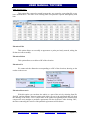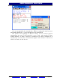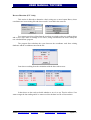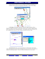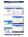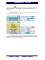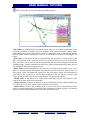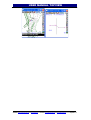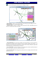
1
USER MANUAL TOPVIEW WORK PROGRAM FOR TOTAL STATION SURVEYING AND GPS Versión 1.3 - February - 2014 Websites: www.northsurveying.com / www.topview.es E-mails: [email protected] / [email protected] Página1 USER MANUAL TOPVIEW Overview of MENU Introduction. Preliminary Considerations. Beginning with Topview Files. (File Management Menu) - Editor stake Bases - Coordinate Editor - Axis Editor Base + Elevation + Superelevations - Profile Editor (Transverse, Longitudinal, Tunnels) - Editor tunnel sections - Editor Typical Sections - Import files - Export files Settings. (Equipment Configuration) - DEVICE - WORK directory - Current - Opt. GPS - Datums and Geoides - Sensor Config - Park Stakeout. (Data Stakeout Menu) - Coordinate File - Sections Fixed - Type Sections - Section Tunnel Takes (Data Capture Menu) - Outstanding Base - Reverse Bisection - Coordinates (speedometer + Stake) - Cross Sections - Transversal Profiles - Longitudinal Profiles Calc (Calculation Menu) Websites: www.northsurveying.com / www.topview.es E-mails: [email protected] / [email protected] Página2 USER MANUAL TOPVIEW - Local Coordinate system (SCL). - Transfer to current SCL - Tools Cogo - Leveling Book - Chop Images (Only Topview PC) Contact Us Installation Procedure Conclusions. Websites: www.northsurveying.com / www.topview.es E-mails: [email protected] / [email protected] Página3 USER MANUAL TOPVIEW INTRODUCTION: Professionally, surveyors need to handle large amounts of data taken from computers that contain projects. Our professional effectiveness depends on the speed and accuracy with which we treat such information. The surveying equipment that we use today contains technical enhancements for the manipulation of large quantities of data and to store them on Pcs. However, the applications integrated into topographic devices are mostly scarce and inadequate, with limited memory and unwieldy to use due to small keyboards. Moreover our data storage inside the measurement equipment requires us to use only them and not others, or we would have to copy and even transform the data from one computer to another. Therefore, an external tool is needed that can use the data transmission capacity of the topographic devices and manipulate this data in a more comfortable environment with a more versatile keyboard, a screen with acceptable resolution, and with a faster microprocessor. It also permits the use of any measuring device without having to pass data from one to another. To meet this need we have developed a powerful, fast, easy and intuitive to use application. It integrates into any PDA and Tablet that has Windows Operating System, either Windows CE 3.0 or above , Pocket PC 2003 or higher , Windows Mobile, and Windows 95/XP/Vista/7. Websites: www.northsurveying.com / www.topview.es E-mails: [email protected] / [email protected] Página4 USER MANUAL TOPVIEW PRELIMINARY SUGGESTIONS: In all PDAs the Ram Memory is a volatile memory with the corresponding risk of losing all stored information when the batteries are depleted. They all also include one or two sockets that allow for the use of non-volatile memory cards such as PCMCIA, Compact Flash, MMC or SD types , and these offer another file system directory. We designed the application so you can choose any of these as the " Base Directory " on which to create the " Working Directory " so that if we choose a directory belonging to the Memory Card we will not lose anything if the batteries drain. Only the program uses the RAM on the PDA. If the PDA runs out of energy the program will be lost, but nothing else. By simply running the installation program on the Memory Card, the software is recovered . Also if we want to check the program on a different PDA simply remove the card, insert it into the new PDA and run the new installation and the program will continue working with the same recent data that was in the previous PDA. Beginning with Topview When you run the program it informs you of the Serial Number and Password for the collector: then it reads a file called "inicia.cfg" containing the last value of all program variables (work directory, device, height Jalon base height, base coordinates, etc ...). Then we are asked to confirm the name of the user or company that is to be shown at the top of the screen. Main program, if the version is TopviewPc we indicate the Screen Size we want to emulate, and if we want to use the physical keyboard of the PDA or the Virtual Keyboard designed by us: Websites: www.northsurveying.com / www.topview.es E-mails: [email protected] / [email protected] Página5 USER MANUAL TOPVIEW The "Scale" option only appears in the PC version allowing you to scale all program windows for better viewing on high resolution equipment. If this is the first time it runs, it show some default values like "Device: GPS Emulator". To choose a device we have to go to the Device Setup menu to a form where you are asked choose between using a GPS or Total Station, we indicate the appropriate communication parameters and other options that are illustrated in the picture. . Similarly to delete, create or choose a working directory to house the data files we go to the Config menu. "Dir.OBRA". Websites: www.northsurveying.com / www.topview.es E-mails: [email protected] / [email protected] Página6 USER MANUAL TOPVIEW If we go to the Config menu CURRENT the program informs us of the current Base Total Station height, Jalon, Base Antenna, Mobile Antenna, Working Directory, Datum, SCL, Corrections from Mobile, etc... After selecting the device and the working directory we can click on the drop-down menus to access all program options. The drop-down menu "File" allows the creation and deletion of files used in other applications as well as the import and export of our project data or fieldwork. The Setup menu allows configuration of certain parameters for starting work. The "Repl" menu allows setting out different dot structures such as files, Sections, digital models, etc.. The "Shot" menu is designed for data collection such as Highlights, Coordinates (stadia), Transversal, Longitudinal, etc.. The "Calc" menu allows additional calculations that do not require communication with the measuring device such as transformations or adjustments, "Utilities Cogo" recalculation of coordinates (stadia), etc.. Websites: www.northsurveying.com / www.topview.es E-mails: [email protected] / [email protected] Página7 USER MANUAL TOPVIEW In any information screen from a calculation allows us to act on it, press Enter to save the data or Esc to discard and exit to a lower level of the application. FILE MENU Selecting Files within TOPVIEW menu allows us to select the following options: EDITOR OF BASES: By selecting this option the following generic menu is shown: The first time you want to do a job you can create all necessary files from this menu with the options from "Create New File" from the relevant module or create them in the Stakeout or Data menus in the relevant modules. If they are already created, we can go to "Use Existing File" and use the editing options. If the computer is to use a GPS, the program previously asks if we want Cartesian or Gepgraphic coordinates. Browsing the directory you can choose the desired file. We have the option, with the bottom tab of the dialog box, to choose geographical or xyz. If we choose XYZ a table appears as follows: Websites: www.northsurveying.com / www.topview.es E-mails: [email protected] / [email protected] Página8 USER MANUAL TOPVIEW Where we can perform all the actions that appear in the header of each column. The Pk_Dist option allows you to analyze any base with respect to an axis. the Conver options (PC version) allows calculation of a geographical basis taking into account the chosen SCL and Datum. The result is expressed in WGS84 geographical. If you have chosen geographical bases, the editing options are: See Bases We can easily move using the cursors () or go to a specific one by displaying the list of bases available in the file. Websites: www.northsurveying.com / www.topview.es E-mails: [email protected] / [email protected] Página9 USER MANUAL TOPVIEW Bases: Insert Base or Add Base Insert is a function that allows you to insert bases. If the base already xists, TOPVIEW informs of the fact and forces you to change the name. The data for insertion of the base are: Bases: Edit Base Once the data has been modified the following scheme is presented: If you press <Enter> the base adopts the modified data as the new values, therwise the base will still show the pre-edited data. If we have renamed and this already exists, the program lets us know and returns to the data to change screen. Websites: www.northsurveying.com / www.topview.es E-mails: [email protected] / [email protected] Página10 USER MANUAL TOPVIEW Bases : Clear This option deletes an existing base in the Bases file. It displays a dialog with the list of available bases, presenting the data on the screen and allowing us to move graphically in different records with cursors ( ) until we choose the base record we want to delete, by clicking "Delete". The program will request confirmation of the deletion. Perp to Axis In this option we can choose a base and an axis by the name of the file it defines, indicating an approximate search PK to analyse, showing the station and resulting displacement. Bases: Order Bases This option allows you to sort numeric and alphanumeric bases by name. If you have used both designations, the program places the bases with umerical designation first and then the bases with alphanumeric esignation. Websites: www.northsurveying.com / www.topview.es E-mails: [email protected] / [email protected] Página11 USER MANUAL TOPVIEW EDIT COORDINATES: In the new version the coordinates editor has the same appearance for ET both GPS and is this: Mod.It allows us to modify data in the table Añad.It allows you to add records in the table Borr.It deletes rows from the table PkD.It allows us to analyze any point on the table with respect to an axis in TopView. Requests use the shaft and then shows the analysis of the result. AzD.It allows to calculate azimuth, distance and increase in dimension between points Area.This option allows us to calculate a surface and its perimeter from the names of the points that we choose, until you want to close with the first. A sketch of the figure formed by the chosen points, perimeter in metres and the surface in m2, Areas, will be displayed and you. Websites: www.northsurveying.com / www.topview.es E-mails: [email protected] / [email protected] Página12 USER MANUAL TOPVIEW You can choose one to one the points we want to make up the figure, several sequences of points in ascending or descending order, or all the file in the order in which it was taken. TopView in the extension of the files of coordinates is *.cox. This kind of file is not editable from the outside environment of TopView. However on leaving the editor coordinates always asks us if we are to generate the file equivalent *.coo, which can be edited with Notepad, Excel…- Websites: www.northsurveying.com / www.topview.es E-mails: [email protected] / [email protected] Página13 USER MANUAL TOPVIEW EDIT AXIS: TOPVIEW allows the introduction of plants (importing files) automatically, manually or semiautomatically. When you create a file with plant generated another elevation law, one for the left elevation, and one for Cambers table that are related to the plant to have the same name but different extensions, thus deleting of plant elevation file is deleted and peraltes associates. EDIT Plant Axis: Shows a table with this structure: Through which, with the use of each one of the functions listed in the table header, we can edit the axis to our choice. It is always advisable to check it after the Cheq option. PkD This option allows you to consult the X coordinate, and azimuth and radius of any point on the path through a Pk and a shift to the left or right of the axis, returning the following information: Websites: www.northsurveying.com / www.topview.es E-mails: [email protected] / [email protected] Página14 USER MANUAL TOPVIEW Check Axis With this option you can verify that data entered manually or via an import from a file, alignments are correct and that there are no errors of overlap which give rise to the calculations of the PK data. the path they are erroneous. Draw With this option you can draw the whole or a part of the axis by selecting Start Pk, final Pk, and the distance between points with which you get is the polygonal that will form the drawing of the shaft. A transverse lines in the starting point of the elements that compose the axis (straight line, curve, ovoid, clotoide) will also be drawn. Websites: www.northsurveying.com / www.topview.es E-mails: [email protected] / [email protected] Página15 USER MANUAL TOPVIEW EDIT Elevation Axis : This option files, cannot be created because they are created to create plant file, as we have outlined above. The name of an existing shaft is requested to operate subsequently with him: Elevation: Edit This option allows us to modify an agreement or point previously entered, asking the Pk that we want to modify. Elevation: Delete This option allows us to delete a PK of the elevation. Elevation: Pk We cannot ask the dimension corresponding to a PK of the elevation, showing us the results on the screen. Elevation: Draw Axis With this option you can draw the whole or a part of the axis by selecting Start Pk, final Pk, and the distance between points with which you get is the polygonal that will form the drawing of the shaft. A few vertical lines at the points of beginning of the elements that compose the axis (straight or parabolic agreement) will also be drawn. After clicking "OK", the lines connecting the vertices of the parabolic agreements will be drawn. Websites: www.northsurveying.com / www.topview.es E-mails: [email protected] / [email protected] Página16 USER MANUAL TOPVIEW EDIT CAMBER: This table defines the applicable bankings in the traces. You can enter one by one, can be automatically generated according to a previously-defined parameters and editable by the user, or can be imported from the corresponding PC via the import menu program. Header options have the functions already described in other sections of the program. Websites: www.northsurveying.com / www.topview.es E-mails: [email protected] / [email protected] Página17 USER MANUAL TOPVIEW PROFILE EDITION: As in the rest of the preceding sections we have the same options, use, create and delete. The program asks us if we want to edit, create, or delete a file of Transversals, longitudinal, or tunnels Transversals. This module shows us this table: whose Edition is very similar to that described in other modules. Just comment that the draw option allows us to draw on screen a specific profile, using the entire width of the same and the ratio needed to use all upper screen. It is not necessary to have ordered the cross points previously. Websites: www.northsurveying.com / www.topview.es E-mails: [email protected] / [email protected] Página18 USER MANUAL TOPVIEW Websites: www.northsurveying.com / www.topview.es E-mails: [email protected] / [email protected] Página19 USER MANUAL TOPVIEW TYPE SECTION In this option you can create, delete, or modify files defining of the sections of a linear work of type road, railway, Canal, pipe, etc... There are elements that are defined Parametrically and other renowed. Define renowed all ditches, slopes of cut and fill (including benches, berms of clearance, crowns, etc.), inadequate fixed platforms (i.e., car parks, steely, etc.), and inadequate fixed sub-grade (i.e., different thicknesses under zones of parking, steely, etc...). All of them are defined as parameters. - Driveways and Verges Upon entering each of the tables there is a menu of identical to all of them is asking us if we want to change, add, delete, view, or calculate the result in a particular Pk. On the road shoulders you can specify a slope for that item will be applied provided that the cant deficiency is less than this. Walkways will apply the resulting slope of cambers table interpolation. If we consult a particular Pk we will get the result of the interpolation in the absence of knowing the corresponding banking in the Pk. Websites: www.northsurveying.com / www.topview.es E-mails: [email protected] / [email protected] Página20 USER MANUAL TOPVIEW Should take into account that they are also interpolated applicable slopes on the road shoulders and that they will be or not modified by the applicable bankings in the Pk. - FIRM, RIDGE, BERMS This table defines the thickness of the firm, the earrings of the subgrade, the type of subgrade (automatic or parallel Ridge), the slope of the firm (in per one and negative, the widths) of the berms of the firm and its slope (in so many per cent and negative). Here we also note the call to a family of vectors in the entries of "Plt.Fija. I:"(Plataforma Fija Izquierda), "Plt.Fija.D"(Plataforma Fija Derecha), "Sub.Fija.I"(SubRasante Fija Izquierda), "Sub.Fija.D"(SubRasante Fija Derecha). These are names of group or family of vectors that are defined in the table of vectors and applied between the end of the hard shoulder and the top of the berm of the firm. These vectors are usually used to define zones of parking, steely, and a host of unusual elements. We can check the operation of the program if we request the result of the interpolation of a particular Pk will get result of this interpolation. Websites: www.northsurveying.com / www.topview.es E-mails: [email protected] / [email protected] Página21 USER MANUAL TOPVIEW In the elements where calls are defined family of vectors are two names that are found in Pks anterior and posterior to the one requested. Interpolation vector to vector of these families will get a new set of vectors that form the figure of the type section. The slopes of the subgrade and the berms of the firm can be altered in its final application depending on the slopes of the bankings in the Pk. - SLOPES and DITCHES: In this table only defined in that Pk is going to apply family of vectors that define the figure of ditches and slopes. - MEDIUM and ECCENTRICITY: The introduction here of a record makes that he is considered a section type dual carriageway and single carriageway, regardless of that there is or no data on the left elevation axis. If there are no data on this axis, but there is data in this table shall be deemed the section of dual carriageway and shall apply the same dimension (elevation right shaft dimension) in both white bands. If any data on both axes and data also in this table applies each dimension for each white band. There is no data in this table are considered single carriageway. Define eccentricity of plant with respect to the cross-section axis, the depth of the internal gutter and the halfwidth of the same ("SemiA.Izq"), the width of the internal hardshoulder ("A.int.Izq:"), the width of the inner berm and its slope ("B.Int.Izq:" and "GDP.)Left"). - VECTORES: Websites: www.northsurveying.com / www.topview.es E-mails: [email protected] / [email protected] Página22 USER MANUAL TOPVIEW This is where lies the power of this module as it is where the families of vectors that make up the figure of ditches, slopes of clearing embankment slopes, fixed platforms and subgrade fixed are defined. These figures or family of vectors have a unique name, which used to be called from the previous tables. It is important not to confuse the names of these families for not applying a ditch where is a slope or a fixed platform, etc.., so we recommend starting the name designating them with the following key words: If a name of a family of vectors for gutter is called "C1 v of..." can be called from the table of EMBANKMENTS and DITCHES as "C1 *", i.e. we can use wildcards for short calls to names. You can define a maximum of 7 vectors to define a figure of the complex who wants to. To define vectors SeudoVerticales recommend to put "0.001" as a horizontal component. When the Pk to be treated between two families of different vector program will proceed to interpolate vector to vector components of these families. This allows us to perform such complex shapes such as transitions between v-shaped ditches u 'U' ditches, slopes bermed climbing and low, slope inclination changing gradually, berms that appear and disappear, berms and coronas of clear change tilt and width, etc., and an endless number of possibilities. To understand this philosophy of work we will give you a simple example. Suppose we have a ditch in "U" shape in a Pk 0 + 100 and another in "V" shape in the KP 0 + 200 and want to occur a progressive transition in a way that the horizontal part of the "U" turns into the apex of the "V". For them we need to have the same vectors in both families and apparently don't have them. The solution is to insert a vector of increments is zero which is going to grow up to become the horizontal part of the "U" at the top of the "V". Websites: www.northsurveying.com / www.topview.es E-mails: [email protected] / [email protected] Página23 USER MANUAL TOPVIEW In these images we see two different types of gutters, one V-shaped and one in form of u. can check as it operates the program when it comes to interpolate two families of vectors option consult a Pk-attending. Program will not request a Pk of application for each family of vectors, and a Pk to check the result of the interpolation: If we look at the "2 Vector' we can check if the desired interpolation has actually been. Other vectors have not changed because they are the same in both families. If any of them were also different had obtained a vector product of two vector interpolation. This philosophy applies to all the elements that are defined in this way are EMBANKMENT slopes, slopes of DISASSEMBLE, and sub-grade fixed, fixed platform. - Calculate PK Profile This option is the calculation of all the tables together resulting in the visual result of the generated section. To do this, the program prompts an axis, a Pk, disassemble or fill in each of the banks, and the surfaces that you want to draw that they may be: all flush + embankments, subgrade + slopes, single package of firm. Websites: www.northsurveying.com / www.topview.es E-mails: [email protected] / [email protected] Página24 USER MANUAL TOPVIEW In this graphical display we can move through the points that comprise it showing on the top data on this point as it is distance to shaft, the dimension, the element that defines, and the slope of the same. Here is an example of a street in a housing development with steely on both sides and parking on the left bank: Composed of the following vectors: - Vectors of the firm in parking and sidewalks: - Vectors of the subgrade in parking and sidewalks: - Vector of the surface area of only sidewalks: Websites: www.northsurveying.com / www.topview.es E-mails: [email protected] / [email protected] Página25 USER MANUAL TOPVIEW - Vectors of the subgrade in area of only sidewalks: Here is an example of a clearing with a berm that rises up to change of inclination of slope 1/1 on the outside to 2/1 on the inside: Websites: www.northsurveying.com / www.topview.es E-mails: [email protected] / [email protected] Página26 USER MANUAL TOPVIEW IMPORT MENU Bases&Coord. This option BASES & COORDINATE data, in the following formats of Ascii files are imported: In all the options of the menu import can browse the Pc, and able to choose the file without having to type it. The program automatically detects which is the delimiter of the fields to avoid having to define it. AXIS On this option path in plant and elevation data (both at the same time), are imported in format Ascii files: Websites: www.northsurveying.com / www.topview.es E-mails: [email protected] / [email protected] Página27 USER MANUAL TOPVIEW Formato Interno: * PLANTA ----------- +++++++++++ ----------0.0000 0.000 325180.945 383.3420 383.342 325009.594 463.3420 463.342 324971.949 554.0670 554.067 324918.271 634.0670 634.067 324862.128 691.9370 691.937 324821.899 881.4800 881.480 324758.810 * ALZADO ----------- +++++++++++ ----------0.0000 0.000 576.908 36.0000 36.000 575.268 147.0000 147.000 572.520 378.0000 378.000 571.340 486.0000 486.000 571.886 620.0000 620.000 566.873 818.0000 818.000 573.013 +++++++++++ ----------- +++++++++++ ----------- +++++++++++ ----------4252061.317 229.5011 0.000 0.000 0.000 383.342 4251718.404 229.5011 0.000 200.000 500.000 80.000 4251647.840 234.5941 500.000 0.000 500.000 90.725 4251574.853 246.1456 500.000 200.000 0.000 80.000 4251517.894 251.2385 0.000 125.000 -270.000 57.870 4251476.335 244.4160 -270.000 0.000 -270.000 189.543 4251301.707 199.7247 -270.000 125.000 0.000 57.870 +++++++++++ ----------- +++++++++++ ----------- +++++++++++ ----------- +++++++++++ ----------0.000 -4.556 -4.556 0.000 576.908 0.000 576.908 PK.INICIO 3350.000 -4.556 -2.476 1.162 576.855 70.838 574.406 CONCAVO 3600.000 -2.476 -0.511 111.633 573.396 182.367 572.339 CONCAVO 9000.000 -0.511 0.506 332.263 571.574 423.737 571.571 CONCAVO 2500.000 0.506 -3.741 432.917 571.618 539.083 569.900 CONVEXO 2100.000 -3.741 3.101 548.158 569.561 691.842 569.101 CONCAVO 5700.000 3.101 -0.617 712.050 569.727 923.950 572.360 CONVEXO Formato Clip: *PLT1 VILLANUEVA DEL DUQUE - CRUCE CUARTENERO 0.0000 , 325180.9450 , 4252061.3170 383.3415 , 325009.5936 , 4251718.4039 463.3415 , 324971.9494 , 4251647.8399 554.0667 , 324918.2708 , 4251574.8529 634.0667 , 324862.1276 , 4251517.8941 691.9371 , 324821.8985 , 4251476.3347 *ALZ1 VILLANUEVA DEL 0.000 , 10.000 , 83.000 , 191.000 , 233.000 , 259.000 , , , , , , , 229.5011 229.5011 234.5941 246.1456 251.2385 244.4160 , , , , , , 0.0000 0.0000 500.0000 500.0000 0.0000 -270.0000 , , , , , , 0.0000 0.0000 200.0000 0.0000 200.0000 125.0000* PLANTA DUQUE-HINOJOSA DEL DUQUE 651.831C , 0R 652.007C , 2000R 652.871C , 15000R 1.3096P , 500R 652.623C , 0R 651.487C , 0.000T ó también ᄂ VILLANUEVA DEL DUQUE - CRUCE CUARTENERO 24-04-2002 P g. 1 PUNTOS SINGULARES P.K. ========== Longitud ========= Coord. X =========== Coord. Y =========== Azimut ========== Radio ========== 0.000 383.342 463.342 554.067 634.067 691.937 881.480 0.000 383.342 80.000 90.725 80.000 57.870 189.543 325180.945 325009.594 324971.949 324918.271 324862.128 324821.899 324758.810 4252061.317 4251718.404 4251647.840 4251574.853 4251517.894 4251476.335 4251301.707 229.5011 229.5011 234.5941 246.1456 251.2385 244.4160 199.7247 0.000 0.000 500.000 500.000 0.000 -270.000 -270.000 VILLANUEVA DEL DUQUE-CRUCE DEL CUART. 24-04-2002 P g. Param. ========= X Centro =========== Y Centro =========== 200.000 324543.972 324543.972 4251906.365 4251906.365 325028.808 325028.808 4251302.874 4251302.874 200.000 125.000 1 DATOS DE ENTRADA N§ P.K. === =========== 1 2 3 4 5 6 7 0.000 36.000 147.000 378.000 486.000 620.000 818.000 Cota p(%) ========= ========= 576.908ù 575.268 572.520ù 571.340 571.886ù 566.873ù 573.013ù -4.5551ù -2.4759 -0.5108ù 0.5053 -3.7406 3.1007 L Kv Flecha ========= ========= ========= 69.653 70.742 91.455 106.148 143.667 211.874 3350ù 3600ù 9000ù -2500ù 2100ù -5700ù 0.181 0.174 0.116 -0.563 1.229 -0.984 Formato ISPOL: Ficheros “ceje1.res” y “rasa1.res” Istram5.12 23 Abr 2002 11:33 PROYECTO : EJE : 1: VILLANUEVA DEL DUQUE - PEÑARROLLA PUEBLONUEVO pagina 1 ============================================ * * * LISTADO DE LAS ALINEACIONES * * * ============================================ Websites: www.northsurveying.com / www.topview.es E-mails: [email protected] / [email protected] Página28 USER MANUAL TOPVIEW Dato TIPO LONGITUD P.K. X TANGENCIA Y TANGENCIA RADIO PARAMETRO AZIMUT Cos/Xc/Xinf Sen/Yc/Yinf ---- ------- ------------ ------------ ------------ ------------ ------------ ------------ ------------ ------------ -----------1 RECTA 383.337 0.000 325180.945 4252061.317 229.5011 -0.4469941 -0.8945369 2 CLOT. 80.010 383.337 325009.596 4251718.408 200.013 229.5011 325009.596 4251718.408 3 CIRC. 90.720 463.347 324971.947 4251647.835 500.000 234.5947 324543.972 4251906.365 4 CLOT. 80.000 554.067 324918.271 4251574.853 200.000 246.1455 324862.127 4251517.894 5 CLOT. 57.870 634.067 324862.127 4251517.894 125.000 251.2385 324862.127 4251517.894 6 CIRC. 189.543 691.937 324821.898 4251476.335 -270.000 244.4160 325028.808 4251302.874 7 CLOT. 57.870 881.480 324758.810 4251301.707 125.000 199.7247 324763.189 4251244.032 Istram5.12 23 Abr 2002 11:33 PROYECTO : EJE : 1: VILLANUEVA DEL DUQUE - PEÑARROLLA PUEBLONUEVO pagina 1 ================================================= * * * E S T A D O D E R A S A N T E S * * * ================================================= PENDIENTE LONGITUD PARAMETRO V E R T I C E ENTRADA AL ACUERDO SALIDA DEL ACUERDO ( % ) ( m ) ( kv ) p.k. cota p.k. cota p.k. cota ------------ ------------ ------------ ------------ ------------ ------------ ------------ ------------ -----------0.000 576.908 -4.555556 69.676 3350.000 36.000 575.268 1.162 576.855 70.838 574.406 -2.475676 70.735 3600.000 147.000 572.520 111.633 573.396 182.367 572.339 -0.510823 91.474 9000.000 378.000 571.340 332.263 571.574 423.737 571.571 0.505556 106.165 2500.000 486.000 571.886 432.917 571.618 539.083 569.900 -3.741045 143.683 2100.000 620.000 566.873 548.158 569.561 691.842 569.101 3.101010 211.900 5700.000 818.000 573.013 712.050 569.727 923.950 572.360 Formato MDT: Planta: 0.000 74.688 89.269 95.961 142.065 213.841 234.440 Alzado: 0.000 234.440 9259.885 9295.213 9302.110 9305.023 9322.097 9348.678 9362.179 16.000 18.344 5391.355 5457.159 5470.006 5476.025 5518.850 5585.523 5600.596 0.000 0.000 0.000 0.000 Formato CARTOMAP: Planta: P.K. X 0+000.000 0+130.223 0+162.223 0+216.012 0+248.012 0+306.637 0+338.637 0+408.906 31.36654 31.36654 33.27631 24.15199 24.15199 25.73198 67.27033 0.000 0.000 0.000 0.000 0.000 0.000 0.000 0.000 0.000 -46.500 0.000 0.000 31.570 0.000 0.000 0.000 Y Cota Azimut 4622.835 9628.938 293.626 4727.740 9551.782 294.110 4755.263 9535.745 289.572 4805.218 9547.113 291.218 4823.093 9573.480 287.917 4850.640 9625.230 278.343 4868.514 9651.597 276.561 4933.029 9655.404 289.258 Longitud Tipo 140.3711 130.223 140.3711 32.000 119.9992 53.789 51.5131 32.000 31.1412 58.625 31.1412 32.000 51.5131 70.269 140.9827 32.000 Radio Parámetro Recta Clotoide -50.000 40.000 Curva -50.000 Clotoide -50.000 40.000 Recta Clotoide 50.000 40.000 Curva 50.000 Clotoide 50.000 40.000 Alzado: ALINEACIONES EN ALZADO INICIO 0 ENTRADA 6.586 VERTICE 25.353 SALIDA 44.12 ENTRADA 271.8754 VERTICE 326.3254 SALIDA 380.7754 FINAL 384.1549 Formato ACS-MDW: Planta: 1 2 3 4 5 6 7 8 9 10 11 12 7080.058 287236.375 7511.901 287526.482 7667.926 287634.238 8292.581 288189.243 8448.606 288344.734 8604.631 288500.224 9070.186 288931.310 9226.211 289055.573 9353.893 289158.199 9719.419 289507.854 9847.101 289633.329 9987.551 289771.516 Alzado tipo 1: 1 2 3 4 5 6 7 8 9 10 11 12 13 150 149.7749 149.1332 147.9884 134.0954 130.7739 134.0409 134.2437 7080.058 19.450 7546.408 22.249 8003.320 29.006 8402.010 38.405 9118.123 45.031 9322.068 43.997 9917.999 49.854 10097.295 10542.779 11265.941 12943.974 13354.381 14125.642 -3.419 -3.419 -1400 -6.1 -6.1 900 6 6 4822172.866 4821852.981 4821740.201 4821476.309 4821463.922 4821451.534 4821287.159 4821192.875 4821117.040 4821036.385 4821059.604 4821084.016 153.1053 0.000 0.000 431.843 153.1053 -0.001 395.000 156.025 148.1389 -1000.000 0.000 624.655 108.3722 -1000.000 -395.000 156.025 103.4057 0.001 395.000 156.025 108.3722 1000.000 0.000 465.555 138.0103 1000.000 -395.000 156.025 142.9767 -0.001 265.000 127.682 135.5872 -550.000 0.000 365.526 93.2779 -550.000 -265.000 127.682 85.8883 0.001 265.000 140.450 94.8297 500.000 0.000 614.194 0.0060015 0.000 466.350 0.0060015 26000.000 456.912 0.0235750 0.000 398.690 0.0235750 -25000.000 716.113 -0.0050695 0.000 203.944 -0.0050695 20000.000 595.931 0.0247270 0.000 179.296 54.288 0.0247270 20000.000 445.484 70.265 0.0470012 0.000 723.163 104.254 0.0470012 -40000.000 1678.033 147.926 0.0050504 0.000 410.407 149.999 0.0050504 25000.000 771.260 165.791 0.0359008 0.000 457.458 Alzado tipo 2: Websites: www.northsurveying.com / www.topview.es E-mails: [email protected] / [email protected] Página29 USER MANUAL TOPVIEW 1 2 3 4 5 6 7 8 7080.058 19.450 7774.864 23.620 8760.067 46.846 9620.032 42.486 10320.037 12104.958 13740.012 14583.100 26000.000 456.902 -25000.000 716.120 20000.000 595.939 59.795 20000.000 143.689 -40000.000 151.946 25000.000 182.214 1.004 0.0175732 -2.564 -0.0286448 2.220 0.0297970 445.490 1.240 0.0222745 1678.061 -8.800 -0.0419515 771.284 2.974 0.0308514 Formato InRoad: Planta: * BENTLEY HORIZONTAL ALIGNMENT TO ASCII * * Nombre de la alineación: ytu * Descripción de la alineación: * Estilo de alineación: default * {TYPE STATION RADIUS X_CRD Y_CRD DIRECTION SPI_LENGTH LIN 0+000.000 0.000 1027846.961 SPI 0+031.076 0.000 1027864.721 CIR 0+071.076 100.000 1027889.671 SPI 0+127.323 0.000 1027938.875 LIN 0+167.323 0.000 1027978.716 CIR 0+192.076 50.000 1028003.468 116276.004 116301.505 116332.679 116358.372 116361.031 116361.031 38.7272 38.7272 51.4596 87.2676 100.0000 100.0000 0.000 40.000 0.000 40.000 0.000 0.000 Alzado: * BENTLEY VERTICAL ALIGNMENT TO ASCII * * Nombre de la alineación: ytu * Descripción de la alineación: * Estilo de alineación: default * { TYPE STATION ELEVATION SLOPE VC_LENGTH LIN 0+000.332 292.901 PAR 0+068.374 295.536 LIN 0+168.374 296.728 PAR 0+266.281 295.268 LIN 0+316.281 293.709 PAR 0+349.372 292.139 LIN 0+429.372 289.975 0.039 0.039 -0.015 -0.015 -0.047 -0.047 -0.007 0.000 100.000 0.000 50.000 0.000 80.000 0.000 Formato TRAZADO: Planta: Fichero: C:\TRAZADO\CAMINOS\WIN\CAMINO1 Título: C:\trazado\ejemplo1\win\CAMINO1 Fecha: 22/02/04 20:31:26 ALIN TIPO P.K. LONGITUD X Tang. XC o I Y Tang. YC o I AZIMUT RADIO PARAMETRO 1 RECTA 0,000 0,020 683396,793 0,000 4300226,714 0,000 26,6250 0,000 2 CIRC. 0,020 0,000 683396,801 683396,810 4300226,732 4300226,728 26,6250 0,010 3 RECTA 0,020 112,932 683396,801 0,000 4300226,732 0,000 26,9138 0,000 4 CIRC. 112,952 20,909 683443,135 683370,178 4300329,722 4300362,544 26,9138 -80,000 5 RECTA 133,861 42,325 683449,138 0,000 4300349,689 0,000 10,2746 0,000 Alzado: Nombre del fichero del alzado : C:\TRAZADO\CAMINOS\WIN\CAMINO1 Título: CAMINO1 Fecha/hora última modificación: 24/02/04 14:35:48 NR P.K. COTA PENDIENTE%/PARAMETRO P.K. INICIO 0,0000 485,4800 1,5997 1 TANGENTE ENTRADA VERTICE TANGENTE SALIDA 4,9999 4,9999 5,0000 485,5600 485,5600 485,5600 1,5997 0,0010 9,1333 2 TANGENTE ENTRADA VERTICE TANGENTE SALIDA 11,2932 19,9989 28,7046 486,1348 486,9299 487,5566 9,1333 -900,0000 7,1987 3 TANGENTE ENTRADA VERTICE TANGENTE SALIDA 57,5172 73,7597 90,0022 489,6307 490,8000 491,4416 7,1987 -1000,0000 3,9502 Section Fixed. Websites: www.northsurveying.com / www.topview.es E-mails: [email protected] / [email protected] Página30 USER MANUAL TOPVIEW This option of Transversals mortising profiles or Natural terrain files are imported for its subsequent reconsideration in field. The formats supported are: ISPOL: You can import any surface an Ispol profiles file. You only need to specify the number of axis and the line type to import. CLIP: - *TER 0, 10 , -36.67, -17.32, -0.25, 16.77, 31.67, 34.44, 38.71, 43.65, 46.11, 50.66, TER File: You can import in order to check if a mapping is similar to the real field, or simply to accompany the display of other layout (flush or subgrade) profiles 0 , 0 577.09 577.00 576.91 576.72 576.67 575.65 575.63 575.73 576.22 576.00 ᄂ The CLIP profiles listing: You can import with the purpose of the reconsideration of the same or as surface to visualize. VILLANUEVA DEL DUQUE-CRUCE DEL CUART. 24-04-2002 P g. 1 LISTADO DE PUNTOS DE SUBRASANTE P.K. C. Eje =========== 0 ÄÄÄÄÄÄÄÄÄÄÄÄÄÄÄÄÄÄÄ DERECHA ÄÄÄÄÄÄÄÄÄÄÄÄÄÄÄÄÄÄÄÄ B.Int. Arista B.Ext. Ext.Tal. Pie Tal. ======== ======== ======== ======== ======== EN ESTRUCTURA 20 575.070 -7.20 576.059 -6.78 574.799 -6.76 574.799 0.00 575.070 6.76 574.799 6.78 574.799 7.17 575.961 40 574.331 -7.09 574.780 -6.78 574.061 -6.76 574.061 0.00 574.331 6.76 574.061 6.78 574.061 7.15 575.176 60 573.712 -6.96 573.976 -6.78 573.441 -6.76 573.441 0.00 573.712 6.76 573.441 6.78 573.441 7.08 574.349 80 573.199 -6.96 573.480 -6.78 572.928 -6.76 572.928 0.00 573.199 6.76 572.928 6.78 572.928 7.03 573.689 100 572.704 -7.09 573.110 -6.78 572.433 -6.76 572.433 0.00 572.704 6.76 572.433 6.78 572.433 7.03 573.192 ᄂ ÄÄÄÄÄÄÄÄÄÄÄÄÄÄÄÄÄÄ IZQUIERDA ÄÄÄÄÄÄÄÄÄÄÄÄÄÄÄÄÄÄÄ Pie Tal. Ext.Tal. B.Ext. Arista B.Int. ======== ======== ======== ======== ======== Platform of the CLIP list: You can import with the purpose of the reconsideration of the same or as surface to visualize. VILLANUEVA DEL DUQUE-CRUCE DEL CUART. 28-12-2001 P g. 1 PUNTOS DE PLATAFORMA Websites: www.northsurveying.com / www.topview.es E-mails: [email protected] / [email protected] Página31 USER MANUAL TOPVIEW P.K. =========== 0 20 40 - Lado ==== Pie I. ======== Arc‚n I. ======== Mediana ======== Calzada ======== Arc‚n ======== Berma ======== Pie T.F. ======== Izq. 0.00 576.908 -3.50 576.838 -4.00 576.828 -4.50 576.788 -6.76 575.658 Der. 0.00 576.908 3.50 576.838 4.00 576.828 4.50 576.788 6.76 575.658 Izq. 0.00 576.050 -3.50 575.980 -4.00 575.970 -4.50 575.930 -6.76 574.799 Der. 0.00 576.050 3.50 575.980 4.00 575.970 4.50 575.930 6.76 574.799 Izq. 0.00 575.311 -3.50 575.241 -4.00 575.231 -4.50 575.191 -6.76 574.061 Cross section of the CLIP list: You can import with the purpose of the reconsideration of the same or as surface to visualize. VILLANUEVA DEL DUQUE-CRUCE DEL CUART. 30-04-2002 P g. 1 LISTADO DE PUNTOS DE PERFILES TRANSVERSALES P.K. 20 COTA RASANTE C.D. COTA RASANTE C.I. 576.050 576.050 ÄÄÄÄÄÄÄÄTALUDESÄÄÄÄÄÄÄÄÄ Dist. Cota Talud ======= ======== ======= -7.20 576.059 -6.78 574.799 0.333 -6.77 574.799 H -6.76 574.799 H 6.76 6.77 6.78 7.17 574.799 574.799 574.799 575.961 ÄÄÄÄÄÄPLATAFORMAÄÄÄÄÄÄ Dist. Cota Pend. ======= ======== ===== -4.50 -4.00 -3.50 0.00 3.50 4.00 4.50 575.930 575.970 575.980 576.050 575.980 575.970 575.930 -8.0 -2.0 -2.0 -2.0 -2.0 -8.0 H H 0.333 ÄÄÄSUBRASANTEÄÄÄ Dist. Cota ======= ======== -6.76 574.799 0.00 575.070 6.76 574.799 TCP-IP: - Fichero de Transversales *.tra: - Fichero de Replanteo múltiples de líneas *.rep: CARTOMAP: - Fichero de Terreno *.txt: P.K. Distancia X Y Cota terreno Código 0+000.000 -30.000 4640.610 9653.105 301.707 0.000 4622.835 9628.938 293.626 0.010 4622.829 9628.930 293.624 30.000 4605.060 9604.771 287.080 0+020.000 -30.000 4656.721 9641.256 306.226 -21.600 4651.744 9634.489 303.838 -0.530 4639.261 9617.515 296.994 0.000 4638.947 9617.088 296.892 11.980 4631.849 9607.437 294.566 21.632 4626.130 9599.662 292.460 L. Eléctrica 30.000 4621.172 9592.921 290.634 - Fichero de Niveles *.txt: P.K. Nivel X Y 0+000.000 Terreno real Nivel 1 4629.439 4626.380 4626.034 4625.146 4622.835 4620.524 4619.636 4619.290 4609.051 Nivel 2 4626.380 4622.835 4619.290 Distancia Cota terreno 9637.917 9633.758 9633.288 9632.080 9628.938 9625.796 9624.588 9624.118 9610.196 9633.758 9628.938 9624.118 -11.146 296.629 296.129 -0.500 -5.983 295.238 299.570 4.333 -5.400 295.081 299.862 4.781 -3.900 294.677 299.922 5.245 0.000 293.626 300.000 6.374 3.900 292.775 299.922 7.147 5.400 292.448 299.862 7.414 5.983 292.320 299.570 7.250 23.265 288.549 288.049 -0.500 -5.983 295.238 299.570 4.333 0.000 293.626 299.690 6.064 5.983 292.320 299.570 7.250 Websites: www.northsurveying.com / www.topview.es Cota sección E-mails: [email protected] / [email protected] Dif. cotas Página32 USER MANUAL TOPVIEW INROAD: - Listado RoadWay_Modeler_XYZ *.dat: January 7. 2002 12:17 PM Layer Name: w HA: 1 VA: 1 Station 0+000.814 Roadway Modeler W/xyz Report Template: ROADWAY_MODELER_XYZ Page 1 of 52 TC Left_Uncon Offset -7.8728 X coord 4738.2903 Y coord 9347.1126 Orig. El.: Cut-Fill Ht.: Z coord 243.5355 243.5355 0.0000 0+000.814 Left_Uncon -7.0000 4739.1085 9346.8086 Orig. El.: Cut-Fill Ht.: 242.6611 243.4627 -0.8016 0+000.814 Left_Uncon -3.5000 4742.3893 9345.5895 Orig. El.: Cut-Fill Ht.: 242.6811 242.3364 0.3447 0+000.814 Centerline 0.0000 4745.6701 9344.3704 Orig. El.: Cut-Fill Ht.: 242.7011 241.4551 1.2461 0+000.814 Centerline 0.0000 4745.6701 9344.3704 Orig. El.: Cut-Fill Ht.: 242.7011 241.4551 1.2461 SDR-VARIN: - Listado Pk,Desplazamiento,Cota del Sdr-Varin: Se puede importar con la finalidad del replanteo de la misma o como superficie a visualizar 0.000,-5.000,510.512 0.000,0.000,510.612 0.000,5.000,510.512 20.000,-5.000,510.725 20.000,0.000,510.825 20.000,5.000,510.725 CARTOMAP: - Terreno P.K. Distancia X Y 0+000.000 -30.000 4640.610 0.000 4622.835 9628.938 0.010 4622.829 9628.930 30.000 4605.060 9604.771 0+020.000 -30.000 4656.721 -21.600 4651.744 9634.489 -0.530 4639.261 9617.515 0.000 4638.947 9617.088 11.980 4631.849 9607.437 21.632 4626.130 9599.662 30.000 4621.172 9592.921 - Cota terreno Código 9653.105 301.707 293.626 293.624 287.080 9641.256 306.226 303.838 296.994 296.892 294.566 292.460 L. Eléctrica 290.634 Sección .K. Nivel X Y Distancia Cota terreno Cota sección cotas 0+000.000 Terreno real Nivel 1 4629.439 9637.917 -11.146 296.629 296.129 -0.500 4626.380 9633.758 -5.983 295.238 299.570 4.333 4626.034 9633.288 -5.400 295.081 299.862 4.781 4625.146 9632.080 -3.900 294.677 299.922 5.245 4622.835 9628.938 0.000 293.626 300.000 6.374 4620.524 9625.796 3.900 292.775 299.922 7.147 4619.636 9624.588 5.400 292.448 299.862 7.414 4619.290 9624.118 5.983 292.320 299.570 7.250 4609.051 9610.196 23.265 288.549 288.049 -0.500 Nivel 2 4626.380 9633.758 -5.983 295.238 299.570 4.333 4622.835 9628.938 0.000 293.626 299.690 6.064 4619.290 9624.118 5.983 292.320 299.570 7.250 Nivel 3 Nivel 4 Nivel 5 Nivel 6 Nivel 7 Websites: www.northsurveying.com / www.topview.es E-mails: [email protected] / [email protected] Dif. Página33 USER MANUAL TOPVIEW Nivel 8 Nivel 9 INROAD: - Fomato 1: May 23, 2002 Roadway Modeler W/xyz Page 09:47 PM Report Template: ROADWAY_MODELER_XYZ Layer Name: bit HA: Haggarty Road VA: resurf Station TC Offset X coord Y coord 0+588.265 Izquierda_ -3.8008 1028222.0617 116402.8019 Orig. El.: Cut-Fill Ht.: 1 of 109 Z coord 295.1566 295.3567 -0.2001 0+588.265 LEOM -3.7399 1028222.1226 116402.8048 Orig. El.: Cut-Fill Ht.: 295.3596 295.3596 0.0000 0+588.265 Izquierda_ -3.6604 1028222.2020 116402.8086 Orig. El.: Cut-Fill Ht.: 295.3611 295.3611 0.0000 E-mails: [email protected] / [email protected] Página34 - formato 2: Fecha: martes, 08 de marzo de 2005 13:14:58 Nombre superficie: Ras5_5'D Nombre alineación: CALLED 0+000.000 -13.519 601.665 IZDA_Desmonte1 0+000.000 -12.430 601.120 IZDA_Ta_Sal_cuneta1 0+000.000 -11.430 601.120 IZDA_Ta_entrd_cune1 0+000.000 -9.510 602.400 IZDA_Berma_Izq1 0+000.000 -8.760 602.400 IZDA_Ace_Izq1 0+000.000 -5.760 602.340 IZDA_Bor_Izq1 0+000.000 -5.750 602.200 IZDA_Apar_Izq1 0+000.000 -3.250 602.150 IZDA_Calzada_Izq11 0+000.000 0.000 602.215 Eje 0+000.000 3.250 602.150 DCHA_Calzada_Der11 0+000.000 5.750 602.200 DCHA_Apar_Der1 0+000.000 5.760 602.340 DCHA_Bor_Der1 0+000.000 8.760 602.400 DCHA_Ace_Der1 0+000.000 9.510 602.400 DCHA_Berma_Der1 0+000.000 11.430 601.120 DCHA_Ta_entrd_cune1 0+000.000 12.430 601.120 DCHA_Ta_Sal_cuneta1 0+000.000 13.774 601.792 DCHA_Desmonte1 ACS-MDW: 9380.000 -48.492 -46.762 -38.678 -38.158 -37.988 -36.988 -30.432 -29.228 -23.425 -19.825 -18.625 -18.156 -18.025 -17.425 42.393 -16.425 42.473 -13.925 42.673 -12.157 -11.621 -5.500 43.347 -4.500 -4.500 43.427 -3.500 -3.500 43.347 -0.187 -0.043 -0.040 0.000 0.000 42.764 3.500 3.500 44.067 4.500 44.147 4.500 56.705 56.359 56.246 56.245 42.681 42.681 42.393 42.193 41.635 41.635 42.293 42.393 57.574 57.427 55.970 55.890 54.783 54.754 42.727 42.807 43.087 54.133 54.125 54.125 43.447 43.527 Websites: www.northsurveying.com / www.topview.es USER MANUAL TOPVIEW 5.500 12.500 15.000 16.000 16.600 16.661 17.200 18.400 18.912 19.000 19.683 26.991 27.505 27.942 42.077 43.314 70.000 44.227 44.787 44.987 44.907 44.907 44.807 44.500 44.500 44.707 44.907 44.955 44.955 52.946 52.946 53.238 53.413 53.391 52.977 52.955 52.809 PROTOPO: "PK",0.000, "P.K. Origen" -10.971,819.171, Talud1 -6.400,814.600, Talud2 -6.000,814.200, Cuneta1 -4.800,814.600, Berma1 -3.000,814.600, Calzada1 0.000,814.600, Eje 3.000,814.600, Calzada2 4.800,814.600, Berma2 6.000,814.200, Cuneta2 6.400,814.600, Talud3 8.542,816.742, Talud4 EAGLE: User Name: jpla Project: Bellpuig-Preixana Subproject : Bellpuigpreixana , Sub Project No :6 Date: 07-14-05 Time: 09:37:00 Page: 1 R O A D C A L C C R O S S - S E C T I O N S ================================================================================ Surface Name :ExistPavement STATION OFFSET ELEVATION ________________________________________________________________________________ 0+060.000 -19.578 -17.462 -16.740 -14.240 -11.033 -9.802 -6.305 -5.671 -5.640 -5.626 -2.273 -2.222 -1.206 -0.744 0.000 4.045 4.678 5.036 5.501 6.709 21.945 32.934 288.680 288.723 288.922 288.913 289.321 289.472 289.603 289.611 289.610 289.606 288.615 288.630 288.862 288.856 288.857 288.865 288.715 288.610 288.359 287.819 287.834 287.822 LANDXML: <CrossSects name="CAMINO 1"> <CrossSect sta="0.000000" areaCut="0.0000" centroidCut="0.000000" volumeCut="0.0000" areaFill="3.5280" centroidFill="0.235969" volumeFill="0.0000"> <CrossSectSurf name="Existing Surface" desc="TERRENO NATURAL" state="existing"> <PntList2D>-50.000000 235.068013 -45.173750 234.976433 -27.130210 234.661202 0.000000 234.392971 24.169036 234.154017 40.530949 234.453577 50.000000 234.234410</PntList2D> </CrossSectSurf> <CrossSectSurf name="Template Surface" desc="ASFALTO" state="proposed"> <PntList2D>0.000000 235.000000 -3.500000 234.930000 -3.500000 234.830000 0.000000 234.900000 3.500000 234.830000 3.500000 234.930000 0.000000 235.000000</PntList2D> </CrossSectSurf> Websites: www.northsurveying.com / www.topview.es E-mails: [email protected] / [email protected] Página35 USER MANUAL TOPVIEW <CrossSectSurf name="Template Surface" desc="BASE GRANULAR" state="proposed"> <PntList2D>0.000000 234.900000 -3.500000 234.830000 -3.500000 234.930000 -4.500000 234.910000 -4.500000 234.710000 -3.500000 234.730000 0.000000 234.800000 3.500000 234.730000 4.500000 234.710000 4.500000 234.910000 3.500000 234.930000 3.500000 234.830000 0.000000 234.900000</PntList2D> </CrossSectSurf> <CrossSectSurf name="Match Slope" desc="Left" state="proposed"> <PntList2D>-4.500000 234.910000 -4.967912 234.442088</PntList2D> </CrossSectSurf> <CrossSectSurf name="Match Slope" desc="Right" state="proposed"> <PntList2D> 4.500000 234.910000 4.500000 234.910000 5.067126 234.342874</PntList2D> </CrossSectSurf> <CrossSectSurf name="Top Surface" desc="" state="proposed"> <PntList2D>-4.967912 234.442088 -4.500000 234.910000 -3.500000 234.930000 0.000000 235.000000 3.500000 234.930000 4.500000 234.910000 5.067126 234.342874</PntList2D> </CrossSectSurf> </CrossSect> Digital Terrain Models. This option DTM files are imported for its subsequent reconsideration in field. The formats supported are: Nota: The day of the publication of this Manual only available to ISPOL, TCP-IP, InRoad, and import DXF-3dface standard programs. CAMBER Table. This option cant tables are imported for its subsequent reconsideration in field. The formats supported are: Websites: www.northsurveying.com / www.topview.es E-mails: [email protected] / [email protected] Página36 USER MANUAL TOPVIEW Nota: The day of the publication of this Manual only available for programs of ISPOL, CLIP, TCP-IP, Cartomap and InRoad. Websites: www.northsurveying.com / www.topview.es E-mails: [email protected] / [email protected] Página37 USER MANUAL TOPVIEW EXPORT MENU: Bases & Coordinates This option being exported data BASES & Coordinates, in different formats of ASCII files: Bases: If the active device is a GPS program we will offer between export bases in XYZ or Lat.Lon.Alt. Coordinates: It allows to export the following formats: Transverse Profiles This option of transverse profiles data in different formats of Ascii files are exported: Websites: www.northsurveying.com / www.topview.es E-mails: [email protected] / [email protected] Página38 USER MANUAL TOPVIEW Longitudinale Profiles This option being exported data from longitudinal profiles, in different formats of ASCII files: AXIS This option in plant layout, and axis elevation data in Ascii files are exported in the same file: - Fichero formato TOPVIEW Websites: www.northsurveying.com / www.topview.es E-mails: [email protected] / [email protected] Página39 USER MANUAL TOPVIEW SETTINGS MENU This is the appearance of this menu in the new version: DEVICE, WORK, CURRENTLY These three options have been previously described at the beginning, in the section "Starting with Topview". Websites: www.northsurveying.com / www.topview.es E-mails: [email protected] / [email protected] Página40 USER MANUAL TOPVIEW GPS Options: (GPS Only) This menu allows us to act on the Sensor: 1.-Static Mode: In this section we can activate and stop the recording of observations in the internal memory of the receiver then to perform post-processing. This operation is possible both in the GPS-Mobile GPS-based, although GPS-based it is not necessary because configure it parallel observations recording is activated to solve ambiguities in real-time (RTK). During the course of this operation the programme will be taking periodic readings of the State of the satellites and Pdop informing of the minimum, maximum, and read half read, offering for the average time. 2.- Satel View: through this screen we have access to information regarding the status of satellites, their elevation, quality of signal, etc. Websites: www.northsurveying.com / www.topview.es E-mails: [email protected] / [email protected] Página41 USER MANUAL TOPVIEW 3.- NMEA Command. This option allows the activation/deactivation of the emission of different NMEA messages via the serial port of the sensor.- 4.- See memory Displays the internal memory of the sensor.- 5.- Clear memory Delete the data in the internal memory of the sensor 6.- Sound.We activate the emission of sounds in the program based on certain events. 7.- Identify sensor.We can determine the type and serial number of the sensor connected to our address book. 8.- Radio Channel We have access to the change of our Gps (in some cases also to the frequency) channels, as well as certain changes in some parameters via radio transmission/reception. In some sensors as the topcon GR3 plate containing the Radio is the same that contains the GSM/GPRS and from here one or another can be activated. Datums and Geoid: (GPS Only) This option allows us to choose, create, or delete a Datum. Depending on the Datum selected thus be obtained Cartesian coordinates that will be local conversions using the Websites: www.northsurveying.com / www.topview.es E-mails: [email protected] / [email protected] Página42 USER MANUAL TOPVIEW parameters of the SCL. Initially we could choose either one Datum, but it is important to not change Datum in a work, since it can induce substantial errors. Added the option "Load geoid" through which we apply a model of increments relative to the ellipsoid heights obtained directly by GPS for approaching the dimension area geoid. In UTM parameters, or parameters LAMBERT, or parameter ObliqueMERCATOR, etc..., you can specify multiple values influencing the conversion of geographical coordinates on her prior to the SCL Coordeandas XYZ. Websites: www.northsurveying.com / www.topview.es E-mails: [email protected] / [email protected] Página43 USER MANUAL TOPVIEW Websites: www.northsurveying.com / www.topview.es E-mails: [email protected] / [email protected] Página44 USER MANUAL TOPVIEW Classical Settings: (GPS Only) In this module we can configure the GPS equipment as equipment BASE or as a mobile team, indicating the geographical coordinates of the base where is situated the GPSBASE as well as the antenna height, maximum angle of inclination of satellites in use, frequency of sending data to the GPS-mobile through the radio-modem and parameters series, etc.. Extract Average Position: The WGS84 geographic coordinates on the base where we will place the GPS-Base is not available at the start of a new job and will have to remove a coordinate media for the work area. This program will begin taking readings showing the incoming coordinates, the number of readings taken, satellites and Hdop and Vdop read parameters until you press the ENTER or ESC key. Then it will display the result of the average read and imposed it to receiver offering also the possibility of recording the WGS84 geographic coordinate and the Datum used for Cartesian coordinate. Both in this module as others recorded geographic coordinates are always referred to the Datum WGS84. It is very important to know this last to not make mistakes in calculations or subsequent transformations (e.g., using another specialized program). In any screen like this in which has has established communication with the receiver and you are reading coordinates, we can press the key "s" or on the icon and a Websites: www.northsurveying.com / www.topview.es E-mails: [email protected] / [email protected] Página45 USER MANUAL TOPVIEW screen that displays icons indicating: If the receiver is to either Base or mobile; If the radiomodem is receiving; If you are in navigation mode or in floating precision; the Hdop; Vdop; and finally a list of satellites visas with the parameters of the number of the satellite, elevation, Azimut, signal level, State of computing. ICONOS Informativos GPS-Base GPS-Móvil Satellites Radio ON Radio OFF Navegation Mode Float Mode Precision Mode Batery Full Batery Half Batery Low ICONOS y Teclas Activas Escape Key. Enter Key. Satellites. Accuracy, Times, Elevation Mask. Code of Point. Change of height of mobile antenna for GPS. The RTK GPS reset. Switch between graphic display and display text in some modules. Displays the number of point, codes, and the dimension in a graphical display. Additional information of a point and association with an image. Websites: www.northsurveying.com / www.topview.es E-mails: [email protected] / [email protected] Página46 USER MANUAL TOPVIEW Zoom +. Zoom -. Zoom All. Zoom Window. Displays or hides the lines in graphical display. The program will be reporting with messages in the lower-right corner on the events of the configuration. Special mention is the configuration of the wireless modem box. It specifies the parameters COM communication between sensor and the Radio. Each sensor is typically a wireless modem with different parameters and different with what will be necessary to go to the equipment specifications or check with the distributor of GPS to know what are. Once it displays the following message: Impose latitude longitude altitude Is equivalent to the same previous option, but with the difference of the coordinate rather than removed from the Sensor is extracted from a file. This coordinate should not distance more than 50 metres from the autonomous position sensor calculated for the area because otherwise the Base would not send corrections spreads to mobile or if the mobile sends them to discard them. Some sensors are even more stringent and the imposed coordinate should be next. Mobile Sensor Set This option tells the sensor that should act as a receiver of differential corrections and to do this we must indicate the communication parameters series for the wireless modem in addition to the mask lifting height of antenna, satellite, etc.. Corrections from Mobile This option allows us to place GPS Base anywhere ("extract position Media") and continue using the geographical coordinates and the SCL we already have without having to re-read these bases and return to the SCL setting. Websites: www.northsurveying.com / www.topview.es E-mails: [email protected] / [email protected] Página47 USER MANUAL TOPVIEW The principle is based on a translation of WGS84 geographical coordinates from the mobile. So we need to read the coordinates of a base that we had previously read. The program will show us the differences that exist from the current position of the base that will be just a few seconds or tenths of seconds. These differences are stored in a few variables, and recorded in the configuration file. From that moment all the coordinates received from mobile sensor them will be subtracted those differences which is equivalent to position the GPS Base on known coordinates. If we have several mobile GPS we will have to make the transaction with each of them. Each time that you configure the GPS Base these variables go to zero, so if Base sensor is not positioned in a known base should make the corrections again. The advantages of this method are several: 1- The possibility to place GPS Base anywhere more in line with the needs of the moment. 2- Put the Base GPS antennas on the roof of our car and the sensor in the boot thus eliminating the need to monitor the equipment and reducing the emission of the Radio_MODEM distance, because it is assumed that once read all the bases of the work the remaining days will work in localized areas. There is that having in mind that the car should not be moved during the work, and if necessary their mobility should repeat the process of calculation of differences to correct. 3- If a work already exists a GPS based emitting differential corrections, whose wireless modem is compatible with ours and it is information that also emits, we can use these Radio signals and those apply corrections from mobile phone even if its coordinates are different from our. We will arrive at a picture like this: Websites: www.northsurveying.com / www.topview.es E-mails: [email protected] / [email protected] Página48 USER MANUAL TOPVIEW Also we can manually edit measured data (- Edit-), averaging with other base more (take another BASE more...!), accept and dispose of the measurement. The option at the beginning of "Recover history" serves to retrieve previous measurements that may be valid, especially in case of work with networks of Bases NTRIP. Whenever we make a correction is recorded in a file called "CorrMovil.inf" in each directory of work values of measurement together with the name of the base on which it was made, the date and time. Websites: www.northsurveying.com / www.topview.es E-mails: [email protected] / [email protected] Página49 USER MANUAL TOPVIEW Setting Styles (GPS Only) One of the multiple advantages offered by the use of TopView is the possibility of using it with practically the totalizad of computers that are currently on the market. This fact necessitates that it offers the opportunity to modify all the configuration parameters, which sometimes can complicate or slow down the process of the equipment configuration of GPS, which due to their complexity makes the number of parameters to configure is greater and therefore the time required to complete the Setup and the required expertise are higher. The first setting up our team, is a step that necessarily we must be, unless they have already configured us, we have to tell you all those parameters that will allow, for example, our electronic book to communicate with GPS, GPS send through the Radio-Modem information we need every time us. To begin with we can split a configuration type that we can apply by default and then modify those parameters that vary in the configuration that you want to use particularly. Once this step has been made can save your settings to be used in subsequent works that will be used the same composition of team, even when for example you change your address book you can load a previous configuration and modify it, in order to then also keep it and use it at another time, i.e. from a configuration we can adapt it to other similar team composition. Then we will see how you would be the configuration of a team of GPS BASE JAVAD and an electronic book of Topcon's FC-100 connected by cable and GPS ROVER hyper + connected by BlueTooth, which has the following characteristics: Base: Websites: www.northsurveying.com / www.topview.es E-mails: [email protected] / [email protected] Página50 USER MANUAL TOPVIEW Móvil: Websites: www.northsurveying.com / www.topview.es E-mails: [email protected] / [email protected] Página51 USER MANUAL TOPVIEW DEFAULT PARAMETERS We will start by selecting the device that we will work, with this once we go into styles of configuration we can apply a previous configuration for the team we have selected. This configuration applies from the option by default, with which apply an initial configuration that will serve as basis to adapt to the team that we want to work. Parameters of GPS BASE We will begin by configuring the GPS Base, starting as already mentioned parameters by default that we have imposed on it. Select the Base tab to configure it: PDA: This first option that shows us refers to the communication parameters that we will impose on the book so that you can communicate with the GPS, such as port, baud rate, etc. In this case that will be seen in the image above.Radio: with the following option is going has let you to GPS for example the port which is has issue differential corrections, the Radio-Modem and the type of format of the same, the baud rate, etc. For our example will be the following: Varios: in this case we will has allow to enable different options depending on the type of sensor that we have selected as a device, for example going has allow enable / turn off sounds that emit some sensors during use, also is going has allow reset sensor, etc. in our case for the team that we will configure only offers us the option to reset the Sensor, as we see in the image below. Antenna: Here we will indicate the information relating to the antenna, as it is the type of antenna that we are working in addition to the height that is located, the mask lifting, etc. In the next image we see the selection for our example: Coordinades: here indicate you which will has be the source of the coordinates that will have have the GPS-based, offering two options. - Remove middle position: with what team measured its position with the number of times that you indicate. Once applied configuration sensor offers the possibility of saving measures coordinates. - Extract file: with that applying settings ask us the file of bases that is the basis on which we have parked our sensor. Post_Proceso: It finally offers us the possibility of recording in the sensor information in order to subsequently process it in office. You will have to fill in the name of the file of observations and the frequency of recording. Parameters of GPS MOBILE Websites: www.northsurveying.com / www.topview.es E-mails: [email protected] / [email protected] Página52 USER MANUAL TOPVIEW Similar to the configuration of the Base, already start parameters that we have imposed by default, while the final configuration corresponds to what then we indicate: PDA: the configuration of the PDA is usually the same for two sensors, except for cases in which such a sensor available cable and Blue Thoot while another only cable. On our case as we have already specified in the characteristics of the equipment shall be in the following way: Enlace-RTK: Here you can select the differential corrections reception channel. They will usually be by Radio but they can also be for GSM/GPRS and in this case you must specify several parameters: Antena: This option has the same options that the sensor base, as well as allowing you to indicate which will has be the level of ambiguity and multipath. Puerto RTK: in this case select the COM_ port that goes has receive differential corrections, baud rate, parity, etc. Varios: similar to before collects configuration features such as reset Sensor, enable Fast CPD, or as in the case of our equipment enable co-op Traking, etc. . ESTILOS DE CONFIGURACIÓN SAVE SETTING We can save the settings we just determine to avoid this repetitive work whenever we want to work with the same computer, PDA, etc. To do this on the actions tab offers us the option to record the basic configuration and mobile in the same file, whereupon, in the successive times that you fence to be used only will need to load the saved configuration and apply it, without changing any parameter. In our case we'll put it under the name of Hiper_Plus_FC100 being a hyper + team along with the FC-100 notebook configuration, both of topcon. ESTILOS DE CONFIGURACIÓN APPLICATION SETTINGS Websites: www.northsurveying.com / www.topview.es E-mails: [email protected] / [email protected] Página53 USER MANUAL TOPVIEW Once we have defined which will has the setting of each of the sensors and have kept it will spend to implement it, with the tab actions offers us the option to apply those settings to each of the sensors, this must be connected each to the PDA, which can be simultaneously, for this reason, we will begin by connecting the PDA to the sensor base to then apply your setting, when we apply the settings on any computer, will has set communication between the sensor and the PDA. In the case we are discussing, using Bluetooth, there is an intermediate step that is going has allowed to communicate via Bluetooth, for this reason when you apply the configuration appears to us a window that offers us the possibility to select the name of the sensor with which we want to communicate, although there is also the possibility that does not appear any team, even that which appear are not who we are interested in, in this case we have to click the Scan option, so the book will make a sweep to detect Bluetooth to communicate new: After finishing this operation already must appear the name of the sensor you want to communicate, from here only is situanor about our sensor and press the Select button, and selected our sensor and then it will continue to apply the settings. Established, then we disconnect the sensor base to connect the phone to the PDA and can apply in the same way the established configuration. In this way we can begin to work, and that both sensors are already.We may realize that we get connected, or that do not emit or receive Radio Modem, in these cases we can change the settings we create incorrect, return to save the configuration file with the same name and apply it again. COMMUNICATIONS PDA - SENSOR Communication can be set in three different ways: BluetT/Serial, Bluetooth and Cable. Communication cable does not present any problem, so we will discuss the other two options. The classic ports are known by the name of "COM" while the BlueTooth port is known with the name of "BSP", to this must be added the number of the same ("COM1" or "BSP1"). Usually on a PDA port for cable is the COM1 port for Bluetooth can be BSP2 or BSP3. Well, most of the PDAs incorporates a Driver that makes blueTooth emule port conventional "COM_" series with a numeroelevado (6, 7, 8, or 9). In this case we will have to indicate in TopView that "Way" is "BlueT/Serial". Some PDAs (example: FC-100, Unitech socket) when TopView attends BlueTooth Windows Ce operating system (WinCe) automatically opens Explorer devices to select a BlueTooth, while in others this does not occur (example: WorkAbout Pro, Unitec with Anycom) and if we want to change our connection will have to go to the Manager of the Bluetooth to perform this scan and selection. Websites: www.northsurveying.com / www.topview.es E-mails: [email protected] / [email protected] Página54 USER MANUAL TOPVIEW PARKING: (E.T. Only) In this section you park the instrument in UTM or PLANE, through an orientation with another base or a free orientation. Requested file Bases, name of the Base where you Park, the instrument height, and height of the marker. After this data is offered us Orient with another Base or freely orient the device. If any of the chosen basis did not exist in the basis file, we are presented a screen where you can enter the data of the database and decide whether to archive it to the basis file. Then it will show us the result of the calculation of orientation. Websites: www.northsurveying.com / www.topview.es E-mails: [email protected] / [email protected] Página55 USER MANUAL TOPVIEW If we choose only to measure and verify we will have the option to read in direct and reverse circle and get results similar to these: If you select only guide the program will impose an azimuth to the station, and with the third option included the previous two, i.e. focus on another base, will read it and obtain the relative errors in distance, elevation and azimuth. To exit the application program reports data base from which will make all the calculations of reconsideration or take data, as well as the work subdirectory. Websites: www.northsurveying.com / www.topview.es E-mails: [email protected] / [email protected] Página56 USER MANUAL TOPVIEW STAKEOUT MENU All layout options provides we archiving the coordinates of the point restated in field in a file called of receipt which is in reality a coordinates file same as other files used in Taquimetria or reconsideration of files of coordinates. Is often used to be aware of the points really reframed in field as well as the actual dimension of the field at that point, in these codes are automated to indicate the original point which was to rethink and retrieved residual error. COORDINATES This option can rethink groups coordinates from different sources as well as recording the results of the reconsideration in a backup file. TOTAL ESTATION(E.T.): FILE OF COORDINATES, CROSS, BASES The application starts by asking if we want to record the readings in a backup file. If we answer affirmatively are prompted us the name of a file of coordinates other than which we will use to rethink where all the stakeout real data will be stored. Websites: www.northsurveying.com / www.topview.es E-mails: [email protected] / [email protected] Página57 USER MANUAL TOPVIEW It begins by requesting the name of the file to rethink and then will be presented a screen where you can select specific point we want to rethink and azimuth that we put in the ET. You can change the dimension to rethink just change the value "Inc.Z:" which is the value that is added or subtracted to the dimension to rethink. After placing the appliance shown azimuth and milestone online operator, we proceed to checkout by pressing Enter. After reading the program asks for the height of the marker and the code we want to give the point to file in the backup file. After we reported the result of the reconsideration and action to perform: The action "Move" can be changed to "Approach" If the difference in distance is negative. The 'Right' action can be changed to "Left" and reflects the lack of alignment of the layout. "Upload" action can be changed to "Get off" depending on the difference between the real dimension and the dimension to rethink. Subsequently offered follow rethinking this point or return to the screen of choice of point to rethink another. Websites: www.northsurveying.com / www.topview.es E-mails: [email protected] / [email protected] Página58 USER MANUAL TOPVIEW ISOLATED POINT This option can rethink any isolated point by entering the coordinates manually to rethink as well as recording the results of the reconsideration in a backup file. The screens in the application offers are similar to the one explained in the coordinate file layout section. GPS: These three modules to the module "rethink axis" the screen are common and the difference between E.T. and GPS is situated from the option read to Prism. Failing that appears the following screen showing increases relative to the orientation chosen, as well as a graphical display that shows different graphic entities depending on the chosen orientation: - Moving to North: Samples a Vertical line and other Horizontal (Cardinal axes), an arrow at the top of the vertical line that shows the North, and a blinking cursor that is our current position that will change as we move. To place the antenna (GPS-Mobile) in the position of the theoretical point to rethink we move toward the intersection of the cardinal axes by placing the WorkAbout North-oriented. When the distance is less than 0.5 meters book will emit a sound that will be more intense with more fashion we are approaching the point of rethinking. The size of the cursor will change between small when it is in high precision, medium when it is floating or precision medium, and big when is in navigation. - Relative Orientation Movement: Displays a line from the center of the graphical display with an arrow indicating the direction to take and the distance to the point. Websites: www.northsurveying.com / www.topview.es E-mails: [email protected] / [email protected] Página59 USER MANUAL TOPVIEW When the reached distance is less than 1 metre this mode changes to "Guidance to the North". - Orientation Relative to Base: Displays a vertical line from the center of the graphic display and an arrow at the end indicating the orientation towards the Base, and a line that rotates and displays the address that is to rethink point as well as the distance to travel. We can change from one mode to another by pressing the following keys simply: Key "N" or icon changes to mode "Setting out guidance to North" Key "M" or icon changes to mode "Setting out guidance to movement" Key "B" or icon changes to mode "Setting out guidance to a Base" Websites: www.northsurveying.com / www.topview.es E-mails: [email protected] / [email protected] Página60 USER MANUAL TOPVIEW We can check the status of satellites and Pdop, batteries, etc. by pressing just the "S" button or icon . We can also change the GPS-mobile antenna height or point code simply pressing “C” ó “H” , or change the precision tolerances or times that we want to read the point by pressing “P” . Keys and icons described in this paragraph are available in all socket data or layout modules. AXIS This option you can rethink any point of an axis of "plant" + "elevation" + "camber" previously created through its Pk and displacement, as well as recording the results of the reconsideration in a backup file. The application starts by asking if we want to record the readings in a backup file. If we answer that affirmatively will be asked us the name of a file of coordinates other than which we will use to rethink where all the stakeout real data will be stored. Then ask us imaging used. Then if you want to apply table Cambers and medium. If we only want to apply table of Cambers and not the medium we need to create a type section even if it is completely empty so the program can follow the process: It allows the introduction of one Pk either as well as explore the table of singular points of the shaft to extract the Pk of a particular element. Progressive is the distance between Pk that we normally use to rethink, so after rethinking the Pk 1520 and return to this screen, automatically will offer us the Pk 1520 + 20 = 1540 to rethink. Skew is a twist that applies to rethink a profile not perpendicular to the main axis and from this new rotated alignment applies to shaft separation and the Longitudinal displacement in the sense the Pk. commonly used for rethink works of manufactures are not perpendicular to the axis of the trunk but that knowing the angle forming the shaft alignments Websites: www.northsurveying.com / www.topview.es E-mails: [email protected] / [email protected] Página61 USER MANUAL TOPVIEW of the OF and the profile of the intersection with the axis of the trunk)Skew) can rethink it easily from the trunk. The screens then the application offers are similar to the one explained in the coordinate file layout section. ANALYSE POINT It allows to analyse our position with respect to an axis (both on ground and elevation), and can also load a section created by us. The results of this calculation can be stored, as always, in a backup file. Websites: www.northsurveying.com / www.topview.es E-mails: [email protected] / [email protected] Página62 USER MANUAL TOPVIEW DIGITAL TERRAIN MODELS (DTM). In the Menu "Imp" we have the necessary options for importing the DTM of the appropriate PC program. Once we have the DTM in our book we can visualize the DTM, zoom + and-, display the dimensions of the nodes, view the number of the node, etc.. We can take any point and program display its position, highlights the triangle on which sits and shows the increase of dimension needed to touch the plane forming the triangle. We can also engrave read points, being drawn on the screen as well as Tachometric module. In this way we will make a quality control and we know also the area already taken and marked. It also allows the reconsideration of an exact node with only indicate the number of the same. We are, in this case-rethinking the coordinates x, y and z of the node. A restatement of line, selected the points of a digital model is also incorporated. In this case our real position on the line is parsed, but the layout dimension is referred to the theoretical dimension of the digital model in the position in which we find ourselves at all times. Websites: www.northsurveying.com / www.topview.es E-mails: [email protected] / [email protected] Página63 USER MANUAL TOPVIEW Include a number of new icons, whose functions we will explain: It displays a context menu where you can: - Stakeout DTM: at any point in the digital model, we will have the increase in elevation relative to the same. The triangle where we are located is highlighted in red. - Stakeout node: It would be the same to rethink any point but in this case it is a node of the DTM. - Stakeout point on line: Allows you to mark two nodes of the DMT and analyze our position in plant on line to mark triangle of the DTM and the difference in dimension to the triangle. - Load Axis: We can load an axis and draw it next to the DTM. Being loaded shaft to attend the "Rethink DTM" option automatically our situation with regard to the same analyses and to mark the triangle of the DTM where we are located and the difference in elevation to the DTM. The axis of elevation is not used for anything. - USE Images: We can upload, download and calibrate images in various formats (tiff, bmp, and jpeg). To calibrate the image, we would have to choose two common points for the digital model and the image itself. The procedure is simple and will be explained in more detail in the section on "Catch" "Coordinates". Websites: www.northsurveying.com / www.topview.es E-mails: [email protected] / [email protected] Página64 USER MANUAL TOPVIEW - Use DWG/DXF: This is an option that we can load / download in the format exposed autocad drawings, and can also activate / deactivate layers for display or not.- Websites: www.northsurveying.com / www.topview.es E-mails: [email protected] / [email protected] Página65 USER MANUAL TOPVIEW SECTIONS FIXED with E.T.: In this module we can rethink any point of a cross section calculated in a programme such as Clip, Ispol, Sdr-Varin, etc., and imported into the corresponding option in the import menu. Likewise it allows storage of points read in a trail file for later export them to your Pc and calculate the monthly cubicaciones of the work. Taken anywhere allows the calculation of the action to perform for the rectification of the Royal slope to reach the theoretical slope. It begins by offering between deleting an existing file or use it to rethink. The files are only created in the importation of the same from Pc. Then he offers a picture where we can indicate the names of different files to load. Subsequently he displayed the first Pk which is in the file that we are chosen to rethink. Websites: www.northsurveying.com / www.topview.es E-mails: [email protected] / [email protected] Página66 USER MANUAL TOPVIEW With cursors, we can move through all the points of the layout surface and when we have overcome the last point automatically move on to the next profile. We can do Zoom +-, settings with the pointer, etc.. We will have access to a menu of options: - Stake Point: We can rethink the selected point with the cursor from the current base. It allows us to mark a setback on the profile of a distance towards the inside of the shaft or to the outside of it, that distance to follow a horizontal or one of the slopes of the vectors that are supported at the apex, and on this new situation increased dimension. It will show us the coordinate of the point to rethink and azimuth and distance from the current database to the selected point. In "dimension to rethink" offers you default dimension that has the point in the file, but can directly place a distinct or develop a mathematical expression as "67.580 + 0 5" which would give the dimension "68.08" to rethink. It is quite useful to rethink parallel layers in dimension as the package of firm. After taking the appliance reading program informs us of the location of the point taken with respect to the alignment point to rethink with the base and the actions to perform. Websites: www.northsurveying.com / www.topview.es E-mails: [email protected] / [email protected] Página67 USER MANUAL TOPVIEW It then shows with a cross in the position of the point projected on the profile. By pressing a key displayed on screen where reports of the actual position of the point and the actions to perform for its correct position. Si hubiéramos abierto un fichero de perfiles de seguimiento el programa nos preguntaría si deseamos grabar el punto leído. Then asks you if you want to calculate the action to be performed on the slope. If we answer Yes the program will tell us which movement will have to do to put the point on the slope. This we will see in the bottom right of the screen. When those relating increments are zero we will be on the theoretical line of the slope.- The process ends with the question of whether want to rethink another point or follow rethinking it. - Search PK: We can move directly from a profile to another by pressing the up or down arrows, or we can search by particular PK by clicking on the "Search" option and select one from the list of all included in the file of Cajeo PKs to rethink. Websites: www.northsurveying.com / www.topview.es E-mails: [email protected] / [email protected] Página68 USER MANUAL TOPVIEW - Stroll through the file: We can explore profiles displaying them on screen until the end of the file is reached or press ESC. - Regenerate Display: You can clean the screen of points not recorded and displayed in the option of rethinking. - Change Parameter: as the ratio (ratio height/width) and others - Change Active Surface: We chose here the surface we are going to choose for your reconsideration, if we want to change it. - Take Profile: It allows us to take the cross and burn it as one surface more. If you know the location of the profile field (for example because we have reference stakes at the ends) can directly take the points of the profile and save them without having to choose for each reading the theoretical point of rethinking, and even calculate the action on slope unless we find chosen previously theoretician point of the foot or head of the talusthen the search taken point vertically which vector should use for the calculation of the action (although we are chosen to rethink the taken side point). It is undoubtedly a way to quickly and easily take tracking for cubicaciones of the month profile and at the same time indicate the corrections on the shoulders of the slopes. - Geometric Leveling: This option is designed to use a conventional geometric level with your eye and based on the data we have in Software to rethink any point of the section without papers to the field. with GPS: The difference between E.T. and GPS in this module, as in all the of data collection, is the omission of the readings of angles and distance geometry by incoming coordinates from the GPS receiver along with their parameters of Hdop, Vdop, XY accuracy, accuracy in Z, etc. Next to this difference also highlight that the input of coordinates occurs every 0.2 seconds which continuously updates the cursor that represents the location of the GPS-phone, with which we can see our position with regard to the section's work and move towards the point desired in a graphical way. Websites: www.northsurveying.com / www.topview.es E-mails: [email protected] / [email protected] Página69 USER MANUAL TOPVIEW The image on the left shows the reconsideration of a recessed 1 meter towards the outside point following the slope of the previous item, and without any increase in additional dimension. The red line shows the way to continue between our position and the position of the point we want to rethink. The image on the right shows both the joint stakeout of a theoretical point without setbacks and the "action on slope". This "action on slope" processing movements Horizontal and Vertical that we would have to do so that our position pose above in vector that is below our vertical. Therefore these components may change dramatically depending on the vector that this under our focusing on different vectors calculation as we move. The size of the cursor will change between small when it is in High Precision, medium when it is floating or precision medium, and big when is in navigation. Also the display shows the differences between the theoretical profile Pk and Pk which is the antenna of the GPSmobile, and the differences between the distance to the axis of the theoretical point and the point where the GPS-mobile, as well as the movement to move to the correct position. Movements to be carried out are therefore "move forward or backward in PK" and "zoom in or out of the shaft". You can check the status of satellites and Pdop, batteries, etc... by clicking on the corresponding icon. We can also change the height of the antenna GPS-mobile or code point, or change precision tolerances or times that we want to read the point. Websites: www.northsurveying.com / www.topview.es E-mails: [email protected] / [email protected] Página70 USER MANUAL TOPVIEW Includes a new option of "Continuous interpolation" to be able to rethink any profile that is not collected in the list that appears in "Search Pk". Being asked every few meters we want to interpolate. It should take into account that the outcome of this interpolation may be ambiguity in transitional zones of complex sections, in which we move from a number of segments per section to another. I.e. that it is a good choice, knowing the precautions to take, not only in TopView, but in any PC. - Virtual slope: It allows us to define a vector that part of active point of the section and that it can be remove or fill inwards or outwards. In this example, we have defined a vertor 1/1 that part of the gutter and is more inclined that the original (1/0.5), if we move until the bottom right data to zero will be at the intersection of the Virtual slope with the terrain. Websites: www.northsurveying.com / www.topview.es E-mails: [email protected] / [email protected] Página71 USER MANUAL TOPVIEW - Stakeout Points Online: On the basis of two points of drawing that can be the same PK or other PK shows a drawing in plant with drawn axis and the line formed by these points. On these two lines performs an analysis of our position on the axis and the line from two points. Websites: www.northsurveying.com / www.topview.es E-mails: [email protected] / [email protected] Página72 USER MANUAL TOPVIEW TYPE SECTIONS In this module, in its operation, is identical to of rethinking sections banded with the only difference from that instead of choosing the 1st surface to rethink chose the type section to rethink. In contrast to the module of sections banded here there is a file containing all the PKs already calculated, but that the program will generate a file with the Pk and the slopes (remove or fill) that we specify. Cutting with the actual ground them will have to find with the option of "Action on slope" and the decision if it is remove or fill in each of the banks runs from our account, although it is quite clear that if the point taken in field is drawn on the screen below the subgrade is that we must apply fill and remove if not. Otherwise it behaves exactly like the previous module. Note that to be able to load sections banded imported corresponding programme (Clip, Cartomap, MDT, Ispol, etc...) we can verify if they overlap the lines defining the type section with the lines of the Cajeada section is that we have well defined the geometry of the work, and if not we can verify where the differences are and evaluate them. Once we decide that it is completely defined we can delete files sections banded and free up memory for other purposes. Websites: www.northsurveying.com / www.topview.es E-mails: [email protected] / [email protected] Página73 USER MANUAL TOPVIEW MENU TOMA The options that are present in this Menu cover most of operations involving a field or a subsequent analysis of the same data socket. Featured Base(Destacado): This section may highlight or put a new base from the base where this parked the instrument, adding the registration in a designated base file. It should be noted, that for a greater precision of data from the new base are asked to take two readings (direct and reverse) Compensated readings can be recorded in a backup file together with their coordinates as if it were a file of Taquimetria. Websites: www.northsurveying.com / www.topview.es E-mails: [email protected] / [email protected] Página74 USER MANUAL TOPVIEW With GPS: It begins by asking us if we want to take the bases in XYZ or Lat.Lon.Alt. Later she asked if we wish the Cartesian of the selected Datum or local Cartesian coordinates as elected in SCL. If the base exists and reading it will use to process the SCL we choose "Basis at all". The difference between E.T. and GPS in this module, as in all the of data collection, is the omission of the readings of angles and distance geometry of the coordinate geographic and Cartesian inbound from the GPS receiver along with their parameters of Hdop, Vdop, XY accuracy, accuracy in Z, etc. Next to this difference also highlight that the input of coordinates occurs every 0.2 seconds which will have to press ENTER or ESC to stop data input and capture the latest data to record it as a result of the interest. Then, if we have set up the program to obtain more than one time, will give us the option to burn them on file, as shown: Websites: www.northsurveying.com / www.topview.es E-mails: [email protected] / [email protected] Página75 USER MANUAL TOPVIEW Reverse Bisection: (E.T. Only) This section is allowed to determine a basis, using two or more known Bases, whose coordinates are in an existing file and whose result is recorded in the same file. For a greater precision of data from the new base are asked to take two readings (direct and reverse). The order of readings is free choice, being commissioned to locate exactly the new calculated Base program. The program first calculates the errors between the coordinates read from existing databases and the coordinates stored in the file. Later shows resulting from the calculation with the bases taken errors. It then shows us the result to decide whether to save it or not. Then he tells us if we want to target the last reading and if we want to archive the data in a file of observations. Websites: www.northsurveying.com / www.topview.es E-mails: [email protected] / [email protected] Página76 USER MANUAL TOPVIEW Coordenadas: This module enables both data collection by way of Tachometric as the reconsideration of previously taken points, imported points, DXF/DWG, banded sections, sections type, surface cuts, and others. This is the most complete and powerful program. The first thing that we need to load when you enter is a library of codes, which you can edit and develop according to the preferences of the user; You can even create several libraries of codes. When you open a file with coordinates program does not display the layers containing the file to enable or disable that want and thus accelerate the redibujados. Clicking this icon opens a pop-up menu with the following options of “Taking Points”: The "Quick takes" option allows us to perform a cursory reading of a point. "Normal Shot" option is the same as the previous, but taken up once the point always appears a screen where we can change the code, height of milestone, etc.. "Takes cinematic" option allowed by time, distance, or pulse, so walking program you will be archiving points automatically with fashion will go fulfilling defined parameters. Websites: www.northsurveying.com / www.topview.es E-mails: [email protected] / [email protected] Página77 USER MANUAL TOPVIEW Below is an example of how it should be codes field so in export in DXF format, we obtain a fully elaborated plan. A line to begin to generate the line code must precede the code sequence: "-i". I.e., each view to take a point in the field in which begins a line this must be composed of the code line and its sequence code, if the line is head of talus and the start of line code is "-i", should be noted as "ct-i". When the line ends and then we want to use again this code simply begin the line with the code of the line more sequence "ct-i" startup code. In one spot can begin up to two lines (example: "ct-i pt-i") and may contain infinite lines codes (example: "ct-i pt-i well you" point where starts batter head and foot of slope, which is also a well and a laying electric pole)) The "Featured Base" option lets take a new base from this module, identically to the "Takes" - "Featured Base" option but also allows to record the Base as a point most of the taquimetrico where code is "Featured Br1" if it the new name "Br1". The option "Calculate SCL" gives us the option in this module to perform a transformation or coordinate adjustment. The details of this process are explained in "Calc" "Coordinates Local Sistem (SCL)". The particularity of do from here is that it allows you to use points Cox or DXF/DWG as points of calibration. "Corrections mobile" option allows the already explained function with the COX points or even DWG/DXF to charged again dotted. The option "Point Place kicking" allows you to insert points freehand with only itching on the screen. Websites: www.northsurveying.com / www.topview.es E-mails: [email protected] / [email protected] Página78 USER MANUAL TOPVIEW Clicking this icon opens a menu with the following layout options (Stakeout): "isolated point" option allows to rethink any point. The point we can chop on-screen or insert from the list of coordinates. We have the possibility to choose, by pressing the icon, between a restatement to the North, point or base. We can also introduce an increase in dimension the point to rethink. With the "Near points" option, the program calculates the nearest point to our position and may rethink as well a set of them in a very comfortable way because it automatically changes of setting out point as we approach another. In "Line Points" allows both the reconsideration of a Pk and offset any or you analyze our position with respect to the axis formed by two points. On the items selected, you can define a straight line or an arc between them, also a twist on point 1, and also a slope transverse mode of pumping or slope. Websites: www.northsurveying.com / www.topview.es E-mails: [email protected] / [email protected] Página79 USER MANUAL TOPVIEW A.- Stake: Request a Pk, distance to the axis, Z, transverse, and progressive slope on the Pk increase. B.- Analyze: Do not request anything and directly analyzes our position with respect to the line showing the following information: In "Coplanar points" after mark three points that define the plane program draws the triangle making up the three points and sample our position at the same time that calculated the increase to touch the plane because we are inside or outside the same. Websites: www.northsurveying.com / www.topview.es E-mails: [email protected] / [email protected] Página80 USER MANUAL TOPVIEW In these last three modules, if we have a drawing of loaded autocad (dxf/dwg), we would have also the option of chopping the draft entities, as shown in the image: in "File Bases" the program requests the load a file of Bases and runs a Zoom Extension to display all on-screen. After request we slice bases we want to rethink and now behaves identically to the "isolated point layout". The drawing of the bases is different from the working points in which are crosses of larger size with a box in the Center. “Axis Stake Out” allows you to load and drawn of a shaft together with all other entities requesting after selection the Pk and displacement you want to mark. The behavior is similar to "Isolated point layout". The arrow indicates the direction of our movement. Websites: www.northsurveying.com / www.topview.es E-mails: [email protected] / [email protected] Página81 USER MANUAL TOPVIEW in “Perp to Axis” after a shaft loading program draws from our position to the axis indicating the Pk and calculated shifts normal. The arrow indicates the direction of our movement. You can record this point in the current file at the end of the process, and it will stop the layer "Pto. Control". in “agriculture” it is oriented to the layout/planting lines of culture with the proper equipment. The first thing that prompts us program is the choice of two points that serve as reference for the sowing. Then come a series of parameters whose values should be inserted by the user according to his design of plantation, which he previously established. Websites: www.northsurveying.com / www.topview.es E-mails: [email protected] / [email protected] Página82 USER MANUAL TOPVIEW in “DWG entity” we can click any cad entity, and program automatically converts it to an axis temporary, and can analyze our situation with respect to it. In the case of the image that is displayed below the chosen entity is a poly line, specifically a level curve. It is a very useful option in certain jobs (reconsideration of boundaries, expropriations...).- Websites: www.northsurveying.com / www.topview.es E-mails: [email protected] / [email protected] Página83 USER MANUAL TOPVIEW "Sections Fixed" we need first to load a CAD file with the typical set of profiles cross of the trace of a road that usually come every 20 meters as shown in the image. Then request a shaft of Planta+alzado file, and then goes on to the selection of an already defined Pk or its definition. As we can see in the first picture loaded file does not have a valid coordinate to work and for this purpose it is necessary to define the entities that allow us to locate the drawing in this environment and resize it to work in a setting of visualization in elevation as it works in "Sections Cajedas" from the "replanteo" main Menu. To do this, the program prompts to check the CAD-text entity indicating the Pk profile, the vertical line which defines the location of the axis, the horizontal line that dimension, the text of the dimension reference, .... ... and then shows this window where you can edit these values and also define the Horizontal and Vertical scale of the drawing in the CAD units... and finally requested to check the lines defining the work surface... Websites: www.northsurveying.com / www.topview.es E-mails: [email protected] / [email protected] Página84 USER MANUAL TOPVIEW Starting from here already we can move through the section and rethink any point of it. If you press on the icon access the same menu that we have already explained in the section "Menu Repl" - "Sections Fixed". ... with the only difference that the second option is "Rethinking point CAD" that allows you to mark any CAD entity and rethink it within this environment. Is useful in the case of disoner in the drawing of elements such as walls of containment, pads, pipes, drains, etc... Websites: www.northsurveying.com / www.topview.es E-mails: [email protected] / [email protected] Página85 USER MANUAL TOPVIEW in "Sections Type" operation is same as the paragraph that we just explain, but in this case with the loaded only AutoCAD drawing we use a section type template to rethink any PK. After requesting that we define the axis entity and the entity that defines the position of the dimension's reference, asks mark lines that define the surface section and if we want to define vectors Cantered within these entities clicking screen on each side the first section banked. In this last window you will have to specify many vector lengths will be conditioned by the table of cambers. From this definition, the program marks a thick grey line which is the new definition of the surface according to the creterios defined by the cambers and shaft. If you press on the Websites: www.northsurveying.com / www.topview.es E-mails: [email protected] / [email protected] Página86 USER MANUAL TOPVIEW icon access the same menu that we have already explained in the section "Stakeout Menu" - "Sections Fixed". in "Surface" based on a COX file containing drawing on floor of longitudinal lines in 3D that defines a road or any similar geometry we can, after loading the corresponding axis, generating cuts with all of them and reconsider it in the same way as in sections Fixed. Websites: www.northsurveying.com / www.topview.es E-mails: [email protected] / [email protected] Página87 USER MANUAL TOPVIEW If you press on the icon access the same menu that we have already explained in the section "Stakeout Menu " - "Sections Fixed". in "Longitudinal Profiled" a loaded CAD file containing drawing based on a Longitudinal profile we can use this to rethink any point of the profile or drawing. To do this we make the entities representing the axis, and the work surface … Websites: www.northsurveying.com / www.topview.es E-mails: [email protected] / [email protected] Página88 USER MANUAL TOPVIEW ... together with the drawing scales. If you press on the icon We access the same menu that we have already explained in the section "Stakeout Menu " - "Sections Fixed". These options are similar to those described in the section "Menu Repl" - "Sections Fixed" but adapted to the reconsideration of a Longitudinal. in "Geometric leveling" allows you to use a conventional geometric level to mark the elevation of any point of COX or CAD drawing. With this module, we avoid to use leveling book because all the readings (read ahead, read back) are recorded in a file. Also details of the dimensions of the bases that are part are read from the same files that we use with the ET or GPS, as well as the points to rethink their dimensions are extracted from the COX/CAD file. Websites: www.northsurveying.com / www.topview.es E-mails: [email protected] / [email protected] Página89 USER MANUAL TOPVIEW This icon provides access to the following editing options: - Data Table: by clicking this section unfolds a table where we can edit the points taken so far, having the possibility to modify any of its attributes (code, milestone height...), delete points taken, add points to the file and perform a series of calculations, such as azimuth and distance between points, analysis with respect to an axis, or calculation of surfaces by choosing the file points. - Draw Lines: to take points in field it can happen that, for any reason, we want to draw a line that a certain points with a code that interests us. Using this utility you can do it and choose freely that code. The screen will refresh automatically and the points will appear United and established code, with the consequent saving of time when tip data and having to draw lines on cad, making an unnecessary mental exercise.- Delete Points: the first thing that we are asked is if we chop the point on the screen. If our answer is Yes the program will capture the point closest to the area of the pointer where we have played. If not it automatically captures the last point taken, asking for confirmation of your removal. We can, however, choose other navigating to the file with the "previous" and "next" options. In both cases the file is then redrawn with appropriate updates. - Modify Point: It only allows us to modify code and height of Prism. The behavior of the program is the same in the previous module. - Analyze Pto/Axis: performs an analysis of any point taken by us or the cad file loaded to the axis which asks us to select and the result presents it to us this way: - Add Ptos/Axis: We have the possibility here to create a new axis by clicking taken points, points of current cad drawing or cad entities (and combinations of these options). You can also choose an existing shaft and add to the same new elements this way. Websites: www.northsurveying.com / www.topview.es E-mails: [email protected] / [email protected] Página90 USER MANUAL TOPVIEW - On/Off Layers: It shows us in a form existing in our rising layers to be able to activate or deactivate them in terms of viewing. - Layer Management: It displays these options, whose meaning is clear: Websites: www.northsurveying.com / www.topview.es E-mails: [email protected] / [email protected] Página91 USER MANUAL TOPVIEW This icon displays a menu of tools for common calculations: It enables multiple common gallstones in which coordinates are extracted from the chopped points on screen and the results can be recorded in the current file. The coordinates of the chopped points can be edited and changed before the final calculation without altering database. It is worth making special mention to 'Cut surface' that allows carry out a transversal cut all the visible lines on screen (active layers) and draw the cut. Websites: www.northsurveying.com / www.topview.es E-mails: [email protected] / [email protected] Página92 USER MANUAL TOPVIEW Websites: www.northsurveying.com / www.topview.es E-mails: [email protected] / [email protected] Página93 USER MANUAL TOPVIEW Access the following menu which allows the loading of images: - UpLoad Image: It allows you to load an image in the formats TIF, JPG, BMP, ECW, JP2. - Download Image: You can download the image. - Calibrate Image: It allows to calibrate images from the TIF, JPG, and BMP type just to chop two common image and terrain points. - Upload DWG/DXF: not only makes available the autocad drawing on screen, but that we can rethink any graphical entity contained in it (lines, polylines, splines, points, blocks...). In module layout we had already mentioned the existence of the "Entity Cad layout" option and we did mention the versatility and power of this tool. - Layers DWG/DXF: It presents a dialog box that manages the activation and deactivation of layers respecting that existed in the loaded Autocad file. - Download DWG/DXF: We discharged the cad file and we be on display with our file format TopView (coo, cox).- Websites: www.northsurveying.com / www.topview.es E-mails: [email protected] / [email protected] Página94 USER MANUAL TOPVIEW Websites: www.northsurveying.com / www.topview.es E-mails: [email protected] / [email protected] Página95 USER MANUAL TOPVIEW Transverse Profiles: This option ask us first that select file profiles which will record the data that will be taken, and then file plant to analyze data. Then will appear the following menu: Options Delete last and modify last operate as in Takes. The following screen is displayed after the option to take points: Here we specify the Pk to which belong the points then we will take, if we take profile with a generic shift, and the increase between profiles that will be added to the current Kyoto Protocol when you come back to this screen, easing the process of data collection. Skew is a twist that is applied to take a profile not perpendicular to the main axis. Often used to take profiles works of manufactures are not perpendicular to the axis of the trunk but that knowing the angle forming the shaft alignments of the OF and the profile of the intersection with the axis of the trunk (skew) can take it easily from the trunk. After reading a screen, showing us the data of the normal to the axis and lateral displacement of the point. When the point is not next to the theoretical PK and we do not want to record the result, by pressing the <ESC>will not record the point, and if not <Enter>Save the data</Enter> </ESC>. Then the program asks if we want to keep taking points belonging to this profile or on the contrary want to take points belonging to another profile. Points can be taken in the order that you want, but always to be recorded a point in the profile theoretical, otherwise will be recording a point of a profile in the next or previous profile. The program automatically sorts the points without the user's request. Once decision points will return to the main menu of this module and will delete or modify a point any beginning your selection from the last taken, we can draw a profile on the screen in the same way as the module file--> profiles--> draw profile. Websites: www.northsurveying.com / www.topview.es E-mails: [email protected] / [email protected] Página96 USER MANUAL TOPVIEW With GPS: The difference between E.T. and GPS in this module, as in all the of data collection, is the omission of the readings of angles and distance geometric of the inbound Cartesian coordinates from the GPS receiver along with their parameters of Hdop, Vdop, XY accuracy, accuracy in Z, etc.. Presented us a screen similar to the setting out of points in which orientation is not towards the North but towards the direction of the axis of plant feed and the horizontal line is the profile to take. Will also show us the cursor over the drawing and we will have to move until it is on the line that represents the profile. Also will appear on text movements to be "forward / reverse" at PK as well as the distance to which we are axis. Note that the input of coordinates occurs every 0.2 seconds which continuously updates the cursor that represents the location of the GPS-phone until you press the ESC or ENTER key with what will stop receiving new data to show the coordinates of the moment of real Pk pulsation of the taken point and the distance to the axis. The size of the cursor will change between small when it is in High Precision, medium when it is floating or precision medium, and big when is in navigation. Websites: www.northsurveying.com / www.topview.es E-mails: [email protected] / [email protected] Página97 USER MANUAL TOPVIEW Longitudinale Profile: There are two ways to determine the dimensions of a longitudinal, one is by extracting data from a file of cross and the other taking data directly from field. All options operate similarly to transverse profiles. With GPS: The difference between E.T. and GPS in this module, as in all the of data collection, is the omission of the readings of angles and distance geometric of the inbound Cartesian coordinates from the GPS receiver along with their parameters of Hdop, Vdop, XY accuracy, accuracy in Z, etc.. Be presented us a screen similar to the gathering of the data in taquimetrico in non-graphical mode where the coordinates are the parameters characteristic of the GPS. Note that the input of coordinates occurs every 0.2 seconds until you press the ESC or ENTER key with what will stop receiving new data to show the coordinates of the moment of pressing. The PK and displacement calculation is iterative and as we are going at the same time moving there is a residual error that will be reduced to zero if we stop or if you press ENTER or ESC to stop measuring and recording the data. Websites: www.northsurveying.com / www.topview.es E-mails: [email protected] / [email protected] Página98 USER MANUAL TOPVIEW CALCULATIONS MENU Local System Coordenas (S.C.L.): (GPS Only) In this section you select an already generated SCL or proceed to the insertion, modification, deletion, or calculate a new one. Paragraphs of choice, insertion, modification, and deletion act as in the rest of the modules such as BASES or coordinates. The calculation button creates a file with "Points for SCL" which consists of a register for each Base used for the SCL that is available the database name, coordinates Cartesian in premises and Cartesian coordinates provided by the GPS according to Datum, spindle, and the geoid used for the calculation. This file has the extension *.dtm and within Gooddays has this presentation: Websites: www.northsurveying.com / www.topview.es E-mails: [email protected] / [email protected] Página99 USER MANUAL TOPVIEW When entering a new "Points for SCL" file with the table is empty and to fill it out we can go to the button "Remove" requesting a Bases XYZ (*.bas) file and a file of Bases in geographic (*.lla)... are you searching the records of databases with the same name and placed them on the table. Clicking the cell in the "Control" you can switch between "3D", "2D", and "Z". We will have to have at least one point. In this case only will calculate an offset in X, Y, Z, and results of zero for the used point error will be displayed. If there are two points are can calculate a displacement, a spin, and a factor of scale (Helmert transformation) in X, Y, Z, showing error zero for two chosen points. If you have three points, will proceed to make an adjustment by least squares to X, and showing a zero error in elevation (Z) used three points (three points define a plane) and non-zero for X, errors and. From four or more points will adjust by least squares to X, Y, Z showing error non-zero for X, Y, Z. Websites: www.northsurveying.com / www.topview.es E-mails: [email protected] / [email protected] Página100 USER MANUAL TOPVIEW In the tab "Results and prior Control" shows us a prior control of the data in the analysis does not intervene in the calculation but can be used to detect if we made a mistake in typing the local coordinates or the geographical GPS if they got them wrong. The process is based on comparing the disputes that exist in distance and increase in dimension between the local coordinates and the GSP. At the end it shows "Waste" results calculation. The section "Report" generates a document in format *.html, where all the information relating to the calibration calculated once you register. Transform points to current SCL: (GPS Only) This option allows you to transform one or all of the points contained in a file to local Cartesian coordinate using the parameters of the current SCL. All the transformations that want to since the original data is not lost can be leaving these safe in other fields of the file . In the correct geographical option is a check of the basis on which the Sensor-Base (extracted file Bases in Lat, Lon, Alt) was positioned and prompted the new coordinates. The differences between the two coordinates are applied to all the geographical readings of the Websites: www.northsurveying.com / www.topview.es E-mails: [email protected] / [email protected] Página101 USER MANUAL TOPVIEW points contained in the file. It is equivalent to a few fixes from phone afterwards. This operation is highly sensitive because the process alters all the data and is not reversible except by entering the geographical coordinates with the differences in reverse. It can also be used in the case of having more than one mobile phone and have forgotten to make corrections since moving in each of them, to apply this correction. So we will put the current geographical to zero and new values will the corrections that were read on the sensor that Yes was this correction. Websites: www.northsurveying.com / www.topview.es E-mails: [email protected] / [email protected] Página102 USER MANUAL TOPVIEW Cogo Utilities: This section is accessed to a series of relatively frequent calculations. The introduction of the data is very simple and doesn't need explanation of them. The data can be extracted from different files and the results recorded in these u other. Book Leveling This section allows the management of files (use, create, delete), leveling and the introduction and modification of data containing. It allows taking readings radiated from a same position, or make continuous changes (route). In each point taken, you can enter a code that will be useful later to identify it, modify it, or delete it. Links to databases, coordinates, banded sections, and sections type files to extract the dimensions of them to rethink. The description automatically enters information point to which belongs the elevation to rethink and obtained differences. Websites: www.northsurveying.com / www.topview.es E-mails: [email protected] / [email protected] Página103 USER MANUAL TOPVIEW You can also export data to your Pc from this module. The resulting list is equivalent to listing of "cute" supplied assistants to mark points to the correct dimension, and can also be a valid list for quality control. Chop Images.This utility is only available in the TopView PC version. With it we can, from oversized disk image, and whenever we have the corresponding calibration of the same file in the same directory, divide the image so that the resulting can be processed more efficiently. Cut once the image will see the M * N image files, being introduced number of columns M and N the number of rows. At the same time will create a file's extension "ils" which is an index of the previous ones. In the module "takes coordinates" we have the option of loading one or the other. The advantage of using the file "ils" is that the programme is responsible for, knowing our position, display the corresponding cut file, so if we go to another zone contained in another file automatically download the previous memory and new loads. This is very useful in given field which will bear will normally be a Pda. Websites: www.northsurveying.com / www.topview.es E-mails: [email protected] / [email protected] Página104 USER MANUAL TOPVIEW CONTACT U.S. You can contact us through the following email addresses, Web sites, and phone: EMAIL ADDRESSES: - [email protected] WEB: - www.Topview.es PHONES: - 954789329 (Telf/Fax) 629331791 630241313 Websites: www.northsurveying.com / www.topview.es E-mails: [email protected] / [email protected] Página105 USER MANUAL TOPVIEW IN THE PDA INSTALLATION PROCEDURE 1. Download the installation package for PDA (TopView_V1_ARM.CAB) which is valid for any Windows operating system for PDAs and micro ARM. Depending on the PDA you can also request to install the add-on called ".Net Compact Frameword", in this case we will have to download the appropriate for the version of the operating system that contains the PDA (Pocket Pc, Windows Ce, Windows Mobile). 2. After copying the file "*."CAB"to the PDA in the directory of the memory card where is it generated the key disk, we have to run it through the"My Computer"icon. Follow the steps by default and change the installation directory by default ("\Program Files\TopViewCe\") to the directory that gives access to the memory card, this will release memory to the system to be able to load data files more large. 3. Once the installation is finished you will have a shortcut icon in "Start-> Programs-> TopViewCe". This icon is a file named "TopViewCe.Ink" located in the directory "\Windows\Programs" that when we start the application is automatically copied to the directory "\Windows\Desktop" to have a shortcut to the program from the desktop of the system. 4. The program by default used as directory Base that working directories are created on the memory card with the intention of not losing data in case of power failure ("\Storage Card" or similar...). 5. Run the access icon. If it is the first time that the application is running it will display all possible key CDs and their serial numbers. The program calls for the introduction of the corresponding key to one of the serial number shown. If the key is correct it will proceed to load the configuration and displays the main screen where you can see the date and the number of the version that we have installed. Websites: www.northsurveying.com / www.topview.es E-mails: [email protected] / [email protected] Página106 USER MANUAL TOPVIEW CONCLUSIONS This program is designed to work with any Total station and any GPS RTK or static mode to pos-proceso, so that just by changing the cable that connects the PDA with the used device we can continue using the same data files. So we can start work with a GPS and then take the points that could not be taken with this, by being close to a building or other reason, with a Total station just by changing cable and device selection. It is also worth mentioning that it is intended to complement programs commonly used in Spain for PC such as Autocad, Clip, Mdt, Istram e Ispol, Cartomap, Protopo, and others, being able to import of these shafts plant and elevation, list of Bases, list of coordinates of layout, list of sections banded, and export Base, coordinates, transverse profiles, profiles, etc.. To be a program developed in Spain, the entire program, manuals and supplementary programmes for Pc, etc... is written in Spanish and adapted to the usual Hartware and Software environments in Spain. Adaptations of the program to import or export files formats will be answered in the shortest possible time. Websites: www.northsurveying.com / www.topview.es E-mails: [email protected] / [email protected] Página107