1
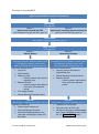
SavBAT2 User Manual User manual version created 9/12/2014 DISCLAIMER The material in this document is made available for general information only and on the understanding that the Commonwealth is not providing advice. Before relying on any material contained in this document, users should seek their own professional, independent advice about the use of in SavBAT2 and any of their entitlements or obligations that relate to any Commonwealth program. While reasonable efforts have been made to ensure the accuracy, correctness and reliability of the material contained in this document the Department1 does not guarantee the completeness or accuracy of the material provided. In no event shall the Department, its employees, officers, sub-contractors or third parties be liable to you for any damages, including without limitation, direct, indirect or consequential damages (including without limitation, damages for loss of profits, business interruption, or loss of information) arising out of the use or the inability to use this document or recommendations or information contained in this document whether based on warranty, contract or tort (including negligence) and whether or not advised of the possibility of such damages. 1 “Department” means the Commonwealth of Australia, as represented by the Department of the Environment or any other Commonwealth agency or body responsible for the administration of the SavBAT2 from time to time. © Commonwealth of Australia 2014 SavBAT2 User Manual, Page 2 Contents Disclaimer ............................................................................................................................. 2 1 About SavBAT2 ............................................................................................................. 5 1.1 Step-by-step use of SavBAT2 ................................................................................. 6 1.2 SavBAT2 offsets report ........................................................................................... 8 1.3 Abatement estimate ................................................................................................ 8 1.3.1 Differences due to use of a non-validated vegetation fuels type dataset .......... 9 1.3.2 Differences due to data used to inform the calculation processes .................... 9 1.4 2 Before you start: Data required from the user .............................................................. 12 2.1 Spatial Data ................................................................................................... 13 2.1.2 Baseline period and start date of the late dry season ..................................... 15 2.1.3 Global Warming Potential Values................................................................... 16 Project ID and Project Name .......................................................................... 16 2.2.2 Reporting year and start date of the late dry season ...................................... 16 2.2.3 Fuel usage details .......................................................................................... 16 Late dry season start date for hypothetical year ............................................. 17 2.3.2 Price per tonne of CO2-e ................................................................................ 17 Getting started: Using SavBAT2 .................................................................................. 17 3.1 SavBAT2 mapping functionality ............................................................................ 18 3.2 Abatement estimate .............................................................................................. 21 3.2.1 Printing of abatement estimate ...................................................................... 23 3.2.2 Export to CSV functionality ............................................................................ 23 SavBAT2 errors and problem solving .................................................................... 23 Results – SavBAT2 offsets report ................................................................................ 23 4.1 6 Data for abatement estimate ................................................................................. 17 2.3.1 3.3 5 Data for SavBAT2 offsets reports.......................................................................... 16 2.2.1 2.3 4 Data common to SavBAT2 offsets reports and abatement estimates .................... 13 2.1.1 2.2 3 Browser support .................................................................................................... 12 Record keeping - Information included in Excel file ............................................... 24 Results – Abatement estimate ..................................................................................... 24 5.1 Understanding the baseline fire characteristics ..................................................... 24 5.2 Analyse the abatement estimate result ................................................................. 25 5.3 Assess the projects’ target fire regime .................................................................. 26 SavBAT2 audit ............................................................................................................. 26 © Commonwealth of Australia 2014 SavBAT2 User Manual, Page 3 6.1 SavBAT2 authenticity............................................................................................ 27 7 Contact us.................................................................................................................... 28 8 Acknowledgements ...................................................................................................... 28 Appendix A - Procedure for generating project vegetation fuel type data for input to SavBAT2 from validated project vegetation fuel type mapping ............................................................ 29 Appendix B – SavBAT errors and problem-solving .............................................................. 37 © Commonwealth of Australia 2014 SavBAT2 User Manual, Page 4 1 ABOUT SAVBAT2 SavBAT2 automates geospatial and other calculations required to estimate greenhouse gas abatement for a project in accordance with the exposure draft of the Carbon Credits (Carbon Farming Initiative—Emissions Abatement through Savanna Fire Management) Methodology Determination 2015 (the methodology). The Department of the Environment and independent assessors quality assured SavBAT2 and found it is a true and correct translation of the methodology. SavBAT2 builds on SavBAT allowing users to: diagnose issues with user-created vegetation fuel type maps upload a project boundary and create a project vegetation fuel type dataset from a Government-supplied vegetation fuel type base map o Note: the vegetation fuel type base map is not certified as meeting the requirements of the methodology and cannot be submitted in an offsets report to the Clean Energy Regulator. The base map functionality is provided to assist proponents with estimates of abatement potential. estimate abatement potential for a hypothetical future year. o Note: this estimate uses the same processes and calculations as the SavBAT2 offsets report. However it does not account for fuel use, and makes assumptions that may result in estimates of potential abatement which are materially different from the abatement which is ultimately realized. See Abatement estimate, page 8, for more information on the abatement estimate functionality. Version 1.0 of SavBAT is applicable only to projects registered with an earlier methodology for savanna fire management made on 10 June 2013 (ComLaw ID F2013L01165). This earlier methodology applies only to areas receiving above 1000 mm average annual rainfall. SavBAT2 also supports projects in the low rainfall zone (between 600 and 1000 mm of average annual rainfall and less than 15 mm rainfall in the driest quarter) in addition to the high rainfall zone (above 1000 mm average annual rainfall). The methodology treats the two rainfall zones separately but combines the abatement estimates from each. Where a project spans both zones, the emissions and/or abatement are summed. Broadly, the methodological approaches for the two rainfall zones differ in the following ways: High rainfall: four vegetation fuel types are unique to this zone, the baseline period is 10 years Low rainfall: five vegetation fuel types are unique to this zone, the baseline period is 15 years. With the exception of the length of the baseline period, the calculation processes are the same for both rainfall zones. However, estimates from a project or potential project in the high rainfall zone calculated as per in the methodology will be materially different from those calculated as per the earlier methodology due to the following changes: 1. Fine fuel accumulation values is disaggregated into early dry season (EDS) and late dry season (LDS) © Commonwealth of Australia 2014 SavBAT2 User Manual, Page 5 2. Fire patchiness and burning efficiency is disaggregated into high and low rainfall values 3. Carbon content and nitrogen to carbon ratios is disaggregated by vegetation fuel type and fuel size class. Otherwise SavBAT2 calculates the abatement using the same logic and reference table values as SavBAT, including the same geospatial processes and calculations. SavBAT2 permits calculations for projects or potential projects where spatial data spans the two rainfall zones: SavBAT splits the data into two, with separate calculations for each rainfall zone combined to estimate the total emissions. GeoTIFF files that upload successfully in SavBAT are also correctly attributed and formatted for upload into SavBAT2. 1.1 Step-by-step use of SavBAT2 SavBAT2 is a simple web interface, consisting of six web pages that users step through sequentially, entering the required data and generating outputs to view or download on the last page. SavBAT2 does not require any user login. Users visit the website anonymously, entering and uploading their data, and receiving their output. No data is held by the website. Since SavBAT2 does not persistently store any of the user’s data, if the user leaves the web site or loses internet connectivity, they lose any data they have entered or uploaded and must start again. Users are responsible for their own document and records management. The steps for using SavBAT2 are described below. © Commonwealth of Australia 2014 SavBAT2 User Manual, Page 6 The steps to using SavBAT2... Agree to the SavBAT2 Terms and Conditions Upload Map (Two options) Option 1: Upload user-created GeoTIFF Option 2: Upload user-created project boundary file (See Vegetation fuel type GeoTIFF, page 14) (See Project boundary file, page 15) Confirm Map (See SavBAT2 mapping functionality, page 18) Select Process (Two options) Option 1: Offsets Report Option 2: Abatement Estimate Project Details Project Details (See Data common to SavBAT2 offsets reports and abatement estimates, page 13 and Data for SavBAT2 offsets reports, page 16) (See Data common to SavBAT2 offsets reports and abatement estimates, page 13 and Data for abatement estimate, page 17) Input user defined values: Project ID Project Name Reporting Year o Late dry season start date for reporting year Baseline Period o Late dry season start date for each year of the baseline period Fuel Usage Details Global Warming Potential Values Input user defined values: Late dry season start date for hypothetical year Global Warming Potential Values Baseline Period o Late dry season start date for each year of the baseline period Results Results (See Results – SavBAT2 offsets report, page 23) (See Results – Abatement estimate, page 24) Zipped file containing: Offsets report attachment Record-keeping information Excel file containing tables in the report but excluding the maps and their titles. © Commonwealth of Australia 2014 Displayed in a web page Price per tonne of CO2-e ($) All data on the page is downloadable as a Comma Separated Value (CSV) file (i.e. Export to CSV button) SavBAT2 User Manual, Page 7 1.2 SavBAT2 offsets report The zipped portable document format (.pdf) reports produced by SavBAT2 do not contain all of the content that project proponents are required to provide as part of their offsets submission to the Clean Energy Regulator or to keep as their records. The exact content of the outputs is detailed in Results – SavBAT2 offsets report from page 23, which also lists the additional data required to meet reporting and record-keeping requirements. SavBAT2: verifies that the area uploaded into SavBAT2 complies with the long-term average rainfall requirements of the methodology calculates the years since last burnt (YSLB) values for each pixel in an area uploaded into SavBAT2 calculates the fire scar area (A) in the EDS and the LDS periods for each vegetation fuel type class accepts pre-prepared data for fuel use accepts user-defined global warming potential values calculates net annual abatement required for offsets reporting and record keeping creates many of the maps required for offsets reporting and record keeping. SavBAT2 does not: provide mapping functionality that permits the user to create the vegetation fuel type map required by the methodology assess whether the vegetation fuels type map used by SavBAT2 to undertake the calculations has been validated in accordance with the methodology link to the National Greenhouse and Energy Reporting (NGER) legislation for the Fuel Usage and Global Warming Potential information (users should access NGER legislation independently for this information) calculate discounted net annual project abatement permit the use of seasonal fire maps that are not sourced from NAFI allow for baselines that start before the year 1992 in the lower rainfall region and 1995 in the higher rainfall region require (or allow) users to create accounts or log in provide a permanent document management or record management system for the files created by users output spatial datasets used in the calculation along with their associated metadata. These datasets are available for free download, pre-prepared and zipped, from the NAFI website (www.firenorth.org.au > More Tools > SavBAT data). To undertake the geospatial operations SavBAT2 will retrieve monthly fire maps developed and maintained on the North Australian Fire Information (NAFI) website www.firenorth.org.au. The data accessed is compliant with the requirements of the methodology for monthly and seasonal fire maps. 1.3 Abatement estimate Any abatement estimate will almost certainly be materially different from what abatement is ultimately realised due to: © Commonwealth of Australia 2014 SavBAT2 User Manual, Page 8 the use of a vegetation fuels type dataset that is not validated in accordance with the methodology, and/or the use of data to inform the calculation processes for the abatement estimate differing from that data used for the SavBAT2 offsets report estimates. The causes of these potential differences are explained in the next two sections. 1.3.1 Differences due to use of a non-validated vegetation fuels type dataset The use of a non-validated vegetation fuels type dataset will result in differences between the abatement estimate and what abatement is ultimately realised. This occurs when the user chooses to upload: a project boundary. In this case SavBAT2 creates a vegetation fuel type dataset from the vegetation fuel type base map, or a user-created GeoTIFF that has not been validated in accordance with the methodology. In both instances the completeness or accuracy of this map for any uploaded project boundary is unknown. 1.3.2 Differences due to data used to inform the calculation processes Abatement estimate calculations in SavBAT2 are informed by geospatial analysis when appropriate data are available (i.e. past data) and/or assumptions about the probabilities of vegetation fuel types burning in each fire season. SavBAT2 offsets report calculations are informed only by geospatial analysis resulting in differences between the abatement estimate and what abatement is ultimately realised. How these processes are used in the abatement estimate calculations is described below. © Commonwealth of Australia 2014 SavBAT2 User Manual, Page 9 Data used to inform calculation Area burnt by fire season and vegetation fuel type (ha) Table 12: Area burnt by YSLB (ha) SavBAT2 Table 14: Calculation type and the use of data derived using geospatial or probability processes SavBAT2 offsets report for reporting Abatement estimate for hypothetical year future year Geospatial: Uses the seasonal fire map Geospatial: Geospatial data is not and overlays this with the vegetation fuel available to populate this table so type map to derive actual area burnt in the probability based inputs are used. reporting year. Probability: Does not use historical fire Probability: Geospatial data is available to map data. Instead the percentage burnt populate this table so probability based each fire season is equally applied across inputs are not required or used. each vegetation fuel type in the area uploaded into SavBAT2. E.g. if a project has two vegetation fuel type: A: 200 ha; and B: 450 ha, then for the “cell” in the estimation table with 10% burnt EDS and 20% burnt LDS we would assume for the EDS, 20 ha of A was burnt and 45 ha of B, for the LDS, 40 ha of A and 90 ha of B. Geospatial: Uses the YSLB data for the previous year and overlays this data with: vegetation fuels type map, and seasonality map for the reporting year E.g. for 2013 the calculation must use the 2012 YSLB data. This is because fuel load in the area burnt in 2013 is a product of previous year’s fire activity, not the current year. The area burnt in 2013 data is used to compile the YSLB data for 2013 and this data is then be used for 2014 calculations. Probability: Geospatial data is available to populate this table so probability based inputs are not required or used. Geospatial: uses the most recent year of YSLB data and overlays this with the vegetation fuels type map to derive a table of YSBL by vegetation fuel type. Probability: Because it cannot be known which season each vegetation fuel type will burn in the future, the percentage burnt for each fire season is applied equally across each vegetation fuel type in the area uploaded into SavBAT2. Compared with the SavBAT2 offsets report process described to the left this process: uses the most recent year of YSLB data available and overlays this data with the vegetation fuels type map, then multiplies the resulting area by the percentage burnt for the EDS and LDS for the “cell” of the estimation results currently being calculated Below is a hypothetical example that illustrates the limitations of the abatement estimate. Hypothetical example: A high rainfall project has two vegetation fuel types: hSHH and hOFM, with areas of 100,000 and 10,000 ha respectively. In February 2016 the project proponent uses SavBAT2 to investigate abatement scenarios for the coming fire season. SavBAT2 overlays the project vegetation fuel type map with the available 2015 YSLB data to create Table i below. SavBAT2 then assigns area burnt by YSLB as per each combination of EDS and LDS percent area burnt from the results matrix. Table ii below gives a scenario from a results matrix where 10% of the area is burnt in the EDS and 20% in the LDS. Table iii demonstrates how Table i and ii are combined for this © Commonwealth of Australia 2014 SavBAT2 User Manual, Page 10 scenario. Using this approach SavBAT2 creates an equivalent of Table iii for each of the 66 combinations of EDS and LDS percent area burnt in the results matrix and uses this table to calculate potential abatement for each scenario (i.e. combination of EDS and LDS percentage area burnt). The following year (2017) the proponent creates a SavBAT2 offsets report for 2016. SavBAT2 uses the same 2015 YSLB data as in the previous year’s estimate; however the seasonal fire maps for 2015 have now been produced. SavBAT2 overlays the 2015 YSLB data with the vegetation fuel type map and the fire season map and determines the area burnt by YSLB (Table iv below). In this hypothetical example 33,000 ha burnt as it did in the abatement estimate example, with 11,000 ha in the EDS and 22,000 ha in the LDS. However the fire activity was proportionally higher in the hOFM than assumed in the earlier SavBAT2 estimate. Thus even though the total area burnt in each season was the same, the abatement calculation in the report will differ from the earlier abatement estimate because information is now available on where the activity has occurred and the associated vegetation fuel type influences emissions calculations. © Commonwealth of Australia 2014 SavBAT2 User Manual, Page 11 1.4 Browser support SavBAT2 is designed for a minimum support screen resolution of 1024 x 768 and for use with recent versions of the major browsers: Internet Explorer 9+, Chrome, FireFox 14+ and Safari. 2 BEFORE YOU START: DATA REQUIRED FROM THE USER If there is more than one CEA then the user must, externally from SavBAT2, separate the project area into two or more areas (e.g. separate CEAs’ are required for areas with a different end year for the baseline period). The user should then upload and process each vegetation fuel type dataset, along with the associated fuel use, separately. Running SavBAT2 multiple times for a single project, once with each CEA dataset, will give users © Commonwealth of Australia 2014 SavBAT2 User Manual, Page 12 multiple separate reports which will need to be manually combined by the project proponent in any offsets report submitted to the Clean Energy Regulator. Some data required to use SavBAT2 is common to both the SavBAT2 offsets report and the abatement estimate and some data is unique to each function. 2.1 Data common to SavBAT2 offsets reports and abatement estimates The data common to both the SavBAT2 offsets report and abatement estimates are spatial data as specified below, baseline periods, the start date of the LDS, and the Global Warming Potentials for methane and nitrous oxide. 2.1.1 Spatial Data The spatial data required by SavBAT2 for the project or potential project can be either a: A. User-created raster format vegetation fuel type map. To submit an offsets report to the Clean Energy Regulator this map must be validated in accordance with the methodology. This single dataset is termed the vegetation fuel type GeoTIFF; or B. Project boundary file. For option A SavBAT2 cannot assess whether the uploaded vegetation fuel type GeoTIFF has been validated in accordance with the methodology. Map validation occurs independently of use of SavBAT2. For option B SavBAT2 creates a vegetation fuel type dataset from the vegetation fuel type base map. This vegetation fuel type base map covers the entire high and low rainfall zones, is not certified as meeting the requirements of the methodology, and cannot be submitted in an offsets report to the Clean Energy Regulator. Use of the base map is only for hypothetical abatement estimates. © Commonwealth of Australia 2014 SavBAT2 User Manual, Page 13 2.1.1.1 Vegetation fuel type GeoTIFF Users choosing to use a vegetation fuel type GeoTIFF must, externally from SavBAT2, prepare a raster format vegetation fuel type map in a supported format2, projection and structure3, as defined in the table below. Image Format 8-bit palette GeoTIFF Georeferencing information Embedded in GeoTIFF tags Image File Extension .TIF or .TIFF Projection GDA_1994_Albers (EPSG:3577) Upload Format Single TIF file (no ancillary files required or allowed) Grid Size (Resolution) 250 m x 250 m Pixel values high rainfall zone Pixels must have the following values depicting the relevant vegetation fuel type: 0: Pixel is within the project area but contains an ineligible vegetation fuel type 1: hOFM (Open Forest Mixed) 2: hWMi (Woodland Mixed) 3: hWHu (Woodland Hummock) 4: hSHH (Shrubland Hummock) 255: NODATA (i.e. pixel is outside the project area) Pixel values low rainfall zone Pixels must have the following values depicting the relevant vegetation fuel type: 0: Pixel is within the project area but contains an ineligible vegetation fuel type 11: lWHu (Woodland with Hummock grass) 12: lWMi (Woodland with Mixed grass) 13: lWTu (Woodland with Tussock grass) 14: lOWM (Open Woodland, with Mixed grass) 15: lSHH (Shrubland (Heath) with Hummock grass) 255: NODATA (i.e. pixel is outside the project area) During testing of SavBAT2, the largest area for an uploaded vegetation fuel type GeoTIFF file was 7,395,819 ha. It is unknown if files with larger areas can be successfully uploaded by and calculated within SavBAT2. Appendix A describes the ESRI ArcGIS procedures for producing vegetation fuel type data in the format required for SavBAT2. As described earlier, a project may span the two rainfall zones, in which case each section of the user’s vegetation raster must only have the correct vegetation fuel types for that rainfall zone. Data showing the boundary of each zone is available from the Department’s website, and this data is formatted for GIS software. 2 A file format is a standard way that information is encoded for storage in a computer file, e.g. no ancillary files required or allowed 3 Structure refers to the use of only the allowable pixel values in the correct rainfall zone, i.e. data attribution © Commonwealth of Australia 2014 SavBAT2 User Manual, Page 14 The user must direct SavBAT2 to where the desired dataset is stored on their personal device using the Select File button. Upload of data stored from the internet is not supported. Notes on vegetation fuel type GeoTIFFs: 1. The methodology’s Explanatory Statement provides guidance on the steps involved to develop and validate a vegetation fuels type map required to create a compliant vegetation fuel type GeoTIFF 2. GeoTIFF files that upload successfully to SavBAT (i.e. existing high rainfall zone projects) are also correctly attributed and formatted for upload into SavBAT2. When these files are uploaded into: a. SavBAT2 calculations will be undertaken in accordance with the exposure draft of the Carbon Credits (Emissions Abatement through Savanna Fire Management) Methodology Determination 2015, or b. SavBAT calculations will be undertaken in accordance with the Carbon Farming (Reduction of Greenhouse Gas Emissions through Early Dry Season Savanna Burning—1.1) Methodology Determination 2013 available at http://www.comlaw.gov.au/Details/F2013L01165 2.1.1.2 Project boundary file Users choosing to use a project boundary file must, externally from SavBAT2, prepare a project boundary file in a supported format, projection and structure, as defined in the table below. File Formats Three options: zipped shapefile (ZIP: containing at least SHP, DBF, SHX and PRJ files) KML KMZ Projection shapefile in GDA94 Geographics or GDA_1994_Albers KML/KMZ only support WGS84 Geographics Allowed Features Must contain one or more polygons, each of which may be multi-part polygons. No attributes required or used (but these may be present) The user must direct SavBAT2 to where the desired dataset is stored on their personal device using the Select File button. Upload of data stored from the internet is not supported. 2.1.2 Baseline period and start date of the late dry season The baseline period is 10 years in the high rainfall zone and 15 years in the low rainfall zone. Periods must be in whole calendar years, corresponding to the requirements of the methodology and the fire maps provided by NAFI. The user must nominate the years for the baseline period. SavBAT2 identifies whether the user’s uploaded spatial data occupies the high or low rainfall zones or both, and presents appropriate baseline periods in the drop down option on the Project Details page. Where the © Commonwealth of Australia 2014 SavBAT2 User Manual, Page 15 uploaded spatial data for the project covers both rainfall zones, the baselines for the two zones will end synchronously such that the high rainfall zone baseline years will be the last 10 year period of the 15 year baseline for the low rainfall zone (e.g. for a baseline option of 1996-2010, the high rainfall zone baseline years will be 2001-2010 and the low rainfall zone baseline years will be 1996-2010). If there the project has two or more areas where the last year of the baseline period differ then the user must, externally from SavBAT2, separate the project area into two or more carbon estimation areas. The timing of the earliest available baseline years in SavBAT2 may be inconsistent with requirements of the methodology, and it is the user’s responsibility to select the appropriate baseline. The last year of the baseline period must be the same across all files and zones for spatial data uploaded into SavBAT2. For each year of the baseline period the LDS start dates will default to ‘1 Aug’ and be able to be set to ‘1 Jul,’ ‘1 Aug’ or ‘1 Sep’. Changing the LDS start date from the default is inconsistent with requirements of the methodology. 2.1.3 Global Warming Potential Values Global Warming Potential (GWP) values for methane (CH4) and nitrous oxide (N2O) are specified in Schedule 1 of the National Greenhouse and Energy Reporting (NGER) Measurement Determination in force at the time the offsets report is submitted or was required to be submitted to the Clean Energy Regulator, whichever is earlier. All versions of the NGER Measurement Determination can be accessed at http://www.comlaw.gov.au/. At the time this user manual version was published the GWP values were: CH4—21 N2O—310 Users must manually enter the appropriate GWP which will be validated as positive numbers by SavBAT2. 2.2 2.2.1 Data for SavBAT2 offsets reports Project ID and Project Name Both these fields are required. Project ID will be validated by SavBAT2 as a number of one or more characters with no spaces. Project name requires a single character only and there are no restrictions on characters or spaces. 2.2.2 Reporting year and start date of the late dry season The timing of the earliest available reporting year in SavBAT2 may be inconsistent with user obligations under the methodology and it is the user’s responsibility to select the appropriate reporting year. SavBAT2 allows only valid combinations of baseline and reporting years. The reporting year LDS start dates will default to ‘1 Aug’ and be able to be set to ‘1 Jul,’ ‘1 Aug’ or ‘1 Sep’. Changing the LDS start date from the default is inconsistent with requirements of the methodology. 2.2.3 Fuel usage details Fuel use may have zero, one or more rows, with a row for each fuel type used on the area uploaded into SavBAT2 during the reporting period. © Commonwealth of Australia 2014 SavBAT2 User Manual, Page 16 1. The fuel type name must match that specified in Schedule 1 of the National Greenhouse and Energy Reporting (NGER) Measurement Determination in force at the time the offsets report is submitted or was required to be submitted to the Clean Energy Regulator, whichever is earlier. This extends to the energy content factors and emission factors used to calculate the emissions from fuel use. All versions of the NGER Measurement Determination can be accessed at http://www.comlaw.gov.au/. 2. If a fuel usage row is entered (i.e. if any field in a row has data entered), all three fields of the row must be completed. It is recommended that the user records the fuel item number then the name of the fuel combusted, e.g. 56 Kerosene for use as fuel in an aircraft. 3. The user must, externally from SavBAT2, calculate the emissions from fuel use in accordance with the requirements of the NGER Measurement Determination. Volume Used and Emissions from Fuel Use will be validated by SavBAT2 as positive numbers. 2.3 Data for abatement estimate 2.3.1 Late dry season start date for hypothetical year The hypothetical reporting year LDS start dates will default to 1 Aug and be able to be set to 1 Jul, 1 Aug or 1 Sep. The start date of the LDS for each year of the reporting and baseline period may be published by the Government for various regions across north Australia. If the Government does not publish a date the default start date is 1 August. It is unlikely that the Government would publish a LDS start date for a hypothetical (i.e. future year). Users may choose to select a LDS start date based on the historical LDS start dates for the area. 2.3.2 Price per tonne of CO2-e The user can, by pressing the button Gross Value activate functionality where they can input their estimate of the price per tonne of CO2-e. The e $ value for the estimated abatement when multiplied by this value is displayed. 3 GETTING STARTED: USING SAVBAT2 SavBAT2 pages are set up for ease of navigation with buttons at the base of each page, allowing users to navigate backwards and forwards at any point before the calculation has been initiated. The user must have uploaded a valid file or populated required cells with valid data to progress through the pages using the Next or Calculate buttons. Note that when using SavBAT2, the user should navigate using the buttons provided at the bottom of each page; do not use the browser’s Back or Forward buttons to navigate. SavBAT2 assists users through drop down menus for standard values where they occur. Cells or drop down menus can be selected either by tabbing or selecting the cell using the cursor. Cells are colour coding or shaded to help users: © Commonwealth of Australia 2014 SavBAT2 User Manual, Page 17 White: Cell requires value but user has not yet tabbed through or clicked on the cell Green: Data passes validation. Note that this does not mean that the data is correct for the user’s project area uploaded into SavBAT2 Red: User has input invalid data or selected a cell without populating the cell. Until all required cells have been populated with valid data, the Next or Calculate button will be disabled. The below image shows standard features in the Offsets Report - Project Details page. The Abatement Estimate has the same features but requires less data. Red = Fails validation Green = Passes validation Red = Tabbed cell requires data and has been left unpopulated Drop down menu for standard values Adds a new row for fuel Red = User has added a row but not populated any cells so all cells in row coloured Deletes unrequired row White = Cell requires value but user has not yet tabbed through or clicked on the cell 3.1 Calculate button disabled due to invalid values and/or unpopulated cells SavBAT2 mapping functionality SavBAT2 has a simple map page which displays the uploaded (or clipped) vegetation data to the user, highlighting errors such as invalid pixel values (i.e. invalid vegetation fuel types) or pixels extending beyond their valid rainfall zone. It also allows the user to confirm that the numerical indexing within the input layer matches the SavBAT2 specifications (e.g. the pixels that should be attributed as 2 are not attributed as 4). © Commonwealth of Australia 2014 SavBAT2 User Manual, Page 18 A user who imports a vegetation fuel type GeoTIFF or uploads a project boundary file that conforms to the supported format will be presented with a non-editable image of the vegetation fuel type GeoTIFF. The image will have pan and zoom functionality and display the following: Spatial data file name. All the eligible vegetation fuel type pixels in the spatial data and colour codes for these pixels with a colour that is unique to each eligible vegetation type. The user can turn the vegetation fuel type layer on and off to assist with error diagnosis. This layer is named the Vegetation raster. Key to the codes on the page. Where vegetation pixels are attributed incorrectly or where a vegetation pixel is attributed as an eligible vegetation fuel type but falls partly or wholly outside of the relative rainfall zone these pixels will be colour coded red. When the cursor is positioned over any pixel and the left mouse button clicked, the attribution data for that pixel will be shown, allowing the user to diagnose vegetation fuel type GeoTIFF errors and confirm that the attribution for non-error pixels is correct. A line of the coastline (this is named the Base Layer) and both rainfall boundaries, including buffered boundaries. The user can turn the rainfall boundaries on and off to assist with error diagnosis but cannot do this for the Base Layer. o Note: each rainfall zone has a buffer of one pixel (250 m). This buffer accounts for the fact that when clipping the correctly geo-referenced vegetation fuel type GeoTIFF with the polygon rainfall boundary border, pixels are likely to still overlap the polygon by up to one pixel width, depending on the software employed by the user and the options selected to do the clip. Due to the nature of polygons, the use of this buffer does not bias the estimate because the area of additional land beyond the boundary that is included is, on average, equal to area of land omitted where the activity is permitted and carried out. This means that on average, the area of land considered will closely conform to the unbuffered rainfall boundary. Where the two rainfall zones meet there is a 500 m zone where pixels may be legitimately attributed as high or low rainfall vegetation fuels types. The latitude and longitude, Albers easting and northing, of the cursor position on the map. Grid north. A scale. A location map (MiniMap) showing the relative position of the screen area to the coastline and the rainfall boundaries. The user can hide or unhide the MiniMap. © Commonwealth of Australia 2014 SavBAT2 User Manual, Page 19 Invalid pixels shown in red Cursor Rainfall boundaries Value of selected pixel Next button disabled User can also double click with cursor to see pixel value above pixel Map layers Next button disabled Where there are many invalid pixels it may assist diagnosis to turn off the invalid vegetation pixel layer as below. © Commonwealth of Australia 2014 SavBAT2 User Manual, Page 20 Invalid pixel layer turned off to assist in diagnosis Current screen extent shown on MiniMap Next button disabled due to invalid pixels The user will be prompted to confirm that the vegetation fuel type map is correct (by pressing the Next button) before proceeding if the following criteria are met: all vegetation fuel type pixels are attributed correctly (vegetation fuel type GeoTIFF only) all eligible vegetation fuel type pixels are located wholly within the relevant rainfall zone (vegetation fuel type GeoTIFF only). If these criteria are not met then SavBAT2 will not be able to complete calculations until spatial data is correctly attributed and the Next button will be disabled. 3.2 Abatement estimate Once the user has progressed to the project details page and entered all required data the Calculate button will become active. The output from the abatement estimate calculation is an onscreen display of estimated emissions in tonnes of CO2-e and its estimated dollar ($) value. Guidance on how to interpret the results is given in Results – Abatement estimate, page 24. © Commonwealth of Australia 2014 SavBAT2 User Manual, Page 21 Exports all data on the page at present to a CSV file Price per tonne is editable if user selects the gross value option Cells display abatement in tonnes of CO2-e or gross value depending on the display option chosen by the user Display shows information about the abatement estimate The initial view of the calculation results is tonnes of CO2-e for scenarios of percentage of the area uploaded into SavBAT2 burnt in the EDS and LDS in 10% increments. The ‘% of project area burnt’ by fire season is the fire scar area as a percentage of the area uploaded into SavBAT2, not the fire scar area multiplied by patchiness as a percentage of the area uploaded into SavBAT2. The right side of the page displays information about the area uploaded into SavBAT2 and the information used to inform the abatement estimate. This information and the results in tonnes of CO2-e are static and do not change. If the user wishes to change any of the information about the area uploaded into SavBAT2 or the abatement estimate, other than the price per tonne, they will need to run another simulation. © Commonwealth of Australia 2014 SavBAT2 User Manual, Page 22 As well as the tonnes of CO2-e, the user can, by pressing the button Gross Value, activate functionality where they can populate the price per tonne cell with a value of interest to them. The display then shows the dollar value for the estimated abatement when multiplied by this value. Adding or changing the value in this field dynamically updates the data displayed in the table cells (this is done within the browser and is very quick). 3.2.1 Printing of abatement estimate SavBAT2 does not have a print function. Users can print the abatement estimate by using the print screen function on their computer (which may be named ‘Prnt Scrn’ on some keyboards). The user may need to resize and/or zoom the internet application they are using so that all results and information are visible. Users with Microsoft Windows operating systems can also use the ‘Snipping Tool’ program in the Accessories program list to take screen shots. Alternatively users can export the results to a CSV file and format the output to their own requirements. 3.2.2 Export to CSV functionality In addition to the screen display of this data, the Export to CSV button can be used to download a comma separated values (.csv) file containing the data displayed on the page at the time the button is pressed (i.e. either estimated emissions in tonnes of CO2-e or dollars). The CSV output does not contain any formulae or functionality. Saving both the tonnes of CO2-e and gross value requires exporting twice. If the user wishes to explore the effect of different prices for the same abatement estimate then the gross value results can be exported multiple times for the same abatement calculation. 3.3 SavBAT2 errors and problem solving Appendix B describes the SavBAT2 error messages and procedures for addressing the errors. 4 RESULTS – SAVBAT2 OFFSETS REPORT For the offsets report option, SavBAT2 produces two separate PDF reports and an Excel file which are zipped and provided to the user for download. The three outputs are: Offsets report attachment o File Name Attachment1_Calculations_And_Maps_For_Project_Offset_Report.pdf Record-keeping information: o File Name - Calculations_And_Maps_For_Project_Record_Keeping.pdf Excel file: o File Name - Calculations_And_Maps_For_Project_Record_Keeping.xlsx Note that where an area uploaded into SavBAT2 spans low and high rainfall zones, the results will be integrated within these reports. The reports and files produced by SavBAT2 do not contain all of the content that project proponents need to provide as part of their offsets report submission to the Clean Energy Regulator or keep as their records. The SavBAT2 offsets report attachment contains the © Commonwealth of Australia 2014 SavBAT2 User Manual, Page 23 necessary maps and calculation result for net annual abatement and the project proponent will need to manually create their offsets report. 4.1 Record keeping - Information included in Excel file The report tables are also provided in an Excel format file based on the Project Record Keeping report (since it contains the superset of tables), including all tables in that report but excluding the maps and their titles. The tables are presented on separate spreadsheet pages for each year of the baseline, the reporting year and the abatement results. The file does not include any formulae. RESULTS – ABATEMENT ESTIMATE 5 Interpreting the results from an abatement estimate involves: 1. Understanding the baseline fire characteristics. 2. Analysing the abatement estimate result. 3. Assessing the projects’ target fire regime. 5.1 Understanding the baseline fire characteristics Determine the project’s fire characteristics in the baseline, primarily percentage area burnt in EDS and LDS. By developing an understanding of these characteristics and applying their knowledge of the project area the user can begin to understand, not only what the average characteristics are, but also how variable fire has been during the baseline. This knowledge could then be drawn upon when considering the risks imposed by natural variability on any target(s) a project may choose to set. To explore the baseline fire characteristics the user would: i. ii. Run a SavBAT2 offsets report for the project where the baseline years match those of interest Use the CSV outputs from the SavBAT2 offsets report: a. for each year of the project calculate the average % area burnt for all vegetation fuels types in EDS and LDS from Table 11 such as in the hypothetical example below b. examine the annual variability in these user calculated values © Commonwealth of Australia 2014 SavBAT2 User Manual, Page 24 EDS LDS 1 2 3 4 5 6 7 8 9 10 583,655 198,290 159,388 977,646 413,647 103,625 434,147 432,042 920,241 195,174 98,612 127,546 346,256 296,173 985,382 274,002 863,473 808,346 390,954 357,487 Area (Ha) for Project Region (sum of vegetation fuel types from Table A) 2,000,000 2,000,000 2,000,000 2,000,000 2,000,000 2,000,000 2,000,000 2,000,000 2,000,000 2,000,000 Average (%) 441,786 454,823 2,000,000 Baseline year Average area burnt in baseline (ha) (sum of vegetation fuel types from Table 11) % of project area burnt EDS LDS 29% 10% 8% 49% 21% 5% 22% 22% 46% 10% 5% 6% 17% 15% 49% 14% 43% 40% 20% 18% 22% 23% It is anticipated that future versions of SavBAT will provide this type of information along with the abatement estimate output. 5.2 Analyse the abatement estimate result Using the knowledge about the baseline trace the average LDS % burnt (yellow arrow) to where it meets the average EDS % burnt (blue arrow). Users make their own extrapolations regarding abatement for areas burnt between the 10% increments. © Commonwealth of Australia 2014 SavBAT2 User Manual, Page 25 5.3 Assess the projects’ target fire regime Assess the abatement impact of the projects target EDS and LDS % area burnt by tracing the target LDS % burnt to where it meets the target EDS % burnt. The layout allows the user to assess the impact of adverse outcomes such as where break even is when the user meets the LDS target but where the LDS exceeds the target (use the gross value function and the price per tonne cell with a value of interest). 6 SAVBAT2 AUDIT Audit reports, prepared by a registered category two or three greenhouse and energy auditor, provide reasonable assurance that the user’s project complies with the Eligible Offsets Project declaration, methodology and relevant legislative requirements for the reporting period. Information assessed by an auditor can include the location and area of the project, evidence to support legal right to undertake the project, monitoring data, the details of abatement calculations and record keeping. The methodology allows project proponents to undertake some required geospatial and other calculations either manually or by using SavBAT2. Use of SavBAT2 simplifies the reporting and record-keeping requirements but it is not mandatory. Information on auditing is available on the Clean Energy Regulator website: http://www.cleanenergyregulator.gov.au. The auditor may wish to confirm the authenticity of SavBAT2 and the calculations submitted by a project as described in the following section. © Commonwealth of Australia 2014 SavBAT2 User Manual, Page 26 6.1 SavBAT2 authenticity The Department of the Environment and independent assessors have undertaken quality assurance testing of SavBAT2 and found it is a true and correct translation of the methodology. To support auditing of the web site and its calculations, a single MD5 checksum value (e.g. 176DADE867B804D645FF979EA01F2F0D4) will be computed for the two key files used to compute the emissions outputs, the uploaded raster vegetation fuel type dataset and SavBAT2 code that calculates the emissions (and all interim values). This will be done as follows: a) Each time the process is run by a user, an MD5 checksum value will be computed for SavBAT2 code and a separate MD5 checksum will be computed for the user’s vegetation fuel type dataset as uploaded. b) These two hexadecimal values will be added to produce the final hexadecimal checksum value. c) The checksum value will be included in the output reports. This allows an audit of the output to be undertaken at any time, by recomputing the file checksums, adding them and comparing the result to the value included in the report. SavBAT2 automatically adds the two component values. © Commonwealth of Australia 2014 SavBAT2 User Manual, Page 27 7 CONTACT US To contact the Australian Government for any reason regarding SavBAT2, please contact the Department of the Environment at [email protected] or by phoning 1800 057 590. 8 ACKNOWLEDGEMENTS Version 1.0 of the Carbon Farming Initiative (CFI) Savanna Burning Abatement Tool (SavBAT) was funded through a grant to Cooperative Research Centre for Spatial Information and Bushfires NT under the Research and Development Stream of the Indigenous Carbon Farming Fund. This Fund aimed to encourage Indigenous participation in the CFI by supporting the development and accelerating the uptake of CFI methodologies for abatement activities likely to have high Indigenous participation. SavBAT2 builds on the success of SavBAT. Development and hosting of SavBAT2 is funded by the Department of the Environment, and made possible by the following organisations: The North Australian Fire Information service (NAFI) allows SavBAT2 to access necessary map data; The Indigenous Land Corporation and Latitude Forest Services assisted with the design and development of the procedure for preparing project data on vegetation fuel types for input to SavBAT2 (Attachment A); Darwin Centre for Bushfire Research (DCBR) at Charles Darwin University contributed to the development and testing of SavBAT2 and this manual; Auricht projects, Charles Darwin University and Darwin Herbarium created the base map of vegetation fuel types; The Clean Energy Regulator for advice on auditing; Spatial Vision designed and developed the web tool. © Commonwealth of Australia 2014 SavBAT2 User Manual, Page 28 APPENDIX A - PROCEDURE FOR GENERATING PROJECT VEGETATION FUEL TYPE DATA FOR INPUT TO SAVBAT2 FROM VALIDATED PROJECT VEGETATION FUEL TYPE MAPPING This appendix describes how to produce project vegetation fuel type data in the required format for input to SavBAT2. All other formats will be rejected by SavBAT2. The definition of the required format is as follows: Image Format 8-bit palette GeoTIFF Georeferencing information Embedded in GeoTIFF tags Image File Extension .TIF or .TIFF Projection GDA_1994_Albers (EPSG:3577) Upload Format Single TIF file (no ancillary files required or allowed) Grid Size (Resolution) 250 m x 250 m Pixel values high rainfall zone Pixels must have the following values depicting the relevant vegetation fuel type: 0: Pixel is within the project area but contains an ineligible vegetation fuel type 1: hOFM (Open Forest Mixed) 2: hWMi (Woodland Mixed) 3: hWHu (Woodland Hummock) 4: hSHH (Shrubland Hummock) 255: NODATA (i.e. pixel is outside the project area) Pixel values low rainfall zone Pixels must have the following values depicting the relevant vegetation fuel type: 0: Pixel is within the project area but contains an ineligible vegetation fuel type 11: lWHu (Woodland with Hummock grass) 12: lWMi (Woodland with Mixed grass) 13: lWTu (Woodland with Tussock grass) 14: lOWM (Open Woodland, with Mixed grass) 15: lSHH (Shrubland (Heath) with Hummock grass) 255: NODATA (i.e. pixel is outside the project area) For the operation of eligible projects the methodology requires that a map of vegetation fuel type must: a) Be in raster format with a maximum pixel size of 250 m x 250 m. b) Assign a vegetation fuel type to each pixel that represents a part of the project area, according to the vegetation fuel type specified in Schedule 1. (The high and low rainfall zones have vegetation fuels types unique to each zone and SavBAT2 checks that each zone is correctly attributed). c) Be based on mapping products of topographical and landscape features such as landform, substrate, slope, elevation, projected foliage cover, persistent greenness, or a satellite-derived vegetation index. d) Be validated in accordance with section 3.4 using validation data collected not more than three years before project commencement. © Commonwealth of Australia 2014 SavBAT2 User Manual, Page 29 The procedure described here assumes: Vegetation fuel type map data have been created or derived by the user and saved as a shapefile. The vegetation fuel type data has been clipped to the project boundary and the relevant rainfall zone boundary(s). for the production of a SavBAT2 offsets report attachment to be submitted to the Clean Energy Regulator as part of the projects offsets report, the vegetation fuel type map has been created and validated according to the methodology. ESRI ArcGIS Desktop is being used as the GIS application. As part of ArcGIS Desktop, ArcMap is used for data manipulation whereas ArcGIS Explorer can be used for viewing vegetation fuel type layers. Users can employ other GIS applications if they wish, however the steps below will not apply. Freeware GIS applications include QGIS (http://www.qgis.org/en/site/) and MapWindow (http://www.mapwindow.org/) – these can also be used to view vegetation fuel type layers. Some data manipulation in GIS freeware is available; this usually requires the user to download relevant add-ons. Steps 1. Open a new ArcGIS for Desktop session using the ArcMap program. Do not have any layers open/added. 2. Open Data Frame Properties (see image below) and ensure the data frame is in a GDA_1994_Albers (ESPG:3577) projection, as defined in the table below. © Commonwealth of Australia 2014 SavBAT2 User Manual, Page 30 PROJCS["GDA94 / Australian Albers", Geographic Coordinate System: “GCS_GDA_1994” or “GDA94”] o DATUM["Geocentric Datum of Australia 1994" SPHEROID["GRS 1980", 6378137.0, 298.257222101, AUTHORITY["EPSG","7019"]], TOWGS84[0.0, 0.0, 0.0, 0.0, 0.0, 0.0, 0.0], AUTHORITY["EPSG","6283"]], o PRIMEM["Greenwich", 0.0, AUTHORITY["EPSG","8901"]], o UNIT["degree", 0.017453292519943295], o AXIS["Geodetic longitude", EAST], o AXIS["Geodetic latitude", NORTH], o AUTHORITY["EPSG","4283"]], PROJECTION["Albers Equal Area", o AUTHORITY["EPSG","9822"]], PARAMETER["central_meridian", 132.0], PARAMETER["latitude_of_origin", 0.0], PARAMETER["standard_parallel_1", -18.0], PARAMETER["false_easting", 0.0], PARAMETER["false_northing", 0.0], PARAMETER["standard_parallel_2", -36.0], UNIT["metre", 1.0], AXIS["Easting", EAST], AXIS["Northing", NORTH], AUTHORITY["EPSG","3577"]] 3. Add the vegetation fuel type shapefile to the data frame. 4. Check the mapping extent and edit or clip, using the Clip function under Raster Processing: a) Clip using the project boundary b) Clip using the appropriate rainfall region boundary (high rainfall or low rainfall zones) if the user’s project is on the coast or adjacent to the boundary between rainfall zones. c) If the user’s project area crosses the boundary between the two rainfall zones, it is suggested that the user does not merge the maps in shapefile format, but later in the process when they are both in raster format (see step 6). 5. Check the properties of the file, ensuring the data is in GDA_1994_Albers (ESPG:3577) (in ArcMap: GDA 1994 Australia Albers). If not, re-project the file using the Project tool. © Commonwealth of Australia 2014 SavBAT2 User Manual, Page 31 6. Classify the vegetation fuel type data according to the SavBAT2 vegetation fuel type pixel values. a) Add an integer field (e.g. ‘SavBAT2_Fuel_Type’) to the shapefile attribute table and use the Field Calculator (right mouse click on heading of the new field) to attribute the new field with values 0, 1, 2, 3, 4, 11, 12, 13, 14, 15. To avoid common errors ensure that before conversion: Only values 0, 1, 2, 3, 4, are used in the high rainfall zone. Only values 0, 11, 12, 13, 14, 15 are used in the low rainfall zone. Ineligible vegetation types in the project area are set to zero. not to 255, 256 or any other value prior to conversion. The vegetation fuel type data is clipped to the project boundary. The vegetation fuel type data is clipped to the rainfall map(s). Note: SavBAT2 has buffered the rainfall region boundaries by one pixel [250 m] to allow for the raster representation of vector mapping; however, if a pixel extends over the buffered rainfall zone boundary it will be rejected by SavBAT2. It is therefore worthwhile zooming in to the project boundary, overlaying the buffered rainfall zone boundaries, and checking the mapping extent). 7. Convert the feature dataset to a raster using the Feature to Raster tool: © Commonwealth of Australia 2014 SavBAT2 User Manual, Page 32 a) ‘Field’ must be the new integer field (e.g. ‘SavBAT2_ Fuel_Type’). b) Output Raster: specify the file extension .tif and include this extension in the file name. c) Cell size is 250.0. SavBAT2 requires a 250 m resolution. Grid size can be changed using the Resample tool under Raster Processing. Note: adding the ‘.0’ to ‘250’ (i.e. ‘250.0’) helps minimise problems that may occur during this conversion process. If the user is having a problem with the pixel size, they may find it helpful to install the open source GDAL utility program. The user can use the GDALINFO command to check and correct rasters. 8. After the Feature to Raster conversion process is complete add the raster layer to the data frame, if it is not set to do so automatically. 9. Double click on the raster dataset. Under Properties > symbology - classify as ‘Unique Values’ a) If asked ‘do you want to create unique values?’ > yes b) Check the raster values are the correct integer values, i.e. 0,1,2….15 only In the Raster Information, the NoData Value will most likely be blank, it doesn’t matter if it is or not. The user will have to undertake a further conversion of the file to make the NoData values = 255, see step 9. c) Check the Raster Information: Properties > Source > Raster Information Number of bands : 1 Cellsize (x,y): 250, 250. © Commonwealth of Australia 2014 SavBAT2 User Manual, Page 33 o Format: TIFF o if incorrect: the user forgot to put .tif on the end of the output file name Pixel Type: unsigned integer o if incorrect: the user used a default value or typed in the wrong value in the feature to raster conversion if the pixel Type is incorrect: then the user has either used the wrong field in the feature to raster conversion or has calculated a wrong value in the ‘SavBAT2_ Fuel_Type’ field. Pixel Depth: 8 Bit o if the pixel Depth are incorrect: then the user has either used the wrong field in the feature to raster conversion or has calculated a wrong value in the ‘SavBAT2_ Fuel_Type’ field. If any of the above are incorrect, delete the file, make the change(s) suggested above, and recreate the raster layer. 10. There are two methods to create the final raster; if one method doesn’t work then try the other: a) Use Copy Raster tool: Data management tools > Raster > Raster Dataset > Copy Raster add ‘.tif’ extension define ‘no data’ = 255 Pixel type = 8 bit unsigned b) Right click on the raster: Data > Export Data Cell Size: 250 and 250 NoData as: 255 Format: TIFF The user can use LZW compression if they wish. © Commonwealth of Australia 2014 SavBAT2 User Manual, Page 34 11. Check the properties and values of the file as per the Verification section below. 12. Save the vegetation fuel type GeoTIFF in a folder for use as input in SavBAT2. 13. Save a copy of the vegetation fuel type GeoTIFF and raw map for archiving purposes in accordance with the methodology. 14. It is recommended the user does backup all related data on a separate IT network or some other off-site storage facility. Verification The points below are not required to make data ready for use in SavBAT2, but can help in confirming the format and features of existing *.tif vegetation layers, and making some fixes to existing data. If the user wishes to view and verify an existing *.tif vegetation fuel type layer, they should use a GIS application to do so, such as ArcMap as used in the steps above, or ArcGIS Explorer, as included in the ESRI ArcGIS platform. Freeware and other GIS software will also work provided the user has an understanding of the software functionality and tools. The below examples use both ArcGIS Explorer and ArcMap to work through the viewing and verification process. The verification process can be used, for example, to check for correct vegetation fuel type attribution across the area uploaded into SavBAT2, and more generally to confirm that the vegetation fuel type layer has been created correctly for use in SavBAT2. 1. In ArcGIS Explorer, display the vegetation fuel type layer by using the Add Content > Raster Data options. Find the vegetation fuel type layer in the directory box that appears and select and open. The visual representation of the layer will appear in the data frame on the right, and the contents panel on the left will show the pixel values that correspond to the raster layer. These pixel values reflect the vegetation type, dependent on rainfall area, as detailed in the first table of Appendix A. © Commonwealth of Australia 2014 SavBAT2 User Manual, Page 35 If displaying the vegetation layer in ArcMap, choose the Add Data option and navigate to the layer saved in the directory, then open. The screen display will be very similar to the ArcGIS Explorer display. Use the information button option to click on and find out more information about individual pixels, or refer to the left hand panel for pixel values and associated colours. 2. To verify the coordinate system and projection, and that it complies with SavBAT2 requirements (GDA_1994_Albers), open layer properties in ArcGIS Explorer by rightclicking the vegetation layer title in the left hand contents panel. Under the Source Data tab it will list data type (raster) and the coordinate system. If this coordinate system is different to GDA_1994_Albers, please use ArcMap/another GIS with data manipulation functionality to re-project the layer (see step 5 above). Check the properties after re-projection to ensure the process has worked. 3. If needing to reclassify numerical pixel values of the vegetation layer to those required by SavBAT (see first table of Appendix A for pixel values and corresponding vegetation types), use the Reclassify or Reclass by Table tools in ArcMap, under Spatial Analyst. © Commonwealth of Australia 2014 SavBAT2 User Manual, Page 36 APPENDIX B – SAVBAT ERRORS AND PROBLEM-SOLVING There are three issue types in the below table, these are: Error Message: SavBAT provides an error message to help the user resolve the issue. Error: A SavBAT2 function is not available because the user has not entered required data or entered invalid data. Information Message: Not an error, for information only. SavBAT2 page Issue Solution Any Error Message: “Unable to connect to server, please check your internet connection.” This is due to a loss of internet connection – check your networking connection, networking settings, the cables to your modem, etc. Welcome Error: ‘I agree and next’ button not functioning This could occur if the SavBAT2 website does not load fully and correctly and could be caused by poor network connectivity. It could also be caused by using an unsupported browser type or version (see page 12 for information about supported browsers). If you believe the problem may have been network related, once your network is working correctly, press the browser refresh button to try reloading the SavBAT2 website. Upload map Error: ‘Next’ button not functioning No valid spatial file has been uploaded by the user – upload a valid spatial file. Upload map Error Message: “Error SavBAT will not be able to complete calculations until the vegetation pixels are attributed correctly or all eligible vegetation pixels are located wholly within the relevant rainfall zone. This must be completed by modifying the Veg GeoTIFF externally to SavBAT” The uploaded GeoTIFF file is not attributed correctly or some eligible vegetation pixels are outside the relevant rainfall zone. Externally to SavBAT2, modify the file to comply with the requirements in Vegetation fuel type GeoTIFF, page 14 and upload it again. Upload map Error Message: "Dataset is completely outside the rainfall region." The uploaded GeoTIFF or boundary file is correctly attributed but entirely out of the rainfall regions. Externally to SavBAT2, modify the file to comply with the requirements in Vegetation fuel type GeoTIFF, page 14. Upload map Error Message: "The uploaded file is not valid, please try again" The uploaded GeoTIFF or boundary file is not in the supported format, projection and structure. Externally to SavBAT2, modify the file to comply with the requirements in Vegetation fuel type GeoTIFF, page 14 or Project boundary file, page 15. © Commonwealth of Australia 2014 SavBAT2 User Manual, Page 37 SavBAT2 page Issue Solution Upload map Error Message: "Projection must be <xxx>” The uploaded GeoTIFF file is not in the supported projection (where <xxx> would be replaced by words within this list: EPSG:3577,GDA, 94, Albers). Externally to SavBAT2, modify the file to comply with the requirements in Vegetation fuel type GeoTIFF, page 14 Upload map Error Message: "Grid size (m) must be 250 x 250" The uploaded GeoTIFF file is not set to the required grid size. Externally to SavBAT2, modify the file to comply with the requirements in Vegetation fuel type GeoTIFF, page 14. More help is available in Appendix A, page 29. Upload map Error Message: "Image Format must be a single band GeoTIFF" The uploaded GeoTIFF file is not in the required format. Externally to SavBAT2, modify the file to comply with the requirements in Vegetation fuel type GeoTIFF, page 14. More help is available in Appendix A, page 29. Upload map Error Message: "Image data type cannot be <xxx>. It must be a 8-bit palette GeoTIFF" The uploaded GeoTIFF file is not in the required format (where <xxx> is replaced with the image type SavBAT2 determined). Externally to SavBAT2 modify the file to comply with the requirements in Vegetation fuel type GeoTIFF, page 14. More help is available in Appendix A, page 29. Upload map Error Message: "Image data type cannot be 1 bit. It must be a 8-bit palette GeoTIFF" The uploaded GeoTIFF file is not in the required format. Externally to SavBAT2 modify the file to comply with the requirements in Vegetation fuel type GeoTIFF, page 14. More help is available in Appendix A, page 29. Upload map Error Message: "Fail to get GeoTransform Metadata'" The uploaded GeoTIFF or project boundary file may be in the supported format, projection and/or structure; however when SavBAT2 tries to set the GIS dataset metadata (which defines its projection) an unspecified error occurs in SavBAT2. This is unlikely to occur – try the process again and if the problem persists contact the Department of the Environment. Upload Map Error Message: “Unexpected Error: Upload failure reason unknown. Please select the file and try again.” The upload of the GeoTIFF or project boundary file fails for unknown reason(s). -Check the map file to ensure it conforms to spatial data requirements, and, for project boundary files, that the file does not contain duplicate polygons. Upload map Error Message: "The uploaded shapefile has no projection file." The uploaded project boundary ZIP file folder contains the SHP, SHX and DBF files but no PRJ file. – Externally to SavBAT2, modify the file to comply with the requirements in Project boundary file, page 15. Upload map Error Message: "The uploaded zip file does not contain a valid shapefile." The uploaded project boundary ZIP file is not in the supported format, projection and structure. Externally to SavBAT2, modify the file to comply with the requirements in Project boundary file, page 15. © Commonwealth of Australia 2014 SavBAT2 User Manual, Page 38 SavBAT2 page Issue Solution Confirm map Error: ‘Next’ button not functioning This will generally indicate that the uploaded GeoTIFF or map boundary files were not valid. There are numerous possible reasons for this see error message on the Confirm Map page for reason. Confirm Map Error Message: "Invalid pixel value is found. Value must be in list <xxx>" For uploaded GeoTIFF, pixels are attributed incorrectly (where <xxx> would be the list of valid pixel values for the rainfall region(s) covered by the dataset eg. 0, 1, 2, 3, 4, 255). These invalid pixels are colour-coded in red on the Confirm Map page. Use the SavBAT2 mapping functionality to identify the invalid pixel and externally to SavBAT2 modify the file to comply with the requirements in Vegetation fuel type GeoTIFF, page 14. Confirm Map Information Message: "All pixels in the vegetation raster are valid. The raster is entirely within the Low rainfall region." Not an error, information only. Confirm Map Information Message: "All pixels in the vegetation raster are valid. The raster is entirely within the High rainfall region." Not an error, information only. Confirm Map Information Message: "All pixels in the vegetation raster are valid. The raster is located in both rainfall regions." Not an error, information only. Confirm Map Error Message: "<xxx> high rainfall vegetation pixels are incorrectly located outside the high rainfall region.' For uploaded GeoTIFF, pixels are attributed correctly but one or more pixels attributed as uniquely high rainfall (i.e. 1, 2, 3, 4) are located outside of the high rainfall zone (where <xxx> is replaced by the number of pixels in error). – These misplaced pixels are colour-coded in red on the Confirm Map page. Use the SavBAT2 mapping functionality to identify the invalid pixel and, externally to SavBAT2, modify the file to comply with the requirements in Vegetation fuel type GeoTIFF, page 14. Confirm Map Error Message: "<xxx> low rainfall vegetation pixels are incorrectly located outside the low rainfall region For uploaded GeoTIFF, pixels are attributed correctly but one or more pixels attributed as uniquely low rainfall (i.e. 11, 12, 13, 14, 15) are located outside of the high rainfall zone (where <xxx> is replaced by the number of pixels in error) – these misplaced pixels are colour coded in red on the Confirm Map page. Use the SavBAT2 mapping functionality to identify the invalid pixel and externally to SavBAT2 modify the file to comply with the requirements in Vegetation fuel type GeoTIFF, page 14. Select process Error: ‘Next’ button not functioning This is because you have not selected the desired Output type – Offset report or Abatement estimate © Commonwealth of Australia 2014 SavBAT2 User Manual, Page 39 SavBAT2 page Issue Solution Project details Error: ‘Calculate’ button not functioning All required fields have not been populated or have been populated incorrectly – See Data for SavBAT2 offsets reports, page 16 or Data for abatement estimate, page 17. Project Details Error Message: “Unable to complete request, possibly caused by intermediate proxy server timeout.” The intermediate proxy server (i.e. your internet settings) do not allow for a long enough calculation time between when the message is sent to SavBAT2 and the results of the calculations are sent back to you from SavBAT2. Change the server timeout settings to five or more minutes for report/estimate calculations. Project Details Error Message: “Unexpected Error: INTERNAL SERVER ERROR.” An unexpected error with the SavBAT2 server – try the process again. © Commonwealth of Australia 2014 SavBAT2 User Manual, Page 40