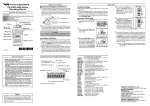
1
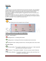
ALL IN APP USER MANUAL Sint Ignatiusstraat 134 9120 Kallo (Beveren-Waas) Belgium +32 474 727 135 [email protected] www.sonarcom.be Product Specifications: 4 in 1 device with; GPS, Sonar, Autopilot and 3D output for making bathimetric charts Supported by 5 languages; Dutch, English, French, German and Polish. Text and voice language will addapt in function of the Android device settings. Authorised use in Europe Works on android 4.4 or higher devices with bluetooth, best on 800x1200 pixels GPS specifications 500 memory locations for waypoint storage Home return function for autopilot Make a route up to 40 points, special for recording 3D maps Boat battery monitoring with voice alarm Steering with flagged marker and left/right indicators Auto zoom Radio link distance up to 1000 meters on ISM band 869 (sub band 6) license free to use in whole Europe using FHSS Long Range duplex! Transmitter output power 50 mw Rx is binded to TX with unique ident Fast update of position (6x sec.) Maximum plot range 999 meters Ublox Neo6 next generation GPS receiver maximum 60 satellites tracking Accuracy Position 5 meters 2D-RMS 1 meters 2D RMS WAAS Current consumption transmitter (boat site) 0,2 amp Current consumption Bluetooth module 0,03amp Autopilot suitable for boat systems 1 motor /1 rudder, 2 motors /2 rudders, 2 motors /no rudders , 2 nozzle/jet boat Max range of autopilot 999 meters Accuracy of arriving to selected spot within 1 meter Failsafe build in: max range + blocking by obstructions + rf link failures Easy setup of AP, using simplified menus Automatic feeding at selected spot possible Calculates track with 10 GPS updates/seconds Adjustable colors for background, text and vectorline SONAR specifications Depth range 0.25-30 meters, resolution 2 cm Dynamic AGC function to suppress phantom echoes in range 0-5 meters Digital Encryption of the transmitted signals. Dual scan transmission 200 kHz and 455 KHz Temperature transmission Echo amplitude transmission Update sounding measurement ca 6x/seconds Adjustable settings: - Bottomfill on/off - Autorange on/off - Ping speed (5 settings) - Full color settings possible ( bottom, background, highlevel, medium level, low level, text ) SONARCOM ALL IN APP Pagina 1 Operating the APP: GPS Mode selection: Each mode (GPS / SONAR / GOOGLE MAPS) can be accessed by short click on the mode bar on the bottom of the screen. Long click on each mode will give the adjustment menu for that specific mode. The plotting screen: Indicated on the screen from upper left till bottom right…. RF field indication, showing the received signal strength Information about the actual number of satellites insight The actual boat speed in km/hours The distance to the spot in meters The actual voltage of your baitboat battery (alarm settings possible) The battery voltage of the Bluetooth receiver on the shore (alarm setting possible) The actual latitude/longitude GPS position/coordinates of the baitboat The scale of the display All these indicators will be displayed in the Google Maps mode SONARCOM ALL IN APP Pagina 2 Battery status of your boat and Bluetooth receiver: The boat voltage and the Bluetooth receiver voltage will be transmitted to the app. In case the voltage of the boat becomes lower then te specified treshold, a voice alarm will be given and repeated every 30 seconds. No voice alarm will be given for the Bluetooth voltage. The BT (Bluetooth) receiver is equipped with a rechargable 2600mA Li-ion battery pack. This gives a battery life of approximately 45 hours. The battery pack is protected against: over charging, over discharging, over current protection and short circuit protection. The BT receiver battery pack can be charged with the included charger, use it properly. If you want to use a different charger than respect the polarity (mantle - and core +) and charging current (8.4V). Spot Icons: Spot Nearby spots Stored spots Save spot Spot icon is displayed on your GPS vector screen. It represents your previously saved and loaded waypoint. Nearby spots icon draws up a shortlist of all your saved wayoints within a range of 900 meters. It will take the boat position as a reference. To load a spot, scroll trough the list and select the spot by clicking on it. You will get a confirmation message that the spot has been loaded, and the spots name will appear on top of the app next to the APP-version number. Stored spots icon will give al list of all stored spots on your device. Scrolling through this list is easy by moving the list up/down. Each spot can be modified, or deleted. To change the spot name: long press on the spotsname, you will get an input menu to insert the new name. To delete a spot: you click on “erase” instead of inputting a new name. To change latitude/lon positions: long press on lat or longitude field, and input the new position. !!!!! you can not load a spot from this list, therefore use the nearby icon!!!!! Note: latitude and longitude must have a minus sign (-) when the latitude is west of London and longitude south of the meridian line. Example: W41.0011 should be inserted as -41.001. East 004.002 should be without any sign. South 61 degree should be inserted as -61 degrees, North 51 degrees should be inserted without any sign. Save spot icon will save the actual boat position, you will get a confirmation screen. To be sure the spot is saved properly do not move your boat before you passed the confirmation screen. SONARCOM ALL IN APP Pagina 3 Home icon: The moment you connect to the Bluetooth receiver/boat tranmitter, the actual GPS location will be stored in the memory in case there are more than 4 satellites! The Home icon will appear to indicate the boats home position has been stored. If you want to redefine the home position, long press on this icon to save the new actual boat position. A short click on this icon will give a selection of loading the home position into the Autopilot, or loading it into the autopilot and to start right away the autopilot (without any R/C command). This is called “force start home”. Autopilot Icon: By clicking the icon the autopilot menu will open. You can see next icons from upper left to right bellow. Feeder 1 and feeder 2: feeding state off: no feeding will be done. feeding state on: feeding will be done automaticly when boat arrives feeding state done: feeding has been done, click the green arrow icon to reset Autopilot states: AP state standby: The autopilot is standby but not active yet. Load a spot and give full throttle for at least 5 seconds. AP state off: The autopilot is disabled. You have manual control of the boat. AP state calibration: No autopilot is possible, First the radio control has to be calibrated to the boatmodule. SONARCOM ALL IN APP Pagina 4 Route states: Gotospot state: The boat will go to the loaded spot, feed if selected, and stop. Autoreturn state: The boat will go to the loaded spot, feed if selected, and returns to the home position. note: be sure your fishing line is fast sinking when you use this option! Route state: The boat will go to the selected spots of the routelist, and stop at the last selected spot. Feeding option has to be inserted before the boat reaches the spot. (see this manual ‘make route’) Boat speed: The Boatspeedmenu is used to specify the cruise speed of the baitboat. To change the speed click on the icon and a menu will be open to input a new speed by dragging the pointer of the gauge. Note: the speed regulation is depending on the settings in the AP factorysettings menu, you can only adjust between minimum and maximum settings as defined in the factory settings. Autopilot manual: The GPS has a build in autopilot, capable to steer the boat within 1 meter range of the selected spot. To operate the autopilot follow the indicated steps. 1. First select and load a spot, this spot. 2. Be sure you got at least 6 satellites, best performance will be with 10 sats or more 3. Open the autopilot menu by clicking on the autopilot icon. 4. Arm the autopilot by clicking on the AP-icon, you will see the ap-standby symbol. 5. Close this menu by clicking on it, or return key of android. 6. Steer the boat manually full throttle in the direction of the spot for at least 5 seconds. The autopilot will be switched on, a bell sound will be given and in the top of the app the sign AP will be painted. Release the throttle stick to neutral as soon you hear the “gps active” voice will be given. Note: Be sure that you have the Bluetooth module with the antenna upwards and at least 1 meter above the ground. The range will be significantly decreased when the Bluetooth module is lying on the ground. The Bluetooth module has to keep contact with the boat during the trip, otherwise the failsafe will become active and the boat will return to the home position! Note: The autopilot has to settle during the first seconds and thus making large turns. Never steer the boat towards shore site, always towards a free area. Remember the autopilot will make a straight line to the spot, any obstruction between start point and waypoint will block the boat. Note: all actions, feeder On, AP Standby, AP off, One-way, Return Home, and Execute route will have voice confirmation. 7. To disable the autopilot, give FULL reverse throttle for at least 1 second. The AP arming will also be disabled. If you want to enable the AP again, repeat steps from step 3. SONARCOM ALL IN APP Pagina 5 Failsave Autopilot: To insure that in case of some error the boat will stop of return to base some features has been added into the autopilot. The maximum range the autopilot can operate is 999 meters from the start point. In autopilot mode the boat will stop when the distance is more than 999 meters from start point. In case the duplex link between the GPS display and TX module has been interrupted for more than 30 seconds, the boat will return to the start point so called failsafe. The failsafe doesn’t work if the boat is in the range of 20 meters of the start point. The start point is activated/stored the moment that the autopilot was armed and has given 5 seconds full throttle. This will say that the failsafe will never become active if the boat wasn’t operated in the autopilot mode! In other words: the failsafe won’t become active in manual mode (no AP used). If the boat is blocked by some obstructions, the motor(s) will cut off after 15 seconds. Therefore the slowest cruise speed cannot be lower than 1.5 km/h this to avoid this failsafe to become active. This is not active in the manual mode! GPS settings menu: A long click on the GPS mode button, in the bottom bar of the screen, will open the GPS settings menu. The vectormode button allows you to display or hide the vector line. Adjustments of Panel, Text and Vector Color can be done by clicking on it. In all cases you can reset these colors back to default in factory settings menu. You can specify on what level the voice alarm will be given when battery is low. Sound on/off Automatic or manual Bluetooth connection. Left Handed/Right Handed. The Gps/Sonar icon bars can be switched. SONARCOM ALL IN APP Pagina 6 Operating the APP: SONAR Depending on your choice of package will have a 200 and/or 455 kHz sonar. The sonar screen has 3 modes: 200kHz full screen, 455kHz full screen and the dualscan screen with 200 and 455 kHz side by side. Switch between 200kHz full screen / 455kHz full screen / 200+455kHz screen. dualscan Click to adjust the depth rande up or down. Click to zoom in/out on the plot. SONAR settings menu: A long click on the SONAR mode button, in the bottom bar of the screen, will open the SONAR settings menu with following items: Bottom Fill: On/off will give a track over ground, the bottomline (Only on 200khz plot) will be filled up. Auto range: On/off of automatic adjustment of the depth range. Pingspeed: settings of very slow, slow, normal, fast and very fast of the ping (movement of the sonar plot) SONARCOM ALL IN APP Pagina 7 Start Bathymetric record (making of 3D-charts). When the records is started, the file will be located in the ‘APP’ directory on your Android device. This .csv file can be imported to Reefmaster software. Play/Stop/Record. When you like to record a trip and playback later on. (Not making a 3d chart). Only 1 option can selected: Bathymetric record or just making a sonar record. The sonarrecord is for no other use, only to play back on the app. Daylight/Night theme, personal colors. Presetted are daylight and night theme colors, no changes can be these modes. In Personal settings extra adjustments will be added to adjust all colors of the sonar plot. Bottom color change of the track over ground color 200khz Canvas Color 200 khz/455khz. The background color of the sonar plot Text color all indications can be adjusted in color High/medium/low level colors 200 kHz and 455 kHz: each echo has 3 levels: max, medium and low. With adjusting those colors you will get a more detailed picture of the surface. SONARCOM ALL IN APP Pagina 8 Operating the APP: GOOGLEMAPS With Google maps you have a great tool to observe the boat position, and to add new spots directly from screen. This is a big advantage when you are making a bathimetric record for 3D-mapping. Add a new spot: Long press on the screen location, till you got the confirmation message. Note: SaveSpotGoogleMaps should be ON in the googlemaps settings Load a spot: click on an already saved spot and it will be loaded after confirmation Make a route list: click on a spot and select ‘route’ (‘parcours’). A route list will be build from the boat position. The boat will go from spot to spot, specially for building 3D maps. Note 1: you can also add a spot without saving it first. No marker will be placed, but the route position will be inserted. Note 2: The constructed route will be lost when the app is closed. It isn’t saved on disk! Googlemaps settings menu: A long click on the Googlemaps mode button, in the bottom bar of the screen, will open the googlemaps settings menu with following items: Save googleSpots: To avoid adding spots, you can disable this feature Google Maps Terrain, Satellite, Normal: 3 modes of Google maps can be selected Google maps Head up/Northup: In Northup mode the picture is always heading north. In Head up Mode the picture is heading the selected spot, so the image is the same as you will see from shore site. Route: When clicking on this you will see the build route list. A selected spot of the route list can be deleted by clicking on it. A conformation screen will be given. SONARCOM ALL IN APP Pagina 9 Operating the APP: APP SETTINGS To access the Appsettings, search for the icon with 3 dots, most likely upper left in the android device. The menu will open and you will get these settings: Connect Bluetooth. Select BT Bait boat and click. Wait around 20 seconds. A message will be given as soon the Bluetooth connection is established Searching Devices. In case of first time of use the bluetoothdevice has be searched. Select this option and wait around 1 minute. As soon something is found, check it is the bait boat Bluetooth device. Note: Sometimes you will see no name the first time. Select this device and a password has to be given: 1234 Disconnect: to disconnect the Bluetooth link. Note: In case the app will be closed, the BT will also be closed Factory settings: See Factory Settings Exit. To close the app (the android return key has the same function) Operating the APP: FACTORY SETTINGS You can open the factory settings menu in the app settings menu. The menu will open and you will get these settings: Check Update. If needed the app will be updated. This is not every day, it’s useless to try to update every day the app. If a update is there, click this line, and when the message “Checking Update” comes, wait until the installation message will show up. Click on “Install”, the App will close. Wait another 10 seconds, and restart the APP. The new update is there! Reset Default Colors. You can reset all color adjustments back to default SONARCOM ALL IN APP Pagina 10 Reset Menu positions. You can reset all menu positions, in case something happened, to the original settings when you received the device. Your records or spots won’t be erased. Credit/Google License : for information only Factory Settings. With a special pin code setup adjustments for sonar and autopilot can be done by your distributor. Installation of the APP If you got a new android device make sure that you first update Google maps before you install the APP. If you got this error message java.lang.NullPointerException Google maps is not updated! Go to Android settings, menu ‘security’ and enable the option “accept apps from unknown devices” The app will create a few directories: -Sonar where you will find records made of the sonar records -Bathymetric, where you will find records made for 3d applications -Documentation After you have successfull installed the app, you can open it. The next step is to pair your BT device: Open the APP settings menu by clicking on the 3 dots in the upper right corner of your tablet. Select ‘searching devices’ and wait aprox 30 seconds when the app will show you the found BT module. Select ‘BaitBoatGPS’ to connect. Note: Sometimes the first time you won’t read “BaitBoatGPS” but a blank row. Just select this device and insert pin code 1234 After pairing you can let the APP automatic connect to the BT module, only make sure the BT module is powered by a battery before the APP is started, otherwise you will get error messages. Note: keep the BT module close to the android device: the max distance is 5 meters, but this is depending on the sensitivity of the android device. When the BT link is there a short message will be given and in the upper taskbar the app-icon is visible. SONARCOM ALL IN APP Pagina 11