1
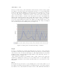
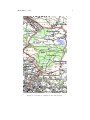
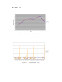
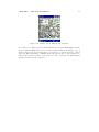
Semester Thesis
GPS on iPAQ
Philip Frey
[email protected]
Dept. of Computer Science
Swiss Federal Institute of Technology (ETH) Zurich
Prof. Dr. Roger Wattenhofer
Distributed Computing Group
Supervisor: Aaron Zollinger
Winter 2004/05
Contents
1 Introduction
2
2 GPS
2.1 HAiCOM GPS Receiver . . . . . . . . . . . . . . . . .
2.1.1 NMEA 0183 . . . . . . . . . . . . . . . . . . . .
2.2 Accuracy and Reliability of the GPS Receiver . . . . .
2.2.1 Accuracy: Position, Height and Speed . . . . .
2.2.2 Reliability: Evaluation in Everyday Situations
.
.
.
.
.
.
.
.
.
.
.
.
.
.
.
.
.
.
.
.
.
.
.
.
.
.
.
.
.
.
.
.
.
.
.
.
.
.
.
.
.
.
.
.
.
3
4
4
4
4
6
3 The Java Programs
3.1 GPS API . . . . . . . . . . . .
3.1.1 GPS Tools . . . . . . .
3.2 Java Applications . . . . . . . .
3.2.1 GPS Tracer . . . . . . .
3.2.2 GPS Painter . . . . . .
3.2.3 GPS Visualizer . . . . .
3.2.4 GPS Map . . . . . . . .
3.3 Work Progress and Difficulties
.
.
.
.
.
.
.
.
.
.
.
.
.
.
.
.
.
.
.
.
.
.
.
.
.
.
.
.
.
.
.
.
.
.
.
.
.
.
.
.
.
.
.
.
.
.
.
.
.
.
.
.
.
.
.
.
.
.
.
.
.
.
.
.
.
.
.
.
.
.
.
.
10
10
11
11
11
14
14
16
16
4 Conclusion
4.1 Jeode . . . . . . . . . . . . . . . . . . . . . . . . . . . . . . . . . . . .
4.2 Thinlet . . . . . . . . . . . . . . . . . . . . . . . . . . . . . . . . . . .
4.3 GPS . . . . . . . . . . . . . . . . . . . . . . . . . . . . . . . . . . . . .
18
18
18
18
5 Useful Hints
19
A Contents of the CD-ROM
25
.
.
.
.
.
.
.
.
1
.
.
.
.
.
.
.
.
.
.
.
.
.
.
.
.
.
.
.
.
.
.
.
.
.
.
.
.
.
.
.
.
.
.
.
.
.
.
.
.
.
.
.
.
.
.
.
.
.
.
.
.
.
.
.
.
.
.
.
.
.
.
.
.
.
.
.
.
.
.
.
.
.
.
.
.
.
.
.
.
.
.
.
.
.
.
.
.
.
.
.
.
.
.
.
.
Chapter 1
Introduction
One of the most commonly used positioning systems today is the Global Positioning
System (GPS). The goal of this semester thesis is to acquire information from this
system and save as well as display them in an appropriate manner on an iPAQ device. In particular I used a Compaq iPAQ 3870 PDA (portable digital assistant) in
combination with a HAiCOM GPS receiver [6].
I started parsing the data from the GPS receiver. After that my task was to develop
some applications that operate on the GPS API written in the first step and in the
end to determine how accurate and reliable this system is. The applications should
display as well as trace the position information in an appropriate way.
All of the software is written in Java since it is then possible to run the same program not only on the iPAQ but on any system with a serial port (e.g. PCMCIA or
CompactFlash interface for the HAiCOM GPS receiver to fit in) and a Java Virtual
Machine (JVM) version 1.1 or higher. The two disadvantages of this approach were
the slightly limited JVM available for PDAs and the loss in speed that comes with
its additional abstraction layer.
2
Chapter 2
GPS
The system was originally developed by the U.S. Department of Defense [2] for military purposes only. Until May 2000 timing errors were inserted to limit the accuracy
to 100-200m. Without this so-called selective availability it is now possible to determine your position within a range of less than 10m if enough satellites are available.
There are at least 24 operating satellites that orbit the earth in 12 hours. Their
constellation is such that from any point on earth you should be able to get signals
from usually five to eight satellites at a time. A line of sight between the receiver and
the satellite is required in order to use it.
Figure 2.1: GPS Constellation
For more information about GPS see [3] and [4].
3
CHAPTER 2. GPS
2.1
4
HAiCOM GPS Receiver
For this thesis I used a GPS receiver by HAiCOM [6]. It is mainly a CompactFlash
extension card that comes with an adapter for the PCMCIA interface and therefore is
treated as a serial interface in Java. The iPAQ had to be equipped with a PCMCIA
jacket for this purpose. The receiver comes without much software. All I had was
a small application to test whether the device was working and to determine the
correct COM port for it. The GPS information is given in the NMEA v2.2 format
(also known as NMEA0183). The receiver produces an updated version of each part
of the NMEA0183 protocol every second. For detailed specifications see [7].
2.1.1
NMEA 0183
NMEA stands for National Marine Electronics Association [5] and consists of a standardized set of giving info ’sentences’ from which I used the following:
GGA (Global Positioning System Fix Data)
GSA (GPS Dilution of Precision and Active Satellites)
GSV (GPS Satellites in View)
RMC (Recommended Minimum Specific GPS Data)
The most important fields of the GGA sentence are the UTC (Coordinated Universal
Time), latitude, longitude, altitude and the current dilution of precision.
The GSA sentence gives information about the satellites that are currently used for
the determination of the position. All visible satellites then are listed in the GSV
sentence and the RMC gives a kind of summary including UTC and date, latitude,
longitude, speed and course. This is the most interesting information for ”everyday
life”.
2.2
Accuracy and Reliability of the GPS Receiver
2.2.1
Accuracy: Position, Height and Speed
According to the manufacturer of the GPS receiver (HAiCOM) we should be able to
determine where we are within a radius of 10m in 95% of the cases. For the velocity
they specify an accuracy of 0.1 meters per second (0.36km/h). The time should be
within 1 microsecond synchronized to the GPS time. In addition to this I did my
own tests. I drove and walked around taking samples in constant intervals. The GPS
receiver indicates the accuracy in terms of Horizontal Dilution of Precision (HDOP),
Position Dilution of Precision (PDOP), Vertical Dilution of Precision (VDOP). DOP
is a mathematical representation for the quality of the GPS position solution. The
lower these values are the better is the accuracy (the optimum is 1). The following
three sections present results.
Position
The accuracy highly depends on how many satellites are visible and how they are
distributed. The wider the satellite distribution and the more satellites are visible
CHAPTER 2. GPS
5
the more accurate is the position information. The absolute position accuracy equals
the dilution of precision times the measurement precision. So, if the measurement
precision is 1m and the PDOP is 5, then the best position accuracy we can hope
for is 5m. The maps in Switzerland are subdivided by a grid with cells of 1 km2
each. I used that grid to estimate the accuracy of the device in the following way:
First I located a number of points on the map then I drove there and sampled the
latitude and longitude values at these points. The next step was to determine the
mean values of the samples and transform them into Swiss coordinates according to
[8]. Now I could calculate the deviation (see Figure 2.2). These figures are not very
precise though in fact it is not much more accurate than 5m. An overlay of a sampled
route and the map shows a similar picture (see Figure 2.3).
Figure 2.2: GPS position deviation from map coordinates
Height
In order to determine how accurate the height data is, I decided to visit points that
are marked on the map with exact heights. I used the Landeskarte der Schweiz Blatt
1112 Ausgabe 1998, 1:25000 for that purpose. The height indicated by the GPS
module does not correspond with the height marked on the swiss map. It has to be
transformed first according to [8].
The deviation in Figure 2.4 is within a range of 11m. Even if more than four
satellites are available the accuracy does not get much better. So the height is the
least accurate information. In tendency the GPS values are a few meters above the
map values.
Speed
To measure the speed I went to a long straight part of a motorway. There I took
the distance information that is marked every 200m along the road and determined
the distance I drove and measured the time needed for that. With that information
CHAPTER 2. GPS
6
I could calculate the approximate speed. Then I compared this speed to the speed
of the car I was using, taking into account the error of the car’s speed indicator
which I got from a car magazine. The combination of these two methods allowed me
to determine my actual speed at an accuracy of about 1km/h. It was not possible
though to verify the specified 0.36km/h accuracy but I could verify that it is within
1km/h. Presumably this is enough for all practical purposes.
2.2.2
Reliability: Evaluation in Everyday Situations
To determine the reliability of the device, I chose two typical situations for the employment of the GPS system. The first one of them was a road trip that started at the
harbor, led me through some smaller villages and over interurban roads. The second
one was a walk through a canyon in the forest. As a measure I used the number of
available satellites as well as the DOP (see figures 2.5-2.7). The minimum required
number of satellites to determine the current position is three (four for the additional
height information). A direct line of sight to the satellite is required.
Road
On the road I almost never had less than three satellites and the average number was
around 6. It attracts attention that there are some peak values in the DOP-curve.
They correspond always to the loss of at least one satellite. The opposite direction is
not necessarily true though. The figures in the city (Zurich) were similar. I therefore
do not present them here.
Forest
The walk through the forest shows a similar picture (Figure 2.4). I started the sampling outside the forest, walked about 15min through a small canyon covered with
trees and ended up on a hill above it. The average number of satellites used was
around 4—still enough to calculate the current position. On my way back down I ran
(Figure 2.7). In this third chart it is remarkable that the average DOP value is much
higher than in the other ones. It consists almost only of peaks although the average number of satellites was not much lower (around 3.5). The reason for the peaks
is that we are close to the critical amount of the necessary three or four satellites,
respectively.
CHAPTER 2. GPS
Figure 2.3: Overlay of a sampled route and the map
7
CHAPTER 2. GPS
8
Figure 2.4: Height correlation between map and GPS
Figure 2.5: Road trip through villages
CHAPTER 2. GPS
9
Figure 2.6: Walking through the forest
Figure 2.7: Running back through the forest
Chapter 3
The Java Programs
3.1
GPS API
The API that parses the NMEA0183 sentences mentioned in 2.1.1 was the core part
of my thesis. First of all I had to get the data through the serial port of the iPAQ
from the GPS receiver into my Java program. The corresponding API (Java Communications API) was defined but not implemented for the PocketPC. So I used
an implementation written by James Nord [10] in order to communicate with the
GPS receiver. The next step was to parse the NMEA0183 sentences. Each sentence
begins with a ’$’ followed by some numbers separated by commas and ends with
’<CR><LF>’. For the exact meanings of the numbers in the different sentences see
the User Manual (Chapter ’Output Protocol’) at [7].
I decided to use for each sentence an individual class in Java to store the current GPS
information. Here is an example of how to use the GPS API:
1:
2:
3:
4:
5:
GPS gps = new GPS( "COM5:" );
RMC rmc = new RMC();
try {
gps.updateRMC( rmc );
} catch ( Exception e ) {}
Line 1 initializes the GPS API on COM5, Line 2 creates a new RMC object and
Line 4 updates the RMC Object with the current GPS values. It is not possible to
open the GPS API more than once otherwise an Exception will be thrown. All the
information included in an RMC sentence can be accessed as member variables of the
rmc object. In order to get the current latitude: rmc.lat; would for instance be used.
All the Java classes contain exactly the same information as the corresponding NMEA0183
sentences. The only exception is the RMC class, where I have added a function
getSpeedKMH() to get the current speed in terms of km/h instead of knots.
It is also possible to get the unparsed InputStream handle for the byte stream of the
GPS receiver from the GPS API. For that purpose I have provided the following two
functions:
public InputStream startGPS()
public void stopGPS()
10
CHAPTER 3. THE JAVA PROGRAMS
11
In addition to this it is possible to flush a certain amount of characters onto the
standard output with the function flushData(int). The Javadoc to this API is
available at [1].
3.1.1
GPS Tools
Some tools that might be useful but do not directly belong to the GPS API can
be found in the class GPS Tools. It includes public Sats[] getAllSatsFromGSV()
which provides complete information about the visible satellites in a structured way,
public String nmeaLines(int) which returns the specified number of NMEA0183
sentences as a string and finally a method to find out which ports are available in the
system called public String listAvailablePorts().
3.2
Java Applications
A further task of my thesis was to design and implement a sample application that is
based on the API written in the first part. Instead of one large applications I wrote a
few smaller ones that use various kinds of information provided by the GPS system.
I decided to do the GUI with Thinlet [11], as it is relatively easy to learn and based
on pure AWT, which is fast enough for the PocketPC. One of the main advantages
of Thinlet is that you can describe your GUI in XML and without having knowledge
about AWT, although it might be possible that there is a more efficient way to
implement the GUI part directly with AWT. It would be possible to use Swing as
well but referring to [9] it seems to be too slow and you need some tricks to get it
running.
I implemented three programs designed for the iPAQ and one to visualize the stored
GPS information on a desktop computer (see sections below). All of them operate
based on the model-view-controller pattern and are fully multi-threaded. There is
always a class containing the main() function which is responsible for showing the
GUI and starting/stopping the threads. Their job is to keep updating the GUI with
current information.
3.2.1
GPS Tracer
This application allows the user to see the GPS information in a human readable
version. It consists of a few tabs containing various kinds of information about the
current position (Figure 3.1), the satellites that are currently used (Figure 3.2), the
dilution of precision, the tracking mode etc. Furthermore it is possible to watch the
NMEA0183 sentences (unaltered) as soon as they are received (Figure 3.3). A last
part provides the possibility to do a tracing over a time period. That allows the user
to store all the gathered position samples into an XML file. The user can choose what
should be stored (limited to the information contained in the GGA sentence) and in
what interval the samples should be taken (Figure 3.4). This interval is limited to 2
seconds because it takes about 1 second to parse the appropriate sentence and the
sentence is only received once a second). While tracing it is possible to watch the
change of the altitude in an online chart (Figure 3.5).
CHAPTER 3. THE JAVA PROGRAMS
Figure 3.1: Current position information.
Figure 3.2: Currently used satellites.
Figure 3.3: NMEA sentences.
12
CHAPTER 3. THE JAVA PROGRAMS
Figure 3.4: Recording GPS information.
Figure 3.5: Altitude graph.
13
CHAPTER 3. THE JAVA PROGRAMS
14
Figure 3.6: Painted route.
3.2.2
GPS Painter
The GPS painter was originally called ”Human Pen”. The idea is that the user
becomes a pen on the world and the application paints his movements in real-time
onto the iPAQ display (Figure 3.6).
Once the user has finished his/her journey it can be saved into an XML file similar to
the one from the GPS Tracer (Figure 3.7). There are only minor differences between
the two XML files.
To view the trace sometime later this XML file can be imported again; the program
can be run in Simulator mode so it will not use the real GPS data but the ones from
the XML file specified (Figure 3.8).
It is possible to set some options that will improve the way the current trace is
displayed (Figure 3.8). These options include a zoom factor, the origin on the screen,
the sampling interval and some visual options (draw sample points and connections
between them). The zoom factor goes from 1% to 100% where the first reveals more
details and the latter gives an overview of the journey. When 1% is used, one pixel
corresponds approximately to one meter where with 100%, one pixel corresponds to
one kilometer. These are just estimates to give an idea about the dimension. A
summary of the current settings is available in the ’Info’ menu.
The most difficult part of this application was to be able to paint directly on the
GUI through its graphics context. I had to use a patched version of Thinlet because
the original one did not support painting at that time. The patched version offers
the possibility to define a paint() method that is called whenever it is needed. The
method repaint() allows a manual invocation of the paint() function (see Chapter
5 for details).
3.2.3
GPS Visualizer
In order to display the gathered data (from the GPS Tracer as well as from the GPS
Painter ) on a desktop computer with larger capacity I wrote the GPS Visualizer.
This tool has some additional features but is still based on the GPS Painter. For
example specific colors for the background or the trace etc can be set or an image
can be exported as a JPG or PNG file. This operation takes too long on the GPS
CHAPTER 3. THE JAVA PROGRAMS
Figure 3.7: Save journey in XML.
Figure 3.8: Available settings; activated simulator.
15
CHAPTER 3. THE JAVA PROGRAMS
16
Figure 3.9: GPS Map.
iPAQ since Java 1.1 does not support these image export functions directly. I tried
to solve this problem with a tool by Sun called Jimi [14] but the PocketPC was not
fast enough. It took about one minute to produce the output of a trace with only a
few dozen samples and the size of the image was restricted to about 800x800 pixels;
I consequently decided to implement this functionality on the PC only.
3.2.4
GPS Map
What would GPS be without a map? So I implemented another variant of the GPS
Painter this time with segments of the Swiss map in the background (Figure 3.9).
The little red crosses indicate the visited positions. The map has been divided into
segments of 1km2 each. If you leave one part of the map, the application switches
to the next one and so forth. The trace will be saved so that if you return into a
previous part your old position samples will be still there. It is also possible so switch
between different map segments manually (Figure 3.10). In this tool the user is offered
the possibility to save his journey into an XML file in the same way as in the GPS
Painter. The accuracy is on average between five and ten meters. In the program
there are currently 56km2 of the city of Zurich available but it is very easy to add
more segments as long as they follow the predescribed rules. In order to work with
the hard coded program settings the map segments must be parts of 1km2 x1km2 each
and scaled to 234x234 pixels. The upper left corner of the square kilometer rectangle
has to be 10 pixels off the top and left border.The square kilometer rectangle itself
must be 200x200pixels. The code could also be easily adapted to meet different map
specifications.
3.3
Work Progress and Difficulties
The first difficult thing was to find out how the Jeode JVM can communicate with
the GPS receiver. I browsed the web and found the solution at http://www.teilo.net
(see Chapter 5 for details). The parsing of the NMEA frames was not too tricky
anymore after having read the exact specifications of the standard although it took
me a while. Then I had to look for a possibility to design the GUI since I have never
CHAPTER 3. THE JAVA PROGRAMS
17
Figure 3.10: Switch between different map segments.
done that before. There are some valid alternatives to the pure AWT/SWT or Swing.
I can recommend Thinlet since it is very well documented with some samples—a good
start for anyone who needs a GUI and does not want to or cannot follow the common
approach. The disadvantage of Thinlet showed up when it came to the real-time plot.
I had to use a patched version of it in order to be able to draw into the GUI using its
graphics context (see also Chapter 5).
Chapter 4
Conclusion
4.1
Jeode
One of the most popular advantages about Java is its platform independency. This
thesis gave me a good opportunity to test it. Once I had written an application for
Jeode (the Java Virtual Machine running on the iPAQ), there was no problem running
the same application on the notebook as well. The other way round is not necessarly
true though. On the laptop I wrote the applications for Java 1.4.2 whereas Jeode is
based on the older Java 1.1 with a reduced function set. There are a lot of things
not available on Java 1.1 when it comes to graphics. This increased the work a lot by
things that should be available by default these days.
4.2
Thinlet
Thinlet offers a simple way to create nice looking AWT GUIs with almost every
functionaliConclusionty. The idea of Thinlet is that the user specifies the look of the
GUI in an XML file. This will then be parsed at runtime and the corresponding AWT
GUI will be created.
I didn’t miss anything except the possibility to paint directly in the GUIs graphics
context. Fortunately this feature can be added by using the patched version of Thinlet
(see Page 21). It should be available in the next standard version as well. Nevertheless
I would rather use AWT directly for a next thesis. So you do not depend on a feature
to be implemented but you are able to use the whole AWT API as such. It would be
really bad if there was an important feature missing which was fortunately not the
case during my work.
4.3
GPS
The GPS system needs a direct line of sight to the satellites in order to work. This
results in some overhead during the testing phase. The programs have to be tested
outdoors. It takes about one or two minutes every time the GPS has to reinitialize
before it produces the first valid set of data. In order to circumvent this outside
testing overhead, I wrote the simulator which is available in the GPS Painter.
18
Chapter 5
Useful Hints
As it was pretty tough to start in such an unfamiliar environment I would like to give
some hints here how to do the most basic things with Java and the iPAQ PocketPC.
Some very helpful tips and tricks concerning the installation of the JVM on the iPAQ,
the basics of Jeode and debugging can be found in [9].
Where to find some more information about Jeode.
Some very useful information about Jeode can be found in the semester thesis by
Nicolas Burri [9] and on the following website:
http://www.cs.unc.edu/ lindsey/7ds/notes/jeode
How to set up Eclipse with the correct compiler for Jeode.
Throughout the project I I worked with Java 1.1.8 as recommended in [9] and had
no problems at all running the programs on the iPAQ. So download JDK 1.1.8 and
unpack it somewhere into your system (e.g. C:\jdk1.1.8). For the next step start
Eclipse and set the JRE as well as the corresponding compiler. Go to
Window->Preferences->Java->Installed JREs
and add the jdk1.1.8 (or whatever you are using) then go to Compiler, choose the tab
Compliance and Classfiles and set the Generated .class files compatibility
to 1.1.
How to access a device through the serial port of the iPAQ.
First of all you need to install the Java Communications API on the iPAQ as follows:
1. Download the archive from http://www.teilo.net.
2. Copy CESerial.jar, comm.jar and javax.comm.properties into a new folder
19
CHAPTER 5. USEFUL HINTS
20
on the iPAQ (e.g. \windows\Java) and commapi.dll into \windows.
This driver for the serial port is free for non-commercial use.
Now you can access the serial port as described in [10]. There is some sample code
which shows the recommended way of doing it.
Your link to start the java application on the iPAQ using the serial interface has to
contain the Java Communications API in the classpath:
80#"\Windows\evm.exe" -cp \windows\Java\comm.jar;\windows\Java\CESerial.jar
MyClass
Where to get the exact specifications for the NMEA0183 sentences from
the HAiCOM GPS receiver.
http://www.haicom.com.tw/support.htm
How to test the GPS receiver.
I used the little tool called ”GPS Info” available at the HAiCOM website mentioned
above.
The serial port settings for the GPS receiver.
Baudrate: 4800, Data bit: 8, Parity: None, Stop bit: 1, Flow control: None
How to create Javadoc from source files.
In your code you have to use the following syntax to create Javadoc contents in your
source code:
/**
* my Javadoc comment
*/
At the end you can export these comments as Javadoc by choosing
File->Export...->Javadoc
and specifying the source files you want to include.
For more details see [15].
CHAPTER 5. USEFUL HINTS
21
How to create a Thinlet GUI.
The idea behind Thinlet [11] is to specify the look and feel of an AWT GUI in an
external file that is parsed whenever the program is executed. There are lots of easyto-use components (called widgets) you can use to build up your GUI. In your Java
code (the controller) you have to import that XML description and initialize a new
Thinlet object (see example below). For details please refer to [11]. A very small
example can be found at [12].
Java example:
1:
2:
4:
5:
6:
7:
8:
9:
10:
import thinlet.*;
public class MyClass extends Thinlet {
public MyClass() throws Exception {
add(parse("description.xml"));
}
public static void main(String[] args) throws Exception {
new FrameLauncher("MyClass", new MyClass(), 320, 240);
}
}
I cannot find the file I have just created with my Java application?!
If you do not specify the whole path, the files are always stored in the root directory
of the iPAQ.
How to create image files with Java 1.1.
Since this feature is not yet supported you have to use something like Jimi [14]. It is
very limited and slow due to the restricted resources of the iPAQ.
How to paint into the graphics context of the Thinlet GUI.
This feature is not contained in the stable release yet. So you have to patch the
thinlet.jar file.
1. Unpack the thinlet jar archive (jar -xf thinlet.jar).
2. Replace the file Thinlet.java with the one from [13] (rename it to Thinlet.java)
and build the jar file again (jar -cf thinlet.jar *).1
Now you have an additional attribute for every component called paint="myPaintMethod"
where you can specify a method that is called whenever a repaint of that specific component is needed. It needs to have the following signature: public void
1 You
can omit the MANIFEST-INF.
CHAPTER 5. USEFUL HINTS
22
myPaintMethod(Thinlet t, Object component, Graphics g, int width, int height).
Therein you can redraw the component (e.g. with g.drawLine(fromX, fromY, toX,
toY)).
How to take screenshots on the iPAQ.
There is a small freeware tool called PocketSnap available at [16]. On older devices
it might be necessary to install the .NET Compact Framework first. It is free as well
and available for download at [17].
Bibliography
[1] ”GPS on iPAQ” Website
http://bosco.ath.cx/gps
[2] U.S. Department of Defense Official Website
http://www.defenselink.mil
[3] GPS: A New Constellation - Exhibition Home Page
http://www.nasm.si.edu/exhibitions/gps
[4] Global Positioning System Overview
http://www.colorado.edu/geography/gcraft/notes/gps/gps f.html
[5] The National Marine Electronics Association
http://www.nmea.org
[6] HAiCOM GPS
http://www.haicom.com.tw
[7] HAiCOM GPS - Support
http://www.haicom.com.tw/support.htm
[8] Formeln und Konstanten fuer die Berechnung der Schweizerischen schiefachsigen
Zylinderprojektion und der Transformation zwischen Koordinatensystemen
http://www.swisstopo.ch/data/geo/refsysd.pdf (Page 11)
[9] Nicolas Burri: Semester Thesis ”Java on the iPAQ”, Summer 2003
http://dcg.ethz.ch/theses/ss03/ipaq report.pdf
[10] Java Communications API Pocket PC/WinCE Driver
http://www.teilo.net/software/CEJavaComm
[11] Thinlet Website
http://www.thinlet.com
[12] Thinlet Tutorials
http://thinlet.blog-city.com/read/643909.htm
[13] Thinlet Paint Patch
http://uk.geocities.com/mike hartshorn2/Thinlet paintpatch.java
[14] JIMI Software Development Kit
http://java.sun.com/products/jimi
23
BIBLIOGRAPHY
24
[15] How to Write Doc Comments for the Javadoc Tool
http://java.sun.com/j2se/javadoc/writingdoccomments
[16] nSonic Software - PocketSnap
http://nsonic.de/software/pocketpc/pocketsnap/pocketsnap.htm
[17] .Net Compact Framework
http://www.microsoft.com/downloads/details.aspx?FamilyID=359ea6da-fc5d41cc-ac04-7bb50a134556&displaylang=en
Appendix A
Contents of the CD-ROM
Additional Software
This folder contains a copy of the Jeode JVM, a copy of the Java Communications
API and of the patched Thinlet library. These tools have to be installed prior to
using the GPS software.
GPS API
The core part of the software described in Chapter 3.1
GPS Javadoc
The Java documentation for the GPS API.
GPS Map
Application described in Chapter 3.2.4.
GPS Painter
Application described in Chapter 3.2.2
GPS SwissParser
A little tool that produces a summary of gathered GPS data (see README file for
details).
GPS Tracer
Application described in Chapter 3.2.1
GPS Visualizer
Application described in Chapter 3.2.3
25
APPENDIX A. CONTENTS OF THE CD-ROM
INSTALL.txt
This file contains installation instructions for all the software provided.
There is a README in each application directory with a closer description.
26