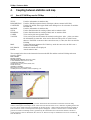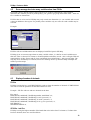
1
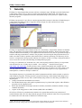
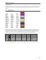
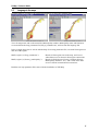
PX-Map - Producer’s Guide
Content
Summary.................................................................................................................................................. 3
Statistical data................................................................................................................................................. 3
Map (coordinate) data..................................................................................................................................... 4
Map.ini-file....................................................................................................................................................... 4
Language ........................................................................................................................................................ 4
1.
Generally.......................................................................................................................................... 5
2.
PX-files............................................................................................................................................. 6
2.1 The key word MAP ................................................................................................................................. 6
2.2 Regional codes....................................................................................................................................... 6
2.3 Own statistical data - text files (SDV) ..................................................................................................... 7
3.
Map basis – shape files.................................................................................................................... 8
3.1
3.2
3.3
3.4
4.
In general................................................................................................................................................ 8
Map parameter file.................................................................................................................................. 8
Requirements for regional codes in the map data .................................................................................. 9
Colour codes ........................................................................................................................................ 10
Coupling between statistics and map ............................................................................................. 11
4.1
4.2
4.3
4.4
Use of PC-AXIS key word in PX-Map................................................................................................... 11
Error message due to too many variable values from PX-file............................................................... 12
Display of number of decimals.............................................................................................................. 12
Special symbols in PX-files................................................................................................................... 13
5.
Option file - PXO ............................................................................................................................ 14
6.
Language ....................................................................................................................................... 16
6.1 Language in PX-Map............................................................................................................................ 16
6.2 Producing own language file................................................................................................................. 16
6.3 Language in the maps .......................................................................................................................... 17
7.
Batch .............................................................................................................................................. 18
8.
Installation ...................................................................................................................................... 19
8.1 System requirements and installation................................................................................................... 19
8.2 File placing ........................................................................................................................................... 20
8.3 interplay with PC-AXIS ......................................................................................................................... 20
Annex 1:
Example of a PX file........................................................................................................... 22
Annex 2:
Language file ..................................................................................................................... 23
PX-Map - Producers Guide
Preface -introduction
This documentation contains the necessary information needed in order to install and adjust PX-Map,
including the relation between data files and map basis.
PX-Map is developed according to requirement specifications prepared by Statistics Norway (SN).
The program is developed by the consulting firm Geodata AS. SN has all rights to application and
source code.
This documentation is among other things based on system and operation documentation worked out
by Geodata AS.
See also other documentation:
• PX-Map Users Guide (User manual)
• PX-Map System and operating documentation
• other documentation on PC-AXIS
Oslo, 25 May 2002
Revised:
December 2002
February 2003 - translated to English
April 2003 - minor corrections
Lars Rogstad
Statistics Norway
----------------------------------------------------------------------------Further work will be carried out on this documentation. Tasks of interest are:
•
•
•
•
document algorithms for classification distribution in shaded maps and symbol sizes in symbol
maps
go through all examples
various formulations – improve language and explanations
conversion to HLP-file
SN is grateful for all types of comments – about PX-Map in general and to this documentation
especially. Please contact:
Marianne Vik Dysterud, telephone + 47 6288 5311, or e-mail [email protected].
Arne Knut Ottestad, telephone + 47 21 09 44 53, or e-mail [email protected].
Statistics Norway
P.O. Box 8131 Dep.
N-0033 Oslo
NORWAY
2
PX-Map - Producers Guide
Summary
PX-Map is a tool for presenting statistical data as thematic maps. PX-Map is a map module within the
PC-Axis software family. It is simple to make a map. But to make a good map is a challenge. A good
map must be true to the data it presents, it must be easy to read and be nice looking. When using PXMap in a sensible way, you will get higher value from your data.
Install PX-map on your computer, and explore the sample data in the PX-Files folder (Norway, Nordic
Countries, Europe, China). Se the User's Guide (in the PX-Map program folder) for more information.
PX-Map is developed by Statistics Norway.
Statistical data
You may present your own data in the maps. PX-Map can read PX-files and semicolon-delimited textfiles. PX-file is an information rich file format used by the PC-AXIS program family. PX-files can be
created from scratch with the program PX-Make.
Semicolon delimited text-file (SDV-file)
Record 1
Record 2
Record 3
etc.
Link to the map you want to use (Ex. Europe_nation.ini). This file is expected to be in
the 'Maps' folder
Region code, Value name (1), Value name (2), Value name (j), Value name (n)
Code (i), Value (i1), Value (i2),...Value(ij),...,Value(in)
The values in the field 'Region code' have to be identical to the similar values in the map data.
Europe_nation.ini
Ctry_cod; Population growth rate; Rate of natural increase; etc.
AM;0,2;0,4;-0,2;3;1,45;14,7;3798,2
AT;0;0;0;;1,34; ;8082,8
AZ;0,9;1;-0,1;5,2;2;16,6;7949,3
BY;-0,2;-0,4;0,2;7;1,27;11,3;10227
BE;0,2;0,1;0,1;4,4; ; ;10213,8
etc.
PX-files - required key words
PC-Axis can handle statistical files with up to 16 variables. In PX-Map this has been reduced, as user
selections are handled by PC-Axis. The following additional requirements are needed for PX-Map to
understand and handle a PX-file:
One 'geographical variable' that holds at least one value. The key word 'CODES' is mandatory for the
'geographical variable'. From other variables only one variable can hold more than one value.
Ex.
STUB="Region";
HEADING="Statistics";
VALUES ("Region")="Armenia","Austria","Azerbaijan","Belarus","Belgium", etc.
VALUES ("Statistics")="Population growth rate", "Rate of natural increase", etc.
CODES ("Region")="AM","AT","AZ","BY","BE", etc.
MAP ("Region")="Europe_nation.ini";
The key word CODES, for the variable 'region', holds the geographical codes. These values have to be
identical to the similar values in the map data. The key word MAP holds the link to the map you want
to use (Ex. Europe_nation.ini). This file is expected to be in the 'Maps' folder.
3
PX-Map - Producers Guide
Map (coordinate) data
Map data are held in the shape format used by ESRI ArcView. The map has to be a set of regions
described by polygons. Every region has a unique code property, which has to be the same as the
region code in the statistical data. The region code has to be in text (string) format (and not as
number).
Obtain a map, which you are allowed to use. Contact your map vendor, or try these web sites:
• ESRI ArcData online:
http://www.esri.com/data/online/index.html
• Geography Network:
http://www.geographynetwork.com/free.cfm
• Digital Chart of the World: http://www.maproom.psu.edu/dcw/
Map.ini-file
The map.ini-file (ex. Europe_nation.ini) holds the information that links the data to the map.
Example
[MAPS]
NumMaps=1
1=C:\Programfiler\PX-Map\Maps\Europe_nation.shp
[DEFAULT]
SymbCol=colLightYellow
Comment
Number of maps
Path to the map files
StartCol=colLightYellow
EndCol=colRed
NullCol=colWhite
ShowNoData=1
Default colour for symbols in symbol
maps
Default start colour for choropleth maps
Default end colour for choropleth maps
Default colour for NIL values
1: Show NIL values, 0: Do not show
[FIELDS1]
MapName=Europe
KeyField=Ctry_cod
KeyPField=ISI code
NameField=Country
NamePField=Country
StatPField=Data
Show=1
Size=1
Color=colDarkGray
Presentation name for Map no. 1
Map key field for region code
Presentation text for KeyField
Map name field
Presentation text for Name Field
Presentation text for data
Show outline for map polygons
Line size for outline
Colour for outline
Language
All text in PX-Map can be viewed in an unlimited number of languages. Default is English, and in
order to work with PX-Map in another language, start PX-Map with the language parameter /l
LanguageTextFile:
Ex.: PX-Map.exe /l <path>pxmapFR.txt
(French)
To make this work you need to have a simple windows text file named <pxmap>" &
<LanguageCode>, where LanguageCode is:
en
fr
es
pt
etc.
English
French
Español
Português
Other language codes are defined by ISO-639.
Make your own language file
Copy the file pxmapEN.txt (English language) found in the PX-Map program folder. Rename the file
with your Language Code, and translate the file.
4
PX-Map - Producers Guide
1.
Generally
PX-Map is a map program that presents statistics as thematic maps. PX-Map can make shaded and
symbol maps, and it is easy to choose colours and classification distribution. The maps may be
presented with symbol explanation and title, and finished maps can be printed or copied to other
Window programs.
PX-Map can present PC Axis files or comma-separated files on maps in the form of shaded maps or
symbol maps. PX-Map presents a suggestion for the design of a map, and users have many
possibilities to adjust this:
PX-Map is a supplement to the solutions in the "PC-Axis-family", and presents statistics as thematic
maps. The program is developed with a simple and user-friendly interface, which at the same time
contains sufficient functionality to cover different needs and user areas, and no special knowledge of
statistics and map presentation is needed. The program is also developed with professional users in
mind, users that are able to produce tailor-made basis for statistics and maps. PX-Map may also be
used as a component in other program solutions, for instance on Web. PX-Map is integrated with PCAxis, but can also be used as freestanding and independent program.
PX-Map is a continuance of "Statistisk sett", and is developed by Statistics Norway in cooperation
with GEODATA AS. PX-Map may be loaded – free of charge 1 – from SN's home pages
(http://www.ssb.no/pxmap/), and the software comes with documentation and example data for
Norway, Scandinavia and Europe (both statistics and map basis). PX-Map is an open system so the
user may make use of his own statistics and map data, for instance parts of a city, regional areas,
municipalities, countries in Europe or whatever.
The finished maps may be presented with symbol explanation and title, and be printed or copied to
other Window programs. PX-Map presents a proposal for design, which among other things are to
secure the most possible correct, and a reader-friendly map, but the user has many possibilities for
adjusting this:
• Change classification distribution and colours
• The finished theme map (and symbol explanation) may be printed and copied to other Window
programs via the clipping board.
• Show data distribution and simple statistical variables (maximum, minimum, median, average,
standard deviations)
• exports of the map picture to other formats (BMP, PNG and WMF)
SN will use PX-Map in communication solutions for regional data and for own production of
statistical theme maps. We also hope that the program will be useful for other users of regional data,
for instance the ones who want to make their own theme maps.
1
This is the case for countries that have an agreement with SN about the use of PC-AXIS. These include in
addition to Norway among others the Nordic countries, Spain, Estonia and others.
5
PX-Map - Producers Guide
2.
PX-files
PX-file is the data format used by PC-AXIS. The file format is documented in "System Manual. PCAXIS for Windows 95/98/NT Version 2000" (contact SN about this one). In annex 1 there is one
example of a complete PX-file. The PX format is a straightforward ASCII-format that may be edited
in a common text editor.
PX-files that are to be used in PX-map must contain one (and only one) regional variable. In addition
the file may contain a variable with several values.
2.1
The key word MAP
The key word MAP is used in PX files to secure the communication between the PX-file and the map
program X-Map.
The syntax for this key word is as follows: MAP("<Variabel>")="<text>";
The key word MAP must be placed after the key word that defines the regional variable in the PXfile2, and it is a sound rule to place it after the key words STUB and HEADING:
STUB="år","kommune";
HEADING="nøkkeltall";
MAP("kommune")="Norway_municipality";
Example:
MAP("kommune")="Norge_kommune";
<Variable>
The name of the variable in the PX-file that contains the regional codes in the
PX-file. Must be written exactly the same way, also lower/upper case letters.
<tekst>
The content in <tekst> is to consist of one link that shows the pertinent
geographical area it covers (for instance country), and one link that shows
regional level (classification). This text string is a pointer to the map parameter
file that steers the linking between statistics and map, and that decides the
appearance of the maps.
NB! This file (Norge_kommune.ini) MUST lie locally on the MAP catalogue
where the program is installed (for instance C:Programfiler\PX-Map\Maps)
Examples of key word MAP
MAP("region")="Norge_kommune"
MAP("region")="Norge_fylke"
MAP("region")="Oslo_bydel"
MAP("region")="Hedmark_grunnkrets"
MAP("region")="Denmark_municipality"
MAP("region")="Nordic_municipality"
MAP("region")="Europe_nation"
MAP("region")="Europe_NUTS2"
2.2
- municipal data for Norway
- county data for Norway
- neighbourhood data for Oslo
- regional data for Hedmark county
- municipal data for Denmark
- municipal data for the Nordic countries
- national data for Europe
- NUTS2-data for Europe
Regional codes
In the PX-file the regional codes are to be stated in the key word CODES. The example shows
municipal data for Norway.
Example
VALUES("kommune")="Halden","Moss", "Sarpsborg", "Fredrikstad", etc.
CODES("kommune")="0101","0104","0105","0106", osv.
2
This requirement concerns PC-AXIS for the reading of PX-files, but not for PX-Map for opening PX-files.
6
PX-Map - Producers Guide
2.3
Own statistical data - text files (SDV)
PX-Map is able to read semicolon-separated text files (SDV-files). Text files do not need to have the
surname SDV; this is decided by the user through adjustments in the language file. For instance
OpenFilter=px, sdv, txt, pxo, asc, dat.
A text file example -county data for Norway
Norge_fylke.ini
Region;Portion pensioners 1996
01;15.1
referral to the map basis, that means the pointer to kart.ini-fil (see key
word MAP for PX-files)
Field name – for regional code and for statistical data, in this case only
one field
Values, separated with semicolon.
First county number, then value for portion pensioners
02;11.0
03;14.4
04;17.4
05;16.6
- etc.
18;14.5
19;12.2
20;10.8
Comments
• fields should be separated with semicolon (;)
• the content of the field for regional code (KNR) must be the same as in the map basis, but not
necessarily the same field name
• decimal symbol – both comma or period may be used
• not necessary with semicolon after each row (but all right)
• must be values in all rows, i.e. either a number, an interval or a special symbol
• may well be not stated/stated as blank (interval)
• necessary with line feed after the last row/line!
7
PX-Map - Producers Guide
3.
Map basis – shape files
3.1
In general
PX-Map uses map data in ESRIs shape format3.
The shape format consists of (minimum) three files, all with the same name, but different file type.
PX-Map needs all three files in order to function – do not touch them!
Example
norge_fylke.shp
norge_fylke.dbf
norge_fylke.shx
Main file, map data, coordinates
dBase-file, with codes and possibly data for the map objects
Index file
PX-Map is delivered with the following map basis:
• Norway – counties, economic regions, municipalities, neighbourhoods in Oslo and Bergen
• Nordic countries – country, counties and municipalities – may be downloaded separate from
www.ssb.no/px-map
• Europe – country and NUTS2
• World – country
This is a map basis which may be freely used together with PX-Map, but remember to state source
(Norwegian Mapping Authority – and the Nordic data).
New map basis may be added dependent on which statistical data are to be shown. Requirements for
new map basis are as follows:
1. A map parameter file must exist in the sub-catalogue MAPS in the installation of PX-Map, one
that points to the pertinent map basis.
2. The map basis must have a common connector key that (regarding content) corresponds to the
statistical data.
If you need other map basis contact your local dealer of GIS and/or map data. You may also try the
Internet – possible addresses are for instance:
• ESRI ArcData online:
http://www.esri.com/data/online/index.html
• Geography Network:
http://www.geographynetwork.com/free.cfm
• Digital Chart of the World: http://www.maproom.psu.edu/dcw/
3.2
Map parameter file
The link between statistics and map data is steered by a map parameter file, for instance
Norge_kommune.ini. (see also chapter 2.1 about key word MAP). This parameter file is also steering
the default values for the colours in the shaded and the symbol maps, language and descriptions in the
maps and the background values for some of the map data.
The map parameter file Must lie locally on the MAPS catalogue where the program is installed (for
instance. C:\Programfiler\PX-Map\Maps)
Possibilities with adjustments in parameter file:
• placing (storage) of coordinate data on local disc
• default minimum and maximum colours for shaded map
• default colour for symbol map
• contour (thickness of line and – colour) for polygons in the map basis
• presentation of supplementary map basis – thickness of line and – colour
• ZERO values – presentation on the map (the ZERO concept – other concepts to be chosen in the
language file)
3
Pertinent software using this format are for instance ArcView and ArcInfo. Many GIS software packages may
be converted to and from shape format.
8
PX-Map - Producers Guide
•
•
name of map basis – the map name that is shown in PX-Map
values for background texts on status line – for instance name of municipality and number,
statistical field
Field
[MAPS]
NumMaps=4
1=C:\Programfiler\PX-Map\Maps\norge.shp
2=C:\Programfiler\PX-Map\Maps\norge_sor.shp
3=C:\Programfiler\PX-Map\Maps\norge_nord.shp
4=C:\Programfiler\PX-Map\Maps\norge_delt.shp
E1=C:\Programfiler\PX-Map\Maps\norge_fylke.shp
E2=C:\Programfiler\PX-Map\Maps\norge_sor_fylke.shp
E3=C:\Programfiler\PX-Map\Maps\norge_nord_fylke.shp
Description, comments
Number base maps that are to be shown – must be polygons
Path and name for map basis for base map no. 1 (entire Norway)
Path and name for map basis for base map no. 2 (Southern
Norway)
- etc.
Path and name for supplementary map parts in map no. 1. (for
instance county borders) – may be polygons or lines
- etc.
[DEFAULT]
SymbCol= colLightYellow
StartCol= colLightYellow
EndCol=colRed
NullCol=colWhite
ShowNoData=0
Default values – colours in maps
Colour for circle symbols
Colour for starting colour, shaded maps
Colour for end colour, shaded maps
Colour for zero values
0: Do not show class for no data; data missing
1: Swow no data; data missing
[FIELDS1]
MapName=Norge
Size=1
Color=colGray
Information on map basis no. 1
Name of maps that are to be shown in PX-Map
If not stated the name of the shape file is given
Key field for connection, points to the pertinent field in map
basis (dbf-fil). Must be text (string) format in Arc View.
Is not case-sensitive, but must have the same name. Need not be
the first field in the shape file.
Presentation field for the key field, i.e. the filed name that is
shown on the status line in PX-Map.
Field name for regional name – points to pertinent field in the map
basis (dbf-fil)
Is not case-sensitive, but must have the same name.
Presentation field for region, i.e. the field name that is shown on
the status line in PX-Map.
Presentation field for statistics
Display of contour (out-line) for polygons:
1: Displayed
0: Not displayed
Line thickness on contour
Colour of contour
[E1]
Size=1
Color=colBlack
Supplementary map layer, for instance other adm. boundaries
Line thickness of contour
Colour of contour
[FIELDS2]
MapName=Sør-Norge
Next map layer … etc.
KeyField=KNR
KeyPField=Kommunenr
NameField=KOMMNAVN
NamePField=Kommunenavn
StatPField=Statistikk
Show=1
[E2]
Size=1
[FIELDS3]
MapName=Nord-Norge
3.3
Requirements for regional codes in the map data
Special map data that are to be used must as a minimum have the following fields:
• field for regional code – MUST be of the type text ('String' in ArcView terminology) 4
• field for regional name – must be of the type text
The field names for regional code and – name must correspond to the appurtenant field names in the
4
It is probably also a maximum length for the field name, but this has not been checked.
9
PX-Map - Producers Guide
map parameter file.
The field names need not be identical to the corresponding field name in the PX or the SDV file. But
the content in the field for the regional code must be identical to appurtenant values in the PX or the
SDV file.
3.4
Colour codes
A set of predefined colour codes from MapObjects LT is used, and are as follows:
ColBlack
ColRed
ColGreen
colBlue
colMagenta
colCyan
colWhite
colLightGray
colDarkGray
colGray
colPaleYellow
colLightYellow
colYellow
colLimeGreen
colTeal
colDarkGreen
colMaroon
colPurple
colOrange
colKhaki
colOlive
colBrown
colNavy
0x0
0xFF
0xFF00
0xFF0000
0xFF00FF
0xFFFF00
0xFFFFFF
12632256
4210752
8421504
13697023
8454143
65535
12639424
8421440
16384
128
8388736
33023
7051175
32896
4210816
8404992
Black
Red
Green
Blue
Magenta
Cyan
White
LightGray
DarkGray
Gray
Pale Yellow
Light Yellow
Yellow
Lime Green
Teal
Dark Green
Maroon
Purple
Orange
Khaki
Olive
Brown
Navy
In addition you may use colours that are described with RGB in a calculated form from HEX to DEC.
The sequence of the RGB values is changed to Blue Green Red (BGR) and hexadecimals are put
together in this sequence. 0 lowest value and therefore no colour and FF (255) highest value and is
therefore a full or pure colour. The calculation may be illustrated in the following matrix:
Colour
(B)ue HEX
(G)reen HEX
(R)ed HEX
HEX
DEC (PXO file)
Red
00
00
FF
FF
255
Green
00
FF
00
FF00
65280
Blue
FF
00
00
FF0000
16711680
Yellow
00
FF
FF
FFFF
65535
Orange
33
99
FF
3399FF
3381759
It is recommended that PX-Map is used to set colours and that user does not key codes for colours.
10
PX-Map - Producers Guide
4.
Coupling between statistics and map
4.1
Use of PC-AXIS key word in PX-Map
PC-AXIS and PX-Map use the following key word from the PX-file5:
TITLE
DESCRIPTION
CONTENTS
MATRIX
STUB
HEADING
CODES
VALUES
MAP
DECIMALS
DATA
Used for information in window title.
Used for field Description when in File/Open (shows content in PX-file)
Used by PC-AXIS, in the upper field in the dialogue box for selection of variables
from PX-file
Used for information in window title.
Used to find direction for reading of data, and/or statistics field.
Used to find direction for reading of data, and /or statistics field.
To be read to pick out regional values.
To be read to pick out file names for statistics and regions. Also – picks out values
for information in status bar. Also used to find out if the px file is valid. If more
than two VALUES occurrences have more than one (1) value, the file is invalid for
PX-Map.
Used to find map parameter file. If this key word does not exist, the file is not a
valid file for PX-Map.
Number decimals to be displayed.
Actual statistics data
The example below shows the interaction between the PX-file and the result in PX-Map after start
from PC-AXIS::
Data in PX-file:
MATRIX="000399";
DESCRIPTION="Nøkkeltall. Kommune. 1999";
TITLE="Nøkkeltall etter kommune. 1999";
CONTENTS="Nøkkeltall";
UNITS="Antall pr. km2, prosent, antall, km2";
STUB="kommune";
HEADING="nøkkeltall";
MAP("kommune")="Norge_kommune";
VALUES("kommune")="Halden","Moss","Sarpsborg", osv.
5
Rewrite or supply this chapter with systematic information about the different elements in the PX-Map
window, Description in File/Open. In the status line at the bottom of the screen , differnces regarding the PX-file
are read via PC-AXIS or directly in PX-Map. In the map picture – rather read title from Description instead of
Title? In the list of files in File/Open the Description is displayed – and use Contents if Desc. is blank. Rather
generate own Title in PX-Map? Title is generated by PC-AXIS based on Contents and variables, and insert
words in between such as distributed, after, and so on. The title in may be insufficient if texts are read directly
from the PX-file.
11
PX-Map - Producers Guide
4.2
Error message due to too many variable values from PX-file
PX-AXIS is able to handle statistics files with up to 16 variables ('dimensions'). One example
illustrates this: Number persons by municipality, year, gender, age group and marital status – these are
five variables or dimensions.
PX-files that are to be used in PX-Map may only contain one dimension (i.e. one variable with several
values) in addition to the region. For possibly other variables only one value for each variable may be
selected.
Example:
PX-files with several dimensions are not displayed with File/Open in PX-Map
PX-Map gives an error message about too many variable values, i.e. that for several variables more
than one value is selected. For instance, all municipalities and all key words – this is all right. With all
municipalities, all key figures and all years (and thereby three dimensions) – this is not all right. The
map key in PC-AXIS may be selected, but an error message shows up from PX-Map if attempts are
made to produce maps:
4.3
Display of number of decimals
PX-files
PX-Map is using the key word PRECISION in order to show the number of decimals. If PRECISION
does not exist for the pertinent variable DECIMALS is used.
Example – PX-file with one and two decimals in the data
Key word:
PRECISION("nøkkeltall","Befolkningstetthet, antall/km2")=2;
PRECISION("nøkkeltall","Befolkning 0-14 år i prosent")=1;
PRECISION("nøkkeltall","Befolkning 15-64 år i prosent")=1;
PRECISION("nøkkeltall","Befolkning 65 år og over i prosent")=1;
DECIMALS=1;
SHOWDECIMALS=0;
SDV-files - text files
PX-Map is using the highest number of decimals that exists in the data. For instance, if a data value
has four decimals, these are used for all data.
12
PX-Map - Producers Guide
4.4
Special symbols in PX-files
PX-Map can handle some special symbols. Special symbols are shown the following way:
Symbol
.
..
Value – meaning
Value – zero
Not stated – blank
Can not occur
Statement lacking
Display in PX-Map
ZERO
ZERO
ZERO
ZERO
13
PX-Map - Producers Guide
5.
Option file - PXO
PX-Map cannot read an option file (PXO-file), or start from the commando line with message to
option file (see chapter 7 - Batch). In the option file a complete set-up of statistics is stored: maps,
class boundaries, colours etc.
The PXO-file can be produced by PX-Map (File/Save as), or also be produced in a text-editing
program. The PXO-file is a straightforward ASCII-file, and may be edited in an ordinary text editor.
The file has the following content (not necessarily with this sequence on the sections):
Section/Field
[DATA]
Source=W:\ssb\Applikasjon\PXFiler\040697.
px
Value=5
Geo=Norge.ini
Map=3
[EXTENT]
Comments
PC-Axis file that is to be used
Which field in the statistics data that is used in the map
PX-Map is using this to approve the file as a valid PX-Map project file
Which file to be used: defined in INI-file
Map segment
All = 0 is the same as complete segment. Other values represent map
coordinates for corner points.
Left=0
Right=0
Top=0
Bottom=0
[SYMBOLIC]
Type=CLASSIFICATION
Map type
Shaded map: CLASSIFICATION, symbol map: CIRCLE
[CIRCLE]
Percent=10
Color=ColPaleYellow
Null=-2
If Type=CIRCLE this should be included.
Percentage size of map basis that the circles should cover.
Recommended value is 10.
Circle value
Value of ZERO in the data set
[CLASSIFICATION]
Null=-2
NullColor=16777215
If Type=CLASSIFICATION this should be included
Value of ZERO in the data set
Colour for ZERO on the map.
Classes=10
RampColors=1
Number of classifications
1: Colours should be distributed between StartColor and EndColor with
the RAMP function
0: Colours are specified for each class
StartColor=ColYellow
EndColor=ColRed
Class1=50
Classification for the highest Value in the class. Therefore lowest value
--50, 51-100 etc..
Class2=100
Class3=200
Class4=400
Class5=800
Class6=1600
Class7=3200
Class8=64000
Class9=128000
Class10=256000
Example of a PXO file for a shaded map:
[DATA]
Source=h:\ROG\PX-Map\Pxfiler\000399.px
Value=1
Geo=Norge_kommune.ini
Map=1
[EXTENT]
14
PX-Map - Producers Guide
Left=-294577.788213315
Right=1332728.54602582
Top=7940077
Bottom=6454100
[SYMBOLIC]
Type=CLASSIFICATION
[CLASSIFICATION]
Null=-2
NullColor=16777215
Classes=5
RampColors=1
StartColor=8454143
EndColor=255
Class1=2.8
Class2=6
Class3=15.3
Class4=46.4
Class5=1543.1
Example of a PXO file for a symbol map:
Explanation – comments
[DATA]
Source=h:\ROG\PX-Map\Pxfiler\000399.px
Value=5
Geo=Norge_kommune.ini
Map=1
Field no. 5 in the PX file
[EXTENT]
Left=-294577.788213315
Right=1332728.54602582
Top=7940077
Bottom=6454100
[SYMBOLIC]
Type=CIRCLE
[CIRCLE]
Percent=10
Color=8454143
Null=244
Corresponds to the colour colYellow
Corresponds to the colour col/White
15
PX-Map - Producers Guide
6.
Language
6.1
Language in PX-Map
All texts (menus, information, dialogue boxes etc.) may be shown in an unlimited number of
languages. This is steered by a special language file that can be called at the start of the program.
Example: PX-Map.exe /l <path>pxmapNO.txt
- PX-Map starts with Norwegian texts
If PX-Map is started without a language file, English texts will appear (that lie default in the exe-file).
From PC-AXIS PX-Map is started with the language that is selected in PC-AXIS. If the pertinent
language file for PX-Map does not exist, PX-Map is started with English texts.
The language file (for instance PXMAPNO.TXT) is a straightforward ASCII-file, where all texts lie in
plain texts.
The language file must have the following name:
PXMAP<LanguageCode>.txt, where LanguageCode is:
sv
en
da
no
fi
kl
is
fo
es
eu
pt
Swedish
English
Danish
Norsk
Suomi
Kalaallisut
Íslenska
Føroyskt
Español
euskara
Português
Other language codes are defined in standard ISO-639.
6.2
Producing own language file
Copy file PXMAPEN.TXT in the PX-Map program catalogue. Rename the file to the new language
code and translate the content of the file:
From:
File=&File
Open=&Open
Save=&Save
SaveAs=Save &As
etc.
To: - other language!
File=&Fil
Open=Å&pne
Save=La&gre
SaveAs=Lagre &som
- where you place & before the shortcut character which will be shown as underlined in menus
The language file is shown in annex 2.
16
PX-Map - Producers Guide
6.3
Language in the maps
PX-Map makes it possible to show different languages in connection with the maps:
Texts for map name, and on the status line (Municipality number, Municipality name and Statistics)
are steered from the map parameter file (Norge_kommune.ini), and not from the language file.
In the example above this is solved with the help of two map parameter files, one with Norwegian text
and one with English:
MAP("region")=(Norge_kommune"):
MAP("region")=(Norway_municipality"):
Results in Norwegian texts in the map, and is used
where data are to be shown in Norwegian connections.
Results in English texts (Norway, Northern Norway,
Municipality, Statistics, etc.), and is used where data
are to be shown in international connections.
Both the two map parameter files come with the installation of PX-Map.
17
PX-Map - Producers Guide
7.
Batch
PX-Map may be started from the commando line, i.e. called with parameters in the following form:
px-map.exe [[/f <inputfile>.<px|pxt|sdv|pxo>] [/m <optionfile>.<pxo>] [/o <outputfile>.<png|wmf|bmp>]]
[/l <languagefile>.txt] [/c circle|choroplet] [/s <number>]
The Parameters' significance:
/f is input file that either could be a PC-Axis file, px/ptx (temporary) or a
semicolon-separated file (sdv).
px-map.exe /f min.px
/m is PX-Maps option file that only can a pxo. If it is a px/pxt or sdv file as input
the pxo file will describe the appearance for the input file in PX-Map. Commando
must at a minimum contain:
px-map.exe /f min.px /m min.pxo
PX-Map can be opened by reading the px-file, all information in the option file and
show map with statistics.
/o is used only for batch jobs that indicate in which format the picture should be
stored. For batch jobs the following calls must be executed:
px-map.exe /f min.px /m min.pxo /o min.png
PX-Map is opened minimized. Reads px-file, all information in the option file and
stores picture for map, symbol explanation, PX file and a pxo file in the same
catalogue as the output file.
/l is a language file that may be of the type PXMAPNO.TXT. If language file is a
part of parameters then all text will be according to the content of the language
file.
/c may either be circle|choroplet that decides if the map is to be a symbol map or
a shaded map.
/s Size of exports of map picture. A value decides the dissolution on the segment.
A dissolution on 1 represents the same number pixler as bitmap picture of the
map the way it looks on the screen. A dissolution of 10 is ten times more than
original number pixler in the map picture, both in horizontal and vertical direction.
0.5 is half of the number of pixler in the map picture.
px-map.exe /f min.px /m min.pxo /o min.png /s 0.5
The program can also be executed with a PX-Map option file. The call may therefore only
include the following:
px-map.exe min.pxo
Then PX-Map will start and read all information from the option file and produce the
theme map. A PXO file can therefore be opened as a document for PX-Map.
18
PX-Map - Producers Guide
8.
Installation
8.1
System requirements and installation
Requirement for hardware
The following configuration is recommended by GEODATA AS:
Product
Processor
Hard disk
RAM
Display card
Minimum configuration for
complete installation
Intel PII-200MHz
53 Mb
64 Mb
2 Mb, 256 colours
Recommended
Intel PII-450MHz
100MB
128 Mb
4 Mb, >256 colours
Complete installation requires 53 MB free hard disk, of which 5.5 MB are needed for PX-Map
software and 47.5 MB on system disk for system files. Reduced installation requires 23 MB free hard
disk, of which 5.5 MB are needed for PX-Map and 17.5 MB on system disk.
Available operating system
PX-Map is available on the following operating system:
• Windows NT 4.0, service pack 5 or higher
• Windows 95
• Windows 2000
• Windows ME
• Windows XP
PX-Map is NOT available for Windows 98.
Installation
Be aware of that you need admintrative privileges on your computer to install the software. If PX-Map
previously is installed on the machine the first step will be to deinstall the previous version. The
installation itself is started by starting the installation script one more time.
The installation is made with InstallShield Professional 6.2 (2000). Two variables are produced:
• complete installation – including BDE 5.11 and MDAC 2.5 – 21.7 MB
• reduced installation – without BDE and MDAC – 8,5 MB
Complete installation
An installation with all necessary components has been produced:
• MDAC 2.5
• BDE 5.11
• MFC 6.0
• Visual Basic Runtime 6
• MOLT 2.0
• PX-Map
Here – the versions of the operating system that are to be used are checked. For Windows NT the
service pack 5 or higher must be installed. For Windows 2000 and ME – MDAC 2.5 is not being
installed because it comes with the operating system..
A complete installation needs a minimum of 53 MB available hard disk where 5,5 MB is needed for
PX-Map and 47.5 MB on system disk.
Reduced installation
An installation with fewer components is made in order to reduce the size. MDAC 2.5 and BDE 5.11
are removed from the installation, but in order for PX-Map to function these must have been installed
19
PX-Map - Producers Guide
on the machine beforehand. User will get a warning about this if one or both are lacking.
The components that are included in reduced installation are:
• MFC 6.0
• Visual Basic Runtime 6
• MOLT 2.0
• PX-Map
A reduced installation requires a minimum of 23 MB available hard disk where 5.5 MB are needed for
PX-Map and 17.5 MB on system disk.
Sequence for installing PX-Map and PC-AXIS
PC-AXIS must be installed before PX-Map due to overwriting of – or new PCAXIS-inifile
(c:\winnt\pcax2000.ini)
Simple system description
The program is built up by several components. The interface is developed in Visual Basic 6.0 service
pack 4 (VB 6.0). Map motor is MapObjects LT 2.0 from ESRI. Some UML documents have been put
up in order to illustrate the different classes and objects in the solution.
PX-Map is using numerous ActiveX components. Most of them are standard components delivered
from Microsoft. ESRI is the deliverer of the component MapObjects LT 2.0 – a component for
handling geographical information.
In addition GEODATA AS has made modules based on ESRI's technology in order to display symbols
on maps, and generate dbf file from px/sdv files. ActiveX DLLs and AcitveX checks that are used in
PX-.Map are developed.
Components that carry out the database work for PX-Map are developed, in this case DBase-files.
PX2DBFBuilder is an ActiveX DLL that is developed in connection with PX-Map. It is described in
the Self-produced ActiveX check and library chapter. The others are Microsoft Active Data Access
Objects that are handling links with databases. PX-Map and the developed components are using
ADO, which is a part of MDAC_TYP library to Microsoft.
PX-Map has one requirement regarding catalogue structure that is needed in order for the program to
operate. A catalogue with the name PX-Map/maps that is to contain map basis and map parameter
files must be available.
8.2
File placing
The map parameter file (for instance Norge_kommune.ini) MUST be stored in the MAPS catalogue
where PX-Map is installed (for instance C:\Programfiler\PX-Map\Maps\). In the map parameter file
references to the placing of the actual map basis is stated. As default in the installation program this
path is put to the same catalogue (C:\Programfiler\PX-Map\Maps\), but user may change this if a
different placing is desired.
If you use something else than Norwegian Windows, or choose to install PX-Map in another catalogue
than default, you MUST change the file placings in the map parameter basis correspondingly. The
path in the map parameter file must be edited to where the map basis is placed.
Statistics data (PX and text files) may be placed where the user wants them.
8.3
Interplay with PC-AXIS
Current version of PC-AXIS (that inter alia exist on SN's web site) is adjusted to use together with PXMap.
20
PX-Map - Producers Guide
Adjustments in PC-AXIS
During the installation of PX-Map the following text is written to ini-fil (c:\winnt\pcax2000.ini) for
PC-AXIS:
[PXMAP]
Pgm=C:\Programfiler\PX-Map\PX-Map.exe
Pathtxt=D:\Programfiler\PX-Map
21
PX-Map - Producers Guide
Annex 1: Example of a PX file
CHARSET="ANSI";
AXIS-VERSION="99";
CREATION-DATE="19990422";
SUBJECT-AREA="00 Generelt";
SUBJECT-CODE="00";
MATRIX="000399";
DESCRIPTION="Nøkkeltall. Kommune. 1999";
TITLE="Nøkkeltall etter kommune. 1999";
CONTENTS="Nøkkeltall";
UNITS="Antall pr. km2, prosent, antall, km2";
STUB="kommune";
HEADING="nøkkeltall";
MAP("kommune")="Norge_kommune";
VALUES("kommune")="Halden","Moss","Sarpsborg","Fredrikstad","Hvaler","Aremark","Marker","Rømsk
og","Trøgstad","Spydeberg","Askim", osv. ;
VALUES("nøkkeltall")="Befolkningstetthet, antall/km2","Befolkning 0-14 år i
prosent","Befolkning 15-64 år i prosent",
"Befolkning 65 år og over i prosent","Folkemengde i alt","Areal i alt med innsjøer, km2";
CODES("kommune")="0101","0104","0105","0106","0111","0118","0119","0121","0122","0123","0124",
"0125","0127","0128","0135","0136","0137","0138","0211", osv. ;
PRESTEXT("nøkkeltall")=0;
PRECISION("nøkkeltall","Befolkningstetthet, antall/km2")=2;
PRECISION("nøkkeltall","Befolkning 0-14 år i prosent")=1;
PRECISION("nøkkeltall","Befolkning 15-64 år i prosent")=1;
PRECISION("nøkkeltall","Befolkning 65 år og over i prosent")=1;
DECIMALS=1;
SHOWDECIMALS=0;
SOURCE="Statistisk sentralbyrå";
DATA=
41.38 18.40 62.80 18.80 26523.00 641.00
416.54 17.60 65.80 16.60 26242.00 63.00
115.78 18.00 65.20 16.80 47122.00 407.00
232.47 18.10 64.70 17.20 67415.00 290.00
39.62 18.20 66.30 15.50 3487.00 88.00
osv.
;
22
PX-Map - Producers Guide
Annex 2: Language file
Innhold i språkfilen er vist under. Det må ikke oversettes det som står i krokodilleklammer <>.
[PXMAP]
#Don't translate words in <>
About=&Om PX-Map
AboutDescription=10
AboutDescription1=PX-Map er en kartmodul i PC-AXIS for
tematisering av kart.
AboutDescription2=PX-Map er også et frittstående produkt
som kan lese PX-filer og ASCII semikolon separerte
filer.
AboutDescription3=
AboutDescription4=Copyright Statistisk Sentralbyrå 2001
AboutDescription5=Statistisk Sentralbyrå
AboutDescription6=Postboks 8131 Avd.
AboutDescription7=0033 Oslo
AboutDescription8=
AboutDescription9=Lars Rogstad, [email protected]
AboutDescription10=www.ssb.no/px-map
Cancel=&Avbryt
CantCreatePXO=Kan ikke lage PX-Map opsjonsfil
CantShowField=Kan ikke vise <FIELD>.
Chart=&Vis datafordeling
CheckINI=Sjekk feltnavnene i <INI> og <SHAPE> (shapefil), som må være identiske.
CircleColorTxt=Symbolfarge
CircleColorCmdTxt=&Endre farge
CircleSizeTxt=Symbolstørrelse
CircleSizeDescTxt=Skriv inn ny prosent:
CircleSizeInfoTxt=Normalt er symbolets areal 10% av
arealet for regionene i statistikkartet.
ClassForm=Temakart
Close=&Lukk
Codes=Kan ikke finne koder for
Connect=Kan ikke åpne database
ConnectDB=Kan ikke koble statistikk og kart.
Contents=&Hjelp for PX-Map
Copy=Kopier
CopyFiles=Shape-fila <SHAPE> finnes ikke. Sjekk
filnavnene i <INI>.
CopyLegend=Kopier &tegnforklaring
CopyLgdImg=Kopier tegnforklarings&bilde
CopyLgdTxt=Kopier tegnforklaringst&ekst
CopyMap=&Kopier kart
CopyStat=&Kopier statistikk
CopyTitle=Ko&pier tittel
Count=Antall
CustomText=Egendefinert
DateTxt=Dato
DescriptionTxt=Beskrivelse
Edit=&Rediger
EqualText=Like intervaller
Exit=&Avslutt
Export=Eks&port
ExportFilter=Bitmap fil (*.bmp)|*.bmp|Windows Meta fil
(*.wmf)|*.wmf|Portable Network Graphics
file(*.png)|*.png
ExportTitle=Eksporter
FieldError=finnes ikke i <SHAPE> (shape-fil).
File=&Fil
Fileformat=Feil tekstfilformat.
FileNameTxt=Filnavn
FrameClassesText=Antall klasser
FrameColorText=Fargerampe
FrameMaximumTXT=Maksimum verdi
FrameTypeText=Klassifiseringstype
FullExtent=&Fullt utsnitt
GenErrorMsg=Det oppsto en feil! Sjekk dataene og utført
operasjon.<CRLF>Det er mer informasjon i Loggfil
Greater=Tallet kan ikke være større enn eller lik
GreaterMin=Tallet kan ikke være større enn
Help=&Hjelp
Info=&Informasjon
InUse=Kartdata er i bruk av en annen prosess. Vær
tålmodig og vent til kartet er ferdig tegnet!
InZoom=Trinnvis zoo&m inn
Join=Kan ikke koble tabellene
LabelEndText=Slutt
LabelStartText=Start
Less=Tallet kan ikke være mindre enn
MapType=Velg karttype
Max=Maks
Maximum=Maksimum
Mean=Gj.snitt
Median=Median
Min=Min
Minimum=Minimum
Missing=Mangler PX-Fil!
MissingData=Mangler numeriske data.
MissingFile=Mangler fil
Navigate=&Navigasjon
NoData=Ingen data
NoDataCheckText=Vis 'Ingen data'
NonNumeric=er ikke et numerisk felt. Kan ikke kalkulere
data!
NumApps=For mange applikasjoner kjøres på engang!
NumFiles=Antall filer
OK=&OK
Open=Å&pne
OpenFilter=px,sdv,txt,pxo
OpenTitle=Åpne
OutZoom=Trinnvis &zoom ut
Pan=&Panorer
Percent=Prosent
PrevExtent=Forrige &utsnitt
Print=Skriv &ut
PrintTitle=Skriv ut
Progress=Mangler Progressbar!
PXMapFile=PX-Map opsjonsfil
QuantileText=Kvantil
RadioChoroplet=Skravurkart - for relative verdier
(forholdstall, andeler, prosenter)
RadioSymbol=Symbolkart - for absolutte verdier (totaltall)
SaveAs=Lagre &som
SaveasTitle=Lagre som
SaveFilter=PX-Map fil (*.pxo)|*.pxo
SizeTxt=Størrelse
StdDev=Stnd. avik
Sum=Sum
SymbolMax=Største symbol
SymbolMin=Minste symbol
TabSymbol=Symbolkart
TabThematic=Skravurkart
Theme=&Temakart
Unavailable=er utilgjengelig
UnJoin=Kan ikke koble fra tabellene
Valid=Ikke gyldig fil for PX-Map!
Values=Kan ikke finne verdier for
Variable=Kan ikke lage kart, det er valgt for mange
variabelverdier.<CRLF>Du kan kun velge flere verdier
fra en variabel<CRLF>(i tillegg til region-variablen), for
øvrige<CRLF>variabler kan du kun velge en verdi.
Version=Versjon
View=&Vis
WrongExtension=Feil filetternavn
WrongNumber=Feil verdi for value i data- eller opsjonsfila,
benytter den første.
WrongPXO=Feil verdi i PXO fil!
ZoomIn=Zoom &inn
ZoomOut=Zoom &ut
23