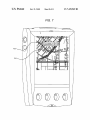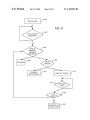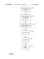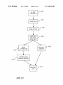
1
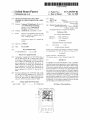
US007439969B2
(12) Ulllted States Patent
Chithambaram et al.
(54)
(75)
(10) Patent N0.:
(45) Date of Patent:
(51)
Int. Cl.
G06T 15/00
CLIENT
(52)
US. Cl. ..................... .. 345/418; 345/619; 715/863;
(58)
Field of Classi?cation Search ............... .. 345/418,
Inventors: Nemmara Chithambaram, Novato, CA
_
_
_
_
345/711, 810, 619, 629; 715/515, 530, 854,
. .
715/863; 701/201; 702/2
See appl1cat1on ?le for complete search h1story.
Subject to any disclaimer, the term of this
patent is extended or adjusted under 35
U.S.C. 154(b) by 0 days.
References Cited
US‘ PATENT DOCUMENTS
4,530,051 A
7/1985 Johnson et 31.
4,843,569 A
6/1989 Sawada et a1.
patent is subject to a terminal dis-
(Continued)
FOREIGN PATENT DOCUMENTS
(21) Appl. N0.: 11/550,497
W0
F1led:
WO 97/07467
Oct. 18, 2006
(65)
701/201; 702/2
DeAguiar, Sebastopol, CA (US)
(56)
Notice:
(2006.01)
Albany CA (Us) John Ricardo
(73) Ass1gnee: Autodesk, Inc., San Rafael, CA (US)
(22)
*Oct. 21, 2008
SINGLE GESTURE MAP NAVIGATION
GRAPHICAL USER INTERFACE FOR A THIN
(Us); Robin Warner Dandridge,
(*)
US 7,439,969 B2
OTHER PUBLICATIONS
Prior Publication Data
US 2007/0080958 A1
2/1997
Apr. 12, 2007
Hinckley etal, Interaction and Modeling Techniques for Desktop
Two-Handed Input, UIST, 1998, San Francisco, ACM, pp. 49-58.*
(Continued)
Related US. Application Data
(63) Continuation of application No. 09/795,890, ?led on
Primary Examineriphu K Nguyen
(74) Attorney, Agent, or Firm4Gates & Cooper LLP
Feb. 28, 2001, noW Pat. No. 7,142,205, and a continu
ation-in-part of application No. 09/629,115, ?led on
Jul. 31, 2000, noW abandoned, and a continuation-in-
part of application NO_ 09/628,850, ?led on JUL 31’
2000’ HOW Pat NO_ 6,67 4’ 44 5’ and a Continuatiomim
ABSTRACT
_
_
_
_
_
_
An appl1cat1on on a thin cl1ent d1splays a map. A graph1cal
user interface permits the application to receive single gesture
part of application NO_ 09/628,851, ?led on JUL 31’
inputs of a stylus. If the single gesture input comprises a drag
2000 HOW Pat NO_ 7 142 196 and a Continuatiomim
of the stylus a minimum distance, the map is panned such that
part sf application N30 0’9/62’9’1 17, ?led on JUL 31’
the map is shifted to a neW center vieW. The displayed map
2000
may contain one or more map objects. If the input comprises
_ _
_
_
a single tap on a speci?c map object, the map object under the
(60) PrOVlslOnal appllcfmon NO- 90/193,862, ?led on Mar-
(30)
(57)
tap may be selected and highlighted. Further, a ToolTip for the
30> 2000: PrOVlslOna1 appl1cat1on NO- 90/193,153’
map object may be displayed. A further tap of the ToolTip
?led 011 Mar- 29, 2000, PFC/“51011a1 appl1cat1on N9
60/193,141, ?led 011 Mar- 29, 2000, PrOVlSlOna1 aPPh'
may result in the navigation to a link or URL associated With
the map object selected. One or more Zoom buttons may also
Canon N0~ 60/193,142, ?led 011 Man 29, 2000
be displayed. If a Zoom button is tapped by the user, the map
may be displayed in a different level of detail.
Foreign Application Priority Data
Sep. 26, 2000
(WO) ................... .. PCT/US00/26436
702
20 Claims, 11 Drawing Sheets
US 7,439,969 B2
Page 2
US. PATENT DOCUMENTS
5,231,584 A
2002/0049742 A1
4/2002 Chan et a1.
_
2002/0085032 A1
7/2002 Fong et al.
7/1993 NlITlum et a1~
2002/0128903 A1
5,528,248
5,543,789
5,559,707
5,564,005
A
A
A
A
6/1996
8/1996
9/1996
10/1996
Stem“ et a1
Behr et a1
DeLOrme et a1
Weber e131
2003/0035003
2004/0237049
2005/0216863
2006/0129937
A1
A1
A1
A1
5,615,384
5,673,421
5,687,254
5,689,431
5,699,244
5,727,159
A
A
A
A
A
A
3/1997
9/1997
11/1997
11/1997
12/1997
3/199g
Allard 6‘ a1~
Sh1rakawa
Poon et a1.
2006/0184887 A1
9/2002 Kernahan
2/2003
11/2004
9/2005
6/2006
Marcos et al.
Pletcher et a1.
Schumacher et al.
Shafron
8/2006 Popp et al.
OTHER PUBLICATIONS
Rudow et al.
(Hark, Jr‘ @131‘
Kikinis
571998 Crawford
ARGU95, Argus User’s Guide 3.0, The Next Generation in GIS,
Munro Garrett International, May 1994, p. 176-180.
SOFT95, Speci?cation for the Simple Vector Format (SVF) v1.1,
5,754,176 A
5,787,300 A
7/1998 wijaya
article, SoftSource, Bellingham, WA, 1995, pp. 1-8.
5,796,406 A *
g/199g shigematsu et a1‘ _______ __ 715/863
XERO95, Map Viewer Technical Details, Xerox Corporation, Jun. 2,
5,809,145 A
5,844, 547 A
5,848,040 A
A
5,848,373
5,910,800
5,912,676
5,938,721
5,966,135
A
A
A
A
9/1998
12/199g
12/1998
12/199g
6/1999
6/1999
g/1999
10/1999
Slik etal.
Minakuchi et a1‘
Tanaka
DeLOrme et a1‘
Shields et a1.
Ma11ad1 @1211‘
Dusse11 et a1‘
Roy 61 a1‘
19913 PP
XERO95, Mapwriter (1) User Commands, Xerox Corporation, Nov.
5, 1993, 4PP~
XERO95, About the Xerox PARC Map Viewer, Xerox Corporation,
Jun- 1993, 1P
wabasoft, “The Waba Virtual Machine,” © 1999, 2000, 2 pgs.
wabasoft, “The Waba Class Library,” © 1999, 2000, 1 pg.
wabasoft, “The Waba Software Development Kit,” © 1999, 2000, 2
5,973,678 A
10/1999 Stewart et al.
PgS~
5,974,431 A
10/1999 11da
wabasoft, “The WARP File FormatiVersion 1.0,” © 1999, 2000, 3
5,995,101 A
11/1999 Clark et a1.
6,040,824
6,057,854
6,083,353
6,104,415
A
A
A
A
3/2()()()
5/2000
7/2000
51/2000
6,108,715
6,124,858
6,156,965
6,166,734
6,182,010
6,192,518
A
A
A
A
B1
B1
8/2000
9/2()()()
12/2000
12/2000
1/2001
2/2001
6,240,555 B1
PgS~
Maekawa 61211‘
Davis, Jr. et al.
A1exander, Jr‘
Gossett
www.wabasoft.com/faq.html, Copyright 1999, 2000, 7 pp.
WWW'WaPaiO, Class Catalog, 1111 2001, 6 PP
M. Potmesil, “Maps Alive: Viewing Geospatial Information on the
WWW,” Computer Networks and ISDN Systems, 1997, 29: 1327
Leach et al.
Ge e1 31‘
Shinsky
Nahi
Berstis
Neal
1342
International Business Machines Corporation. “Markup File for
AsynchroniZed Collaboration on an Image Viewer Application”.
Research Disclosure Datebase No. 418093, Research Disclosure
Journal, ISSN 0374-4353 Kenneth Mason Publications Ltd, Feb.
1999
5/2001 shoff et a1‘
Reilly, Rob. “Desktop Video-Conferencing with George Jetson,”
6,253,326
6,321,158
6,336,072
6,337,693
6,343,290
6,359,633
6,370,449
6,397,259
6,405,226
6,421,453
6,456,938
6,477,575
6,505,242
B1
B1
B1
B1
B1
B1
B1
B1
B1
B1
B1
B1
B2
6/2001
11/2001
1/2002
1/2002
1/2002
3/2002
21/2002
5/2002
6/2002
7/2002
9/2002
1 1/2002
1/2003
Lincke @1211,
DeLOrme @1211‘
Takayama et a1‘
Roy et a1‘
Cossins
Bahsubmmaniam et a1‘
Razavi @1211‘
Lincke et a1‘
A1peI1 e1 31‘
Kanevsky et a1‘
Barnard
Koeppe1 et a1‘
Holland et al.
MultiMedia Schools, p. 78-79, Nov/Dec. 2000.
Microsoft NetMeeting Features. Updated Jun. 2, 1999 http://web.
archive.org/web/19991013123712/microsoft.com/windows/
NetMeeting/Features/Whieboard/defaultasp.
Microsoft NetMeeting Features. Updated Jun. 7, 1999. http://web.
archive.org/web/19991013143705/http://microsoft.com/windows/
NetMeeting/Features/default.asp.
Microsoft Corporation. “Resource Kit Copyright Information”
Updated Dec. 15, 1999. http://www.microsoft.com/windows/
NetMeeting/Corp/reskit/Copyright/default.asp.
“Welcome to Netmeeting 3”. Updated Dec. 20, 2000. http://www.
microsoft.com/windows/NetMeeting/Corp/reskit/Welcome/default.
6,535,743
6,542,813
6,551,357
6,560,620
6,604,046
B1
B1
B1
B1
B1
3/2003
4/2003
21/2003
5/2003
g/2003
Kennedy et a1‘
Kovacs
Madduri
Ching
Van watermmen et 31‘
“NetMeeting 3.0” Updated Jul. 4, 2004. http://www.meetingbywire.
OOH/NetMeetinglhtm
“eZ Questions &Answers”Apr. 1, 2001 http://web.archive.org/web/
6,654,683
6,665,824
6,674,445
6,687,876
6,724,382
6,725,281
6,763,458
B2
B1
B1
B1
B2
B1
B1
1 1/2003
12/2003
1/2004
2/2004
21/2004
4/2004
7/2004
Jin et a1‘
Ruh1en et a1‘
Chithambamm 61211‘
50111111131 31‘
Kenyon et 31‘
Zinte1 et a1,
Watanabe
6,769,019
6,826,473
6,886,170
6,934,628
7,043,362
7,099,771
7,142,205
B2
7/2004
B1
11/ 2004
B1
4/2005
B2
8/2005
B2
5/2006
B1
8/2006
B2 * 11/2006
Ferguson
Burch et al.
Bahrs et al.
Harada
Kl'llll et 31
Walters et a1~
Chithambamm et a1~
7,224,365 B1 *
2001/0050675 A1
5/2007
3511
20010405200856/www.eZmeeting.com/QiAhtml.
Windows NetMeeting Features. Updated Apr. 22, 2004. http://www.
microsoft.com/windows/NetMeeting/Features/default.ASP.
Goodenough eta1., Queries and Their Application to Reasoning with
Remote Sensing and GIS, IEEE, Feb. 1994, pp. 1199-1203.
Drutman et al., Marine Geophysics Modeling With Geographic
Information Systems, IEEE, May 1994, pp. III 528-531.
345/418
Kersting et al., Interactive 3D Visualization of Vector Data in GIS,
GIS’OZ, ACM, NW 2002, PP 107-112
De?nition of map, printed from http://thesaurus.reference.com.
De?nition of “map”, printed from http://encarta.msn.com.
De?nition of “servlet”, printed from http://foldoc.org.
Courter, Masering Microsoft Of?ce 2000, 1999, Sybex, pp. 14-15.
Quo Vadis Version 1.5P User Manual, 1999, pp. 1-19.
Apple Computer Inc., Newton 2.0 User Interface Guidelines, 1996.
Microsoft Paint, Version 4.0, Copyright 1981-1989 Microsoft Corp.
Seideman et al. ......... .. 345/473
12/2001 O’Leary
* Cited by examiner
US. Patent
0a. 21, 2008
Sheet 2 0f 11
US 7,439,969 B2
US. Patent
0a. 21, 2008
Sheet 3 0f 11
US 7,439,969 B2
US. Patent
Oct. 21, 2008
US 7,439,969 B2
Sheet 4 0f 11
300
START UP
1
REQUEST LOAD
OF ACTIVE
WORKSPACE
f
302
l
CREA TE MAP
MODEL
f
304
i
306A —-"
306B ——/
/
/
RE TRIE VE
DA TA
306
CONVEY REQUEST TO
VIEWER SERVICES
l
I 308
DELEGATE REQUEST
TO NET SERVICES
1
1
l
CA CHE DA TA
NO TIF Y
LIS TENERS
FIG.3
UPDA TE
f
310
f
f
312
314
US. Patent
0a. 21, 2008
Sheet 5 0f 11
US 7,439,969 B2
FIG. 4
§OPTIONS
ZOOM IN
NEW NOTE
NEW REDLINE
/' UNDO
DONE
NOV T
402
US. Patent
0a. 21, 2008
Sheet 6 0f 11
FIG. 5
CENTER
MAP
III
US 7,439,969 B2
US. Patent
0a. 21, 2008
Sheet 7 0f 11
FIG. 6
\
602 \
TOOLTIP TEXT
US 7,439,969 B2
US. Patent
0a. 21, 2008
Sheet 8 0f 11
FIG. 7
US 7,439,969 B2
US. Patent
0a. 21, 2008
Sheet 9 0f 11
US 7,439,969 B2
800
DISPLA Y MAP
f
802
STYLUS INPUT
RECEIVED?
YES
804
STYLUS
MOVED A
MINIMUM
4/
PAN MAP
YES
NO
f 806
808
ZOOM
BUTTON
?
!/YES
810
Api-fggAl/aléli TE f
NO\
812
DISPLAY TOOL TIP f
814
ANOTHER
TAP?
YES
816
ON
TOOLTIP?
[\IO
I
YES
NAVIGATETO f 818
LINK, IFANY
US. Patent
Oct. 21, 2008
US 7,439,969 B2
Sheet 10 0f 11
REQUEST NEW
LAYERS
f
900
l
902
CONVEY REQUEST
TO QUERY
PROCESSOR
1
904
CONVEY QUERY TO
VIEWER SERVICES
1
DE CL U TTER
l
f
906
908
ENCODE
l
SEND
RES UL TS
FIG.9
910
US. Patent
0a. 21, 2008
Sheet 11 0f 11
ALTER
US 7,439,969 B2
_f_ 1000
CONTENTS
1
f 1002
l
J- 1004
SAVE KEYS
SA vE STA TE
STARTAPP
AND READ
1006
f
BACK KEYS
READ
REQUEST I
J ATTRIBUTES
101
REPORT
_
FORMATAND
101
2f DISPLAY REPoRT
RESTART f 1014
APP
FIG.10
1008
US 7,439,969 B2
1
2
SINGLE GESTURE MAP NAVIGATION
GRAPHICAL USER INTERFACE FOR A THIN
CLIENT
GRAPHICAL DATA MARKUP ON A PERSONAL DIGI
TAL ASSISTANT (PDA)”, by EdWard J. Connor, et al., ?led
on Jul. 31, 2000, US. patent application Ser. No. 09/628,850,
entitled
“GENERALIZED,
DIFFERENTIALLY
CROSS-REFERENCE TO RELATED
APPLICATIONS
ENCODED, INDEXED RASTER VECTOR DATA AND
SCHEMA FOR MAPS ON A PERSONAL DIGITAL
ASSISTANT”, by Nemmara Chithambaram et al., ?led on
This application is a continuation of and claims the bene?t
Jul. 31, 2000, and US. patent application Ser. No. 09/629,
under 35 U.S.C. Section 120 of the following co-pending and
117, entitled “METHOD AND APPARATUS FOR
OBTAININGA SET OF MAPS”, by HoWard MarantZ et al.,
commonly-assigned U.S. utility patent application, Which is
incorporated by reference herein:
Utility application Ser. No. 09/795,890, ?led Feb. 28,
?led on Jul. 31, 2000.
Utility application Ser. No. 09/795,890 further is a continu
ation-in-part of the folloWing co-pending and commonly
2001, by Nemmara Chithambaram, Robin Warner Dan
dridge, and John Ricardo Deaguiar, entitled SINGLE GES
assigned US. Patent Applications, Which are incorporated by
TURE MAP NAVIGATION GRAPHICAL USER INTER
FACE FOR PERSONAL DIGITAL ASSISTANT, Which
reference herein:
application claims the bene?t under 35 U.S.C. §1 19(e) of the
“METHOD AND APPARATUS FOR PROVIDING
ACCESS TO MAPS ON A PERSONAL DIGITAL ASSIS
US. patent application Ser. No. 09/629,115, entitled
following co-pending and commonly assigned U.S. Provi
sional patent application, Which applications are incorporated
by reference herein:
20
US. application Ser. No. 60/ 193,142, entitled “INTER
PROCESS API AND GRAPHICAL USER INTERFACE
FOR PERSONAL DIGITAL ASSISTANT (PDA) DEVICES
AND APPLICATIONS,” ?led on Mar. 29, 2000, by Nem
mara Chithambaram, et. al.;
25
US. application Ser. No. 60/193,141, entitled “SHAR
entitled “INDEXED RASTER VECTOR SCHEMA FOR
2000, by Nemmara Chithambaram, et. al.;
30
RASTER VECTOR SCHEMA FOR PERSONAL DIGITAL
ASSISTANT (PDA) DATABASES,” ?led on Mar. 29, 2000,
by Nemmara Chithambaram, et. al.; and
US. application Ser. No. 60/ 193,862, entitled
“MAPGUIDE FOR MOBILE DEVICES SERVER,” ?led on
35
Mar. 30, 2000, by Nemmara Chithambaram, et. al.
Utility application Ser. No. 09/795,890 also claims the
bene?t under 35 U.S.C. §120 and 35 U.S.C. §363 of the
co-pending and commonly assigned international patent
application number PCT/US00/26436, entitled “GEO
ABLE REDLINING FOR PERSONAL DIGITAL ASSIS
TANT (PDA),” ?led on Mar. 29, 2000, by Nemmara Chith
ambaram, et. al., US. application Ser. No. 60/193,153
ABLE SERVER UPLOADABLE REDLINING FOR PER
SONAL DIGITAL ASSISTANT (PDA),” ?led on Mar. 29,
US. application Ser. No. 60/ 193,153 entitled “INDEXED
TANT (PDA)”, by Nemmara Chithambaram et al., ?led on
Jul. 31, 2000 Which application claims the bene?t of US.
application Ser. No. 60/ 159,069, entitled “MAPGUIDE
PERSONAL DIGITAL ASSISTANT,” ?led on Oct. 12, 1999,
by Nemmara Chithambaram, et. al., US. application Ser. No.
60/ 193,141, entitled “SHARABLE SERVER UPLOAD
40
PERSONAL DIGITAL ASSISTANT (PDA) DATABASES,”
?led on Mar. 29, 2000, by Nemmara Chithambaram, et. al.,
US. application Ser. No. 60/193,142, entitled “INTERPRO
CESS API AND GRAPHICAL USER INTERFACE FOR
PERSONAL DIGITAL ASSISTANT (PDA) DEVICES
AND APPLICATIONS,” ?led on Mar. 29, 2000, by Nem
mara Chithambaram, et. al., and US. application Ser. No.
60/ 193,862, entitled “MAPGUIDE FOR MOBILE
DEVICES SERVER,” ?led on Mar. 30, 2000, by Nemmara
Chithambaram, et. al.;
US. patent application Ser. No. 09/628,850, entitled
“GENERALIZED, DIFFERENTIALLY ENCODED,
GRAPHIC MAPS ON A PERSONAL DIGITAL ASSIS
INDEXED RASTER VECTOR DATAAND SCHEMA FOR
TANT (PDA) AND SERVER, ?led on Sep. 26, 2000, by
Autodesk, Inc., Which application claims the bene?t under 35
U.S.C. §119(e) of US. application Ser. No. 60/159,069,
TANT,” ?led on Oct. 12, 1999, by Nemmara Chithambaram,
et. al., US. application Ser. No. 60/193,141, entitled “SHAR
MAPS ON A PERSONAL DIGITAL ASSISTANT”, by
Nemmara Chithambaram et al., ?led on Jul. 31, 2000, Which
application claims the bene?t of US. application Ser. No.
60/ 159,069, entitled “MAPGUIDE PERSONAL DIGITAL
ASSISTANT,” ?led on Oct. 12, 1999, by Nemmara Chitham
baram, et. al., US. application Ser. No. 60/193,141, entitled
ABLE SERVER UPLOADABLE REDLINING FOR PER
SONAL DIGITAL ASSISTANT (PDA) MAPS,” ?led on
“SHARABLE SERVER UPLOADABLE REDLINING
FOR PERSONAL DIGITAL ASSISTANT (PDA),” ?led on
entitled “MAPGUIDE PERSONAL DIGITAL ASSIS
Mar. 29, 2000, by Nemmara Chithambaram, et. al., US.
application Ser. No. 60/193,153 entitled “INDEXED RAS
45
50
Mar. 29, 2000, by Nemmara Chithambaram, et. al., US.
application Ser. No. 60/193,153 entitled “INDEXED RAS
TER VECTOR SCHEMA FOR PERSONAL DIGITAL
TER VECTOR SCHEMA FOR PERSONAL DIGITAL
ASSISTANT (PDA) DATABASES,” ?led on Mar. 29, 2000,
by Nemmara Chithambaram, et. al., US. application Ser. No.
60/193,142, entitled “INTERPROCESS API AND GRAPHI
ASSISTANT (PDA) DATABASES,” ?led on Mar. 29, 2000,
by Nemmara Chithambaram, et. al., US. application Ser. No.
60/193,142, entitled “INTERPROCESS API AND GRAPHI
55
CAL USER INTERFACE FOR PERSONAL DIGITAL
CAL USER INTERFACE FOR PERSONAL DIGITAL
ASSISTANT (PDA) DEVICES AND APPLICATIONS,”
?led on Mar. 29, 2000, by Nemmara Chithambaram, et. al.,
and US. application Ser. No. 60/ 193,862, entitled
ASSISTANT (PDA) DEVICES AND APPLICATIONS,”
?led on Mar. 29, 2000, by Nemmara Chithambaram, et. al.,
and US. application Ser. No. 60/193,862, entitled
“MAPGUIDE FOR MOBILE DEVICES SERVER,” ?led on
“MAPGUIDE FOR MOBILE DEVICES SERVER,” ?led on
Mar. 30, 2000, by Nemmara Chithambaram, et. al.; and Which
Mar. 30, 2000, by Nemmara Chithambaram, et. al.;
US. patent application Ser. No. 09/628,851, entitled
international application is a continuation in part of US.
patent application Ser. No. 09/629,115, entitled “METHOD
“GEOGRAPHICAL DATA MARKUP ON A PERSONAL
AND APPARATUS FOR PROVIDING ACCESS TO MAPS
DIGITAL ASSISTANT (PDA)”, by EdWard J. Connor, et al.,
ON A PERSONAL DIGITAL ASSISTANT (PDA)”, by
Nemmara Chithambaram et al., ?led on Jul. 31, 2000, US.
patent application Ser. No. 09/628,851, entitled “GEO
65
?led on Jul. 31, 2000 Which application claims the bene?t of
US. application Ser. No. 60/159,069, entitled “MAPGUIDE
PERSONAL DIGITAL ASSISTANT,” ?led on Oct. 12, 1999,
US 7,439,969 B2
3
4
by Nemmara Chithambaram, et. al., US. application Ser. No.
BACKGROUND OF THE INVENTION
60/ 193,141, entitled “SHARABLE SERVER UPLOAD
1. Field of the Invention
The present invention relates generally to electronic maps
and geographic information, and in particular, to a method,
apparatus, and article of manufacture for navigating a map
displayed on a personal digital assistant (PDA).
2. Description of the Related Art
ABLE REDLINING FOR PERSONAL DIGITAL ASSIS
TANT (PDA),” ?led on Mar. 29, 2000, by Nemmara Chith
ambaram, et. al., US. application Ser. No. 60/193,153
entitled “INDEXED RASTER VECTOR SCHEMA FOR
PERSONAL DIGITAL ASSISTANT (PDA) DATABASES,”
?led on Mar. 29, 2000, by Nemmara Chithambaram, et. al.,
US. application Ser. No. 60/193,142, entitled “INTERPRO
Computer implemented geographic information systems
CESS API AND GRAPHICAL USER INTERFACE FOR
(GIS) are knoWn in the art. Such GIS provide for the retrieval
PERSONAL DIGITAL ASSISTANT (PDA) DEVICES
AND APPLICATIONS,” ?led on Mar. 29, 2000, by Nem
mara Chithambaram, et. al., and US. application Ser. No.
60/ 193,862, entitled “MAPGUIDE FOR MOBILE
DEVICES SERVER,” ?led on Mar. 30, 2000, by Nemmara
Chithambaram, et. al.; and
US. patent application Ser. No. 09/629,117, entitled
and display of geographic information (e.g., maps). A GIS is
a system of softWare, hardWare, and data that delivers geo
graphic data (street maps, property boundaries, poWer trans
mission lines, etc.) along With any associated attribute infor
mation. It can shoW you Where a street is and also tell you the
street name, When it Was last paved, Whether it is a one-Way
“METHOD AND APPARATUS FOR OBTAINING A SET
OF MAPS”, by Nemmara Chithambaram et al., ?led on Jul.
31, 2000, Which application claims the bene?t of US. appli
20
netWork/intemet Wherein the geographic information is
cation Ser. No. 60/ 159,069, entitled “MAPGUIDE PER
SONAL DIGITAL ASSISTANT,” ?led on Oct. 12, 1999, by
stored on a server and transmitted to a client/user Where the
information (map picture and other data) is displayed on a
Nemmara Chithambaram, et. al., US. application Ser. No.
60/ 193,141, entitled “SHARABLE SERVER UPLOAD
ABLE REDLINING FOR PERSONAL DIGITAL ASSIS
Web broWser.
25
TANT (PDA),” ?led on Mar. 29, 2000, by Nemmara Chith
ambaram, et. al., US. application Ser. No. 60/193,153
broWser such as INTERNET EXPLORER or NETSCAPE
30
This application is related to the following co-pending and
commonly-assigned patent applications, Which applications
such that a user does not have to Wait an inordinate amount of
time to retrieve and load the data, an appropriate Internet
35
Field/utility technicians such as gas company employees,
40
tor may Want to determine Where the main gas line or Water
line on a street is located. HoWever, While out in the ?eld, the
45
portable computing device With the capabilities to display and
inson, and Roderick Gaetan Munro, entitled “VECTOR
50
commonly-assigned patent application serial no. 09/41 1,506,
?led Oct. 4, 1999, by Gregory AndreW Roy, Osman Hamid
Bux, Kevin Glen Robinson, and Roderick Gaetan Munro,
US. Pat. No. 6,337,693, issued on Jan. 8, 2002, Which appli
cation is a continuation of commonly-assigned patent appli
cation Ser. No. 08/757,706, ?led on Oct. 30, 1996, by Gre
gory AndreW Roy, Osman Hamid Bux, Kevin Glen Robinson,
and Roderick Gaetan Munro, entitled “VECTOR BASED
GEOGRAPHIC DATA”, now US. Pat. No. 5,966,135, issued
55
interact With geographic information both online and o?lline.
Prior art handheld computing devices (also referred to as
palm PCs or personal digital assistants (PDAs)), are often
used to access and utiliZe personal information. Many hand
held computing devices are available in today’s marketplace.
Typically, handheld computing devices are only slightly
larger than the siZe of one’s palm (hence, the name palm PC)
and have a small display screen for vieWing a plethora of
items. SoftWare can be installed on a PDA to provide
enhanced functionality. For example, a personal productivity
tool may be installed to provide access to a calendar, contacts,
60
email, Internet broWsing, audio books, and audio recording
capabilities. Card slots may also be available to provide addi
on Oct. 12, 1999.
tional memory or other functions (e.g., a modem). Addition
ally, some PDAs have infrared (IR) ports for communication.
Field technicians using a PDA need to vieW, interact, and
US. application Ser. No. 09/795,719, entitled “INTER
PROCESS APPLICATION PROGRAMMING INTER
FACE FOR PERSONAL DIGITAL ASSISTANT APPLICA
technicians often do not have a netWork connection, and
carrying a laptop or desktop computer is cumbersome and
impractical. Thus, it is desirable to have a small (handheld)
Utility application Ser. No. 10/ 008,625, ?led Dec. 6, 2001, by
Gregory AndreW Roy, Osman Hamid Bux, Kevin Glen Rob
entitled “VECTOR BASED GEOGRAPHIC DATA”, now
utiliZe or require access to maps and geographic information.
Further, such technicians often need to interact With a map to
obtain relevant information. For example, a plumber/contrac
Utility application Ser. No. 10/642,857, ?led Aug. 18,
2003, by Gregory A. Roy, Osman H. Bux, Kevin G. Robinson,
BASED GEOGRAPHIC DAT ”, now US. Pat. No. 6,642,
925, issued on Nov. 4, 2003, Which patent is a continuation of
connection (e.g., a 28.8 Kbps (kilo bits per second) modem)
and a computer system With signi?cant processing poWer
(e.g., a minimum speed of 100 megahertZ) may be required.
salespersons, plumbers, insurance adjusters, or any type of
employment that requires travel to different locations, often
are incorporated by reference herein:
and Roderick G. Munro, entitled “VECTOR-BASED GEO
GRAPHIC DATA, Which application is a continuation of
NAVIGATOR and have a minimum of 10 megabytes of avail
able memory. Additionally, to display the geographic data
CESS API AND GRAPHICAL USER INTERFACE FOR
PERSONAL DIGITAL ASSISTANT (PDA) DEVICES
AND APPLICATIONS,” ?led on Mar. 29, 2000, by Nem
mara Chithambaram, et. al., and US. application Ser. No.
60/ 193,862, entitled “MAPGUIDE FOR MOBILE
DEVICES SERVER,” ?led on Mar. 30, 2000, by Nemmara
Chithambaram, et. al.
For the client to properly display the geographic informa
tion, a computer system With the appropriate processing capa
bilities, softWare, and memory is required. For example, a
client may be required to utiliZe a computer With a Web
entitled “INDEXED RASTER VECTOR SCHEMA FOR
PERSONAL DIGITAL ASSISTANT (PDA) DATABASES,”
?led on Mar. 29, 2000, by Nemmara Chithambaram, et. al.,
US. application Ser. No. 60/193,142, entitled “INTERPRO
street, etc. Using a GIS, a user can perform complex queries
(from a Web broWser to a server) to discover such things as
hoW many people live near the street, What their income level
is, and What the Zoning laWs are. A GIS can operate on a
TIONS,” ?led on Feb. 28, 2001, hereWith, by Timothy John
navigate maps displayed. The PDA environment, hoWever,
poses several challenges for geographic information systems
Nelson, et. al.
in terms of map navigation, memory, storage, processor
65
US 7,439,969 B2
6
5
speeds, Wireless transmission rates, and display attributes.
FIG. 6 illustrates a visual representation of a ToolTip in
For example, the screen area of PDAs is typically small (160x
160 pixels) and PDAs commonly only maintain 96K or less of
accordance With one or more embodiments of the invention;
memory, 2 Mb (megabytes) or less storage, a 13 MHZ pro
cessor speed, and a black and White or gray scale display
With one or more embodiments of the invention;
mechanism. Additionally, a stylus takes the place of a multi
button mouse. Map navigation may be particularly dif?cult
graphical user interface in accordance With one or more
embodiments of the invention;
on a PDA since technicians in many instances Work in
trenches or other places Where a user’s range of motion and
FIG. 9 is a How chart illustrating hoW a servlet responds to
requests from client net services in accordance With one or
vision are signi?cantly limited.
Thus, there is a need for a geographic information system
more embodiments of the invention; and
FIG. 10 is a How chart illustrating hoW the client and servlet
that overcomes the above described de?ciencies on a portable
handheld electronic device such as a PDA.
respond to requests to shoW reports (e. g., maps) in accordance
SUMMARY OF THE INVENTION
DETAILED DESCRIPTION OF THE PREFERRED
EMBODIMENTS
FIG. 7 illustrates an actual ToolTip and map in accordance
FIG. 8 is a ?owchart illustrating map navigation through a
With one or more embodiments of the invention.
One or more embodiments of the invention provide for an
interactive geographic information system on a personal digi
tal assistant (PDA). The system enables the vieWing, interac
tion, and navigation of maps on a PDA.
A graphical user interface (GUI) on the PDA displays a
map requested by a user. A user may navigate the displayed
20
present invention. It is understood that other embodiments
may be utiliZed and structural changes may be made Without
departing from the scope of the present invention.
map using movements of a stylus. When a single gesture input
is received from a stylus, various functions and/or actions
may be invoked. When a user drags a stylus more than a 25
minimum distance, the system interprets the dragging as an
attempt to pan the displayed map. Accordingly, the map is
single gesture by a user using a stylus may result in a con
tinuous pan, a Zoom in or out of a map, a selection of a single
30
the single tap gesture results in either Zooming out or in on the
map depending on the button selected.
If the user has tapped and selected a map object, a ToolTip
object on the map, or the vieWing of a report associated With
a selected map object.
Embodiments further provide the use of the MAPGUIDE
geographical information system (available from the
assignee of the present invention) on a PDA. SoftWare on the
PDA is enabled to provide such functionality. Further, a serv
associated With the map object may be displayed. The Tool
Tip may contain text or a link to a URL or ?le associated With
the ToolTip, if any. Such navigation may comprise invoking
One or more embodiments of the invention provide for a
digital assistant (PDA). In the graphical user interface, a
to select a map object or button. If a Zoom button Was selected,
the selected map object. If the ToolTip contains a URL or link,
the text displayed in the ToolTip may be underlined or differ
entiated from standard text to indicate further action is pos
sible.
Once a ToolTip containing a link has been displayed, the
application may Wait for further action from the user. Further,
if the user taps the link or ToolTip containing the link, the
application may navigate the user to the link associated With
OvervieW
graphical user interface for navigating maps on a personal
panned based on the stylus drag.
If the stylus Was not dragged a minimum distance, it indi
cates that the user has tapped the map With a possible attempt
In the folloWing description, reference is made to the
accompanying draWings Which form a part hereof, and Which
is shoWn, by Way of illustration, several embodiments of the
let that provides enhanced server functionality may interface
betWeen the Web server and the PDA to accommodate any
additional processing needed.
40
45
Raster maps provide multiple Zoom levels With each Zoom
level comprising multiple tiles that alloW for “virtual roam
ing” across a map. Further, selectable vector geometry (for
interacting and highlighting With user objects), geo -referenc
ing information for map navigation, meta-data in the form of
layer de?nitions (visibility, display attributes, etc.), links to
another application (e. g., a Web broWser application).
object attributes in databases, links to object reports gener
ated by corporate Web servers, uploadable, sharable redlining
BRIEF DESCRIPTION OF THE DRAWINGS
data (created from scribbles on the ?eld), and access to geo
graphical information both online and of?ine on the PDA are
Referring noW to the draWings in Which like reference
provided. Accordingly, users Will maintain the ability to
50
numbers represent corresponding parts throughout:
environment for the architecture in accordance With one or
more embodiments of the invention;
FIGS. 2A and 2B illustrate the interaction betWeen a thin
client, a servlet, and additional components in accordance
With one or more embodiments of the invention;
FIG. 3 is a How chart illustrating the display of a map upon
starting up a mapguide application on the PDA in accordance
access maps and other geographical information While of?ine
and not connected to a netWork or server.
FIG. 1 schematically illustrates a hardWare and softWare
General Architecture
HardWare Environment
55
The use, on a PDA, of a modi?ed MAPGUIDE GIS cur
rently available from the assignee of the present invention is
provided. The existing MAPGUIDE GIS is more fully
described in co-pending US. patent application Ser. No.
09/41 1,506, entitled “VECTOR-BASED GEOGRAPHIC
With one or more embodiments of the invention;
60 DATA”, by Gregory AndreW Roy, et. al., ?led on Oct. 4, 1999,
FIG. 4 illustrates the menus available to the user When a
Which is a continuation patent application of US. Pat. No.
user taps a Menus icon on a PDA When on a map screen in
5,966,135 issued on Oct. 12, 1999 (Application Ser. No.
accordance With one or more embodiments of the invention;
08/757,706 ?led on Oct. 30, 1996), by Gregory A. Roy et al.,
FIG. 5 illustrates an example of a level of detail displayed
on a PDA Wherein the edge of the map extends just beyond the
entitled “VECTOR-BASED GEOGRAPHIC DATA”.
FIG. 1 schematically illustrates a hardWare and softWare
environment for the architecture in accordance With one or
more embodiments of the invention. A typical distributed
center of the vieW in accordance With one or more embodi
ments of the invention;
US 7,439,969 B2
7
8
computer system 100 uses a netWork/Internet 118 to connect
technicians utilizing clients such as a thin client 102 (eg a
puter program product”) as used herein is intended to encom
pass logic and/or data accessible from any computer-readable
device, carrier, or media.
PDA, WINCE, or PALM device) or a thick client 104 (e.g., a
Those skilled in the art Will recogniZe many modi?cations
may be made to this exemplary environment Without depart
ing from the scope of the present invention. For example,
those skilled in the art Will recogniZe that any combination of
computer system running a browser) to server computers 1 06.
A thick client 104 as utiliZed in the existing MAPGUIDE
GIS may comprise a computer With a Web broWser (enhanced
With a plugin or vieWer) connected to a Web server 110 that
communicates With a MapGuide server 120 to retrieve data
the above components, or any number of different compo
nents, including different logic, data, different peripherals,
(e. g., raster data, spatial data format (SDF) data 126, attribute
and different devices, may be used to implement the present
invention, so long as similar functions are performed thereby.
Speci?cally, those skilled in the art Will recogniZe that the
present invention may be applied to any database, associated
database management system, or peripheral device.
data 128, etc.).
A thin client includes three classes of devices: handheld
personal computers (HPC), palm-held personal computers
(PPC or PDA), and smart phones. Using these devices, a thin
client 102 may not provide the full processing and memory
capabilities as a thick client 104. For example, as described
SoftWare Embodiments
above With respect to PDAs, thin clients 102 often have
memory less than 100K, storage of less than 2-4 MB, proces
sor speeds of 13 MHZ, and limited display attributes. Conse
quently, additional server 106 side support (e. g., more gener
In accordance With the hardWare descriptions, thick clients
104 are complete computer systems With Web broWsers and
20
aliZed display data, simpli?ed project ?les, de-cluttering
services, and possibly server management of user state) may
PDA, a thin client 102 executing an application 130 is pro
vided. To accommodate the thin client, additional support on
be utiliZed. A typical combination of resources may include a
netWork/Intemet 118 comprising the Internet, LANs, WANs,
SNA netWorks, or the like, clients 102 and 104 that are PDAs,
personal computers or Workstations, and servers 106 that are
25
and 104 executing the appropriate softWare applications 130
to server computers 106 executing Web servers 110,
MapGuide servers 120, and servlets 108. MagGuide servers
120 and servlets 108 may be located Within or part of Web
server 110. The server 106 and its components may also be
referred to as a back of?ce system. Such a back of?ce system
server 106 may be utiliZed. For example, server 106 may
provide more generaliZed display data, simpli?ed project
?les, de-cluttering services, and possibly server management
personal computers, Workstations, minicomputers, or main
frames.
The netWork/Internet 118 connects client computers 102
full processing capabilities. HoWever, the hardWare limita
tions of a PDA device necessitate softWare limitations.
Accordingly, to enable a geographic information system on a
of the user state.
The architecture of the invention includes a data model that
30
combines static raster layers (static raster data for multiple
layers) With live vector objects to deliver good display and
download performance, and also provides interactive select
able objects.
Vector based maps (also referred to as “map layer data”
35
consisting of geographic information/data for one or more
layers) are served by a servlet 108 and are an encoded and
maintains access to corporate databases, synchronization
spatially indexed vector representation of the geographic
utilities, etc. The Web server 110 is typically a program such
data. Such vector maps provide for a more “interactive” dis
as anApache Web Server or Microsoft’ s Internet Information
Server. The servlet 108 communicates With thin client 102
through Web server 110 such that any additional processing
40
required by a thin client 102 may be performed by the servlet
108. Servlet 108 communicates With MapGuide server 120 to
objects: vector graphic shapes (e.g., paths consisting of
straight lines and curves), images, and text. Graphical objects
obtain needed map data/information. Additionally, servlet
108 accesses map WindoWs ?les (MWF) 124 to obtain rel
45
evant data. The servers 106 may also execute a Common
system (DBMS) 114 that may be utiliZed to retrieve relevant
50
geographical data (such as SDF data, raster data, Open Data
Base Connectivity (ODBC) data, etc.) from database 116.
Generally, components 108-116 and 120-130 all comprise
logic and/or data that is embodied in or retrievable from a
55
device, medium, signal, or carrier, e.g., a data storage device,
coupled to the computer via a netWork or via another data
PDA users (e.g., technicians) can make scribbles and anno
60
accommodate such markup, embodiments provide a markup
object that consists of geometric scribbles (points, lines, poly
gons, symbols), GPS (global positioning system) input coor
being performed.
Thus, embodiments of the invention may be implemented
dinates, annotations (positioned text With font information,
etc.), and a geo-reference system that alloWs the markup
as a method, apparatus, or article of manufacture using stan
softWare, ?rmWare, hardWare, or any combination thereof.
The term “article of manufacture” (or alternatively, “com
ing across multiple levels. A smart-cache on thin client 102
alloWs the sWapping of compact tiles from the database to
memory, in a manner appropriate to the device. A single
tations on the map using a paper and pencil metaphor. To
necessary to implement and/or use the present invention
dard programming and/or engineering techniques to produce
A display background (that is raster based) for the geo
graphic data and display layers is managed as a multi-level
library of raster tiles. The raster layers are composed from
multiple vector layers on servlet 108, resulting in better
doWnload and display performance. The raster map on the
PDA alloWs panning (virtual roaming paradigm), and Zoom
Workspace per map provides the de?nition of the map and the
display attributes for the layers on the thin client 102.
a data communications device, a remote computer or device
communications device, etc. Moreover, this logic and/ or data,
When read, executed, and/or interpreted, results in the steps
can be grouped, styled, transformed, and composited into
previously rendered objects.
GateWay Interface (CGI) 112 (or Netscape Application Pro
gramming Interface (NSAPI), Internet Server Application
Programming Interface (ISAPI), etc.), Which interfaces
betWeen the Web server 110 and a database management
play With ?exible Zooming on the client 102, highlighting,
etc. Alternatively, the Scalable Vector Graphics (SVG) repre
sentation as proposed by the WorldWideWeb Consortium
(W3C) may be utiliZed. SVG alloWs for three types of graphic
65
object to be integrated into a spatial database 116 using server
106 and displayed on other maps. The markup system cap
tures user input and alloWs for markup objects to be uploaded
US 7,439,969 B2
9
10
MapGuide PDA component 202 requests the persistence
to server 106. Further, the level of sharing on the server 106
side is con?gurable (e.g., personal, group, global, etc.).
services component 208 to load the active Workspace 206.
The active Workspace 206 provides/creates the de?nition of
the map model 210. Thus, the active Workspace 206 may be
Details of Architecture
Thin Client 102
seen as a minimized version of the traditional map ?le (re
ferred to as a map WindoW ?le (MWF)) for the PDA 102. The
The user of a thin client 102 such as a PDA displays
geographical information (e. g., maps) using application 130.
map model 210 provides the services related to maintaining
The architecture of the invention accommodates various thin
clients 102 such as Palm OS devices, WINDOWS CE 2.x
and manipulating map layers and map objects.
The persistent services component 208 loads the Work
devices, and/or smart phones With bitmapped graphics (e.g.,
SYMBIAN, MOTOROLA, NOKIA, PSION). The startup
space 206 by providing object based database management
services (ODBMS) using the local PDA database (PDA Cata
logDB 220). The PDA catalogDB 220 is the local database of
time for the GIS on the PDA is comparable to other applica
tions on the PDA. Further, the thin client 102 (and application
geographic information that is resident on the PDA. Thus, the
130) is enabled to store non-spatial data gathered from Within
PDA catalogDB encapsulates the local PDA catalog database
and provides the application programming interface (API) for
record manipulation.
the GIS application in a format suitable for uploading to or
synchronizing With major relational database management
system (RDBMS) vendors.
Thin client 102 supports a variety of net access patterns.
For example, thin client 102 can have a connection to the back
of?ce system (e.g., server 106) periodically (e. g., at the begin
ning and/or the end of the day), on-demand (e.g., through a
Wireless modem), or continuously.
20
Client resident vieWer services 216 interact With map
model component 210. The client resident vieWer services
component 216 provides a ?exible architecture that alloWs
FIGS. 2A and 2B illustrate the interaction betWeen thin
client 102, servlet 108, and additional components. Thin cli
ent 102 is made up application 130 that comprises subcom
ponents that alloW vieWing, navigation, and querying of a
25
216 of FIG. 2A and the servlet resident vieWer services com
ponent 232 of FIG. 2B. The services performed by client
attributes 128, communication With servlet 108, and persis
30
refers to the subcomponents on thin client 102 (i.e., subcom
ponents 202-222 and 238).
To initialize the PDA thin client 102 With the appropriate
map data, a user starts up the synchronization application
238. Synchronization application 238 is the application on the
PDA thin client 102 responsible for synchronizing informa
35
102 With the relevant map data. Synchronization application
238 utilizes net services 218 to communicate With servlet 108
40
45
space 206 uses map de?nitions to create a neW map model
Upon receipt of the map data in the synchronization appli
210. The map model 210 populates layers in the model at step
cation 238, persistent services 208 is utilized store the data
306. The populating of step 306 may be performed by using
50
base 220. Thereafter, the synchronization process is com
plete. Such synchronization can be performed as often as
desired depending on the con?guration of the PDA thin client
102. For example, if thin client 102 has a Wireless modem, the
55
nization can only occur When the thin client 102 is connected
to netWork 118 (or to server 106).
The MapGuide PDA component 202 is the main applica
tion that provides the user interface (UT) 204 and responds to
events. The user interface component 204 is the placeholder
60
for the user interface controls that are specialized for the
PDA. Accordingly, once the relevant map data has been
MapGuide PDA application 202 may be initialized/ started by
the persistent services 208 to get data from the local PDA
database 220 at step 306A and/or conveying the request to
client resident vieWer services 216 at step 306B. If client
resident vieWer services 216 determines that the service
requires servlet resident vieWer services 232, the client resi
dent vieWer services 216 delegates the request to net services
218 through synchronization application 238 at step 308.
At step 310, any doWnloaded data may be optionally
cached in the local database 220 using persistent services 208.
The model 210 noti?es listeners (including the vieW 212) of
the change at step 312. VieW 212 updates itself by getting
display attributes from the Workspace 206 and updating the
map display at step 314.
After vieWing the map, a user on thin client 102 may
retrieved using synchronization application 238, the
the user. Details of the UT and map navigation are described
beloW.
of the invention. At step 300, the mapguide PDA 202 is asked
to start up. At step 302, the mapguide PDA 202 requests the
persistent services 208 to load the active Workspace 206
(from the local PDA database 220). At step 304, the Work
ti?ed location.
synchronization operation can be performed Whenever
desired. If hoWever, a direct connection is required, synchro
Whereas buffering services may be available on servlet 108.
FIG. 3 is a How chart illustrating the display of a map upon
202 on the PDA in accordance With one or more embodiments
application 238 may communicate With servlet 108 to obtain
(by performing various l/ O operations) in PDA catalog data
vieWer services to the client resident vieWer services 216. The
client resident vieWer services component 216 Will perform
the service if the required components are locally available on
the client 102. If not, the request may be delegated to the
starting up an application 130 such as mapguide application
communication (and exchange of data) With servlet 108 (i.e.,
folloWing the link to FIG. 2B). Accordingly, synchronization
the location of the map data. Thereafter, synchronization
application 238 retrieves/ obtains the map data from the iden
resident vieWer services 216 and servlet resident vieWer ser
vices 232 may be combined and reside entirely on client 102
or server 106. All client 102 components send requests for
servlet resident vieWer services 232 through synchronization
application 238. For example, for a given client con?guration,
polyline draWing services may be available on client 102,
tion and map data stored in a database 220 on PDA thin client
(through Web server 110) and to obtain the relevant map data.
Net services component 218 provides services for tWo Way
vieWer service components to reside on either the client 102
or the servlet 108. These services may be represented by tWo
components: the client resident vieWer services component
map model on the PDA. Thin client 102 and application 130
also includes services that alloW management of business
tence management. Accordingly, application 130 collectively
VieW component 212 listens to changes in the map model
210 and updates the map display When necessary. The busi
ness attributes services/manager component 214 provides
services related to managing non-spatial business attributes.
markup or redline the map (i.e., the map and attribute data) as
65
desired using a stylus. Markup data comprises pixel data for
a markup entity. Application 130 provides the ability to obtain
markup data from the user through user interface 204. Appli
US 7,439,969 B2
11
12
cation 130 then creates a ?le comprised of the markup data
and provides for uploading the ?le from thin client 102 to
server 106. The ?le is uploaded to the server 106 by obtaining
a socket connection, obtaining an inventory of resident
user may not be alloWed to pan the edge of any map beyond
the center of the vieW. In such an embodiment the center point
of the PDA screen may alWays be required to fall inside of the
map.
mapsets, searching for markup data associated With the resi
The GUI may also provide a means by Which the user can
dent mapsets on thin client 102, and uploading all resident
return (pan) to a designated target point. In such an embodi
markup data to the server 106.
ment, the Zoom factor may not be affected.
As described above, the markup entity may comprise a
Zooming
markup object that provides various mechanisms for marking
A user may be presented With the option of Zooming in
closer or Zooming aWay from a currently displayed map.
Depending on the availability of Zooming in or out from the
up a map. For example, the user may draW a redline line
Wherein the markup object is a redline object. To draW a
redline line, the application 130 determines When a neW red
line object has been selected and captures the stylus move
ments in a redline object While the stylus remains in contact
current level of detail, a Zoom in or Zoom out button may be
displayed on the PDA screen.
For example, an overvieW map may currently be displayed.
With the screen of thin client 102.
In another example, the markup data is a note, and the
application 130 is con?gured to obtain the markup data in a
note object. To insert/draW a note, application 130 determines
When a neW note object has been selected, accepts a user
selection of an anchor point in a display of a map on the thin
client 102, displays a text entry screen 204 on the thin client
20
102, accepts text user input in the text entry screen 204, and
displays an icon representative of the note at the anchor point.
To accommodate the markup data on server 106, server 106
is con?gured to obtain a ?le comprised of markup data for the
map and attribute 128 data, convert the markup data to coor
dinate data, and use the coordinate data to obtain a standard
data format (SDF) ?le that can be used to superimpose the
markup data on the map and attribute 128 data. Any compo
nent on server 106, including servlet 108, may provide such
25
mapset consists of an array of maps (up to 9 Zoom levels, not
30
Map Navigation Graphical User Interface (GUI)
In addition to redline functionality, one or more embodi
ments of the invention provide a GUI for navigating a map.
35
single gestures such as selecting a menu, tapping, and/or
dragging With the stylus.
map does not cover the geographical point corresponding to
40
the center of the vieW. FIG. 5 illustrates an example of a level
of detail displayed on a PDA Wherein the edge of the map
extends just beyond the center of the vieW. Additionally, in
FIG. 5, a more detailed map of the area in the center of the
in the same Way as Zoom In and Zoom Out menu items. If the
menu is dropped doWn (visible), the buttons may not be
available as they may be covered up by the menu. The buttons
may also not be available during a Redline operation, as all (or
a portion of) menu items except Finish Redline may be dis
abled during a Redline operation.
including the initial map). The Zoom In menu choice and
button Will be displayed if there is a more detailed vieW
available and removed from the menu otherWise. Similarly,
the Zoom Out menu choice and button Will be displayed if
there is a less detailed vieW available and removed otherWise.
All of the Zooms implicitly reference the MWF of the initial
map. The user doesn’t Zoom betWeen different MWF ?les,
only betWeen scales and centers Within an MWF ?le.
A user may not be alloWed to Zoom in if a more detailed
A map screen may include one or more of the folloWing
elements: a map; a menu; and Zoom In and Zoom Out navi
gation buttons on a title bar. Various navigation buttons may
be provided on a map display screen including Zoom In and
Zoom Out. The Zoom In and Zoom Out buttons may function
In or Zoom Out button.
Once the user elects to Zoom in or out, the map vieW
immediately Zooms/navigates to the requested map level/
level of detail, While maintaining the existing vieW center. A
functionality.
Map navigation may be accomplished using a variety of
If a more detailed vieW of the overvieW map is available, the
“Zoom In” item may appear in the menu and a “Zoom In”
button may be displayed on the screen. Further, if a less
detailed vieW of the overvieW map is available, a “Zoom Out”
item may appear in the menu and a “Zoom Out” button may
be displayed on the screen. Both the Zoom Out and Zoom In
items may be displayed simultaneously. To Zoom in or Zoom
out, the user may select “Zoom In” or “Zoom Out” from the
Map menu or may use a single tap gesture on either the Zoom
vieW is not available. Accordingly, the user is not presented
45
With the option of Zooming in.
The GUI may also provide the ability to support a single
level for a raster Zoom. (pixel replication). For example, the
GUI may provide a magnifying glass icon, on both an over
vieW and detail level map, to enable vieWers to look at the
FIG. 4 illustrates the menus available to the user When a
user taps a Menus icon on a PDA When on a map screen. Note 50 same map in a larger vieW. Such an icon may be activated
using a single gesture such as a tap of the stylus on the
magnifying glass or the area that the user desires to magnify.
A similar icon With similar functionality may be used to Zoom
that in FIG. 4, the left-most menu choices 402 (i.e., Zoom In,
NeW Note, NeW Redline, Undo, and Done) in “Map” are
already visible (dropped-doWn). The graphical user interface
out or display a less detailed vieW of a map.
(GUI) may also enable menu shortcuts Wherein a display that
indicates a command stroke plus a letter may indicate that a
user can use the graf?ti symbol plus a letter as a shortcut for
choosing a menu item.
55
objects. A map object may have numerous non-graphical
attributes. For example, a map object may have an object type,
a key value (for linking to database records), a simple text
Panning
The GUI enables a user to pan a map across the PDA’s
display screen. To pan, the user holds doWn the stylus and
drags the stylus to the desired neW vieW. A minimum distance
of movement before a pan operation begins may be required.
60
By requiring a minimum distance, the drag operation may be
distinguished from a selection/tap operation (e.g., a press/
release Without moving more than the threshold distance). In
a drag operation, the map may be constrained from panning
beyond the halfWay mark of the vieW area. In other Words, the
Map Object Display and Selection
As described above, a map may comprise one or more map
65
attribute (e.g., a road name for display in a ToolTip as dis
cussed beloW), or a URL to a Web page (e.g., maintenance
information for the selected object) or to another map, draW
ing or image (e.g., detailed schematic diagram).
In the GUI, map objects and their attributes (graphical and
non-graphical) may provide various functions When selected
by a user. For example, the selection of a map object may link
a user to the URL speci?ed in the URL attribute. The selection
US 7,439,969 B2
13
14
of a map object may also permit the display of a ToolTip that
contains the text from the simple text attribute.
played. At step 802, a determination is made regarding
Whether a single gesture input is received from a stylus. If a
gesture is not received, no further action is needed. If a gesture
is received, a determination is made regarding Whether the
stylus has been dragged a minimum distance at step 804. If
the stylus has been dragged a minimum distance, it indicates
that the user is attempting a pan operation. Accordingly, the
map is panned based on the stylus drag at step 806. If the
stylus Was not dragged a minimum distance, it indicates that
the user has attempted to tap a map object. At step 808, a
determination is made regarding Whether the user attempted
to tap a Zoom button. If so, the map is Zoomed appropriately
at step 810.
When one or more map objects are selected, the GUI may
highlight the selected objects using a ToolTip icon. Such
functionality combines selection representation With that of
ToolTips. The text Within a ToolTip may comprise the value
of the key attribute, the simple text attribute, or the URL
attribute for the selected object. Where a link (e.g., a link to a
?le or a URL) is present, the ToolTip text may be displayed
and underlined. This underlined text may effectively act as a
button. If the object has an URL but no ToolTip text, the string
“More Info . . . ” may be displayed.
The user may navigate to the ?le or URL identi?ed by the
link via the ToolTip. To navigate, the user may merely tap on
the ToolTip With the stylus and be transported to the URL or
?le. Depending on the value of the link, the appropriate appli
cation may be invoked/initialiZed. For example, if the link is
to a mapset, the mapset may be opened in a GIS application.
HoWever, if the link is to a URL, anAvantGo application may
be initialiZed.
If a Zoom button Was not tapped, the ToolTip of the map
object tapped is displayed at step 812.As described above, the
ToolTip may contain the text or URL of the map object
tapped. The map object closest to the tapped point may be
utiliZed. If no map object is Within a prede?ned distance of the
20
To indicate that a selection has been made (e. g., that a
Wait for further user action at step 814. Thus, at step 814, a
user’s tap is being processed), When the user taps on the
ToolTip, the ToolTip text may change to reverse video While
determination is made regarding Whether the user has tapped
the map again. If a tap is received, the application determines
the link is loading.
A ToolTip may not be displayed if there is no text or URL
25
associated With the object. Additionally, an audible click may
user taps an area Where there is no selectable data or if the user
30
ToolTips may behave differently depending on various
factors such as Where the selected object is located on the
map. For example, a ToolTip may be displayed near, but not
on, a point on the selected object closest to the pick point. The
selected object may ?ash (blink on and off) as a highlighting
mechanism. The ToolTip may also expand to cover the
35
through the ToolTip text. Additionally, the text Within a Tool
Tip may Wrap to keep the ToolTip Within the siZe of the
40
vided by Web server 110 and the servlet 108 frameWork
45
be self-contained in that it is responded to by a different
instantiation of the servlet 108.
Servlet 108 may reside in a Web server 110 and responds to
requests for spatial and attribute data related to map objects,
from multiple thin clients 102. Servlet 108 processes the
accordance With one or more embodiments of the invention.
requests, performs the visualiZation and encoding and places
In FIG. 6, the ToolTip 602 is displayed in proximity to the
50
the results in a location that is accessible to the thin clients
102. Additionally, servlet 108 may identify one or more maps
included in a mapset, obtain the map data for the one or more
maps identi?ed from the server 106, and create the mapset
cated by the ToolTip 702).
comprised of the map data prior to receiving a request for the
Referring to FIG. 6, When a ToolTip 602 is displayed, any
55
map data from a client 102. Such map data retrieval and
mapset creation may be performed by servlet 108 in response
ToolTip 602. Alternatively, certain additional activities may
invoke various functions. For example, the ToolTip 602 may
be moved by dragging the ToolTip 602 to reposition it. The
user may have the ability to indicate Which objects the user is
interested in for a subsequent operation, e.g. Zoom selected
stream is utiliZed to implement the servlet 108 on multiple
platforms. A minimum set of constraints beyond those pro
provide scalability. For example, each client 102 request may
FIG. 6 illustrates a visual representation of a ToolTip in
other activity on the map screen may cancel the display of the
additional processing needed by PDA thin client 102 and
application 130. To take advantage of existing Web servers
110 and servlet technology, servlet 108 may be implemented
functionality may be utiliZed. Accordingly, a single code
ToolTip to reach ?fty percent (50%) of the screen height.
selected object 604. FIG. 7 illustrates an actual ToolTip 702
and map 704. The map of FIG. 7 is a bitmap of doWntoWn
Atlanta. The selected object 704 is Decatur St SE (as indi
if any.
Servlet
Referring back to FIG. 1, a servlet 106 accommodates any
using the Java programming language. Alternatively, any pro
gramming language that performs/provides Java servlet like
selected object Wherein the blinking object may be visible
screen. The PDA application may restrict the ToolTip to a
maximum Width that is roughly 80% of the screen Width.
The text string in a ToolTip may have a maximum length.
When the maximum length has been reached or exceeded, the
text may be truncated. For example, the text may be truncated
With ellipsis When the text length causes the height of the
Whether the tap Was on the displayed ToolTip or not at step
816. If the tap oruser input Was not on the ToolTip, processing
may continue at step 804. Alternatively, the ToolTip may
disappear from the display and processing may continue at
step 802. If the tap Was on the displayed ToolTip, the system
may navigate the user to the link associated With the ToolTip,
sound When the user taps a selectable object, menu item, or
ToolTip With a link. An audible error tone may sound if the
taps a tool tip that has no link associated With it.
tap, step 812 may not be performed.
Once a ToolTip has been displayed, the application may
to receiving a request relating to a Work order (e. g., a request
to modify, delete, or add a Work order).
Additionally, servlet 108 may support the retrieval and
60
objects, report generation, etc. A script-Writer may also be
creation of a mapset (i.e., map data) using multiple central
processing units in parallel. To provide such parallel process
able to select an object and thus highlight it on a map. Further,
ing support, servlet 108 identi?es one or more maps in a
the user may specify a layer, object ID, etc. to be displayed in
a later cycle.
FIG. 8 is a ?owchart illustrating map navigation through a
mapset, instantiates separate threads on multiple central pro
graphical user interface in accordance With one or more
embodiments of the invention. At step 800, a map is dis
65
cessing units to obtain map data for the one or more maps
from the server 106 in parallel, assembles a transient database
comprised of the map data, and creates a mapset comprised of
the map data using the transient database.