1
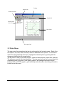
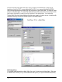
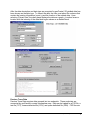
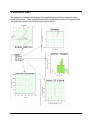
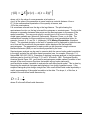
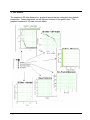
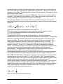
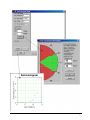
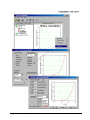
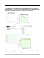
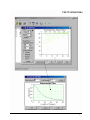
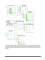
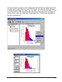
geoFractal: Geostatistical and Fractal Analysis for Spatial Data User Manual Version 1.0 September 2000 Prepared by: Paul LaPointe Anna Burago Kuantsai Lee Bill Dershowitz FracMan Technology Group ©Golder Associates Inc., 2000 geoFractal Manual.doc LICENSING geoFractal® was developed by Golder Associates Inc., Redmond, WA. Any permission granted for the use of this software includes the express condition that all liability and responsibility for the results obtained from use of this software is exclusively that of the individual user or organization. Golder Associates makes no warranty of the accuracy, functionality or application of this software. Users entire remedy shall be limited to refund of the purchase price. This software may not be incorporated into any commercial product without written authorization from the copyright holders. Information in this document is subject to change without notice and does not represent a commitment on the part of Golder Associates Inc. The software described in this document is furnished under a license agreement. The software may be used or copied only in accordance with the terms of the agreement. It is against the law to copy the software on any medium except as specifically allowed in the license agreement. No part of this document may be reproduced or transmitted in any form or by any means, electronic or mechanical, including photocopying, recording or information storage and retrieval systems, for any purpose other than the licensee’s personal use, without the express written permission of Golder Associates Inc. Copyrights for this software, techniques, and documentation are reserved by Golder Associates Inc., 2000. Table of Contents • i Table of Contents Licensing.............................................................................................................................................. i 1 Introduction to geoFractal.............................................................................................................. 1 1.1 Overview of Program Structure........................................................................................................... 1 2 Installing geoFractal....................................................................................................................... 2 2.1 What You Will Need.............................................................................................................................. 2 2.2 Installing and Initializing geoFractal................................................................................................... 2 2.3 Uninstalling geoFractal ......................................................................................................................... 2 3 The geoFractal User Interface ....................................................................................................... 3 3.1 Basic Layout........................................................................................................................................... 3 3.2 Main Menu ............................................................................................................................................. 4 3.3 Toolbar Options ..................................................................................................................................... 5 3.4 Opening Files.......................................................................................................................................... 6 3.5 Graphical Interface ............................................................................................................................. 11 3.6 Chart Options ...................................................................................................................................... 13 3.7 Editing Fit Data .................................................................................................................................. 17 4 Borehole Data................................................................................................................................ 18 5 2D Data .......................................................................................................................................... 22 6 2D Gridded Data............................................................................................................................ 27 7 Fracture Trace Data...................................................................................................................... 31 8 Gridding Data ................................................................................................................................ 41 Index ................................................................................................................................................. 43 Table of Contents • ii 1 Introduction to geoFractal Welcome to geoFractal! geoFractal is a tool to characterize fracture data in ways that it is typically acquired. Although it contains many sophisticated algorithms to evaluate the fractal properties of fractures, it also makes it possible to evaluate alternative models, including uncorrelated stochastic spatial and geostatistical processes. geoFractal has been designed to run efficiently on most modern computers operating under the Windows family of operating systems. Future releases will expand geoFractal to other widely used platforms. geoFractal’s intuitive user-interface makes it possible to interactively test the data and view the results. One of the benefits of the software is that, upon import of a data file, all of the analyses are automatically carried out using default parameters. The user can immediately view the results. 1.1 Overview of Program Structure The highest level of geoFractal focuses on the type of data. There are four data types currently supported. These are: 1. Irregularly-spaced one-dimensional data, such as is typical of image logs, core, or scanlines; 2. Irregularly-spaced point data on two-dimensional surfaces. This type of data might represent single values determined at non-systematic locations, such as wells. 3. Gridded data. This data represents some parameter value assigned to an area represented by a cell in a finite rectangular grid. Gridded data can be imported directly into geoFractal, or irregularly-spaced two-dimensional data can be converted into a grid according to various user-selected options. 4. Fracture trace data. These traces might represent interpretations of lineaments, outcrop mapping, or top-of-reservoir structure maps. For each one of these four fundamental data types, geoFractal performs a number of analyses to describe the population statistics and to assess how well alternative spatial models characterize the data. Population statistics are displayed on the screen and may be optionally saved in ASCII files. The populations themselves are characterized by statistical distributions, typically by frequency histograms and cumulative probability graphs. The data underlying the graphs and the graphs themselves may be exported into formats readily accessible to graphics or word-processing programs. There are three broad categories of spatial analyses that geoFractal carries out: 1. Uncorrelated (Poissonian) processes; 2. Fractal (box dimension, mass dimension, and self-affine dimension); and Error! No text of specified style in document. • 1 3. Second-order stationary geostatistical processes. Each type of analysis allows the user freedom to specify salient calculation parameters. Since default graphs are rarely of sufficient quality for report reproduction or publication, geoFractal contains many options for customizing the appearance of the graphical output. These options are both flexible and intuitive. This manual first explores options and operations common to all four analyses. These options are such things as graphical customization and file manipulation. Next the manual describes operations and procedures specific to each of the four data types. The final section contains thoughts on how to analyze spatial data, or to organize and complete a project involving spatial data analysis. Successful completion of such projects requires more than knowledge of geoFractal. 2 Installing geoFractal 2.1 What You Will Need geoFractal can be installed on any PC compatible computer which operates with Microsoft Windows (95, 98, 2000, and NT). 2.2 Installing and Initializing geoFractal Similar to many current programs, a simple step-by-step interface is used for installing geoFractal onto your system. TO INSTALL geoFractal: Insert the Installation CD into your computer and click the geoFractal Folder. Select the Setup.exe icon and follow the prompts to complete installation. TO START geoFractal: Click the Start button and locate the folder to where geoFractal was installed in the Start menu and click the geoFractal icon. OR From Explorer, open the geoFractal program folder and double-click the geoFractalWin.exe file. 2.3 Uninstalling geoFractal Should you wish to uninstall geoFractal, the steps for uninstalling are explained below. TO UNINSTALL geoFractal: Click the Start button and select Control Panel from the Settings menu. Double-click the Add/Remove Programs icon. 2 • Error! No text of specified style in document. From the list in the Add/Remove Programs window, select geoFractal and click OK. Follow any further directions should they appear. 3 The geoFractal User Interface 3.1 Basic Layout The main window for geoFractal contains a viewing window and a control window. The program is run through a series of commands found in popup menus and from the main menu and tool bar. The following display shows the various sections of the basic layout. Error! No text of specified style in document. • 3 Main Menu Toolbar Dataset Info Bar Graph Info Dataset Plane (Tree View) Chart Plane Workspace Info 3.2 Main Menu The main menu lists operations that can be performed by the fractal program. Each of the four options, File, Edit, View, and Help, results in additional menu options. To choose an option from the geoFractal main menu, highlight the desired option by pointing with the mouse and clicking the left mouse button. The file menu is used to open new projects, close and save projects, export files, and print. The edit menu controls the chart properties. The view menu moves the on screen layout to a separate screen, previous or next viewing options, and changes cumulative curves between CDF and CCDF graphs. geoFractal help and information about the geoFractal is located in the help menu. 4 • Error! No text of specified style in document. 3.3 Toolbar Options vie w iew to ne xt sv Sw i tc h Sw it ch to p rev i ou w in it c Di s p lay ch ar t in an ew Ed do ha w rt ta da me ar a it c ha rt p Vi e w ter s rt ha t hi sc nt Ed Sa ve f i le P ri Op en ad ata f il e The toolbar provides shortcuts to frequently used functions. All of these functions are also found within the main menu. The toolbar contains commands to open new files, save existing projects, print charts, edit parameters, view data, edit the chart, create a new window, and toggle between various chart type options. Error! No text of specified style in document. • 5 3.4 Opening Files geoFractal for Windows recognizes four types of data: borehole (one dimensional) data, two dimensional data that does not follow a regular, gridded structure, two dimensional data that is gridded, and fracture trace data. Files are opened by selecting Open under the file menu and then choosing a file that contains one of the four types of data. Once the file has been opened, the user must specify the data type before viewing the data. 6 • Error! No text of specified style in document. Borehole Data Borehole data requires two data fields, depth of borehole and related data. Data can be loaded as a text file (TXT), comma delimited file (CSV), or a space delimited file (PRN). The data description and data type are prompted by geoFractal after borehole data has been chosen as the data type. To extract the data, the user must select the columns that contain the depth and related data. Upon selecting “Extract Data” the chart plane displays the data as a graph, data label versus depth. 2D Data Error! No text of specified style in document. • 7 2D data requires three data fields, the x and y location and related data. Data can be loaded as a text file (TXT), comma delimited file (CSV), or a space delimited file (PRN). After the data description and data type are prompted by geoFractal after 2D data has been chosen as the data type. To extract the data, the user must select the columns that contain the location information (x and y) and the location of the related data. Upon selecting “Extract Data” the chart plane displays the data as a graph, y location versus x location with data label intensity shown as various shades at the data location. 2D Gridded Data 2D gridded data requires three data fields, the x and y location and related data. Data can be loaded as a text file (TXT), comma delimited file (CSV), or a space delimited file (PRN). 8 • Error! No text of specified style in document. After the data description and data type are prompted by geoFractal, 2D gridded data has been chosen as the data type. To extract the data, the user must select the columns that contain the location information (x and y) and the location of the related data. Upon selecting “Extract Data” the chart plane displays the data as a graph, y location versus x location with the intensity of the data label region shown as a shaded block. Fracture Trace Data Fracture Trace Data requires data grouped into two endpoints. These endpoints are connected by geoFractal to create a traceplane map. Data can be loaded as a F2D file, a text file (TXT), comma delimited file (CSV), and space delimited file (PRN). F2D files are Error! No text of specified style in document. • 9 created in FracWorks95 by sampling fracture sets with traceplanes to create fracture trace maps. The user is prompted to give the data a descriptive name and then enter the column numbers of the desired data. After the columns are reset, the data can be extracted to create a trace map on the Chart plane. 10 • Error! No text of specified style in document. 3.5 Graphical Interface When data is imported into geoFractal, all relevant analyses are carried out using default parameters. The User is presented with a standard tree structure, which can be expanded or collapsed. An example of the graphical interface for fracture trace data is shown below. Error! No text of specified style in document. • 11 12 • Error! No text of specified style in document. 3.6 Chart Options All graphical displays in geoFractal can be modified according to color, scale, labels, marker style, line style, grid line thickness and frequency. The following figures show all windows associated with chart parameters. There are nine tabs that define the options available to modify the layout: general, page, x-axis, y-axis, x-scale, y-scale, gridlines, line, and marker. The windows are displayed under the edit menu or as a popup menu in chart layout. Error! No text of specified style in document. • 13 Change the graph title, add or subtract a frame, change font, or change plot background Changes the page size and margins (not implemented in current version) Change the title of the axis, the location of the axis, and axis style or the font style 14 • Error! No text of specified style in document. Change the axis scaling and representation. The user can define the minimum and maximum values for the axis, the major and minor grid intervals, and whether and how the tick marks are displayed. Error! No text of specified style in document. • 15 Both major and minor grid lines can be displayed. The user can define the colors of these lines, their thickness, and their style. A line is often the result of a regression or similar calculation performed on the data. The user may change the line color, thickness or style. Markers are symbols denoting data points. The user can change marker color, size and style. 16 • Error! No text of specified style in document. 3.7 Editing Fit Data Under each edit parameter option, the user has the option to modify data points by omitting outliers. This is done by highlighting the data to be removed and right clicking the mouse to display the remove option. Data can be re-added by the same procedure. The process of adding and removing data effects the curve chosen to fit the data. All statistics are automatically adjusted to the resulting change. Error! No text of specified style in document. • 17 4 Borehole Data The analysis of borehole data displays four graphical layouts that are computed using default parameters. These parameters can later be adjusted to better fit the specific data. The graphical interface for borehole data is shown below. 18 • Error! No text of specified style in document. The first graphical interpretation of the data is represented as data type versus depth. The data points are connected to show the general trend of the data. The second graphic displays the cumulative density function (CDF) of the data as data type versus percentile. This graph can be easily altered to show a CCDF graph. This option as well as the option to change the scale (linear, log - linear, log - log, linear - log) is found in the toolbar. To fit a curve to the CDF or CCDF function the user must decide if the data is most accurately fit using a normal, log normal, power law, or exponential curve. Statistics are calculated for the user to access the fit. The third graphic displays a histogram of data type versus percent of total. Interval range and increment spacing can be changed under the edit parameter option in the popup menu. To fit a curve to the histogram, the user decides on the appropriate curve type and checks the statistics. The fourth graphic shows the CDF of spacing as data spacing versus the percentile. The graph can be displayed as a CDF or CCDF graph. A normal, log normal, power law, or exponential curve can be fit to the data. The final graph displayed for borehole data is the geostatistical analysis; this analysis describes the spatial correlation between observations in terms of a second order moment defined as: Error! No text of specified style in document. • 19 γ (h) = 12 E [( x( z ) − x( z + h)) 2 ] where x(z) is the value of some parameter at a location z x(z+h) is the value of the parameter at some location a vectorial distance h from z E[ ] is the mathematical expectation of the quantity in braces, and γ(h) is the semivariance. h is sometimes referred to as the lag or the lag distance. The plot showing the semivariance function vs. the lag is termed the variogram or semivariogram. The lag is the distance or separation between data points and the semivariogram is a measure of the spatial correlation. The user must specify a model type to fit a curve to the data. The model types available are: Spherical, Exponential, Gaussian, Power, or de Wijs. The mathematical formulae for these models can be found in most geostatistical texts, for example, Journel, A. G. and Ch. J. Huijbregts (1978) Mining Geostatistics (Academic Press). The standard deviation or the sum of squares error is displayed to guide the user as to how well the model with the parameter values displayed fits the empirical semivariogram. The parameters for each model can be computed using a minimum likelihood estimator (MLE) or can be directly specified by the user. Semivariogram analysis can be used to examine both the second order spatial correlation in the data, and also the self-affine fractal properties (see, for example, Burrough, P. A. Nature 294, 240-242 (1981)). Examples of applying variogram analysis to fracture pattern attributes can be found in La Pointe, P. R. and J. A Hudson, 1985. Geological Society America Special Paper 199. geoFractal’s semivariogram models makes it possible to test several of the most common functions that exhibit second order stationarity. geoFractal also makes it possible to evaluate the self-affine fractal model. This is done by computing the empirical variogram and displaying it on doubly-logarithmic axes. If the empirical variogram plots along a straight line, then a self-affine fractal model isprobably a useful representation of the spatial correlation in the data. The slope, θ, of this line, is related to the self-affine fractal dimension by: D = 2 − θ2 where D is the self-affine fractal dimension. 20 • Error! No text of specified style in document. The user can define the lag values in terms of the minimum lag, the maximum lag and the number of lags. The lag width is equal to (max lag – min lag)/number of lags. The default lag interval is arithmetic, but the user may wish to specify the lags as uniform in log space if the object is to test the self-affine fractal model. The semivariogram cloud model displays all of the raw lag pairs, rather than just the mean value for each lag class. Error! No text of specified style in document. • 21 5 2D Data The analysis of 2D data displays four graphical layouts that are computed using default parameters. These parameters can be adjusted to better fit the specific data. The graphical interface for 2D data is shown below. 22 • Error! No text of specified style in document. geoFractal displays 2D data as graphically as the x-location versus the y-location with the value of the data type displayed as a gradationally colored circle. Values for the data are assigned a color value. The grading color is shown at the top portion of the graph covering the full range of data values. The second graphics displays the data as a CDF graph. The data type is plotted against percentile. This graph can be modified to a CCDF graph and a curve of type normal, log normal, power law, or exponential curve can be fit to the data. The final graph displayed for borehole data is the geostatistical analysis; this analysis describes the spatial correlation between observations in terms of a second order moment defined as: [ r r r r 2 1 γ (h ) = 2 E ( x( z ) − x( z + h )) ] where x(z) is the value of some parameter at a location z x(z+h) is the value of the parameter at some location a vectorial distance h from z E[ ] is the mathematical expectation of the quantity in braces, and γ(h) is the semivariance. h is sometimes referred to as the lag or the lag distance. The plot showing the semivariance function vs. the lag is termed the variogram or semivariogram. The lag is the distance or separation between data points and the semivariogram is a measure of the spatial correlation. The user must specify a model type to fit a curve to the data. The model types available are: Spherical, Exponential, Gaussian, Power, or de Wijs. The mathematical formulae for these models canbe found in most geostatistical texts, for example, Journel, A. G. and Ch. J. Huijbregts (1978) Mining Geostatistics (Academic Press). The standard deviation or the sum of squares error is displayed to guide the user as to how well the model with the parameter values displayed fits the empirical semivariogram. The parameters for each model can be computed using a minimum likelihood estimator (MLE) or can be directly specified by the user. Semivariogram analysis can be used to examine both the second order spatial correlation in the data, and also the self-affine fractal properties (see, for example, Burrough, P. A. Nature 294, 240-242 (1981)). Examples of applying variogram analysis to fracture pattern attributes can be found in La Pointe, P. R. and J. A Hudson, 1985. Geological Society America Special Paper 199. geoFractal’s semivariogram models makes it possible to test several of the most common functions that exhibit second order stationarity. geoFractal also makes it possible to evaluate the self-affine fractal model. This is done by computing the empirical variogram and displaying it on doubly-logarithmic axes. If the empirical variogram plots along a straight line, then a self-affine fractal model isprobably a useful representation of the spatial correlation in the data. The slope, θ, of this line, is related to the self-affine fractal dimension by: D = 2 − θ2 where D is the self-affine fractal dimension. Error! No text of specified style in document. • 23 The calculation of the semivariogram for irregular 2D data requires the specification of several parameters. These include the minimum and maximum lags, the number of lags, and the mean direction and angular tolerance of the lags. Journel, A. G. and Ch. J. Huijbregts (1978) Mining Geostatistics (Academic Press) is a good reference for this calculation. geoFractal displays a menu that allows the user to specify the angle and shows the results in a graphical form for easy checking. The example shown below shows a direction specified as ±30° from east-west. Only data pairs that are within this green angular window will be included in the semivariogram calculation. 24 • Error! No text of specified style in document. Error! No text of specified style in document. • 25 26 • Error! No text of specified style in document. 6 2D Gridded Data The analysis of 2D gridded data displays five graphical layouts that are computed using default parameters. As with other data types, geoFractal allows the user to change these parameters. The graphical interface for 2D gridded data is shown below. geoFractal displays 2D gridded data as plot of the x-location versus the y-location. The data has been grouped into bins specified by the user as the amount of rows and amount Error! No text of specified style in document. • 27 of columns the data will be group into. The value of the data type within a unique bin displays as a color determined on a gradational color scale. The second analysis consists of a CDF graph, which plots the data type against percentile. The graph can be easily altered to show a CCDF graph. This option as well as the option to change the scale (linear, log - linear, log - log, linear - log) is found in the toolbar. To fit a curve to the CDF or CCDF function the user must decide if the data is most accurately fit using a normal, log normal, power law, or exponential curve. Statistics are calculated for the user to access the fit. The third graphic displays a histogram of data type versus percent of total. Interval range and increment spacing can be changed under the edit paramenters option in the popup menu. To fit a curve to the histogram, the user decides on the appropriate curve type and checks the statistics. Version 1.0 of geoFractal allows the user to calculate the power spectrum of the gridded data. For more information on the calculation and use of the power spectrum of 2D fracture data, see La Pointe, P. R. and C. C. Barton, 1995. Fractals in Petroleum Geology and Earth Processes. Plenum Press, Chapter 12. Essentially, the data is distributed in a selfaffine fractal manner in 2D is the power spectrum plots as a straight linen in doublylogarithmic axes. The exponent of this line is not the self-affine fractal dimension, but is related to it, as explained in the reference above. in the special case where the line is approximately horizontal, there is no spatial correlation in the data. Spectral analysis often benefits from detrending and filtering the data. A satisfactory discussion of these pre-processing stages is beyond the scope of the manual. Most texts on signal processing contain sufficient information on these issues to enable the casual analyst to utilize these options. 28 • Error! No text of specified style in document. Error! No text of specified style in document. • 29 The final graph displayed for borehole data is the geostatistical analysis; this analysis describes the spatial correlation between observations in terms of a second order moment defined as: [ r r 2 r r γ (h ) = 12 E ( x( z ) − x( z + h )) ] where x(z) is the value of some parameter at a location z x(z+h) is the value of the parameter at some location a vectorial distance h from z E[ ] is the mathematical expectation of the quantity in braces, and γ(h) is the semivariance. h is sometimes referred to as the lag or the lag distance. The plot showing the semivariance function vs. the lag is termed the variogram or semivariogram. The lag is the distance or separation between data points and the semivariogram is a measure of the spatial correlation. The user must specify a model type to fit a curve to the data. The model types available are: Spherical Exponential, Gaussian, Power, or de Wijs. The mathematical formulae for these models canbe found in most geostatistical texts, for example, Journel, A. G. and Ch. J. Huijbregts (1978) Mining Geostatistics (Academic Press). The standard deviation or the sum of squares error is displayed to guide the user as to how well the model with the parameter values displayed fits the empirical semivariogram. The parameters for each model can be computed using a minimum likelihood estimator (MLE) or can be directly specified by the user. Semivariogram analysis can be used to examine both the second order spatial correlation in the data, and also the self-affine fractal properties (see, for example, Burrough, P. A. Nature 294, 240-242 (1981)). Examples of applying variogram analysis to fracture pattern attributes can be found in La Pointe, P. R. and J. A Hudson, 1985. Geological Society America Special Paper 199. geoFractal’s semivariogram models makes it possible to test several of the most common functions that exhibit second order stationarity. geoFractal also makes it possible to evaluate the self-affine fractal model. This is done by computing the empirical variogram and displaying it on doubly-logarithmic axes. If the empirical variogram plots along a straight line, then a self-affine fractal model isprobably a useful representation of the spatial correlation in the data. The slope, θ, of this line, is related to the self-affine fractal dimension by: D = 2 − θ2 where D is the self-affine fractal dimension. The calculation of the semivariogram for irregular 2D data requires the specification of several parameters. These include the minimum and maximum lags, the number of lags, and the mean direction and angular tolerance of the lags. Journel, A. G. and Ch. J. Huijbregts (1978) Mining Geostatistics (Academic Press) is a good reference for this calculation. geoFractal displays a menu that allows the user to specify the angle and shows the results in a graphical form for easy checking. The example shown below shows a direction specified as ±30° from east-west. Only data pairs that are within this green angular window will be included in the semivariogram calculation. 30 • Error! No text of specified style in document. 7 Fracture Trace Data The analysis of fracture trace data displays seven graphical layouts that are computed using default parameters. As with other data types, geoFractal allows the user to change these parameters. The graphical interface fracture trace data is shown below. Error! No text of specified style in document. • 31 Fracture trace data is displayed as a trace map. The data is imported as paired endpoints, which are connected to show the length and orientation of the fracture along a plane. The first graphical display shows the map as referenced to the x-location and y-location of each endpoint. 32 • Error! No text of specified style in document. The second analysis consists of a CDF graph, which plots the data type against percentile. The graph can be easily altered to show a CCDF graph. This option as well as the option to change the scale (linear, log - linear, log - log, linear - log) is found in the toolbar. To fit a curve to the CDF or CCDF function the user must decide if the data is most accurately fit using a normal, log normal, power law, or exponential curve. Statistics are calculated for the user to access the fit. Error! No text of specified style in document. • 33 34 • Error! No text of specified style in document. The third graphic displays a histogram of data type versus percent of total. Interval range and increment spacing can be changed under the edit parameters option in the popup menu. To fit a curve to the histogram, the user decides on the appropriate curve type and checks the statistics. geoFractal next analyzes the fracture trace data to find the box fractal dimension. For a thorough discussion on calculating the fractal box dimension, see Barton, C. C. and P. R. La Pointe, 1995. Fractal in the Earth Sciences, Plenum Press, Chapter 8. The graph displays the box size versus a count of the fractures in doubly logarithmic axes. The Box fractal model may be a useful model for the spatial pattern of the traces if the points lie on a straight line. There are three methods used to count the fractures: fracture centers, whole fractures, and random points on fractures. The Fracture Centers option creates a set of fracture trace centerpoints and computes the Box dimension of this set. The Random Points option is very similar, except that one or more random points are selected along the trace. Both options are primarily useful for determining model generation parameters, for example, for a Discrete Fracture Network model. The Whole Fracture option calculates the minimum number of boxes to cover the whole fractures, as it is done in the reference in the preceding paragraph. This is probably the best option for comparing 1D and 2D scaling properties of fracture data sets, since the Box dimension of fracture intersection points in a 1D sample, like a borehole, should be exactly 1.0 less than the Box dimension of the trace pattern in 2D. The slope of the line is equal to the Box fractal dimension for all options. To calculate the Box dimension, the User must specify the geometry of the calculation grids. In essence, the grid begins at the smallest values of X and Y data, and extends to the maximum grid size, as shown in the figure. the minimum or starting grid size is also displayed in the lower left hand corner of the larger square, to visually indicate the two extreme grid sizes. The user also needs to specify the number of grid cell sizes in between these two extreme values. To restrict the calculation to a subregion of the data set, the user should define a local or global mask and apply it. Error! No text of specified style in document. • 35 36 • Error! No text of specified style in document. Error! No text of specified style in document. • 37 The fifth type of analysis performed on the fracture trace data is Mass Fractal Analysis. This analysis compares the distance from a specified origin on the studied region to the number of fracture centers found within the distance from the origin. The user has the option to modify the origin for this analysis and the interval range for the analysis of various radii. The calculation method depends on the method chosen to count fractures, four options exist: fracture centers, whole fractures, fracture intersections, and fracture density (P21). The graph is then fit to a linear function or to a power function. geoFractal displays the statistics to allow the user to make the best fit. The Mass Fractal dimension is computed by determining how much of some parameter is in a region of a particular size. One of the original uses of this dimension was to examine the spatial scaling of mass in the universe, in which planets, suns, etc. are essentially “points” with a scalar value of mass associated with them. The calculation started with Earth at the center, and looked at how much mass was contained in spheres of everincreasing radius. The same type of calculation is performed on the fracture data. Again, the user has options on whether the fracture center points, traces or other parameters are examined. geoFractal allows the user to specify a central starting point, and the radius of the inner and outer circles, as well as the number of circles between them. The results are plotted as the Log(mass) vs. Log(radius). If this plot is a straight line, then a mass fractal model may be a useful model for the data. An alternative to using a single circle center is the multiple centers option. The user is free to select the starting points for this calculation with a mouse, or to allow the program to select a user-specified number of random starting points. The calculation is carried out for the circles surrounding each point, and the results for all of these starting points is displayed.. See La Pointe, P. R. in C. C. Barton, C. C. and P. R. La Pointe, 1995. Fractals in Petroleum Geology and Earth Processes. Plenum Press, Chapter 3, for the estimation of the fractal dimension from multiple starting points. The Mass Fractal dimension probably is most useful for assessing the scaling properties of fracture intensity, and for fluid flow. If the intersection points option is selected, then the result is akin to a 2D lattice percolation problem, for which it is known that critical percolation occurs when the mass fractal dimension is approximately equal to 1.89. The sixth and seventh types of analysis for fracture trace data are the CDF for Beacher Analysis and the PDF for Beacher Analysis. The Baecher analysis focuses on whether the spatial pattern in 2D conforms to a spatial Poisson process. The hallmark of such a process is that there is no spatial correlation in the data (This can also be assessed through the semivariogram, which should be a horizontal line if the data has no spatial correlation, a horizontal power spectrum, a box dimension equal to 2.0, and a mass dimension equal to 2.0). geoFractal grids the fracture trace data, and estimates the mean data density as a function of grid cell size. Next, it creates a PDF and CDF for a Poisson process that has the same mean density for the same grid cell size, and compares it to the actual results. For the PDF, a Chi-Square test is performed to check the goodness-of-fit. For the CDF, a Kolmogorov-Smirnof test is carried out. Test statistics are reported for both tests. The statistics are somewhat sensitive to the grid cell size chosen. Grid cells that are too large or too small will produce useless results. 38 • Error! No text of specified style in document. Error! No text of specified style in document. • 39 40 • Error! No text of specified style in document. 8 Gridding Data Irregularly spaced data can be gridded by specifying the new grid size, the origin of the grid, and the amount of cells. The user should also specify if the grid value is an average, minimum, maximum, or count. When analyzing borebole or 2D data, the option to grid the data is found in the edit menu under view/edit data. Error! No text of specified style in document. • 41 Index 2D data.......................................... 8, 24, 25, 26, 32, 44 Irregularly-spaced point data ................................... 1 2D gridded data..................................................... 9, 29 Beacher Analysis ...................................................... 40 Borehole data .............................................................. 7 Irregularly-spaced one-dimensional data ................. 1 Box dimension ................................................ 2, 37, 40 CCDF ............................................ 4, 20, 21, 25, 30, 35 CDF 4, 20, 21, 25, 30, 35, 40 Changing parameters Edit parameter ........................................................ 18 Omitting outliers .................................................... 18 Chart parameters ....................................................... 14 Chi-Square test.......................................................... 41 Curve Fit Exponential .......................................... 21, 25, 30, 35 Log normal........................................... 21, 25, 30, 35 Normal ........................................... 20, 21, 25, 30, 35 Power law............................................. 21, 25, 30, 35 Detrending ................................................................ 30 Edit 4 Edit parameter........................................................... 21 File 4 Fractal dimension........................ 22, 25, 30, 32, 37, 40 Fracture intensity Fracture centers ................................................ 37, 40 Fracture density (P21)............................................ 40 Random points ....................................................... 37 Whole fractures ................................................ 37, 40 Fracture Trace Data............................................. 10, 33 Trace map......................................................... 11, 34 Gridding Data ........................................................... 44 Help 4 Histogram...................................................... 21, 30, 37 Installing ..................................................................... 2 Kolmogorov-Smirnof test ......................................... 41 Linear function ..........................................................40 Main menu...................................................................4 Main window...............................................................3 Mass dimension.....................................................2, 40 Mass Fractal Analysis ...............................................40 Mass Fractal dimension.............................................40 Spatial scaling.........................................................40 Minimum lag .............................................................23 Minimum likelihood estimator (MLE) ..........22, 25, 32 Model types de Wijs..............................................................22, 32 Exponential.......................................................22, 32 Gaussian ...........................................................22, 32 Power................................................................22, 32 Spherical...........................................................22, 32 Opening files ...............................................................6 Comma delimited file (CSV)......................7, 8, 9, 10 F2D files .................................................................10 Space delimited file (PRN).........................7, 8, 9, 10 Text file (TXT) ...........................................7, 8, 9, 10 PDF 40 Poisson process ...................................................40, 41 Poissonian....................................................................1 Power function ..........................................................40 Power spectrum ...................................................30, 40 Second order moment....................................21, 25, 32 Self-affine dimension ..................................................2 Self-affine fractal.........................22, 23, 25, 26, 30, 32 Semivariance .................................................22, 25, 32 Semivariogram ............................22, 23, 25, 26, 32, 40 Semivariogram analysis.................................22, 25, 32 Stationary geostatistical processes ..............................2 Toolbar ........................................................................5 Tree structure.............................................................11 Uninstalling .................................................................2 View ............................................................................4 Error! No text of specified style in document. • 43