1
Nomad SatViewer
Getting Started Guide
Tripod Data Systems
345 Avery Avenue
Corvallis, OR 97333
541-753-9322
www.tdsway.com
Tripod Data Systems Software License Agreement
IMPORTANT: BY INSTALLING AND USING THE SOFTWARE PROGRAM, YOU ARE AGREEING TO BE BOUND
BY THE TERMS AND CONDITIONS OF THE LICENSE AGREEMENT AND LIMITATIONS OF LIABILITY
("Agreement"). THIS AGREEMENT CONSTITUTES THE COMPLETE AGREEMENT BETWEEN YOU AND TRIPOD
DATA SYSTEMS, INC. ("Licensor"). CAREFULLY READ THE AGREEMENT AND IF YOU DO NOT AGREE WITH
THE TERMS, RETURN THE UNOPENED MEDIA PACKAGE AND THE ACCOMPANYING ITEMS (including written
materials and binders or other containers) TO THE PLACE WHERE YOU OBTAINED THEM.
LICENSE. LICENSOR grants to you a limited, non-exclusive license to (i) install and operate the copy of the computer
program contained in this package ("Program") on a single computer and (ii) make one archival copy of the Program for use
with the same computer. LICENSOR retains all rights to the Program not expressly granted in this Agreement.
OWNERSHIP OF PROGRAMS AND COPIES. This license is not a sale of the original Program or any copies. LICENSOR
retains the ownership of the Program and all subsequent copies of the Program made by you, regardless of the form in which
the copies may exist. The Program and accompanying manuals ("Documentation") are copyrighted works of authorship and
contain valuable trade secrets and confidential information proprietary to LICENSOR. You agree to exercise reasonable
efforts to protect LICENSOR'S proprietary interest in the Program and Documentation and maintain them in strict confidence.
USER RESTRICTIONS. You may physically transfer some Programs from one computer to another provided that the
Program is operated only on one computer. You agree not to translate, modify, adapt, disassemble, decompile, or reverse
engineer the Program, or create derivative works based on the Program or Documentation or any portions thereof.
TRANSFER. The Program is provided for use in your internal commercial business operations and must remain at all times
upon a single computer owned or leased by you. You may not rent, lease, sublicense, sell, assign, pledge, transfer or otherwise
dispose of the Program or Documentation, on a temporary or permanent basis, without the prior written consent of
LICENSOR.
TERMINATION. This License is effective until terminated. This License will terminate automatically without notice from
LICENSOR if you fail to comply with any provision of this License. Upon termination you must cease all use of the Program
and Documentation and return them, and any copies thereof, to LICENSOR.
GENERAL. This License shall be governed by and construed in accordance with the laws of the State of Oregon, United
States of America.
LIMITED WARRANTIES AND LIMITATION OF LIABILITY
LICENSOR MAKES NO WARRANTIES OR REPRESENTATIONS, EXPRESS OR IMPLIED, REGARDING THE
PROGRAM, MEDIA OR DOCUMENTATION AND HEREBY EXPRESSLY DISCLAIMS THE WARRANTIES OF
MERCHANTABILITY AND FITNESS FOR A PARTICULAR PURPOSE. LICENSOR does not warrant the Program will
meet your requirements or that its operations will be uninterrupted or error-free.
If LICENSOR determines that the particular item has been damaged by accident, abuse, misuse or misapplication, has been
modified without the written permission of LICENSOR, you accept full responsibility for the product. Statements or
representations which add to, extend or modify this license agreement are unauthorized by LICENSOR and should not be
relied upon by you.
LICENSOR or anyone involved in the creation or delivery of the Program or Documentation to you shall have no liability to
you or any third party for special, incidental, or consequential damages (including, but not limited to, loss of profits or savings,
downtime, damage to or replacement of equipment and property, or recovery or replacement of programs or data) arising from
claims based in warranty, contract, tort (including negligence), strict liability, or otherwise even if LICENSOR has been
advised of the possibility of such claim or damage. LICENSOR'S liability for direct damages shall not exceed the actual
amount paid for this copy of the Program.
Some states do not allow the exclusion or limitation of implied warranties or liability for incidental or consequential damages,
so the above limitations or exclusions may not apply to you.
You assume all responsibility for, and LICENSOR shall not be liable for, all action taken, decisions made, and advice given as
a result of your use of the Software.
U.S. GOVERNMENT RESTRICTED RIGHTS
If the Program is acquired for use by or on behalf of a unit or agency of the United States Government, the Program and
Documentation are provided with "Restricted Rights". Use, duplication, or disclosure by the Government is subject to
restrictions as set forth in subparagraph (c)(1)(ii) of the Rights in Technical Data and Computer Software clause at DFARS
252.227-7013, and to all other regulations, restrictions and limitations applicable to Government use of Commercial Software.
Contractor > manufacturer is Tripod Data Systems, Inc., 345 Southwest Avery Ave, Corvallis, Oregon, 97333, United States
of America.
Should you have questions concerning the License Agreement or the Limited Warranties and Limitation of Liability, please
contact in writing: Tripod Data Systems, Inc., 345 Southwest Avery Ave, Corvallis, Oregon, 97333, United States of America.
Nomad SatViewer
2
SatViewer
SatViewer™ is for use ONLY with a Nomad™ that has built-in GPS. External GPS
receivers, Bluetooth GPS receivers, GPS CF cards or other external GPS devices
(including other SiRF II or SiRF III GPS receivers) are not supported and may not work
correctly with SatViewer.
On your Nomad, tap Start / Settings / System / System Information / Wireless to see
if it has built-in GPS. If it does, COM2 is the dedicated hardware port for the built-in
GPS (COM1 is dedicated to the external 9-pin). Your Nomad GPS receiver is
compatible with applications that accept the NMEA position information using a default
setting of 9600 bps.
Quick Start: The following steps will allow you to quickly connect to the GPS with
default settings:
1. Start SatViewer by tapping Start / Programs / SatViewer.
2. Tap on the GPS tab.
3. Make sure the COM setting is set to COM2.
4. Tap Connect to GPS. The fields Lat, Lon, Spd, Az and Ht will all read ? until
SatViewer connects to the GPS and obtains a satellite fix. If you are attempting
to get a satellite fix for the first time, it may take several minutes and it is
recommended to position your Nomad unit outside with no overhead
obstructions.
5. Tap Sky. Lat and Lon will change to current latitude and longitude when a
satellite fix has been completed.
Welcome to SatViewer. Your on-board GPS receiver features a 20-channel SiRF III
GPS receiver. The typical expected accuracy for this GPS receiver is about five to
fifteen meters. It has the capability of receiving correction signals (Satellite-Based
Augmentation System, SBAS) which may improve the accuracy of the GPS. However,
these correction signals are not consistently available in all locations. The typical
expected accuracy of the GPS receiver with the correction signals is about four to ten
meters.
Your Nomad GPS receiver updates its position once every second. It may take several
minutes to start tracking the first time you try to use it because it needs time to update
its position and download current satellite information from the GPS satellites. This
process will occur faster in a location with open sky.
SatViewer provides a way to quickly start using the GPS functionality of the Nomad,
but it is not a stand-alone mapping, GIS or navigation program by itself. SatViewer is
useful for checking the GPS configuration and enabling advanced features of your
Nomad GPS receiver when these settings are not made available in other applications.
When changing any GPS settings or other settings, it is important to wait a few
moments after tapping on the desired option to allow time for your Nomad GPS
receiver to implement the requested change. SatViewer communicates with your
Nomad GPS receiver to compute your current position, speed, direction (azimuth) and
Nomad SatViewer
3
height. This information is displayed at the top of the screen along with other
information about the satellite signals. Speed and direction measurements are only
useful when your Nomad GPS receiver is in motion. Standing in one position with your
Nomad GPS receiver may result in inaccurate readings in direction and speed. If you
are not moving, direction is reported as ? and speed is reported as “0”. Height
calculations from a GPS receiver are typically not very accurate. Vertical accuracy is
about two to three times worse than the horizontal accuracy). Units of measurement are
only displayed in U.S. feet and heights are only displayed in height above mean sea
level (MSL).
The pages of the application are accessed by tapping the various tabs, which are laid out
in index card format. The information in each tab is described on the following pages.
Nomad SatViewer
4
Sky Tab
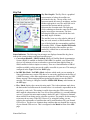
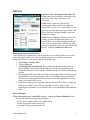
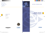
Sky Plot Graphic: The Sky Plot is a graphical
representation of where the satellites are
positioned in the sky. The top of the circle
represents north, the center is straight up, and the
farthest right point is east. The outer blue circle
represents the horizon and the red circle
represents the elevation mask. The light gray
circles radiating out from the center are the zenith
angles in ten degree increments. The lines
bisecting the light gray circles divide the circle
into thirty degree azimuths.
The satellite icons are color coded to indicate if
they are used, unused, or SBAS satellites. Each
icon is labeled with the corresponding satellite's
ID number (PRN). If Leave satellite SNR trails
is checked, the path of the satellites are also
marked by a dotted line as each satellite moves
across the sky.
Status Indicators: The following four messages are displayed around the sky plot to
indicate the current settings configured on other pages:
• Corrections Disabled / SBAS Enabled: displays if Satellite Based Augmentation
System (SBAS) is enabled or disabled. When SBAS is enabled, your Nomad GPS
receiver will attempt to locate, track and use correctional data supplied from an
SBAS satellite in order to improve accuracy. There are a limited number of SBAS
satellites available, so they may not be readily accessible in your area. This setting is
configured in the Type field on the DGPS page.
• In SiRF Bin. Mode / In NMEA Mode: indicates which mode you are running in.
Some applications may require GPS data to be sent to the application in the form of
a NMEA message, where other applications require the GPS data be sent as a SiRF
Binary message. Most mapping and navigation applications can use the NMEA
message. This setting is configured with the NMEA/SiRF Binary radio buttons on
the GPS page.
• Elev. Mask: displays the current elevation mask. This is the minimum angle above
the horizon that a satellite must be located before it is used and is represented on the
sky plot by a red circle. This setting is useful when using the GPS in areas where
there might be obstructions to the view of low flying satellites (e.g. around buildings
or trees). A typical elevation mask setting is between 5 and 15 degrees to eliminate
those satellites from being used to calculate a position. The purpose for this setting is
to increase the accuracy of the GPS. However, by using this setting, you are
reducing the total number of satellites that can be tracked and used by your Nomad
GPS receiver. The idea is to eliminate those satellites that may degrade the accuracy
of your Nomad GPS receiver. This is configured in the Masks section of the GPS
page.
Nomad SatViewer
5
• Masks: Displays the current PDOP and HDOP mask values as configured in the
Masks section of the GPS page. If the measured Dilution of Precision (DOP) value
exceeds the value set for the corresponding mask, the resulting calculated position
will be ignored. In general, as the value of the DOP decreases, the accuracy of the
GPS position increases. DOP values greater than six usually indicate the GPS
position data is of poor quality (due to poor satellite geometry) and the resulting
positions are less accurate. NOTE: DOPs can not be displayed in Binary Mode,
however, the DOP masks are still in effect.
Satellite Icons
• Unused: A GPS satellite whose signal is being received, but not being used for
position calculations.
• Used: A GPS satellite that is being used to calculate your current position.
• SBAS: A Satellite Based Augmentation System (SBAS) satellite, which can be used
for error corrections. (See the DGPS page for more information.)
Leave SNR trails: Creates a dot on the screen for all previous satellite positions that
form a trail on the sky plot over time as the satellite moves across the sky.
DOPs Bar Graph: displays the various Dilution of Precision (DOP) values as explained
below. DOPs are not displayed when SiRF Binary is selected on the GPS page.
• PDOP: displays the Position Dilution of Precision, which is a combination of
HDOP, VDOP and Time Dilution of Precision. It will always be larger than HDOP
and VDOP.
• HDOP: displays the Horizontal Dilution of Precision, which is a measure of the
calculated accuracy of the solution. DOP has no units and lower numbers indicate
better solution geometry. In general, the lower the DOP value, the better confidence
you have in the position reading from your Nomad GPS receiver.
• VDOP: displays the Vertical Dilution of Precision, which is a measure of the
calculated elevation.
Each DOP bar is color coded to indicate the DOP quality as follows:
Green: The DOP is less than three (best).
Yellow: The DOP is greater than three, but less than six.
Orange: The DOP is greater than or equal to six, but less than twenty.
Red: The DOP is greater than or equal to twenty (worst).
Signal vs. Satellite Bar Graph: shows all the visible satellites and their corresponding
ID numbers (PRN) ranging from 1 to 32. Also, the PRN for any currently tracked SBAS
satellite (ranging from 122 to 138) is displayed in this graph. Tapping any bar will also
display the signal to noise ratio (SNR) value for that satellite. The color of each bar
indicates the following:
Green: Good satellite signal strength. Satellite is used with an SNR greater
than or equal to thirty dB.
Yellow: Fair satellite signal strength. Satellite is used with an SNR less than
thirty dB.
Red: No signal or the signal strength is below the minimum allowable
threshold. Satellite is not used.
Nomad SatViewer
6
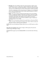
GPS Tab
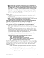
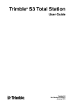
Connect to GPS / Disconnect from GPS: This
button either tries to establish a connection with
the GPS receiver chip or disconnects the
connection.
COM: used to select the COM port for
communication between SatViewer and your
Nomad GPS receiver. Your Nomad GPS receiver
port is set to COM2 and a baud rate of 9600. The
default SatViewer settings shouldn’t need to be
changed to connect.
NOTE: Before changing COM port or baud rate
settings, you must first disconnect from your
Nomad GPS receiver before making the changes.
After you have changed the COM settings, then
you can re-attempt to connect to your Nomad GPS
receiver, using the Connect to GPS button.
Enabling the Microsoft GPS driver
If you would like to connect two or more programs to your Nomad GPS receiver at the
same time (such as SatViewer and a navigation program) you will have to turn the
Microsoft GPS driver on by performing the following steps:
1. Tap Settings / System / GPS.
2. Tap the Access tab.
3. Tap Manage GPS automatically. This will turn on the Microsoft GPS driver.
Ensure that the GPS program port is COM3 (or any other port available in the
Microsoft GPS driver screen) and the GPS hardware port is COM2 with baud rate
of 9600.
4. The Microsoft GPS driver will now allow multiple applications to connect to your
Nomad GPS receiver at the same time. This can be helpful so that your Nomad
GPS receiver can be controlled with SatViewer while other applications are also
using your Nomad GPS receiver.
5. In SatViewer and any other program using your Nomad GPS receiver, change the
COM port to COM3 (or the COM port specified in Step 3 above). Both
applications will connect to your Nomad GPS receiver through the Microsoft GPS
driver.
Restore Defaults:
When connected to your Nomad GPS receiver: Tapping the Restore Defaults tab will
result in the following settings being changed:
• GPS receiver output will be set to NMEA mode
• Static Navigation will be turned OFF
• Smooth Tracking will be turned OFF
Nomad SatViewer
7
• Elevation mask is set to five
• PDOP mask is set to eight
• HDOP mask is set to eight
• GPS status voice prompt is turned OFF
• NMEA message settings under the Advanced page are changed as follows:
o GGA – 1 sec
o GSA – 1 sec
o GLL – off
o VTG – off
o GSV – 1 sec
o RMC – off
• DGPS settings under the DGPS tab are set back to their defaults of Usage: Auto,
Type: SBAS ON and SBAS Sat. PRN: Auto
• No change to any COM settings
Each of the above settings (except for the GPS status voice prompt) are sent and
applied to your Nomad GPS receiver.
When disconnected from your Nomad GPS receiver: Tapping the Restore Defaults tab
will result in the following settings:
• GPS receiver output will be set to NMEA mode
• Static Navigation will be turned OFF
• Smooth Tracking will be turned OFF
• Elevation mask is set to five
• PDOP mask is set to eight
• HDOP mask is set to eight
• GPS status voice prompt is turned OFF
• NMEA message settings under the Advanced page are changed as follows:
o GGA – 1 sec
o GSA – 1 sec
o GLL – off
o VTG – off
o GSV – 1 sec
o RMC – off
NMEA message settings (set to default or otherwise) will be sent to your Nomad
GPS receiver and applied the next time you connect to your Nomad GPS receiver
(with output set to NMEA).
• DGPS settings under the DGPS tab are set back to their defaults of Usage: Auto,
Type: SBAS ON and SBAS Sat. PRN: Auto
Since you are not connected to your Nomad GPS receiver, none of the above
changes are actually applied to your Nomad GPS receiver. To apply these
settings, you will need to first connect to your Nomad GPS receiver and then tap
on the Restore Defaults button.
• If the Microsoft GPS driver is not used, the COM port gets set to COM2.
Nomad SatViewer
8
• If the Microsoft GPS driver is used, the COM port gets changed to its assigned
program port.
• Baud rate is set to 9600
• Data bits are set to 8
• Flow is set to None
• Parity is set to None
• Stop bit is set to 1
To completely restore your Nomad GPS receiver back to the factory settings, perform
a system shut down on your Nomad for a minimum of five minutes before turning the
unit back on and attempting to reconnect with your Nomad GPS receiver in
SatViewer. In order to perform a system shut down, press down and hold the Power
button for a few seconds and then release. A Power Menu is displayed with different
options. Tap on the Shutdown button to put your Nomad into a system shutdown.
This procedure is beneficial when you are unable to connect your Nomad GPS
receiver to SatViewer due to a change in the communications settings caused by
another software application. In most cases, the factory reset procedure only needs to
be used when another application has changed the settings of the Nomad GPS
receiver and you would like to set them back to their original configuration.
NMEA / SiRF Binary: is where you choose to set your Nomad GPS receiver to NMEA
mode or SiRF Binary mode. When in SiRF Binary mode, DOP values are not available in
the Sky page. The mode you select here will also determine the format for the
information that can be viewed from the Data View page. Most GPS applications require
that your Nomad GPS receiver be set to output NMEA messages. There are some
specialized GPS applications which require the SiRF Binary output mode. Please consult
the documentation of your GPS application to see which output format you should use
and then choose that option via this setting.
Static Navigation: This feature keeps your Nomad GPS receiver from showing the
normal erratic positions when standing still. When checked, small changes in your
position are interpreted as GPS error and your computed position will remain unchanged.
For applications where you will be mapping or navigating at walking speed or slower, it
is recommended to disable this feature, so even small changes in position will be shown.
Smooth Tracking: This feature smooths the track generated by your Nomad GPS
receiver. When checked, movement is smoothed mathematically to reduce the seemingly
jagged movement resulting from GPS error. For unfiltered, raw GPS readings, you
should leave this box unchecked. However, if you want to see a smoother overall position
(e.g. while navigating), then turn this feature on via the checkbox.
NOTE: Both the Static Navigation and Smooth Tracking features modify your true
GPS positions mathematically so these features should not be used when you need the
most accurate GPS positions available.
Masks: These define limits that determine when a satellite will be used or not used.
Nomad SatViewer
9
• Elevation: This is the minimum angle above the horizon that a satellite must be
located before it is used. A value of zero would essentially turn off the elevation
mask. A value of ninety would mask all satellites. A typical elevation mask setting
is between five and fifteen degrees to block tracking of those satellites potentially
affected by multipath error due to obstructions (e.g. buildings or trees). Multipath
error is error to the GPS position from the satellite signal bouncing off of objects
before reaching the GPS receiver.
• PDOP: This is the maximum allowable Position Dilution of Precision (PDOP),
which is a combination of HDOP, VDOP and Time Dilution of Precision. While
exceeded, the GPS data will not be used for position calculations. This setting is
advantageous when quality and reliability of your position are of concern.
Typically, PDOP values of six or greater are considered “suspect” and therefore
resulting positions are less reliable.
• HDOP: This is the maximum allowable Horizontal Dilution of Precision (PDOP),
which is a measure of the geometrical quality of the solution. While exceeded, the
GPS data will not be used for position calculations.
NOTE: DOPs can not be displayed in Binary Mode, however, the DOP masks are still in
effect.
GPS status voice prompt: When checked, changes in GPS quality will result in an
audible message indicating the change.
Advanced: When tapped, opens the Advanced GPS screen described on the following
page.
Nomad SatViewer
10
Advanced GPS Page
Return to Default Settings:
When connected to your Nomad GPS receiver:
Tapping the Return to Default Settings button,
the following settings are changed and applied to
your Nomad GPS receiver:
•
Resets NMEA strings to defaults of:
o GGA – 1 sec
o GSA – 1 sec
o GLL – off
o VTG – off
o GSV – 1 sec
o RMC – off
NOTE: The COM settings are grayed out and
cannot be changed until you disconnect from
your Nomad GPS receiver.
When disconnected from your Nomad GPS receiver: Tapping the Return to
Default Settings button, the following settings are changed:
• Resets NMEA strings to defaults of:
o GGA – 1 sec
o GSA – 1 sec
o GLL – off
o VTG – off
o GSV – 1 sec
o RMC – off
NMEA message settings (set to default or otherwise) will be sent to your Nomad
GPS receiver and applied the next time you connect to your Nomad GPS receiver
(with output set to NMEA).
• If the Microsoft GPS driver is not used, the COM port gets set to COM2.
• If the Microsoft GPS driver is used, the COM port gets changed to its assigned
program port.
• Sets baud rate to 9600
• Data bits are set to 8
• Flow is set to None
• Parity is set to None
• Stop bit is set to 1
Since you are not connected to your Nomad GPS receiver, none of the changes
are actually applied to your Nomad GPS receiver.
Nomad SatViewer
11
COM: used to select the COM port for communication between SatViewer and your
Nomad GPS receiver. This field is also available on the GPS page for convenience and
changing it in one location will automatically change it in the other location.
Baud: sets the speed for communications between your Nomad GPS receiver and
SatViewer. The baud rate of your Nomad GPS receiver is 9600 by default. Please note, if
you have used another application to change the baud rate of your Nomad GPS receiver
to 4800 then it will take longer for your Nomad GPS receiver to respond to changes made
within SatViewer. During this period, you may see menu items grayed out while
SatViewer is sending the new settings to your Nomad GPS receiver.
Data Bits: should match the data bit rate set in the device you are communicating with.
Flow: should match the flow control set in the device you are communicating with.
Parity: should match the parity set in the device you are communicating with.
Stop bit: should match the stop bit set in the device you are communicating with.
NMEA Msg: This section allows you to control which NMEA messages are output by
your Nomad GPS receiver and the rate at which they are output. The GGA NMEA
message is automatically enabled by default and cannot be disabled. You may change the
frequency of output for the GGA NMEA message, but you may not disable it. Other
NMEA messages listed may be disabled as well as changing the frequency of output. The
ability to change the frequency of output and to disable certain messages is useful when
communicating at a very low baud rate to prioritize which NMEA messages are sent.
Each field allows you to select a value from one to five (measured in seconds), or to
select OFF. For example, selecting three instructs the receiver to output the
corresponding NMEA message once every three seconds. Selecting OFF instructs the
receiver to never output the corresponding message. This setting is only applicable when
you need to specify your Nomad GPS receiver to send out very specific NMEA messages
at specific times for your GPS application. Most users will not need to change this as the
default NMEA settings will work for most GPS applications trying to display common
GPS information (e.g. position, velocity, direction).
Nomad SatViewer
12
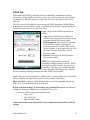
DGPS Tab
Differential GPS (DGPS) positioning involves subtracting a combination of ranges
measured to various satellites from two or more receivers measuring the same satellites
simultaneously. When the signals are subtracted, the major error sources cancel each
other out.
The GPS receiver used with SatViewer can provide DGPS through the Satellite Based
Augmentation System (SBAS), which uses multiple ground stations and then broadcasts
corrections to the end users via SBAS satellites.
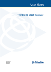
Usage: configures the DGPS requirements as
follows:
• Auto: will use DGPS when available, but
continue to provide autonomous (uncorrected)
positions when DGPS is not available.
• DGPS Required: will only provide positions
when DGPS is available. Autonomous
positions will not be available. When DGPS
data is available, it can be applied to your GPS
position to increase the accuracy of your
position reading.
• Ignored: will not provide DGPS positions
even when available.
NOTE: Due to the limited number and
availability of SBAS satellites in the sky, DGPS
coverage from SBAS satellites may not always
be available. Therefore, it is recommended that
you use the Auto setting where the GPS will use and apply DGPS data when available,
but will continue providing positions even when DGPS is not available.
Type: allows you to select SBAS ON or SBAS OFF. (Currently SBAS is the only DGPS
service available, but other DGPS systems may be available in the future.)
SBAS Sat. PRN: configures which SBAS satellite to use. Selecting Auto instructs the
GPS receiver to automatically make the selection.
Return to Default Settings: If connected to your Nomad GPS receiver, the following
settings are changed and applied to your Nomad GPS receiver:
• Restores DGPS settings back to default state:
o Usage: Auto
o Type: SBAS ON
o SBAS Sat PRN: Auto
If disconnected from your Nomad GPS receiver this button has no effect on DGPS
settings.
Nomad SatViewer
13
Data View Tab
The Data View page allows you to capture and view the GPS data being sent to
SatViewer by your Nomad GPS receiver over the COM port. There are two formats for
data that can be viewed from this screen depending on if you are running in NMEA or
SiRF Binary mode, as configured in the GPS page. This feature is useful if you have a
need to view or store the raw GPS messages as they come out from your Nomad GPS
receiver in a textual format. This feature is for advanced GPS users who need the ability
to store the raw GPS information as ASCII text in one large LOG file. This feature is
intended to collect up to several minutes of data. It is not intended for extended data
collection sessions.
When in NMEA mode, the data displayed is simply the raw NMEA codes being sent over
the COM port, which are displayed in their original ASCII format.
When in SiRF Binary mode, the data being sent over the COM port is in binary format
and therefore must be converted to ASCII text before it can be displayed in a useable
format. This involves converting each binary message to hexadecimal text and adding a
text tag to each message that explains what type of message it is.
Chars: Lists the number of characters captured
to the buffer. The maximum amount of characters
that can be stored to the buffer is approximately
64,000 characters. A “% full” indicator for the
used buffer is provided for your convenience.
Capture: Begins capturing the data passing over
the COM port and storing it to a buffer.
Stop: Stops capturing data and outputs the
contents of the buffer to the screen.
Clear: Clears the buffer and any data listed on
the screen.
View: Outputs the contents of the buffer to the
screen while capturing data.
Save: Opens a new screen where the contents of
the Data View screen can be saved to a file.
Nomad SatViewer
14
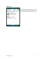
About Tab
The About page shows the SatViewer software
version as well as the SiRF III firmware version,
when connected to your Nomad GPS receiver.
Nomad SatViewer
15
Reference Materials
Nomad support (TDS):
E-mail: [email protected]
Web site: www.tdsway.com. Click on Support/Downloads and select Nomad.
Accessories:
You can expand the Nomad handheld computer’s capabilities by purchasing accessories.
Go to www.tdsway.com/products/nomad/accessories.
NOTICE for TDS European Union Customers
For product recycling instructions and more information, please go to:
www.tdsway.com/support/product_recycling
Recycling in Europe:
To recycle TDS or Trimble WEEE (Waste Electrical and Electronic Equipment products that run
on electrical power), call +31 497 53 24 30 and ask for the “WEEE Associate.”
Or
Mail a request for recycling instructions to:
Trimble Europe BV
c/o Menlo Worldwide Logistics
Meerheide 45
5521 DZ Eersel, NL
This product complies with international regulations for Restriction of Hazardous Substances
Directive (RoHS)
©2007 Tripod Data Systems, the TDS triangles logo, Nomad and SatViewer are trademarks of
Tripod Data Systems Inc., a wholly-owned subsidiary of Trimble Navigation Limited.
All other brand names and trademarks are property of their respective owners.
Display images shown may vary slightly from actual display. Data and specifications are subject
to change.
Rev. A 081807
Printed in the USA
Nomad SatViewer
16