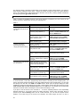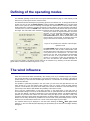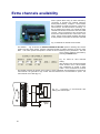
1
FCS-2 The Automatic Flight Control System User’s Manual Table of content Introduction ......................................................................................................................................................................... 1 Technical specifications..................................................................................................................................................... 2 Modes of operation ............................................................................................................................................................ 3 Automatic mode .......................................................................................................................................................... 3 Semiautomatic mode ................................................................................................................................................... 3 Inertial navigation mode (INS) ..................................................................................................................................... 3 Manual mode (RC) ...................................................................................................................................................... 3 Block diagram of the FCS-2 system .................................................................................................................................. 4 Autopilot connectors .......................................................................................................................................................... 5 Pin layout .................................................................................................................................................................... 5 Pin description ............................................................................................................................................................. 5 Installing the autopilot ........................................................................................................................................................ 6 BASE – the application for ground station........................................................................................................................ 7 Graphics in the BASE window ..................................................................................................................................... 8 BASE application menu ............................................................................................................................................... 9 Information and edit fields .......................................................................................................................................... 12 Setting up the system ....................................................................................................................................................... 13 The autopilot programming.............................................................................................................................................. 15 The AIRFRAME SETTING panel ............................................................................................................................... 15 Mission programming – the MISSION SETTING panel .............................................................................................. 21 Defining the flight route – the WAYPOINT SETTING panel........................................................................................ 23 Panel buttons ................................................................................................................................................... 23 The route edition in the text mode .................................................................................................................... 24 Graphical edition of the route without a map ..................................................................................................... 24 Graphical edition of the route using a map ....................................................................................................... 25 Defining the waypoints during the flight .............................................................................................................. 25 Preparing the maps………..………………………………………………………………………………..26 The final adjustments and control ................................................................................................................................... 26 Taking the photos ............................................................................................................................................................. 27 Programming the operating modes…………………………………………………………………………………………….28 The wind influence............................................................................................................................................................ 29 Additional functions ......................................................................................................................................................... 29 RPM measuring......................................................................................................................................................... 29 Analog input (AUX) .................................................................................................................................................... 30 Emergency procedures .................................................................................................................................................... 30 Calibration procedures ........................................................................................................................................................30 Gyro sensors calibration ...............................................................................................................................................31 Elevator position calibration ..........................................................................................................................................31 First flights ........................................................................................................................................................................ 31 Flight data ......................................................................................................................................................................... 33 Extra channels availability ............................................................................................................................................... 36 i ii Introduction The automatic flight control system FCS-2 (further it will be called autopilot) provides an automatic navigation and stabilisation of the flight of unmanned mini-aeroplanes on the predefined path. Both the small dimensions and the light weight of the device results from the usage of the newest and technologically advanced elements and parts. That is why the system can be used even in very small and light planes (about 2 kilograms). The FCS-2 autopilot has eight channels for controlling the same number of servos. Four or five of them are used by the flight control procedures and remaining can be used by the user to control additional operations, e.g., positioning the TV or still camera, opening a parachute, etc. The flight stability is provided by the three-axes set of gyro and acceleration sensors, pressure sensors used for measuring the altitude and the speed relative to the air. and two Navigation functions use data from the GPS receiver which is connected to the serial port of the autopilot. The second serial port of the autopilot is used for communication with the ground base station (it may be a notebook or PC). The communication with the control station uses either the cable or the radio link. The data exchange between the autopilot and the ground station is supported by the Windows application running on the base station. This application (BASE) also supports the definition of flight route in form of the geographic points set (up to 99 points), the flight altitude and speed, and a set of coefficients resulting from inertial features of the plane. Additional 150 waypoints can be defined by the user during the flight. Most of the predefined coefficients and flight parameters can be modified during the flight, providing the autopilot is equipped with a radiomodem. Due to the wireless communication, the current values of the velocity, altitude, position , course of the plane and other parameters are sent to the ground station once per second. The received data are processed by the ground station and then can be displayed in text or grafical form on the screen. Regardless of the radio modem usage, the flight data are always stored in the autopilot memory and they can be transferred to the computer after ending the flight. The application for the base station can be used for the so called mission programming as well. Such programming means the defining of positions of servomechanisms available for the user . The defined servomechanisms positions are set just after the particular waypoint of the route is reached. Optionally, the servomechanisms can return to their previous positions after one second delay. The FCS-2 autopilot cooperates with a manual remote control system (RC). This system enables taking over the plane control during the take off and landing phase. Optionally, the landing can be done automatically using the parachute. Manual control can be disabled by sending the special command via radiomodem. The very useful function of the autopilot is the continuous monitoring of control signals for servomechanisms used for flight control. The user can precisely trim the plane in manual control mode and then switch off the RC transmitter (control sticks of RC transmitter should be released before switching off). At this moment the autopilot stores the monitored signals as the neutral positions. The system software supports some emergency functions as well. For example, the decrease of the plane velocity below the user-defined threshold causes the system switches to the gliding flight and directs the plane towards the start point. If the plane is equipped with a parachute it can be opened when the altitude decreases to the user-defined value (i.e., 50 m). In this moment the plane engine is switched off as well. The FCS-2 autopilot requires powering by two separate batteries. One 5.8 to 8.5 V battery is used for the powering of the autopilot circuits, and the second (of 4.8 to 6 V voltage) is used for powering the GPS receiver, the RC receiver and the servomechanisms. Acceptable but not recommended is the use of a single battery. It is possible only when the special conditions are fulfilled. This will be explained further in this manual. Autopilot FCS-2 characterizes by low radiation level and therefore can be used without case with EMI shield. 1 Technical specification Dimensions (without case): 78 mm 46 mm 23 mm Weight (without case): 50 grams Supply voltages: 5.8 8.5 V / 120 mA (autopilot) 4.8 6 V (GPS and RC receivers , servos) Sensor used 3 gyro sensors of range 150 /sec. o 3 acceleration sensors of range 1.7 g. 2 pressure sensors measurements) (for altitude and velocity 3 temperature sensors (integrated with gyros). Number of channels: 8 (maximum 4 channels available for the user) Surfaces controlled Aileron, elevator, rudder , motor. Other surfaces can be controlled from channels 6 – 8. Plane types standard , delta , V-tail Digital input 1 (for RPM measurement) Analog input 1 (range 0 -2 V ) Serial ports 2 (for GPS and computer connecting) Data logging 27 parameters Data logging rate 1 Hz (some parameters are memorized at 2 Hz freq.) Telemetry update rate 1 Hz Gyro sensors sampling rate: 100 Hz Servo update rate: 50 Hz A/D converter resolution 11 bits Servo control time resolution 2,5 us Altitude measure resolution 0.1 m/bit Altitude calibration accuracy ± 5% Number of programmed waypoints: 100 (additionally 150 waypoints defined in flight) Servomechanism connectors standard: JR, Futaba or similar Operating system for the base station: Windows 98, Me, XP, 2000 , Vista ,W7 32 bits Maximum flight altitude: 0 - 3000 m (above sea level) GPS update rate 1 Hz Airspeed sensor range: 0 - 240 km/h Operation temperature range: -10ºC to +45ºC 2 The modes of operation Automatic mode This is the main mode of the autopilot operation. In such mode the plane flies according to the programmed path using the navigational data from GPS receiver. In the same time the operator can attend on other activity, i.e., the observation of images from the on-board camera. The operator can modify the flight path by the change of the current destination point (selected from the predefined set or newly created). The flight stabilisation function is accomplished by the autopilot as well. Semiautomatic mode In this mode the autopilot stabilises the plane flight only. Navigation function is performed by the operator who is obligated to define the flight course. The GPS system is used in the semiautomatic mode as well, but the predefined flight path is not valid. The plane flies holding the course until its change by the operator. The course data are sent using the radio link. This is very sensitive point because loosing the connection with the plane (i.e., when it goes out of the range) is dangerous. To avoid such situation, the base station sends automatically and periodically (with 20 s time interval) the command with the last defined flight course. When the autopilot does not receive this command twice, it switches to the automatic mode and directs the plane to the start point. When the radio communication is restored, the semiautomatic mode can be set again or the current destination point can be changed. Inertial navigation mode (INS) This mode uses the elements of inertial navigation system (INS). Generally, it is used when the GPS device sends invalid data to the autopilot. When the invalid GPS data are detected, the autopilot calculates the turning angle needed for the course towards the take off point using the last valid data. Then the system is switched to the INS mode and the turning is executed using the processed information from the gyro sensors. After the turning by the calculated angle the system keeps the plane in a straight flight. Flight stabilisation is the same as in other modes. If the switching to the INS mode is automatic then the autopilot returns to the automatic mode when the GPS data become valid. Take off point becomes the destination point. In this mode the wind is very important factor. The FCS-2 autopilot can seriously reduce the wind influence. The INS mode is used mainly in case of a troubles with GPS receiver, however it can be also used when the operator knows flight direction from sources other than GPS, e.g., from the on-board camera image, or direct observation of the plane. In such situation the operator can control flight direction sending the command with turn angle data. Manual mode (RC) In this mode the full control of the plane is executed by the operator. The mode starts when the transmitter for manual remote control (RC) is switched on. The suitable circuit in the autopilot detects this signal and then, if the signal is valid, disables the servomechanisms control signals generated by autopilot and enables the signals from RC receiver. The manual mode is used mainly in take off and landing phases. Manual control can be disabled by sending the command via radiomodem. 3 Block diagram of the FCS-2 system The FCS-2 system uses RCM3400 microprocessor module produced by Rabbit Semiconductor company. It contains the processor (29 MHz clock rate), RAM and FLASH memory, A/D converter and I/O ports. 11 bits, 8-channel A/D converter reads the output voltages from all sensors (gyroscopic, acceleration, pressure, temperature ) as well as the battery voltages. Block diagram of autopilot system is shown on figure 1. The parts inside the doted line are placed on autopilot board. The control mode detection unit should be discussed more exactly. The purpose of this circuit is to inform the processor when the manual control mode is switched on. It uses one channel of the RC receiver that is not involved in the plane control. When the width of control pulses in this channel is less than 1.5 ms or the pulses do not exist (i.e., the RC transmitter is switched off), the autopilot takes the plane control. The control mode detection circuit blocks autopilot control signals when the mode control pulses from RC transmitter become greater than 1.5 ms. RC receiver control signals are then used to control the plane. It is recommended that the channel used for control mode setting is served by a two-positional switch. The pulse width for the first position of this switch should not be greater than 1.1 ms and not less than 1.9 ms for the second position. GPS receiver can be mounted in different way. For non-cased autopilot GPS receiver is fixed to autopilot board just above the microprocessor module. For cased version it is mounted to the bottom side under the connecting pins. Both versions of autopilot allow connecting the GPS receiver by wire as a separate unit. PERIPHERAL CIRCUITS Figure 1. Block diagram of the FCS-2 system 4 Autopilot connectors Pin layout Layout of autopilot connectors is shown on Figure 2. The pins are numbered in columns (numbers 1 15 at the bottom) and in rows (number 1 - 4 on the left). The pin construction allows the use of light and reliable connectors for plugs manufactured by JR or FUTABA. The pins grouped with the dotted line on the figure are connected to each other. Static pressure sensor Dynamic pressure sensor 1 2 3 4 1 2 3 4 5 6 7 8 9 10 11 12 13 14 15 Figure 2. Connector pins layout (top view) Pins description Column 1 (BATT.1) Used to connect power to autopilot. Pins 1 and 4 are connected with common ground (GND) of autopilot. Pins 2 and 3 are connected together (only one of them may be used) and are the powering voltage terminals (+5.8 to +8.5 V). It is recommended that the plug for connecting the powering voltage should have four pins. Such plug protects the autopilot circuits against reverse voltage which can cause a failure. Column 2 (RPM) Pin 1 of this column is an input for RPM measure (see point ‘RPM measure’). Pin 2 is an analog input connected to A/D converter for measure of additional voltage. The range of measure is 0 +2 V (for more information see point ‘Analog input (AUX)’ in chapter ‘Additional functions’. Pin 4 is GND. Pin 3 supplies +5.2 V stabilised voltage to the circuit forming the pulses for RMP measure. Column 3 (BATT.2) Pins 4 and 3 of this column are connected respectively to negative (GND) and positive pole of the voltage source that powers the RC receiver, servomechanisms and GPS receiver. Pins 1 and 2 are used by the autopilot for measuring the value of this powering voltage. Powering of these devices can be done by different ways, for example by the battery that powers the autopilot itself. In such case the voltage regulator should be used to reduce the voltage to the level of 5 to 6 V. Then pins 1 and 2 are not used. 5 If the separate battery without voltage regulator is used for powering the devices then pins 1 and 2 should be connected together using the appropriate bridge. This bridge supplies the voltage from the pin 1 to the measuring circuit (pin 2). Columns 4 ... 11 (CH 8 OUT ... CH1 OUT) All three-pins columns are used for servomechanisms connections. All pins having the number 2 from columns 4 ... 11 are the outputs of channels 8 ... 1, respectively. Pins 3 and 4 are connected respectively to positive and negative pole of the voltage source that powers the servos. Column 12 (CH 5 IN ... CH8 IN) Pins 1 to 4 are the inputs of channels 5 to 8. These inputs should be connected to the outputs of channels 5 to 8 in the RC receiver (if they are used). Channel 5 input (pin 1) is used for switching autopilot control modes (automatic or manual). Column 13 (CH1 IN ... CH4 IN) Pins 1 to 4 are channel inputs for control the rudder , elevator , ailerons and throttle respectively. The inputs should be connected to the respective outputs of the RC receiver. Column 14 (GPS) Pins of this column are used for the GPS device connection. Pin 1 is Tx output and pin 2 is Rx input of the serial port1 in the microcomputer module. Pin 3 is the positive pole of voltage source that powers the GPS receiver (5 to 6 V). The same voltage source is used for both the GPS and RC receivers. Pin 4 is the common GND (identically as in columns 1 ... 11). Additionally, all pins of column 14 are connected to the sockets located on the bottom of the autopilot housing. (for cased version). Such sockets provide direct mounting of the GPS receiver on the autopilot. This column is also dedicated for supply and communication with extra channel servo controler (if used). Pin 1 must be connected to Rx line of serial port (see fig.20). Column 15 (COMP) This column is used for communication with the external computer ( base station). Pin 1 is Tx output and pin 2 is Rx input of the serial port 2 of the microcomputer module. They should be connected to the respective Rx and Tx lines of the radiomodem or base station. Low and high voltage levels of Tx and Rx lines of autopilot are 0 and 3.3 V. If the external computer is connected directly then the additional circuit for matching the voltage levels in the computer and the autopilot should be applied. This matching circuit (and the radiomodem if it is used) can be powered from pin 3 that is connected to +5.2 V. Pin 4 is connected to common ground of the autopilot. The current drawn by radiomodem in receive and transmission mode should not be greater than respectively 100 and 300 mA. Otherwise radiomodem should have it’s own power supply. NOTE: The cable link is required during programming the autopilot or retrieving the collected flight data. The radio link is used during the flight to transmit the commands and receive the data. To make such operation easier the two-section switch for switching between these communication links can be applied. It should switch the Tx line and +5.2 V voltage line powering the radiomodem and Tx/Rx voltage level matching circuit. Installing the autopilot The way of mounting of the autopilot in the plane is important for its proper operation. First of all, the three main axes of the plane (X, Y and Z) should be aligned with the respective axes of the gyro 6 sensors in the autopilot. It means the autopilot have to be mounted horizontally, accordingly with the flight direction and with connectors on the top and at the back(see Figure 3). AUTOPILOT Figure 3. The recommended mounting of the autopilot in the plane According to the Figure 3 the autopilot is located in the box that is rigidly mounted to the fuselage. The space between the autopilot housing and the box walls (hatched area on Figure 3) is filled with a foam rubber. The foam rubber prevents the autopilot against vibrations and minimises an influence of shocks during the landing. The recommended thickness of the foam layer is 6 to 10 mm. Autopilot non-cased can be mounted to the additional frame (for example 1.- 1.5 mm fibre glass or carbon composite) by means of the screws jutting at the bottom of the main board. This frame should be mounted to the fuselage flexibly for vibration reduction. The pressure measuring system should be installed as well. It is connected with two pressure sensors in the autopilot by means of silicon pipes of 2 mm inside and 4 mm outside diameter. One sensor measures dynamic pressure that is recalculated to the flight velocity relative to air. Another sensor indicate static pressure that is the measure of the flight altitude. Figure 4. The scheme of the pressure system installation The connections between pressure sensors and external pressure system consisting of Pitot pipe located inside an outer pipe of 9 to 10 mm diameter are shown on Figure 4. The outer pipe outlet is connected to the altitude sensor. The pipe has two rows of 10 holes of 1.2 mm in diameter (one row on the top and one on the bottom) in its front end. The Pitot pipe (the inner one) of about 3 mm in inner diameter is connected to the speed sensor. The pressure measuring pipe system should be aligned with the direction of flight. It is important that the system is mounted out of the range of the air stream generated by the propeller (for example on the wing). The Pitot pipe inlet should be placed about 10 to 15 cm in front of the wing attack edge to avoid the air turbulence caused by the plane. BASE – the application for ground station The FCS-2 system includes the BASE – application for base station computer. It can be either a desktop PC or a notebook with Windows operating systems specified in chapter ‘Technical specifications’ and with the serial port. If the computer has no serial port, the USB port with a special USB –RS232 converter can be used. Installation of the program can be performed in the standard way by running the setup.exe file. The BASE application can operate either with the geographical maps in form of bitmap files (*.bmp) or without any maps. The maps are not delivered on default. 7 The application is used for the autopilot programming before the flight and for communication with it during the flight if the system is equipped with a radiomodem link. After the flight the data stored in the autopilot memory can be send to the base station using the BASE application and then visualised in a text or graphic form. The main application window is shown on Figure 5. Figure 5. The general view of the BASE main window Graphics in the BASE window Within the main window of BASE application we can see three graphic fields. The largest field (named the central field in next chapters) is designated for the graphical programming and visualisation of the flight route, displaying the map (if it is optionally installed), and presenting the flight data in a text form. The graphs presented in this field can be moved horizontally and vertically by means of scroll bars placed on the upper and left side of the field. The drawing scale of flight route can be modified. When the scale used in the central field does not allow the details of the plane route to be accurately shown, the separate field is used. It is called the zoom field and is located above the left upper corner of the central field. The zoom field follows the plane and contains the zoomed drawing of the route. When the route line reaches the zoom field edge then the drawing process starts from the opposite edge. The scale used in the zoom field corresponds with the best resolution of central field and equals about 2 m/pixel. The real area on the Earth surface covered by the zoom field is about 410 m 280 m. The zoom field can be also used as the place for drawing the graph of flight speed (from the GPS) versus the flight course. Such graph is useful for establishing the speed and direction of the wind. The third graphics field in the main window is used for presentation of the current flight altitude versus time and that’s why it is called the altitude field. It is horizontally elongated and located above the central field. Vertical scale (on the altitude axis) is 1 m/pixel, and the horizontal one (on the time axis) is 1 s/pixel. The graph shows the altitude related to the one measured during the programing process.The field contains two blue horizontal lines. The solid line represents the ground level and the dashed one represents 50 m level. The graph can be scrolled in the field horizontally and vertically by 8 the scrollbars located at its bottom and left side, respectively. Additionally, the small text field located on the left of the horizontal scrollbar contains information about the time of automatic flight (in seconds) corresponding to the first visible pixel of the graph. Of course, the graphs in all fields are drawn only when the ground station receives the valid data “on the fly” using the radio link. If the radio link is not available then both the flight route and the flight altitude could be displayed after retrieving the data from the autopilot. It is possible after the landing (via cable only). BASE application menu All items of the BASE application main menu and its submenus are described below: Data Load flight data Loading flight data stored on the disk. After loading the flight route and the altitude vs. time graph are displayed in their graphics field. Save flight data Saving the data read from autopilot to the disk file. Recommended and default filename extension is .dta. Autopilot reading Retrieving data from the autopilot after the flight. Before this operation the autopilot and computer must be connected via cable (included). NOTE: The powering of the autopilot and RC Transmitter should not be switched off before sending the data. This menu function reads data only to the memory. Save flight data submenu is used to store data on the disk. Load airframe data Loading the plane-specific parameters from the disk. The loaded plane data are displayed on AIRFRAME SETTING panel that can be opened from Factors menu. The file containing plane parameters is one of the three autopilot programming files. The plane parameters are described in detail further in this manual Save airframe data Saving the parameters edited on AIRFRAME SETTING panel to the disk file. Load mission data Loading the mission defining parameters. This is the second file that programs the autopilot. The file contains altitudes to be reached in particular waypoints and the signals for user-available channels to be generated in these waypoints. The parachute recovery criteria can be also placed in the file. The file is created on the MISSION SETTING panel that is opened from Mission menu. Save mission data Saving the parameters created on MISSION SETTING panel to the disk file. Load waypoint data Loading the file with data defining the flight route. The data are geographical coordinates of points which are to be reached in flight. This is the third (and last) file required to program the autopilot. It is edited in graphic or text mode using the WAYPOINT SETTING panel. The way of creating this file will be described later. Save waypoint data Saves the flight route data created on the WAYPOINT SETTING panel to disk file. The panel can be opened from the Route > text edition menu. Read buffer Reads the recently written route data from the bufor.pnt file. This file is automatically saved on the disk at the moment when the data are sent to the autopilot using the SEND ALL button on the WAYPOINT SETTING panel. This is an emergency option that is useful when the data were not stored on the disk in other way and we have to read these data once again (for example when the computer hang off during the flight). The bufor.pnt file is located in the same directory as the BASE application. Route Text edition Displays the panel WAYPOINT SETTING for text edition of the flight route. Reset Deletes all edited waypoints. In such case the edition must be repeated from 9 the beginning (excluding the start point). Trace verification Corrects the invalid plane positions given by the GPS , if they were present. Start point Informs the program that we want to place the start point . Start point is created by the left mouse button click on the selected point of the central field. This point should be defined before the waypoints. Scale Opens the submenu that allows the central field scale selection. The scale values in the submenu are approximate, and the accurate values are displayed in the information field just above the left upper corner of the central field (when working without a map). The maps should contain it’s own scale. Factors Opens the AIRFRAME SETTING panel that allows the edition of the autopilot programming parameters (PID controllers and others) related to the aerodynamic and inertial features of the plane. Trim Active Enables the autopilot settings check mode. In this mode all components of the control surfaces deflections except those that are forced by gyros are equal to zero. In this way the neutral positions of control surfaces can be checked, as well as direction of control surfaces move forced by gyros. More details are given later in the manual. WARNING: This mode must be switched off before the flight. Inactive Text Data Disables settings check mode. Opens or closes the table with the flight data that are currently present in the application memory. The data can be vertically scrolled using a scrollbar on the left side of the table. Cursors Opens the Track fragmentation panel in the altitude field to highlight the selected fragment of the flight route and corresponding fragment of the altitude graph. The highlight is done after defining the first and last second of the interesting fragment and clicking O.K. button . Defined fragment of route becomes green. This function is very useful in flight data analysis. The geographical coordinates of the point corresponding to the start cursor will appear in Start cursor latitude and Start cursor longitude fields, respectively. The HIDE button closes the panel. Parameters Enables observation of the selected parameters. The selected parameter value is displayed in left field of the PARAMETERS panel that is located on the right side of the screen just above the altitude field. The content of the field is refreshed every second. The central and right field of the panel contain respectively the minimum and maximum value of the selected parameter measured from the moment of selecting. The list of all available parameters is given below: Calc. Course – the flight course calculated by the autopilot on the base of current position and coordinates of the point to be reached currently. Roll rotation – indicator of rolling speed (in bits). The value 0 means no rolling , negative and positive values mean the roll moving for right and left turn respectively. Roll gyro temperature –– temperature of roll gyro sensor in bits. 0 Change of 1 C = 4 bits. Roll gyro neutral pos. - – value (in bits) from roll gyro sensor recognized as neutral. It can be verified by calibration procedure. Pitch rotation – indicator of pitching speed (in bits). Negative and positive values mean the pitch moving down and up respectively. Pitch gyro temperature – temperature of pitch gyro sensor in bits. 0 Change of 1 C = 4 bits. 10 Pitch gyro neutral pos. –– value (in bits) from pitch gyro sensor recognized as neutral. It can be verified by calibration procedure. Yaw rotation – indicator of turning speed. The value 0 means straight flight, negative and positive values mean the left and right turn respectively. Yaw gyro temperature – temperature of the gyro sensor in bits. 0 Change of 1 C = 4 bits. Yaw gyro neutral pos. –– value (in bits) from yaw gyro sensor recognized as neutral. It can be verified by calibration procedure. Invalid GPS data – number of invalid GPS readouts from the beginning of current session (autonomous flight) . Roll – roll angle in degrees Pitch – pitch angle in degrees Acceleration sensor (X axis) – value (in bits) from X-axis accellerometer Acceleration sensor (Y axis) – value (in bits) from Y-axis accellerometer Altitude sensor indication –– value (in bits) from atmospheric preasure sensor. This parameter can have the values 50 – 2000 for every sub-range of altitude measure . Altitude range – sub-range of altitude measure. 7 and 0 mean the ranges for lowest and highest altitude respectively. Startpoint course – Expected course to the start point calculated after automatic switching the autopilot to the INS mode (due to invalid GPS data). Mission Mission setting Opens the MISSION SETTING panel that is used for mission programming. On this panel the target positions of user available servomechanisms (in CH5...CH8 channels) for the particular waypoints can be defined. The user can also set the altitude for each waypoint. Extra channels setting Opens EXTRA CHANNELS SETTING panel for setting the positions of servos connected to extra channels. These channels are available on external electronic panel (servocontroler) connected to autopilot via serial port Speed setting Opens SPEED SETTING panel for cruise speed defining RC blocade Submenu Active excludes possibility of manual (RC) control. Submenu Auto (1km) activates the function excluding possibility of manual (RC) control at distance plane – start point longer than 1 km. When this distance becomes smaller than 1 km this possibility is restored. Submenu Inactive restores possibility of manual control. Waypoints Point Displays the defined waypoints. Zone Displays the external boundaries around the defined waypoints. If the plane enters this area the autopilot assumes given waypoint as a reached. Map Load from file Opens the map loading dialog. The map covers the area of 10 minutes latitude by 15 minutes longitude. Auto loading Simplifies a map loading when the user does not know what map is valid for the given position of the start point. With this option the selecting of any .map file causes the proper choice on the base of current GPS data. This function should be used in the appropriate (third) phase of the autopilot programming. For using this option the maps should be specifically named. Delete map Removes the map from the program memory . Port Submenu COM1 … COM6 opens serial ports COM1 … COM6 respectively. The COM5 port is opened by default (if it’s possible) . 11 Demo Active This function draws the route and altitude of flight from data in RAM memory in real time. Inactive Disables the Demo function. Sound signal Active Enables the acoustic signalling when the data transmission from autopilot to base station breaks . Inactive Disables the acoustic signalling. Photo Opens the panel TRIGGER SETTING for photographic camera or other devices control programming. GPS/INS Opens the panel MODE SELECT for controlling the plane in semiautomatic or inertial (INS) modes. Wind Wind graph active Displays the panel for drawing the plane velocity vs. course graph. Wind graph inactive Closes the panel for drawing the plane velocity vs. course graph. Show data Draws the plane velocity vs. course graph from the read data. Course correction Opens the panel WIND INFLUENCE CORRECTION for correction of the plane course influenced by the wind (for INS mode). Calibration Gyro calibration Initiates calibration procedure (neutral position finding). Elev. calibration active Enables procedure of adjusting of neutral elevator position . Elev. calibration not active Disables procedure of adjusting of neutral elevator position . Information and edit fields Most of the information fields are placed just below the main menu bar. They display current information about the flight parameters (providing the radio link is used). The purpose of each information field is described below, starting from the left to the right side of the screen. Field title Field content description HOURS, MIN, SEK LATITUDE *) LONGITUDE Hours, minutes and seconds of the flight duration (in non- manual mode) . The latitude of the current plane position . *) The longitude of the current plane position . FIXED The fixed altitude of the flight in meters (relative to the start point level). CURRENT The current altitude of the flight in meters calculated from the atmospheric pressure sensor data (relative to the start point level). GPS The current altitude of the flight in meters (from the GPS data). COURSE The current course of the plane (from the GPS data). GND SPEED The current speed of plane relative to the Earth (from the GPS data). AIR SPEED The current speed of the plane relative to the air (calculated from the dynamic pressure sensor data). SAT. USED The number of the satellites being observed currently. 12 VALIDITY 1: GPS receiver data are valid, 0: GPS receiver data are invalid. PNT NO. Number of the current target waypoint. PARAM The current value of the parameter selected in the Parameters menu. PAR.MIN The minimum value of the selected parameter which appeared within the observation period (starting at the moment when the parameter is selected). PAR.MAX The maximum value of the selected parameter which appeared within the observation period (starting at the moment when the parameter is selected). *) In the programming phase the autopilot sends to the PC the information about its position (longitude and latitude). The transmitted coordinates are absolute, i.e., in the format used by GPS receiver. After programming the autopilot sends only the differences between current and start coordinates. Then absolute values of longitude and latitude are calculated in the BASE application from absolute start point position. If the application is restarted during the normal operation of the autopilot (for example when the computer hangs), then the programmed route must be read again. If the route was not stored on the disk, the Read buffer submenu should help. The remaining information fields and control elements are placed in vertical panel on the left side of the screen. The fields labelled APL and SERVOS display the voltage values that power the autopilot and servos respectively. Information field under the AUX button displays the voltage (in bits) existing at the analog input (column 2 , pin 2). This value is integrated in time and this integral can be visible after pressing AUX button. Then button change name to INT. Integrating is performed with the scaling factor A/D IN. COEFF. from AIRFRAME SETTING panel. The elements grouped under the name Altitude setting (m) are used for changing the flight altitude. The change happens after entering the data in the field and clicking the SEND button. The new altitude value is kept till the moment when the closest waypoint is reached. Then the altitude programmed for this point will be valid. Clicking the FIX button causes the autopilot keeps the current altitude until cancellation. The cancellation can be done by sending a new altitude value. The fields labelled Throttle and RPM, the SEND button and the slide bar placed just below them regards to the engine control. To change the throttle servo position chose the slider position and click SEND button. During the slider move the slider position is displayed in the Throttle field. The slider can set the servo position within the range defined in the AIRFRAME SETTING panel opened from the Factors menu. If the system includes the RPM measuring circuit, the RPM field shows the number of rotations per minute (see chapter ‘Additional functions’). The next three element groups labelled Aileron, Elevator and Rudder allow to set the positions of the airframe control surfaces i.e., the ailerons, elevator and the rudder. These elements are used during the first step of autopilot programming. The range of the control sliders change is between -49 to +49, what corresponds to pulse width 1 - 2 ms. The associated information field indicates the set value. The command for the correction of the selected surface position is sent after clicking the proper SEND button. The four information fields located under the label Neutral Position (THR. AIL. ELEV. and RUD.) indicate the current positions of the servos used to the flight control, i.e., counting from the left, the throttle, ailerons, elevator and rudder accordingly. The values appearing in these fields may vary in the ranges from 400 to 800, that corresponds with the control pulses width changing from 1 to 2 ms. Below these fields there is the Ch 5-8 Setting button that opens the panel containing the other fields and control elements. They have the same meaning as the elements from the groups: Aileron, Elevator or Rudder, but it serve the remaining four channels. The difference in setting the 5 to 8 channels and the flight control channels is that the user has the full setting range of pulse width (from 0.9 ms to 2.1 ms). The default settings in all channels equal to 128, that correspond with the pulse width 1.5 ms. Setting up the system Before using the FCS-2 system, you should connect all autopilot parts according to the Figure 6. Elements provided for the mounting in the airframe are placed in area marked with the dashed line. 13 RADIOMODEM (option) RADIOMODEM (option) RS PORT Tx COMP GPS CH1-4 IN CH5-8 IN CH-1 OUT +5V Rx Tx +5V GND 5.8-8.5V Unit generating the pulses for RPM measuring (Option) GPS, RC receivers and servos supply GND Rx Tx Tx GND GPS RECEIVER Servo CH 1-4 CH 5-8 - RADIOMODEM + SUPPLY Rx Signal level converter Rx GND Ch-8 OUT BATT.2 RPM AUX BATT.1 Autopilot and radiomodem supply RS PORT Rx Tx +5V GND Servo RC RECEIVER 4.8-6V Figure 6. The scheme of the connections between the FCS-2 system elements Due to the lack of place on the Figure 6, only two servos are shown. It is recommended to connect the servos to all channels, which are to be used. If the autopilot operates with the radiomodem, it is necessary to use 3-section switches labelled P1 and P4, which connect the autopilot to the computer via cable or radio link. As P1 switch, it may be used 2-section switch, but in this case the Tx lines of radiomodem and level matching circuit as well as powering lines (+5V) should be switched. The P4 switch can be omitted as well, provided the radiomodem is connected to the other serial port and the powering is set in the permanent way. In such case, while switching to the radio communication mode, you should select the suitable port using the option from the Port menu. The P1, P2, P3 switches and the Z1 socket should be placed in the wall of the plane’s fuselage. The communication between the computer and the autopilot uses the serial port. If the computer is not equipped in such port (currently manufactured notebooks usually do not have ones), you can use the USB port and the special USB-RS232 converter. After connecting the converter, you have to check what port number it emulates (e.g. using the Windows Device Manager). If you know the port number, you can open the BASE application and using the option of the Port menu, you can select the proper port from COM1 to COM6. As a default port COM5 is chosen (and the opened if possible) (provided that the USB-RS232 adapter is connected to the computer before running the BASE program). Ttransmission rate is set to 9600 bps. To power all system elements it is recommended to use two separate batteries, however you can use one battery with the bigger capacity for this purpose. Before powering on, you should be sure if the temporarily bigger power consumption caused by the servos movement doesn’t cause the battery voltage decrease below the value recommended for the autopilot, i. e., 5.8 V. The voltage drop below this value may cause wrong work or reseting the autopilot. NOTE: The highest supply voltage for autopilot is 8.5 V and mustn’t be exceed. When RC receiver is supplied from 6 V battery oscilation of servos can be observed after switching on and off the RC transmitter. In this case the RC receiver channel outputs and autopilot channel inputs should be connected via 1- 2.2 K resistors for reduction of pulses amplitude. Signal amplitude at autopilot channel inputs should not be greater than 4 V. These inputs (all pins of columns 12 and 13) are connected to the ground via 5.1 K resistors. If all elements of the system are connected, you set the P1 and P4 switches to the lower positions (the base station and autopilot are then connected by cable) and switch the power on, using the P2 and P3 switches. If everything is OK, after 2-3 seconds the autopilot sets the servos in the default middle positions and starts the dialog with the base station, i.e., it sends the information that it is ready for the programming. If the information is received by the base station, the AIRFRAME SETTING panel is opened . At this moment you can check the work of the gyro stabilisation. Turning the autopilot around the one of its three maim axes (longitudinal, transversal or vertical) you should notice the motion of the 14 proper servomechanism. You can now temporarily switch off the two power sources and make the steps described in the next chapter of this manual. The autopilot programming The AIRFRAME SETTING panel The AIRFRAME SETTING panel ( Figure 7) is used for the programming the different factors related to the inertial and aerodynamic features of the controlled airframe. The first setting, which has to be done, is the choice of its configuration using the options labelled AIRFRAME CONFIGURATION. The autopilot is dedicated for the three airframe types: normal, delta and V -tail. Figure 7. The airframe parameters setting panel Table 2 contains the description and the value ranges of all parameters set in the edit fields of this panel. The SEND buttons near some fields are used for sending to the autopilot the commands modifying given parameter during the flight or programming. NOTE: The values set in the ELEVATOR UP, ELEVATOR DOWN, ELEV.VS ROT. and ELEV. VS AIL fields must have the same sign. As the default values there are set the typical values excluding min.horiz.speed factor values. They do not take into consideration the “minus” signs preceding the numbers which reverse the motion of the servomechanisms. 15 Table 2 Field name Parameter description Range AILERON Proportionality coefficient for the aileron deflection. -99 to 99 ELEVATOR UP Proportionality coefficient for the up deflection of the elevator. -99 to 99 ELEVATOR DOWN Proportionality coefficient for the down deflection of the elevator. -99 to 99 RUDDER Proportionality coefficient for the rudder deflection. -99 to 99 THROTTLE min Sets the lower limit for the width of pulses that control the engine servomechanism. 0 to 99 (1 to1.4 ms) THROTTLE max Sets the upper limit for the width of pulses that control the engine servomechanism. 150 to 255 (1.6 to 2 ms) ELEV. VS ROT. The coupling coefficient for the deflection of the elevator vs. the roll. -99 to 99 A/D IN. COEFF. Scaling factor for integration the voltage at the analog input AUX (see chapter ‘Additional functions’). AIL. GYRO The gain coefficient for the roll gyro system -99 to 99 ELEV. GYRO The gain coefficient for the pitch gyro system -99 to 99 RUDD. GYRO The gain coefficient for the yaw gyro system -99 to 99 V1…V5 and N1… N5 Data defining the characteristics of neutral position of elevator versus air speed . 1 – 255 for V1-V5 472 -727 for N1- N5 Point number (1- 5) The digit indicating the defined point of chracteristics above. 1 to 5 RISE SPEED The rise speed in m/s (while reaching the set altitude) FALL SPEED The falling speed in m/s (while reaching the set altitude) SAIL SPEED The falling speed in m/s during the gliding flight (when the engine is switched off, i.e. in emergency situation). MIN. HORIZ. SPEED The minimum value of speed vs. the air in m/s that causes the switching to the emergency mode (i.e., switching to the gliding flight). For the last four parameters presented in the table the range is not indicated. The setting of proper values of these parameters requires from the user some knowledge about the aerodynamic features of the plane. These parameters must have the positive values, written with the accuracy of 1 decimal place. These values should be defined carefully for proper plane behaviour during the rising and falling and for the action of emergency procedure. NOTE: decimal places should be separated by dot point. The more precise description is necessary in the case of the V1… V5 and N1…N5 parameters. It is known that the plane trimmed for the given speed will be rising at the greater speed and will be falling when the speed decreases. To eliminate this effect it is necessary to correct the neutral position of the elevator. Therefore the neutral elevator position as a function of the air speed should be defined and V1…V5 and N1…N5 create this 5 point characteristics. N1…N5 are the numbers defining neutral elevator positions adjusted for the air speed V1…V5 respectively. The relation V1<V2 <V3 <V4 <V5 have to be fulfilled. Neutral positions for speed other than V1, V2, V3, V4 V5 are calculated from curve slope between the nearest points (fig. 8). V1 and V5 should be defined close to minimum and maximum horizontal speed of the plane respectively. V1…V5 and N1…N5 data can be determinened during the manualy controled flight. The use of radiomodem link is strongly recommended to do it. 16 During the fly after adjusting the neutral elevator position for selected speed (regulated by RPM) the speed can be read from AIR SPEED information field as well as elevator position from ELEV. field. To write this readouts as a suitable point of N vs. V characteristics you should define number of this point in Point number field and press the button SEND on the right of this field. NOTE: Before pressing SEND button the elevator stick of transmitter have to be released. After this operation the fields V and N corresponding to the digit in Point number field will fill in. If radiomodem link is not used the points of N vs. V characteristics should be writen to the autopilot memory by switching the autopilot to automatic mode (switching off the transmitter) for the 2-3 seconds. After restoring the manual mode and landing the memorized data should be send to the base station computer. Interesting data elev.n (elevator neutral position) and Vfix (air speed) should be visible after opening the text data table just under the line with parameter’s names (see chapter ‘Flight data’). Of course defining of every V ,N pair needs separate flight. If the plane propulsion is not electrical the defining of the V ,N pairs should be carried out at obout half tank of fuel. N When the speed and altitude is not changed during the flight (for example at first flights) defining of N vs. V characteristics is not essential and has not to be defined. In this case the option not valid should be marked. Otherwise all V,N pairs should be correctly defined . After every swithing Figure 8. Example of relation between the air speed and neutral elevator position. the autopilot from manual to automatic mode the current neutral position of elevator will be equal to measured one at last moment of manual mode. It is illustrated on figure 8. The 5 defined points represent N vs. V curve. Assume that after changing from manual to automatic mode autopilot detects the air speed and neutral elevator position corresponding to point A . Correction of neutral elevator position can be carried out accord the defined curve (solid line) or the dotted line passing through point A. In first case option valid ( fixed ) must be marked. Second case will be executed for option valid ( float ) chosen . The user can test both options and choose the one giving the better altitude stabilization. If air speed of plane is less then V1, correction is done with curve slope existing between points V1 and V2. For the speed greater than V5 the curve slope is 0. If option not valid is chosen the neutral elevator position corresponding to point A is fixed for all speed range. V There are eight checkboxes on the AIRFRAME SETTING panel. These checkboxes should be set respectively for the Delta and V-tail airframe types (except the rev. checkbox). The checkbox labelled 2 servos aileron control should be marked when each aileron is powered by the separate servo and the each one is controlled by the separate channel. The additional channel which should be used for the aileron control is channel 6. In such case, this channel cannot be used for any other purposes and these two servomechanisms must be mounted symmetrically to the longitudinal airframe axis, because the signal in the channel 6 is the same as in the channel 2. If there are no contraindications, i.e., using the ailerons as flaps (flaperons) in manual mode, it is recommended to control both servos from one channel (channel 2). Then it is necessary to use the Y type cable. In this case 2 servos aileron control checkbox should remain unmarked. The rev. checkbox from the THROTTLE group enables the change of the engine servo moving direction. If the checkbox remains unmarked, the value set in its left side defines position for the minimum rotations (or the engine switching off position). The value in the right field defines then the position of the throttle for the maximum RPM. Marking the rev. checkbox reverses the situation. Figure 9. The assignment of the control surfaces to the particular autopilot channels in the delta type airframe The three checkboxes labelled slave servo inv located vertically on the left side of the panel are used for the setting the direction of the slave servos. The slave servo (or slave channel) term has only 17 meaning in the case of programming of the “delta” or “V-tail” airframe types. In “Delta” system you have 2 slave channels. This is shown on the Figure 9. In this case, the servo driving the left aileron is connected to the channel 2, and the right aileron – to the channel 3. While forcing the motion around the airframe longitudinal axis (X), the main channel is channel 2, and the slave channel is channel 3. While forcing the motion around the crosswise axis (Y) the situation is reversed. The motion directions of main servos are set in the appropriate fields by setting (or not) the ( - ) sign which precedes the number. The motion directions for the slave servos are set by checking (or not) the appropriate checkboxes. The similar situation appears for the type V-tail system. The servo powering the left rudder is connected to the channel 4 (the main channel for the motion around the vertical axis), and the right – to the channel 2, which is (like in the previously described situation) the main channel for the motion around the Y axis. Below, in the chronological order there are given the actions needed for setting the servos move directions. These operations should be executed after the mounting the servos in the airframe and connecting them to the proper autopilot channels and control surfaces. NOTE: In the next steps it is assumed that for the V-tail airframe type the channel 4 controls the left rudder, and for the delta type airframe the channel 2 controls the left aileron. 1. Switch on the powering of the autopilot and the RC receiver. After 2-3 seconds the AIRFRAME SETTING panel should appear and the servos should be set in their default neutral positions. 2. If the airframe type is different than the normal one, you should choose the proper option and click the SEND CHECKBOXES SETTINGS button. 3. Move the Aileron slider (beyond the panel, on the left side of the screen) to the right position and click the SEND button (it is located just above the slider). The message about the change of the ailerons position should appear. 4. If the left aileron has moved down (for the right turn), the value in the AILERON field on the AIRFRAME SETTING panel should remain without changes (positive). In case of the up motion, you should write the minus sign preceding the number and click the SEND button near the field. The message about new value of aileron position should appear, and the left aileron should deflect to the opposite side as before. 5. Move the Elevator slider (beyond the panel, on the left side of the screen) to the right (up) position and click the SEND button just above the slider. The message about the change of elevator position should appear. 6. If the elevator (or right aileron for delta type) controlled by the channel 3 has deflected up, the value in the ELEVATOR UP , ELEVATOR DN and ELEV.VS ROT. fields on the AIRFRAME SETTING panel should remain positive. When the down deflection happens, you should change the value to the negative one and click the SEND button near the field. The message about new value of the elevator position should appear and the elevator deflection should have the contrary direction to the previous one. 7. Move the Rudder slider (beyond the panel, on the left side of the screen) to the right position and click the SEND button (located just above the slider). The message about the change of the neutral position for the direction rudder should appear. 8. If the rudder controlled by channel 4 has moved to the right (or up for the V-tail airframe type), the value in the RUDDER field on the AIRFRAME SETTING panel should remain positive. In the case of the left deflection, you should change the value to the negative and click the SEND button located near the field. The message about new rudder position should appear and the rudder should deflect in the correct direction. 9. Move the aileron slider to the neutral position and click the suitable SEND button. Repeat this operation for elevator and rudder . The actions described in steps 10 to 17 concern the “Delta” airframe type. 10. Move the Aileron slider to the left and send the new position to the autopilot by clicking the SEND button, simultaneously observing the motion of the right aileron (channel 3). 18 11. If the right aileron has deflected up, you should mark the checkbox close to the AILERON label (on the left) and click the SEND CHECKBOX SETTINGS button. 12. If the action from step 11 has been already executed, you should move the Aileron slider to the right and click the SEND button. The right aileron should deflect up. 13. Set aileron channel (2) in neutral position using Aileron slider and SEND button. 14. Move the Elevator slider to the left and send the new position clicking the SEND button, simultaneously observing the motion of the left aileron (channel 2). 15. If the left aileron deflected up, you should mark the checkbox near the ELEVATOR UP label (on the left) and click the SEND CHECKBOXES SETTINGS button. 16. If the action from step 15 has been already executed, you should move the Elevator slider to the right and click the SEND button. The left aileron should deflect up. 17. Set elevator channel (3) in neutral position using suitable slider and SEND button. The actions described in the step 18 -25 regard the “V-tail” system: 18. Move the Rudder slider to the left and send the new position clicking the SEND button. Observe the right rudder motion (channel 3). 19. If the right rudder has deflected down, you should mark the checkbox near the RUDDER label (on the left ) and click the SEND CHECKBOXES SETTINGS button. 20. If the action from step 19 has been executed, you should move the Rudder slider to the right and click the SEND button. The right rudder should deflect down. 21. Set rudder channel (4) in neutral position using suitable slider and SEND button. 22. Move the Elevator slider to the left and send the new position clicking the SEND button. Observe the left rudder motion (channel 4). 23. If the left rudder has deflected up, you should mark the checkbox near the ELEVATOR UP label and click the SEND CHECKBOXES SETTINGS button. 24. If the action from step 23 has been executed, you should move the Elevator slider to the right and click the SEND button. The left rudder should deflect up. 25. Set elevator channel (3) in neutral position using suitable slider and SEND button. 26. Move the Throttle slider to the right and click the SEND button located just above the slider. The engine servo should change the throttle position to increase rotations. If the action is opposite, you should mark the rev. checkbox and click the SEND CHECKBOXES SETTINGS button. 27. Match the utmost position for the maximum rotations, entering the proper number to the MAX window (near rev. checkbox ) and click the appropriate SEND button. 28. Check the chosen position, setting the Throttle slider at the utmost right position, and click the SEND button located just above the slider. 29. If the position is incorrect, repeat the actions from steps 27 and 28 for the different value written into the MAX field. 30. Match the utmost position for the minimum rotations, entering the proper number to the MIN window (near the rev. checkbox ) and click the proper SEND button. 31. Check the chosen position setting the Throttle slider at the utmost left position and clicking the SEND button located just above the slider. 32. If the position is incorrect, repeat the actions from steps 30 and 31 for the different value written into the MIN field. For the first flights it is recommended to leave the default absolute values of all factors defining the control surfaces deflections. The appropriate changes should be implemented in the accordance to the plane behaviour during the flight (this will be described later on). In this phase of the programming you should also set the values in the three edit fields, grouped under the name GYRO GAIN (and if it’s needed three checkboxes associated with them). 19 The absolute values in the fields corresponding to the particular control surfaces define gyro gains for these surfaces. Adding the minus sign ( - ) before the number changes the main servo move direction around the respective axis. Slave servos motion directions can be set by marking suitable checkboxes from the group named gyro slave servo inv. NOTE: The motion directions for main servos must be set first. Table 3 contains the possible reactions of the control surfaces (controlled by the main servos) for the rotation around the selected axis and ways of changing them. Table 3 Motion mode Control surfaces reaction Action to be done Rotation around the longitudinal axis (X) for the left turn The left aileron connected to channel 2 (main) deflects down. AIL. GYRO field should remain unchanged. The left aileron connected to channel 2 (main) deflects up. Enter the minus sign before the number in the AIL. GYRO field and click the SEND button. The right aileron connected to channel 3(slave) deflects down (“Delta” airframe type). Mark the checkbox near AIL. GYRO. label and click the SEND CHECKBOXES SETTINGS button. The right aileron (slave) deflects up The checkbox near AIL. GYRO (“Delta” airframe type). label should remain unchanged. Rotation around the transverse (along the wings) axis with the tail up Elevator controlled by channel 3 (main) deflects up. ELEV. GYRO field should remain unchanged. Elevator controlled by channel 3 (main) deflects down. Enter the minus sign before the number in the ELEV. GYRO field and click the SEND button. The checkbox near ELEV. GYRO Elevator controlled by channel 2 (delta) or channel 4 (V-tail) deflects label should not be marked. up. Elevator controlled by channel 2 or channel 4 deflects down. (Delta or V-tail type) The turn to the right around Rudder controlled by channel 4 the vertical axis (main) deflects to the left (or down for the V-tail airframe type). Mark the checkbox labelled ELEV. GYRO. and click the SEND CHECKBOXES SETTINGS button. RUDD. GYRO field should remain unchanged. Rudder controlled by channel 4 (main) deflects to the right (or up for the V-tail type). Enter the minus sign before the number in the RUDD. GYRO field and click the SEND button. Rudder controlled by channel 3 (slave) deflects up (V-tail only) The checkbox near RUDD. GYRO label should not be marked. Rudder controlled by channel 3 (slave) deflects down (V-tail only) Mark the checkbox near RUDD. GYRO label and click the SEND CHECKBOXES SETTINGS button. To avoid execution of all above programming actions after the switching off the autopilot power, you have to write all the performed settings to the disk. While switching on the autopilot again, you can read the settings from the disk. The SAVE and LOAD buttons, which open the proper dialog box make possible the writing and the reading from the disk. These buttons execute the same functions as the Load airframe data and Save airframe data items in the Data menu. The default and recommended extension for the file names containing the above mentioned settings is *.set. If you plan to set the servos in the channels 5 ... 8 into the required positions in the sequentially reached waypoints, it is the right moment for setting the initial values. Using the panel, which is opened by the Ch 5-8 Setting button and its control elements, you can set the required servos positions in the same way as for the first four channels. The value ranges are from 0 to 254. It 20 corresponds to the range of the pulses width changing from 0.9 ms to 2.1 ms. The numbers adequate for the required positions should be noted, as they will be useful in the next stage of the programming. The executed settings may be sent now to the autopilot by clicking the SEND ALL button. NOTE: This button should not be pressed earlier than 3-4 minutes after powering the autopilot (for temperature condition stabilisation) and the plane should be unmoved at this moment. If the programming command is received by the autopilot, it sends the confirmation to the base station, after the receipt of which the panel MISSION SETTING is opened. The AIRFRAME SETTING panel is closed automatically. The HIDE button also closes the panel without executing any other actions. Mission programming – the MISSION SETTING panel The FCS-2 autopilot enables to change the altitude automatically as well as the automatic execution of simple operations, e.g., taking a photo, starting the movie camera, taking a sample or throwing out the leaflets after reaching the chosen waypoints. Such tasks can be performed by the servos connected to the channels 5 ... 8. If the channel number 6 has been used for aileron control , it is automatically excluded from other operations. The servos positions for the chosen waypoints are programmed on the MISSION SETTING panel. This panel becomes visible after sending the first programming file to the autopilot (from AIRFRAME SETTING panel) and when receipt confirmation is received by the base station. This panel can be opened from the MissionMission setting menu. Figure 10. The MISSION SETTING panel used for programming the positions of additional servomechanisms (channels 5 ... 8) and the flight altitude The view of the panel is shown on figure 10. Four edit fields CH-5, CH-6, CH-7 and CH-8 are used for setting the values (from 0 to 255) that define the servos positions when reaching the chosen waypoint. Value 128 corresponds with the width of the control pulses of 1.5 ms. The change of the value by 1 changes the pulses width by 4 s. If the odd value is set, the servo returns to its start position after 1 second. The initial positions of the channels 5 ... 8 are defined in the panel opened by Ch 5-8 Setting button that is located in the bottom left part of the screen. The appropriate settings are performed by sliders. The set values are displayed in the fields above the sliders. During the programming process you don’t need click SEND buttons located above the sliders. They are used for the changing the servo position after finishing the programming process. If you don’t know what values should be assigned to the start and end positions ( on the MISSION SETTING panel are defined only end positions) you can find both positions during the first phase of programming (e.g. before pressing SEND ALL button on AIRFRAME SETTING panel. Channels which are to be programmed must be activated by marking the checkbox above the given edit field. In WAYPOINT N0. field you should put the number of the waypoint, with which the entered positions will be associated. In ALTITUDE DEF field you should enter the altitude, which the autopilot will accept as a fixed altitude after reaching the given waypoint. The plane will reach this altitude with 21 the rise or fall speed defined on the AIRFRAME SETTING panel. Till the time of reaching the first waypoint the autopilot will keep the altitude given in the moment of switching into the automatic mode. If you want the plane to keep this altitude during the whole flight you should click the FIX button after finishing this programming step. Such altitude will be valid until sending the command with new altitude defined in the Altitude setting (m) field on the left part of the screen. At the bottom of MISSION SETTING panel we can see min. altitude and max. altitude parameters. The values of these parameters are calculated after the first steep of programming process on the basis of data from barometric pressure sensor. These parameters depend on altitude (ASL) of the place where the programming is carried out and are related to the altitude of this place . The values set into the ALTITUDE DEF field should be chosen from the range 0 - max. altitude. Note: Programmed altitude will be always the multiple of 12. If another number is set to the ALTITUDE DEF field the program will calculate and memorize nearest , smaller than set value . Negative value of min. altitude parameter means that we can define the altitude below the level of autopilot programming but only after the full programming process by means of the Altitude setting field . This way allows to change the altitude with 1 m resolution . If during the programming process you have defined different altitudes for any waypoint, then after reaching this point, the desirable altitude will be equal to the programmed value. If in all panel fields you have placed the correct values (except the group labelled PARACHUTE RECOVERY), you should click the ADD button. This adds the settings for the given waypoint to the programming file. Now you can define the settings for the next waypoint. Defining signals in the channels 5 ... 8 as well as the altitude doesn’t have to be related to all waypoints. At the points, which have not been selected, the autopilot does not perform any functions related to these channels as well as to the altitude change. In the described panel you can see that the channel 8 is a special one. It has an additional checkbox labelled stop engine. Channel 8 is dedicated for the parachute opening (e.g. after reaching the last waypoint). Marking the checkbox means the engine is switched off along with the parachute opening. The throttle is set to the utmost position for minimum RPM programmed on the AIRFRAME SETTING panel. One additional function programmable in this panel regarding the parachute is available as well. It is one of the emergency functions. This function concerns the parachute opening (if the plane is equipped with the parachute) when the plane altitude is equal or less than the value written in the altitude (m) field. The altitude threshold should be entered in meters. One additional condition must be fulfilled before the opening of the parachute: the airframe must reach the altitude 20 meters higher than the threshold altitude set in the window (it must be fulfilled even for a short time). Otherwise the parachute would open always after switching the autopilot to the automatic mode when altitude is less than the threshold. The parachute opening may happen independently on the above described condition if the falling speed overrun the value entered into the fall speed (m/s) field. This value has to be entered in the meters per second. Marking the both options checkbox causes the parachute will open after fulfilling both conditions. The default value (i.e., 0) in any of the two fields causes that the autopilot will ignore the given condition. In the ch-8 rec. Position field you should enter the value defining the control signal for the channel 8, that corresponds to the servo position opening the parachute. The parachute opening is associated with the switching off the engine. If you have defined all values of interest in that panel, you may save them to avoid the programming procedure next time for the similar mission. This operation is performed by opening the dialog window when clicking the SAVE button. Loading the mission data is performed by clicking the LOAD button that opens the dialog window, and then selecting the proper file. If you want to see how the particular waypoints have been programmed, you may click the EDIT button. This restores the values set in the channel fields as well as in the ALTITUDE DEF field for the waypoint of the number indicated by the WAYPOINT N0. field. Now you can send the mission programming file (*.mis) to the autopilot clicking either the O.K. or the FIX button. In this last case, the autopilot ignores all altitude settings and the required altitude will be this one, on which the switching to the automatic mode takes place. These two buttons also close the panel. The panel can be also closed by clicking the CANCEL button without any other action. The programmed data are stored in the program memory. If you prefer to program the mission after defining the flight route you can do this not sending the route data to the computer, return to the mission programming, send it to the autopilot and then send the flight route data. If mission 22 programming is not needed just click O.K. or FIX button. In this case the plane will fly at altitude, on which the switching from manual to the automatic mode takes place. Defining the flight route – the WAYPOINT SETTING panel Sending the mission defining file to the autopilot closes the MISSION SETTING panel. If the autopilot confirms the receipt of this file and the base station receives this confirmation, you will see the next panel called WAYPOINT SETTING (see Figure 11). Figure 11. The WAYPOINT SETTING panel for the edition of file programming the flight route Using this panel you may define the flight route, i.e., enter to the programming file the coordinates of points, which should be reached in flight. The edition of points may be performed in two modes: text or graphical one. The text mode is necessary when the BASE application is not equipped with maps (standard version) and the flight route must reach the points with defined coordinates. In such case the user must known earlier coordinates of these points or should determine them using the conventional map and then enter them in the proper panel fields. If the waypoints don’t have to be strictly defined and may be chosen freely (e.g. for a demo purposes), you may use faster graphical method. In this method you can define the route points by clicking the left mouse button at choosen points of central field. The geographical coordinates of these points will be automatically calculated basing on the scale of the central field and the coordinates of the start point and will be available in the edit fields on the panel. If the BASE program is equipped with the map of the ground of interest, the procedure is similar. Then the waypoints may be chosen in geografic points you want. Panel buttons Button name Description ADD Adds the current point data that are written into the edit fields to the programming file. You can see the file content in the panel opened by the PROG.FILE button. REMOVE Removes the recently added point from the programming file (the start point is not removed). SAVE / LOAD Opens the dialog for saving the programming file to the disk (SAVE) or loading it from the disk (LOAD). The same functions are performed by the Save waypoint data and Load waypoint data items in the Data menu. SEND ALL Sends the programming file to the autopilot, simultaneously closing the panel. HIDE Closes the panel without any other operations. SEND POINT Sends new waypoint data to the autopilot (during the flight). LOITER NOW Sends command of loiter around current position of plane . TIME EXTENSION Extends time of loiter . 23 Sending the file that contains the flight route data finishes the autopilot programming. After receiving the last programming file, the autopilot switches to the normal work (automatic mode). The visible signs of this work are the moves of the control surfaces servos (especially ailerons). On the TIME panel, the time starts to be counted. In the POWER field the correct readouts of the battery voltage, which powers the autopilot and servos should appear. If during the flight the plane will leave the area covered by the map, it can be changed to a new one by clicking the map update button. The route edition in the text mode Together with opening the WAYPOINT SETTING panel the BASE program each second reads data from the GPS receiver and shows it in the information field under the menu bar. At this moment the coordinates of the start point have to be assigned to the chosen screen point. You must be sure that the visible coordinates are valid. Such information is shown in the VALIDITY field. Zero (0) means that the data are invalid and you must wait some time (usually 1 to 2 minutes from the moment of powering GPS receiver). Data are valid if the value 1 is displayed. Now be sure that ‘00’ is entered in POINT NUMBER field .Then you should choose the central field scale (in the menu Pos Scale) and select the Startpoint item. Next click the left mouse button in the chosen point of the central field. If the panel covers the interesting area, you may drag it with the mouse to another place. After clicking the mouse in the central field area you will see the square with number 0. This is the start point. In the edit fields of the panel you will see the coordinates of this point. They should be identical as in the position fields located above the zoom field. The first part of the programming file will be created as well. You may see it clicking the PROG.FILE button. Programming File panel will appear in altitude field. If you want to choose another start point than the one indicated by the GPS receiver, you should edit its coordinates in the appropriate fields and press the ADD button on the WAYPOINT SETTING panel. The choice of this point is important because the autopilot after reaching the last waypoint will direct the plane to the start point. If after reaching the start point the switching into the manual control mode does not happen, the autopilot will be loitering round this point . While editing the waypoint coordinates you should enter the suitable number of digits into the edit fields. This number is displayed in brackets above or below the each field. In the last edit field of each field row you should enter the capital letter indicating the north or south latitude (N or S accordingly) and the east or west longitude (letters E or W). CAUTION: Entering the improper number of digits into the edit field will cause the wrong interpretation of data by the autopilot. After defining the start point you should increase the value in the POINT NUMBER field by 1, edit the coordinates of the first waypoint and click the ADD button. The new point should appear on the screen (if the scale of the central graphical field allows it) and 25 bytes of new data is added to the programming file. For the next waypoints you should perform the similar procedure. The coordinates of the already defined waypoint may be changed (with the exception of the start point) by putting its number in the POINT NUMBER field and editing the new coordinates. If you want to change the geographical position of the start point you must remove all the previously defined waypoints (using reset function from the Route menu) and then define the start point again. If the already defined whole set of the route points should be moved to the another location on the screen, then in the POINT NUMBER field you should select the value 00, use the Start point menu and click on the new location of the start point. The remaining points will change their position automatically. Graphical edition of the route without a map As it was already mentioned, this method is useful if the waypoints don’t have to be established in rigorous geographical points. The geographical position must be defined only for the start point. It should be performed in the same way as for the text edition method. After defining this point, the number in POINT NUMBER field should be increased by 1 and then you should click in the selected point still taking into consideration the scale of the central graphical field. You must also remember that the next point cannot be defined too close to the previous one because the plane may have troubles with reaching it. It is recommended to keep the distances between the waypoints at least 300 meters. 24 Graphical edition of the route using a map The maps used by the BASE application are graphical bitmap files of *.bmp format and they cover the area of 10’ latitude and 15’ of longitude. If the system is equipped with a map of the area, above which the flights will be performed, you must transfer the map into the BASE application memory. It can be performed in two ways: first way (the standard one) is to enter the Map menu and select the Load from file function. Then the dialog window will open, you should select the proper file with a *.map extending. Operating in this way you must know, which map is adequate for the given flight area. If you don’t know this, you can use a second way. From the Map menu you must select the Auto loading function. The same dialog window will open, but in this case you may select any file from the map file set. If the directory contains a file of a proper map (e.g. properly named) covering the point indicated by the GPS receiver, the application will find it and open.The loading of a map must be performed in the third stage of the programming, when the BASE application reads the data from the GPS receiver. Before the map opening you should be sure that the GPS data are valid. If the map appears on the screen and the data from the GPS receiver are valid, you can click the current position button. In the proper point of map a start point will appear. This button is enabled during the programming phase only. The further edition of the route is performed in the same way as with the graphical edition without the use of map. You should increase the waypoint number in the POINT NUMBER field and click the left mouse button at selected point on the map taking care about the minimum distances between the waypoints. If the defined point lies outside the current map the user can change the map by pressing the button L , UP, DN or R respectively for left , upper, bottom and right neighbour of the current map. These buttons are placed just above the central grafical field (on the right ) and can be used also during the flight when the plane flies out of the current map. When the map is used the scale shown in the field just under the zoom area is not valid. The map should have own scaling grid. Defining the waypoints during the flight At the bottom of the WAYPOINT SETTING panel we can see the groupbox named Waypoint changing containing the components for sending the data obout new waypoints defined during the flight . Changing the current target waypoint to another from existing set or assigning the feature of loiter is also possible . The sum of waypoints defined during the programming process and after (during the flight) mustn’t exceed 250. NOTE : Points defined after programming process (named additional points) have not altitude attribute as well as servos positions for channels 5 – 8. The altitude attributed to additional points is equal to the one last defined . It can be changed by Altitude setting componets . Additional points can be defined using the one of the ways described above but continuity of waypoint numbering have to be kept . Before sending the new waypoint data to the autopilot we can assign the attribute of loiter to this point by marking the Loiter checkbox. In this case time of loiter have to be defined in Loiter time field. Now we can send waypoint data clicking the button SEND POINT . The new waypoint data cannot be changed after sending. After receiving new waypoint data this waypoint becames a current targed for autopilot (if it works in automatic mode). After reaching the current target waypoint having the Loiter attribute 4 additional waypoints are generated creating the route for loitering. These points are placed in the corners of square surrounding the target waypoint (target waypoint is the middle of this square). These 4 points are always numbered from 251 to 254 and lie on the axes east – west and north – south crossing at target waypoint . The order of reaching these points depends on the course of plane at the moment of reaching the target waypoint . Distance ( D) between adjacent points created for loitering depends on speed of the plane ( V ) at the moment of reaching the target waypoint and is calculated from relation D = 1.4 * ( V +100) , where D i V are expressed in meters and km/h respectively . NOTE: The points numbered 251 – 254 are created in autopilot only and aren’t visible in base station . In case of communication loss Loiter time attribute was created . It’s a time defined in Loiter time field . Shortest and longest time is 180 and 2550 s respectively (3 and 42 min). Countdown starts at the moment of reaching the target waypoint . Loiter time can be extended by a new time value (chosen in Loiter time field) after clicking the TIME EXTENSION button . This button should be pressed (if time extension is needed) during the erlier loiter . Next time countdown starts when previous counting is finished. After finishing of loiter autopilot directs the plane to the start point (waypoint 0). After reaching 25 the start point the plane starts to loiter without time limit regardless of whether the loiter attribute is set or not . When the waypoint (except start point) without checked Loiter attribute is reached, the plane is directed to the next waypoint . Operator can direct the plane to the other waypoint at any time by chosing the point number in the POINT NUMBER field and clicking the SEND POINT button . Pressing the LOIITER NOW button creates a new waypoint at the current plane position around which the plane starts to loiter regardless of whether the loiter attribute is set or not . Before pressing this button loiter time should be set in Loiter time field . If the new waypoints was created during the flight full set of waypoints should be saved on the hard disk (if it’s needed). Preparing the maps As it was writen above the maps have to be prepared in form of *.bmp files and should cover area of 10’ latitude and 15’ of longitude. Additionally the number of minutes following the number of degrees corresponding to the upper or bottom edge of the map must be 0 or a multiple of 10 (00,10, 20, 30, 40, 50 ). Permissible numbers of minutes for left and right edge of maps (longitude) are 00, 15, 30 and 45. The *.bmp files can be obtained for example by scanning the conventional paper map. For every *.bmp file should be created text file *.map for configuration and it should be placed in the same catalog and have the same main name as the corresponding *.bmp file. This *.map file comprises informations about latitude, longitude of left , upper corner of the map as well as the width and height of the map in pixels. The line below shows an example of full content of *.map file. lat5430Nlon02130E,2010h2191,L5430211E,U5440213E,D5420213E ,R5430214E The meaning of letters and digits is as follows: Lat – lattitude , 54 – number of degrees, 30 – number of minutes, N – north , lon – longitude , 021 – number of degrees, 30 - number of minutes, E – east , 2010 - width of the map in pixels, h – height, 2191 – height of the map in pixels , 5430211E - main name of left (L) neighbour of the current map , 5440213E - main name of upper (U) neighbour of the current map ,5420213E - main name of bottom (D) neighbour of the current map , 5430214E - main name of right (R) neighbour of the current map . To be able to use the option Auto loading during the map loading the *.bmp and *.map files should be especially named. The names below are an examle of this name and concern the one map. 5430213E.bmp , 5430213E.map The meaning of letters and digits is as follows: 54 – number of degrees of lattitude , 3 – number of tens of minutes (lattitude), 021 – number of degrees of longitude, 3 – number of tens of minutes (longitude), E – east (W for west). This way of coding the maps is common for north or south semisphere because the maximum length of the main name is 8 signs. During instalation of BASE application 5 maps are loaded for demonstration of the way of map changing by means of the L , UP, DN or R buttons. The map with name 5220204E.bmp is a central one and the rest of them are the neighbours (left, right, bottom and upper). If not existing map is chosen the message map not found will appear. The final adjustments and control After finishing all programming process autopilot goes into the automatic mode (RC sender should be switched off). You can now again check the work of gyro stabilization function. Select the Active item from the Trim menu. This function sets the autopilot in the inspection mode. In this mode all surfaces (aileron, elevator and rudder) should stop moving and react only for a rotary movement around the 3 main plane axis. 26 Now you can check the utmost positions of the engine servo, setting the Throttle slider once in the MIN position and then in the MAX position. If there is no tachometer circuit or if the engine doesn’t work, the RPM field shows ‘0’. You can see if the voltage readings in the APL, SERVOS fields are correct comparing them to the readings from the precise voltmeter. The difference should not be greater than 0.05 V. Switch on RC transmitter and set the pulse width in channel 5 greater than 1,7 ms (RC receiver should be connected to the autopilot). in the four fields grouped under the Neutral Positions label you can observe the values that correspond with the widths of pulses in the channels serviced by the RC transmitter joysticks. This is the effect of so called automatic trimming procedure. After switching the autopilot into the automatic mode, the values displayed in the field mentioned above will be memorized as the neutral positions in the channels 1 ...4 respectively. That is why the switching into the automatic mode (in flight) must be executed with released transmitter joysticks after precise plane trimming. Switching on the manual control of the plane resets the time counter. The time counter starts to operate again after switching on the automatic control. At this moment in the autopilot memory the new data starts to be stored and in the altitude field the new altitude graph vs. time is drawn. In the central field of the BASE application window the passed route will be drawn. If the plane is kept in the same position, the current position jitter resulting from the inaccuracies of the GPS system may be visible. All these data are visualised if there is communication between the autopilot and the base station. If it has been a cable communication till that moment, you could disconnect the cable and switch on the radiomodem communication (provided the system is equipped in such device). If you just want to take off, you should remember to drive out the autopilot from the control mode, if it has been switched on for the control purposes. You have to select the Inactive item in the Trim menu, checking if the autopilot has confirmed this command. The window with a appropriate message will appear on the screen. Before the taking off you can (but you don’t have to) switch on the acoustic signalling of the data transmission breaks. When the radio communication is used, such breaks may happen e.g. due to the interference or exceeding the link range. The signalling is switched on and off by the selection of the item Active or Inactive in the Sound signal menu accordingly. Taking the photos Figure 12. The panel for programming the photo sequences The FCS-2 system enables the automatic triggering of the camera shutter in a programmable way (using the servo or an electronic circuit connected to the still camera). Channel 7 is dedicated for this function. To activate this function you have to use the TRIGGER SETTING panel, which will appear after selecting the Photo menu (fig. 12). Using this panel you may define the waypoint, in which the series of photos begins (the first waypoint field), the interval as the numbers of waypoints between the consecutive series of photos (the waypoint interval field), the number of photos in series (the photo count field) as well as the time interval in seconds between the consecutive photos in the series (the time interval field). All fields have to be filled with integral numbers. Maximum number of photos in one series is 255. Minimum time interval between the consecutive photos is 2. The fields labelled shutter off pos and shutter on pos are used for the defining of servo positions corresponding to released and pushed shutter trigger. The SEND button is used for sending information from the panel to the autopilot. The FINISH button breaks taking photos in given series. The CANCEL button closes the panel. If in the waypoint interval field the number 0 is entered, then only one photo series will be taken. If in the first waypoint field you write the number 0, only one series of photos will be taken at the moment of sending the command. NOTE: Photos are not taken in the last waypoint . 27 Defining of the operating modes The available operating modes of the FCS-2 system were described on page 3. In this chapter you will learn how to put the system in each of these modes. The default mode after finishing the programming phase is an automatic one. To change this mode into another you have to open the MODE SELECT panel by selecting the GPS/INS menu. The upper O.K. button on this panel is used for switching the autopilot into semiautomatic mode (the GPS mode). Clicking this button causes the autopilot chooses the course entered in the upper edit field. It should be a number from 0 to 359. The HOME button restores the automatic mode and the start point becomes the target. The lower O.K. button switches the autopilot into the inertial mode (INS). Then the plane turns by the number of degrees entered in the lower edit field. You can choose the direction of the turn by setting the option (Left turn or Right turn). The Cancel INS mode button restores the automatic mode and the target is now the point, to which the plane was flying in the moment of switching on the INS mode. Figure 13. The panel for the selection of the autopilot operation mode The HIDE PANEL button closes the panel. You should remember that the lack of radio communication after the switching into the INS mode may cause the escape of the plane and as a consequence – its crash. If the entering into the INS mode happened automatically due to the lack of the proper data from the GPS receiver, it is important to take into consideration the wind force and direction (the detailed description is given in the next chapter). The manual control mode can be switched on by switching on the RC transmitter (pulse width in channel 5 should be longer than 1,7 ms). The wind influence When the inertial mode starts automatically, after making a turn by a calculated angle, the autopilot tries to keep the plane in the straight flight. It uses then the signals from gyro sensors. If the plane is pushed aside by a wind then the resultant flight direction is a combination of the initial flight direction and the wind direction. This problem is particularly important in the case when you don’t know the flight direction from the other sources (e.g. from the onboard video camera). Then you cannot correct the flight direction yourself. In such situation, the plane which initially have chosen the direction to the base station may pass it away in the distance that disables the possibility of the manual control. That is why the implementation of the flight correction in the initial phase of the INS mode is recommended, taking into account the wind direction and it’s speed. Because the wind direction may vary with the altitude it should be determined on the planned flight altitude. The BASE application provides the procedure that collects the wind data during the flight (in the automatic mode). This procedure collects the plane speed data (indicated by the GPS) relative to the flight direction. The data should cover as many directions as possible to be more accurate. If the planned flight doesn’t cover all directions it is recommended to make one or more circles at the beginning of the flight. The collected data may be displayed in real time after selecting the Wind Wind graph active submenu. In the zoom field the panel displaying the speed data (as the function of the flight direction) will appear. 28 . The vertical scale has two ranges and can be changed by two buttons placed on the panel. By means of the lower button you can select the graph vertical range up to 80 km per hour (the default one) and the upper button clicking increases the range up to 160 km per hour. Figure 14. The plane speed vs. the plane course distribution The Figure 14 shows the example of the collected data. The graph has a sinusoidal shape, with amplitude that refers to the wind speed and the course to which the maximum refers is the wind direction (it means the direction, which the wind blows to). On this example you can see that the wind speed is 25 to 30 km/h and its direction is 210º. The parameters determined in such way may be used for correcting the flight direction in the INS mode. To do this, you should open the WIND INFLUENCE CORRECTION panel using the Course correction item in the Wind menu (see Figure 15). Into the fields labelled Airframe speed, Airframe course, Wind speed, Wind course you should enter the following parameters: the speed of the plane (relative to the air), the plane course to the startpoint (expected) , the wind speed and the wind direction, accordingly. Figure 15. The panel for the flight course correction in the INS mode. The plane speed you can read from the AIR SPEED field and its course from the left field on the PARAMETERS panel after selecting the Startpoint course item from the Parameters menu. Of course, the autopilot must then operate in the INS mode. After clicking the Course correction button, the value (in degrees), by which the flight course must be changed will appear in the field with the same name, and the command to change the flight course will be sent. The positive value means the turn to the left and the negative value means the turn to the right. Course correction should be performed only one time . Additional functions RPM measuring FCS-2 system has a function of RPM measuring. Autopilot processor periodically measures high state time on digital autopilot input called RPM (column 2, pin 1). Measuring starts at the moment of changing the signal state from “0” to “ 1”. If you use the circuit generating periodic , rectangular shape signal of 50 % duty the value connected with it’s frequency will appear in RPM field. If input signal changes it’s state 2 times per one revolution of propeler RPM field shows value of revolutions per minute. For one change of signal state during one propeler revolution you have to multiply observed value by 2. Input signal should change from 0 V (low state) to +3.3 V (high state). The function of RPM measuring has the limits. For the input signal with period equal to 1 and 2 revolutions time the minimum measured value is 600 and 1200 RPM respectively. At lower RPM 0 value will appear. Suitable maximum values are 15700 and 31400 RPM. Measure is done in all control modes exept 29 manual mode and it’s resolution is 120 RPM. For supplying the input signal circuit the voltage (+5.2 V) on pin 3 of 2 column can be used (up to 20 mA currend draw). Analog input (AUX) Analog input is placed on pin 2 of column 2. It is connected with A/D converter input via multiplexer. The voltage existing on this input is sampled every second. Additionaly measured values are added giving thus the ‘integral’ of measured voltage. The range of measure is 0 to +2 V. The current value of input voltage (in bits) is shown in field just under the AUX button. After pressing this button AUX label will change to INT one and in the field the value of ‘integral’ will appear. This function is dedicated for monitoring of battery discharge when the electric propulsion is used. For this use the current-voltage converter should be used in supplying circuit of the motor. If the voltage on pin 2 is proportional to the current drawn by motor then the ‘integral’ is the measure of the charge drawn. The speed of ‘integral’ growing can be adjusted by input voltage and A/D IN. COEFF. coefficient which can be set on AIRFRAME SETTING panel. Maximum value of ‘integral’ is 255. It’s recommended to define this A/D IN. COEFF. factor so as the highest value of ‘integral’ correspond full battery discharche. ‘Integration’ starts after finishing the programming process and works in all control modes. The emergency procedures The system software includes some so called emergency procedures. They start to operate when some parameters exceed the normal value range. Such parameters are: the air speed of plane, the falling speed and the flight altitude. One of these procedures has been already described while describing the mission programming (see page 21). It was associated with the opening of the parachute in case of the flight lowering below the minimum altitude or exceeding the maximum falling speed. Both threshold values are programmed by the user. Other procedures concern flight speed changes. At the beginning of autonomic flight autopilot records the current speed (indicated by pressure sensor) and tries to keep it by changing RPM. The change is done when the diference between avarage value of speed throughout the last 3 sec. and recorded speed (Vfix) exeeds 5 km/h and if throttle servo is not in it’s extreme position. The set speed (V fix) can be changed during the flight by sending the command with a new value of speed after opening SPEED SETTING panel. This pannel will appear after selection Speed setting item from Mission menu. When the plane speed reaches Vmin value (e.g. due to the stop of the engine or RPM reduction) the system acts radically. The set altitude is the ground level and the autopilot switches the plane to the gliding flight with the falling speed defined in the AIRFRAME SETTING panel (in sail speed field). The course is then set towards the start point. If the programmed falling speed is too low and the plane reaches the flight speed less than 0.9 * Vmin value, the procedure increases the falling speed by about 0.6 m/s. If the speed increases up to 1.3 * Vmin value, the falling speed is decreased by 0.4 m/s. If this doesn’t decrease of the flight speed (e.g. if the engine gets back the rotations), the reduction of the falling speed will be repeated up till reaching its negative value being equal of -1 m/s. Such value means the rising with such speed. It is the signal for autopilot that the plane has reached the normal flight ability and it returns to its mission reaching the altitude and the target waypoint before the emergency situation. Calibration procedures Gyro sensors calibration One of the factors determining a precision of control is a quality of gyro sensors. In FCS-2 autopilot are used high quality sensors but they also emerge to have a time and temperature drift of output voltage . 30 Therefore FCS-2 system is equipped with algorithm for adjusting of “0” values (for unmoved autopilot) of all gyro sensors. It should be performed after all programming steps if one or more of parameters Roll rotation , Pitch rotation and Yaw rotation have absolute values greater than 2. Calibration algorithm is initiated by clicking the Calibration Gyro calibration menu option . During observation of parameters and performing the calibration procedure autopilot has to be fully unmoved . When calibration procedure is succesfully finished the message Calibration done will appear and new “0” values of all gyro sensors will be saved to the flash memory. These values will be used until the next calibration or switching off autopilot powering. Elevator position calibration As it was indicated earlier the plane should be exactly trimmed before switching the autopilot to the automatic mode. Careless trimming can cause worse altitude and course keeping . The user of FCS-2 system has possibility of activating the procedure correcting the neutral position of elevator . This procedure is performed only during the horizontal and straight flight . Neutral position of elevator can vary in the range 4 % of full deflection . To activate this procedure option CalibrationElev. calibration active should be chosen (after full programming of autopilot). Calibration function is active until chosing the option CalibrationElev. calibration not active. Activation or deactivation of this function is unnounced by message Calibration of neutral position of elevator activated or deactivated respectively. By default calibration function is not active. First flights This chapter covers the instructions of matching of some FCS-2 autopilot parameters, useful for achieving the smooth and stable flight. However, these instructions don’t run out all cases of behaviour of the plane during the flight. Therefore it is strongly recommended that the first flight should be accompanied by the experienced person, who can interpret the causes of various plane behaviours and react correctly. Remember to swich on the autopilot power supply minimum 3-4 min before programming. During the autopilot programming in an open area, while standing on the ground, the plane is exposed to a strong wind blows. You should take care that the airframe is fully motionless (especially during sending the first configuration file to the autopilot ). At that moment, the autopilot measures the voltages on the gyro sensors outputs and writes them as the neutral values. It is strongly recommended to check these values by observing the Roll rotation , Pitch rotation and Yaw rotation parameters. They should be contained in -2 to 2 range (at fully unmoved platform). If not , the calibration procedure for gyros should be performed. The outputs from the static and dynamic pressure sensors are also measured at that time and the measured values are used for calculating the the altitude and air speed of the plane during the normal autopilot work. Due to this, the Pitot pipe connected to this sensor should be protected against the wind in the programming phase. The first flights should be carried out while the wind is weak. The flight route should be programmed in such a way, that the plane is permanently placed in a operator’s field of viev and within the range of the manual control equipment. Checking this range (especially when on the airframe board are placed some transmitters, e.g. a radio modem) is strongly recommended. Autopilot and all transmitters placed on the plane should be switched on during the RC range test. For example, the test flight route may be a square of a side of 400 to 500 m with a start point at the centre. It is recommended that the first flight should be performed at a constant altitude in the range of 80 to 100 m, to provide the plane manoeuvres are well visible all the time. The best solution is to program the autopilot in such a way, that in the automatic mode it should keep altitude which was at the moment of switching this mode on. Then you will be sure that the possible flight altitude change is caused by the improper adjustment of suitable parameters. Before the taking off, during the autopilot programming you should check how many satellite signals are received by the GPS receiver. It should not be less than 5. If the autopilot system doesn’t have the radiomodem, it is recommended that the operator knows the approximate positions of the few first waypoints. Then he will be able to estimate that after the switching on the auto mode, the plane is directed to the correct course and he can intervene if the course is wrong. 31 At least one second before switching on the automatic mode, the plane should be put into the stable, horizontal flight along a straight line and the transmitter joysticks should be released. Of course, before this, the airframe must be trimmed carefully. The Figure 16 presents the recommended locations of the four waypoints for the first automatic test flight and the position of the plane at the moment of switching on the automatic mode. The plane operator should be in a point 0. It is recommended to make a movie during the first flights. After finishing the flight you can analyse the airframe behaviour, playing back its flight. The first seconds of the automatic flight should give most information necessary for estimating the particular parameters set on the AIRFRAME SETTING panel. It is recommended that the first flight should begin from the flight along the straight line, i.e., on the course towards the first waypoint (see Figure 16). You can concentrate on the observation of the effects of the elevator control performed by the autopilot. If the airframe movements in the vertical surface are too “nervous” and have an oscillating nature with the period of a few seconds or more, it means that the ELEVATOR UP and ELEVATOR DN factors are too big. Figure 16. The suggested placing of the waypoints for the first test flight In such situation you should switch to a manual control, “calm down” the flight and if you have the radio link available, you should correct parameters mentioned above. If you don’t have such communication, you should land and make the necessary corrections on the ground. After taking suitable position for the switching on the automatic mode again, you can repeat the trial. If the vertical oscilations have frequency of 1 Hz or more, the cause may be too big value of the ELEVATOR GYRO gain factor. The next step in the adjustment procedure is setting the parameters responsible for the behaviour of the plane during the turn. At the moment of reaching the first waypoint (that is defined according to the Figure 16), the plane should start to turn left, rolling the wing. If the plane falls sloping the nose down (due to the loss of the carrying capacity), it means that the ELEV. VS ROT parameter is too small. If the plane rises, the value of this parameter is too high. The rolling speed of the wings for making a turn should not be too violent. If it happens, the AILERON parameter should be decreased. On the contrary situation (when rolling speed is too low)– it has to be increased. Autopilot software has a function of regulation of rolling speed so that value of AILERON parameter of 40 – 50 should be suitable. If the oscillations around the longitudinal axis appear, it may indicate too big value of the AILERON GYRO gain factor. If the plane has a tendency to “exceed“ the turns (it will be visible in the flight route) you can fight it off by decreasing the RUDDER factor. It is recommended to change once all parameters by ca 20% to 25% of the initial value. If the oscillations around one of the three axes did not happen earlier, you could increase the gain factor of the appropriate gyroscope (the stabilising effect increases as well) till the moment the oscillations appear. Then you decrease the gain factor approximately by 20% and check if the oscillations disappear. If this happened, you can finish the adjustments. After completing the flights on the stable altitude and performing the necessary corrections of the particular parameters, you can start the flights with the variable altitude. At the beginning the first change of the altitude (to the higher) should not exceed 20 to 30 meters. If you allow the possibility of stopping the engine during the flight (failure), you have to check if the sail speed parameter is right chosen. Too low value entered into the sail speed field can cause (at the engine switched off) the crash. You can check it by connecting the throttle servomechanism to the proper input of the RC receiver. 32 During the automatic flight the engine may be controlled manually and may be switched off at any time. After switching the engine off (on the safe altitude) you can observe if the airframe doesn’t change the speed (indicated by pressure sensor) below the minimum value. If this happens, you should switch to the manual control mode and after landing enter a little bit greater sail speed value. The correction of the sail speed parameter should be finished as the horizontal speed is high enough (e.g. 1.3 * Vmin). If you plan to change the flight speed during the automatic flight you have to define neutral elevator position versus air speed characteristic (see chapter ‘The airframe setting pannel’) . The range of described above autopilot adjustment methods may not be full and the test flights with the autopilot switched on should be carried under the supervision of the experienced person, who have the adequate knowledge. One of the sources of such knowledge necessary in the case of airframe behaviour analysis may be the data in the autopilot memory that are gathered during the flight. After the flight, that data can be sent to a base station and written to a disk as the flight documentation file. To do that, you cannot switch off the manual control transmitter after the landing till starting data transmission. You have to connect the autopilot with the base station by a cable (such transmission is possible only via cable) and select the Autopilot reading item from the Data menu. Panel informing obout necessity of cable connection will appear. After pressing the O.K. button a new panel showing the data transmission progress should appear. After starting the transmission the RC transmitter can be switched off. After completing the transmission autopilot is in a stand-by mode. If you intend to repeat the flight with the same parameters it is enough to click O.K. button on the panel with transmission progress information. Autopilot should return to the normal work . It confirms the receipt of this command by closing the panel with transmission progress. The autopilot starts a new automatic work session and begins to write the new data (if RC transmitter is switched off). Now, only the new data can be sent to the base station after switching on the RC transmitter. Flight data After finishing the flight you can transfer the flight data into the base station (only by the cable link). These data can differ from the data written during the flight due to the communication breaks. After the data transmission from the autopilot, some of them are automatically displayed in the graphic fields in the BASE application window. In the central field the flight route is drawn and in the altitude field the altitude graph versus the flight time is presented. The remaining data may be visible in text form after selecting the Text Data menu. In the central field the table with 26 columns will appear. It consists the values of the different parameters, updated every second. Directly under the line with parameter’s names, the series of initial parameters is shown. From the left to right they are: neutral ailerons position (ail.neut), neutral elevator position (elev.n), neutral rudder position (rud.neut), fixed speed (Vfix), AILERON factor (aileron), ELEVATOR UP factor (elev.up), ELEVATOR DN factor (elev.dn), ELEV. VS ROT. factor (el. vs rot), RUDDER factor (rudder), AIL. GYRO factor (ail. gyro), ELEV. GYRO factor (el.gyro), RUDD. GYRO factor (rud. gyro), A/D IN. COEFFICIENT (AD coeff). The last 9 parameters are set on AIRFRAME SETTING panel.The description of all other parameters is given below. Parameter Meaning N-number The moment of automatic flight. Time interval between neighbouring lines is 1 sek. The value at the letter N in the header indicates the automatic flight time in seconds. flag Parameter of one byte size, in which a few information is coded. It can be one-, twoor three-digits parameter. In the case of the three-digits number, the number of hundreds means the autopilot mode: 1 – means the semiautomatic mode, 2 – INS mode. The number of tens equal to 1 indicates activating emergency procedure e.g. gliding flight ( see chapter ‘Emergency procedures’). The number of units indicates the autopilot cycle phase. The digit 1 means that the airframe is turning, 2 means outgoing from the turn to the straight flight, and 0 means the straight flight with a possible eliminating of a residual roll. Straight flight consists of phases 0 and 2. c.course The calculated course to the current target waypoint. r.course The current plane course received from the GPS receiver. 33 aln.1 Number defining the ailerons position at the beginning of the one second cycle of the autopilot operation. If the AILERON parameter is positive, the negative number indicates the ailerons deflection for the left turn, and the positive number – the deflection for the right turn. With the negative AILERON parameter the situation is reversed. aln.2 The same parameter value as described above but delayed by 0.5 s. rud.1 Number defining the rudder position at the beginning of the one second cycle of the autopilot operation. If the RUDDER parameter is positive, the negative number indicates the rudder deflection for the left turn, and the positive number – the deflection for the right turn. With the negative RUDDER parameter the situation is reversed. rud.2 The same parameter value as above but delayed by 0.5 second. GPS Alt The altitude indicated by the GPS receiver in meters. rot.1 The output signal value read from the gyro sensor that shows the rotation speed around the vertical axis (after the signal processing circuit). The readout is done at the beginning of the one-second autopilot operating cycle. The values less then 0 mean the turn to the left, greater – the turn to the right. rot.2 The parameter as described above, read with 0.5 second delay. roll exp. Expected value of the roll angle in degrees roll.1 Real value of the roll angle (degrees) at the beginning of the autopilot operating cycle. The positive numbers show the roll for the left turn, the negative numbers – for the right. roll.2 The parameter as described above, read with 0.5 second delay. altitude 2-bytes value indicating the current flight altitude (above autopilot programming level). The real altitude in meters may be calculated according to the formula: H = N/10 where the N is given in the table. alt-set 2-bytes value indicating the set flight altitude. The real value is calculated as described above. elev.1 The value indicating the component of the elevator deflection, that depends on the current altitude (relative to the set altitude). If the ELEVATOR UP factor (and the ELEVATOR DN one) is positive, the values greater than zero in this column indicate up deflection, and the lower – down deflection. With the negative factors the situation is reversed. elev.2 The parameter as described above, read with 0.5 second delay. elev.n The value indicating the neutral position of elevator. It can vary in time if the average flight speed changes (relative to the air) and the elevator neutral position versus air speed characteristic is set and used. V/gnd The speed indicated by the GPS receiver (in km/hour). V/air The speed relative to the air in kilometers per hour calculated from the dynamic pressure sensor signal (connected to the Pitot pipe). waypoint The number of the current target waypoint of the route. sat.nr The number in this column is the doubled number of the received satellites increased by one, if the GPS receiver data are valid. When the photo is taken at this moment the value 100 is added to this number. throttle The value indicating the position of the throttle. It can be changed from the min to max value defined on the AIRFRAME SETTING panel. pitch Pitch angle in degrees. Positive and negative value means the pitch up and down respectively. others This coloumn shows 9 different parameters recorded every 9 sec. In succesive seconds are recorded: roll temp, pitch temp, yaw temp temperatures of roll ,pitch and yaw gyro sensors (in bits), aut volt, ser. Volt – power supply voltages for autopilot and servos respectively (in volts), PRM – engine rotations , aux. Volt – 34 voltage (in bits) at analog input (AUX), aux. Int – integrated value of aux. Volt (in arbitrary units), Vfix - fixed flight speed (km/h) . Except the above mentioned parameters, the airframe position data are sent to the computer. They are presented as the graph in the central field of main window, showing the route of the flight. The geographical coordinates for the moment of interest may be shown on the Track fragmentation panel (it can be seen by selecting the Cursors menu). After writing the selected flight moment to the Start cursor field, you should click the O.K. button. In the Start cursor latitude and Start cursor longitude fields should be visible coordinates of route point corresponding to selected moment. Figure 17. Text data for first 18 seconds of real autonomous flight. You can mark interesting part of flight route by writing the initial and final time of this fragment to the Start cursor and end cursor fields respectively and pressing the OK. button. The value in end cursor field should be greater than the one in upper field. You can close the data table by selecting Text data menu again. Autopilot FCS-2 can memorize the data through the 3,5 hours automatic flight time. After this time a new data are writen in place of old one (the earliest writen). If the flight lasted more than 3,5 hours the data from all memory are transmitted to base station and a new data are separated from old one by line with zeros. Figure 18. The record of the real autonomous flight route. Figure 17 shows the text data (not all) for first 18 seconds of the real autonomous flight. The route of the same flight is shown on the figure 18. After reaching the last point (4) the plane turns to the start point (0) and then flies towards to the 1 point again. Special changes were made in autopilot software for this behaviour. After travelling the route 3 times the manual control mode was turn on. 35 Extra channels availability FCS-2 system allows using 18 extra channels by connecting to autopilot the external electronic board (servocontroler). Autopilot – servocontroler link is realized via serial port which is common for servocontroler and GPS receiver connecting. Tx line of autopilot port (column 14) controls the extra channels and Rx line receives the data from GPS receiver. Servos connected to extra channels can 0 be set with 10 bit resolution and about 180 move range. Servos motion speed regulation (20 steps) is also possible. Connectors for the first 3 channels Fig. 19. External 18 channel servocontroler. are doubled. Fig. 20 shows the EXTRA CHANNELS SETTING panel for defining extra servos position and the motion speed. Ranges of allowed numbers for edition windows are shown under them . Full motion speed corresponds to number 20 and is limited by servo parameters. The new servo position setting is performed by pressing the SEND button. Fig. 20. Panel for extra channels setting. After receiving this command autopilot sends another one to servocontroler and confirmation of receipt to base station. If the confirmation is received the suitable message will appear at the bottom of panel. Additional servomechanisms connected to servocontroler can generate a high current load and therefore it’s recommended to power the servocontroler via Y cable (fig. 21). 5-6V Servo controler Autopilot Fig. 21. Connection of servocontroler with battery pack and autopilot. 5-6V 36 Battery pack