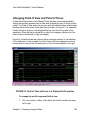
1
DelphMap
User’s Manual
Software documentation through v2.10
June 2004
Copyright Notice
This software is copyrighted and licensed for use on one computer per
copy. Triton Elics International grants permission to the purchaser to
make a limited number of copies of the program for backup purposes.
Additional reproduction of the programs or this manual is a violation of
the copyright law.
The licensee is bound by the terms and conditions set forth in the
Software License Agreement and Limited Warranty that accompanies
this document.
BathyPro™, Isis® Sonar Pipeline, DelphSeismic®, DelphMap®, Survey
Office™, Hydro Suite™, TriPort™, Q-MIPS™, VISTA™, TriCAS™,
ROVFlight™, A-B™, and Convert CD™, are trademarks of Triton Elics
International, Inc.;
Isis® Sonar is a registered trademark of Triton Elics International, Inc.
The following are copyrights of their respective companies or
organizations:
• WinRT Registry: BlueWater Systems
• HawkEye, Imagine 128: Number Nine Visual Technology Corp.
The following are trademarks and/or registered trademarks of their
respective companies or organizations:
• EXB-8500, EXB-8505XLI, EXB-8500C, EXB-8205: EXABYTE
Corporation
• Windows, Windows NT, Windows 95, MS-DOS: Microsoft
Corporation
• Pentium, MMX: Intel Corporation
• Adaptec AHA 1505 and AHA 2940: Adaptec, Inc.
• Klein 5000, Klein 2000, Klein 595: Klein Associates, Inc.
• DF-1000: EdgeTech
• Echoscan, Echotrac: Odom Hydrographic Systems, Inc.
• ADS-640, GSP-1086, EPC-9082: EPC Labs, Inc.
• Sentinel Scribe: Rainbow Technologies North America, Inc.
• mach64: ATI Technologies, Inc.
• HYPACK: Coastal Oceanographics, Inc.
• International Business Machines
• 1200C, DesignJet 650C: Hewlett-Packard
• 1086, 8300, 980x plotters: EPC
• TDU 1200, 850, 2000 plotters: Raytheon
• 195 (same as Dowty 195, Ultra 195 and Ultra 200): Waverley
• InstallShield: InstallShield Corporation
All other brand or product names mentioned in this manual are
trademarks or registered trademarks of their respective companies or
organizations.
Safety Precautions
Please adhere to the hardware and software precautions
mentioned below. In addition, observe all safety precautions
mentioned in this manual.
When working with the overall system
1. Before handling components inside your computer system, exit
all applications and shut down the operating system in
accordance with procedures applicable to them.
2. Turn off the power to the computer and disconnect all cables that
may be feeding electrical power to the system you will be
working on.
3. Wear a grounded, anti-static wrist-strap. This is especially
important if you are removing, replacing, or installing a printed
circuit board of any kind.
Failure to adhere to these and other safety precautions mentioned in the
manual could result in harm to property or personnel!
When working with magneto-optical cartridge disks
• Please refer to the Appendix entitled “Mass Storage Options” for
important details covering the handling of M-O disks!
• Never boot your system with a writable M-O cartridge inserted
into the drive!
• Use magneto-optical media that has 512 bytes per sector, not
1024 bytes per sector, and use the AFDisk software utility to
format magneto-optical media. Never use Windows 95 to
format M-O media!
Triton Elics Internatonal
125 Westridge Drive
Watsonville, CA 95076
USA
[email protected]
(831) 722-7373
© 1991-2004 Triton Elics International, Inc. All rights reserved. Printed in
the U.S.A.
SOFTWARE LICENSE AGREEMENT
By opening this package, you agree to be bound by the terms of this
Agreement, which include the software license and the limited warranty.
This Agreement applies to you and any subsequent licensee of this
software program. If you do not accept or agree to the terms of this
Agreement, do not open this sealed package. Promptly return the
unopened package to TRITON ELICS for a refund. However, no refund
or replacement will be given if the sealed envelope containing the
SOFTWARE Sentinel and Manual has been opened or if any of the
components of the product (including the software sentinel) are missing.
Grant of license for the software product and full title and ownership of
the hardware product shall not transfer to the Buyer until the purchase
price, plus any interest or fees resulting from late payments or prearranged terms, has been received in full by the Seller.
1. GRANT OF LICENSE: TRITON ELICS grants you the right to use
the enclosed TRITON ELICS software product in the manner
provided below.
YOU MAY:
• Use one copy of the TRITON ELICS software products identified
above on a single computer.
• Make one (1) copy of the program in machine-readable form
solely for backup purposes, provided that you reproduce all
proprietary notices.
• Transfer the SOFTWARE and user documentation on a permanent basis provided you retain no copies and the recipient
agrees to the terms of this Agreement.
YOU MAY NOT:
1. Reverse engineer, decompile, modify or disassemble the SOFTWARE
except to the extent such foregoing restriction is expressly prohibited by
applicable law.
Remove any proprietary notices, labels, or marks on the program,
documentation, or program disk.
2. UPGRADES. SOFTWARE and documentation upgrades are provided
free of charge for one year from the date of shipment. If the SOFTWARE
is an upgrade, you may use or transfer the SOFTWARE only in
conjunction with upgraded product. You may use that upgraded product
only in accordance with this License.
3. COPYRIGHT. The SOFTWARE (including any images, “applets,”
animations, video, audio, music, and text incorporated into the
SOFTWARE) is owned by TRITON ELICS and is protected by United
States copyright laws and international treaty provisions.
4. TECHNICAL SUPPORT. Technical Support is available by phone, fax,
modem, Triton Elics bulletin board service or Internet free of charge
during warranty period. MARISAT charges are invoiced at cost plus
twenty percent.
5. EXPORT RESTRICTIONS. You agree that neither you nor your
customers intends to or will, directly or indirectly, export or transmit the
SOFTWARE or related documentation and technical data to any country
to which such export or transmission is restricted by any applicable U.S.
regulation or statute, without the prior written consent, if required, of the
Bureau of Export Administration of the U.S. Department of Commerce, or
such other governmental entity as may have jurisdiction over such export
or transmission.
LIMITED WARRANTY
TRITON ELICS warrants that (a) the SOFTWARE will perform
substantially in accordance with the accompanying written materials for a
period of one (1) year from the date of shipment and (b) any hardware
accompanying the SOFTWARE will be free from defects in materials and
workmanship under normal use and service for a period of one (1) year
from date of shipment.
CUSTOMER REMEDIES. TRITON ELICS’s entire liability and your
exclusive remedy shall be, at TRITON ELICS’s option, repair or
replacement of the SOFTWARE or hardware that does not meet
TRITON ELICS’s Limited Warranty. Warranty service is F.O.B. TRITON
ELICS’s Watsonville facility. All shipping and insurance costs are paid by
buyer. On-site Customer Service and Warranty Repair (including travel
hours, transportation, lodging and meals) may be provided by TRITON
ELICS, at its own discretion, to Buyer at cost plus twenty percent.
However, actual labor hours to provide this service or repair will be free
of charge to Buyer. This Limited Warranty is void if failure of the
SOFTWARE or hardware has resulted from accident, abuse, or
misapplication. Any replacement SOFTWARE or hardware will be
warranted for the remainder of the original warranty period or thirty (30)
days, whichever is longer.
NO OTHER WARRANTIES. Except for the above express limited
warranties, TRITON ELICS makes no warranties, expressed, implied,
statutory, or in any communication with you, and TRITON ELICS
specifically disclaims any implied warranty of merchantability or fitness
for a particular purpose. TRITON ELICS does not warrant that the
operation of the program will be uninterrupted or error free. Some
states/jurisdictions do not allow the exclusion of implied warranties, so
the above exclusions may not apply to you. This limited warranty gives
you specific legal rights. You may have others, which vary from
state/jurisdiction to state/jurisdiction.
NO LIABILITY FOR CONSEQUENTIAL DAMAGES. To the maximum
extent permitted by applicable law, in no event shall TRITON ELICS be
liable for any damages whatsoever (including, without limitation,
damages for loss of business profits, business interruption, loss of
business information, or any other pecuniary loss) arising out of the use
of or inability to use this TRITON ELICS product, even if TRITON ELICS
has been advised of the possibility of such damages. Because some
states/ jurisdictions do not allow the exclusion or limitation of liability for
consequential or incidental damages, the above limitation may not apply
to you.
U.S. GOVERNMENT RESTRICTED RIGHTS. The SOFTWARE and
documentation are provided with RESTRICTED RIGHTS. Use,
duplication, or disclosure by the Government is subject to restrictions as
set forth in subparagraph (c) (1) and (ii) of the Rights in Technical Data
and Computer Software clause at DFARS 252.227-7013 or
subparagraphs (c) (1) and (2) of the Commercial Computer Software—
Restricted Rights at 48 CFR 52.227-19, as applicable. Manufacturer is
Triton Elics International, Inc., 125 Westridge Drive, Watsonville, CA
95076. If you acquired this product in the United States, this Agreement
is governed by the laws of California. If this product was acquired outside
the United States, then local law may apply.
Preface:
Using This Manual
This book is intended for user who wishes to use the DelphMap software
application to create and combine georeferenced images containing
side-scan sonar mosaics, bathymetric DTMs (digital terrain models) and
other data. See the list of supported file formats in Chapter 1, 'Getting
Started with DelphMap,' under the section 'File Types in DelphMap'.
That section also indicates which applications can be used to create
these files.
Because the software explained in this book runs on Windows NT 4.0,
Windows 2000 and Windows XP, you should know how to work in those
environments so you can find, run and exit the programs discussed here.
We use these conventions in the book:
Denotes a warning or caution .
Denotes an import ant statement, tip, or hint.
Contents
PREFACE
CHAPTER 1
......................................................................
v
Getting Started with DelphMap ......................1
Software Installation Notes ..................................... 1
Upgrading to a Newer Software Version................ 3
Solutions to Some Common Problems.................. 5
What DelphMap Does .............................................. 8
File Types in DelphMap ........................................... 8
Protecting Your Project Files .................................. 9
Organizing Directories for a Project....................... 9
Running DelphMap and Making a Project File..... 11
Noting the Parts of the DelphMap Window .......... 12
Understanding the DelphMap Window................. 13
Toolbar Icons .............................................................. 13
Feature Selection Box ................................................ 14
Project Files Window .................................................. 14
Position and Distance Window ................................... 14
Main Display Window ................................................. 15
Overview Window ....................................................... 15
Status Bar ................................................................... 15
Zoomed View Window ................................................ 15
Survey Control Panel.................................................. 15
Customizing the Work Space
16
CHAPTER 2
Icons and Display Tools............................... 17
The Toolbar Icons................................................... 17
Open and Save........................................................... 17
Zoom to Content ......................................................... 17
Zoom In....................................................................... 18
Zoom Out.................................................................... 18
Zoom Rectangle ......................................................... 18
Pan ............................................................................. 19
Measure Tool.............................................................. 19
Edit/Save a Digit ......................................................... 19
Drawing Line Types .................................................... 20
Measure Tool.............................................................. 23
Display a Profile of the Image..................................... 23
Refresh the Screen..................................................... 23
Turn the Cross Cursor On/Off..................................... 23
Metric and Geographic Grids...................................... 24
Change the Color Palette Settings ............................. 24
Bathymetry Processing............................................... 25
Run Classification Module .......................................... 25
Additional Display Aids............................................... 25
General Settings Menu from Main Menu .................... 26
All Settings.....................................................................26
Settings for Files............................................................26
Settings for Tools...........................................................27
Settings for 2D Contacts................................................28
Settings for 3D Contacts................................................30
Settings for Pipe_Span Tracking ..................................32
Reset to Factory Settings ..............................................33
Setting Properties for a Contact Type of Vector Layer 33
Setting Properties for a Digit Type of Vector Layer .... 36
CHAPTER 3
Importing and Exporting............................... 40
Importing Files of Different Resolutions .............. 40
Importing Different Kinds of Files......................... 40
Importing a Background Image................................... 40
Importing a Contact File.............................................. 48
Inspecting Properties of Contact Files ........................ 52
Importing a Pipeline or Pipespan File ......................... 54
Isis Echoing to DelphMap ........................................... 54
Importing a Classification File..................................... 54
Importing an ASCII Point File ................................ 58
Importing a Seismic Profile ......................................... 60
Merging and Exporting Side-Scan Layers............ 60
Exporting a Layer as a File .................................... 64
Creating a Target TIF File in DelphMap ..................... 60
CHAPTER 4
Managing Layers .......................................... 66
Working With Layers Inserted into a Project File........... 66
Loading, Viewing, and Moving Layers
71
Inserting One or More Layers
71
Identifying Mosaicked Images .................................... 77
Viewing Layers ........................................................... 77
Rearranging the Viewing Order of Layers .................. 78
Establishing a Cursor Value Layer .................................. 79
Changing the Way Layers Are Viewed ............................ 81
Simulating ROV Flight or Dredging Routes .................... 82
Changing Other ROV (or Dredging) Symbol
Properties.................................................. 84
Viewing a Single Beam Profile for ROV Activity ......... 87
CHAPTER 5 Working
with Three-Dimensional Contacts.... 88
CHAPTER 6 Displaying
Image Profiles .............................. 96
Overview
....................................................................... 96
Profiles Derive Information from Layer Types................ 97
Changing the Look of Your Display Profile .................... 99
Changing Profile Setup Parameters .............................. 101
Changing Field of View and Point of Focus.................. 103
Generating a Report File................................................. 104
Importing Profile Lines from .DXF or ASCII Files
108
CHAPTER 7
Printing and Comparing ............................. 110
Printing............................................................................. 110
Seeing Differences Between Two Similar Files ............ 112
Making an ‘A-B’ Comparison .................................... 113
Computing Volumetric Differences ........................... 117
CHAPTER 8
TIFF and GeoTIFF Differences .................. 119
A Peek at TIFF and GeoTIFF Differences ...................... 119
Mapping Geo-Coordinates to Images............................ 119
A Look at Geo-Referencing in a World File................... 120
Supported GeoTIFF Projections .................................... 123
Supported UTM/Datum Pairs.................................... 123
Supported Lambert Projections ................................ 123
Unsupported State Planes........................................ 123
Web Sites Covering GeoTIFF Concepts........................ 123
CHAPTER 9
Troubleshooting Problems ......................... 126
Frequently Asked Questions…and Answers................ 126
June 2004 DelphMap™ User's Manual
CHAPTER 1
Getting Started with DelphMap
Software Installation Notes
Typical software installation CD may contain folders like the ones depicted in the
Windows Explorer layout. (See the figure, Typical listing of TEI software
installation folders ’)
FIGURE 1. Typical listing of TEI software installation folders
Chapter 1: Getting Started with DelphMap
1
June 2004 DelphMap™ User's Manual
TEI software is compatible with Windows NT 4.0, Windows 2000, and Windows
XP. The following notes will help you achieve a smooth installation of the
software.
• Please exit from all other applications before running any of the
installation programs.
• You will not be able to complete the installation on an NT4.0 or
Windows 2000 system if you do not have administrator’s rights. All Isis
“black boxes” ship with a user name Isis. In this case the Isis user
name has administrator’s rights and does not require a password.
• Each application is installed by browsing to the appropriate folder (for
example, Isis5.50 Install) on the CD and double-clicking on the
SETUP.EXE file found in that folder.
• TEI recommends that if you have more than one hard drive, you install
the software on the second (usually the D:) drive, using the default
folder names on the CD. You will be given the option to select any drive
during the setup process, select the Custom option and change the
drive letter.
• The first installation on an NT4.0 system requires a re-boot during the
installation; however, this only occurs for the first installation. Under
Windows 2000, no rebooting is necessary during the installation
process. However, you must reboot the system after installing under
Windows NT 4.0.
• For each application, a number of sample data files can be optionally
installed. These files will reside in a subfolder called Demo Files within
each application’s main folder. These special files can be played back
or processed by the relevant TEI applications without a TEI sentinel
being installed. If no sentinel (dongle) is attached, a message displays,
indicating either that a sentinel was not found or that the sentinel is
damaged. However, you can still play back the sample files that come
from the CD.
• In order to run the software in acquisition mode, or to play back or
process other files, you will need a TEI sentinel attached to the LPT1
printer port. Contact TEI if you need a sentinel.
• If the operating system is Windows NT 4.0 or Windows 2000, you will
need to install a sentinel driver. The driver is included on the CD in the
Sentinel folder; a text file, with installation instructions, is in that folder.
• In the case of Windows NT 4.0, Service Pack 5 (or higher) needs to be
installed. Service Pack 5 is on the CD.
Chapter 1: Getting Started with DelphMap
2
June 2004 DelphMap™ User's Manual
• The TEI manuals that are installed with the software are in Adobe
Acrobat PDF format. Acrobat Reader software (required to read the
PDF files) is also on the CD.
• The CD has a number of other folders containing drivers and
applications that could be required; each folder has a text file with more
information.
• To remove the software, use the Add/Remove Programs utility in the
Windows Control Panel collection of utilities.
• The installations make two changes that are not restored when the
programs are removed using Add/Remove Programs. They are:
the addition of a folder called [TEIdlls] in the Windows or
WINNT folder, and
a modification to the PATH environment variable which adds
the [TEIdlls] folder to the PATH. The [TEIdlls] folder can be
safely deleted after all TEI software has been removed.
Upgrading to a Newer Software Version
If you already have a version of the software that you wish to upgrade on your
system, you will see a dialog box inviting you modify, repair, or remove the
software you intend to install. See the figure, Modify, Repair, Remove choices
during installation’ for an example of this kind of dialog box.
Chapter 1: Getting Started with DelphMap
3
June 2004 DelphMap™ User's Manual
FIGURE 2. Modify, Repair, Remove choices during installation
You will need to remove the old version of the software before you will be
permitted to install the new version. To do so, enable the Remove button in the
dialog box and click Next. You can then install the new version by rerunning
setup.exe. As noted above, some items are deliberately not removed during the
uninstall process; doing so can cause problems. If necessary, manually delete
the \TEIdlls folder, but only do this if you are going to re-install all TEI
applications.
Important Note: The Windows Installer will fail to uninstall the software if the
operating system has been upgraded from (for example) Windows 98 to
Windows 2000 after the TEI applications were installed. If you want to upgrade
your operating system, uninstall the TEI programs first, and then re-install the TEI
programs after the upgrade.
Chapter 1: Getting Started with DelphMap
4
June 2004 DelphMap™ User's Manual
Solutions to Some Common Problems
Problem:
Solution:
Problem:
Solution:
Problem:
Solution:
Problem:
Solution:
Problem:
Solution:
Problem:
After about five minutes the installation does not complete and the
Windows desktop does not return.
Try again after using <CTRL+ALT> + <DEL> to shut the system
down and restart. The problem can be caused by applications
running in the background or not being shut down before running the
installation.
Under NT the installation may fail after the first re-boot, with a message that it cannot locate the file SETUP.EXE.
This can occur if the CD ROM drive is slow getting started after the
first reboot. Just use Explorer to double click on setup.exe again, and
the installation will proceed normally.
There is insufficient space on the C: drive, even though D: (or
another) drive has been chosen to install the programs.
Under Windows NT, the Windows Installer needs to build the
complete Installer Engine and files on the C: drive. The file can be as
large as 250 MB for a full installation. Windows 2000 will require
much less space, since the operating system includes the Installer
Engine.
After the Installation completes, you see the message, “The dynamic
link library map.dll could not be found in the specified path…” when
the program is started.
You MUST reboot the system after finishing the installation. This is
necessary so that changes to PATH environment variable can be
applied.
When you try to connect to a serial port in DelphSeismic or
DelphMap, you may receive this message: Serialdll.dll was
previously loaded from an unexpected location…. This will only
occur on a system that has had a previous version of either
DelphMap or DelphSeismic installed.
First close the serial server (if it’s running), then search for the following files: SERIALDLL.INI and SERIALSRV.INI (These are found in
the Windows folder.) When you find these files, delete them.
You may not be able to install all the options (demo files, manuals,
help files) unless you can free enough space on the C: drive.
Chapter 1: Getting Started with DelphMap
5
June 2004 DelphMap™ User's Manual
Solution:
Consider using the Minimum Installations option located on the CD
to install only the programs you need.
Problem:
When first running Isis after installing a new version, you receive an
error message that says your Isis CFG configuration file is out of
date.
This message alerts you that CFG files created with versions of Isis
earlier than this version of Isis are incompatible. Click OK to accept
the message. A new, compatible CFG file will be created during your
current Isis session. In future Isis sessions, the incompatibility
message will no longer appear.
Solution:
Problem:
Solution:
You receive error messages such as The procedure entry point
xxxxxxxxx could not be located in the dynamic link library
yyyyyy.dll when trying to start one of the TEI applications.
This error may occur on a system which has had earlier versions
(prior to Fall 2000) of TEI software installed. Use Windows Explorer
to search for the following files:
About.dll
HydroNavCurve.dll
ASRVAPI.dll
HydroNavInfos.dll
Attitool.dll
HydroNavPlan.dll
AuxDlfDll.dll
HydroTools.dll
Bathtool.dll
ImpObj.dll
Chrutlw.dll
Importxt.dll
CMGBase.dll LinearFeature.dll
D24Param.dll lxtools.dll
DdsErr.dll
TEImap.dll
dxflib.dll
mifutil.dll
Encode.dll
MOSAIC.DLL
EncodeS.dll
Mpx_Country.dll
Geometry.dll
Mpx_llne.dll
geotiff.dll
Mpx_main.dll
HydroNavAtti.dll mpx_map.dll
mpx_mape.dll
Navpntw.dll
Navprcw.dll
Navtools.dll
ObjectDll.dll
ObjectToBdd.dll
Palette.dll
patchtst.dll
PIPETRK.DLL
PitchYaw.dll
Printer.dll
profile.dll
qtclib.dll
SeisDemo.dll
Serialdll.dll
ShpLib.dll
SinglePrc.dll
SpeckleFilter.dll
Speed.dll
TEISplash.dll
TeiGUIExt.dll
TEImpxmap.dll
Tide.dll
TimeTag.dll
TVGAuto.dll
VecPropDll.dll
Vif2xyz.dll
Volume.dll
XtfTools.dll
These files must be unique on the system (that is, there must be only one
instance throughout your entire computer). The installer copies the latest version
to a folder {Windows Folder}\TEIdlls during the installation process. If any files
with the above names are found that are not in {Windows Folder}\TEIdlls, then
you should delete (or rename) them.
Chapter 1: Getting Started with DelphMap
6
June 2004 DelphMap™ User's Manual
With the Summer 2001 release of TEI software,
some DLL names changed to avoid conflicts
with other non-TEI applications. The DLLs that
conflicted were: map.dll and splash.dll. If you
are upgrading from the Fall 2000 release of TEI
software, delete map.dll and splash.dll from C:
{Windows Folder}\TEIDlls.
Note: {Windows Folder} is the folder on your system where the Windows
operating system is installed. For example, C:\WINNT, C:\Windows are
{Windows Folder} types.
Problem: There is no display of the timing parameters in the Delph
Seismic Recording Parameter Settings dialog box, and there is no display of
either the signal window or the pipe display in the Isis pipetracking module.
Solution: This problem can occur with certain “high-end” hardware
accelerated graphics cards such as ATI Rage Pro, and Voodoo 3d Fx.
Right-click on the Windows Desktop, select Properties → Settings →
Advanced → Troubleshooting (or Properties → Settings → Advanced
→ Performance), and reduce the amount of hardware acceleration that is
being used.
Problem: You receive an error message during installation of TEI software.
For example, you may see this message:
Error — Unable to write to temporary location
Solution: You may see that message if you are running certain anti-virus
software, such as Norton (or other brands too). Check to see that you have
disabled your anti-virus software. The solution is to temporarily turn off
Norton Auto-Protect:
1. Right-click the Norton icon (or other anti-virus icon) on the Windows
taskbar.
2. Select Disable Auto-Protect when prompted.
3. Resume installing your TEI software.
Chapter 1: Getting Started with DelphMap
7
June 2004 DelphMap™ User's Manual
4. When the installation completes, re-boot your PC.
5. When the system restarts, Norton Auto-Protect will be re-enabled by
default.
What DelphMap Does
Starting with one or more files DelphMap recognizes ‘File Types in DelphMap’),
DelphMap displays one or more “layers” of multiple, geocoded sonar imagery, or
color-coded DTM (Digital Terrain Model) imagery, and bathymetry contour vector
graphics. The imagery displays according to the geo-coding in the file or files,
creating a mosaic. If the mosaic contains multiple layers, they can be
superimposed over any other layer.
File Types in DelphMap
In order to display images in DelphMap, you first create a DelphMap project. A
project file contains no actual imagery, either vector or raster; instead, a project
file contains a list of references and path information to the various files that may
be present in a DelphMap project. Project files are denoted by the filename
extension DMP. A .DMP file is created by DelphMap whenever a project is
saved.
You put DelphMap images into a project file either by inserting files as layers or
by importing them into a DelphMap project.
Types of files that can be inserted as layers directly into a DelphMap project:
*.AIF,*.VOB
*.BSB
Older versions of mosaic files.
a non-TEI, proprietary image format for navigational charts
*.CLA
*.DDS_VIF
Questor Tangent Classification (QTC) files.
Generated by BathyPro (processed bathymetry data as a DTM)
or generated by Isis Sonar (SSS imagery). This Visual
Information File (VIF) can contain many sublayers, enabling the
merging of different data types for display in DelphMap. For
example, a single .DDS_VIF could contain both bathymetry
(topographical) and side-scan sonar (non-topographical) data.
AutoCAD Drawing Exchange Format, (up to and including
version R14), vector graphics, labels, lines, shapes.
Electronic Navigational Chart format
*.DXF
*.ENC
Chapter 1: Getting Started with DelphMap
8
June 2004 DelphMap™ User's Manual
*.PCM
*.SHP
Pulse Code Modulation photo image file
ESRI® ArcView Shape files.
Types of files that can be imported directly into a DelphMap project:
*.CON
*.DDS_VOB
Contact files generated by Target or TargetPro.
Vector layers, along with a DDS_VIF file containing a visual
image.
*.DXF
Seabed Classification files generated by SeaClass (an instance
of a DXF file).
*.SPN
Span files generated from the Pipe Tracking module in Isis.
*.TIF,*.BMP,*.JPG As background imagery; typically aerial photographs or
charts.
Note: From version 2.9 on, a .DDS_VIF file containing sidescan sonar imagery
will have an accompanying .DDS_VOB vector file containing the vessel’s track.
Protecting Your Project Files
When you run DelphMap, it creates and modifies several files unique to the
program. Foremost among these files is the Delph project, a file having the
extension DMP. After you have specified a DMP Delph project, DelphMap
creates additional files in the same directory (folder) where the Delph project is
created, or in additional directories you have set up and specified to DelphMap
(see ‘Organizing Directories for a Project'),
Do NOT delete, rename, or move any DelphMap
files from the directories where they are created.
Organizing Directories for a Project
In the course of building a project, DelphMap creates a number of files. You’ll find
it easier to keep track of things if you create directories dedicated to the project
you make. All files supporting the project files can be redirected to subfolders of
the project folder.
Procedure for setting up a series of DelphMap project folders
Chapter 1: Getting Started with DelphMap
9
June 2004 DelphMap™ User's Manual
1. In Windows Explorer, create a parent folder (directory) to hold your
DelphMap project (DMP) file.
2. In Windows Explorer, create child folders — one for each type of file
and/or layer to be inserted/imported.
For example, you might create a subfolder for your contacts, a subfolder
for your bathymetry and/or side-scan sonar files (DDS_VIF), another for
your XTF files, one for your DXF files (if any), and so on. Such an
arrangement would produce one parent folder and some child folders.
Figure 3 shows an example of this.
FIGURE 3. Project Parent Folder and Five Arbitrary Child Folders
In the example shown in Figure 3, the DemoWreck folder is the parent
folder and will contain the DMP file for this sample project.
3. Copy the different files you wish to include in your project into the
appropriate child folders for this project.
4. Run DelphMap (double-click the DelphMap icon or file name to run
it).
5. From DelphMap’s main menu click Settings → Files and specify the
folder you created in step #1. This will become your working
directory for this project.
6. Create a new DelphMap project file name to be associated with the
project you are creating: filename.DMP — where filename.DMP is
the name of the project you are creating, such as MyProject.DMP.
As you do this, visually verify that filename.DMP is being created in
the parent folder specified in step #1.
Chapter 1: Getting Started with DelphMap
10
June 2004 DelphMap™ User's Manual
7. One at a time, import file(s) or insert whatever layers will be part of
your project. Specify one of the previously created and appropriate
child folders to hold the contents of the layer or file. If you are adding
layers to your project, make sure that the layer names you assign to
them are unique. See ‘Working With Layers Inserted into a
Project File’.
Running DelphMap and Making a Project File
Before DelphMap can create your mosaic, DelphMap first needs to establish a
project file or DMP file.
To run DelphMap and establish a project file
• Double-click the DelphMap icon to run it.
DelphMap runs and displays an application window similar to the one shown
in Figure 4, with a default name of NewProject.dmp as the project name.
You can accept that project name or specify one of your own.
To specify a different project name
1. From the DelphMap main menu, choose Project → New Project.
DelphMap displays a dialog box where you can specify a project file to
open or create.
2. Provide a primary file name for the project. This can be an existing
DMP file, or you can let DelphMap create it. DelphMap provides the
file extension DMP, which stands for DelphMap Project. The DMP
file acts as a container for any layers you may add or remove.
3. Click Save after you have selected or typed the name of the project
file.
The project file loads and the system displays the DelphMap application
working window. If the project file already exists, its contents are
displayed here. If the project file is new, the work space in DelphMap is
initially empty (Figure 4).
To open an existing project
1. From the DelphMap main menu, click the Open icon:
Chapter 1: Getting Started with DelphMap
11
June 2004 DelphMap™ User's Manual
DelphMap displays a dialog box where you can specify a project file to
open.
2. Specify the file name by either typing it or browsing for it from this
dialog box.
To save a project file
• From the DelphMap main menu, click Save or Save As…
If you click Save, the system saves your project as it currently is displayed,
without further prompting. If you click Save As…, the system prompts you
for a file name. The Save As… feature may be particularly useful if you
anticipate making more changes to your current DMP project file, in that
DelphMap does not have a “close without saving” function — that is,
projects are automatically saved upon exiting DelphMap.
Noting the Parts of the DelphMap Window
The DelphMap application window displays several parts you can work with.
Figure 4 shows a sample application window with parts labeled.
Chapter 1: Getting Started with DelphMap
12
June 2004 DelphMap™ User's Manual
2
1
(Zoomed View
Window)
8
(Survey
Control
3
Panel)
(Main Display Window)
9
4
(thumbnail view
of main window)
7
FIGURE 4. Major parts of the DelphMap application window
Understanding the DelphMap Window
The parts of the DelphMap application window are explained next. The
explanations are associated with the callout numbers shown in Figure 4.
Toolbar Icons
Area 1of Figure 4. All the toolbar icons are explained in Chapter 4,
'Managing Layers,’Error! Bookmark not defined.. (Some of the same
functionality also can be accessed through the application’s main menu.)
Toolbar icons are grouped into two main chunks: the display set of icons,
and the standard group of icons. Both sets of icons are movable and
dockable, but not resizable (see ‘ Customizing the Work Space’).
Chapter 1: Getting Started with DelphMap
13
June 2004 DelphMap™ User's Manual
Feature Selection Box
Area 2 of Figure 4. From this drop-down box you can select one of seven
different descriptive names for labeling aspects of the imagery that you have
demarcated with DelphMap drawing tools. You also can create custom
names for features by typing over the currently highlighted name in the box
and then pressing <Enter>.
Project Files Window
Area 3 of Figure 4. Initially, the Project Files Window displays only the
project name with a plus sign to the left, indicating a “collapsed” (nonexpanded) status. The named project in this window is expandable and, if
already expanded, then it is collapsible. An expanded project name displays
one or more of its layers, depending on the degree of user-selected
expansion. If the layer’s file name and path goes beyond the right edge of
the Project Files Window, you can slide the horizontal slider bar at the
bottom of this window to see the obscured part of the layer’s file name and
path. Alternatively, if you place your cursor on a file name, DelphMap
displays the entire file name and path. The window is movable and
dockable, but not resizable (see ‘Customizing the Work Space’). The
hierarchy of the entities displayed in the Project Files Window is as follows,
from top to bottom level:
1. project name (as user-defined filename.DMP)
2. image layers (if any; user-defined)
3. vector layers (if any; user-defined)
4. background layers (if any; user-defined)
DelphMap displays the file name of the layer below the name of the layer
that has been inserted into the project.
Position and Distance Window
Area 4 of Figure 4. Referring once again to the figure, the top four lines of
the Position and Distance Window continuously display the current coordinates of the cursor, both in eastings and northings and in
latitude/longitude. The bottom two lines display the distance and heading
when this function is selected from the toolbar. The window is movable and
dockable, but not resizable (see ‘Customizing the Work Space’).
Chapter 1: Getting Started with DelphMap
14
June 2004 DelphMap™ User's Manual
Main Display Window
Area 5 of Figure 4. The largest area of your DelphMap application window,
the Main Display Window contains the large view and detail of your map.
The window can be resized but not moved, docked, or redocked from its
initial position (see ‘Customizing the Work Space’).
Overview Window
Area 6 of Figure 4. Shows a thumbnail of the image layers. The size of this
image remains constant even if you zoom in our out of the image in the
Main Display Window. If you use the trackball to draw a rectangle around
some part of the image in the Overview window, the image in the main
window resizes to the dimensions of the area defined by the drawn
rectangle in the Overview Window. The window is movable and dockable,
but not resizable (see ‘Customizing the Work Space’).
Status Bar
Area 7of Figure 4. This static and fixed part of the bottom of the screen
displays system messages regarding the status of the program, any errors,
etc. This window is immovable and therefore not redockable. However, you
can hide/unhide it by unchecking/ checking the Status window from the
View menu. This component of the window cannot be moved or resized.
Zoomed View Window
Area 8 of Figure 4. This functionality is accessed from the main menu as
View → Zoomed View window. When activated, the Zoomed View window
displays a user-selectable degree of magnified or minified view of whatever
imagery currently is in the Main Display Window, tracked to the cursor
position when the cross-hair cursor icon (“Turn Cursor On/Off”) is set to On
(as indicated by the indented view of the cursor icon). When you make this
window and the cross-hair cursor icon active, the resulting display makes it
easy to see both the context and the zoomed content of the imagery at the
cursor position.
Survey Control Panel
Area 9 of Figure 4. This part of the application window, known as the Survey
Control Panel, controls DelphNav. DelphNav is an optional, fully functional
navigation package that works with DelphMap. If you purchased DelphNav,
Chapter 1: Getting Started with DelphMap
15
June 2004 DelphMap™ User's Manual
see the separate technical manual, Using DelphNav, provided by Triton
Elics International, for the functionality of this part of DelphMap.
Customizing the Work Space
From the View menu, all visible parts of the application window, except for the
main display area, can be turned on or off by placing a check mark next to the
named view. By default, all viewable items are initially displayed, and thus all the
choices in the View menu initially have a check mark next to them. The menu bar
at the very top of the screen is always visible.
In addition, except for the status bar, the main display area, and the main menu
list, any of these items can be docked or redocked. This means you can move
the items to any other part of your screen independently of the main application
window if you click on an edge of the item and drag it to any other area on your
screen. If you move an item out of the DelphMap application window, the
imagery in the large part of the application window adjusts and redraws to make
use of the space vacated by the item you moved. If you move an item currently
residing outside the application window back into the DelphMap work area, the
large display area again adjusts and redraws to occupy available space.
If you place your pointer over a toolbar item, a tool tip (also known as quick tip,
balloon help or bubble help) displays under the item, identifying its purpose.
Chapter 1: Getting Started with DelphMap
16
June 2004 DelphMap™ User's Manual
Chapter 2 Icons and Display Tools
Using icons and other display tools, DelphMap has several controls for working
with imagery. This chapter explains those controls.
The Toolbar Icons
Most of the display manipulations can be done conveniently from icons
appearing in a toolbar underneath DelphMap’s main menu. Many of the functions
represented by the icons are also available as text choices from DelphMap’s
menus.
Most icons are unique to DelphMap. For the layout order of the icons on the
toolbar, please refer to Figure 4, ‘Major parts of the DelphMap application
window,’. This section you are reading describes the icons according to features
they have in common, without regard to the order that they appear on the toolbar.
Open and Save
The Open (left) and Save (right) icons are the same as those
available to most Windows applications. In DelphMap, choosing the Open
icon gives you a way to change a project or create a new one. Similarly,
choosing Save saves the current project.
Zoom to Content
The Zoom to Content function refreshes the screen and recenters
the imagery in the main display area to display the entire mosaic at a size
approximately one-fourth the square area of your main display window. The
keyboard shortcut is [F6]
Chapter 2: Icons and Display Tools
17
June 2004 DelphMap™ User's Manual
Zoom In
The Zoom in function magnifies the image in your main display area
by a factor of two and moves the image away from the midpoint of the main
display window by twice the distance from the current position. Keyboard
shortcut: [Num] [+].
Note:
It is possible to zoom your image beyond the edges of the main
display window, where you won’t be able to see it. If this happens to you,
either click the Zoom to Content icon or draw a rectangle around some part
or all of the image in the Overview window. The image will reappear in the
main display window.
Zoom Out
The Zoom out function shrinks the image in your main display area
by a factor of two and moves the image halfway between the midpoint of the
main display window and the image’s current position. Keyboard shortcut:
[Num] [-].
Note:
It is possible to make your image so small by repeated clicking of
Zoom out that you no longer can see the zoomed out image. If this
happens to you, either click the Zoom to Content icon or draw a rectangle
around some part or all of the image in the Overview window. The image will
reappear in the main display window.
The next four functions — Zoom rectangle, Pan, Measure Tool, and
Display profile — are designed to be mutually exclusive; choosing any one
of them excludes the others from being operational at the same time.
Zoom Rectangle
You use the Zoom rectangle function to draw a rectangle with your
mouse or trackball around some part of your imagery (either in the Overview
or Main Display Window). When you do this, your main display window is
filled with the image in the dotted line rectangle. If you decide not to use this
Chapter 2: Icons and Display Tools
18
June 2004 DelphMap™ User's Manual
function, click the icon again to return the icon to a non-selected state.
(Choosing a different icon also deselects this icon.)
Pan
Use the Pan function to reposition the imagery in your main display
window. After clicking the icon, left-click your mouse or trackball in your
imagery and then draw a line in the direction you wish to move the image —
the longer the line, the greater the shifted distance of the image in the
display window. The line does not have to be touching (but can be touching)
any part of the image. If you decide not to use this function, click the icon
again to return the icon to a non-selected state. (Choosing a different icon
also deselects this icon.)
Measure Tool
The Measure tool function enables measurement of range and
bearing between points on the image. When you left-click and draw a line in
the main display window, DelphMap displays the imagery’s distance and
heading in the last two frames of the Position and Distance window. The
reported values are “sticky”; that is, they remain displayed until you click
again in the image to establish a new distance and heading. If you decide
not to use this function, click the icon again to return the icon to a nonselected state. (Choosing a different icon also deselects this icon.)
Edit/Save a Digit
With this icon you can create, edit, and save points or vector lines
as a vector layer. Clicking this icon enables the Draw a Point icon and the
icons for three drawing line types, which you can use to plot waypoints or
profiles of your imagery. You can also access this function from the main
menu by choosing Tools→Digit→Start/Stop Digit.
Chapter 2: Icons and Display Tools
19
June 2004 DelphMap™ User's Manual
Drawing Line Types
If you have enabled the Edit/Save a Digit function, you
can then choose a line drawing tool shown here. Reading from left to right,
the drawing tools are: draw a polyline, draw a point, draw a rectangle, and
detect image regions. All line types are mutually exclusive to each other.
Before you use this function, you might want to select or create a label in the
Feature Selection combination box that you wish to associate with the points
or lines you intend to draw. These functions also are available from the Digit
menu.
Draw a polyline. This enables the user to create an open or closed polyline.
A closed polyline can be filled with a regional fill pattern.
Draw a point. This creates individual points; the shape of the point style can
be changed by the user.
Draw a rectangle. Using a left click and dragging the cursor, the user can
create rectangles of any size.
Detect Image Regions. This function is designed as an interpretation tool
to detect a region of interest. It works best on objects that have a high
contrast, such as a high intensity wreck on a low intensity sea floor. It
detects regions by taking a starting sample (the pixel you clicked on), than
searches the surrounding pixels until it encounters pixels that are less than
3dB from the original pixel. All the surrounding pixels that meet the criteria
are included in the region.
To draw a vector line or shape on your imagery
1. Enable Edit/Save a Digit.
2. If this is the first time you have selected this function in a project, you
will be prompted to select a Digit file you want to Open or Create. If
this is a new project or you want to start a new Digit file, create a
Digit .vob file by entering a file name. If however, you have a
previous Digit file that you would like to add to, browse and select the
previously created Digit file.
Chapter 2: Icons and Display Tools
20
June 2004 DelphMap™ User's Manual
3. Select (or create) a label to be associated with the points or lines you
intend to draw, which you can do from the Feature Selection Box
(see page 18).
If you drew a polyline or polygon, right-click after you’re through drawing
the point or shape; doing so displays a menu of these choices: Save;
Edit Object ; Delete Point; Close object; Quit; Delete Object; Copy;
Paste.
Choose one of those actions.
4. Choose one of the drawing line types from the Tools Palette.
5. Drag or click your pointer in the main display window working area to
complete the chosen type of vector graphic.
The completed vector lines now appear in the imagery where you drew
them. A label from the Features Selection Box appears next to the
shape, line, or point.
To spline smooth vector lines and shapes
The spline function is located as line type number 5 in
Vector→Properties→Settings. Figure 5 shows the line type options box.
Chapter 2: Icons and Display Tools
21
June 2004 DelphMap™ User's Manual
FIGURE 5. Spline option located as line type in
Vector→Properties→Settings
Chapter 2: Icons and Display Tools
22
June 2004 DelphMap™ User's Manual
Measure Tool
The Measure tool function enables measurement of range and
bearing between points on the image. When you left-click and draw a line in
the main display window, DelphMap displays the imagery’s distance and
heading in the last two frames of the Position and Distance window. The
reported values are “sticky”; that is, they remain displayed until you click
again in the image to establish a new distance and heading. If you decide
not to use this function, click the icon again to return the icon to a nonselected state. (Choosing a different icon also deselects this icon.)
Display a Profile of the Image
Normally, you view your imagery from the top down (“bird’s-eye”
view). DelphMap can also display your imagery in a side view. See
Chapter 6, ‘Displaying Image Profiles’, for a comprehensive explanation of
this function
Refresh the Screen
The Refresh function merely refreshes the screen. Unlike the Zoom
to Content function, Refresh does not reposition the imagery from its
current position, nor does it resize the image. The keyboard shortcut: [F5]
Turn Cursor On/Off
In DelphMap, your cursor can be a conventional white arrow (the
default) or a white cross. If you enable the white cross cursor, any cursor
movement done in the Main Display Window is echoed in all View Layer
windows, as long as “Synchronize Map scale and position” is turned on in
Settings→Tools. Cursor movement is not tracked in the Overview Window,
unless the cursor is activated in Settings→Tools. As the icon’s name
implies, the Turn cursor on/off function toggles on or off.
Chapter 2: Icons and Display Tools
23
June 2004 DelphMap™ User's Manual
Metric and Geographic Grids
Clicking this icon displays a dialog box for two types of gridding —
metric or geographic — each of which can be set independently of one
another (or not set at all). The keyboard shortcut is <CTRL+G>.
• When geographic gridding is enabled, DelphMap superimposes a
geographical grid over your imagery. Grid intervals are in seconds.
• When metric gridding is enabled, DelphMap superimposes a metric grid
over your imagery. Grid intervals are in meters.
For either type of grid, you can change the intervals to get more or fewer
grid lines (thereby increasing or decreasing the density of the grid).
Note:
Choose a grid interval suitable for the area covered by your
imagery. If you choose a very small grid interval for imagery that covers a
large area, your system may take a long time to draw the grid.
Change the Color Palette Settings
Clicking this icon displays a dialog box where you can define a color
palette and palette density for each of five data types: side-scan,
bathymetry, seismic reflector, volume, and user-defined. The data types
present in the palette window correspond to the data types that are currently
displayed in the main GIS window. If no layer is present, then all data types
appear. If some of your data displays without sufficient visual definition, this
visual aid can help boost the values of your low intensity data to make them
stand out more. Choose a color and density that gives you the best visual
results. If you select user-defined to create your own palette, the system
displays a separate dialog box where you specify minimum and maximum
values to be applied to your designed palette.
Some combinations of color palettes are especially effective for side-scan
and bathymetry data types:
• for side-scan: copper, gray or pink palettes yield excellent image detail.
• for bathymetry: just about any palette works well.
To apply the color combinations to your image, be sure to match the correct
data type to your image.
Chapter 2: Icons and Display Tools
24
June 2004 DelphMap™ User's Manual
Bathymetry Processing
If you have purchased the BathyPro utility from Triton Elics
International, this BathyPro icon is enabled. Clicking it summons the
DelphMap-BathyPro application where you can process, either interactively
or in batch mode, single beam and multibeam data, resulting in output of
DDS_VIF or DXF files that can be re-imported into DelphMap for more
processing. You can also get to this function by choosing Applications→
Bathymetry processing from DelphMap’s main menu.
Run Classification Module
If you have purchased the Classification utility from Triton Elics
International, this Classification utility icon is enabled. You use it to generate
a map of the surrounding seafloor. You can also get to this function by
choosing Applications→Seafloor classification from DelphMap’s main
menu. The SeaClass functionality is documented in the Using SeaClass
User’s Manual, distributed as a PDF file on a CD.
Manage Layers
If you have multiple layers within a DelphMap window or project,
you can invoke the layer management capability by clicking on this icon.
The layer management dialog allows the user to make collective changes to
the layers. User can delete, hide, display or reorder vector and image
layers within the DelphMap project. You can also access this function by
choosing Tools→Manage Layers from DelphMap's main menu.
Additional Display Aids
Some DelphMap icons and menu choices exist simply to help you see the
imagery more clearly. The Settings dialog box, accessible from a vector layer’s
Properties choice, is an example of this. The DelphMap Settings dialog box
available from the main menu is another example. Among icons, the Refresh
Chapter 2: Icons and Display Tools
25
June 2004 DelphMap™ User's Manual
icon, the Cross Cursor icon, the Metric and Geographic Grid icon, and the Color
Palette icon also are examples of additional display aids.
General Settings Menu from Main Menu
From DelphMap’s main menu you can summon dialog boxes where you can
specify settings affecting imported files, colors to be used in displaying various
objects in DelphMap and settings to be applied to 2D and 3D Contacts. Such
settings apply to all layer types.
All Settings
If you choose All Settings , you get a dialog box with five tabs — one for
Files, Tools, Pipe & Span Tracking, 2D Contacts and 3D Contacts.
Alternatively, you can choose separate dialog boxes for each of the named
tabs directly from Settings in the main menu.
Settings for Files
DelphMap has three settings that you can change or set for files. The
choices become available from the main menu by choosing Settings→Files
or by choosing Settings→All Settings and then selecting the Files tab. The
current Working Folder path is displayed and to change it, click on the
ellipsis button. This brings up the Windows file browse dialog.
• Working Folder - The directory set here becomes the default directory
for DelphMap to open files from, and to place files generated by the
current project. This is also where the DelphMap project .dmp and
.dds_mpf files are stored.
Open the Last Opened Project on Startup - This does exactly what is
says, once a checkmark has been put in the box and the project is saved.
The next time DelphMap is opened, the current project will automatically be
loaded.
When inserting vector or single-band image layers, don’t ask for a
layer name. - This represses the insert dialog box that asks for a layer
name when inserting certain file types.
An unchecked box (setting disabled) is the default condition for this
parameter for these last two options.
Chapter 2: Icons and Display Tools
26
June 2004 DelphMap™ User's Manual
Settings for Tools
A dialog box for tools settings for can be reached from the main menu via
Settings→Tools or by choosing Settings→All Settings and then selecting
the Tools tab. Figure 6 shows the dialog box as selected from the Tools tab
of the All Settings menu.
FIGURE 6. Delphmap Settings dialog box (Tools tab)
Chapter 2: Icons and Display Tools
27
June 2004 DelphMap™ User's Manual
From the Browse buttons (
) next to any of eight objects associated with
the DelphMap application window, you can change the colors to be
associated with the objects, as
Display the Cursor in the Overview Window, and
Synchronize Map Scale and Position
Display the Cursor in the Overview Window means that cursor activity
also appears in the Overview Window if the Turn Cursor On/Off icon is
enabled in either the Overview Window or the Main Display Window. An
unchecked box (setting disabled) is the default condition for this parameter.
Synchronize Map Scale and Position means that when you make a
change to an image in the current Overview Window, those changes are
also made in the Main Display Window. When changes are coordinated this
way, it becomes easier to see the effect of your changes in the context of
the composite image in the Main Display Window. An unchecked box
(setting disabled) is the default condition for this parameter.
Settings for 2D Contacts
From TargetPro, there is the option of automatically importing saved
contacts into DelphMap. The option whether or not to import is found in
TargetPro under Tools→ Configuration. However, from within DelphMap,
there are several options for how to import the contact.
Chapter 2: Icons and Display Tools
28
June 2004 DelphMap™ User's Manual
FIGURE 7. 2D Contacts dialog box
Confidence Radius. When a contact is imported, or generated from within
DelphMap, a circle is drawn around the target position. The radius of this
circle represents theh confidence the user has in the target’s position. The
default radius is 3 meters. Circles of different radii are possible in the same
DelphMap project.
Chapter 2: Icons and Display Tools
29
June 2004 DelphMap™ User's Manual
Folder name to store geocoded image. When importing a contact, the
user has the option of creating a geocoded image of the contact. A
geocoded image looks something a mini-mosaic of the contact. You need to
specify where to store these files; the default directory is the directory where
the DelphMap executable file (.exe) is found, or the last directory set from a
previous DelphMap project. To change the path and directory, click on the
) to bring up the Windows file browse dialog.
browse button (
Create a Geocoded Image. You have the option to automatically create a
geocoded image when importing the contact. If this box is unchecked, no
geocoded image will be created.
Input Geodesy. The geodesy set here is the projection of the incoming
contact from Isis and TargetPro. The incoming projection is NOT always the
same as the projection of the DelphMap project. For example, the
DelphMap project will always be in a grid projection such as Universal
Transverse Mercator (UTM), State Plane or Mercator. Quite often, the data
is collected in Latitude/Longitude, which is not projected. If your data was
collected in Latitude/Longitude, ou would want to set the Input Geodesy to
be Not Projected (Longitude, Latitude). If your contact is imported into
DelphMap and is placed far from the rest of your contacts and layers,
double check this input geodesy.
Settings for 3D Contacts
You use DelphMap’s 3D Contacts feature to examine your imagery in threedimensional perspectives and, optionally, to take a digital picture of the
viewed 3D imagery. Controls affecting this capability are found in the
3D Contacts dialog box, accessible from the main menu by choosing
Settings→3D Contacts or by choosing Settings→All Settings and then
selecting the 3D Contacts tab. Figure 8 shows the dialog box.
Chapter 2: Icons and Display Tools
30
June 2004 DelphMap™ User's Manual
FIGURE 8. 3D Contacts dialog box
Displaying 3D contacts can be memory-intensive. If you get a DelphMap
message that says you don’t have enough memory to view your imagery
three dimensionally, adjust the northing and easting extensions in the
3D Contacts Size fields of the 3D Contacts dialog box to use smaller
extents. The default size is 10 meters. In this dialog box you also can
specify one of four file formats to be used for any snapshots of 3D imagery
that you make: BMP (the default), TIF, TGA, or PCX.
Chapter 2: Icons and Display Tools
31
June 2004 DelphMap™ User's Manual
Settings for Pipe & Span Tracking
You use the Pipe Span Tracking tab of the DelphMap Settings dialog box
to choose the color scheme for three parameters affecting pipeline objects
found in imagery: Exposed, Half-Buried, or Buried. From the Pipe Span
) next to a parameter to get a
Tracking tab, click a Browse button (
table of colors from which you can choose a color to be associated with that
parameter; then click OK to set the color. Figure 9 shows the dialog box.
FIGURE 9. Pipe Span Tracking tab in DelphMap Settings dialog box
Chapter 2: Icons and Display Tools
32
June 2004 DelphMap™ User's Manual
Reset to Factory Settings
If you are experiencing unexpected behavior from DelphMap, consider
choosing Reset to Factory Settings as a way out of the difficulty. If you
choose this, any settings you may have established in DelphMap during this
session or a previous session are overridden by the original factory settings.
Setting Properties for a Contact Type of Vector Layer
If you have a vector layer inserted and present in your imagery, certain
settings can also be viewed or applied to that layer. These settings differ
from the general settings described earlier in ‘General Settings Menu from
Main Menu’. Moreover, the settings for contact layers and digit layers are
laid out differently in their respective dialog boxes. All vector types have the
same types of properties, however. Settings dialogs for contact and digit
layers are explained next.
To view file information for a contact type of vector layer
1. Right-click on a vector layer name in the Project Files window.
2. Choose Properties .
The system displays the Settings dialog box for the selected contact
layer. Initially the File(s) tab is in the foreground (Figure 10). This
window has no user-accessible parts to it; it just shows properties of the
current layer. Note that this dialog box is the only access path to the
Settings tab for vector layers.
Chapter 2: Icons and Display Tools
33
June 2004 DelphMap™ User's Manual
FIGURE 10. File(s) tab area of the Settings box for vector layers
To set properties for contact objects and their labels
1. Right-click on a vector layer name of a contact type in the Project
Files window.
2. Choose Properties .
The system displays the Settings dialog box, with the File(s) tab in the
foreground (Figure 10).
3. Click the Settings tab in the Settings dialog box.
The system displays the Settings tab area of the Settings dialog box
(Figure 11).
Chapter 2: Icons and Display Tools
34
June 2004 DelphMap™ User's Manual
Green check marks initially appear in boxes indicating that whatever
properties are specified here will be set for objects and labels. If you click
on a green check mark, it turns to a red "X" indicating that you will be
suppressing that option in your imagery. Clicking a box again reverses
this action.
In the Object color area, you can set the properties for Objects color,
Line Style, Point Symbol, and a Region Fill Pattern. In the Labels
color area you can specify a color and font size to use.
FIGURE 11. Settings dialog box for a contact type of vector layer
Chapter 2: Icons and Display Tools
35
June 2004 DelphMap™ User's Manual
You can suppress or enable those colors, independently of each other,
although it is advisable to make the Objects color and Labels Color
match; that way, it will be easier to distinguish objects and their labels in
your imagery. Also, if you are enabling an object and/or its color, it’s a
good idea to increase the Font Size so that the labels are easily
readable in the imagery. We recommend a Font Size setting of
10.000000 m.
4. After inspecting the colors currently assigned to the seabed objects
and their labels, click or don’t click on the boxes controlling those
features in order to enable or suppress the features, as desired.
Setting Properties for a Digit Type of Vector Layer
All of the properties that can be set for a contact layer can also be set for a
digit layer. A digit layer’s properties are laid out differently in its settings
dialog box, however.
To view file information for a digit type of vector layer
1. Right-click on a vector layer name in the Project Files window.
2. Choose Properties .
The system displays the Settings dialog box for the selected digit layer.
Initially the File(s) tab is in the foreground. The dialog box is identical to the
dialog box shown in Figure 10 except that the names of the files in the
Dependencies portion of the dialog will be those pertaining to digit layer files
instead of contact layer files. This window has no user-accessible parts to it;
it just shows properties of the current layer. Note that this dialog box is the
only access path to the Settings tab for vector layers.
To set properties for digit objects and their labels
1. Right-click on a vector layer name of a digit type in the Project Files
window.
2. Choose Properties .
The system displays the Settings dialog box, with the File(s) tab in the
foreground (Figure 10).
3. Click the Settings tab in the Settings dialog box.
The system displays the Settings tab area of the Settings dialog box. An
example is shown in Figure 12.
Chapter 2: Icons and Display Tools
36
June 2004 DelphMap™ User's Manual
FIGURE 12. Settings dialog box for a digit type of vector layer
In the Settings tab area of the dialog box (example shown in Figure 12), you
can modify the properties for the digit layer by changing the colors of the
digit’s object and its labels, by giving the object a different line style, by
assigning a region fill pattern, and by specifying a font size. Each of these
properties can be set independent of the other properties.
4. Click OK in the Settings dialog box if you made any property changes
and wish to apply them to your digit layer; otherwise click Cancel.
Chapter 2: Icons and Display Tools
37
June 2004 DelphMap™ User's Manual
To assign colors to labels or objects in layers
1. Right-click on a vector layer name in the Project Files window.
2. Choose Properties .
3. Click the Settings tab in the Settings dialog box.
4. Click the right-pointing marker (►) next to an Objects color or
Labels Color you wish to change.
The system displays a Color dialog box (Figure 13) containing a matrix of
48 basic colors and 16 uncolored boxes reserved for custom colors that
you can define.
FIGURE 13. Color dialog box for changing objects or labels colors
5. Do one of the following:
• Click a basic color and click OK, or
• Click Define Custom Colors >> to expand the Color dialog box,
where you can specify a non-basic color. You do so by clicking in the
graduated color box or by typing values for Hue, Saturation, and
Luminosity (or by typing values for Red, Green and Blue); then click
OK.
Chapter 2: Icons and Display Tools
38
June 2004 DelphMap™ User's Manual
For each of the remaining layers whose colors you wish to change,
repeat the procedure ‘To set properties for contact objects and their
labels’ and the procedure ‘To assign colors to labels or objects in
layers’. When you have finished doing that, the seabed classification
objects you imported into your imagery displays fully labeled and colored
as you specified. Figure 21 shows an example of this treatment.
Chapter 2: Icons and Display Tools
39
June 2004 DelphMap™ User's Manual
Chapter 3 Importing and Exporting
DelphMap can import a number of different types of files as layers to form
imagery. DelphMap can also export layers as a single file, making the result easy
to work with as a single entity.
Importing Files of Different Resolutions
Files of different resolutions can be imported into DelphMap. These include
bathymetry, mosaic images and seismic profiles. For example, a mosaic image
file with a resolution of 0.25 m can be inserted into a DelphMap project that
contains a mosaic image with a resolution of 0.20 m and a bathymetry layer with
a resolution of 0.5 m. The resolution displayed under Project→Project
Information will be that of the layer with the highest resolution in the current
DelphMap project.
Importing Different Kinds of Files
Certain types of files must be imported in a special way so that they can be
redisplayed properly in DelphMap. These include contact files, pipeline or
pipespan files, seabed classification files, ASCII points with labels, seismic profile
files, and photo image files. Once a file is imported, it becomes part of the
composite image appearing in DelphMap’s main display window. Other types of
files planned for later importation into DelphMap are pipe span files and
classification files.
Photo image files are of type PCM (Pulse Code Modulation). For further
information about importing a photo image layer, please contact TEI Technical
Support (831.722.7373).
Importing a Background Image
DelphMap can import the following files types as background layers:
TIFF
BSB
If you have an appropriate background image that has the same kind of
geodesy as other layers that either are or will be present in your imagery,
you can enhance your displayed imagery in DelphMap by importing a
background image into your project. A background file can either be a
geoTIFF file or an electronic nautical chart (BSB format).
Chapter 3: Importing and Exporting
40
June 2004 DelphMap™ User's Manual
The geodesy information might be available to you a number of ways: It
might be a text file specifying the corner coordinates and the resolution (size
of each pixel). Or you might have a TFW (ArcView world file) or KAP (BSB
format header file). Or the geodesy may be embedded in the header of a
TIFF image you wish to import. In the latter case, the image is a true
GeoTIFF.
In the case of a true GEOTIFF image, DelphMap will not need any further
information. Importing the file should be automatic, since the TIFF header
contains all the information required, including the projection. See ‘A Look
at Geo-Referencing in a World File’ for an explanation of this kind of georeferencing.
To import a BSB electronic chart you will need both the .bsb and .kap files.
The .bsb file is the raster image and the .kap file is the header file, which
contains the geodesy information. When importing a BSB chart the
projection should be “Not Projected (Longitude, Latitude).”
After being imported, a background image exists as its own layer in
DelphMap.
To import a background image
1. Right-click anywhere in the Project Files Window and choose
Import→Background Image . (or choose
Project→Import→Import an Image Background from the main
menu).
The system displays the Insert a Background Layer dialog box
(Figure 14).
2. Using the dialog box’s browse button (
), locate the
background layer image you wish to import.
As the ATTENTION message in the Insert a Background Layer dialog box
reminds you, make sure that the projection of data in the background layer
you are importing matches the projection that is present in your DelphMap
image. Figure 14 shows an example of matched projection settings. If need
be, you can change the projection using the Change button in the Insert a
Background Layer dialog box.
Chapter 3: Importing and Exporting
41
June 2004 DelphMap™ User's Manual
FIGURE 14. Matching settings when inserting a background layer
Chapter 3: Importing and Exporting
42
June 2004 DelphMap™ User's Manual
In order to position any bitmap correctly in a project, your file to be imported
must contain the information shown in Table 1.
TABLE 1.
Parameter
Info that must exist in an importable background file
Discussion
the
This information must be present either as Lat/Long or as a grid
coordinates of coordinate, if the position is in Lat/Long then you could use TEI
the N-W
GeoCalc to convert to a grid position that matches the projection
corner of the information for your DelphMap project. If the position is already in
bitmap in grid grid coordinates, then you must have the projection information for
those coordinates.
units
the N-S and
E-W
dimensions of
the bitmap in
grid units
If you don’t know what the dimensions are, you may be able to
calculate them if you know the resolution and the size of the image
in pixels. To find the size of an image in pixels, you can open it in a
number of different “Paint” type programs and look at the statistics
or properties associated with the image. Or simply use the
Windows Explorer (file manager) to get the information: Right-click
the file name, choose Properties, and click the Sum_mary tab.
The image’s dimensions, in pixels, are displayed there.
the coordinate You have this information if the upper left corner coordinates are in
system
grid. If the coordinate system is specified as latitude and longitude,
(projection)
then you need to calculate the equivalent values for the grid
that was used system using TEI GeoCalc; after calculating, you can then specify
whatever projection you need.
3. Optional: If you wish to seamlessly blend the unused edges of
your background image with whatever background color is
present in your DelphMap working window, put a check mark in
the Use a transparency color box and choose the same color
as the unused edges (usually white). When you do that, the
borders of the background image will merge with whatever
background color you have in DelphMap’s working window.
Chapter 3: Importing and Exporting
43
June 2004 DelphMap™ User's Manual
Note:
Even when the position is in latitude and longitude, you should
also check the datum. Usually this will be WGS1984, but it might be different
and could cause an error in the position. Also, if the value of “Pixels/Inch” for
the image is set to 100, then the image will look wrong, both in the preview
and when it’s imported. The only cure for this problem is to import the image
into another application (PaintShop, Paint, etc.) and re-save it at the smaller
or larger size desired.
World files, for example, contain the kind of parameters listed in Table 1.
(See ‘A Look at Geo-Referencing in a World File’ for a full explanation of
the contents of that kind of file.) Or perhaps you have a text file that has the
information DelphMap needs. An example of the latter is shown in
Figure 15.
FIGURE 15. Sample text file of navigation data
4. Click OK to import the background layer image.
The file is imported as a background layer into your imagery. Also, the
file name appears the Project Files Window under the Background
Layer label. Figure 16, Figure 17 and Figure 18 show examples of
this.
Chapter 3: Importing and Exporting
44
June 2004 DelphMap™ User's Manual
FIGURE 16. BSB chart image imported as background layer
Chapter 3: Importing and Exporting
45
June 2004 DelphMap™ User's Manual
FIGURE 17. Background and shapefile layers together in imagery
Chapter 3: Importing and Exporting
46
June 2004 DelphMap™ User's Manual
FIGURE 18. Background and foreground layers inserted in imagery
Chapter 3: Importing and Exporting
47
June 2004 DelphMap™ User's Manual
Importing a Contact File
Contact (CON) files are files that have been created in Triton Elics’s Target
or TargetPro utility. You can import one or more contact files as layers into
DelphMap. The contact files can be geocoded or not. There are two ways to
import
• From within DelphMap, choose the Import→Contact(s)... option, or
• From Target or TargetPro, automatically send saved contacts to
DelphMap.
To import a contact file using the Import->Contact(s) option within
DelphMap
1. Before importing a contact or contacts, go to the main menu of
DelphMap and choose Settings→2D Contacts to set up how the
contacts will be imported. The setup includes whether or not to
create a geocoded image, where to store the geocoded image,
selecting the input geodesy, and choosing the size of the
confidence radius. 1.
Figure 19 shows the 2D Contacts dialog box. For more information on
each option, see Additional Display Aids, General Settings Menu
from Main Menu.
Chapter 3: Importing and Exporting
48
June 2004 DelphMap™ User's Manual
FIGURE 19. 2D Contacts dialog box
Chapter 3: Importing and Exporting
49
June 2004 DelphMap™ User's Manual
2. Once the 2D contact settings have been selected, from the main
menu of DelphMap, choose Project→Import→Import
Contact... or right-click on anything in the Project Files Window.
3. The system displays an Open file dialog box where you can
select one or more file names to be opened. From a single
directory, specify the name or names of the contact files you
wish to import. Click Open.
4. Once Open is selected, the contact or contacts will be imported
into DelphMap, according to the parameters previously set up in
Settings→2D Contacts. The contacts are identified with a small
cross at their locations, a circle (Confidence Radius) surrounds
the cross; the circle’s radius is equal to the value specified in
Settings→2D Contacts; and the label is Target_n for each
contact, where n is the contact number. Figure 20 shows an
example of an imported contact with a geocoded image.
5. Vector components of all contacts imported are put on the same
vector layer, named Contacts. The actual .DDS_VOB file
created for all contacts takes the form
{project name_Contacts}.DDS_VOB, where {project name} is
the name of the DelphMap project. The path is the working folder
specified in Settings→Files.
6. If geocoded images were created, they will be displayed on
individual image layers. The layer name(s) corresponds to the
name of the contact. The image file(s) created are in the form
.DDS_VOB; the file name(s) correspond to the contact name.
The path for these images is the folder specified in
Settings→2D Contacts.
Chapter 3: Importing and Exporting
50
June 2004 DelphMap™ User's Manual
FIGURE 20. Imported 2D Contact
To import a Contact directly from Target or TargetPro
1. Before importing a contact or contacts, go to the main menu of
DelphMap and choose Settings→2D Contacts to set up how
the contacts will be imported. The setup includes whether or not
to create a geocoded image, where to store the geocoded
image, selecting the input geodesy, and choosing the size of the
confidence radius. See Figure 19, the 2D Contacts dialog box.
Chapter 3: Importing and Exporting
51
June 2004 DelphMap™ User's Manual
For more information on each option, see Additional Display
Aids, General Settings Menu from Main Menu.
2. From within TargetPro, go to Tools→Configuration and put a
check mark in the Miscellaneous box labeled Import Saved
Contact in DelphMap. Be sure DelphMap is open with the
proper projection.
3. From within Target, when you select F9 or File→Save, you will
have the option of checking a box labeled Display this contact in
DelphMap. If you put a check mark in the box, the contact will be
sent to DelphMap.
Inspecting Properties of Contact Files
If you have purchased Triton Elics’s Isis Sonar software or Target software,
DelphMap gives you a way of inspecting the properties of Target contact
files right from DelphMap. Your system also must have Microsoft’s Data
Access Object (DAO) capability installed.1
To view a contact file’s properties from DelphMap
1. While viewing imagery in which you already have imported a
contact file (‘Working With Layers Inserted into a Project
File’), right-click on a target marker.
(Contact markers in DelphMap imagery are marked with a small
cross. To see target markers, you might have to enlarge your
displayed imagery by zooming in on them.)
The system displays the Target Info Viewer dialog box
(Figure 21).
2. In the Target Info Viewer dialog box click Load Target to run the
Target software utility. Alternatively, instead of clicking Load
Target, you can click Close if all you want to do is get a quick
idea of the target’s location and the fish’s attitude as it is reported
in the Target Info Viewer dialog box.
1If you don’t have DAO installed but would like this capability, contact Triton Elics International
for instructions. (Triton’s addresses and phone numbers are in the front of this book.)
Chapter 3: Importing and Exporting
52
June 2004 DelphMap™ User's Manual
The system displays the image of the contact and its annotation
dialog box, complete with quantitative data for several kinds of
parameters that pertain to the contact.
For the fullest documentation covering the Target software utility, refer to the
Isis Sonar User’s Manual, Volume 2, and refer to the Using TargetPro
user’s manual.
FIGURE 21. Target Info Viewer for DelphMap
To close Target and DelphMap’s Target Info Viewer dialog box
Do in either order:
• After you have finished using Target to inspect the contact, click Close in
the Target Info Viewer dialog box to exit the dialog box.
• Close the Target utility.
Chapter 3: Importing and Exporting
53
June 2004 DelphMap™ User's Manual
Isis Echoing to DelphMap
This function echoes cursor selections in Isis to DelphMap. When a user
left-clicks anywhere in the Isis waterfall window, not only is the Isis Cursor
information updated, but markers are placed in DelphMap at the
corresponding position.
These echo markers, in the shape of blue crosses, appear in DelphMap,
providing DelphMap is open and a projection established. All but the last
echo marker selected will be erased when the DelphMap window is resized
in any way (pan, zoom out, zoom extents, etc.). To erase the last echo
marker, use the refresh button in DelphMap. Echo markers are temporary
and are not saved once DelphMap is closed.
Importing a Pipeline or Pipespan File
This feature is under development.
Importing a Classification File
Named, tagged features in a seabed that have been saved as a
classification files in the DXF format can be imported into DelphMap as
layers.
To import a classification file
1. From the main menu choose Project→Import→Import
Classification File.
The system displays a Projection Settings dialog box.
2. If you need to change any of the input or output settings, click
Change, which takes you to additional dialog boxes (such as
Input or Output Projection Settings→Select
Projection→Select Datum); or, if you know the settings are
already correct, click OK.
The system displays a Browse for Folder dialog box.
3. Select a folder to contain all the files that the system will create
and associate with this importation and click OK.
The system imports the DXF file containing the seabed classification
information into the current Digit layer. Figure 22 shows an example
of this kind of imported file.
Chapter 3: Importing and Exporting
54
June 2004 DelphMap™ User's Manual
FIGURE 22. Imported DXF classification file example
Areas of the imported classification are shaded to show differences. You
can have DelphMap bring out more detail in the imagery, show the labels for
the various seabed aspects, and assign colors to those labels by
manipulating the properties of the various layers. You make these changes
one layer at a time. See ‘To assign colors to labels or objects in layers’
for the technique of changing a layer’s colors.
Chapter 3: Importing and Exporting
55
June 2004 DelphMap™ User's Manual
FIGURE 23. Classification file fully labeled and colored — example
A seabed classification file imported and color-coded this way will display its
seabed objects cleanly differentiated from each other. Notice that this method
reveals more information than the technique of just importing the single DXF file
as a layer (but not as a classification file). If you were to do the latter, your
seabed classification would not show the desirable differentiation you get with the
methods just explained. (You could, of course, still import the various other layers
that are present in your classification file, but that is a more tedious method of
achieving the same thing as represented in Figure 23.) Figure 24 shows an
example of the same kind of file imported into DelphMap, via the technique of
right-clicking on a layer name and choosing Insert layer(s), but without the
benefit of separate colors for the various classified objects in the seabed.
Chapter 3: Importing and Exporting
56
June 2004 DelphMap™ User's Manual
FIGURE 24. DXF layer inserted without benefit of classifying colors
Chapter 3: Importing and Exporting
57
June 2004 DelphMap™ User's Manual
Importing an ASCII Point or Line File
Importing an ASCII file of points with or without labels into DelphMap is done
through the Digit toolbar. These imported points are then associated with the
Digit layer. Changes to symbols and colors can be done through the
Vector→Properties settings. See ‘Setting Properties for a Digit Type of
Vector Layer’.
To import an ASCII file of points with labels
1. The ASCII file must be in the following format:
Label
Easting, Northing (any non-numeric delimiter is accepted)
Label
Easting, Northing
FIGURE 25. Example of an ASCII point file to be imported
2. Make Digit active by selecting Tools→Digit, or simply click the
icon on the toolbar.
3. Select the Import objects from an ASCII file icon from the Digit
toolbar (shown here at the side of the page):
4. Open the ASCII file.
Chapter 3: Importing and Exporting
58
June 2004 DelphMap™ User's Manual
5. Define the X and Y positions and units. Then click OK.
FIGURE 26. ASCII file importation setup dialog box
6. You will then be asked to define the geodesy of the ASCII file.
The projection of the ASCII file must be the same as that of the
DelphMap project.
7. Once the points have been entered, you can change the point
symbols and colors with the Digit→Properties. See ‘Setting
Properties for a Digit Type of Vector Layer’.
Chapter 3: Importing and Exporting
59
June 2004 DelphMap™ User's Manual
To import a line from an ASCII file
• To import a line defined by ASCII points, the method is the same as to
import ASCII points with labels, only the ASCII file format is as follows:
Label
X, Y
X, Y
X, Y
(If no label is required, omit the label in the ASCII file.) The ASCII line
can have up to 1000 points.
Importing a Seismic Profile
See the Triton Elics International technical manual called Using SGIS.
Merging and Exporting Side-Scan Layers
If two or more layers from the same geographic area are present in your
DelphMap imagery, you can merge them. Once merged, the merged layers, and
all the data in them, can be treated as a single entity — one file. This becomes a
convenient unit to work with if you know you are going to export the merged file
so that it can be used in some other non-DelphMap application.
To merge two or more displayed image layers
1. From the main menu, choose Tools→Merge Image layers
The system displays the Merge layers dialog box (Figure 27).
Chapter 3: Importing and Exporting
60
June 2004 DelphMap™ User's Manual
FIGURE 27. Merge layers dialog box, initial display
2. In the Files to merge panel, CTRL-click on two or more files to
merge, thereby selecting them. You can also click the Select all
button to include all listed files to be part of the merged file.
Clicking Clear all unselects any selections already made.
3. Decide which options, if any, you wish to apply to the files to be
merged:
• Process only the current visible map area: When
checked, this option means the merging will affect just the area
displayed in the Main Display Window. When unchecked, this
option will process the entire areas of all lines, regardless of how
it looks in the Main Display Window. The default is to have this
unchecked.
• Use Shinethrough: See ‘Changing the Way Layers Are
Viewed’ for an explanation of these choices. The default is to
have this unchecked (no shinethrough).
• Insert output layer into project: If you check this box the
results of your merged layers can appear in its own layer. The
default is to have this box checked. Whether or not you put a
check mark in this box, the system will save a DDS_VIF file of
Chapter 3: Importing and Exporting
61
June 2004 DelphMap™ User's Manual
the merged results to your working directory if you do the merge
operation. It is that file which can be exported to another
application. The system names the saved merge file using the
format Mergen.DDS_VIF, where n starts at 1 and increments by
1 for any additional merge operations you perform in this project.
Chapter 3: Importing and Exporting
62
June 2004 DelphMap™ User's Manual
You’re ready to merge your files after you have selected the total
number of lines and the options to be applied to them.
4. Click Merge in the Merge layers dialog box to merge your files.
The system displays a dialog box (Figure 28) prompting you to
supply a layer name to contain the merged files.
FIGURE 28. Merge layer name prompt dialog box
5. Click OK after supplying an appropriate layer name to hold the
merged files.
The system processes your selected files and merges them. If
you had put a check mark in the Insert output layer into
project option of the Merge layers dialog box (step #3), the
system also displays a new layer name to your list of layers in
your Project Window after the files have been merged. That layer
can be exported from DelphMap so that other applications can
open it and use it.
To export a merged layer
1. If the merged layer isn’t yet inserted into your Project Window,
insert it. (See ‘Inserting One or More Layers’.)
2. Export the layer according to the instructions in ‘Exporting a
Layer as a File’.
The system exports your file to your working directory.
Chapter 3: Importing and Exporting
63
June 2004 DelphMap™ User's Manual
Exporting a Layer as a File
Any layer you have imported into DelphMap can be exported out of DelphMap as
a TIF or DXF file. If you’re exporting from an image (raster) layer, DelphMap can
save the exported layer as a GeoTIFF or TIFF file. If you’re exporting from a
vector layer, DelphMap can save the exported layer as a DXF or SHP file. The
exported file can then be imported into any application capable of reading, and
perhaps editing, the file.
To export a layer
1. From the Project Files Window select (highlight) a layer name of
a layer type — either image or vector — that contains the
underlying layer’s file name to be exported. The layer will have a
green check mark denoting a displayed layer) or a blank box
denoting a hidden layer).
2. Right-click on the layer type and choose Export As .
The system displays a Save As dialog box and shows a
suggested file name based on the primary name of the file in the
layer. The file name’s extension does not appear.
3. Either accept or rename the primary name of the file in the layer
and choose a file type from the Save As type part of the dialog
box.
You do not have to provide the file extension in the box where
you specify the file name; DelphMap will provide the appropriate
file extension for you if you omit it. You can also specify or
browse for a directory different from the currently displayed
choice.
If you are exporting an image (raster) layer, the Save As type
choices are GeoTiff Image or TIFF Image. If you are exporting a
vector layer, the only available file type in the Save As type part
of the dialog box is ASCII Autocad Files (*.DXF).
4. Click Save.
DelphMap saves the named file according to the file type you
chose. If you chose either a GeoTIFF or TIF file type, DelphMap
Chapter 3: Importing and Exporting
64
June 2004 DelphMap™ User's Manual
simultaneously saves two files: a TIF version of the layer and a
supporting TFW file. The latter is known as a world file which
contains the geo-referencing associated with the TIF file. Please
refer to Chapter 8, ‘TIFF and GeoTIFF Differences’, for a more
expansive discussion of this topic.
The TIF or DXF file thus saved can now be opened in
applications capable of reading the saved file.
Creating a Target TIF File in DelphMap
You can create a target from within DelphMap with a double right-click. This
will generate a target with a label consisting of the line name and an
incremental number {Linename_increment.tiff}, such as line45_1.tif. The file
generated is a TIF file, not a .con file and is added to the vector Contacts
layer.
Chapter 3: Importing and Exporting
65
June 2004 DelphMap™ User's Manual
Chapter 4 Managing Layers
DelphMap has several controls for manipulating displayed imagery. This chapter
explains those controls and how to print your DelphMap image. Finally, this
chapter explains some of the issues about GeoTIFF, which is one of the georeferenced imagery file types that can be exported from DelphMap.
Working With Layers Inserted into a Project File
After you have inserted one or more layers into your project (‘Loading, Viewing,
and Moving Layers’), you can manipulate the layers in certain ways. All of these
effects are achieved either from main menu choices or by right-clicking on a
Project Files Window entity to reveal more menu choices applicable to the
selected entity.
Here are actions you can perform on displayed layers:
• Insert layer(s) Adds a layer to the DelphMap work space (Chapter 1).
• Import contact Brings a Triton Elics Target contact file into DelphMap.
Refer to ‘Inspecting Properties of Contact Files’ for more
information.
• Import Pipe/Span This feature is currently under development.
• Import Classification File Use it to generate a map of the surrounding
seafloor.
• Import Seismic Profiles. This feature accepts DDS_VOB files as input.
• Merge Image layers Joins two or more layers into one layer entity.
Only image layers can be merged; vector layers cannot be merged.
• Project Information Reveals the boundaries, grid spacing, datum,
hemisphere, projection, and zone number for the displayed data. You
can export this information to an ASCII file by clicking Export to an
ASCII file in the Project Information window. The information will be
written to a text file in the working directory. The file name is based on
the DelphMap project name with an addition of _info. For example:
survey1_info.txt.
• Remove layer This function removes the selected layer from the
window.
• View layer Displays a single chosen layer, apart from any other layers
that may be present in the Main Display Window.
• Display layer When checked, this function displays the named layer in
the Main Display Window and in the Overview Window. When
Chapter 4: Managing Layers
66
June 2004 DelphMap™ User's Manual
unchecked, the layer is hidden until rechecked. View Layer windows, if
any are open, are unaffected by checking or unchecking.
• Map Layout From this function you can assign a title and subtitle to the
currently displayed image in DelphMap. You can also set the scale to
be used for printing and set a map rotation for printing, if desired.
• Cursor Value Layer If you are working with a bathymetry layer, you
can get DelphMap to display the depth of the layer at the cursor
position. See ‘Establishing a Cursor Value Layer’ for the technique
to do this.
Recall that the hierarchy of the entities displayed in the Project Files Window is
as follows, from top to bottom level: project name (as user-defined
filename.DMP)→(image or vector) layer type→(user-defined)layer name of the
layer type→(user-defined) file name of the layer.
Some of these choices are available from the Project menu (accessible from the
main menu); other choices can only be accessed if you right-click on an entity in
the Project Files Window. When you right-click a Project Files Window entity, the
system displays a small menu of choices appropriate for that entity. These are
shown next in a series of six paired graphics.
FIGURE 29. Right-clicking a project name
Chapter 4: Managing Layers
67
June 2004 DelphMap™ User's Manual
FIGURE 30. Right-clicking the layer type called image
Chapter 4: Managing Layers
68
June 2004 DelphMap™ User's Manual
FIGURE 31. Right-clicking the name of an image layer
FIGURE 32. Right-clicking the layer type called vector
Chapter 4: Managing Layers
69
June 2004 DelphMap™ User's Manual
FIGURE 33. Right-clicking the name of a vector layer
FIGURE 34. Right-clicking on a file name in any layer
Chapter 4: Managing Layers
70
June 2004 DelphMap™ User's Manual
Loading, Viewing, and Moving Layers
As already noted, DelphMap can process and display bitmapped, vector aspects,
and ASCII DXF forms of your imagery, if these are present. You need to load
each aspect explicitly before DelphMap can do anything with them. This task is
called inserting layers into the project file. Inserting a layer is the most basic
thing you can do in DelphMap.
Inserting One or More Layers
You can insert layers into DelphMap in any order — image layers before or
after vector layers before or after contact layers before or after background
layers, for example.
If you import an image layer, you get a raster display; if you import a vector
layer, you get a vector display, and so on. Also, if you move your pointer
over the main display area, the information in the Position and Distance
window is updated instantly.
Of course, DelphMap can insert native DelphMap 2 file formats (DDS_VIF
and DDS_VOB) and DelphMap 1 formats (AIF and VOB) as layers into
imagery. In addition, DelphMap accepts some file formats originating
outside of DelphMap that can be inserted into DelphMap imagery as layers.
Those file formats are DXF (from ASCII AutoCAD), CLA (from QTC), and
SHP (from ESRI).
To insert a DelphMap file as a layer
1. Choose Project→Insert layer(s) from the main menu (or right-click
on the project name in the Project Window).
DelphMap displays a dialog box where you can browse or type a file
name.
2. Choose a file type appropriate to your needs. Your choices are:
DelphMap 2 layers (*.DDS_VIF; *.DDS_VOB)
DelphMap 1 layers (*.AIF; *.VOB)
After you choose a file type, DelphMap displays a dialog box of layer
information (Figure 35) referencing the file you chose in step #2.
There are two versions of the Specify a Layer Name dialog box, one
smaller than the other. The smaller version has a single box labeled
Layer Name. The larger version has two boxes labeled Layer Name.
Chapter 4: Managing Layers
71
June 2004 DelphMap™ User's Manual
Which version of the dialog box you get depends on the contents of the
layer you are inserting.
For the fuller version of the Specify a Layer Name dialog box, the upper
Layer Name portion of the dialog box suggests a layer name to be
associated with the file you are inserting. The lower Layer Name portion
of the fuller dialog box contains a spin box (▼) of layer types that could
be associated with the layer name. DelphMap derives that information
from the contents of the file you are trying to insert as a layer.
3. In the Specify a Layer Name dialog box, provide a layer name. If the
dialog box has a spin box of layer types for the layer you are
inserting into DelphMap’s main display window, also make a
selection from the available types.
In the fuller version of the Specify a Layer Name dialog box, if you
change the layer name type (bottom spin box), DelphMap changes the
suggested name in the upper layer name box to a name that more
closely matches the type of layer you are selecting in the lower layer
name box. You can accept the suggested name in the upper box or type
over it with a name more to your liking.
FIGURE 35. Two versions of the Specify a Layer Name dialog box
Chapter 4: Managing Layers
72
June 2004 DelphMap™ User's Manual
4. Click OK in the dialog box after you have provided the layer name
information.
DelphMap inserts the layer into the Main Display Window and updates
the Project Files Window with the layer name and the file name
associated with it. Figure 36 shows an example of this.
FIGURE 36. One layer inserted into a DelphMap project
Chapter 4: Managing Layers
73
June 2004 DelphMap™ User's Manual
To insert a non-DelphMap file as a layer
1. Choose Project→Insert layer(s) from the main menu (or right-click
on the project name in the Project Window).
DelphMap displays a dialog box where you can browse or type a file
name.
2. Choose a file type appropriate to your needs. Your choices are:
•
•
•
ASCII AutoCAD Files (*.DXF)
QTC files (*.CLA)
ESRI ArcView shapefiles (*.SHP)
Note: For the DXF format, the only supported objects are POLYLINE,
LINE, LWPOLYLINE, POINT, TEXT, and MTEXT.
If you choose a DXF and SHP file type, DelphMap displays a
message window telling you:
• DelphMap will convert the file to a VOB file type to make it
compatible with DelphMap.
• A DXF or SHP file cannot hold a projection.
• The layer you are about to insert will be assumed to contain the
same projection information as your project (or else you will have to
supply the projection to DelphMap at the time you are inserting the
layer).
3. Click Yes or No to acknowledge the message.
DelphMap displays a new dialog box prompting you to browse for a
folder to contain the files to be created.
4. From the list of available choices in the dialog box of folder choices,
choose an appropriate folder. (Note that folders cannot be created
from this dialog box, so your target folder must already exist.)
DelphMap displays a dialog box where you can specify input and
output projections.
5. If you need to change a projection, do so by clicking Change and
supplying the relevant information associated with this layer.
6. Click OK when you have finished with the Projection Settings dialog
box.
Chapter 4: Managing Layers
74
June 2004 DelphMap™ User's Manual
If you are inserting a SHP file, DelphMap displays a dialog box where
you can specify which field in the SHP file shall be used to create a
label to be associated with your DelphMap imagery (Figure 37).
FIGURE 37. Partial, typical list of fields found in a SHP file
The name, type, and number of fields in the Select the label’s origin
dialog box will vary according to the contents of the SHP shapefile you
are inserting. In order to make an intelligent choice among the choices
available in this dialog box, you have to know beforehand what those
fields represent. DelphMap has no way of interpreting that for you.
Chapter 4: Managing Layers
75
June 2004 DelphMap™ User's Manual
FIGURE 38. Multiple layers inserted into a DelphMap project
In Figure 38 notice that the Project Files Window becomes scrollable when
the number of inserted layers exceeds the fixed display space of that
window.
Chapter 4: Managing Layers
76
June 2004 DelphMap™ User's Manual
Identifying Mosaicked Images
When an XTF file is mosaicked in Isis, several files are generated:
• Filename.DDS_VIF. This is the mosaicked imagery and can be
imported directly into Del_phMap.
• Filename_track.DDS_VLB
• Filename_track.DDS_VOB
• Filename_track.DDS_VTX
These are vector files that are created from the sensor’s navigation
information. When imported into DelphMap a trackline is drawn with the file
name as a label.
When multiple image layers are inserted into DelphMap, it can sometimes
become difficult to identify the individual mosaicked layers. One way to help
identify the layers is to insert the associated “track” files with their labels,
essentially labeling each mosaic. The tracklines are inserted as a vector
layer and the user can select to have the layer name default to the file name
or choose a different name.
Viewing Layers
To view a layer means to display just that layer, apart from any other layers
that may be present in the Main Display Window. This makes the position of
features in any given layer more apparent by simple visual inspection. You
can create a maximum of four View Layer windows. The image in the Main
Display Window is not affected by this function.
To view a single layer apart from other layers
• In the Project Files Window, double-left-click a layer name.
The system opens a small, resizable window displaying just this layer. If the
white cross cursor has been enabled, any cursor movement done in the
Main Display Window is visually synchronized with the images in the View
Layer windows. The echoed cursor movement is a good way to quickly
determine whether some feature appearing in the Main Display Window also
appears in a given layer, since you can place your cursor on a feature
appearing in the Main Display Window and then see if the feature also
appears in the independently viewed layer. The number of separate
windows that can be opened is limited to four.
Chapter 4: Managing Layers
77
June 2004 DelphMap™ User's Manual
Layer Manager
The Layer Management dialog box is evocable from three locations: an
on the toolbar, through the Tools menu, and through the menu
icon
options when right clicking in the project window.
When Manage Layers is activated,
the adjacent dialog box opens.
There are individual tab windows for
each layer type (i.e. image and
vector). Only those layers that are
present in the project will appear in a
tab. For example, if there aren’t
vector layers entered in the project,
then only the tab for Image layers will
be present. Likewise, the manage
layer dialog cannot be activated until
there are layers in the Project
Window.
The layer manager can be used to
apply and preview changes to the
project window. All layers can be
toggled for displayed by clicking the
sun icon,
, or hidden by clicking
the eclipse icon,
. In the layer
manager window, once the user has
selected (highlighted) a single layer
there are three options:
to toggle for displayed/ hidden or the
Click the green check mark icon
user can click next to the layer itself.
Click the red “X” icon
Delete key.
Chapter 4: Managing Layers
to remove the file from the Project, or hit the
78
June 2004 DelphMap™ User's Manual
Change file position by clicking the corresponding up/ down arrow icon,
, or dragging and dropping one or more layers in the list itself.
Multiple layers can be selected by holding down the <CTRL> or <SHIFT>
and clicking on the layers.
Once a layer status has changed, the user can select the Apply button to
preview the changes in the Project Display Window. The user can also click
the Cancel button to lose all changes made in the Manage Layer dialog
box. Please note that once the Apply button has been selected those
changes cannot be removed from the Project Display by selecting “Cancel”.
Within the project menu, the user can toggle between Display and Hidden
modes for individual layers by selecting the <CTRL> key and clicking with
the left mouse button clicking on the check mark next to the layer name.
Also, once the layer is selected, it can be removed from the project by hitting
the Delete key.
Establishing a Cursor Value Layer
If you are working with a bathymetry layer, you can get DelphMap to display the
depth of the layer at the cursor position. A layer so marked is said to be a cursor
value layer. There can be only one cursor value layer in a DelphMap project, but
you can reassign the current cursor value layer to a different bathy layer.
To establish a cursor value layer
1. Right-click on a layer’s name or its type and choose Cursor Value
Layer.
The system puts a box around the layer’s display status marker —
that is, around the green checkmark or a nothing next to the selected
layer name. The box denotes that the selected layer is the cursor
value layer.
2. Perform the Manage Layers function to move the layer name to the
top of the set of layer types. See ‘Rearranging the Viewing Order
of Layers’ to review the technique. When you have designated the
bathy layer as a cursor value layer, the depth of the layer at the
cursor position shows up in the Position and Distance Window.
Chapter 4: Managing Layers
79
June 2004 DelphMap™ User's Manual
3. While moving your cursor in the cursor value layer, observe that the
Position and Distance Window reports the present depth of the layer
at your cursor’s position. Figure 40 shows an example of a layer
name designated as a cursor value layer and the depth reported in
the Position and Distance Window.
Chapter 4: Managing Layers
80
June 2004 DelphMap™ User's Manual
FIGURE 40. Cursor value layer example, reporting depth at cursor
Note: Although it is possible to have DelphMap designate a sidescan layer as a
cursor value layer, it is meaningless to do so, since sidescan layers do not have
depth. Only bathymetry layers have the property of depth, so only bathymetry
layers can show depth in the Position and Distance Window.
Changing the Way Layers Are Viewed
Without needing to reimport or rearrange two or more layers in your displayed
project, you can change the way layers are viewed by changing the way layers
overlap (or don’t overlap) each other. DelphMap has four viewing methods for
displaying multiple layers:
• No Shinethrough (Use Z-Order): The viewing order follows the order
the layers were imported into the project. As a result, the topmost layer
Chapter 4: Managing Layers
81
June 2004 DelphMap™ User's Manual
is dominant and subordinate layers cannot shine through. This is the
DelphMap default.
• Shinethrough – Min: The lowest value of all pixels falling within a grid
cell are used. Consequently, features in the imagery that were
ensonified from weak or soft sonar returns have more opportunity to
“shine through” layers.
• Shinethrough – Average: The average value of all pixels falling within a
grid cell are used. Consequently, no one layer dominates in the display,
and all prominent features in all layers have an equal chance to “shine
through” layers. However, even slight differences in navigation
occurring on adjacent lines can obscure features somewhat, so this
type of shine-through is not used very often.
• Shinethrough – Max: The highest value of all pixels falling within a grid
cell are used. Consequently, features in the imagery that were
ensonified from strong sonar returns have more opportunity to “shine
through” layers. This option is probably the most useful when you are
mosaicking data containing well-defined, prominent targets.
To change the shine-through overlap method
• From the main menu, access GIS Tools→Display mode and choose a
shine-through method. There is no icon equivalent to access this
function.
Simulating ROV Flight or Dredging Routes
If you record your data as one or more XTF files and you have or had a Remotely
Operated Vehicle (ROV) or dredge equipment on the data survey, you can
simulate the route.
To use ROV Flight or Dredging simulation in playback mode
1. From DelphMap’s main menu, access one of these paths:
• Applications→Rov Flight→Playback→Start
• Applications→Dredging→Playback→Start
The system displays the Select input projection dialog box.
2. Choose an appropriate input projection for the data you are going to
play back and click Next.
3. Choose an appropriate input datum for the data you are going to play
back and click Finish.
Chapter 4: Managing Layers
82
June 2004 DelphMap™ User's Manual
4. Specify an XTF file to open in the dialog box that is displayed after
you clicked Finish.
The system displays the ROV or Dredging symbol in the main
display window and the device’s navigation position in the Data
Display child window. Figure 41 shows an ROV symbol in the main
display and the Data Display child window to its left.
ROV
FIGURE 41. ROV symbol activated on imagery, with nav data
The nav data is updated as the ROV moves along track in your imagery.
Speed of the ROV movement varies according to the speed of your
computer. Slow machines will show the movement in time-delay fashion.
Chapter 4: Managing Layers
83
June 2004 DelphMap™ User's Manual
Fast machines will show the movement in an apparently smooth
continuum.
To use ROV Flight (or Dredging) in record mode
1. Connect your sensing device to an appropriate serial port on your
computer.
2. From DelphMap’s main menu, choose either:
Applications→Rov Flight→Real Time→Serial input→Start
Applications→Dredging→Real Time→Serial input→Start
3. Select the correct path for the serial server.
4. Select the correct COM port and click Apply.
5. Minimize the server software.
6. In the Serial Port Data Acquisitions Settings dialog box, select the
correct message type and port; click ON and Apply.
As long as the incoming position matches the geographical area in
your DelphMap project files, the system displays the ROV or
Dredging symbol on your screen.
Changing Other ROV (or Dredging) Symbol
Properties
You can also change and display certain properties of ROV and dredging
operations in DelphMap. For example, you can change the size of the symbols
used to represent ROV and dredging activity. This is especially useful if you are
playing back a large XTF file because these symbols tend to be small and get
lost in the image field.
You can control other aspects of ROV and dredging activity via the ROV Flight
and Dredging submenus.
• In Playback Mode, you can Pause, Stop, Loop the Files List, or play
back at High Speed. In Data Display Mode, you can have DelphMap
display separate windows called Main Data Display, Compass,
Single Beam Profile, and Alarms.
Chapter 4: Managing Layers
84
June 2004 DelphMap™ User's Manual
• In Boat Display Mode, you can choose to keep the ROV or dredge
symbol confined to DelphMap’s main display window, or centered in
the main display window, or allow the symbol to go outside of the main
display window.
• Finally, you can specify that the ROV or dredge activity send an event or
annotation to the Single Beam Profile display.
All these options for manipulating ROV or dredging properties originate from
DelphMap’s Applications menu (Figure 42).
Chapter 4: Managing Layers
85
June 2004 DelphMap™ User's Manual
FIGURE 42. Access paths for ROV Flight and Dredging functions
To change the size of the ROV (or Dredging) symbol
1. From DelphMap’s main menu choose either:
•
•
Applications→ROV Flight→Playback→Start
Applications→Dredging→Playback→Start
Chapter 4: Managing Layers
86
June 2004 DelphMap™ User's Manual
2. Specify new values in one or more of the Shape text boxes and click
OK.
Viewing a Single Beam Profile for ROV Activity
DelphMap also has a control for viewing single beam profiles when ROV Flight is
active.
To view a single beam profile while ROV Flight is playing back
• From the main menu choose ROV Flight→Data display→Single beam
profile.
The system displays the Single Beam Profile information box (Figure 43).
FIGURE 43. Single Beam Profile information box
The system displays a profile of a single beam as the ROV tracks over the
imagery. You can select or deselect Beam1 and Beam2. You can also change
the scale of the viewed beam(s) by clicking on the ▲ and ▼direction indicators at
the left side of the box. The slider bar at the bottom of the dialog box is used to
view the beam’s progress at various times of its tracking. Move the bar to the
right to see the beam’s progress at later times of the playback; move the bar to
the left to see the beam’s progress at earlier playback times.
Chapter 4: Managing Layers
87
June 2004 DelphMap™ User's Manual
Chapter 5 Working with Three-Dimensional
Contacts
You can get an approximate three-dimensional model of selective parts of your
DelphMap imagery by double-left-clicking on any part of a side-scan or
bathymetry layer. The significance of this is that if you have both sidescan sonar
imagery and topography imagery from bathymetry layer present in your project,
the sidescan sonar imagery can be “draped” over the bathymetry layer. (There is
no need for the two layers to be at the same resolution.) When you do,
DelphMap displays your three-dimensional image in a separate window. The
peaks and valleys that form the resulting three-dimensional-like image are based
on amplitude differences from the sonar returns. Thus the peaks and valleys do
not represent true height on the seafloor; instead, they are showing signal
strength differences in the imagery.
Using DelphMap’s three-dimensional Contact window you can:
• inspect the model from different angles by moving it up, down, left,
right, or diagonally.
• suppress or enable apparent resolution while moving your threedimensional model
• change the vertical scale or reset the viewpoint position of the threedimensional contact model
• display the three-dimensional contact in gridded form, solid form, or as
seen by a “flat” sonar return
• take a snapshot of the three-dimensional window and save the results
into any of four graphic formats
• update the model with a real-time mosaic
• view or suppress the implied light source that gives shape to the threedimensional model
• reposition the light source to show different modeling of the threedimensional image
• move the directional indicator to any part of the three-dimensional
Contact window
• view or suppress a three-dimensional cursor showing your current
position in the three-dimensional model
Chapter 5: Working with Three-Dimensional Contacts
88
June 2004 DelphMap™ User's Manual
To make a three-dimensional contact
• Double-left-click in your imagery.
A three-dimensional image of the area that you clicked on appears in a
separate three-dimensional Contact window. Figure 44 shows an example
of a three-dimensional contact.
Chapter 5: Working with Three-Dimensional Contacts
89
June 2004 DelphMap™ User's Manual
FIGURE 44. Three-dimensional contact with light source position
The hypothetical light source used to generate the image of Figure 44 is
represented by the big white disk in the picture. A solid surface representation,
with the light source revealed, is the DelphMap default for viewing threedimensional contacts. A compass indicator reveals the directional orientation of
the displayed image. Several icons specific to the three-dimensional Contact
window border your three-dimensional image at the top. These are explained in
Table 2.
Chapter 5: Working with Three-Dimensional Contacts
90
June 2004 DelphMap™ User's Manual
TABLE 2.
Icon
Three-dimensional contact icons, meanings
Icon’s ‘Tool Tip’ Identity and Meaning
Snapshot: If you click this icon, DelphMap:
creates a snapshot of the current three-dimensional contact image,
saves it to your working directory in the format indicated in your threedimensional Settings dialog (See ‘To change settings for threedimensional contacts’), and
displays a copy of the saved image in the three-dimensional contact
window. A basic caption identifying the contact are imprinted on the
saved image.
An example appears in Figure 45.
Reset to Viewpoint Position: In the course of manipulating your threedimensional image (perhaps by right-clicking and dragging in the threedimensional window), occasionally you may find that all or part of your
three-dimensional image is no longer fully inside the three-dimensional
Contact window. Click this icon to recenter the image in your threedimensional Contact window.
Increase the Vertical Scale: This exaggerates the highs and lows of the
undulations being used to represent the three-dimensional model. You
might want to use this feature if your topography was mostly flat, to make
the differences between highs and lows stand out more distinctly
Reset the Vertical Scale: If you increased or decreased the vertical
scale while viewing your three-dimensional contact, use this icon to
quickly get back to a “neutral” view of your imagery, where the vertical
scale is neither emphasized nor de-emphasized.
Chapter 5: Working with Three-Dimensional Contacts
91
June 2004 DelphMap™ User's Manual
Decrease the Vertical Scale: This de-emphasizes the highs and lows of
the undulations being used to represent the three-dimensional model. If
the terrain being shown in your three-dimensional contact is especially
rugged, this icon can help you “tame it down” so that you can see more
details in the imagery
Switch the Light On/Off: Click this icon to turn the light source on or off.
The three-dimensional view of the image is retained whether the light
source is on or off. The default is for the light source to be switched on.
Solid Surface: Clicking this icon results in an apparent threedimensional view of the imagery in the contact window, such as the view
in Figure 45. This is the default view
Gridded View: A gridded view results in a more transparent look of your
three-dimensional contact imagery.
Turn Cursor On/Off: This icon, when enabled, displays two yellow
cones that appear to converge at their mutual apexes, thereby
suggesting the vertical intersection of your pointer through the imagery.
Decrease Resolution While Moving: Big images use lots of random
access memory. If you are trying to re-orient a large image (high
resolution) in your three-dimensional Contact window, enabling this icon
makes it possible for you to adjust the image to some other position
faster than would happen if this icon were not enabled. The image will
have a soft focus while it is being moved, but the apparent resolution
returns when you have stopped moving the image
Update the model with a real-time mosaic: If you have Isis, you can
use this function to have Isis create a real-time mosaic and have
DelphMap drape the resulting side-scan mosaic, also in real time, on top
of your bathymetry image in DelphMap
Display Sonar Return: Clicking this icon transforms the view of your
three-dimensional contact into a “flat earth” representation.
Flat Display of Sonar Return: Clicking this icon gives you a view of your
three-dimensional contact resembling a “flat earth.”
Chapter 5: Working with Three-Dimensional Contacts
92
June 2004 DelphMap™ User's Manual
FIGURE 45. Snapshot taken of a three-dimensional contact
Through combinations of keystrokes and pointer clicks, you can manipulate your
three-dimensional contact in a number of ways:
• If you left-click and drag your pointer in any direction: The threedimensional contact rotates about its Y-axis. The Y-axis is temporarily
displayed during the movement. (Initially, the point of intersection of the
Y-axis into the imagery is centrally placed.) The compass and light
source update their positions to stay synchronized with the new view.
• If you right-click in the three-dimensional imagery and drag your pointer
in any direction: The three-dimensional contact shifts the image along
the same plane as the pointer’s movement. This movement also
displays and shifts the Y-axis by the same distance that your pointer
moves. The image does not rotate. The compass and light source
positions are unaffected by this movement.
• If you hold down the <CTRL> key and drag with your trackball’s or
mouse’s left button: The light source shifts in the direction you drag.
The three-dimensional image remains fixed in its current size and
position, but the light source moves in the direction and distance you
drag. Imaginary arcs of latitude and longitude that the light source can
travel on are displayed during the movement.
Chapter 5: Working with Three-Dimensional Contacts
93
June 2004 DelphMap™ User's Manual
• If you hold down the <SHIFT> key and drag with your trackball’s or
mouse’s left button: Both the light source and the imagery rotate
synchronously about the Y-axis in the direction that you drag. The size
of the imagery does not change during this movement. Imaginary arcs
of latitude and longitude that the light source can travel on are
displayed during the movement.
• If you hold down the <SHIFT> key and drag with your trackball’s or
mouse’s right button: The compass indicator moves in the direction and
distance that you drag. The imagery and light source are not affected
by this movement.
• If you hold down the <CTRL> and <ALT> keys and drag with your
trackball’s or mouse’s left button: The light source rotates about the
current Y-axis and increases or decreases its radius from the Y-axis
according to the direction and distance you drag. The position of the
three-dimensional image remains fixed in size and position during this
movement.
To change settings for three-dimensional contacts
1. From the main menu choose either:
•
•
Settings→3D Contacts or
Settings→All Settings and then select the 3D Contacts tab.
Figure 46 shows the dialog box.
2. In the 3D Contacts Size panel, choose a size you believe adequate
for an area you wish to cover as a three-dimensional contact.
Note: Displaying three-dimensional contacts can be memory-intensive. If you
get a DelphMap message that says you don’t have enough memory to view your
imagery three dimensionally, adjust the northing and easting extensions in the
3D Contacts Size fields of the 3D Contacts dialog box to use smaller extents.
The default size is 10 meters.
Chapter 5: Working with Three-Dimensional Contacts
94
June 2004 DelphMap™ User's Manual
In this dialog box you also can specify one of four file formats to be used
for any snapshots of three-dimensional imagery that you make: BMP
(the default), TIF, TGA, or PCX.
FIGURE 46. 3D Contacts dialog box
Chapter 5: Working with Three-Dimensional Contacts
95
June 2004 DelphMap™ User's Manual
Chapter 6 Displaying Image Profiles
Overview
Normally, you view your imagery in DelphMap from the top down (“bird’s-eye”
view). DelphMap can also display your imagery in a side view. This is called a
Display Profile. The view takes the form of a single line showing the height and
breadth of whatever area you are profiling. While it is possible to get a display
profile from any DDS_VIF layer that has been designated as a cursor value layer,
a sidescan image only will show a profile of pixel values, since sidescan images
contain no topographical data.
To create and display a profile of part of your imagery
1. Set an image layer to display the Cursor value layer by rightclicking on the layer name. See ‘Establishing a Cursor Value
Layer’ for the technique of setting a cursor value layer.
2. Click the Display a profile of the image icon. (There is no menu
equivalent.) The icon is shown here on the right:
3. Left-click in your imagery and move your cursor across an area for
which you wish to create a profile.
As you move the cursor in the described way, the system drags a
line or lines in the chosen direction.
4. Left-click again when your line covers the full length of the area you
are profiling.
The system displays the Display Profile window with your profiled
area in it.
5. If you intend to profile an area by a series of lines, left-click at the
terminus of a line and start a new (connected) line in a new direction.
The displayed profile continues to be generated in the Display Profile
window according to any additional lines you may have drawn.
Figure 47, Figure 48, and Figure 49 show examples of displayed
profiles.
Chapter 6: Displaying Image Profiles
96
June 2004 DelphMap™ User's Manual
If your profile is just that of a bathy layer, you get a profile showing
just depth. The layer’s name appears in the upper right corner of the
displayed profile. Figure 48 shows an example of this.
If you move your pointer from the imagery in the Main Display
window to the Display Profile window, the system might draw a line
in your imagery without an apparent termination point (i.e., the end of
the line lacks a green box). Such an unterminated line is not part of
the display’s profile; it’s just a stray line. You can ignore it.
If you put your pointer in the Display Profile window, a vertical white
line with a white circle on it interects the profile line. As you move
your pointer, the circle moves along the profile line and is
constrained to it, indicating your position along the profile. At the
same time, your geodetic position, either in northings and eastings or
in latitude and longitude, also is shown numerically in the status bar.
The starting and ending points of your reported navigation data
remain fixed for the displayed profile, unless you return to the main
display window and extend any existing line, thus extending the
display profile.
6. If you decide to stop using this function during this procedure, click
the icon again to return the icon to a non-selected state. (Choosing a
different icon also deselects this function.)
Profiles Derive Information from Layer Types
The kind of information you get in your display profile depends on the type of
layer you’ve drawn on in your main imagery:
• If your display profile is just that of a sidescan layer, the system displays
an amplitude graph. The points of the amplitude graph represent the
signal strength of the pixels along the path drawn in the imagery that
were used to generate the profile. Again, the layer’s name appears in
the upper right corner. Figure 47 shows an example of this kind of
graph.
• If your display profile is just that of a bathy layer, the system displays a
depth graph. Figure 48 shows an example of this kind of graph.
Chapter 6: Displaying Image Profiles
97
June 2004 DelphMap™ User's Manual
• If your profile is a mix of sidescan and bathy layers, the displayed profile
has panels for both amplitude (for sidescan layers) and depth (for bathy
layers). Figure 49 shows an example of that kind of graph. In the
example, notice that the amplitude signal is absent beyond 50 meters
into the profile of the sidescan data, but that the bathy profile continues
for the remainder of the profile. This indicates that the user’s profile
started somewhere in the sidescan data layer but then went beyond an
edge of the sidescan data. The bathy data, on the other hand,
persisted for the entire profile in the example, so the bathy layer
covered more area than the sidescan layer.
FIGURE 47. Amplitude profile of a side-scan layer
FIGURE 48. Depth profile of a bathy layer as a display profile
Chapter 6: Displaying Image Profiles
98
June 2004 DelphMap™ User's Manual
FIGURE 49. Amplitude and depth reported in a display profile
Changing the Look of Your Display Profile
After you have generated your profile, you can put your pointer in the Display
Profile window to perform other actions on the profile. From the generated profile
you can:
• enlarge the DelphMap image so that the profile line spans the entire
image
• superimpose a grid on the profile
• change the coordinate units from northings and eastings to latitude and
longitude, or vice versa
• smooth or unsmooth the profile line(s)
• generate and save a report file
• change setup parameters so that the displayed profile shows different
metric units or different colors for named parts of the Display Profile
window
• change the profile’s apparent field of view and/or point of focus
Six iconized buttons on the right side of the Display Profile window are available
for performing these actions. A slider bar at the bottom of the window also can
influence the shape of the displayed profile. (For an explanation of the slider bar,
see ‘Changing Field of View and Point of Focus’.)
Chapter 6: Displaying Image Profiles
99
June 2004 DelphMap™ User's Manual
TABLE 3.
Icon
Display Profile icons and what they do
Icon’s Meaning
Remote Zoom: This enlarges the image in the main display to the
extent of the profile line. The profile line transverses the length of the
imagery from one border of the main display to its opposite border.
Coordinates Units: This toggles the geodetic status information
between displaying navigation location in eastings and northings or
latitude and longitude
Enable Smoothing: When enabled, a smoothed line displays points on
the lines that are easily identifiable. This is especially useful in an
amplitude graph because smoothed lines (the default) make it easier to
see the amplitude’s numerical value at any given point on the line.
Generate a Report File: Use this function to have DelphMap create
and save a file either as plain text or as a comma-separated file
suitable for importing into applications such as Excel. format.
Profile Setup: Clicking this icon leads to a Profile Setup dialog box
(Figure 52) where you can customize certain aspects of the displayed
profile.
Chapter 6: Displaying Image Profiles
100
June 2004 DelphMap™ User's Manual
Changing Profile Setup Parameters
In addition to the icons noted in Table 3, DelphMap provides a dialog box for
changing other facets of your display profile. This gives you a way to further
customize your display profile.
To examine and change the current profile setup values
1. In the Display Profile window, click the Profile Setup icon (right).
The system displays the Profile Setup dialog box (Figure 50).
Chapter 6: Displaying Image Profiles
101
June 2004 DelphMap™ User's Manual
FIGURE 50. Profile Setup dialog box
As the Profile Setup dialog box shows, you can:
• specify distance units (meters, kilometers, feet, or U.S. survey
feet, or nautical miles)
• specify smoothing strength (1–5, where 1 is the least amount of
smoothing and 5 is the most)
• include or exclude route waypoints in your displayed profile (a
check mark in the box includes the waypoints; a cleared box
excludes them)
• specify the units for displaying depth data (meters, feet, or U.S.
survey feet)
• let DelphMap optimize the display of your graph to take full
advantage of the available space in the Display Profile window (Best
Fit Limits)
• override the Best Fit Limits with your own minimum and
maximum depth values, forcing DelphMap to mask out areas not
within your parameters, thus emphasizing the detail of a select
portion of a layer’s profile
2. Click OK to register your profile setup changes to the system.
Chapter 6: Displaying Image Profiles
102
June 2004 DelphMap™ User's Manual
Changing Field of View and Point of Focus
A slider bar at the bottom of the Display Profile window can be manipulated to
change the profile’s apparent field of view and its apparent point of focus into the
profile. The Field of View slider bar has two white movable handles. Initially these
handles are at the far ends of the slider bar (as shown in Figure 47, for example).
Initially the bar is all green, indicating that the bar (and thus the graph) is fully
expanded. When the bar is moved left or right of an imaginary center point, the
point of view is shifted left or right accordingly.
Figure 51 shows the slider bar (shown with a rectangle around it to call attention
to the slider bar). In the example, the field of view has been changed to show a
narrow field of view and an off-center point of focus skewed slightly to the right.
FIGURE 51. Field of View slider bar in a Display Profile window
To change the profile’s apparent field of view
1. Put your pointer on either of the slider bar’s white handles and drag
left or right.
Chapter 6: Displaying Image Profiles
103
June 2004 DelphMap™ User's Manual
2. Stop dragging when you reach a desired field of view.
Initially, therefore, you will be able to drag handles only toward the
center of the slider bar; thereafter, you can move handles left or
right. The red part of the slider bar indicates a part of the profile that
is no longer in your field of view in the Display Profile window. As you
move the slider bar the horizontal scale of the profile line changes to
reflect the shifted, apparent field of view. Furthermore, the profile line
compresses or expands in synchronization with the dragged slider
bar handle.
To change the profile’s apparent point of focus
1. Put your pointer anywhere on the green portion of the slider bar.
2. Drag left or right to shift the point of focus more to the left or right in
the profile image.
Generating a Report File
Prior to generating your report, you may want to examine, and perhaps change,
the current profile setup parameters and the report parameters. Two icons in the
Display Profile window are available for this purpose: The Profile Setup icon
(explained in ‘To examine and change the current profile setup values’), and
the Generate a Report File icon (shown on the right and explained next).
To examine and change report parameters
If you click the Generate a Report File icon, you get a dialog box where you can
specify a few basic parameters for the report. Figure 52 shows such a dialog box.
A profile report contains a series of points based on the Output Distance
Interval — one point per line in the report. At minimum, each line in the report is
composed of data for distance, location (eastings and northings as well as
longitude and latitude), the layer’s depth at the specified point. The report also
contains the slope for the point if Compute Slope was specified.
Profile reports are in the ASCII format, either as plain text having decimal-aligned
formatted columns (and assigned a TXT file extension) or else as plain text
having comma-separated values (and assigned a CSV file extension). The latter
is suitable for importing into an application such as an Excel spreadsheet.
Chapter 6: Displaying Image Profiles
104
June 2004 DelphMap™ User's Manual
FIGURE 52. Report Setup example for generating a report
To generate a report file
1. In the Report Setup dialog box click one of the two radio buttons to
designate an ASCII file type for your report.
2. Decide on the Output Distance Interval — that is, the interval, in
meters, of tracked points to be saved in the generated report. The
default is an interval of 10 meters.
For profiles spanning short distances, you may get the most benefit
by specifying short intervals so that your report has sufficient detail;
conversely, profiles that span long distances may benefit from longer
intervals so that your report doesn’t have so much data that it
becomes difficult for the analyzer to discern patterns in the output.
Chapter 6: Displaying Image Profiles
105
June 2004 DelphMap™ User's Manual
3. Decide whether to include or exclude slope data as part of the report:
Put a check mark in the Compute Slope box to include that type of
data, or clear the box to exclude the data.
4. In the Layer Selection field of the dialog box, specify the layer(s) to
be profiled in your report. You must choose at least one layer.
5. Click Browse to specify the name of your profile report.
The system displays a standard Windows Save As dialog box. The
Save as type spin box is preset to the file type you selected in the
Report Setup dialog box — TXT for plain ASCII text, or CSV for a
comma-separated variable text file. DelphMap does not provide a
default file name, so you must specify your own file name and folder.
6. Click OK.
The system generates your report. An example of plain text output of
a display profile is shown in Figure 53.
Chapter 6: Displaying Image Profiles
106
June 2004 DelphMap™ User's Manual
FIGURE 53. Profile Report generated from Display Profile function
Note: The column labeled Layer #4 (m) identifies depth data for the named
layer. The column labeled Layer #4 ( ) identifies slope data for the named layer.
The latter column appears only if you had enabled the Compute Slope feature of
the Report Setup dialog box.
To modify or delete a displayed profile
In the DelphMap imagery right-click to display a child window of three
choices related to the Display Profile task:
•
Display Profile: displays the profile if it is not already displayed
Chapter 6: Displaying Image Profiles
107
June 2004 DelphMap™ User's Manual
•
•
Delete last point: deletes the last point you inserted into your imagery
Erase profile: delete the entire profile (all points)
Importing Profile Lines from .DXF or ASCII Files
Profile lines can be generated using several methods: By drawing a line using
Digit, by importing a .DXF file, or by importing an ASCII file.
To import a .DXF profile line
1. Right-click on Image Layers or choose Project→Insert Layers and
choose *.DXF from the file types menu.
2. Insert the chosen .DXF file.
3. Set Digit to be active and choose the polyline icon
(shown here at the side of the page):
4. Click the imported line to highlight it.
Right-click the highlighted line to access object menu and choose
Display Profile.
To import an ASCII profile line
1. To import a line defined by ASCII points, use the following file format:
Label
X, Y
X, Y
X, Y
(If no label is required, omit the label in the ASCII file.) The ASCII
profile line can have up to 1000 points.
2. Make Digit active by choosing Tools→Digit or simply click the icon
on the toolbar.
Chapter 6: Displaying Image Profiles
108
June 2004 DelphMap™ User's Manual
3. Click the Import objects from an ASCII file icon from the Digit
toolbar. The icon looks exactly like the Open a Project icon:
4. Open the ASCII file.
The system displays the ASCII file importation setup dialog box with
the data of your ASCII file.
5. Define the X and Y positions and units. Then click OK.
In a series of projection-related dialog boxes, you will then be asked
to define the geodesy of the ASCII file. The projection of the ASCII
file must be the same as that of the DelphMap project.
6. Once the line displays, choose the polyline icon from the Digit menu
and click on the imported ASCII line to highlight it.
7. Right-click the highlighted line to access object menu and choose
Display Profile.
Chapter 6: Displaying Image Profiles
109
June 2004 DelphMap™ User's Manual
Chapter 7 Printing and Comparing
DelphMap imagery can be printed. You can also use DelphMap to compare two files and
reveal the differences to you.
Printing
You can print the image displayed in DelphMap’s main display window. You can also preview
the image before printing it, and you can adjust the scale before printing.
Prior to printing, you should always set up your printer/plotter first and decide what paper size
you are going to use. In order for the print preview option in DelphMap to work correctly, it
must know the paper size. DelphMap gets this information when it first starts up by going to
the default Windows printer. Thereafter, the print preview will show you exactly how your plot
will appear on paper.
To print a DelphMap image
1. Use the selection tool to select the area of the image that you want to print, and
turn on the grid display if you want a grid on your print.
2. Click Project→Print Preview.
A window opens to show you how your project will appear on the page.
3. Click Map Layout.
Note that DelphMap suggests a scale that will include the whole area of your data.
If you wish to change this scale, type in the value you need and click OK. The
print preview will change to reflect the new scale setting.
4. Click Map Layout again and specify the rotation that want to apply to your image.
You can specify values from -180 to +180. Note that the rotation of the image
occurs around the center of the area chosen in step #1.
5. After you are satisfied with the appearance of the image, you can enter some
Titles in the upper and lower Title boxes (see Figure 54). You can also type the
names of bitmaps containing logos (they must be in the BMP format).
6. Click Print.
Chapter 7: Printing and Comparing
110
June 2004 DelphMap™ User's Manual
The print preview closes and the printer dialog box for the current windows printer
opens.
Note:
It is not advisable to change properties at this time, since the settings
will no longer reflect the setup in print preview mode.
7. Click OK.
A dialog box appears and states, Printing {projectname}.DMP to
{printer_name}, where DMP to {printer_name}, where {projectname and
{printer_name} and {printer_name} are the actual project and printer being used
in this case.
General Notes:
• The printing of large bitmaps requires a lot of free of space on the hard disk for the
Windows printer’s spool file. For all operating systems the printer spool file must be
on the c:\ drive. From experience, we know that an A1 sized print needs about
150MB of free space for the printer’s spool file.
• Unless your printer/plotter has a large amount of memory, you probably will need to
select use computer memory in the printer driver. In turn, your operating system
will require more hard disk space to be available for the Windows NT/2000 page file.
• Printing to a large plotter can take a great deal of time. On all but the highest
specification machines (such as a dual-processor computer), printing probably will
“take over” the whole system. While DelphMap is writing the data to the spool file, if
you open the Windows Task manager you will see the message that claims
DelphMap is “not responding” — however, this is normal behavior.
• We have found that Windows 2000 handles this operation more easily than earlier
operating systems.
•
The system displays a view of the image similar to the print preview dialog box; in addition, the
system superimposes a grid of your specified scale over the image and any titles you may
have specified in the Map Layout dialog box. A sample view of this kind appears in the image
on the right in Figure 54.
Chapter 7: Printing and Comparing
111
June 2004 DelphMap™ User's Manual
FIGURE 54. From Map Layout dialog to a resulting view of imagery
Seeing Differences Between Two Similar Files
Suppose you conduct a data survey and then you survey the same area at a later time.
Usually you want to know if there are any differences in the two surveys. Maybe new objects
have been added or removed from the area. Or maybe you have the same objects in two
mosaics, but they have changed locations or orientation. Or maybe the relationship of the
seafloor to the sea surface has changed. DelphMap has two tools to help you find and assess
these differences. In DelphMap, file differences can be computed from two two-dimensional or
two three-dimensional files.
The first tool compares two DDS_VIF files as an “A-B” comparison, where one line is
subtracted from another, revealing their differences in a third DDS_VIF file. Ideally, the files
that are being compared should be two side scan sonar data files. (Although there’s nothing to
prevent you from doing an “A-B” comparison of two bathymetry DDS_VIF files, the better tool
for comparing bathy data is DelphMap’s volumetric computation tool, which is designed for
working with bathy files.)
Chapter 7: Printing and Comparing
112
June 2004 DelphMap™ User's Manual
Volumetric computation computes the volume from two DDS_VIF bathymetry files and puts
the results in a third DDS_VIF file containing the differences between the two compared files.
This is the second comparative tool available in DelphMap. These differences show up on
your screen as color-coded images extracted from the differences in values between the
compared files. Because volume is three-dimensional, the files used in volume computation
must be bathymetry files, not sidescan files.
Making an ‘A-B’ Comparison
To make a valid “A-B” comparison, you must use the same method and approach in
gathering data for the two surveys. Obviously, you must conduct your second survey over
the same area that you did for the first survey. Less obviously, you should use the same
range scales, and your towfish should be operating at the same altitude while recording
each mosaic.
To compute A-B differences between two similar files
1. Open an existing project or create a new one.
2. Into the open project insert two layers representing two similar but possibly
different DDS_VIF files (lines).
An example of such a pair of lines is shown in Figure 55.
Chapter 7: Printing and Comparing
113
June 2004 DelphMap™ User's Manual
FIGURE 55. Two similar lines before computing a comparison
3. From the DelphMap main menu, access Tools→A-B.
The system displays the A-B Computation dialog box (Figure 56).
Chapter 7: Printing and Comparing
114
June 2004 DelphMap™ User's Manual
FIGURE 56. The A-B Computation dialog box
The entries for the first file, the second file, and the output file that will contain the
differences between the first and second are initially blank, awaiting your
specifications.
4. Using the available Browse buttons, specify the three files.
In Figure 56 examples have been supplied for this dialog box.
5. Click Process.
DelphMap computes the differences between the two files. A blue line indicating
processing progress briefly displays in the area to the right of the Process button.
6. Click Close when processing has finished.
7. Into the currently open project insert as a new layer the output DDS_VIF file
specified in step #4.
DelphMap inserts the layer into your workspace and superimposes the output
image over the other layers. This will display as a darker image. This darker
image is a subset and thus the A-B computation of the first and second files you
specified in step #4. Figure 57 shows an example of this.
Chapter 7: Printing and Comparing
115
June 2004 DelphMap™ User's Manual
Chapter 7: Printing and Comparing
116
June 2004 DelphMap™ User's Manual
Computing Volumetric Differences
To make a valid volumetric comparison between any two bathymetry DDS_VIF files
from the same area, you must use the same method and approach in gathering data for
the two surveys. In addition to conducting your second survey over the same area that
you did for the first survey, you should use the same range scales, and your towfish
should be operating at the same altitude while recording each mosaic.
To compute volume differences between two similar bathy files
1. Open an existing project or create a new one.
2. Into the open project insert two layers representing two similar but possibly
different bathymetry DDS_VIF files.
FIGURE 58. The Volume Computation dialog box
3. From the DelphMap main menu, access Tools→Volume computation.
The system displays the Volume Computation dialog box (Figure 58).
Chapter 7: Printing and Comparing
117
June 2004 DelphMap™ User's Manual
The entries for the first file, the second file, and the output file that will contain the
differences between the first and second are initially blank, awaiting your
specifications.
4. Using the available Browse buttons, specify the three files.
5. Click Process.
DelphMap computes the differences between the two files. A blue line indicating
processing progress briefly displays in the area to the right of the Process button.
6. Click Close when processing has finished.
The volumetric differences are now captured in the output file you specified in
step #4.
You can view the output file by inserting it as a layer in the current project or by
creating a new project and inserting the output file as a layer in the new project.
Chapter 7: Printing and Comparing
118
June 2004 DelphMap™ User's Manual
Chapter 8 TIFF and GeoTIFF Differences
A Peek at TIFF and GeoTIFF Differences
Many raster file formats can be displayed as images on a PC. Prominent among
these formats is the TIFF format. A TIFF file can be read by almost all graphical
“paint-style” programs that commonly run on the Windows operating systems.
(TIFF files, usually identified by the file extension TIF, also can be imported into
other, major applications such as Microsoft Word.)
A subset of the TIFF format is the GeoTIFF format. It’s simply a TIFF image that
has extra information about the geographic position of the image. Because a
GeoTIFF is a subset of TIFF, it can be opened as a normal TIFF.
More importantly to the user of the GeoTIFF format, certain programs can
decode the geo-coordinate information inside a GeoTIFF file. A partial list of
companies and products that have this capability are shown in Table 5.
Some companies, such as AutoCAD, have programs that partially support
GeoTIFF. That is, they can import the GeoTIFF format but not decode the geocoordinates in the file. Autodesk’s AutoCAD14 is such a program: It can import a
GeoTIFF, but AutoCAD does not directly read the geo-positioning information
contained in the GeoTIFF; to AutoCAD, it’s simply a normal TIFF file. However,
AutoCAD14 does let you assign geographic coordinates to an image. Even so,
AutoCAD14 won't tell you what coordinates to use; you have to get that
information beforehand from some other source, such as DelphMap or a
GeoTIFF viewer.
Note: You can download a free GeoTIFF viewer from the ER Mapper web site
(Table 5). From ER Mapper (or from DelphMap) you can discover the coordinate
information to be accessed.
Mapping Geo-Coordinates to Images
Information in images is stored in row-and-column order, starting from the top left
of an image. However, row-and-column order — convenient though that is for
computers — doesn’t conform neatly to the geographic world made up of x and y
coordinates. Before the row-and-order scheme can be associated with the geocoordinate scheme, the geo-coordinate scheme must be mapped, or registered,
Chapter 8: TIFF and GeoTIFF Differences
119
June 2004 DelphMap™ User's Manual
to the computer’s world of row-and-order scheme. Geo-referenced files can do
this if those files make all their geo-referenced information available in a separate
header file. (In fact, if the header file contains geo-referencing, the file is then a
special kind of header file called a world file.)
In the case of DelphMap, the world file has an extension of TFW and is created
whenever a TIFF or GeoTIFF file is exported from DelphMap.
Conveniently enough, this header file is an ASCII file, which can be easily read
and interpreted by a variety of software programs. If the user knows the georeferencing that is contained in a given geo-referenced image, the user can even
create the header file apart from the geo-referenced file, without having to run it
through some software that would extract the world geo-information contained in
the image.
A Look at Geo-Referencing in a World File
When your software displays a geo-referenced image on your screen, the
software capable of displaying the image looks for the geo-referencing in any of
these sources, in this order:
1. the world file (if available)
2. the header file (if your image file supports header files)
3. the row-and-column information in the image (also called an identity
transformation)
If more than one geo-referenced source is available, the software uses the
source having the highest priority (1 before 2 before 3 in the above list) and
disregards the other source or sources. An important implication of this rule of
precedence is that if your image doesn’t have a corresponding world file, and you
create one, the created world file takes precedence over the other two sources
because a world file always has highest priority.
Chapter 8: TIFF and GeoTIFF Differences
120
June 2004 DelphMap™ User's Manual
TABLE 4.
Arrangement of a world file’s data
Typical World
File’s Contents
Meaning of the Contents
12.34567890123456
the x-scale vector size of a pixel, in map units
0.00000000000000
the amount of rotation for a row (that is, along the
x-scale)
0.00000000000000
the amount of rotation for a column (that is, along
the y-scale)
-12.34567890123456
the y-scale vector size of a pixel, in map units;
this is the negative value of the pixel’s x-scale
vector size, so that any differences between
image and non-image origins can be
distinguished.
987654.98765432101234
the x coordinate, in map units, of the center of
the upper left pixel
9876543.98765432101234
the y coordinate, in map units, of the center of
the upper left pixel
Note: Software capable of reading a world file always expects to read data in
the order of the values are shown in Table 4.
To get an image’s geo-coordinates from DelphMap
• Click Project→Project Information...
DelphMap displays a dialog box containing the coordinate information.
An example appears in Figure 59.
Chapter 8: TIFF and GeoTIFF Differences
121
June 2004 DelphMap™ User's Manual
FIGURE 59. Projection Information window with typical data
Chapter 8: TIFF and GeoTIFF Differences
122
June 2004 DelphMap™ User's Manual
Finally, be aware that although DelphMap can export only certain DDS
projections to GeoTIFF, DelphMap can always export to TIFF. You use the
information from the Projection Information dialog box to specify resolution, X-Y
limits, etc. Additionally, whenever a GeoTIFF or TIFF file is exported from
DelphMap, a world file is created. See “Mapping Geo-Coordinates to Images”.
Supported GeoTIFF Projections
DelphMap supports Universal Transverse Mercator (UTM) projections having
certain Datums, certain Lambert projections (with all Datums), and nearly all
State Planes in the United States (with their Datums). Unsupported State Planes
will be noted in this section.
Supported UTM / Datum Pairs
The most commonly used Datums for UTM projections that DelphMap
supports are:
• WGS Datum (1984)
• WGS Datum Special (1984)
• WGS Datum (1972)
• North American Datum (1927)
• North American Datum (1983)
• European Datum (1950)
DelphMap also supports these less commonly used Datums for UTM
projections:
• Adindan Datum
• Indian Datum
• Indian Special Datum
• Kertau Datum
• La Canoa Datum
Chapter 8: TIFF and GeoTIFF Differences
123
June 2004 DelphMap™ User's Manual
Supported Lambert Projections
• Lambert I
• Lambert II
• Lambert III
• Lambert IIe
Unsupported State Planes
DelphMap supports most State Planes projections. However, the following
State Planes projections are not supported:
• Great Lakes
• Louisiana offshore
• Old Michigan
• Samoa
• Alaska Zone 1
• California VII
• Montana Central
• Nebraska South
• St. Croix
Web Sites Covering GeoTIFF Concepts
Because the subject of GeoTIFF is quite large, you may want to delve further into
the topic. The Internet’s World Wide Web has some excellent sites for exploring
GeoTIFF
Chapter 8: TIFF and GeoTIFF Differences
124
June 2004 DelphMap™ User's Manual
TABLE 5.
Some Web Sites Having GeoTIFF Information
Item
Site Name
URL
geotiff.zip
Triton Elics
International, Inc.
http://www.tritonelics.com
ArcView
ESRI
http://www.esri.com
ER Mapper
Earth Resources
Management
http://www.ermapper.com
AutoCAD14
Autodesk
http://www.autodesk.com/products/acadr14/
general
GeoTIFF
info
SPOT Image
Corp.
http://www.opengis.org/public/presentations/geotif
f/index.htm
Finally, any of the Web search engines (Yahoo, Alta Vista, etc.) can direct you to
additional GeoTIFF information.
Chapter 8: TIFF and GeoTIFF Differences
125
June 2004 DelphMap™ User's Manual
CHAPTER 9
Troubleshooting Problems
Frequently Asked Questions…and Answers
Some problems go away by using simple workarounds. Here are some
workarounds to some common problems.
Question:
What do I do if I encounter the following message?
The ordinal 6880 could not be found in the dynamic link library MFC42.DLL
Answer:
MFC42.DLL problem is indicated. That message can be generated when
serialsrv.exe is started by double-clicking on it in Windows explorer.
Explanation: Windows NT, even at Service Pack 6a, does not have a high
enough revision of MFC42.DLL. Despite this shortcoming, the TEI installation loads the correct version of MFC42.DLL. It is located in the
{Installation} folder (typically D:\TEI\TEISuite\Delphmap.exe).
Chapter 9: Troubleshooting Problems
126
June 2004 DelphMap™ User's Manual
However, if DelphMap is not running, then the old version of MFC42.DLL
will be loaded because serialsrv.exe is located in the \TEIdlls folder and
does not have access to the new MFC42.DLL. This results in the error message noted earlier.
None of these problems occur with Windows 2000 because all required system DLLs are at a high enough revision level, and no system DLLs are
loaded by the installation.
Solution: There are two ways to deal with this:
• A “quick fix” is to copy the MFC42.DLL file into the
C:\WINNT\SYSTEM32 folder, overwriting the current file. While this
works, Microsoft does not recommend this practice.
• A better solution is to use the Init – find serial server dialog box to redirect the system’s attention to the proper MFC42.DLL residing in the
{Windows Installation}\TEIdlls folder. (This is the proper MFC42.DLL
to use because, when Delph Seismic starts, it loads the higher version
of MFC42.DLL, making it available for serialsrv.exe. The first time
Delph Seismic runs in real time and requires the navigation input to be
active, the system displays the Init – find serial server dialog box.)
Much information concerning serialsrv.exe is stored in two INI files:
serialdll.ini and serialsrv.ini. Problems relating to serialsrv.exe can often
be solved by deleting these two INI and restarting DelphMap. After these
two files are correctly configured, the whole operation is automatic from that
point on.
Chapter 9: Troubleshooting Problems
127