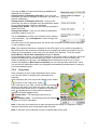
1
User Manual
Further information:
www.falk-outdoor.com
facebook.com/FalkOutdoor
Legal information
United Navigation GmbH
Marco-Polo-Str.1
73760 Ostfildern
United Navigation GmbH reserves the right to amend the details and data provided in this
manual even without any prior notice being given. No part of these documents may be
reproduced or transferred without the explicit written permission of United Navigation GmbH,
irrespective of how or by what means this is done.
All trademarks mentioned in this manual belong exclusively to the respective owners and
may therefore not be used for commercial or other purposes.
As despite all efforts being made errors can never be completely ruled out, no liability is
accepted for the accuracy of the content in this manual. We are grateful to receive
notification about errors at any time.
All illustrations similar to actual product.
© 2014 United Navigation GmbH, Ostfildern.
All rights reserved.
Last revised: March 2014
FMI-11157
Contents
1
2
3
3.1
3.2
3.3
3.4
3.4.1
3.4.2
3.4.3
3.4.4
3.4.5
3.4.6
3.4.7
3.4.8
3.4.9
3.4.10
3.5
3.5.1
3.5.2
3.5.3
3.5.4
3.5.5
3.5.6
3.6
3.7
3.7.1
3.7.2
3.7.3
3.7.4
3.8
3.9
3.9.1
3.9.2
3.9.3
3.9.4
3.9.5
3.9.6
3.9.7
3.10
3.10.1
3.10.2
3.10.3
3.11
3.12
3.13
3.13.1
3.13.2
3.13.3
3.13.4
3.13.5
3.13.6
3.13.7
3.13.8
3.14
3.14.1
3.14.2
3.14.3
3.15
Safety instructions and maintenance.................................................................................... 1
Introduction.............................................................................................................................. 2
Outdoor mode.......................................................................................................................... 3
Navigation view ....................................................................................................................... 3
Main menu ............................................................................................................................... 6
Extras ....................................................................................................................................... 6
Destination entry..................................................................................................................... 6
Address ................................................................................................................................ 6
Home.................................................................................................................................... 7
Travel Guide......................................................................................................................... 7
Points of interest .................................................................................................................. 7
Detailed view of a POI ......................................................................................................... 8
Previous destinations........................................................................................................... 8
Position on map ................................................................................................................... 9
Waypoints ............................................................................................................................ 9
Coordinates........................................................................................................................ 10
Arrange menu .................................................................................................................... 10
Calculated route .................................................................................................................... 11
Alternative routes ............................................................................................................... 11
Altitude profile .................................................................................................................... 11
Route options und drag route ............................................................................................ 12
Route information............................................................................................................... 12
Bus & train (optional) ......................................................................................................... 12
Drag route .......................................................................................................................... 13
Trip computer ........................................................................................................................ 14
Tour planer ............................................................................................................................ 14
Create a new tour............................................................................................................... 14
Plan circuit (optional) ......................................................................................................... 15
Select saved tour ............................................................................................................... 15
Detailed view of a tour ....................................................................................................... 15
Compass ................................................................................................................................ 16
Peakhunter (optional) ........................................................................................................... 17
Hunt peaks ......................................................................................................................... 17
Transfer peaks onto the navigation device ........................................................................ 17
Search peak ....................................................................................................................... 17
Log peak ............................................................................................................................ 18
Create new peak ................................................................................................................ 18
My peakbook...................................................................................................................... 18
Delete created peaks ......................................................................................................... 18
Settings .................................................................................................................................. 19
Navigation settings............................................................................................................. 19
Presentation of the map..................................................................................................... 21
System / General ............................................................................................................... 23
Active route ........................................................................................................................... 29
Remember position............................................................................................................... 29
Geocaching............................................................................................................................ 29
Transfer files to your device............................................................................................... 29
Search for geocaches ........................................................................................................ 30
Arrival at the geocache ...................................................................................................... 33
Delete geocache ................................................................................................................ 33
Logging in the community .................................................................................................. 34
Pocket query ...................................................................................................................... 34
Found geocaches............................................................................................................... 34
Terminology and symbols .................................................................................................. 34
Waypoint manager ................................................................................................................ 36
Choose waypoint................................................................................................................ 36
Create waypoint ................................................................................................................. 36
Delete created waypoints................................................................................................... 36
Track manager....................................................................................................................... 37
3.15.1
3.15.2
3.15.3
3.15.4
3.16
3.16.1
3.16.2
3.16.3
3.16.4
3.17
3.18
3.19
3.19.1
3.19.2
3.19.3
3.19.4
3.20
4
5
5.1
5.2
5.2.1
6
7
8
Track selection ................................................................................................................... 37
Recorded tracks ................................................................................................................. 37
Transferred tracks .............................................................................................................. 38
Detailed view of a track...................................................................................................... 38
Travel Guide .......................................................................................................................... 39
Stipulate a search centre ................................................................................................... 39
Travel Guide theme category............................................................................................. 40
Sorting additional information ............................................................................................ 41
Detailed view of a POI ....................................................................................................... 41
Bus & train transport planner .............................................................................................. 42
GPX manager......................................................................................................................... 43
Map errors.............................................................................................................................. 43
Create map error on the menu........................................................................................... 43
Create map error while travelling ....................................................................................... 44
Create POI error................................................................................................................. 44
Edit map and POI errors .................................................................................................... 44
Help......................................................................................................................................... 44
Tips and tricks ....................................................................................................................... 45
Introduction to the Falk Navi-Manager................................................................................ 46
Import of GPX files................................................................................................................ 46
Transfer of content ............................................................................................................... 48
Import of POIs .................................................................................................................... 48
Troubleshooting .................................................................................................................... 50
Service & support.................................................................................................................. 51
Glossary ................................................................................................................................. 52
1
Safety instructions and maintenance
Safety instructions
The device may only be stored at temperatures of from -20°C - 60°C and be operated at
temperatures of from -10°C – 60°C.
Keep your device away from extreme temperatures. The device should only be operated
and stored in an atmospheric humidity of from 0% to 90%.
Do not expose your device to sudden great fluctuations in temperature. This could result in
condensation collecting in the device, which could damage it. If any condensation forms,
wait until the device has completely dried out.
The device is waterproof in accordance with the IPX7 standard. This means that the device
is also protected against being temporarily submerged.
Caution: To ensure that the device is protected against the ingress of water, the
following aspects must be followed:
Make sure that the rubber cover for the USB port on the bottom of the device is
completely closed.
Also be aware that the housing cover must be correctly locked in place to prevent the
ingress of water.
Note that the device must not be submerged for longer than 30 minutes in a water
depth of 1 metre.
You must not place, store or leave your product in or next to heat sources, at places which
have high temperatures or a high level of solar radiation, in a microwave oven or pressurised
container, and you must also not expose it to any temperatures of over 60ºC (140ºF).
Use only Falk original accessories or Falk-approved adapters. The use of other components
may result in malfunctions and/or serious damage.
Caution:
−
This navigation device for outdoor use is merely an orientation and navigation aid which
cannot be a substitute for making a sensible assessment of the situation you are in.
Please in any event note the particular characteristics of the terrain and the routes you
are using. Do not follow any routes or suggested routes which would entail a dangerous
or illegal form of riding or would place you in a dangerous situation.
−
The road traffic regulations must be complied with at all times, for example when
cycling, and have priority over the routes of the navigation device.
−
Never operate the navigation device while riding and do not allow yourself to be
distracted by the device while riding.
−
Please note that United Navigation GmbH does not accept any liability for any damage
caused by the device/bracket becoming detached from the bicycle.
−
The map data which is used may include inaccurate or incomplete data. You should
therefore check the calculated route to see if it makes sense and choose your own
alternative route if necessary.
−
The navigation device is NOT suitable for use as a vehicle navigation system!
Disposal
DISPOSAL OF USED ELECTRICAL AND ELECTRONIC DEVICES (TO BE
APPLIED IN THE COUNTRIES OF THE EUROPEAN UNION AND OTHER
EUROPEAN COUNTRIES WITH A SEPARATE COLLECTION SYSTEM FOR
THESE DEVICES)
The symbol on the product or its packaging indicates that this product cannot be treated as
normal household waste, but must instead be handed in at a collection point for recycling
electrical and electronic devices. Your contribution to correctly disposing of this product
User Manual
1
helps to protect the environment and the health of your fellow human beings. The
environment and health are endangered by incorrect disposal. Material recycling helps to
reduce the consumption of raw materials. You can obtain further information about recycling
this product from your local authority, the municipal waste disposal companies or the shop in
which you purchased the product.
−
WEEE Reg. No. DE 19715620
Aircraft and hospitals
The use of electronic devices is prohibited in most aircraft, in many hospitals and at lots of
other places. The device must not be used in such environments. Always switch your device
off wherever appropriate requests are made for you to do so.
CE certificates and RoHs
This device complies with the Directives of R&TTE 1999/5/EC and the Directive 2002/95/EC
OF THE EUROPEAN PARLIAMENT AND COUNCIL dated 27 January 2003 on the
restriction of the use of certain hazardous substances in electrical and electronic equipment
(ROHS).
The link to the certificates can be called up here:
http://www.falk-outdoor.com/en/service-en/certificates.html
2
Introduction
This manual describes the functions of the Falk LUX products.
Functions which do not apply to versions of products because they are not included in the
standard scope of supply for the product are marked optional.
The chapters are based around the menu structure of the application. This means you
quickly know where you need to look to find an explanation of a particular function.
If you are still not able to find something, you can search for particular terms in the
Glossary.
The Tips and tricks help you to do what you want and quickly get to grips with your device.
If you have any problems using the device or something seems not to be working, the
Troubleshooting section may be able to help. If this still does not provide you with a
solution, please contact our Service & support team (see chapter 7).
The following elements are used in this manual to make it easier to understand:
Note: Information worth knowing
Tip: Practical application aids
Caution: Warning notice to prevent any undesired effects
Important terms are marked in bold in the text.
All illustrations similar to actual product.
User Manual
2
3
Outdoor mode
3.1
Navigation view
GPS signal: Indicates the status of the GPS reception.
GPS signal is not sufficiently strong to allow positioning. Signals are being received from
fewer than 3 satellites.
GPS signal is sufficiently strong to allow positioning. Signals are being received from 3
satellites.
A high-quality GPS signal is being received that allows your elevation to be determined.
Signals are being received from at least 4 satellites.
GPS status:
The fundamental basis for any navigation is to have sufficient coverage by satellites to allow
your current location to be determined continuously with the aid of a GPS (Global
Positioning System) signal. You can find out how to check the GPS status of your device in
chapter 3.10.3.2.
Note: When the device is first switched on, it may take a few minutes until the GPS position
is recognised. When the device is switched on subsequently, your position will be identified
more quickly.
Means of transport: The symbols
currently selected.
and
tell you which means of transport you have
Track recording symbol: During the recording of a training session, a red dot appears in
the status bar.
User Manual
3
Compass: Indicates the current compass direction.
Battery: The battery symbol shows you the status of the battery.
- Capacity remaining
- Device connected to power source
Info box: Shows information about the calculated route. Tap on the box to select other
information which should be displayed there. For example, you can also display the current
altitude, the time or the gradient.
Map: Shows the map extract with your current position. However, you can also move the
map with your finger. Using the
button, which then appears at the bottom, you can
return the map back to your current position.
Zoom button: Tap on the zoom button
the scale of the map.
and then on the plus or minus symbol to adjust
Next manoeuvre:
In the manoeuvre box you are shown, via an arrow, the next turn-off direction,
other roads which lead off and the distance to your next manoeuvre. If you are on
a roundabout, the other roads which lead off are also shown in addition to your
turn-off arrow.
Relevant crossroads and junctions located before you get to your next turn-off
point are also shown. If there are several crossroads leading off prior to your next
manoeuvre, numbers at the side indicate how many crossroads you still need to
pass.
Note: If you click on the manoeuvre box, the system will tell you what the next turn-off
command is.
If you need to perform several manoeuvres in quick succession, the next-but-one
manoeuvre is shown in the form of a directional arrow above the Manoeuvre box (with a
grey background). This means you can always see where you are heading in good time.
Current street / Coordinates: Here you are shown the street you are currently located on.
When you are on off-road terrain, you are shown the coordinates of your current location.
Main Menu: The main menu button takes you to the menu
guidance screen.
Tip: If on the navigation view you tap on the menu button
for a long time, all of the navigation information is hidden
and only the map is displayed.
Switching to the menu or tapping again for a long time will
take you back to the normal view.
User Manual
4
Altitude profile
The altitude difference to be overcome is important for each
route in order to know how many inclines or descents exist
in which section of the route.
The altitude profile shows this in the form of a graph.
You can view the altitude profile via Active route, or in
.
many other contexts via the button
The route is plotted on the x axis in km (or in miles). On the
y axis the geographical altitude is plotted in m (or in feet).
The marked line indicates the course of the route.
The scale can be altered using the plus and minus buttons.
Tip: Zoom in closer to identify more details in the altitude
profile. If you tap twice on a point on the graph, this point is
zoomed in on.
When you click on a point on the graph, it is marked and the
distance from the starting point is displayed. By clicking on one of the info boxes, different
values which are to be displayed there can be selected.
Current position: Your current position is marked by a red arrow on the map.
Rapid access menu: Offers faster access to specific functions. When you tap on the
symbol, the set functions are shown in the bar at the bottom. You can decide yourself which
functions are displayed there (see chapter 3.10.3.10).
Click on map
If you tap on a point on the map, the point is marked with a
pin and the address or position is displayed. If you then tap
on Actions, you can for example navigate to the marked
point or save the point as a waypoint.
Clickable POIs
With just one click on a POI icon on the map, you can easily
display all the information you need to know about the POIs
which are shown, remember the position, start a radius
search or select the POI for route calculation.
Select a POI icon on the map about which you would like to
know more information.
If you tap on the name of the POI, you will be shown the
detailed view for this POI.
An Actions button appears below the name.
Tap on it. The actions mentioned above are now available to you.
Tap on Close in the info box or on the red arrow at the bottom edge of the screen to switch
back to the map view.
Further information:
If you accidentally miss a turn-off or turn into a wrong street, a new route is automatically
calculated. You will be guided safely by means of voice announcements and the display of
your position, as well as the route to be covered, to your desired destination.
You are automatically in Position Tracking mode if you are not navigating to any destination
or are not in simulation mode. Even if you are not navigating to a specific destination and
simply want to explore the area, you can have your current position displayed continuously
via the navigation screen. You end a navigation or simulation on the main menu by tapping
on the Delete route button.
User Manual
5
3.2
Main menu
You can put the main menu together yourself as you wish by tapping on Settings >
System/General > Main menu functions and by activating the functions you want from the
list (see chapter 3.10.3.12).
The main menu gives you access to these activated functions which are explained one after
the other in the following chapters. To switch from the map view to the main menu, tap on
. To then return to the map view, tap on Map.
3.3
Extras
Functions which you have disabled for the main menu by tapping on Settings >
System / General > Main menu functions are listed under the menu item Extras.
These functions are also explained in the following chapters.
3.4
Destination entry
On the destination entry screen, you have the option of entering any destination you
want in order to be navigated to it. Various possibilities for doing this are available
to you and they are explained one after the other below.
3.4.1
Address
Here you can navigate to a destination by entering
an address. You can enter a full address with the
street and street number.
To enter an address, carry out the following steps:
First tap in the main menu on Destination entry and then
on Address.
You can now enter the city name first or enter a postcode
(not with Basic Map Plus (OSM).
by tapping on
Tap on Next to enter the street and street number.
You can also tap on the city name or street name in the text
box to confirm the entry.
Choose a country
If you tap on the country flag in the upper section of the
screen, you can select the destination country.
Note: You can only enter a destination if a country map which corresponds to the
destination country is installed on your navigation device.
Caution: Depending on the product type, not all detailed maps which are provided are
preinstalled on the navigation device. You can transfer additional country maps to your
navigation device using the PC program Falk Navi-Manager.
You can acquire the latest country maps on the internet via the Falk Online Shop.
Note: For calculation of a route which passes through different countries, you definitely
require the country map for the destination country and the countries which you need to
pass through to get there. If you do not have all of the country maps situated in between, the
European long-distance road network must be installed so that you can get to your
destination country.
User Manual
6
Note: If you do not wish to further restrict your search by selecting a street and / or street
number and simply want to navigate to the centre of the destination city, simply tap on
Centre after selecting the city with Next. If you just want to navigate to a street without a
street number, tap after entering the street on Street Centre.
The
button allows you to view the destination on the map in advance.
If you tap on the country flag in the upper section of the screen, you can select the
destination country (if you have also installed other country maps).
To enter umlauts or special characters, press on the corresponding basic letter for a long
time.
Once you have entered a letter, all of the letters which are no longer possible will be blanked
out.
If you tap on
3.4.2
, a list containing all possible city names for your entry will be displayed.
Home
The Home function takes you back home without any bother at any time.
When you first start the device, you will be asked to enter your home address.
After you have entered your address once, it is saved and you can navigate there at
any time by tapping on Home once. The route from your current position to your home is
calculated immediately.
You can change the saved address in the settings menu at any time.
3.4.3
Travel Guide
The Travel Guide offers you the possibility of searching for POIs in a targeted
manner. In doing this, it makes use of Marco Polo Travel Guide content which has
been researched by editorial teams.
First you must stipulate the search centre.
This can be a waypoint, the current position, the current destination, a city, your home
address, coordinates or the last Travel Guide (if you have already used the Travel Guide
previously).
The POIs are then sorted around this search centre.
3.4.4
Points of interest
Your device contains countless points of interest
such as restaurants, viewing points, natural
monuments, places to stay, places to visit and lots
more.
If you select Points of interest on the destination entry
screen, a list containing all categories appears. You can
select individual categories by tapping on them or select all
categories at once by tapping on All (top right).
Tap on Next (or on
if you want to search for a name of
a category).
Next you must specify a search centre for your search. The
POIs will then be displayed sorted according to their
distance from this point.
The search centre can be a waypoint, your current location,
the current destination, along the route, a city, an address,
a position on the map or coordinates.
User Manual
7
The results are then displayed in a list.
You then have the following options:
Sort - Here you can sort the POIs according to various criteria.
Map - Displays the selected POI on the map.
Calculate - Starts the route calculation to the selected POI.
Double click - Opens the detailed view for a POI.
- Allows you to search for a POI by entering text.
3.4.5
Detailed view of a POI
In the detailed view you will find all of the available
information about a POI.
At the top you can switch between the Info, Map, Picture
(optional) and Options screens by tapping on the tabs.
Info shows you the address, the distance and a descriptive
text.
Map shows you the POI on the map view.
Via Picture you can view a picture of the selected POI if
one exists.
In the Options you also have the following possibilities:
Search for POI around POI - Searches for another POI
around the current one (if for example you would like to find
a restaurant near to the hostel where you are staying).
Enter rating - Possibility of rating the POI. The rating is
then displayed at the top in the detailed view.
Save POI as waypoint - Adds the POI to your own
waypoints.
Report error - Adds a POI error to the map errors.
You can use the two arrows at the bottom to scroll to the
next or previous POI from the list.
Calculate starts the route calculation to this POI.
Back switches back to the list of POIs.
3.4.6
Previous destinations
This function allows you to select the previous destinations that you entered very
easily.
The previous forty destinations are automatically saved.
User Manual
8
3.4.7
Position on map
Here you can mark a point on the map in order to
navigate there. You can also move the map here
using your finger.
If a point which is located in a city or on a street is marked,
the address for this point is displayed. Otherwise the
geocoordinates are displayed.
Tip: Zoom out via the "minus" button so that you can move
the map to the correct point more quickly.
3.4.8
Waypoints
A waypoint is a position or address which has been saved. You can create
waypoints yourself (see chapter 3.14.2) so that you can then navigate to the point
again at a later date.
Here you can now select a destination from the waypoints
which are located on your device. These may be waypoints
you have created yourself or imported waypoints.
To do this, a search centre must first be stipulated.
The waypoints are then displayed sorted according to their
distance from this point.
The search centre can be your current location, the current
destination, along the route, a city, an address, a position
on the map or coordinates.
As an alternative to a search centre, you can also tap on
Show all waypoints, all waypoints will then be displayed
sorted in alphabetical order.
The results are then displayed in a list.
You now have the following options:
Sort - The waypoints can be sorted in alphabetical order or by distance.
Map - Displays the currently selected waypoint on the map.
Calculate - Starts the route calculation to the selected waypoint.
Double click - Opens the detailed view for a waypoint.
The further functions in relation to waypoints are explained in chapter 3.14.
User Manual
9
3.4.9
Coordinates
You can also enter your destination via coordinates.
This function is particularly helpful for reaching a precise location in open terrain where it is
not possible to specify an address.
You can also use the entry of the coordinates for geocaching.
Note: The entry format is important here as there are
different formats for coordinates.
The preset format is based on the pattern of
degrees/decimal minutes (dd°mm.mmmm´).
To set a different format, tap on Format on the right.
A list containing possible formats will then be displayed.
You can change the format again at any time in the settings
(see chapter 3.10.3.7)
With the degrees/decimal format, the degree of latitude is
entered first.
To do this, tap on the right on N for north (north means
north of the equator). Now enter the coordinates.
If you tap on Next, you can enter the degree of longitude.
To do this, tap on E for east (east means east of the prime
meridian).
If you click on Location, the coordinates of the current position are entered.
Note: As Central Europe is situated north of the equator and east of the zero meridian, you
will always use the north/east combination when entering coordinates in this format.
If after entering the degree of longitude you tap on Next, it is (if possible) specified which
address is located close to the coordinates.
Tap on Map to display the point on the map or on Calculate to start routing to this location.
3.4.10 Arrange menu
Here you can change the order of the functions as you wish within the destination
entry screen.
Select a function and move it to the place you want with the aid of the rectangular
arrows.
Do not worry - no function will be lost. And even if the functions become mixed up, you can
tap on Restore to restore them to the preset order.
User Manual
10
3.5
Calculated route
Once you have entered a destination, the route options are
then enquired about. If a route has then been calculated,
you have the option of calling up different information about
the route or calculating alternative routes.
- Calculates two alternative routes.
- Displays the altitude profile for the calculated route.
If you have already calculated alternative routes, here you
can view and compare the altitude profiles for all routes.
- Here you can set the route options again if
necessary
or drag the route
(see chapter 3.5.6).
- Displays the route information with a description for the route in a list.
Note: The alternatives are also calculated by taking account of the route options entered
previously.
You can start routing via Navigation.
3.5.1
Alternative routes
If after calculating a route you have calculated alternative
routes, they are shown in different colours on the map.
You can then select an alternative via the boxes at the
bottom which are also marked in the relevant colour.
You can then view the different information for the selected
alternative.
3.5.2
Altitude profile
You can compare the altitude profiles for all alternatives if you tap on
.
The route is plotted on the x axis in km (or in miles). On the y axis the geographical altitude
is plotted in m (or in feet). The scale can be altered using the plus and minus buttons.
Tip: Zoom in closer to identify more details in the altitude profile. If you tap twice on a point
on the graph, this point is zoomed in on.
When you click on a point on the graph, it is marked and the distance from the starting point
is displayed. By clicking on one of the info boxes, different values which are to be displayed
there can be selected.
User Manual
11
If you have already calculated alternative routes, here you
can view and compare the altitude profiles for all routes
The altitude profiles are marked in the same colour as the
route in each case.
You can switch between the altitude profiles using the
arrows at the bottom.
3.5.3
Route options und drag route
To change the route options which are set for the calculated route, tap on Route options.
When you change the route options, the route is recalculated. You will find more information
about the Route options in chapter 3.10.1.1.
You will find more information about the Drag route function in chapter 3.5.6.
3.5.4
Route information
You can call up the route information by tapping on
.
Here you can call up the route information and display the
description of the route in the form of a list.
The following information is displayed to you in the Route
description:
−
The name of the respective road.
−
The route which is being covered on the respective
road.
−
With major roads or motorways, the abbreviation (e.g.
B311).
−
The destination is shown on a bar at the bottom.
The Display button allows you to view the selected entry on
the map and scroll through the route.
3.5.5
Bus & train (optional)
The Bus & train function allows you to incorporate public transport into the route calculation.
The stops or stations which are located closest to the starting point and destination point of
the route are selected here. The routing runs to the starting station and from the destination
station to the final destination. The route calculation includes the approximate travel times
for the means of public transport which are used.
After calculating the route, tap on Public transport.
A list appears containing the start, the entry and exit points for the public transport and the
destination.
User Manual
12
If you tap on Edit, you have the following possibilities for
adjusting the connection:
Change means of transport from start – here you can
select how you want to navigate to the station you start from
(bicycle, pedestrian)
Change means of transport from exit – here you can
select how you want to navigate from the destination station
to your final destination (bicycle, pedestrian)
Change entry station – here you can select an alternative
station from a list
Change exit station – here you can select an alternative
destination station from a list
Tap on Calculate to confirm your selection and to start the
route calculation. Tap on Navigation to start routing to the
starting station.
Once you arrive at the starting station, the bus & train connection is automatically displayed
on the navigation screen.
Note: The automatic switchover depends on the GPS signal. As it is often not possible for
the GPS signal to be received in buildings and in underground stations, the device may not
switch over automatically. In this case, you can switch over manually. To do this, select
Active Route > Bus & train connection and tap on Get on.
On the navigation screen, you can while travelling on the public means of transport move the
list which is displayed up or down with your finger. If you tap on an entry in the list, the
station is displayed on the map. The Position button restores the map to your current
position. By tapping on Bus & train connection you can view the entire connection. Once
you arrive at the destination station, the navigation automatically switches back to routing to
your final destination point.
3.5.6
Drag route
After calculating a route via the destination entry screen,
you have the option of modifying the calculated route
manually.
After calculating the route, tap on the "Modify route" button
and then on the "Drag route" button
.
If you now tap on your route, you will be given a marking
which you can drag to any point you want on the map. The
new route is then shown to you. Furthermore, the original
point is displayed to you along with two buttons to
continue using the dragged route.
Delete point – The marking set previously is
cancelled.
Set another point – The marking just set is adopted
and the new route is calculated.
Note: If the point is set away from a road, the nearest point linking to a segment of road is
searched for and the route is calculated using this point.
Note: A set point can be selected, moved or deleted again at any time.
User Manual
13
3.6
Trip computer
The Trip computer provides you with lots of data
and figures while you are on the move.
When you tap on Trip computer, six preset figures
are shown to you.
However, lots of other figures can also be displayed.
To do this, tap on one of the boxes displayed. You can then
select from a list of all the available data which figure you
would like to have displayed in this box.
The destination is displayed in the box at the bottom.
Note: The trip computer can only be reset via the Reset
button.
This means that figures in relation to day trips or trips over
several days can be collected. Even switching off the device
does not reset the trip computer.
The trip computer is reset for the duration of a track recording so that only the values for the
track are displayed. Once the track is ended, the values for the track are added to the trip
computer values which were displayed previously.
3.7
Tour planer
Tours are routes which contain several destinations one after the other. You can
compile your own tours on the device. You can use all sorts of destinations to do
this.
3.7.1
Create a new tour
Via Plan tour you can compile a tour for yourself.
The preset starting point is your current location.
To change this, simply click on the Start button. You then
have several options for entering a starting point (e.g.
address, previous destinations etc.)
You can then also enter the destination point in the same
way.
When you tap on Calculate, the route is calculated and
displayed on the map.
In addition to the functions
for the calculated route
from the normal destination
entry, you can also simulate
the calculated route here (not where there are several
stations).
The route is run through virtually here. You will see on the
map how the route proceeds and when and how turns are
made. To do this, tap after calculation on Demo.
For routes with several stations, you can add destinations to
the tour by tapping on the Add further destinations button
and then + Add station.
All kinds of destinations can be used as stations. The
User Manual
14
different kinds of destinations are entered in the same way as with normal destination entry.
Once you have entered all destinations, tap on Calculate. You will then be asked to save
the route under a name which you are free to choose. When you confirm the name, the tour
is created. You can start the routing by tapping on Start tour. You can choose whether the
route calculation should start from your current position or the first station.
3.7.2
Plan circuit (optional)
Tap in the Tour planner on Plan circuit. Here you can start
a circuit from a stipulated starting address. Here too, the
preset starting point is your current location.
After entering the address, you can specify either the
required distance or the duration of the circuit. The Falk
Navigator then calculates a circuit which reflects the route
options that have been set and takes you back to your
starting point.
Note: In order for example to obtain a version of the circuit
with less of an altitude gain, you can vary the entry by a
minimal amount (e.g. around 1 km).
3.7.3
Select saved tour
If you have already created tours, you can call up a tour via
Select saved tour.
First select whether the tours should be displayed sorted around your current location or an
address. Or you can simply have all tours displayed. They are then listed in alphabetical
order.
Select the tour you want from the list and tap on View tour.
The detailed view of the tour is then displayed.
Via Edit you can change the settings for the tour.
If you tap on Start tour, you start the routing. You can select whether the route calculation
should start from your current position or the first station.
3.7.4
Detailed view of a tour
You will find all of the information you need about a tour in
the detailed view.
First select a tour and tap on View.
You can switch between three views using the tabs at the
top:
Info: Shows the starting point and destination point, as well
as the route length and the number of stops.
Map: Shows the tour on the map.
Stations: Displays a list of the individual stations.
In the station list you can also deselect certain destinations
on the tour if you do not want to navigate to them. To do
.
this, tap at the end of the line for the station on
means that the station will be ignored.
means that the station will be navigated to.
means that the station has already been visited (on the current tour).
User Manual
15
When you tap on Start tour, the tour is started.
To make further settings in relation to the tour, tap on Edit.
3.7.4.1
Edit tour
To edit a tour, first select a tour and then tap on View.
Now tap on Edit.
The following setting options are then available to you:
– Here it is possible to add further
Edit stations
stations, change the sequence of the stations and delete
stations again.
Set direction of travel
– Here you can reverse the
tour. The stations will then be navigated to in reverse order.
Edit name
– Here you can edit the name of the tour.
Delete tour
– Here the selected tour can be deleted.
3.8
Compass
After calculating a route to a geocache or to a peak or during navigation, you can
use the Compass menu item to display various pieces of information.
Display of static route information:
−
Arrow which points towards the destination, the
geocache or the peak
−
Distance to the destination, geocache or peak
−
Direction towards destination, geocache or peak
−
Name or coordinates of the destination, geocache or
peak
Display of variable route information via the route
information buttons:
−
e.g. the geocoordinates of your current position
−
e.g. the geocoordinates of the destination, geocache or
peak
−
e.g. the GPS accuracy
If the destination is a geocache, when you reach the
destination you receive a message and an Actions button.
If the destination is a Peakhunter peak, when you reach the destination a message and a
Log button is displayed.
Note: If the compass needs to be calibrated, a Please calibrate button is displayed. Please
follow the instructions for compass calibration.
User Manual
16
3.9
Peakhunter (optional)
3.9.1
Hunt peaks
Peakhunter is a kind of virtual peak guestbook in which you can make an entry when
you reach a peak. Furthermore, you can navigate to the peaks which are already
preinstalled or create new peaks.
3.9.2
Transfer peaks onto the navigation device
Peaks are already preinstalled on your Falk navigation device and you can utilise the
Peakhunter function immediately.
However, if you want to download further data onto your device, you can transfer the GPX
file by means of web plugin directly onto the navigation device.
To do this, you log in on the Peakhunter homepage (http://www.peakhunter.com) and
navigate to the Falk Outdoor Navigation page.
First of all, you should choose the desired country whose peaks you want to download and
then install the Falk Device Plugin.
Once the Falk Device Plugin has been installed, you can select the navigation device which
is connected to the PC. Finally, tap on the Transfer data button to transfer the data to your
device.
3.9.3
Search peak
If you want to navigate to a peak, tap on Peakhunter and
then on Search peak. Then specify the search centre you
want. You can use your Around location, enter an address
(Around address) or specify coordinates (Around
coordinates). The peaks are then sorted and displayed
according to their distance from this centre.
Once you have selected a peak from the list, you can
display the peak on the map by clicking on Map, navigate to
it directly by clicking on Calculate or call up the detailed
view by double-clicking on the list entry.
3.9.3.1
List of peaks
In the list view, you are shown all peaks in the area
surrounding your search centre, sorted by distance. Logged
peaks have a green circle with a white arrow, created peaks
are symbolised by a pencil.
Here you can also search for peak names. To do this, start
the search with ABC and enter the name you want.
Furthermore, you can sort the list of peaks according to
specific criteria. Tap on the Sort button and choose from the
various sorting possibilities:
Distance: The list of results is sorted by distance from your
search centre as standard.
Alphabetical: The list of peaks is sorted in alphabetical
order.
User Manual
17
3.9.3.2
Detailed view of a peak
In the detailed view, you will find all of the available information about a peak.
By tapping on the tabs you can switch between the Info, Map and Options views.
On the Info tab, you can tell from a green circle with a white arrow that you have already
logged the peak. Furthermore, for example, you are shown the geocoordinates of the peak,
the height of the peak, the distance from your search centre and the cardinal direction from
your search centre.
The Map tab shows you the peak on the map view.
In the Options, you also have the following options:
Log peak - Here an entry can be made in the virtual
peakbook or existing entries can be viewed. In addition, a
comment can be added or corrected or be deleted if
necessary.
Search for POI around peak - Searches for a POI around
the selected peak.
Save peak as waypoint - Adds the peak to your own
waypoints.
Using the two arrows at the bottom, you can scroll to the
next or previous peak in the list.
Calculate starts the calculation of a route to this peak.
Back switches back to the list of peaks.
3.9.4
Log peak
A peak can only be logged if you are within a distance of no more than 50 m from the peak.
If you have been navigated to the peak, when you reach your destination a Log button
appears on the navigation screen. If you have arrived at the peak without being navigated
there, you can also log the peak via Peakhunter > Log peak.
3.9.4.1
Correct the position of a peak
If you are within a distance of from 50 m to 200 m of a peak, the position of this peak can be
corrected.
3.9.5
Create new peak
If you have climbed a peak which has not yet been recorded via Peakhunter, you can create
this here yourself.
In a first step, you give the peak a name, then tap on Next and in a second step you specify
the peak height. The peakbook entry for the newly recorded peak will then be shown to you.
Here you also have the option of entering a comment.
3.9.6
My peakbook
In your peakbook you will find a list of your created and logged peaks (see chapter 3.9.3.1).
Logged peaks have a green circle with a white arrow, created peaks are symbolised by a
pencil.
3.9.7
Delete created peaks
All peaks which you have created can be deleted here.
User Manual
18
3.10
Settings
The settings for your device are subdivided into three categories.
The navigation settings relate to the routing, the map display comprises all functions
of the map and the system / general settings relate to the device or the application as
a whole.
3.10.1
Navigation settings
Here you can make various settings relating to the routing. To do this, click in the
menu on Settings > Navigation Settings.
The following options can be changed:
3.10.1.1 Route options
The route options allow you to define your own individual route.
The route options include three settings: the means of transport, the route
optimisation and the type of routes. These settings are run through as standard after
each route calculation.
When it comes to the means of transport, you can choose bicycle
and pedestrian
.
Route optimisation
With the route optimisation, you have various options for adapting the route:
Flat
- The route preferably runs over flat sections.
Mountainous
Short
- The route preferably runs over hilly sections.
- Calculates the shortest route to the destination, regardless of inclines.
– Plots a straight line from your current location to the destination
Linear distance
(bearing navigation).
Note: The selected route optimisation also has an impact on the length of the route. For
example, if you choose Flat sections of the route with an incline that is too steep will be
avoided, which can result in a longer route.
With the Transport routes, you have the following options:
Cycle paths
- Use or avoids cycle paths (only in bicycle mode).
- Use or avoids hiking trails (only in bicycle mode) / use or prefer hiking
Hiking trails
trails (only in pedestrian mode).
Steep gradient
Road traffic
Turns
– Use or avoids gradients of over 8% (only in bicycle mode).
– Use or avoids road traffic (only in bicycle mode).
- Use or avoid many turn manoeuvres (only in bicycle mode).
Ferries
- Use or avoid routes involving ferry connections.
Tunnels
- Use or avoid routes that pass through tunnels.
Fixed rope routes
Paths
User Manual
- Use or avoid fixed rope routes (only in pedestrian mode).
- Use or avoid routes via paths and dirt tracks.
19
To avoid one of the options, tap on the corresponding symbol. Symbols with a red "X" mean
that the corresponding type of route will be avoided. Symbols with a heart mean that
preference is given to this type of route.
Note: "Avoid" does not mean that these types of routes are completely ruled out. It is always
possible that avoided types of routes will also be used in individual cases.
3.10.1.2 Set routing
Here you can set whether you want to be guided during
navigation by voice output or by a beeping noise. The voice
output issues spoken turn-off instructions with indications of
distance. The beeping noise output warns you with a beep
when you are approaching a turn-off or when you deviate
from the calculated route.
3.10.1.3 Stipulate country map
Only one country map can be used for a country at any one time. If you have installed
several country maps for a country on your device (e.g. Basic Map Plus Germany and
Premium Outdoor Map Germany - partial coverage), you can set the priority of the map to be
used. This will then be used both for the map display and in the address entry.
To do this, proceed as follows:
Tap in the country selection list on the map which is
currently inactive (grey background) for a country.
The map priority prompt now appears. You then have the
following possible options:
- Always prefer Premium Outdoor Map: Stipulates that (if
available) the Premium Outdoor Map is always used
(recommended setting if you are travelling in a territory for
which you have a Premium Outdoor Map (e.g. southern
Germany) if you have the Trans-Alp Premium Outdoor
Map).
- Prefer Basic Map Plus (OSM) for the maps for which only
part of a Premium Map is available (e.g. southern
Germany): Stipulates that preference is given to the Basic
Maps even if a Premium Outdoor Map is available for part of
the country.
This setting is recommended if you have installed the Trans-Alp Premium Outdoor Map and
want to calculate a route which no longer lies fully within the area covered by the map with
partial coverage (e.g. southern Germany). In this case, the Basic Map Plus (OSM) is used
for the corresponding country, if available.
Example: You are planning a tour with several stops from Frankfurt to Florence. You have
installed the Trans-Alp Premium Outdoor Map and the Basic Maps Plus (OSM) for Germany,
Austria and Italy. With the setting described above, you can now navigate from Frankfurt on
User Manual
20
the Basic Map Plus Germany as far as the Austrian border. As the Trans-Alp Premium
Outdoor Map also covers the whole of Austria, you will continue to be routed all the way
through Austria on this map. In Italy, you will then be routed on the Basic Map Plus Italy as
the destination (Florence) is no longer covered by the Trans-Alp Premium Outdoor Map.
- Always prefer Basic Map Plus (OSM): Stipulates that the Basic Map is always used even if
a Premium Outdoor Map is available for this country or part of this country.
3.10.1.4 Speed profile
This function allows you to set your average speed.
The set profile helps to calculate the arrival time
and total travel time more exactly.
You can set this setting separately for pedestrian and
bicycle mode. You can choose between different speed
settings in each case. Set your desired profile using the
plus/minus buttons and confirm it with Ok.
3.10.1.5 Ask about route options
If this function is activated, the route options are asked about before each route calculation.
This function is activated as standard. If you do not frequently change the route options,
disable this function.
3.10.2
Presentation of the map
Here you can make various settings which affect the map view. To do this, click in the menu
on Settings > Presentation of the map.
The following options can be changed:
3.10.2.1 Map perspective
/
With the map perspective you can switch between the two-dimensional and
three-dimensional representation of the map. The respective setting is indicated by the
symbol and the text 2D or 3D.
3.10.2.2 2D Raster maps (optional)
/
With the raster maps you can view landscapes and cities from a bird's-eye
perspective via topographic maps. The raster map thus makes it easy for you to get your
bearings.
Requirement: You have activated the 2D map view and installed raster maps.
3.10.2.3 2D Relief map (optional)
/
With the relief maps you see a vivid three-dimensional representation of the
terrain.
User Manual
21
3.10.2.4 In direction of movement / Orientated
/
the north.
The map can be orientated either in the direction of movement or always to
Note: If you select In direction of movement, the positional arrow always points upwards.
This setting facilitates orientation. If you select Orientated, the positional arrow is located in
the middle of the map and rotates according to the direction of movement.
3.10.2.5 Position on street
/
Here you can stipulate whether your current position should be mapped
onto the route network.
Note: For geocaching and for navigation on open terrain, it is essential that you switch off
this function.
3.10.2.6 City name on basic map
/
If you do not have maps for a continent or country, this function still allows
you to display the city names on the basic map to allow better orientation.
If you then subsequently go on to purchase more maps, you can deactivate the labelling on
the basic map here.
3.10.2.7 Auto zoom (only in bicycle mode)
/
When auto zoom is activated, the scale of the map is adjusted on the basis
of your speed (at high speed the map zooms out). If you switch off the auto zoom, you can
set the scale of the map on the map view screen yourself. This is then retained.
3.10.2.8 POIs on map
Here you can choose which points of interest should be displayed with small
symbols on the map. To do this, select the categories you want. All points of
interest in the chosen categories will then be displayed on the map.
3.10.2.9 Track recording on map
/
For the track recording (see chapter 3.15.2.1) you can set here whether the
route covered should be shown on the map view.
Note: This setting only relates to the map view during recording. With a saved track, the
route covered can always be displayed on the map at a later date.
3.10.2.10
Set map colours
You can use the Set map colours button to adjust the colours used on the map
display. With the arrows you can switch back and forth between the colours. When
you tap on Ok, the selected colour will be used.
User Manual
22
3.10.2.11
Show building outlines (optional)
/
To make things clearer, you can have the schematic outlines of buildings
displayed on the grid map in populated areas.
3.10.2.12
Arrange menu
Here you can change the order of the functions as you wish within the destination
entry screen.
Select a function and move it to the place you want with the aid of the rectangular
arrows.
Do not worry - no function will be lost. And even if the functions become mixed up, you can
tap on Restore to restore them to the preset order.
3.10.3
System / General
Here you can make various settings which affect the device. To do this, click on the
menu on Settings > System / General.
The following options can be changed:
3.10.3.1 Battery
The battery option allows you to check the
remaining battery capacity.
When connected to a power source, Charging is
displayed above the capacity meter.
In the case of a device for standard batteries (optional),
here you can change the battery type to optimise the
display of the remaining battery capacity. To do this, choose
the relevant battery type (alkaline, lithium or NiMH) and
confirm your entry with Ok.
3.10.3.2 GPS-Info
GPS Info indicates the GPS reception signal strength at the current location.
Adequate GPS reception is essential for any navigation.
An info page with information about the existing GPS connection and your current
position as well as the altitude and speed is displayed.
The colouring provides you with information about the GPS status at a quick glance:
−
Red: GPS signal is not sufficiently strong to allow positioning. Signals are being
received from fewer than 3 satellites.
−
Yellow: GPS signal is sufficiently strong to allow positioning, but not sufficiently strong
to allow the current elevation to be determined. Signals are being received from 3
satellites.
−
Green: A high-quality GPS signal is being received that allows your elevation to be
determined. Signals are being received from at least 4 satellites.
User Manual
23
3.10.3.3 Brightness
Here you can set the brightness of the screen.
The brightness settings have a great influence on
the power consumption of your navigation device. To save
power in battery mode, turn down the brightness level.
In addition, you can select whether the screen should
automatically be dimmed when the battery is weak in order
to save power.
Confirm your setting by tapping on Ok.
3.10.3.4 Volume
The volume option allows you to change the volume of your navigation device or
switch it off entirely. Optionally, you can if necessary also make a separate volume
adjustment for individual functions in the Falk Navigator.
To change the system volume or switch it off entirely, first tap on the Volume button. You
can increase the volume by tapping on the plus symbol or reduce the volume by tapping on
the minus symbol. The volume which is set is indicated to you as a ratio of the maximum
volume.
However, you also have the option of switching off the sound with one click. If you tap on
Sound at the bottom, the sound is muted. When you want to cancel the muting again, click
on Sound again or on the plus or minus symbol.
Confirm your selection with Ok or exit the display with Cancel.
Under Advanced you can make separate settings in
relation to the volume of the speakers and the system key
tones.
Tap on Ok to save the settings.
Note: The advanced volume settings are always dependent
on the system volume. A change to the system volume
therefore also always results in an adjustment to the volume
in the individual functions of your Falk Navigator.
User Manual
24
3.10.3.5 Calibrate compass
To guarantee precise orientation of the compass,
you should recalibrate the compass at regular
intervals. To do this, tap on Calibrate compass and
follow the instructions on the device.
Note: You should only ever calibrate the compass outdoors.
Make sure when calibrating it that no metallic objects are
located in the vicinity of the device and that no magnetic or
electro-magnetic sources of disturbance (e.g. high-voltage
power lines, antennae) are present.
3.10.3.6 Calibrate barometer
To optimise the accuracy of the height measurement, you should calibrate the barometer at
regular intervals.
You can calibrate the barometer in three ways:
−
Automatic - The barometer is then calibrated
completely automatically. (However, to obtain more
accurate results it is recommended that you calibrate it
manually.)
−
Manual by specifying height - If you know the height
of your current position, enter this and place the device
down to rest on a flat surface for a short time.
−
Standard atmospheric pressure - Then the standard
atmospheric pressure at sea level is used to determine
the height.
Note: The barometer should be calibrated after each
change of battery. In changeable weather and where there
are large differences in height, it is recommended that you
calibrate the barometer several times a day.
3.10.3.7 Set position format
There are different formats for specifying
coordinates. To support the entry of the most
common formats, here you can select the format you
want.
The following formats are available to you:
−
dd.ddddd°
(decimal degrees)
−
dd°mm.mmmm` (decimal degrees and minutes)
−
dd°mm`ss.ss"
(decimal degrees, minutes,
seconds)
−
Gauß-Krüger
(easting, northing)
−
Swiss grid
(longitude, latitude)
−
UTM
(zone, easting, northing)
This setting is then used in the entire system.
Note: UTM and Gauß-Krüger are formats from printed
maps. You can read the coordinates off such maps and enter them in the device.
User Manual
25
3.10.3.8 Screen auto-off
You can use this function to set whether and after
what period of time the screen automatically
switches off. You can choose between never, 15 seconds,
30 seconds 1 minute. In addition, you can select whether
the keylock should also be activated at the same time so
that no accidental entries are made.
Note: While your screen is switched off, existing navigation
operations or track recordings continue to run. If you press
the hardware key (when the keylock is active) or click on the
screen, the screen is activated again. Announcements
continue to be output. This function helps you to extend the
life of the battery.
3.10.3.9 Set home
The Set home option allows you to change your home address which you entered
when you first started the device.
Tap on Set home.
You can enter your home address via the on-screen keypad.
Confirm your entry with Ok.
The display automatically switches back to the settings menu.
The address which is entered can be overwritten at any time by entering a new address.
3.10.3.10
Rapid access menu
Adapt the rapid access menu on the navigation
screen to reflect your individual needs by
stipulating which functions and settings of the Falk
Navigator you want to have rapid access to.
Tap on Rapid Access Menu and then on the function
which you would like to change in the rapid access menu
view.
Select a function or setting from the list.
You can scroll through the list using the arrow buttons. You
can use the
kannst Du über die Namenseingabe nach
einer Funktion suchen.
button to search for a function by entering a name.
Confirm with Ok.
Reset allows you to restore the original setting.
3.10.3.11
Hardware button setting (optional)
Here you can stipulate which function can be controlled via the control button. Select
one of the specified functions from the list and confirm with Ok.
User Manual
26
3.10.3.12
Main menu functions
You can put the main menu together yourself as you
wish by activating the functions you want from the
list.
Disabled functions are not checked, slip to the end of the list
and can then be found in the Extras menu.
3.10.3.13
Kilometres / Miles
Tap on Kilometres or Miles to determine the unit of measurement for specifying
distances. You can switch between kilometres and miles. The speed data is then
also specified in the selected format.
3.10.3.14
Default settings
If you tap on Default settings, you can reset the settings of the Falk Navigator to
the factory settings; the navigation device is automatically restarted when you do
this. You then have the option via the start wizard of making new settings.
3.10.3.15
Time
The Time option allows you to set the time zone
and the time format.
Note: The current date and the current time are received
with the GPS signal and are thus always set to the nearest
second.
To set the time zone in which you are situated, tap on the
left or right arrow in the top section of the screen.
An automatic switchover between winter and summer time
is preset. If you would prefer to set the summer time
manually, select On. If Off is activated, winter time is
displayed.
Confirm the settings with Ok or exit the display without
saving the settings via the Cancel button.
User Manual
27
3.10.3.16
Language
Tap on Language to select the menu language
and a speaker. First select the language in which you want
to be guided through the menus in the Falk Navigator. The
language is always specified in the respective national
language.
If several speakers are preinstalled in a language on your
device, select the speaker you want. Confirm your selection
with Ok.
3.10.3.17
Screen
If the screen no longer reacts to being tapped on without any errors, it needs to be
recalibrated. To do so, you need a stylus (optional) or another blunt object. To avoid
damaging the display, never tap it with any pointed object.
Choose the Screen option and start calibration by confirming the following display screen
with Ok. If you do not want to carry out the calibration, exit the display by tapping on Cancel.
Tap and hold the stylus for a short while on the cross. Repeat the process for each position
at which the cross is located.
The calibration process is complete as soon as there is no longer any cross displayed. Tap
on the screen again to return to the menu.
3.10.3.18
Info about
You can use the Info about option to display system information, in particular about
the version of the navigation software used, about the map material and map data
used. The Extra functions button gives you an overview of the software functions
available to you for a limited period of time.
To exit the display, tap on Back.
Tap on the Copyrights button to display information about copyrights for the software used.
Here you will also find country-specific copyright notices.
3.10.3.19
Arrange menu
This function allows you to determine your own personal menu order in order to be
able to access the functions which are important to you quickly and with ease.
With the arrow keys on the left you can scroll through the list. Select the function whose
position you would like to change by tapping on it. With the angular arrows on the right you
can move the previously selected function to another point on the list. Confirm your entry by
tapping on Ok. You can use the Restore button to restore the standard order.
User Manual
28
3.11
Active route
If you have calculated a route and are in navigation mode, you have the following
options under Active route:
−
−
−
−
−
−
−
−
Calculate alternative - Calculates two alternative routes.
Avoid route ahead (optional) - Here you can avoid part of the route located directly
ahead of you if, for example, there is a set of roadworks there and it is not possible to
travel any further. To do this, select the length of the section of the route which is to be
avoided and tap on Ok.
Enter stopover - Here you can enter a stop-off point which is then navigated to before
the destination which has already been entered.
Next destination - If you have entered a stop-off point or are on a tour, you can
navigate to the next destination here.
Current tour profile - If you are travelling along a tour, you can view the entire tour
profile here.
Active geocache - If you are looking for a geocache, you can view the detailed view of
the current geocache here.
Calculate shortcut - If you have calculated a circuit, you can use this to calculate the
shortest route or a direct route to the destination.
Bus & train connection (optional) - If you have calculated a bus & train connection,
you can view the whole connection here.
3.12
Remember position
To remember a position so that you can find your way back there at a later date, use
the Remember position function. This allows you to find your parking space again
quickly and easily if for example you are in an unfamiliar city.
The date and the time is first displayed as the name as standard.
But you can also enter a name instead of the date.
You can change the name by pressing the back button for a long time and entering another
name.
You save the position with Ok. This saves the current position as a waypoint
Note: If there is insufficient GPS reception, the navigation device remembers the position at
which you last had GPS reception. If no last GPS position exists, no position can be saved.
3.13
Geocaching
Geocaching is a kind of outdoor treasure hunt in which you as the treasure hunter
can find concealed containers, known as geocaches. Via the Falk Navi-Manager
you can very easily transfer geocaches from the internet to your navigation device.
On websites such as Geocaching.com or Opencaching.de you will find the respective files to
download and you can share your own experiences with other geocachers.
3.13.1
Transfer files to your device
3.13.1.1 Transfer by Falk Navi-Manager
You can download geocaches to your device via the Falk Navi-Manager.
To do this, download the GPX file you want and then import it via the GPX-Manager. You
will find detailed instructions on how to do this in chapter 5.1.
User Manual
29
3.13.1.2 Transfer by plugin
You can send the GPX file directly to the navigation device by weg plugin. However, this
function is only available to premium members of Geocaching.com. To do this, click in the
detailed view of the geocache on Geocaching.com on Send to my GPS device. A small
window opens up in which you must then click on the Falk tab.
You must now first install the Falk Device Plugin. Via a link you are guided through to the
product page for installation.
The download link can be called up there. Select Save file to PC. The installation is
executed by double-clicking on the ".exe" file. After this, the browser needs to be closed
again. With the retrieval of the geocache and Send to my GPS device, the drive can then
be selected and the file can be transferred to the device.
Connect your device to the PC and select it in the list.
The Transfer data button is now active and can be utilised.
In addition, you also have the option of saving the data to an SD card. Connect a memory
card to the computer via a card reader.
In the dropdown list, the SD card is then displayed to you as a drive and can be selected.
Once the transfer is complete, you can start your treasure hunt.
3.13.2 Search for geocaches
If you want to start a geocache, tap in the main menu on Geocaching and then on Search
for geocache.
Then specify your desired search centre. The geocaches are then sorted according to their
distance from this centre and displayed.
If you are looking for All geocaches not found, they are displayed to you sorted in
alphabetical order.
Once you have selected a geocache from the list, you can display the geocache on the map
by clicking on the map, navigate to it directly by clicking on Calculate or call up the detailed
view with a double-click.
3.13.2.1 Cache list
In the list view, all geocaches in the area surrounding your
search centre are displayed to you. They are sorted by
distance.
You can also search for cache names or cache codes (each
geocache has a specific name and a unique code). To do
this, start the search with ABC and enter the desired name
or code.
You can also filter the geocaches according to specific
criteria.
User Manual
30
3.13.2.2 Filter
The Filter function allows you to filter out geocaches according to specific criteria.
Status - With this filter you can search for geocaches which
are either Unattempted, Not found or where a Repair is
needed.
Cache types - With this filter you can opt specifically for one
cache type or for several cache types.
Cache size - With this filter you can decide what size the
geocache should be.
Difficulty - With this filter you can decide how difficult it
should be to find the desired cache.
Terrain - With this filter you can decide how big the terrain
to contend with should be, or how physically strenuous it
should be, to find this cache.
Note: The Falk LUX does not support Wherigo caches (GPS-based adventure games).
3.13.2.3 Detailed view
In the detailed view, you are shown information that exists and also offered the possibility to
edit the geocache and comment on it.
Info - Shows you all the information that exists in relation to
this geocache. This includes the description, the distance
and all relevant details about the cache.
Map - Shows the cache and if applicable the waypoints on
the map. You can zoom in and out of the map and move it
around.
Waypoints - If your geocache has several specified
waypoints, you can display them in a list. These waypoints
serve as starting points, stages or car parks and are stored
as additional information.
Note: In the case of multicaches (geocaches with several
stations), it is advisable, in the waypoint list, to select and
calculate the first station directly or alternatively the car
park. The main coordinate for the multicache is often not
important.
Picture - Picture allows you to view, if available, one or more images of the selected
geocache.
You can read the full description of the cache using the two arrows at the bottom.
Options - Offers you various options for editing your cache.
Calculate - Starts the route calculation to this geocache.
Back - Switches back to the list of geocaches.
User Manual
31
3.13.2.4 Options
In the options you can edit geocaches and obtain additional information.
Edit status - With the Edit status option, you can log your
geocache as Unattempted, Found and Not found. In
addition, you can also specify whether the cache needs to
be repaired and you have the possibility of leaving a
comment via Next. This status can be edited at any time.
Show logs - Show logs allows you to view comments left
by other geocachers who have already searched for this
geocache. Additional details such as Found or Not found
are displayed. You too can also save logs in the community
so that other geocachers who download this geocache can
utilise your log to help them.
Show hint - You have the option to Show hints to make
the search easier for you. These hints are already decrypted
and can be used immediately provided that hints are
available for the respective caches.
Create waypoint - Here you have the option of creating a geocache station yourself.
Change description - To edit the description for a geocache, select Change description.
3.13.2.5 Create waypoint
In the case of many multicaches (geocaches with several stations), you need to determine
the coordinates of the next station yourself through puzzles or hints. To create the next
station on your device, proceed as follows:
Tap on Create waypoint and then on the "plus" symbol to add a waypoint.
There you have the option of creating a waypoint By coordinates, by Waypoint projection
from your current location or by Waypoint projection from chosen waypoint.
Projection from a specific point means that a new position, that is to say a waypoint, is
determined by means of a bearing (in degrees) and distance from a specific position.
If you create a waypoint by coordinates, enter the coordinates of the new waypoint in the
same way as you would enter a destination using.
With Waypoint projection from your current location, your location from which the new
waypoint is determined is used.
Note: Make sure there is good GPS reception here to obtain an accurate result.
Then enter the bearing and the distance and confirm by tapping Next. Positional details and
geocoordinates are output. Enter a name and save the waypoint projection by tapping on
Ok.
If you would like to perform a projection from an existing waypoint (e.g. the multicache
station which you have just reached), select Waypoint projection from chosen waypoint
and mark the desired waypoint (if several exist).
Then click on Next and specify the bearing, that is to say the number of degrees, into which
the waypoint should rotate and tap on Next. Specify the distance and if you wish change the
Unit (km/m). If you then click on Next again, the entered values will be calculated for you
and output in the form of geocoordinates and positional details.
User Manual
32
New entry allows you to change the entries, Map allows you to display the calculated
waypoint on the map and with Ok you can confirm the waypoint. Finally, you can specify a
name for the waypoint and then save it. You can delete created waypoints again at any time
via the rubbish bin symbol.
3.13.2.6 Change description
To edit the description for a geocache, select Change description. You can add additional
information and delete or edit information which already exists. To restore the original
description, use the Reset button.
3.13.3
Arrival at the geocache
When you arrive at the geocache, you should deactivate the setting Position on street
(Settings > Map display > Position on street). In addition, you will receive a message
when you start the geocache. The background to this is that, when this setting is activated,
your position is compared with the road network. However, as geocaches are usually not on
a road but are concealed in an area of woodland, bush etc., you are not guided to precisely
this point. For this reason, when you arrive at the geocache, you should follow the message
and deactivate the setting.
Note: After the geocaching, you should change this setting again for walking expeditions
and bike rides.
Furthermore, the Actions button appears on your navigation screen. You now have the
following options:
Cancel geocache– here you can abort the cache.
Next waypoint– Next waypoint allows you to start
navigating to the next station if several waypoints exist for
the cache.
Log geocache– here you can log the cache and leave a
comment about the particular waypoint/geocache.
Geocache details– here you can display the geocache
details in the general detailed view.
Note: You can view the details about the geocache at any
time on the main menu under Active route > Active
geocache or place this function on the rapid access menu
(see chapter 3.10.3.10).
3.13.4 Delete geocache
Geocaches can be removed via the device or via the Falk Navi-Manager. To delete a
geocache directly on the device, you must delete the corresponding file for the geocache in
the GPX manager (see chapter 3.18). Or you can delete the geocache via the GPX import of
the Falk Navi-Manager (see chapter 5)
User Manual
33
3.13.5 Logging in the community
The final steps of geocaching are the logging of and commenting on the cache and the
subsequent uploading of the saved data.
You can log and comment via the website Geocaching.com.
To do this, register at Geocaching.com and search for your geocache that you would like to
comment on. Once you have found the cache, call up the detailed view and click on Log
your visit.
If you now specify the type of log, you can also leave further comments.
If you have left a trackable in the geocache, specify this with the additional track number so
that the cache owner and the other cachers are informed. If you take a trackable away with
you, this should be logged. To do this, specify the code on the trackable and log the fact that
it has been taken away.
You can make the logging process simple by means of a file which has saved all of your
logs with comments. These log data, status and comments are saved in the file
geocache_visit.txt.
When you call up the profile at Geocaching.com, the function Manage your fieldnotes can
be called up. There you should call up the function Upload my fieldnotes. Then call up the
Falk tab and follow the instructions. Then connect the device to the PC and click on the
Browse button. Select the drive for the device and the Navigator folder and then the
GeocacheLogFile folder. There you will find the file geocache-visit.txt. You can then select
Upload Field Notes on the website. All logged geocaches are then listed.
Requirement: You need an existing profile.
3.13.6 Pocket query
Geocaching.com offers the possibility of creating pocket queries. A pocket query is a
compiled file which consists of several filtered geocaches. On Geocaching.com you can
compile these pocket queries yourself via filters, download them and transfer them to the
device via the Falk Navi-Manager.
Note: Your Falk Navigator supports a pocket query with no more than 900 geocaches.
3.13.7 Found geocaches
Geocaches which you have already marked as found are stored under Geocaches found.
Here you can find, view and edit all caches which have already been found.
3.13.8
Terminology and symbols
Geocaching - Is a kind of electronic treasure hunt or scavenger hunt in which you can find
small pieces of treasure using published coordinates and waypoints.
Geocache - Is a small, usually waterproof container in which you will find objects to swap or
a logbook. It is the ultimate target of the treasure hunt.
Log - By logging you can document the success or failure of your treasure hunt online. This
allows other people and primarily the geocache owner to follow and track what is happening
around the cache.
Trackable - The best-known trackables include the Travel Bugs. These are transported from
one cache to the next and their journey is documented on a special website. In addition, they
have a unique numerical combination for identification.
User Manual
34
Geocoins - Geocoins perform the same role as Travel Bugs. They are tracked online and
can travel around the world. Geocoins are often individually designed by geocachers and
are also used as collectors' items.
Traditional Cache - Is a cache, consisting of a geocache and a logbook. Large cache
containers normally contain trackables. Smaller cache containers usually only contain
a logbook for you to make an entry in. You can find the exact location of the geocache by
means of the coordinates for the cache.
Multi Cache - Contains several (multi)-positions. The geocache is situated at the
final position. There are lots of different versions of multicaches, but usually the first
cache position contains a clue as to the second position and the second position contains
clues about the third, etc.
Mystery Cache - Is a puzzle which needs to be solved in order to decipher the
coordinates. This cache does not fit into other cache categories and is usually a new
and unique geocaching experience.
Letterbox Cache - Is another form of the treasure hunt in which clues are used
instead of coordinates. In some cases, the letterbox owners link the geocache to
clues and to coordinates which are published on Geocaching.com.
The stamp in the letterbox is not used as a trackable. Visitors can use this stamp to record
their find.
Event Cache - Is a cache where several geocachers or geocaching organisations
meet. On Event Cache sites, a time and coordinates where the event will be taking
place are published. The cache is archived after this event.
Megaevent Cache - Is an event cache in which over 500 people from all different
places participate. Megaevents offer geocachers one or more days on which they can
plan activities.
CITO-Event Cache - CITO means Cache In Trash Out and is an environmentally
friendly initiative by global geocaching communities. Geocachers have been meeting
since 2002 to clean up parks or geocache-friendly places all over the world.
Earth-Cache - Is a special place which people can visit to learn more about unique
geoscience features in the world.
Earth Cache sites contain a series of informative notices with cache coordinates.
Earth Cache visitors learn how our planet has been shaped by geological processes, how
we manage our resources and how scientists are gathering evidence to learn more about
the Earth.
Wherigo Cache - Is a kind of GPS-based adventure game played in reality. A
Wherigo Cache makes it possible to interact with a virtual element such as an object
or a character during the search for the geocache or at the cache. Wherigo Caches
can be displayed by the device, but not used.
Virtuell Cache - Is a cache in which the intention is to find a place rather than a
container. To log the Virtual Cache, it may be necessary to answer a question about
the place, take a photo, perform a task etc. In some cases, you need to have reached the
coordinates in order to log the cache.
Webcam Cache - Is a cache in which webcams are placed in areas such as parks or
other cache territories. The idea behind this is to be photographed by this webcam in
order in this way to log the cache in the community.
User Manual
35
3.14
Waypoint manager
Here it is possible to select, create and delete
waypoints.
3.14.1 Choose waypoint
If you want to navigate to a waypoint, tap on
Choose waypoint. Then specify the search centre
you want. The waypoints will then be displayed, sorted by
their distance from this centre.
Alternatively, you can tap on Show all waypoints. All
waypoints will then be displayed sorted in alphabetical
order.
Once you have selected a waypoint from the list, you can
display the waypoint on the map by clicking on Map,
navigate there directly by clicking on Calculate or call up
the detailed view with a double-click.
The detailed view offers similar possibilities to the detailed view for a point of interest.
(see chapter 3.4.5).
3.14.2 Create waypoint
You have various possible options for creating a waypoint.
You can:
Use your Current location, enter an Address, select a Position on map, use a previous
Destination, enter Coordinates or select a Point of Interest.
Once the destination has been defined, you are asked to enter a name for the new waypoint.
In the row for the name, initially the address or the geocoordinates of the waypoint are
automatically displayed. However, it is advisable to assign an appropriate name to each
waypoint, particularly if several waypoints have already been created.
You can change the name by pressing the back button for a long time and entering another
name.
Confirm the name with Ok and the waypoint is then saved.
3.14.3
Delete created waypoints
To delete a waypoint that you have created yourself, tap on Delete created
waypoints.
One or several waypoints can then be marked from the complete list and deleted by clicking
on Ok.
Note: Imported waypoints can be deleted by deleting the corresponding GPX file in the GPX
manager (see chapter 3.18).
User Manual
36
3.15
Track manager
You can use the track manager to record a new
track, start an existing track, or delete or edit tracks.
To do this, click in the main menu on Track manager.
3.15.1 Track selection
In the track selection, you can choose between the tracks
that you have record ed and the tracks that have been
transferred via the GPX manager.
3.15.2 Recorded tracks
Tracks that have already been recorded are shown in the
list. Here you can already learn the first few details about
the recorded track:
distance between start and finish
duration of the track
height difference
and the date of the track recording
3.15.2.1 Record tracks
You can record the route that you are riding or walking along. This track recording will help
you to be able to retrace the route you have ridden or walked precisely at a later date. After
the recording, the track can be displayed on the map and the altitude profile can be viewed.
Further information such as the starting and end position, distance and the height gain or
loss can then likewise be displayed.
You have two possible options for starting the track
recording:
Via the rapid access menu and
or by clicking the Record button
manager.
in the Track
The recording can be interrupted at any time if, for example,
you take a break. To do this, tap on the Pause button
oder im or in the rapid access menu tap again on
.To continue, tap again on the Record button
or
.
in the rapid access menu tap again on
To end the recording and to save the track, tap on the Stop
button
or in the rapid access menu press down on
.
You will then be asked to specify the name for the track. In the line for the name, initially the
date and the time of the recording are displayed. The track can be saved under this
designation. Or you can delete the name line and enter your own name for the track.
Note: It is advisable to enter a recognisable name for tracks so that you can find them more
easily at a later date if several tracks are saved on the device.
Tip: If you frequently use track recording, you can also place this function on the control
button (hardware button) (see chapter 3.10.3.11).
User Manual
37
3.15.3 Transferred tracks
Here it is possible to rate tracks which were previously transferred to your device using the
GPX manager. Which values are displayed here depends on the data in the transferred
route.
3.15.4 Detailed view of a track
To select an existing track, tap in the list on the track you
want and then on View.
Info - Displays all the information about the track.
Map - Displays the track on the map. You can zoom in and
out and move the map. If you click on Position, you can
show or hide your current position on the map.
Altitude profile - Displays the altitude profile for the track.
Tap on Start to start the track navigation.
If you want to edit the track further, tap on Edit.
3.15.4.1 Edit track
To edit a track, tap in the detailed view on Edit.
The following options are available to you:
Reverse track – Switches the direction of travel of the track. This also allows
you to find your way back to the starting point of a track.
Edit name – Here you can change the name of the track.
Delete track – Deletes the track from the device.
3.15.4.2 Start track
When you start a track, you have the possibility of deciding whether you want to start the
track directly or would like to convert the track into a route in order to obtain turn-off
instructions.
Convert track to route to obtain turn-by-turn
instructions
The Convert track to route to obtain turn-by-turn
instructions function calculates a route which is as similar
as possible to the original track.
In addition, in contrast to standard track navigation, you
then get spoken instructions which guide you with turn-off
instructions. In addition, you are shown the arrival time and
the real distance.
Note: If road segments do not exist in the map material or
sections of road are avoided by the route options which are
set, the alternative route will make an appropriate detour.
User Manual
38
The calculated alternative route is compared with the original track so that you have the
option to decide for yourself which version of the route you would like to use.
Start track guidance directly
Start track guidance directly starts the track without any changes. You are given
directional instructions on the map view, but no spoken instructions relating to turns or
distances. Tap on Ok.
You can now decide whether, taking account of your current position, you would like to be
guided to the starting point of the track or to the nearest point on the track.
Set track start point
If you have selected Convert track to route to obtain turn-by-turn instructions, initially
the route is calculated and displayed on the map.
By clicking on Route or Track you can switch back and forth between the track and the
route on the map view.
The chequered flag shows the end point of the track.
To start routing using the alternative route, select Route and tap on Ok. To retain the
original track and start the track guidance without any turn-off instructions, select Track and
tap on Ok.
You can now decide whether, taking account of your current position, you would like to be
guided to the starting point of the track or to the nearest point on the track.
3.16
Travel Guide
The Travel Guide is the multimedia electronic travel guide in your Falk Navigator.
With it you can discover romantic squares, cosy cafés, the finest delicatessens and
everything else a town or city has to offer. As well as information in lots of different
theme categories, you have access to highlights and Insider Tips from the MARCO POLO
Travel Guides. With preinstalled, detailed MARCO POLO Travel Guide content from
hundreds of cities and hundreds of thousands of POIs (Points of Interest), in some cases
with explanatory text and pictures, the Travel Guide is not just the perfect travel companion
but is also a guide that will take you to see exceptional sights.
The following chapters describe how in the Travel Guide you can search specifically for
tourist destinations, add, rate and swap new destinations and thus obtain the travel
information you want for your destination.
3.16.1 Stipulate a search centre
You must first stipulate a search centre. The structure of the Travel Guide is described in the
following chapters so that you can search for specific tourist destinations or simply browse
and find out more about the tourist attractions which are of interest to you.
You can stipulate your current location, a destination that you are currently navigating to (if
you are navigating to a destination), a city centre, coordinates or a destination close to
your home address as your search centre, or you can simply open one from the Previous
Travel Guides which you called up previously at an earlier point in time.
If your starting point is your current location, it is important that the navigation system has
noted your current GPS position. If this is not the case, a map view opens up. You will see
the last saved location on the map view. There you should tap on the Update button and
your current position is newly recorded. If the position shown matches your current location,
tap on Ok.
If you would like to create a Travel Guide for an address (current destination) or a city
User Manual
39
centre, you will be asked to enter the address or the city name via the keypad.
Recent Travel Guides are displayed in a list. You can use the arrow keys to scroll back and
forth between the recent positions. Tapping on an entry will select it and, if you click on the
Ok button, it will be set as the search centre.
After the search centre has been stipulated, the screen switches to a view of all available
theme categories.
3.16.2 Travel Guide theme category
Travel Guide destinations (POIs) are sorted according to specific themes. Each theme is
identified by a symbol. As a result, you can see at a glance the content of a particular theme.
Depending on where you have stipulated the central point for your search, all theme
categories or only certain theme categories will be available to you. If the central point for
your search is in a large city such as Berlin, you are certain to find destinations as well as
additional information in all theme categories. If your search is centred on a smaller
settlement or a rural area, only those theme categories for which Travel Guide destinations
are available will be displayed. If no destinations are available for a particular theme
category, this category will not be displayed on the screen.
You can select a theme category by tapping on it.
Top Highlights – Shows you the highlights from all categories for the chosen
region
Places of Interest – Buildings or institutions which are particularly worth seeing.
Museums – Museums and exhibitions.
Food & Drink – Restaurants, cafés etc.
Shopping – Everything you need to know about shopping.
Overnight accommodation – Hotels, motels, hostels etc.
Exhibitions & Transport – Exhibition centres, railway stations etc.
Art & Culture – Cultural institutions, galleries etc.
In the evening – Bars & lounges, cafés, casinos, discos etc.
All categories – Accesses all available points of interest.
For many of the categories, further subcategories are available allowing you to refine your
search.
For all categories, there are the Highlights and Marco Polo Insider Tips.
All of the destinations available for your search centre are shown in a list and are sorted
according to distance. Destinations which are closest to the central point for your search
appear first in the list.
Note: The distances in the POI list indicate the distance to the destination as the crow flies.
The exact distance to be covered is not determined until the route is calculated.
Note: The Top Highlights category contains general destinations which can be found in
other theme categories as well.
User Manual
40
3.16.3
Sorting additional information
You also have the option of changing the way in which the
entries in the list are sorted or filtering the data. To do this,
tap on the Sort button at the top of the screen.
The POIs are displayed as standard sorted according to
their distance from the search centre.
Note: Some options for sorting and filtering are only
available for certain categories.
If you tap on the Alphabetical button, the entries found
(POIs) will be sorted into Alphabetical order. You can also
filter the entries according to the amount of extra
information which is available. The entries for which
additional information (e.g. descriptions) as well as the
standard information (name and address) is available are
shown. If you tap on Price class, the entries are sorted
according to the price class (e.g. for hotels and restaurants:
"cheap" (€), "average" (€€), "upmarket" (€€€) class). If you tap on Comfort class (for the
Overnight accommodation category), the entries are sorted according to the traditional hotel
rating system (1 to 5 stars). If you tap on Rating, the entries (POIs) are sorted starting with
the highest rating (if ratings exist).
3.16.4 Detailed view of a POI
What could be better than to find out about travel
destinations in advance and then to experience everything
an unfamiliar town or city has to offer?
If you have already selected one or more POI categories
from a Travel Guide compilation or POI search, would you
now like to view individual entries in the list in greater detail?
Select a list entry, this will be marked with a coloured
background. If you tap on it again, you will get to the
detailed view.
A travel destination generally features basic information
such as an address and telephone number. Pictures and/or
more detailed descriptive texts are also available for a
number of entries. Comprehensive descriptive texts (in
German only) taken from the MARCO POLO Travel Guides
are available in particular for the Top Highlights.
The detailed view offers
you all of the information
available for the chosen point of interest at a glance.
In the POI detailed view, the following functions are
available to you via the tabs at the top:
Info - Displays the address and the descriptive text for the
chosen point of interest.
Map - Shows the location of the point of interest on the
map.
Picture - Shows a picture of the point of interest. You can
increase or reduce the size of the picture using the plus and
minus buttons.
Options - The following functions are available to you
under Options:
User Manual
41
Search for POI around POI - Here you can search for another POI around the current POI
(if for example you would like to find a restaurant near to the current POI).
Enter rating - Here you can enter your own personal rating for the POI. You can award one
to five stars.
Save POI as waypoint - Here you can report an error in relation to the point of interest (if for
example the address stored is incorrect). The details are entered in the same way as
reporting a Map error (see chapter 3.19).
Note: Not all of the functions and information described here are available for each point of
interest. If an option is not available, the corresponding button will be inactive or will not be
shown on the screen.
If it exists, the following information is displayed in the top section of the detailed view:
−
The distance from the search centre
−
Your rating (and, if you make use of the community link, the community rating)
−
With restaurants, if one exists, the price class: €€€ = upmarket price class, €€ =
average price class, € = cheap price class.
−
With hotels, if one exists, the comfort class: One star to five stars.
3.17
Bus & train transport planner
The public transport connection planner allows you to plan a connection using
public transport.
Tap in the menu on Bus & train transport planer.
If you then tap on Start, you can select a station/stop using
various search criteria, e.g. Around location.
You will then be shown a list of possible stations/stops
sorted around your current location.
Further search criteria are: In city, Around address,
Around home, From map, With POI and Around current
destination.
In a next step, you can select a station/stop and tap on Ok.
Select a destination station/stop in the same way and then
once again tap on Ok.
The connection between the two chosen stations/stops is
shown.
All of the information relating to the connection is shown on
the connection overview.
As well as the departure and destination station/stop, the changeover stations/stops are also
shown, as well as the number of stations/stops for the sections that are passed, and the
length of the journey in each case.
At the bottom under "Overall connection" you will see the total number of changes and the
total duration of the connection.
You can view the entire connection on the map using the Map button.
If you tap on Calculate, you can navigate to the departure station/stop or, if you are already
there, get onto the bus & train.
Note: If you want to integrate a public transport connection into a navigation from a starting
point to a destination point, instead of just calculating a connection between two
stations/stops, you can do this on the destination entry screen once the route has been
calculated (see chapter 3.5.5) or plan a tour by public transport in the Tour planner (see
chapter 3.7.1).
User Manual
42
3.18
GPX manager
The GPX manager contains all of the GPX files that are located on your device.
These can be either tracks that you have recorded yourself or imported GPX files.
Here you can also delete imported GPX files from the device.
Note: The imported files may contain tracks, tours and waypoints.
They are also displayed in each case in the track manager and waypoint manager.
Caution: When you delete a GPX file, all of the elements contained (tracks, tours and/or
waypoints) are deleted.
Tip: If you want to delete a GPX file, but would like to keep a waypoint from it, simply save
the waypoint under a different name before you delete the GPX file.
3.19
Map errors
The Falk Navigator allows you to report map errors and thus help to improve the
quality and relevance of the maps and the points of interest.
You can then transfer the map errors which you have created yourself to Falk via the
Falk Navi-Manager.
You can create map errors on the menu or record them directly while you are travelling and
then edit them at a later date.
3.19.1 Create map error on the menu
Tap in the menu on Map error.
Here you can create new map errors as well as view map
errors or POI errors which have already been saved.
Tap on Create map error to record a new map error.
You can also enter an address or mark a position on the
map.
Confirm your selection with Ok.
In a second step, you should select the type of error.
You can then also add a comment about the map error
recorded in order to describe the error in greater detail or to
record additional information.
Note: Please always leave a comment if you have selected
Other as the error type.
User Manual
43
3.19.2 Create map error while travelling
If you discover an error in the maps while you are out and about, you can also record this
quickly and easily while you are travelling.
To do this, go to Report map error on the rapid access menu on the navigation view. Your
current position is used as the error location. However, you can also change this at a later
date.
You should then select the type of error and click on Ok.
Note: All created map errors can be edited and changed afterwards.
3.19.3
Create POI error
If you notice an error with a point of interest, you can also record this. In the detailed view for
a point of interest, you will find all of the information for this destination.
To create an error for this point of interest, tap on the Options tab at the top and then on
Report error. You can then select an error type from the list and, if you wish, enter a
comment about it (Comment).
Confirm your selection with Ok.
3.19.4 Edit map and POI errors
If you want to change a map or POI error that you have created, tap under Map errors on
Saved map errors or on Saved POI errors depending on which error you would like to edit.
On the map view you will then see all of the map and POI errors which you have created.
You can use the arrows at the bottom to switch back and forth between the errors.
Select the error that you would like to change and tap on
Edit.
You have the following possible options for editing the error:
Correct position on map - Here you can change the
position of the error if it was not entered correctly.
Correct error type - Here you can change the type of error.
Delete - Here you can delete errors that have been entered.
Change comment - If you would like to change your
comment about the recorded error or would like to enter a
comment at a later date, you can do this here.
POI details (only for POI errors) - Here you can once again
view the information about the POI for which you have
created an error.
3.20
Help
Help takes you to the online help containing brief operating instructions for your
navigation system. On each screen on which you see the
symbol, you can tap on
it and you will be guided directly to the chapter in the Help section which deals with
the corresponding topic. This allows you to find an explanation about the respective function
quickly in lots of different contexts.
User Manual
44
4
Tips and tricks
Here you will find a number of tips and tricks that will help you to handle the device.
- These buttons allow you in many contexts to switch between the input view and
the list view. In the list view, you will see all of the entries which match your previous input.
This means you can find what you are looking for even faster.
Scrolling - In list views, you can move the continuous text up and down directly with your
finger.
Hide all - On the navigation view screen, you can hide all elements if you hold down the
menu button for a long time. Pressing on it again for a while or switching to the menu will
restore the normal view again.
Map zooming
- Zooming in and out of the map helps in many situations. If you want to
move the map a large amount, first zoom out. You can then move the map over greater
distances more quickly. Zoom in on the map (e.g. in the view of the calculated route) to
identify more details.
Set rapid access - You can adapt the rapid access menu on the navigation view screen to
cater for your needs (see chapter 3.10.3.10). This allows you to always quickly select the
functions which you use most frequently.
Save power – You can save power and thus increase the operating life if you switch the
device to stand-by mode when you are not actually using it. In addition, you can set the
brightness of the screen and the volume to a relatively low level to save power.
User Manual
45
5
Introduction to the Falk Navi-Manager
You must first install the Falk Navi-Manager on your PC. To do this, you must first download
the program from the internet.
You will find the Navi-Manager on http://www.falk-outdoor.com/en/service-en/falk-navimanager.html. After download is complete, double-click on the file setup.exe and then
follow the instructions given by the installation wizard.
Now connect your navigation device to your PC via the USB cable.
To start the Falk Navi-Manager, click on the Windows Start menu: Start/Programs/Falk/NaviManager or if necessary on the Falk Navi-Manager icon which was placed on your desktop
when installation took place. The Falk Navi-Manager then opens up.
5.1
Import of GPX files
GPX is the most common file format for saving tracks, geocaches and waypoints. There are
numerous portals and providers on the internet that offer tracks to download. If they are in
GPX format, they can easily be transferred to your device and utilised. To transfer GPX files
from a portal to your device, you must first save them on your PC.
Then choose "GPX Manager" at the top in the Falk Navi-Manager.
The GPX manager shows all GPX files on the PC or on the device in a list.
You then have the following possible options:
Back up to PC - The selected GPX file from one of the two windows can be saved to a
freely selectable directory on the PC.
Delete - Deletes the selected GPX file from the device.
Import - Imports a GPX file from a PC to your device. To be able to manage the GPX files,
User Manual
46
the files to be imported must first be imported to the Navi-Manager.
Update - Updates the content of the windows if, for example, you have imported a GPX file
again.
You can display your waypoints, tracks and geocaches on the map.
Altitude and speed profiles and the time required for the tracks can be called up.
Transfer and save GPX files to the PC
To save imported GPX files and GPX files you have created yourself to the computer,
proceed as follows:
1. Select the file you want and use the Save button.
2. Once you have acknowledged the notice about the intended storage location with OK, two
entries will appear in your list. There is an entry for the GPX file on your navigation device
and an entry for the GPX file on your computer.
3. To find the file you want again on your PC, mark the file and, by clicking the right mouse
button, call up the menu item Show folder. The folder in which the GPX file has been saved
is automatically opened.
Delete GPX files from the navigation device
To delete recorded or imported GPX files from your navigation device, please perform the
following steps:
1. Select the file you want and use the Delete from Flash button in the function bar on the
right.
2. Confirm the notice with Yes to remove the file.
Import GPX files from your PC to the navigation device
To import downloaded GPX files to your navigation device, please perform the following
steps:
1. Select the button Import.
2. Search for the file you want on your PC, select it and use the button Open.
3. The file has now been imported to the GPX manager and can now be saved on the
navigation device.
4. Mark the file you want and choose Copy PC > Flash in the bar on the right.
The GPX file is now saved on your navigation device and can be used.
Edit GPX files
To edit the name or the description of tracks or waypoints, proceed as follows:
1. Select the element you want and use the button Edit.
2. A window will open up in which you can change the name and description as you wish.
GPX files on the map view
In the GPX manager, you can display waypoints, tracks and geocaches that you have
created yourself. The map can be moved using the arrows and the hand icon. The zoom
level of the map can be changed with "+" and "-". Viewing options such as satellite and map
are located at the top right-hand edge of the map view screen.
In the bottom section of the GPX manager, you can display the altitude and speed profiles,
length, time and description of tracks and waypoints. If no information exists in relation to
this, the detailed view remains empty at this point.
If no actually required time exists, the anticipated required time is calculated based on the
average speeds for cyclists and pedestrians which exist in the navigation device.
User Manual
47
5.2
Transfer of content
All of the available data is summarised in various categories. In the top section of the screen
interface, the categories Country maps, POIs, My favourite lists, Speakers, Software and
Raster maps (optional) are presented in the form of tabs.
When you click on the tab you have selected, all of the data in this category is presented in
list form in the overview.
Thanks to row headings and corresponding icons, you can tell from the overview where the
individual data for the various categories is saved. The data may be stored
in the internal memory of the navigation device,
on the SD card,
on the PC,
on CD/DVD or
on an internet server.
Important: An active internet connection must exist to enable downloading from the internet.
Copying or deleting:
The selected data is copied from the PC to the SD card.
The selected data is copied from the PC to the internal memory of your device.
The selected data is deleted from the internal memory.
The selected data is deleted from the SD card.
The selected data is deleted from your PC.
Please note that the memory capacity of the internal memory is limited. The capacity
utilisation of the internal memory is displayed on the bar at the bottom of the screen.
5.2.1
Import of POIs
On Falk.de, Google Earth and lots of other websites a large number of points of interest
(POIs) are available for you to download. If these POIs exist in a KML or KMZ format, you
can transfer them to your navigation device via the KML import plugin of the Falk NaviManager.
Visit the corresponding website from which you want to download the KML files, e.g.
www.falk.de.
KMZ/KML files from Google Earth
You will also find lots of interesting POIs on Google Earth. The following section describes
how you can incorporate several POIs as a new POI category.
Note: Falk has no influence over functions of Google Earth which are described in the
instructions. There may therefore be changes to the sequence which is described.
Start the program Google Earth.
Enter a city and a subject theme in the search box at the top left (e.g. "Stuttgart" and
"Museums").
Selection of the POIs which are to be adopted:
You can adopt blocks of POIs by using the umbrella term (e.g. "Museums (1 – 10)") by
clicking on the right mouse button and then selecting the menu item Save under "My
Places".
You can adopt individual POIs by clicking on the right mouse button and then selecting the
User Manual
48
menu item Save under "My Places".
The selected POIs are displayed under My Places.
Further POIs, including those from other cities, can now also be added to My Places in the
manner described above.
Click on the My Places item with the right mouse button and select the menu item Save As.
The file can now be saved on the PC as a KMZ file.
KML/KMZ import in the Falk Navi-Manager
The following text describes how KML and KMZ files can be imported to the sat nav via the
Falk Navi-Manager.
Start the Navi-Manager. On the Navi-Manager screen interface in the menu bar under
Plugins, call up the menu item KML Import Plugin.
Here you will then see the window for the import wizard. You can acknowledge this with the
Next button. With the aid of the Select button, you can select the KML or KMZ file on your
PC which you would like to transfer to your navigation device. Once you have selected a file,
a list of the POIs in it appears beneath it. Press the Next button.
In the next window, you must
assign an individual category
name for your POI category.
You also have the option here
of providing more details
about the particular POI
category. Once you have
provided the POI category
with a name and the
information you want, confirm
your entries again with the
Next button.
In the next step, you have the
option of selecting an icon to
be displayed on the map with
the respective POIs. A small
selection of icons are
suggested for you.
However, you can also select your own icon (if one exists) from your PC. This icon should
have a resolution of 72 dpi and the image size 16x16 pixels.
Finally, confirm your entry again with the Next button. If you do not specify your own icon,
the default icon shown will be used for displaying the POI on the map.
The final window once again summarises the information for the POI category which is to be
imported. When you press the Complete button, you start the conversion process (the KML
file is converted into the Falk format).
Note: The conversion may take a little time.
The converted POI category appears automatically after a few seconds under the My
favourites tab. The POI category is now located on the PC. To transfer the POI category to
the navigation device, you must click on the right-hand side of the window on the button
Copy PC > Flash or Copy PC > SD card.
Following successful transfer, your own POI category is available on the navigation device
for further use, e.g. for radius searches or navigation operations.
Note: The POIs which are imported via the KML import plugin cannot be rated on the
navigation device.
User Manual
49
6
Troubleshooting
Problem
Possible cause
Solution
Connect the device to a suitable power
source or replace the batteries.
Navigation device does
not start up
No GPS reception / GPS
reception is interrupted
Device no longer
responds to entries
Battery capacity too low
GPS reception may be interfered with in
forests, when you are surrounded by tall
buildings, where there is heavy cloud
cover etc.
Occasionally, overloading may result in
the device no longer responding
Reposition the navigation device if
necessary. At least 4 satellites are
required for navigation. This information
can be retrieved on the device under
"Settings" > "System / General" > "GPS
Info".
Carry out a hard reset by holding down
the power button for around 3 seconds.
The device then switches off entirely.
The compass should be regularly
calibrated
Recalibrate the compass.
There are sources of interference in the
immediate vicinity
Make sure that there are no sources of
interference such as magnets or highvoltage power lines close by.
Compass does not align
itself correctly
Barometer values are
not correct
If the device is not being used for a
prolonged period, please switch it off
entirely. Press the power button and tap
on "Switch off".
The barometer should be regularly
calibrated
When there are breaks in the weather or
you experience great gains or losses of
altitude, you should calibrate the
barometer several times a day.
The destination you are
searching for cannot be
entered
The corresponding country map may not
be available
Please check whether the
corresponding detailed map is included
with the product or is already
preinstalled. Please use the NaviManager for any possible installation
that may be required.
The track includes
jumps in altitude
The barometer was not calibrated prior
to the start of the track recording.
It is recommended that you calibrate the
barometer manually, by entering an
altitude, in particular before recording a
track.
User Manual
50
7
Service & support
To provide optimum support to customers, Falk has set up a service centre which handles
all warranty claims and repairs.
If you have any questions about the guarantee and warranty, please feel free to contact the
technical hotline:
+49 1805 – 003233
(€ 0.14 / min. from a German landline, mobile phone prices may vary, max. € 0.42 / min.)
http://www.falk-outdoor.com/en/service-en/contact/contact-form.html
In the event of a technical defect within the guarantee period, you can also register the
device for a free repair on the following website:
http://www.falk-outdoor.com/en/service-en/guarantee-processing.html
Scope and duration of the warranty
United Navigation GmbH guarantees, for a period of 24 months (battery 6 months) from the
purchase date, that at the point in time of the transfer of risk the product is free of any
material defects and defects of title in accordance with Sections 434, 435 of the German
Civil Code. If a product which is supplied has evident material or manufacturing defects,
which also include damage caused during transportation, the defect must be complained
about immediately.
In other respects, the statutory regulations pursuant to Sections 434 ff., 475 para. 1 of the
German Civil Code apply.
Proof of purchase is required to make a claim under the guarantee.
The gurantee does not cover defects which have been caused by improper maintenance,
unauthorised attempts to open, repair and/or modify the product or its parts, inappropriate
installation, use of software added by the customer, viruses, causes outside of the scope of
the intended uses which are envisaged, accidents, fire, lightning, power cuts and/or natural
disasters as well as similar causes. This guarantee shall further lapse in the event of any
attempted or completed alteration or repair to the product by unauthorised people, removal
or alteration of the device's serial number.
User Manual
51
8
Glossary
Barometer - A barometer is a measuring device used to measure atmospheric pressure.
The barometer is used to calculate the current height and is shown on the trip computer.
Button - Buttons which are shown on the screen. These many be menu items or command
buttons (Ok, Cancel etc.). Buttons can be operated by tapping on them.
Compass - A compass is a measuring instrument for determining the cardinal direction. The
compass icon on the navigation view screen shows you the north bearing. If you display the
compass in a large-scale view via the rapid access menu, the entire map is orientated in the
direction you are looking.
Coordinates - With the aid of coordinates, positions can be determined precisely. This
makes sense in particular in open terrain away from roads. Normally, coordinates are
specified with the degree of latitude and longitude.
Geocache - Is a small, usually waterproof container in which you will find objects to swap or
a logbook. It is the ultimate aim of the hunt for treasure.
Geocaching - Is a kind of electronic treasure hunt or scavenger hunt in which you can find
small caches of treasure using published coordinates and waypoints.
Geocoin - Geocoins perform the same role as Travel Bugs. They are tracked online and can
travel around the world. Geocoins are often individually designed by geocachers and are
also used as collectors' items.
GPS - The Global Positioning System is a satellite-based system for global positioning. Your
location can be pinpointed using the conventional GPS satellite system to within 20 metres
at any time – provided that a GPS signal is being received.
GPX file - The most common file format for saving tracks or waypoints is the GPX format.
The files are saved in the GPX manager. However, the tracks or waypoints they contain are
also displayed in the track manager or waypoint manager.
Note: To delete imported waypoints, the corresponding GPX file must be deleted.
Log of a geocache - By logging you can document the success or failure of your treasure
hunt online. This allows other people and primarily the geocache owner to follow and track
what is happening around the cache.
Log of a peak - By logging a peak, you can document the success of climbing a peak
online.
microSD card - You can increase the memory capacity of your device if you use a microSD
card. microSD cards with a memory of up to 16 GB can be used (including SDHC). To insert
the card into the device, see Chap. 1. Data can be transferred to the SD card using the Falk
Navi-Manager (see chapter 5).
Peakhunter - Peakhunter is a kind of virtual peak guestbook in which you can make an
entry when you reach a peak. Furthermore, you can navigate to the peaks which are already
preinstalled or create new peaks.
User Manual
Point of interest - A point of interest (POI) is an address or position of special interest such
as restaurants, interesting sights, museums and many more besides.
The points of interest on your device are divided up into various categories to make it easier
to search for specific destinations.
Tour - Tours are the linking together of waypoints, favourite locations or other destinations in
a defined sequence. However, the route between the individual waypoints is not precisely
defined, as as the case with tracks.
Track - A track is a route which is precisely defined (with the aid of coordinates placed close
to one another which are connected to form a line). This can be displayed on the map so
that you can travel along it. Tracks can also be recorded with the device. In track navigation,
no turn-offs are displayed or spoken announcements issued.
Trackable - The best-known trackables include the Travel Bugs. These are transported from
one cache to the next and their journey is documented on a special website. In addition, they
have a unique numerical combination for identification.
Trip computer - The trip computer is the ingenious information and statistics hub in your
Falk Navigator. Data relating to the current route but also barometer figures (atmospheric
pressure, altitude) as well as astronomical figures (sunrise and sunset, lunar phase) can be
called up.
Waypoint - A waypoint is a geoposition saved as a pair of coordinates (geographical latitude
and longitude) in open terrain. A waypoint can be any point in the countryside, e.g. a branch
on a path, a hut, or any desired POI (picturesque point in the countryside, viewing point or
interesting sight). Each waypoint can be selected as a destination.
User Manual