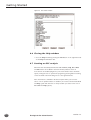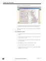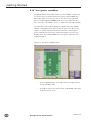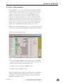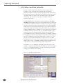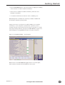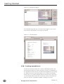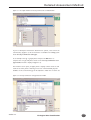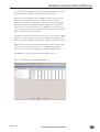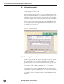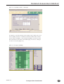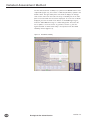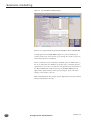
1
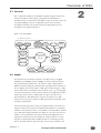
Ecological Site
Classification
A PC-based Decision Support System
for British Forests
User’s Guide
Version 1.7 May 2001
Duncan Ray
© Crown Copyright 2001
ISBN: 0 85538 537 5
Produced in the United Kingdom
FCESC1.7/PPD(ECD)/250/MAY01
Licence Agreement
This licence applies to Ecological Site Classification (ESC) version 1.7
You should carefully read the following terms and conditions before using this software.
Your use of this software indicates your acceptance of this licence agreement and warranty.
Subject to the terms below, you are hereby licenced to use this software. You have been
registered as an authorised user and you are specifically prohibited from distributing the
software and/or documentation with other products (commercial or otherwise) without prior
written permission. UNDER NO CIRCUMSTANCES ARE YOU LICENCED TO ALLOW
UNREGISTERED USE OF THE SOFTWARE, OR RESELL THE PROGRAM TO A THIRD PARTY.
You shall not alter, modify or reverse engineer the original software or give anyone else
permission to do so. Unregistered use of the Ecological Site Classification software is in
violation of UK and international copyright laws.
Disclaimer of Warranty
THIS SOFTWARE AND THE ACCOMPANYING FILES ARE DISTRIBUTED “AS IS” AND
WITHOUT WARRANTIES AS TO PERFORMANCE OR MERCHANTABILITY OR ANY OTHER
WARRANTIES WHETHER EXPRESSED OR IMPLIED. In particular, there is no warranty for the
predictions made by the model as they are regarded as indicative and not prescriptive.
NO RESPONSIBILITY FOR LOSS OCCASIONED TO ANY PERSON OR ORGANISATION ACTING,
OR REFRAINING FROM ACTION, AS A RESULT OF ANY MATERIAL IN THIS PRODUCT CAN
BE ACCEPTED BY THE FORESTRY COMMISSION.
The Ecological Site Classification software is PC-based and is compatible with Microsoft®
Windows®3.1 and Microsoft® Windows®95, Windows®98 and Windows NT® operating systems.
Because of the various hardware environments into which ESC software may be installed;
NO WARRANTY OF FITNESS FOR A PARTICULAR PURPOSE IS OFFERED.
The installation disks have been thoroughly tested for computer viruses with the latest virus
checking technologies available at the Forestry Commission. However, the user must assume
the entire risk of using the ESC program and therefore nobody apart from the user will be
responsible for the loss of critical data or any other damage to the systems as a result of
virus attack or any malfunction of the program.
Trademarks
All terms mentioned in this book that are known to be trademarks or service marks have
been marked as such. The Forestry Commission cannot attest to the accuracy of this
information. The use of a term in this Manual should not be regarded as affecting the
validity of any trademark or service mark. Readers should contact the appropriate
companies for more complete information regarding trademarks and registration.
Ecological Site Classification
version 1.7
Contents
Preface
1
Introduction
ESC Background
ESC Models – a note of caution
Why use ESC?
1.1
1.1
1.1
1.2
2
Overview of ESC
General
Inputs
ESC Site Type and Suitability Model Calculations
Outputs
Help
2.1
2.1
2.1
2.2
2.3
2.3
3
Installing ESC
System requirements
Installing ESC
Moving the icon on to your desktop
Associating icons with the shortcut
3.1
3.1
3.1
3.2
3.2
4
Getting Started
Running the ESC program
Cue cards and Help system
Switching Cue cards on and off
Cue cards links to the Help System
Help system Search facility
Closing the Help window
Starting an ESC analysis
Site location
Climate results
ESC to Go
ESC to Go – Shortcut method information window
Tree species suitability
ESC yield prediction
Native woodland suitability
Saving an ESC analysis
Opening an ESC analysis
Saving window images
Printing reports
Embedding images in reports
Creating Spreadsheets
5
Detailed Assessment Method
ESC Pro
Introduction to soil classifications
Introduction to indicator plants
Selecting Forestry Commission soil types in ESC
Exploring soil phase and rooting depth options
Selecting Soil Survey of Scotland and Soil Survey of England
and Wales in ESC
Selecting humus form in ESC
Selecting indicator plant species in ESC
Soil quality results
Ranking the results
5.1
5.1
5.1
5.2
5.2
5.4
6
Scenario modelling
6.1
7
References
7.1
8
Field Survey Pack
8.1
version 1.7
4.1
4.1
4.2
4.2
4.3
4.3
4.4
4.4
4.5
4.6
4.8
4.11
4.12
4.13
4.14
4.16
4.16
4.16
4.16
4.17
4.18
5.5
5.6
5.6
5.8
5.8
Ecological Site Classification
Preface
Welcome to Ecological Site Classification A PC-based Decision Support System for British Forests
Acknowledgements
Ecological Site Classification (ESC) was funded and developed by the Forestry
Commission, as a project within the Woodland Ecology Branch of Forest Research.
The direction of the ESC development was steered by the ESC User Group comprising:
Chris Langton
Alec Byden
Jo O’Hara
Clive Thomas
Ian Collier
–
–
–
–
–
Atholl Estates
Tilhill Economic Forestry
Forest Planning, Forest Enterprise
Forest Enterprise Wales
Forestry Commission Highland Conservancy
In addition: Bill Rayner, Chris Quine, Simon Hodge, Graham Pyatt, Alice Broome,
Jonathan Humphrey and Wilma Harper, provided valuable advice and criticism of
the program. Finally, we wish to thank and acknowledge the valuable comments
received from people in the forest industry and academic institutions who tested
earlier prototypes and demonstration versions of ESC.
Credits
Ecological Site Classification Development:
Graham Pyatt, Juan Suarez, Duncan Ray, Gary White and Jane Fletcher
Software Development:
Duncan Ray with support from John Slade (Knowledge Garden Inc, Palm Beach,
Florida)
Testing:
Graham Pyatt, Scott Wilson, Chris Langton, Clive Thomas, Jason Sinden, John
Gallagher, Alex Bryden, Ian Collier, John Priddy, John Hair, Roger Wilson, Fiona
Kennedy, Jonathan Humphrey, Alice Broome, Russell Anderson, Duncan Ray
User’s Guide and publication:
Duncan Ray and Elaine Dick
For further information and latest updates visit the ESC website at:
www.forestry.gov.uk/esc
For help and assistance email:
[email protected]
or contact:
Duncan Ray
Woodland Ecology Branch
Forest Research
Northern Research Station
Roslin
Midlothian
EH25 9SY
United Kingdom
Ecological Site Classification
version 1.7
Introduction
1.1 ESC background
Work on Ecological Site Classification (ESC) began in 1992. The project was
conceived by Graham Pyatt following a study tour of the Biogeoclimatic
1
Ecosystem Classification (BEC) system, used to classify the natural forest types
of British Columbia. Similar approaches have been suggested for use in
Britain (Anderson, 1950) and the methodology is used fairly widely across
Europe and North America (Cajander, 1926), (Krajina, 1969), (Kuusipalo,
1985; Klinka, Krajina et al. 1989), (Cleland, Hart et al. 1993). The ESC
methodology took shape over four years and the project was expanded in
1996, following a Forest Research discussion meeting to consider decision
support system tools in forest ecology. A focus was the developing policy for
sustainable forestry in Britain; the vision was a user-friendly computer based
decision support system that could deliver the complex methodology of ESC
allowing users to assess the ecological suitability of alternate forest planning
options. It was envisaged that the development of ESC would provide a core
for linked modules designed to guide forest managers and planners by
indicating the likely effects of management on forest ecology.
ESC classifies a site in terms of its climate and soil quality. It assesses the
suitability of alternate tree species and woodland community choices, based
on the match between key site factors and the ecological requirements of
different species and woodland communities. Forestry Commission Technical
Paper 20 An Ecological Site Classification for Forestry in Great Britain with
Special Reference to Grampian, Scotland established the methodology with
reference to Grampian, Scotland. Since then the climate data have been
recalculated for the whole of Britain, based on the Meteorological Office 30
year recording period (1961–1990) (Pyatt, Ray et al. 2000). The Forestry
Commission windiness scores (DAMS) (Quine and White, 1993) have been
calculated for the whole of Britain. The list of plant indicator species have
been revised following work by Wilson (1998), and the revision of Ellenberg’s
plant indicator species (Ellenberg, 1988) for Britain (Hill, Mountford et al.
1999) has been included. The ESC suitability model has been developed
from a multi-criteria analysis approach (Ray, Suarez et al. 1996), to a method
using fuzzy-set theory (Ray, Reynolds et al. 1998) described by Zadeh (1992).
1.2 ESC models – a note of caution
This decision support system is intended as a site-based tool to help the
forest manager check the suitability of a given site to a range of tree species
and woodland types. It has never been the intention to build a program that
might dispense with professional judgement.
The program should be used as a decision support tool, and while it may
help reassure the professional forest manager, it is no substitute for
professional advice.
Models within the system are based largely on ‘rules of thumb’. The
yield models are knowledge-based representations that combine
observations, experimental results, species trial results and the
professional experience of a number of Forestry Commission scientists.
version 1.7
Ecological Site Classification
1.1
Introduction
Linkages between ESC and the National Vegetation Classification (NVC) are
based on work by Pyatt (in prep), using the published material of Rodwell
(1991) and Rodwell and Patterson (1994).
ESC is a developing decision support system. Although the system has
been tested, inevitably there will be errors and bugs in the program.
Please report problems to:
[email protected]
1.3 Why use ESC?
Matching suitable species or woodland types to site conditions is a
fundamental aspect of practicing sustainable forestry. ESC can help by
supplying the reference material to support your decision. If you want to
plant new native woodlands, and find NVC methods difficult due to the
lack of precursor vegetation, then ESC can provide assistance.
1.2
Ecological Site Classification
version 1.7
Overview of ESC
2.1 General
ESC is a Microsoft® Windows® compatible computer program, which steers
the user through the methodology of Ecological Site Classification. It
2
prompts the user for information, and applies a series of models to assess the
ecological suitability of the site for plantation grown trees and native
woodland communities. In general terms the program guides the user
through the flow diagram in Figure 1.
Figure 1. The ESC program
Minimum site information
INPUTS
Grid
Reference
Soil type
Elevation
rooting depth
stones
texture
Lithology &
soil type
Humus form
Indicator
plants,
% cover
CLIMATE
Accumulated
temperature
SOIL QUALITY
Moisture
deficit
Windiness
Ecological Site
Classification
Soil Moisture
Regime
Site type
Soil Nutrient
Rigime
Continentality
OUTPUTS
Tree species
suitability
ESC yield
prediction
Woodland
suitabilty
2.2 Inputs
The minimum site information required to be input for ESC is the grid
reference, the elevation and the soil type. From these data the climatic
factors (accumulated temperature - AT, moisture deficit - MD, windiness DAMS and continentality) are calculated, but only approximate estimates of
the soil quality (soil moisture regime - SMR, and soil nutrient regime - SNR)
can be made. If more information is known about a site, e.g. rooting depth,
soil texture and stoniness, a more precise estimate of the SMR can be made.
If lithology is known this is combined with soil type to provide a more
precise estimate of SNR. Humus form can give more precision to SNR,
however, the most precise estimate of SNR is gained from knowledge of the
field layer vascular plants.
The ESC methodology allows a range of bio-physical data to be used in an
analysis and this can commonly show apparent discrepancies in soil quality
estimation. The problem is that it is very difficult if not impossible to obtain a
set of data that accurately describes the quality of a site. One must review a
number of site characteristics and exercise professional judgement. ESC is
designed to aid this process. ESC attempts to classify site factors in a way
that gives an approximate but workable estimate of continuously varying
factors. The plant indicator species will give a more precise estimate of soil
version 1.7
Ecological Site Classification
2.1
Overview of ESC
nutrient regime than a soil type. ESC uses the plant indicator species as
surrogates for a soil chemical analysis, to demonstrate the availability of
nitrogen in the soil. Knowledge of the soil type and its description variables
give a more precise estimate of the soil moisture regime than do plant
indicator species. A soil description will offer visible physical evidence of the
wetness state.
Two methods are offered in ESC to enter the soil quality information. The
first is called ESC to Go and is a shortcut method that gives an approximate
estimate of SMR and SNR from quick observations of the soil and vegetation
at the site.
The second method is called ESC Pro, and utilises precise descriptions
of the soil type and lithology, the humus form, and the field layer plant
community. ESC accepts both the presence and percent cover of the plant
indicator species from vegetation surveys using up to 10 quadrats. The ESC
plant survey method can be similar to that recommended for National
Vegetation Classification (NVC) surveys, but the ESC Pro method requires
key soil attributes to be recorded. An ESC survey therefore requires a more
comprehensive soil survey than the typical NVC survey.
2.3 ESC Site Type and Suitability Model
Calculations
Estimates of six ESC factors AT, MD, DAMS, Continentality, SMR and SNR
are made from the site data. Each factor is used to describe the degree of
suitability for a given tree species or woodland. The factor that offers the
lowest degree of suitability for a given site is said to be ‘the limiting factor’
for the site and thus determines the overall suitability of the site to that tree
species or woodland community. Tree species suitability is calculated in a
slightly different way to native woodland community suitability. For each
tree species, AT determines the potential yield at the site, and is then
modified by the most limiting of the remaining 5 ESC factors. The method
allows ESC to predict the yield of the species on the site. The suitability is
governed broadly by the predicted yield. The ‘Very Suitable’ class requires
the species to achieve 75% or more of its maximum yield in Britain (as noted
by Edward and Christie, 1981. A species is ‘Suitable’ if ESC predicts between
50%–75% of its yield maximum in Britain, and is ‘Unsuitable’ for the site if
ESC predicts the yield will be less than 50% of the maximum for that species
anywhere in Britain.
Caution: The ESC yield models are knowledge-based representations from
species trials, observations and the experience of forest scientists, and are not
formally validated.
2.2
Ecological Site Classification
version 1.7
Overview of ESC
2.4 Outputs
ESC produces a report of the site information and the calculated ESC factors
used in the analysis. The suitability diagrams, ESC yield predictions and native
woodland suitability predictions can be printed or saved as bitmap files
(*.bmp ) and inserted into the ESC report generated in Microsoft® Word 97.
The output data can be saved as a comma separated format file (*.csv),
allowing a convenient method of input to a spreadsheet. The program
automates the production of a report in Microsoft® Excel 97.
2.5 Help
ESC includes a context sensitive cue card system and comprehensive help
system. The help system contains all the background information to ESC.
version 1.7
Ecological Site Classification
2.3
Overview of ESC
2.4
Ecological Site Classification
version 1.7
Installing ESC
3.1 System requirements
ESC will run on IBM compatible personal computers. PCs must have:
3
• CD-ROM drive (ESC databases remain on CD and the program will not
run without the CD installed)
• a 486 (or later) processor
• 4 Mb of free hard disk space
• 8 Mb of RAM (minimum)
• Microsoft® Windows® 3.1, 95, 98 or NT4 operating system
By default ESC will install on your hard disk in the directory c:\ESC, although
it can be placed in any other directory by adjusting the choices offered
during the installation program.
3.2 Installing ESC
• Place the CD in the CD drive (usually drive D:).
• Press Start button.
• Press Run button.
• type d:\setup.exe (Figure 3.1).
NOTE: The program will not install if you refuse to agree to the conditions of
use. By installing the software on your machine you are agreeing to the terms
and conditions.
Figure 3.1 The setup box
Once the setup.exe has installed ESC, a file group will be created in a new
window (Figure 3.2). The file ESC can be copied as a shortcut onto your
desktop.
If you have a sound card loaded, the setup program will play an audio
introduction as you install. A ‘file not found’ error message may appear if no
sound card is installed. Clear the error message by selecting OK/Continue.
The installation will offer alternatives to the default paths for program and
file locations. You must select OK/Continue to accept the defaults.
version 1.7
Ecological Site Classification
3.1
Installing ESC
Figure 3.2 New window showing ESC file group
3.3 Moving the icon on to your desktop
• Right click and hold down the button on the ESC icon.
• Drag the icon out of the window onto the desktop while continuing
to hold the right button.
• When you release the right mouse button on the desk top, select Create
Shortcut Here.
3.4 Associating icons with the shortcut
• Right click on the shortcut and select Properties.
• Choose the Shortcut tab.
• Press Change icon and select an icon from the menu window.
3.2
Ecological Site Classification
version 1.7
Getting Started
4.1 Running the ESC program
ESC will not run without the CD installed. All of the windiness (DAMS)
scores reside on the CD, and the program will run an initial check to register
4
this data.
To run the ESC program:
• Double click the ESC icon with the left mouse button.
• ESC will launch.
When the program has loaded, it will check the data files are loaded in the
CD drive (Figure 4.1).
Figure 4.1 Checking the ESC CD is loaded
!
You will crash the ESC software if you attempt to load it while loading another program
• If you know the ESC CD is loaded in the CD drive, click OK without waiting.
• If you have to open the CD drive to check the ESC CD is installed, you will
need to wait a few seconds after closing the drive door to allow the CD to
register with the operating system.
• When you press OK, ESC will automatically check where your CD drive is,
and look for the data files it needs.
version 1.7
Ecological Site Classification
4.1
Getting Started
4.2 Cue cards and Help system
Context sensitive cue cards update automatically as you work and can be
switched on and off. Hypertext links lead to more information in the help
system.
• Cue cards are designed to help you quickly understand and run the
program and appear when you launch the program (Figure 4.2).
• Cue cards are context sensitive and will change automatically as you
progress through ESC.
• The Cue card window can be formatted, to allow you to fit it onto your
desktop alongside ESC. To adjust the window size, move the cursor over
the edge of the window until a double ended arrow appears, hold the left
mouse button down and adjust the size of the window.
Figure 4.2 Cue cards
4.3 Switching Cue cards on and off
• Pressing the Close button on a Cue card will close the current Cue card.
• Toggle the tick box to deactivate/activate a particular Cue card.
• To switch all Cue cards on or off, press Help on the main window tool bar
of ESC (Figure 4.5) followed by the Cue card toggle switch, to activate/
deactivate the Cue card window while running ESC.
• If you have Cue cards deactivated when running ESC, pressing the Help
button within any window will launch the Cue card relating to that window.
This will provide information and further access to the main Help system.
4.2
Ecological Site Classification
version 1.7
Getting Started
4.4 Cue card links to the Help system
• Cue cards have hypertext links to Help information embedded in a blue
font. Selecting a hypertext link anywhere in ESC will launch the Help
window with that item loaded (Figure 4.3).
• Pressing Help in any window with Cue cards deactivated will open the
Cue card relevant to the request.
• The Help information also contains blue hypertext links.
• Selecting the hypertext links within Help will automatically launch the
related information.
4.5 Help system Search facility
• Press Search on the Help window button bar (Figure 4.3) to open the
Search window (Figure 4.4).
• Type in a search request, e.g. ‘Forestry Commission Soil Type’ and press
Go To.
• Select a Forestry Commission Soil Type name to view the image.
• Search, Back and Contents are used to navigate the Help system.
Note: Images cannot be printed from the Help system, only text may be printed.
Figure 4.3 ESC Help window
version 1.7
Ecological Site Classification
4.3
Getting Started
Figure 4.4 ESC Search window
4.6 Closing the Help window
• Close the Help window by pressing the Exit button on the right hand side
of the Help window button bar.
4.7 Starting an ESC analysis
When ESC has successfully launched the Site Location, Help, Reset Data
and Exit buttons are enabled in the main window; buttons shown in
monochrome are disabled (Figure 4.5). The main window has a schematic
layout, inviting the user to operate the program by pressing buttons starting
on the left hand side and working across to the right hand side.
More information is available in the bottom panel when you hover the
cursor over an operative button. In addition, the context sensitive Cue cards
and Help system will offer hints on the procedure (see Sections 4.2–4.6 on
Cue cards and Help system).
4.4
Ecological Site Classification
version 1.7
Getting started
Figure 4.5 ESC Main window
Work from left to right along the button bar. First you enter information
about Site Location (Section 4.8) followed by the ESC to Go short cut
method (Section 4.10) or the ESC Pro detailed method to describe soil type,
humus, lithology and plant indicator species (Section 5).
4.8 Site location
• Press the Site Location button in the main window (Figure 4.5).
• The Site Location data entry window (Figure 4.6) is displayed.
• Enter the site name (the default example is ‘ESC Site 1’).
• Enter a grid reference to 100 m (e.g. NT 250640).
• Enter the site elevation (e.g. 175 m).
• Press OK to proceed.
version 1.7
Ecological Site Classification
4.5
Getting Started
Figure 4.6 Site Location data entry window
The 100 Km grid square can be selected by clicking on the map of Britain,
or alternatively by selecting the 100 Km square in the combination box.
Note: The program will fail to run at this point if the ESC CD is not installed in
the CD drive.
4.9 Climate results
• The Climate Results window (Figure 4.7) shows the ESC climate factors at
your site.
• A pointer indicates the approximate position of the site and helps ensure
your grid reference is correct.
• You can examine the site climate factors in relation to the regional data
by pressing Zoom In.
• Zoom Out brings you back to the Climate Results window.
• Complete the Site Location module by pressing OK.
• The climate results and site information can be viewed by selecting Site
Summary in the main window.
4.6
Ecological Site Classification
version 1.7
Getting Started
Figure 4.7 Climate Results window
Note 1: Windiness (DAMS) is not calculated within ESC, therefore any changes
to elevation for a given grid reference will change Accumulated Temperature (AT),
Moisture Deficit (MD) and Continentality but it will not affect the DAMS score.
Note 2: Calculated climate factors (100 x 100 m resolution), and values
reported on the 100 Km square map (250 x 250 m resolution) may differ
due to differences in the resolution of the data.
version 1.7
Ecological Site Classification
4.7
Getting Started
4.10 ESC to Go
You can select/deselect the tick boxes showing the information you wish to
enter. Both Soil Types and Main Indicator Plants may be selected, as
shown in Figure 4.8. Alternatively you can enter either of these options
independently. When you press OK the input windows you have selected are
displayed sequentially.
Figure 4.8 ESC shortcut method information window
Figure 4.9 shows the Forestry Commission Soil Types window. The window
displays a schematic diagram showing the main soil types placed in position
on the soil quality grid showing Soil Moisture Regime (SMR) plotted against
Soil Nutrient Regime (SNR). Note the ‘Very Dry’ and ‘Very Poor soils’, e.g.
rankers and shingle (thin and very stony soils) are in the top left corner.
Brown earths occupy the centre of the diagram, and peaty soils are along
the base of the diagram.
• Select a soil type by pressing the left hand button on the mouse over one
of the boxes in Figure 4.9. The soil type can also be selected by pressing
the left mouse button over an item in the list box to the right of the
diagram in Figure 4.9.
• Press OK to proceed.
4.8
Ecological Site Classification
version 1.7
Getting Started
Figure 4.9 Forestry Commission Soil Types window
If both Soil Type and Main Indicator Plants were selected in Figure 4.8,
when soil selection is complete the ESC Indicator Plants window (Figure
4.10) will be displayed. The plant common names are displayed
schematically in the position they represent as indicators of soil quality
defined by the approximate centre of their ecological niche.
Figure 4.10 ESC Indicator Plants window
version 1.7
Ecological Site Classification
4.9
Getting Started
The use of the ESC Indicator Plants window is a little more complex than the
soil selection. To use this option you must know the main species of plant in
the field layer, and particularly; the most abundant vascular plants present
and their approximate cover proportion. With this information in mind,
choose a point on the ESC Indicator Plants window which represents the
‘centre of gravity’ of the plant community. In determining the centre of
gravity imagine each plant listed occupies the central position of the cell
containing its name. For example, if your site had 5 abundant plant species:
broad buckler-fern
50%
creeping soft-grass
30%
wood sorrel
10%
bracken
10%
tufted hair-grass
5%
This selection of plants would indicate a centre of gravity at about the point
shown by the ‘pointing hand’ cursor in Figure 4.10 and in detail in Figure 4.11.
Figure 4.11
• Select the position representing the centre of gravity of indicator plants on
the site by pressing the left hand mouse button.
• Press OK to proceed.
Note: If there are two plants with an equal cover proportion of say 50% and
they occupied adjacent cells, the selection position would be midway between
the cells. In practice you cannot select between two adjacent cells and will have
to use some judgement in deciding on which cell to choose. Another way around
this problem will become apparent later, when we explore scenario modelling
and sensitivity analysis. If you are unsure about choosing one or more cells,
choose one for now and make a note of the other possibilities to explore later.
Caution: ESC to Go is intended as a quick check ESC analysis. On some sites it
may not give an accurate estimate of soil quality. Whenever possible, check the
ESC to Go results with a detailed ESC Pro analysis.
4.10
Ecological Site Classification
version 1.7
Getting Started
4.11 ESC to Go – Shortcut method information
When Soil and Indicator Plant selection is complete, the Shortcut Method
Information window will be displayed (Figure 4.12). The SMR and SNR
default values from Soil Type selection and from the Indicator Plant selection
are displayed. The bottom line of the table indicates the default values
chosen by the program to use in the suitability analysis. The rules governing
the choice assume the soil type will give the best estimate of SMR and the
indicator plants give the best estimate of SNR. If only soil type or indicator
plants are used, both SMR and SNR are set by that method.
Figure 4.12 Shortcut Method Information window
ESC Shortcut method information window:
• The Shortcut Method Information window (Figure 4.12) shows soil quality
defaults selected.
• Press OK to complete the ESC to Go shortcut method.
• All the graphics buttons will now become active, including Species
and Woodlands which are covered in the next two sections.
version 1.7
Ecological Site Classification
4.11
Getting Started
4.12 Tree species suitability
The Species button on the Main window tests the suitability of twenty four
tree species at the site defined by the 6 ESC factors in Site Location and
ESC to Go. Figure 4.13 shows the value of each factor in the right hand
panel of the Tree Species Suitability window. For our example ESC Site 1:
AT = 1229, MD = 109, DAMS =14, Con = 6, SMR = Fresh and SNR = Medium.
The main panel of the window displays the suitability class (Very Suitable,
Suitable or Unsuitable) by ESC factor for the 24 species. The object of the
output is to quickly understand which of the ESC factors is limiting tree
species suitability. The result of this multi-criteria analysis is shown in the
Result column. Note that the Result tile for any species reflects the most
limiting ESC factor.
Figure 4.13 Tree Species Suitability window
• Press the Species button on the Main window to display the Tree
Species Suitability results.
• Press OK to return to the Main window, or Site Yield for ESC Yield
Prediction (Section 4.13).
4.12
Ecological Site Classification
version 1.7
Getting Started
4.13 ESC yield prediction
The Site Yield button on the Tree Species Suitability window will display the
Estimated Yield Class window (Figure 4.14). The site data used in the yield
models are displayed in the right hand panel (as in Figure 4.13). The list of
tree species are as in Figure 4.13 and the suitability Result column from
Figure 4.13 is displayed to the right of the species list in Figure 4.14. The
main part of the result panel of Figure 4.14 shows the ESC Estimated Yield
graphically. The grid indicates the normal yield range of each species, from
the minimum yield (at a level the species would normally be described as ‘in
check’), up to the maximum yield for the species in Britain (Edwards and
Christie, 1981). To the right of the graphical output are two columns that
indicate the ESC yield prediction and the ESC factor that limits yield.
Caution: The ESC Yield model predictions are from ‘rule of thumb’ knowledge-based
models, that have not been formally validated and should be treated with caution.
Figure 4.14 Estimated Yield Class window
• From the Tree Species Suitability window (Figure 4.13), press Site Yield
to run the site data through the set of ESC yield models and the ESC yield
prediction for the 24 species is displayed (Figure 4.14).
• Press OK to return to Tree Species Suitability window.
• Press OK to return to the Main window.
Note: The example illustrates why both the Suitability analysis and Yield analysis
should be considered together. Although only three species were ecologically
‘Very Suitable’, the ESC yield models estimate higher yields from several species
regarded as only Suitable on this site.
version 1.7
Ecological Site Classification
4.13
Getting Started
4.14 Native woodland suitability
There are similarities between the definition of ESC site types and the
description of sites associated with the twenty National Vegetation
Classification (NVC) woodland communities (Rodwell, 1991). Work by Pyatt
(in press) demonstrates the link between ESC and NVC, and shows how ESC
can predict suitable site types for NVC woodland as well as open habitat
communities. ESC Version 1.7 shows only the suitability of the NVC
woodland communities.
The Woodlands button on the Main window will display the Woodland
Suitability window (Figure 4.15). This shows the relative degree to which each
of the 20 NVC woodland communities is suited to the site conditions. Again
the ESC site factors that comprise the input data to the woodland suitability
models are shown in the right hand panel. The list of woodland communities
codes and description are listed in the left hand column. The central panel
displays a graphical measure of suitability. The score ranges from 0 (completely
unsuitable) on the left of the lower axis, to 1 (completely suitable) on the
right of the lower axis. The Result column contains white (unsuitable) or
green (suitable) tiles. This is a summary representation of suitability, compared
to the graphical, continuous representation. A woodland is allocated a green
tile when its suitability score becomes greater than or equal to 0.7. Scores
less than 0.7 are considered unsuitable. On a given site, if no woodland
community has a score of 0.7 or more, the site may be more suited to open
habitat, such as a mire or heathland community, which is beyond the scope
of ESC Version 1.7, but may be included in future developments.
The numbers 1, 2 or 3 displayed in the Result column refers to the order
ranking; 1 is ranked the highest, but does not indicate the community is suitable.
The 1,2 3 nomenclature will appear even if all of the Results tiles are white,
indicating all communities are unsuitable.
Figure 4.15 Woodland Suitability window
4.14
Ecological Site Classification
version 1.7
Getting Started
• Press the Woodlands button in the main window to display the suitability
of the site factors for NVC woodland communities.
• Green tiles show suitable woodland communities, white tiles show
unsuitable communities.
• 3 woodland communities are ranked in order of suitability score.
Note: Ranking does not indicate the community is suitable; woodlands can
be restricted on regional or policy grounds.
Finally in this section, consider the ecological suitability of a woodland
community to a site, irrespective of policy issues. If you have a site in
Scotland outside the native pinewood area, but don’t want ESC to consider
the policy boundary definition, then press the View All button. Figure 4.16
will be displayed. Pressing Restrict will impose the policy restrictions.
Figure 4.16 Woodland Suitability - ‘View all’ option
Note: Precision of the View All/Restrict toggle function is a 100 Km square.
Better resolution will need to be ascertained from other sources.
version 1.7
Ecological Site Classification
4.15
Getting Started
4.15 Saving an ESC analysis
To save an ESC analysis, select File ➝ Save from the Menu Bar, or File ➝
Save As to save to a new filename (Save As will open by default if the analysis
is currently unsaved). The command opens the file menu and prompts you
to save a file with the extension *.esc in the default c:\esc\data path.
Note: Unfortunately this does not give you the opportunity to save scenarios that
you have set up using the scenario editor (Section 6.1).
4.16 Opening an ESC analysis
To reopen a previously Saved ESC analysis, select File ➝ Open from the
Menu Bar.
If in the saved analysis you had used the ESC Pro method to input Indicator
Plant Species (Section 5.5), ESC will reopen up to the point of the saved
species and abundance scores set out in the Percent cover window (Figure
5.5). To continue press OK.
Note: There is a small bug in the system if you use the Back button to modify
saved species. Before Adding or Removing species from a saved analysis in Figure
5.4, press the Latin radio button. This will ensure the names in the saved list and
the radio button are synchronised. You must click the Latin button even if the latin
plant names are already selected. Having pressed Latin you can change it back
to Common if you wish to continue the analysis with common names for plants.
4.17 Saving window images
All of the results windows have controls that allow you to get hard copy of
the results. Most windows contain a Print button and a Save Bitmap button.
• The Print button will send the results image to your default printer.
• The Save Bitmap button opens the file menu window in which you allocate
a filename to save the output bitmap. By default a name derived by ESC
from the site name (shortened if necessary) will be offered. You can call
the file by any name, however the file created is a bitmap with a .bmp file
extension. There are advantages and disadvantages to using the .bmp
format. Building the functionality into the ESC program was relatively
straightforward using *.bmp format. However, bitmap files are very large
and so you may need to keep your saved bitmaps to a minimum, and
delete unwanted files regularly. The *.bmp images from the analysis can
be easily embedded into the Word 97 ( or later) report that ESC generates.
4.18 Printing reports
The increasing availability of Word 97 on PCs has allowed a neat solution
to generating and printing analysis reports from ESC. The ESC Site Summary
button opens a ESC analysis summary window that can be viewed. There is
not a print button within the ESC Site Summary window.
4.16
Ecological Site Classification
version 1.7
Getting Started
To print a report of the analysis, press the Word report button. Word 97 will
be launched and a report generated automatically. You can make additions
and comments and print the report under Word 97 control.
Windows NT users may find that Word does not launch automatically.
However the *.rtf file (rich text format) will have been created and saved
with the name and location chosen. Simply double click on the *.rtf file
within Windows Explorer. If you don’t have Microsoft Word, you should be
able to read the *.rtf file in another package such as WordPad, within your
Programs Accessories folder.
4.19 Embedding images in reports
You will have already saved the image(s) you wish to embed in the report as
*.bmp files (see Saving window images, Section 4.17) while running the
analysis. Now generate a Word 97 report (see Printing reports, Section 4.18).
Figure 4.17 shows the control sequence to Insert ➝ Picture ➝ From File
within Word 97. Note that prior to importing the picture you should place
the cursor at the place in the report you wish the file to be embedded.
Selecting the menu options shown in Figure 4.17 will open a file menu, the
saved bitmap file should be within the c:\esc\data directory by default.
You will have to navigate through the file structure to that directory, or the
directory in which you saved the file. Select the filename and press Insert
(Figure 4.18). Remember to delete bmp files after you have inserted them
into a document. They are very large and will quickly fill your disk space.
Figure 4.17 Inserting an image from file.
version 1.7
Ecological Site Classification
4.17
Getting Started
Figure 4.18 Selecting the image file.
The embedded image will open in the Word report (Figure 4.19). You can
add comments and discussion to the report as required.
Figure 4.19 The finished report.
4.20 Creating Spreadsheets
The ESC Site Summary window also contains an Excel Report button. This
will launch Excel with the site data entered into the cells of a spreadsheet. If
the spreadsheet already exists the new data will be appended to the existing
file. Windows NT users may find that Excel does not launch automatically.
However the *.csv (comma separated value) file will have been created, and
can be manually imported into Microsoft Excel. If you don’t have Microsoft
Excel you may have a spreadsheet capable of reading *.csv format.
4.18
Ecological Site Classification
version 1.7
Detailed Assessment Method
5.1 ESC Pro
ESC Pro offers the user the standard methodology of classifying the soil
quality of a site as described in the ESC Bulletin (Pyatt, Ray et al., 2001).
5
The main difference between ESC to Go and ESC Pro is the increased
precision of the soil quality estimate for a site type.
This section describes the Forestry Commission Soil Classification input and
the Indicator Plant Species input. Note that in the evaluation setup window
it is possible to select all the input check boxes, causing the program to
guide you sequentially through all of the options. If you were to do this the
program would set soil quality defaults separately for each method, with the
exception that the default SMR and SNR set for the Soil Survey of Scotland
Soil Classification method will be overwritten by the Soil Survey of England
and Wales Soil Classification method. Since you will only enter data from
one or the other system, the input methods are mutually exclusive. Select
the check boxes for which you have site data.
5.2 Introduction to soil classifications
ESC uses the Forestry Commission Soil Classification (Pyatt, 1982), and offers
increased precision in classifying soil types when obtained from maps at a
scale of 1:10 000. The national soil classifications are based on soil data
mapped at a scale of 1:50 000 and 1:250 000, and so are rather imprecise
at the stand scale. In order to represent soil types mapped at a small scale,
the national soil survey maps group soils together as an association. Each
association may contain a range of soil types with different SMR and SNR
attributes. The soil quality defaults set by ESC are based upon the most
widespread or likely soil type encountered in an association, but there is no
guarantee that a site defined by the user will have the default soil quality
values. In contrast, the Forestry Commission Soil Classification soil types are
likely to have been surveyed and mapped at a scale of 1:10 000. The link
between soil quality estimates and soil type is thus more precise, but not
guaranteed. The best information is from a site visit and survey.
The Forestry Commission Soil Classification was developed in the 1960s and
1970s (Pyatt 1970, Pyatt 1977), to help foresters identify waterlogging and
nutritional problems in soils. Although the emphasis has moved from purely
commercial considerations to multi-benefit forestry, the Forestry Commission
Soil Classification remains an accessible system for forestry purposes. Users in
the lowlands may feel the classification is biased towards upland forest soils,
but this reflects the particular forest soil related difficulties on upland sites.
ESC users unfamiliar with the Forestry Commission Soil Classification may
find the conversion between soil types described by Avery (1990) and the
Forestry Commission of help in accessing ESC. A table giving Avery and
Forestry Commission Soil type equivalence can be found in the Help system,
under Avery.
version 1.7
Ecological Site Classification
5.1
Detailed Assessment Method
5.3 Introduction to indicator plants
A detailed discussion of indicator plants is given in (Pyatt, Ray et al. 2000).
Two indicator plant models are used in ESC. The first uses a list of 52 plants
identified by Wilson (1998) as commonly occurring in British woodlands.
Wilson’s list of 52 plants reliably estimate the SNR of the site if their average
cover proportion is 70% or greater. The second model uses a list of 132
plants from a total list of 1200 species listed by Ellenberg (1988) and
recently revised for British conditions by Hill, Mountford et al. (1999). ESC
does not use the complete list of 1200 species as this would cause data
input problems for the non-expert user.
The list of 132 include species of regional and national importance in
woodland and open habitats and should provide ample scope for indicating
SNR on most sites. ESC decides which of the two models should be used in
an analysis, and the user is offered an assessment of the SNR based on the
most favourable model for the site.
The list includes only vascular indicator plants. ESC does not use any of the
bryophytes or lichens commonly used in the NVC methodology. Instead,
ESC infers the link between climatic factors and the likelihood of suitable
conditions for the establishment and maintenance of a rich bryophyte flora
in those NVC woodland communities that are classed by the presence of
bryophytes. For the non-expert botanist ESC reduces the number of plant
indicators needed to assess soil quality, to a practical level.
The number of quadrats surveyed within each site type should reflect the
variation and patchiness of the vegetation. You will need to survey more
quadrats where vegetation is very patchy compared to sites where the
species are intimately mixed within a 2 m x 2 m quadrat. If there are
considerable differences in the vegetation community within the area you
are considering, then you may have to sample the areas separately to test
if they are different site types.
5.4 Selecting Forestry Commission soil types in ESC
The input window for Forestry Commission Soil Classification (Figure 5.1)
prompts you first for a soil type, followed by a permitted phase associated
with the type (as necessary). Figure 5.1 shows the window with the type ‘1u
– upland brown earth’ selected and the corresponding list of phases that can
be associated with a type ’1u’.
5.2
Ecological Site Classification
version 1.7
Detailed Assessment Method
Figure 5.1 The input window for Forestry Commission Soil Classification
If your soil description warrants the attachment of a phase, select it from the
Soil Phase Key (Figure 5.1). More information is available in the Help system
under Forestry Commission Soil Types.
As an example select ‘g’ a gleyed phase and press the OK button to
complete the soil type and phase selection. The Forestry Commission Soil
Type Results window is displayed (Figure 5.2).
The window has two parts; an upper panel to display current selections and
results and a lower panel containing 5 list boxes in which default physical
attributes of the soil and lithology can be adjusted to match the soil at the site.
Figure 5.2 Forestry Commission Soil Type Results window
version 1.7
Ecological Site Classification
5.3
Detailed Assessment Method
The upper panel displays the information in a tabular format (Figure 5.2).
The site name and soil type and phase selected are shown. Below in the first
‘row header’ column are the soil attributes that can be adjusted. The three
columns to the right show default values associated with the soil type, the
soil phase and adjustment made on the basis of your site details.
5.5 Exploring soil phase and rooting depth options
In this example: the 1u soil type has attribute defaults shown in the first
column, the ‘g’ phase has caused the attributes to be modified according to
column 2, and adjustments required from any changes you make in the list
boxes will be displayed in the third column.
Try changing the Root depth to 50 cm. Select 50 cm in the left hand list
box with the left mouse button. The Site SMR will change to VM = ‘Very
Moist’. This is because the soil has been designated gleyed, and rooting
depth is assumed to be affected by the presence of waterlogging.
Consequently the SMR has been calculated using the wet soil method, by
assessing the depth of the root impeding presence of the water table.
If the soil type was a 1u without the ‘g’ phase signifying an upland brown
earth without significant gleying. The SMR is evaluated using the dry soil
method, in which the soil texture, rooting depth and stoniness are used to
calculate Available Water Capacity in relation to the climatic moisture deficit
of the site.
As an example, assuming you have set the site location and elevation as
described in Section 4.8, try the following. Press the Change Soil Type
button, then press Reset button in the phase window followed by OK.
The new Forestry Commission Soil Type Results window displays
information for a 1u (upland brown earth) and the SMR is calculated using
the dry soil method. Try changing the Root depth to 50 cm, the SMR
estimate becomes drier, MD = ‘Moderately Dry’. The assumption now is that
the rooting depth is not limited by waterlogging, but possibly by the depth
of the soil profile. A shallow soil cannot hold as much water and so the SMR
becomes relatively drier. Now change the Stoniness from 15% to 5% and
the SMR should change to SD = ‘Slightly Dry’. Fewer stones in the profile,
leaves more space for soil water. Changes to the Texture class will also affect
the SMR. For wet soil type analyses any adjustment to Stoniness, or Texture
class will not affect the SMR , only Root depth affects the SMR, but for dry
soil types all the soil factors will affect the SMR calculation.
If you choose a potentially dry soil type that also has a peat horizon, for
example a peaty ironpan soil, adjustment of the Peat class (thickness of
the peat horizon) may also affect the SMR.
5.4
Ecological Site Classification
version 1.7
Detailed Assessment Method
A default SNR is set with the soil type and phase selection and this is
displayed in the second row of the Soil Results table. Soil lithology can be
used to modify the SNR, and is selected in the lower list box. ESC assumes
that soil lithology is related to the underlying solid geology. Use a geology
map (1:625 000 – ten mile map will do) and look up the number of the
geological unit for the site. For example the geological formation mapping
unit number for the grid reference NT 250640 (used in the Getting Started
section 4.8) is 80 Carboniferous, select unit 80 in the lithology list box. SNR
in the Site Adjustments column will change to M, showing the lithology is
likely to influence the formation of a more fertile soil with SNR ‘Medium’,
compared to the average SNR of a 1u of ‘Poor’.
The influence of lithology on SNR is mainly related to the type and rate of
mineral supply from the weathering of parent material which influence pH
and nutrient availability. The lithology adjustment model in ESC is based
largely on the work of Taylor and Tabbush (1990) and Taylor (1991). In its
original form, the method was used to classify sites with a known heather
cover and lithology in relation to the fertiliser requirement for growing Sitka
spruce of infertile sites. The work was based on experimental evidence
relating the availability of major nutrients and lithology. ESC uses the same
methodology and is more fully described in (Pyatt, Ray et al. 2001).
ESC analyses the site and lithology and returns a Taylor category, where:
Category A
=
Sufficient nitrogen available for tree growth
– SNR is Poor or Medium
Category B
=
Nitrogen in short supply due to competition from
heather
– SNR is Poor
Category C
=
Nitrogen in short supply due to slow mineralisation rate
and competition from heather
– SNR is Very Poor or Poor
Category D
=
Nitrogen in short supply due to low mineralisation
– SNR is Very Poor
5.6 Selecting Soil Survey of Scotland and Soil
Survey of England and Wales in ESC
The two modules are very similar in terms of use. The user is presented with
a simple data input window containing text box or boxes into which a soil
mapping unit number or association name is typed. Press OK and the
program looks up the conversion form the soil association (Scotland) or soil
series (England and Wales) into SMR and SNR.
version 1.7
Ecological Site Classification
5.5
Detailed Assessment Method
5.7 Selecting humus form in ESC
Humus form is set by selecting one of the radio buttons in the Humus Form
window. Press OK and the information is stored. The input window gives a
brief identification key on humus, and this can be printed out from the Help
system under Field Survey Pack.
5.8 Selecting indicator plant species in ESC
The 132 indicator plants have an important role in defining a site type and
their presence and percent cover are used to calculate the SNR of the site.
A percentage cover chart is contained in the Field Survey Pack found in the
Help system and in Section 8 of this manual. This may help you estimate the
cover fraction when surveying plants.
For each plant, the abundance score is multiplied by the indicator value and
the product is accumulated for each quadrat. The sum is divided by the total
for the quadrat. The calculation is performed separately for each percent
cover quadrat and an average calculated for the site.
ESC decides which of the two models should be used for a site, based upon
the proportion of the plants over the site having a Wilson score.
The first window (Figure 5.3) allows the user to choose the Indicator Plant
Species occurring on the site. Select from the complete list of plants in the
left hand list using the left mouse button and then press ADD. Alternatively,
if you wish to list the plants in the survey order rather than alphabetic order,
select and add plants one at a time working down your survey list. Press OK
when the list is complete.
Figure 5.3 List of Indicator Plant Species
5.6
Ecological Site Classification
version 1.7
Detailed Assessment Method
The second window (Figure 5.4) allows the addition of percent cover scores
associated with selected plants for each of the quadrats in turn.
Figure 5.4 shows acceptable forms of adding the percent cover data. The
data form is constructed to have zeros in each cell. This is to avoid a
program error caused by missing data. Leave a zero in the cell if you don’t
have data for a specific plant species/quadrat combination. You can place
the percent cover score after the zero, as in quadrat 1 and 3. Or you can
type over the zeros in the cells for which you have data. However make sure
there is a number or a zero in every cell.
If you find you have missed a plant from the list, then you can use the Back
button to go back to Figure 5.3, add the new plant and press OK to come
back to this window. The data you may have originally entered will be saved.
Finally, the total cover within each quadrat can be less than or greater than
100%. This is because the percent cover is measured as the plant area
projected on to the ground, and plants will occupy overlapping layers.
Press OK when you have entered all the plant data for the site.
Figure 5.4 Acceptable forms of adding percentage cover
version 1.7
Ecological Site Classification
5.7
Detailed Assessment Method
5.9 Soil quality results
The results are displayed in Figure 5.5. This example shows the site SNR
calculated using each of the models.
Each method shows the site is close to the ‘Poor’/’Medium’ transition. The
Wilson model calculates SNR is ‘Poor’ and the Hill model calculates the SNR
is ‘Medium’. ESC has deemed the site has a sufficient proportion of plants
with Wilson numbers to use the Wilson model. Therefore, the plant indicator
species method shows the site is ‘Poor’. This is indicated in the lower table of
Figure 5.5, in the bottom right hand cell. Other SMR and SNR values from
the Soil type, Soil phase, Lithology, Site adjustments and Humus form are
also displayed in the lower table.
Figure 5.5 Soil Quality - Results
5.10 Ranking the results
A feature of performing an ESC analysis is the range of soil quality estimates
from different data sources. The different data sources have a quality or
precision attached to them. Thus from SNR estimates using Soil type, Soil
phase and Lithology, Humus form and Indicator plant species the
corresponding results of SNR should be ranked 4, 3, 2, 1 respectively.
The left hand button of the Soil Quality Results window (Figure 5.5) runs
a Rank helper to organise the SNR estimates. The top three ranked estimates
can be displayed, however in this example (Figure 5.6) there are only
two combinations of the Soil Quality, SNR Poor and SNR Medium with an
SMR Fresh.
5.8
Ecological Site Classification
version 1.7
Detailed Assessment Method
Figure 5.6 Soil Quality estimates - rank helper
Two buttons on the left hand side in this window offer a quick route to test
the Soil Quality scenarios in combination with the climate results in either
the Tree Species Suitability or the Woodland Suitability models. This allows
direct assessment of the effect of the SNR varying over the site or being in
one class or the other (Figure 5.7).
Figure 5.7 Tree Species Suitability
version 1.7
Ecological Site Classification
5.9
Detailed Assessment Method
The first ranked estimate of SNR (Poor) is placed in the Result column of the
output table (Figure 5.7), the Scenario 1 SNR class (Medium) is placed in the
Scen1 column. The right hand panel of the window displays the changes
each scenario offers from the result. The array of suitability tiles in the main
panel is associated with the last scenario displayed. To see the tiles for Result
displayed, press the left hand mouse button on the Result hyper-region,
under the Select Below message on a white background. This causes the
tiles to update to show the results. To go back to Scenario 1, press the
hypertext Scen1. A similar functionality is incorporated in the Woodland
Suitability window (Figure 5.8).
Figure 5.8 Woodland suitability
5.10
Ecological Site Classification
version 1.7
Scenario modelling
6.1 Scenario modelling
When site data are assembled in an ESC analysis, it is possible to assess the
effect of changing one or more of the ESC factors on the suitability of tree
6
species or woodlands. There might be several reasons for supposing
changing site factors:
1. A site visit may show complex variation at a scale larger than is practical
to deal with.
2. The assessment may indicate the SNR is close to a class boundary.
3. You may consider that the SNR is different in areas of flushing.
4. The site may occupy a steep slope and be subject to a range of elevation.
Methods
The most simple method of generating a scenario analysis is to run ESC Pro,
and choose the Rank Helper from within the Soil Quality results window.
Follow the method described in Section 5.
There is a another method, a manual method, in which the ESC factors can
be adjusted in an editor. From either Tree Species Suitability or Woodland
suitability windows, press the New Scenario button to open the Scenario
Editor (Figure 6.1)
Figure 6.1 The Scenario Editor
There are 3 list boxes in the main panel of the window. Items in each list
box, when selected will be adjusted in the site data and a new suitability
analysis will be executed when you press OK. For example, if you select
the class ‘Poor’ in the SNR list box, a new suitability analysis will be
performed on the dataset, giving a result something like Figure 6.2. A
new column of results is built under Scen1, and the graphics main panel
now shows relative suitability for the dataset with SNR set to Poor.
version 1.7
Ecological Site Classification
6.1
Scenario modelling
Figure 6.2 New Woodland Suitability analysis
Return to the original Results by clicking the Result tile below Select below.
Looking again at the Scenario Editor (Figure 6.1), the left hand list box
contains elevations at 10 m intervals. If you change the elevation of the site,
all the climate data are recalculated.
There is a limitation in the recalculation of DAMS. Since the DAMS value for
the site is obtained from a database, the proper way to recalculate the ESC
climate factors for the site is to input the new grid reference and elevation in
the Site Location input window. However, the Scenario Editor gives an
approximate ‘quick and dirty’ method of assessing the effect of elevation
change on the climate of the site.
Note: Unfortunately ESC does not give you the opportunity to save any scenarios
that you may analyse in this way.
6.2
Ecological Site Classification
version 1.7
References
7
Anderson, M. L. (1950).
The selection of tree species.
Oliver & Boyd, Edinburgh.
Avery, B. W. (1990).
Soils of the British Isles.
C.A.B. International, Wallingford.
Cajander, A. K. (1926).
The theory of forest types.
Acta Forestalia Fennica 29, 1–108.
Cleland, D. T., J. B. Hart, et al. (1993).
Ecological Classification and Inventory System
of the Huron-Mainistee National Forests.
Forest Service, United States Department of Agriculture.
Ellenberg, H. (1988), Edward and Christie (1981)
Vegetation ecology of Central Europe (4th edition, English)
Cambridge University Press, Cambridge.
Hill, M. O., Mountford, J. O., et al. (1999).
Ellenberg’s indicator values for Brititsh plants.
Institute of Terrestrial Ecology, Huntingdon.
Klinka, K., Krajina, et al. (1989).
Indicator plants of coastal British Columbia.
UBC Press, Vancouver, BC.
Krajina, V. J. (1969).
Ecology of forest trees in British Columbia. Ecology of Western North America.
2, 1–146V. University of British Columbia Department of Botany.
Kuusipalo, J. (1985).
An ecological study of upland forest site classification in Southern Finland.
Acta Forestalia Fennica 192, 1–78.
Pyatt, D. G. (1970).
Soil groups of upland forests.
Forestry Commission Forest Record 71
HMSO, London.
Pyatt, D. G. (1977).
Guide to site types in forests of north and mid Wales.
Forestry Commission Forest Record 69.
HMSO, London.
Pyatt, D.G. (in press).
Using Ellenberg indicator values to link the National Vegetation Classification to
the Ecological Site Classification; 1: woodlands.
Journal of Applied Ecology.
version 1.7
Ecological Site Classification
7.1
References
Pyatt, D. G., Ray, D. et al. (2001).
An Ecological Site Classification for Forestry in Great Britain.
Forestry Commission Bulletin 124.
Forestry Commission, Edinburgh.
Pyatt, D. G. and Suarez, J. C. (1997).
An Ecological Site Classification for forestry in Great Britain:
with special reference to Grampian, Scotland.
Forestry Commission Technical Paper 20.
Forestry Commission, Edinburgh.
Quine, C. P. and White, I. M. S. (1993).
Revised windiness scores for the windthrow hazard classification:
the revised scoring method.
Forestry Commission Research Information Note 230.
Forestry Commission, Edinburgh.
Ray, D., Reynolds, K. et al. (1998).
A spatial solution to Ecological Site Classification for British Forestry
using Ecosystem Management Decision Support.
3rd International Conference on GeoComputation, University of Bristol
United Kingdom, 17–19 September 1998.
Rodwell, J. S. (1991).
British plant communities Volume I: woodlands and scrub.
Cambridge University Press, Cambridge.
Rodwell, J. S. and Patterson G. S. (1994).
Creating new native woodlands.
Forestry Commission Bulletin 112.
HMSO, London.
Taylor, C. M. A. (1991).
Forest fertilisation in Britain.
Forestry Commission Bulletin 95.
HMSO, London.
Taylor, C. M. A. and Tabbush P. M. (1990).
Nitrogen deficiency in Sitka spruce plantations.
Forestry Commission Bulletin 89.
HMSO, London.
Wilson, S. M. (1998).
The quantification of soil nutrient regime in British forests
and its assessment from ground vegetation and humus type.
Unpublished PhD Thesis IERM. University of Edinburgh, Edinburgh.
Zadeh, L. A. (1992).
Knowledge representation in fuzzy logic.
An introduction to fuzzy logic applications in intelligent systems.
Kluwer Academic: 1–25 R. R. Yager and L. A. Zadeh. Boston, .
7.2
Ecological Site Classification
version 1.7