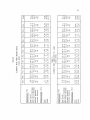
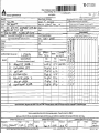
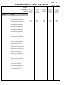
1
AIR QUALITY AND METEOROLOGY TECHNICAL DATA REPORT Sukunka Coal Mine Project Prepared for: Glencore 1285 West Pender Street, Suite 900 Vancouver, BC V6E 4B1 Attention: Bryan Tiedt Prepared by: Stantec Consulting Ltd. 4370 Dominion Street, Suite 500 Burnaby, BC V5G 4L7 Tel: (604) 436-3014 Fax: (604) 436-3752 Final 123110482 November 15, 2013 NOTE: Development of the baseline Technical Data Reports (TDRs) for the Project took place over a 20-month period. During this time the mine plan went through several iterations. Because of this, the mine plan shown in the TDR may be different then the plan in the environmental assessment Application. The key features that changed from the preliminary design include: • • • • • • • The underground mine from the environmental assessment was removed but appears in some TDRs. The life of mine and initial tailings storage facilities were removed and tailings will be co-disposed with the waste rock in stockpiles. Three new transport options were added near Tumbler Ridge. The three options have alternative load-out locations. Option C is no longer considered in the environmental assessment but appears in some of the TDRs. Three transmission line options were added. The waste rock stockpiles and open pits were refined. Water management features were added including a discharge and water collection pipe and collection and diversion ditches. A second location option for the coal handling and processing plant was added. AIR QUALITY AND METEOROLOGY TECHNICAL DATA REPORT AUTHORSHIP Daniel Jarratt, EP, P.Eng. Technical Review Mike Schroeder, B.Sc., M.Sc. Senior Review John Gallagher, M.Sc., B.S. Author Katelyn Wells, B.Sc. Author i AIR QUALITY AND METEOROLOGY TECHNICAL DATA REPORT Executive Summary Air quality has been selected as a valued component for environmental assessment of the Sukunka Coal Mine Project. To assess potential cumulative effects of the Project with other existing sources of air pollutants, representative background air quality values need to be developed. An understanding of the local meteorology is also required due to the importance of meteorological conditions on dispersion of air contaminants. To this end, a baseline ambient air quality and meteorology study was conducted for the Project area. This study incorporates historical and existing data and reports with results of a field data collection program that began in August 2012. The historical data available for the Sukunka project area are primarily from the 1970s when the mineral tenures were being explored by the Coal Division of BP Exploration Canada Limited. Information from regional weather stations is supplemented by data from an automated meteorological station in the Sukunka local study area (LSA) that was installed in September 2012. The station measures and records hourly observations of air temperature, relative humidity, wind speed and direction, total precipitation, snow depth, solar radiation, and atmospheric pressure. As particulate matter (PM) from fugitive dust is typically the contaminant of greatest concern for coal mining, the air quality baseline monitoring program focused on measurement of PM concentrations and dustfall (PM deposition). Two PM monitoring instruments in the Sukunka regional study area (RSA) recorded ambient concentration of respirable particulate matter (PM2.5). A network of six dustfall stations monitored deposition at various elevations in the study area where future infrastructure is proposed or along proposed mine access or coal hauling corridors. The dustfall containers are changed out monthly and sent to a certified lab for analysis. Preliminary results indicate that weather conditions in the study area are highly variable, with large day-to-day temperature swings being common, particularly in winter. This is due largely to the influence of the Rocky Mountains, which often form a boundary between disparate air masses. Temperatures at the Sukunka meteorological station show less diurnal range than those of the Chetwynd Airport and precipitation amounts are higher. These differences likely arise from the elevation difference between the two stations and the closer proximity to the mountains for the Sukunka site. Particulate monitoring data recorded at a site in the District of Chetwynd near the airport since November 2012 show that winter PM2.5 concentrations are generally low, with no readings in excess of BC Ambient Air Quality Objectives or Canada-Wide Standards for air quality. Temporal variability in PM concentrations can be explained by changing weather (and thus dispersion) conditions and variations in emissions from nearby industrial sources. Dustfall amounts are also ii AIR QUALITY AND METEOROLOGY TECHNICAL DATA REPORT low for the study period, with monthly results for all stations remaining well within the BC Pollution Control Objectives. Air quality and meteorology baseline data collection will continue until at least one year’s worth of valid data have been recorded. In addition, to comply with recommendations from the British Columbia Ministry of Environment (BC MOE), baseline data collected up to three months prior to the submission of the Environmental Assessment Certificate Application should be included. iii AIR QUALITY AND METEOROLOGY TECHNICAL DATA REPORT Table of Contents 1.0 INTRODUCTION ............................................................................................................. 1 2.0 REGIONAL SETTING ....................................................................................................... 2 3.0 3.1 3.2 STUDY AREAS ................................................................................................................. 3 REGIONAL STUDY AREA .................................................................................................... 3 LOCAL STUDY AREA .......................................................................................................... 3 4.0 4.1 BACKGROUND AND METHODS .................................................................................... 5 REVIEW OF EXISTING AIR QUALITY AND METEOROLOGICAL DATA SOURCES ........... 5 4.1.1 Preliminary Environmental Study of the Sukunka Coal Project (1975) ................................................................................................................ 5 4.1.2 Sukunka-Bullmoose Environmental Studies (1977–1979) ........................... 5 4.1.3 Chetwynd Windrem School Air Quality Data ............................................. 6 FIELD SURVEYS.................................................................................................................. 10 4.2.1 Meteorological Station ................................................................................ 10 4.2.2 Particulate Matter Monitoring .................................................................... 16 4.2.3 Dustfall Monitoring ........................................................................................ 18 4.2 5.0 5.1 5.2 5.3 6.0 6.1 RESULTS ........................................................................................................................ 21 METEOROLOGY ............................................................................................................... 21 5.1.1 Air Temperature ............................................................................................ 21 5.1.2 Precipitation .................................................................................................. 23 5.1.3 Wind Speed and Direction .......................................................................... 25 5.1.4 Solar Radiation .............................................................................................. 25 5.1.5 Snow Depth ................................................................................................... 25 5.1.6 Atmospheric Pressure ................................................................................... 25 PM CONCENTRATIONS ................................................................................................... 30 5.2.1 SHARP PM Monitor ........................................................................................ 30 5.2.2 GRIMM PM Monitor ...................................................................................... 31 DUSTFALL SAMPLES.......................................................................................................... 36 6.2 6.3 DISCUSSION ................................................................................................................ 39 METEOROLOGY ............................................................................................................... 39 6.1.1 Comparison to Chetwynd Airport .............................................................. 39 PARTICULATE MATTER ..................................................................................................... 40 DUSTFALL .......................................................................................................................... 41 7.0 RECOMMENDED MONITORING AND DATA COLLECTION ......................................... 42 8.0 8.1 REFERENCES................................................................................................................. 43 LITERATURE CITED ............................................................................................................ 43 9.0 CLOSING ..................................................................................................................... 44 v AIR QUALITY AND METEOROLOGY TECHNICAL DATA REPORT LIST OF TABLES Table 4.1-1 Table 4.1-2 Table 4.2-1 Table 4.2-2 Table 4.2-3 Table 4.2-4 Table 4.2-5 Table 4.2-6 Table 5.1-1 Table 5.2-1 Table 5.2-2 Table 5.3-1 Table 5.3-2 Table 6.1-1 Table 6.2-1 Analysis of Chetwynd Windrem School 24-Hour Average PM2.5 Measurements (2007 to 2009) Relative to the BC Ambient Air Quality Objectives and Canada-Wide Standards .................................... 7 Analysis of Chetwynd Windrem School 24-Hour AveragePM10 Measurements (2007 to 2009) Relative to the BC Ambient Air Quality Objectives and Canada-Wide Standards .................................... 7 Location of the Sukunka Meteorological Station .................................... 10 List of Sensors for the Sukunka Automated Meteorology Station .......... 11 Meteorology Data Quality Assurance Screening Criteria ...................... 15 Location of the SHARP and GRIMM Particulate Monitoring Instruments ..................................................................................................... 17 Sukunka Dustfall Station Locations ............................................................. 19 Dustfall Sample Container Change-Out Dates........................................ 20 Monthly Temperatures at the Sukunka Meteorology Station for September 2012 to April 2013 ..................................................................... 23 Frequency of SHARP 24-hour average PM2.5 Measurements Relative to the Provincial Objectives and Canada-Wide Standards ... 30 Frequency of GRIMM PM2.5 Measurements Relative to the Provincial Objectives and Canada-Wide Standards .............................. 32 Mean Total Dustfall at the Sukunka Dustfall Sites for August 2012 to April 2013........................................................................................................ 36 Total Metal Concentrations at the Sukunka Dustfall Monitoring Stations (mg/dm2/day) ................................................................................ 38 Sukunka Meteorology Station Data Compared to Observations and Climatological Normal from Chetwynd Airport ............................... 40 Comparison of SHARP and GRIMM Ambient Air Sampler Monthly Mean 24-Hour PM2.5 Measurements (µg/m3) ............................................ 40 LIST OF FIGURES Figure 3.1-1 Figure 4.1-1 Figure 4.1-2 Figure 4.2-1 Figure 5.1-1 Figure 5.1-2 Figure 5.1-3 vi Air Quality Regional Assessment Area ......................................................... 4 Variation in 24-Hour Average PM2.5 Concentrations at the Chetwynd Windrem School .......................................................................... 8 Variation in 24-Hour Average PM10 Concentrations at the Chetwynd Windrem School.............................................................................................. 9 Location of Air Quality and Meteorological Stations .............................. 12 Daily Average, Minimum, and Maximum Air Temperatures at the Sukunka Meteorology Station for September 2012 to April 2013........... 22 Total Accumulated Precipitation and Total Monthly Precipitation at the Sukunka Meteorology Station from October 2012 to March 2013 .................................................................................................... 24 Wind Roses and Frequency Diagrams at the Sukunka Meteorology Station for Summer (September 2012 and April 2013) and Winter (October 2012 to March 2013) ................................................................... 26 AIR QUALITY AND METEOROLOGY TECHNICAL DATA REPORT Figure 5.1-4 Figure 5.1-5 Figure 5.1-6 Figure 5.2-1 Figure 5.2-2 Figure 5.2-3 Figure 5.2-4 Figure 5.3-1 Daily Average Solar Radiation at the Sukunka Meteorology Station for September 2012 to March 2013 .............................................. 27 Daily Average Snow Depth at the Sukunka Meteorology Station for September 2012 to March 2013 .............................................. 28 Hourly Atmospheric Pressure Corrected to Mean Sea Level Pressure at the Sukunka Meteorology Station for September 19, 2012 to April 2, 2013 ...................................................................................... 29 Variation in 24-Hour Average PM2.5 Concentrations at the SHARP Particulate Monitor for November 2012 to March 2013 at District of Chetwynd ...................................................................................................... 31 Variation in 24-Hour Average PM2.5 Concentrations at the GRIMM Particulate Monitor for December 2012 to March 2013 at District of Chetwynd ...................................................................................................... 33 Variation in 24-Hour Average PM10 Concentrations at the GRIMM Particulate Monitor for December 2012 to March 2013 at District of Chetwynd ...................................................................................................... 34 Variation in 24-Hour Average TSP Concentrations at the GRIMM Particulate Monitor for December 2012 to March 2013 at District of Chetwynd ...................................................................................................... 35 Total Monthly Dustfall at the Sukunka Dustfall Monitoring Stations for September 2012 to April 2013 ..................................................................... 37 LIST OF PHOTOS Photo 4.2-1 Photo 4.2-2 Photo 4.2-3 Photo 4.2-4 Photo 4.2-5 Sukunka Automated Meteorology Station ............................................... 13 Campbell Scientific CR1000 Datalogger in a Fiberglass Weatherproof Enclosure .............................................................................. 14 GEONOR Precipitation Gauge with a Capacity of 1,500 mm............... 15 SHARP and GRIMM PM Monitors at the District of Chetwynd Monitoring Site .............................................................................................. 18 Dustfall Monitoring Station........................................................................... 19 LIST OF APPENDICES Appendix A Appendix B Appendix C Appendix D Appendix E Appendix F Historical Documents ..................................................................................A.1 Description of Dustfall Sites ......................................................................... B.1 Sharp and GRIMM PM Monitor Time Series ............................................. C.1 Dustfall Lab Reports .....................................................................................D.1 SHARP Leak Check and Flow Audit .......................................................... E.1 GRIMM Calibration Certificates..................................................................F.1 vii AIR QUALITY AND METEOROLOGY TECHNICAL DATA REPORT Abbreviations µg/m3 micrograms per cubic metre BC British Columbia cm centimetre km kilometre LSA local study area m metre m/s metre per second mb millibar mg/dm2/day milligrams per square decimetre per day MOE Ministry of Environment PM particulate matter PM10 inhalable particulate matter less than 10 micrometres in diameter PM2.5 respirable particulate matter less than 2.5 micrometres in diameter QA/QC quality assurance/quality control RSA regional study area TSP total suspended particulate W/m2 watts per meter squared ix AIR QUALITY AND METEOROLOGY TECHNICAL DATA REPORT Introduction November 15, 2013 1.0 Introduction Mining activities can release fugitive dust and gaseous emissions from combustion to the atmosphere. The atmosphere is an important environmental pathway for the transport of contaminants from emissions sources to receptors. The level of contaminants in the air or the “quality” of the air can affect the health and well-being of humans, wildlife, vegetation, and other biota. Therefore, air quality has been selected as a valued component for this assessment. The air contaminant of greatest concern associated with a coal mining is usually particulate matter (PM), which is defined in terms of size fractions. Particulate of all size classes is referred to as total suspended particulate (TSP), while particulate less than 10 micrometres (μm) in diameter is PM10, and particulate with diameters less than 2.5 μm is PM2.5. The smaller particles are generally thought to be of greater concern to human health than the larger particles because of their ability to penetrate further into the lungs. Dustfall refers to the amount of TSP that is deposited onto a collection surface in a given amount of time. Dustfall has the potential to negatively impact water bodies by increasing the sediment load and also causes accumulation of dust that can be a nuisance. Other air emissions of concern from mines includes nitrogen dioxide and sulphur dioxide, which have the potential to affect human and wildlife health, as well as vegetation. Emissions of greenhouse gases are also of concern for their potential contribution to global climate change. Meteorological conditions greatly affect the extent to which air pollutants are dispersed after leaving their source locations. Therefore, an understanding of the local meteorology of the study area is important to the assessment of potential air quality effects. Baseline ambient air quality conditions are characterized by collecting meteorological and air quality observations for approximately one year to develop representative background air quality values and determine seasonal variations. The background values take into account existing sources of air pollutants in the airshed and thus represent one component of a cumulative effects assessment. 1 AIR QUALITY AND METEOROLOGY TECHNICAL DATA REPORT Regional Setting November 15, 2013 2.0 Regional Setting The Sukunka property is located in the Rocky Mountain Inner Foothills physiographic region and is characterized by relatively low, rounded, northwest-southeast trending ridges and valleys, ranging from approximately 1,000 to 2,000 metres (m) in elevation. The property is predominantly forested with stands of lodgepole pine and occasional spruce, with stands of balsam poplar occurring in the lower and wetter areas of the tenure area. The climate of the region is classified as northern temperate. Daily mean temperatures at the Chetwynd Airport range from −10.7°C in January to 15.3°C in July. Extreme air temperatures range from −52 to 34°C. The average annual precipitation at Chetwynd is 448 millimetres (mm), which includes the rainfall equivalent of a mean snowfall of 170 centimetres (cm). The region does not have distinct wet and dry seasons, although the summer months usually have more precipitation than the winter months. February is normally the driest month of the year and July is the wettest month. Local air flow is strongly influenced by valleys and other terrain features, and by larger terrain influences on the upper level wind patterns. Strong temperature differences may occur between valley floors and nearby elevated terrain features. The local terrain influences will affect the transport and dispersion of contaminants emitted into the atmosphere. In addition, local ground cover will also have an effect on the dispersion and deposition of these emissions. There has been forestry, oil and gas, and some mining activity in the area of the Sukunka Project; however, there are no known, currently operating, large sources of emissions within 10 km of the Sukunka project tenure area. There are also no known residences within 10 km of the proposed mine site. 2 AIR QUALITY AND METEOROLOGY TECHNICAL DATA REPORT Study Areas November 15, 2013 3.0 Study Areas 3.1 REGIONAL STUDY AREA The Sukunka air quality regional study area (RSA) is an 80 by 80 km area, as illustrated Figure 3.1-1. It encompasses the Sukunka air quality local study area (LSA) as well as a minimum 5 km buffer around all rail, conveyor and road options for transporting the washed coal to the nearest existing infrastructure location. The air quality RSA will be used as the basis for the criteria air contaminant and greenhouse gas emission inventory for all project components and it will be used to assess cumulative effects in the Environmental Assessment Certificate Application. 3.2 LOCAL STUDY AREA The air quality LSA is a 36 by 36-km area centered on the Sukunka project tenure area, as shown in Figure 3.1-1. This area includes a 10-km buffer on all sides of the Sukunka tenure. This size of study area should be sufficient to delineate potential project effects down to background levels. The air quality LSA will be used to conduct dispersion modelling of the main sources of emissions from the proposed Sukunka Project including the open pit(s), underground mine, coal handling and preparation plant, and the load-out. 3 ! ! ! ! p ! ! ! ! ! 575000 !! ! 600000 ! ! !!!! ! ! ! ! ! River !! ! Peac e ! ! r be Mo Grave yard ! ! ! 6200000 ! ! ! ! ! ! ! ! ! ! 625000 ! ! ! Creek ! ! ! ! ! ! ! Johnson Creek ± r i ve ly R ! ! ! ive Pine R r ! ! ! Stewart Creek 550000 6200000 ! ! ! ! ! ! ss Cre ek Hu lcro ! ! ! ! ! Caron Creek ! ! ! ! ! 29 £ ¤ ! ! ! gC re ek ! Fa llin Ri ve r k ee ! ek ! ! Cre ! ! ray ! ! n otio ! ! r ive ! ! ! ! ! ! Cr ee k ! ! CNRL Pipeline tin ! Ha sle 6150000 Ma r ! rC re e k ! !!! tR hha Hig ! GWILLIM LAKE PARK ! ! ! ! Salt C Gwillim Lake ! ! ! ! ! ! ! ! ! ! ! ! ! ! ! ! ! ! ! ! ! ! 6125000 ! ! ! ! SUKUNKA FALLS PARK 6125000 Burnt River reek Gwillim River ! ! ! ! ! Brazion Creek ! ! ! ! ! ! ! ! ! ! ! ! ! ! ! ! ! ! ! ! ! ! iver aR unk Suk Tumbler Ridge ! ! HOLE IN THE WALL PARK eek ! Wi nd fal lC re e k F!latb! ed C r ! ! 6100000 ! 6100000 ! ! ! ! ! ! Anza c 0 5 10 15 550000 Hook C reek 575000 600000 Transportation Options City / Town / Village ! Pipeline ! ! Transmission Line Watercourse First Nations Reserve Option A Provincial Park Option B Local Assessment Area Option D Road Railway 625000 SUKUNKA COAL MINE PROJECT Legend Airport Cre e 20 km 1:375,000 p C re ek ock Tent fire Bab c Rive r k ! Barb our C reek ! £ ¤ ! m Com ! eek 97 ! ! ! ! Mu r ! Biss ett C r 6150000 ! ! ! ! ! PINE RIVER BREAKS PARK ! ! 6175000 ! ! ! EAST PINE PARK 97 £ ¤ p ! ! k ee Cr C ! ! ! ! ek ! ! ! Chetwynd ion tur ! en 6175000 ! ! ! ! ! ek Cre ep e h S ! eshi Cre Shangw ! ! ! ! Cowie Cr ! ! ! ! ! ! EAST MOBERLY MOBERLY LAKE 169 LAKE PARK ! ! ! ! ! ! WEST MOBERLY LAKE 168A ! ! ! ! M ! ! rly Lake obe ! !! ! ! ! ! ! ! ! Regional Assessment Area PREPARED BY: AIR QUALITY LOCAL AND REGIONAL ASSESSMENT AREA PREPARED FOR: TECHNICAL DATA REPORT - AIR QUALITY ! ! Option 1 ! ! Option 2 Data Sources: Glencore, Province of British Columbia, Government of Canada Disclaimer: Although there is no reason to believe that there are any errors associated with the data used to generate this product or in the product itself, users of these data are advised that errors in the data may be present. File Path: fig_10482_tdr_air_quality_03_01-01_air_quality_local_and_regional_assessment_areas ! ! Option 3 DATE: Option E Transmission Line Options Sukunka Project Tenure Area 15-AUG-14 FIGURE ID: 123110482 PROJECTION: UTM 10 DRAWN BY: DATUM: CHECKED BY: D. JARRETT NAD 83 D. COOK FIGURE NO: 3.1-1 AIR QUALITY AND METEOROLOGY TECHNICAL DATA REPORT Background and Methods November 15, 2013 4.0 Background and Methods 4.1 REVIEW OF EXISTING AIR QUALITY AND METEOROLOGICAL DATA SOURCES A number of historical data sources describing the regional air quality and meteorological conditions are available. Appendix A contains the historical documents that are summarized in the following sections. 4.1.1 Preliminary Environmental Study of the Sukunka Coal Project (1975) The report Preliminary Environmental Study of the Sukunka Coal Project (BC Research 1975) summarized meteorological data from 1971 to 1975. Air temperature and precipitation observations were recorded near the mine site at a weather station known as Chetwynd Sukunka. Only the years 1972–1974 had complete data records. These observations were supplemented by 1941–1970 Environment Canada climate data from Dawson Creek and Fort St. John. During 1972–1974, the mean daily air temperature at the historical Chetwynd Sukunka site was –0.7°C, and ranged from –4.2°C (1974) to 1.5°C (1973). The average daily maximum over the 3-year period was 7.4°C and the average daily minimum was -5.0°C. Data from the Dawson Creek and Fort St. John stations indicated that during the 1941–1970 period the extreme minimum temperature was –48°C and the extreme maximum temperature was 33°C. Annual precipitation at the Chetwynd Sukunka station averaged 689 mm during the three years with complete data. Annual snowfall ranged from 230 cm in 1973 to 487 cm in 1972. Wind speed and direction were not measured at the weather station, but the prevailing wind was inferred by human observations to be from the southwest (down the Sukunka River Valley). Relevant tables and figures from this report are included in Appendix A. 4.1.2 Sukunka-Bullmoose Environmental Studies (1977–1979) The report Sukunka-Bullmoose Stage I Environmental Study (BP Exploration Canada 1977) included a section describing the climate of the study area, which was compiled based on data from long-term climatological stations at Dawson Creek, Fort St. John, and Prince George as well as shorter data records from Chetwynd Sukunka, Bullmoose, and several other stations in the region. The report outlined regional temperature, precipitation, wind, and inversion characteristics. It was noted that insufficient data were available to evaluate air quality, but a relatively pristine condition was assumed due to the undeveloped state of the study area. 5 AIR QUALITY AND METEOROLOGY TECHNICAL DATA REPORT Background and Methods November 15, 2013 The Sukunka-Bullmoose Stage 1 study highlighted climatological differences between the study area and the long-term stations, which result from differences in elevation and proximity to the Rocky Mountains. The mean annual temperature at Chetwynd Sukunka (-0.7°C) was noted to be about 2°C colder than Dawson Creek and Fort St. John. Precipitation at Chetwynd Sukunka was found to be considerably higher than that of Dawson Creek and Fort St. John, with maximum daily amounts estimated to be about 80 mm. The mean total annual precipitation amounts for Chetwynd Sukunka, Dawson Creek and Fort St. John were 690, 425 and 450 mm, respectively. Temperature inversions in the Chetwynd area were observed on 60-80 percent of days year-round during the overnight and early morning hours, and on nearly half (45 percent) of winter days in the afternoon hours. In 1979 the Sukunka Coal Project Stage II Submission was prepared for the BC Environment and Land Use Committee (BP Exploration Canada 1979). This report summarized the anticipated environmental effects of the proposed underground coal mine. A network of six dustfall stations and one particulate monitoring station in the Sukunka Valley was referred to in the Stage II report, but no results were presented. Dust control along the Sukunka Forestry Road was cited as an issue of concern. Relevant tables and figures from the Stage I report are included in Appendix A. 4.1.3 Chetwynd Windrem School Air Quality Data Particulate matter (PM) monitoring was conducted by the British Columbia Ministry of Environment (BC MOE) at the Chetwynd Windrem Elementary School periodically from 2007 through 2009. Data gaps exist, but in general both inhalable (PM10) and respirable (PM2.5) particulate concentrations were sampled every three days. Months with less than three days of PM2.5 data include September 2007, January 2008, February 2008 (no data), March 2008, May 2008, July 2008 (no data), and August 2008. All of the available months of PM10 data have more than four days with reliable data. The maximum PM2.5 concentration was 21 micrograms per cubic metre (µg/m3) and the maximum PM10 concentration was 80 µg/m3 (both are 24-hour averages). Table 4.1-1 and Table 4.1-2 compare the BC Ambient Air Quality Objectives (25 µg/m3 for PM2.5 and 50 µg/m3 for PM10) and the Canada-Wide Standards (30 µg/m3 for PM2.5). This comparison shows that none of the observed PM2.5 concentrations exceeded the provincial objective or Canada-Wide Standard. Concentrations of PM2.5 greater than half the provincial objective occurred 1.2 percent of the time. Table 4.1-2 shows that 24-hour average PM10 concentrations exceeded the provincial objective 1.4 percent of the time and were more than half the provincial objective for 9.2 percent of observations. 6 AIR QUALITY AND METEOROLOGY TECHNICAL DATA REPORT Background and Methods November 15, 2013 Table 4.1-1 Analysis of Chetwynd Windrem School 24-Hour Average PM2.5 Measurements (2007 to 2009) Relative to the BC Ambient Air Quality Objectives and Canada-Wide Standards Parameter Total number of data records Count of data records > 12.5 Frequency > 12.5 Frequency > 25 171 µg/m3 (half of BC Objective) µg/m3 Count of data records > 25 PM2.5 2 1.2% µg/m3 (BC Objective) µg/m3 0 0.0% Count of data records > 15 µg/m3 (half of Canada-Wide Standard) 2 Frequency > 15 µg/m3 1.2% Count of data records > 30 µg/m3 (Canada-Wide Standard) 0 Table 4.1-2 Analysis of Chetwynd Windrem School 24-Hour AveragePM10 Measurements (2007 to 2009) Relative to the BC Ambient Air Quality Objectives and Canada-Wide Standards Parameter Total number of data records Count of data records > 25 µg/m3 ( half of BC Objective) PM10 207 19 Frequency > 25 µg/m3 9.2% Count of data records > 50 µg/m3 (BC Objective) 3 Frequency > 50 µg/m3 1.4% Box and whisker plots (Figure 4.1-1 and Figure 4.1-2) illustrate the monthly variation of the daily PM2.5 and PM10 concentrations observed at the Windrem School in Chetwynd. The interquartile range (25th to 75th percentile) is illustrated by the box’s bottom and top. The median is represented by the line through the centre of the box. The vertical lines (whiskers) indicate the maximum and minimum daily concentrations during that month. Months where there were three or less days with reliable data do not have whiskers extending from the boxes. 7 AIR QUALITY AND METEOROLOGY TECHNICAL DATA REPORT Background and Methods November 15, 2013 Figure 4.1-1 Variation in 24-Hour Average PM2.5 Concentrations at the Chetwynd Windrem School 8 AIR QUALITY AND METEOROLOGY TECHNICAL DATA REPORT Background and Methods November 15, 2013 Figure 4.1-2 Variation in 24-Hour Average PM10 Concentrations at the Chetwynd Windrem School 9 AIR QUALITY AND METEOROLOGY TECHNICAL DATA REPORT Background and Methods November 15, 2013 4.2 FIELD SURVEYS Due to the dated nature of previous environmental studies in the Sukunka Valley and limited data availability, a baseline monitoring program was implemented in 2012 with the deployment of new meteorological, particulate, and dustfall monitoring stations in the Sukunka LSA and RSA. The locations of these stations are shown in Figure 4.2-1. Details of the instruments and measured parameters are provided below. Based on the remote location of the proposed Sukunka Project and a relatively low level of anthropogenic activities, it is not deemed necessary to carry out baseline monitoring of nitrogen dioxide and sulphur dioxide ambient concentrations. The monitoring program focused on particulate matter, including dustfall. 4.2.1 Meteorological Station The Sukunka meteorological station is located near kilometre 32 of the Sukunka Forest Service Road, approximately 51 km south of Chetwynd (Figure 4.2-1, Table 4.2-1, Photo 4.2-1). The station consists of a 10-m aluminum tower, meteorological instruments, datalogger, high definition camera, satellite modem, and power system (solar and battery). The station measures and records wind speed and direction, air temperature, relative humidity, snow depth, total precipitation, solar radiation, and atmospheric pressure. The location for the Sukunka automated meteorology station followed guidance provided in the MSC Guidelines for Co-operative Climatological Autostations Version 3.0 (Environment Canada 2004) and the Guidelines for Air Quality Dispersion Modelling in British Columbia (BC MOE 2008). A suitable site was confirmed during a reconnaissance field trip and after consultation with the Glencore mine planning engineers about the proposed locations for future mine infrastructure. Coordinates of the station are provided in Table 4.2-1. The station is situated in a nearly level clearing in the Sukunka Valley, just south of Skeeter Creek. Table 4.2-1 Location of the Sukunka Meteorological Station UTM (NAD 83 Zone 10) Easting (m) Northing (m) 585,734 6,122,327 Elevation (m) 757 Data Available September 19, 2012–present Table 4.2-2 describes the sensors installed at the Sukunka meteorological station. The Campbell Scientific CR1000 datalogger records data on an hourly basis; these observations, including lower resolution photos from the digital camera, are automatically downloaded once per day via satellite modem. The high resolution photos are downloaded manually during site visits. Photo 4.2-1, Photo 4.2-2, and Photo 4.2-3 show the meteorological station, the datalogger enclosure, and the precipitation gauge. 10 AIR QUALITY AND METEOROLOGY TECHNICAL DATA REPORT Background and Methods November 15, 2013 Table 4.2-2 Parameter List of Sensors for the Sukunka Automated Meteorology Station Sensor Manufacturer Model Number Serial Number Mounting Height (m) Datalogger Measurement and Control Module with 4MB Ram Memory Campbell Scientific CR100055 50281 2 Solar Panel 50 Watt 12 Volt Campbell Scientific MSX50R-L D31203059D755DD 5 Solar Radiation Pyranometer Sensor w/ Integrated Leveling Kipp & Zonen CMP3-L 127273 6 Wind Speed Wind Direction Wind Monitor-AQ RM Young 05305-10-L 119478 10 Relative Humidity Air Temperature Relative humidity Probe (0 to 100%) Temperature Probe (-50 to +50C) Campbell Scientific HC2-S3-L 60947447 3 Pressure Barometric Pressure Sensor 500 –1100 millibars (mb) Vaisala PTB110 H1460091 1 Precipitation Precipitation Gauge–1500 mm GEONOR T-200B-MD 30412 3 (12 m away from met tower) Snow Depth Sonic Ranger Campbell Scientific SR50A 4676 5 11 ! ! ! ! ! ! ! ! ! ! 570000 580000 590000 600000 610000 620000 ± ! ! ! ! ! 560000 ! Pin e River ! 6190000 ! ! oa d ! !! ! ! ! ! ke ! ! ! y wa gh i H ! ! ! 6180000 La ! ! ! sh ! ! WEST MOBERLY LAKE 168A ! ! ! ! Moberly Lake Park ! ! ! ! EAST MOBERLY !LAKE 169 ! ! Lake Morberly R ! ! ! ! ! ! ! Jackf i ! ! ! ! ! Highwa y !29 ! ! 97 6180000 ! ! ! ! 6190000 ! ! ! 550000 ! ! ! ! ! ! 6170000 h o ut ! ( ( ! ! 97 ! Pine River Breaks Park 16 ! ay gh w ! ! ! ! ! ! Hi ! ! ! 97 ! ! ir ie Roa d Lone P ra ! 6160000 6160000 ! ! ! ! ! ! ! ! Dic k ! ! ! eb u ek 6150000 ek gh Cr e re ! H!i ! 6150000 hC ! sc wa ! 2 !9 H a sl er y ! ! ! r Cr 6140000 R iv e r ! ! Lake Gwillim ! 13 ! 6130000 ! Sukunka Falls Park 6130000 ( ! reek ! Bullmoose 1181120 ! ( d a o ! ! ! B ullm e Cre ek ! ! ! ! ! ! ( ! ! 12 ( ! ( ! ! ! ! ! ! Tumbler Ridge 1188297 ! Hole In The Wall Park ! ! Tumbler Ridge ! ! 6110000 o os ! k ee Cr llm ! ! n erlai r ( ! Ro ! mb ive 14 11 e os 6120000 ! Ch a tR rn 6120000 ! ( ( ! ! Chetwynd Sukunka ! Bu Skeeter C r eek 9 ! R ! yC oc k er ! B u r n t Riv ! No rt h Sukunka FSR Sukunka FSR ! W in d 6110000 6140000 l im k ee r e ek ld e ! Bou il C ! d Gw in Cr ee k ! reek ! ff C zion C Bl Br a Gwillim Lake Park ! Blu Br us h re ek Bu fa lC ! l re ek ! ! 6100000 ! 6100000 ! ! ! ! ! ! ! ! ! 6090000 Ri ve r 6090000 Su ku nk a ! ! ! ! ! ay H i ghw Pine River ! ! ! ! ! ! S ! ! ! Chetwynd Airport 1181508 6170000 ! ! ! ! East Pine Park Chetwynd 0 5 10 15 20 km 1:325,000 550000 560000 570000 580000 590000 Historical Meteorological Station ( ! Environment Canada Meteorology Station ! ( ( ! ( ! 610000 620000 SUKUNKA COAL MINE PROJECT Legend ( ! 600000 City / Town / Village ! Railway Road Dustfall Station Meteorology and Dustfall Station Particulate (TSP/PM10/PM2.5) and Dustfall Station ! ! First Nations Reserve Provincial Park Option A Pipeline Option B Transmission Line Option C Local Study Area Sukunka Project Tenure Area LOCATION OF AIR QUALITY AND METEOROLOGICAL MONITORING SITES TECHNICAL DATA REPORT - AIR QUALITY Haulage Options Watercourse Option D Option E PREPARED BY: Data Sources: Glencore, Province of British Columbia, Government of Canada Disclaimer: Although there is no reason to believe that there are any errors associated with the data used to generate this product or in the product itself, users of these data are advised that errors in the data may be present. File Path: fig_10482_tdr_air_quality_04_02-01_location_of_air_quality_and_meteorological_stations DATE: 24-OCT-13 FIGURE ID: 123110482 PROJECTION: UTM 10 DRAWN BY: DATUM: CHECKED BY: D. JARRATT NAD 83 D. COOK PREPARED FOR: FIGURE NO: 4.2-1 AIR QUALITY AND METEOROLOGY TECHNICAL DATA REPORT Background and Methods November 15, 2013 Photo 4.2-1 Sukunka Automated Meteorology Station 13 AIR QUALITY AND METEOROLOGY TECHNICAL DATA REPORT Background and Methods November 15, 2013 Photo 4.2-2 14 Campbell Scientific CR1000 Datalogger in a Fiberglass Weatherproof Enclosure AIR QUALITY AND METEOROLOGY TECHNICAL DATA REPORT Background and Methods November 15, 2013 Photo 4.2-3 GEONOR Precipitation Gauge with a Capacity of 1,500 mm Data downloaded from the station are assessed with a quality assurance and quality control (QA/QC) process. Methods for completing the QA/QC review of data are derived from the MSC Guidelines for Co-operative Climatological Autostations Version 3.0 (Environment Canada 2004), as well as Meteorological Monitoring Guidance for Regulatory Modeling Applications (US EPA 2000) and professional judgment. The raw hourly data are checked using the screening process outlined in Table 4.2-3. Observations that do not meet the screening criteria are flagged for removal from calculations of averages and extremes. Data collection commenced on September 19, 2012 for all sensors except the GEONOR precipitation gauge, which was installed on October 23, 2012. For the current analysis, the period of valid data is from September 19, 2012 to April 2, 2013 for all sensors except the GEONOR precipitation gauge, which has valid data from October 23, 2012 to April 2, 2013. Table 4.2-3 Meteorology Data Quality Assurance Screening Criteria Parameter Air Temperature Screening Criteria • • If the same value is read for 10 or more consecutive hours If minimum temperature is greater than maximum temperature 15 AIR QUALITY AND METEOROLOGY TECHNICAL DATA REPORT Background and Methods November 15, 2013 Table 4.2-3 Meteorology Data Quality Assurance Screening Criteria Parameter Precipitation Screening Criteria • • • • If hourly accumulated liquid precipitation is greater than 89.9 mm If hourly accumulated liquid precipitation is non-zero and if it is the same as that of the two preceding hours If the hourly precipitation is negative If the precipitation calculated from first principles (e.g., using the manufacturer’s formula from the sensor calibration data sheet) does not match data Wind Speed and Direction • • If wind direction and speed are both zero for 24 or more consecutive hours If the same speed or direction value is read for 12 or more consecutive hours Snow Depth • • • • Between December and April, if more than 500 cm Between May and November, if more than 150 cm If the Signal Quality for the sonic ranger sensor (SR50A) is greater than 230 or less than 152 If the snow depth is negative Solar Radiation • • If daytime or summertime radiation is greater than nighttime or winter If nighttime solar radiation is greater than 0 Relative Humidity • If greater than 100% or less than 5% Since installation of the Sukunka meteorological station, there have been four datalogger program changes. The four changes are as follows: • • • Header lines updated on October 4, 2012 Signal quality, sample precipitation level, average precipitation frequency, sample precipitation frequency, and pressure added to the data output on October 23, 2012 Sample precipitation level, average precipitation frequency, and sample precipitation frequency were removed and average five-minute precipitation level was added on January 7, 2013 4.2.2 Particulate Matter Monitoring Ambient PM concentrations are being monitored by automated instrumentation at a District of Chetwynd site approximately 400 m south of the Chetwynd airport. These observations are for the purpose of recording baseline PM conditions near Chetwynd, which is part of the Sukunka air quality RSA. Two instruments are currently operating at the District of Chetwynd site: a Thermo Scientific SHARP Model 5030i particulate monitor and a GRIMM Aerosol Environ Check 365 unit. Location information for the instruments is provided in Figure 4.2-1 and Table 4.2-4. The GRIMM instrument will be moved to a location within the Sukunka air quality LSA when a suitable site with continuous AC power becomes available (the ongoing mineral exploration drilling program does not include an on-site camp with a power generator). The SHARP 5030i PM monitor was installed at the District of Chetwynd site on October 7, 2012. Due to considerable noise in the data and instrument calibration during the first month of monitoring, valid SHARP readings are considered to range from November 4, 2012 to March 26, 16 AIR QUALITY AND METEOROLOGY TECHNICAL DATA REPORT Background and Methods November 15, 2013 2013. The SHARP unit is a hybrid instrument that uses both the light scattering photometry of a nephelometer and a beta attenuation mass sensor to provide accurate continuous PM monitoring. As only one size fraction can be sampled at a time, the instrument has been configured to measure PM2.5, which is generally of greater concern from a human health perspective than larger size fractions, due to the respirable nature of very fine particulates. The inlet flow rate of the SHARP monitor is 16.67 liters per minute as ambient air containing PM is drawn through a heated sample tube. The heating system is used to maintain the relative humidity at or below a threshold setting of 35 percent. The system combines the short-term sensitivity of a nephelometer with the time-averaged accuracy of a beta attenuation sensor. PM2.5 concentrations are output as “NEPH”, “PM”, and “SHARP”, which are the nephelometer, beta attenuation, and hybrid values, respectively (Thermo Fisher Scientific 2011). Data analysis focuses on the hybrid “SHARP” readings, which are expected to be the most accurate observations of 24-hour average PM2.5 concentrations. The SHARP instrument also measures and records both ambient and sample relative humidity, temperature, and pressure. Ambient readings are used for volumetric flow rate regulation. A leak check and flow audit calibration were conducted during installation of the SHARP instrument. The following instrument quality assurance checks were also conducted during installation following the manufacturer’s recommendations: a) ambient temperature, b) flow temperature, c) barometric pressure, d) mass calibration, and e) nephelometer calibration for temperature and source level. Appendix E contains leak check and flow audit information from the SHARP user’s manual. The GRIMM Environ Check 365 instrument was moved from the Suska Exploration Camp to the District of Chetwynd site on December 12, 2012 and monitoring resumed on December 13, 2012. As the Suska camp was being dismantled (resulting in loss of continuous AC power for the GRIMM), it was decided that the instrument should be co-located with the SHARP monitor for a period of time sufficient to perform a comparison of the two instruments before deploying the GRIMM monitor in the Sukunka air quality LSA. The GRIMM instrument was calibrated by the manufacturer on August 9, 2012 and the calibration certificate is in Appendix F. Table 4.2-4 Location of the SHARP and GRIMM Particulate Monitoring Instruments PM Monitor UTM (NAD 83 Zone 10) Elevation (m) Valid Data Available Easting (m) Northing (m) Thermo SHARP 5030i PM2.5 monitor 586,286 6,171,480 615 November 4, 2012–present GRIMM PM monitor 586,286 6,171,480 615 December 13, 2012–present The GRIMM monitor is an aerosol spectrometer that uses a laser diode as a light source. The light scattering pulse of each particle passing through the detection chamber is counted and the 17 AIR QUALITY AND METEOROLOGY TECHNICAL DATA REPORT Background and Methods November 15, 2013 intensity of the scattered signal is correlated to a certain particle size range (GRIMM Aerosol Technik 2009). Thus, the instrument is able to simultaneously measure PM2.5, PM10, and Total Suspended Particulate (TSP). Like the SHARP unit, the GRIMM also monitors temperature, relative humidity, and barometer pressure. Photo 4.2-4 shows the SHARP and GRIMM instruments located next to each other at the District of Chetwynd monitoring site. The SHARP electronics are housed in the large white enclosure on the left, while the GRIMM is in the silver enclosure to the right. Photo 4.2-4 4.2.3 SHARP and GRIMM PM Monitors at the District of Chetwynd Monitoring Site Dustfall Monitoring Deposition of atmospheric PM is being measured by a network of dustfall canisters deployed throughout the study area. For the Sukunka baseline monitoring program, five dustfall stations were installed in the LSA and one additional dustfall station was installed at the District of Chetwynd site in the RSA. (Originally, a sixth station was installed at a high elevation site within 18 AIR QUALITY AND METEOROLOGY TECHNICAL DATA REPORT Background and Methods November 15, 2013 the LSA, but this station was vandalized within one month of installation.) Locations of these stations are provided in Figure 4.2-1 and Table 4.2-5. The five dustfall stations in the LSA were installed in August 2012 and the District of Chetwynd station was installed in October 2012. Locations were chosen following guidance provided in the Water and Air Baseline Monitoring Guidance Document for Mine Proponents and Operators (BC MOE 2012) and station configuration, equipment installation and siting followed the Standard Test Method for Collection and Measurement of Dustfall (Settleable Particulate Matter) (ASTM 2004). The dustfall stations each consist of two stands composed of metal poles topped by plastic wind screens to house the containers, which are open 12.5 cm diameter high density polyethylene plastic containers (Photo 4.2-5). Bird spikes are installed around the perimeter of the wind screen to prevent birds from fouling into the sample container. Table 4.2-5 Sukunka Dustfall Station Locations Station Name UTM (NAD 83 Zone 10) Easting (m) Northing (m) Elevation (m) 09 Skeeter Creek 585,733 6,122,328 752 11 Chamberlain Creek 591,096 6,115,555 1,658 12 Bullmoose Creek 594,604 6,110,538 1,205 13 Sukunka River 581,450 6,132,676 705 14 Windfall Creek 576,660 6,114,122 726 16 District Of Chetwynd 586,286 6,171,480 615 Photo 4.2-5 Dustfall Monitoring Station 19 AIR QUALITY AND METEOROLOGY TECHNICAL DATA REPORT Background and Methods November 15, 2013 Collection of the samples occurs monthly in order to obtain data that can be compared to the BC Pollution Control Objectives, which are based on monthly average deposition rates (BC MOE 1979). Actual container change-out dates are shown in Table 4.2-6. The dustfall containers at Site 11, Chamberlain Creek, were not collected during the late January/early February field trip due to site inaccessibility (unsafe helicopter flying conditions); therefore, data from the late February container change-out represent a two-month dustfall sample. Monthly dustfall samples are shipped to a certified lab for analysis of total dustfall, soluble dustfall, and insoluble dustfall in units of milligrams per square decimetre per day (mg/dm2/day). Additionally, a second dustfall canister is deployed at each station for metals analysis on a quarterly basis. The metals analysis provides the deposition rates (mg/dm2/day) of 28 different elements, including those expected to be of greatest interest to ecological and human health risk assessments (e.g., aluminum, arsenic, cadmium, copper, lead, molybdenum, nickel, selenium, silver, vanadium and zinc). Table 4.2-6 Dustfall Sample Container Change-Out Dates Station Name Sample Out Date (DD-MMM-YY) 09 Skeeter Creek 17-Sep-12 21-Oct-12 23-Nov-12 03-Jan-13 31-Jan-13 01-Mar-13 26-Mar-13 11 Chamberlain Creek 19-Sep-12 23-Oct-12 24-Nov-12 05-Jan-13 – 27-Feb-13 27-Mar-13 12 Bullmoose Creek 19-Sep-12 21-Oct-12 24-Nov-12 05-Jan-13 01-Feb-13 27-Feb-13 27-Mar-13 13 Sukunka River 17-Sep-12 21-Oct-12 23-Nov-12 03-Jan-13 31-Jan-13 01-Mar-13 27-Mar-13 14 Windfall Creek 17-Sep-12 21-Oct-12 23-Nov-12 03-Jan-13 01-Feb-13 27-Feb-13 27-Mar-13 – – 21-Nov-12 03-Jan-13 30-Jan-13 26-Feb-13 27-Mar-13 16 District Of Chetwynd 20 AIR QUALITY AND METEOROLOGY TECHNICAL DATA REPORT Results November 15, 2013 5.0 Results The following sections describe meteorology and air quality data collected at the Sukunka meteorology station, the SHARP and GRIMM PM monitors, and the six dustfall stations. Meteorological data records from September 19, 2012 to April 2, 2013 are included in the analysis. (Precipitation and atmospheric pressure records began on October 23, 2012.) SHARP PM2.5 concentration data range from November 4, 2012 to March 26, 2013. Project-relevant GRIMM PM concentration data are from December 2012 to March 2013. 5.1 METEOROLOGY Hourly data have been collected and processed from the Sukunka automated meteorology station as described in Section 4.2.1. The following sections summarize air temperature, precipitation, wind speed and direction, solar radiation, snow depth, and atmospheric pressure data from the station. A comparison to data from the Chetwynd Airport weather station (operated by Environment Canada–Meteorological Services of Canada) is also included. 5.1.1 Air Temperature Figure 5.1-1 shows daily average, minimum and maximum air temperatures for September 19, 2012 to April 2, 2013. Table 5.1-1 includes the overall maximum and minimum air temperatures during the sample period. The extreme maximum temperature during the period was 28.5°C (hour 16 September 23, 2012) and the extreme minimum was –31.2°C (hour 7 December 27, 2012). The hourly average air temperature for the available data ranged from –30.6°C (December 26, 2012) to 27.9°C (September 23, 2012). The overall average temperature for the sample period was –4.6°C 21 AIR QUALITY AND METEOROLOGY TECHNICAL DATA REPORT Results November 15, 2013 Figure 5.1-1 Daily Average, Minimum, and Maximum Air Temperatures at the Sukunka Meteorology Station for September 2012 to April 2013 22 AIR QUALITY AND METEOROLOGY TECHNICAL DATA REPORT Results November 15, 2013 Table 5.1-1 Month Monthly Temperatures at the Sukunka Meteorology Station for September 2012 to April 2013 Average Air Temperature (°C) Extreme Maximum Air Temperature (°C) Extreme Minimum Air Temperature (°C) Mean Maximum Air Temperature (°C) Mean Minimum Air Temperature (°C) September 2012 12.8 28.5 0.7 22.0 5.1 October 2012 –0.7 20.2 –20.5 4.0 –4.1 November 2012 –8.7 11.5 –24.4 –4.0 –12.5 December 2012 –14.1 2.2 –31.2 –10.3 –18.4 January 2013 –6.5 8.0 –29.8 –1.9 –11.9 February 2013 –0.3 8.3 –12.6 3.7 –4.2 March 2013 –4.1 15.6 –18.2 2.6 –10.0 4.7 18.5 –4.6 18.5 –4.6 April 2013 5.1.2 Precipitation Figure 5.1-2 shows the total accumulated precipitation (line graph) and the total monthly precipitation (bar graph) for October 2012 to April 2013. The monthly total precipitation ranged from 10.9 mm (January 2013) to 54.8 mm (November 2012), while the total accumulated precipitation reached 184 mm by the end of March 2013. The average monthly precipitation over the sample period was 30.6 mm. These values include the water equivalent of melted snowfall. The maximum hourly precipitation amount was 2.3 mm on hour 11 of November 23, 2012. The maximum daily precipitation amount was 11.9 mm on March 13, 2013. kb https://glencore.stanport.com/sukunka/baseline work/aq/aq_2012_2013/rpt_suk_tdr_aq_2012_2013.docx 23 AIR QUALITY AND METEOROLOGY TECHNICAL DATA REPORT Results November 15, 2013 Figure 5.1-2 Total Accumulated Precipitation and Total Monthly Precipitation at the Sukunka Meteorology Station from October 2012 to March 2013 24 AIR QUALITY AND METEOROLOGY TECHNICAL DATA REPORT Results November 15, 2013 5.1.3 Wind Speed and Direction Figure 5.1-3 shows winter and summer seasonal wind roses based on data from the Sukunka meteorology station from September 2012 to April 2013. The summer wind rose contains 13 days of data from September 19 to 30, 2012 and April 1 to 2, 2013; therefore, the wind rose does not fully represent typical summer wind patterns. The winter wind rose contains data from October 1, 2012 to March 31, 2013 (182 days). The wind roses are based on hourly average values from an air quality rated wind sensor manufactured by RM Young. All wind directions are referenced from True North. From the available summer data (September and April), the winds were primarily from the northwest with speeds of 1–2 metres per second (m/s) occurring 57.7 percent of the time. Calm periods (winds less than 0.5 m/s, the starting threshold for the RM Young wind sensor) occurred 2.3 percent of the time. The winter winds (October to March) were primarily light (1–3 m/s) from the north and west, while the stronger winds (3 to greater than 6 m/s) were primarily from the south and southeast. Wind speeds of 1–2 m/s occurred 42.0 percent of the time and calm winds occurred 10.5 percent of the time. 5.1.4 Solar Radiation Figure 5.1-4 shows the daily average solar radiation at the Sukunka meteorology station for September 19, 2012 to April 2, 2013. The highest daily average solar radiation during this period was 211.8 W/m2 on March 31, 2013. The maximum recorded hourly solar radiation of 668 W/m2 was also on March 31, 2013 at hour 14. The average monthly solar radiation ranged from 11 W/m2 (December 2012) to 120 W/m2 (September 2012). 5.1.5 Snow Depth Figure 5.1-5 shows the daily average snow depth between September 2012 and April 2013. A maximum snow depth of 93 cm was recorded on March 14, 2013. Snow started accumulating at the station in mid-October 2012, and as of April 2, 2013 the snow depth at the station was 55 cm. In addition to the automated snow depth measurements, manual snow surveys were conducted monthly beginning in January 2013 near the Sukunka meteorology station, near the Chamberlain Creek dustfall station, and at a site in the Bullmoose drainage. Results from the snow survey program are presented in a separate Sukunka baseline report for the snow and climate studies. 5.1.6 Atmospheric Pressure Hourly atmospheric pressure readings, corrected to sea level, are presented in Figure 5.1-6. The maximum sea level pressure during the sample period was 1,037 millibar (mb) on January 19, 2013 and the minimum pressure was 989 mb on February 22, 2013. 25 AIR QUALITY AND METEOROLOGY TECHNICAL DATA REPORT Results November 15, 2013 Figure 5.1-3 Wind Roses and Frequency Diagrams at the Sukunka Meteorology Station for Summer (September 2012 and April 2013) and Winter (October 2012 to March 2013) 26 AIR QUALITY AND METEOROLOGY TECHNICAL DATA REPORT Results November 15, 2013 Figure 5.1-4 Daily Average Solar Radiation at the Sukunka Meteorology Station for September 2012 to March 2013 27 AIR QUALITY AND METEOROLOGY TECHNICAL DATA REPORT Results November 15, 2013 Figure 5.1-5 Daily Average Snow Depth at the Sukunka Meteorology Station for September 2012 to March 2013 28 AIR QUALITY AND METEOROLOGY TECHNICAL DATA REPORT Results November 15, 2013 Figure 5.1-6 Hourly Atmospheric Pressure Corrected to Mean Sea Level Pressure at the Sukunka Meteorology Station for September 19, 2012 to April 2, 2013 29 AIR QUALITY AND METEOROLOGY TECHNICAL DATA REPORT Results November 15, 2013 5.2 PM CONCENTRATIONS Concentrations of PM2.5 are measured by the SHARP and GRIMM instruments at the District of Chetwynd site (Figure 4.2-1). The GRIMM unit also measures PM10 and TSP concentrations. The interval of valid SHARP readings for this analysis was from November 4, 2012 to March 26, 2013. The period of valid GRIMM readings for this analysis was from December 13, 2012 to March 26, 2013. Data were analyzed as 24-hour average concentrations. 5.2.1 SHARP PM Monitor The maximum 24-hour average PM2.5 concentration measured by the Thermo Scientific SHARP 5030i PM monitor during the sample period was 19.1 µg/m3. The average PM2.5 concentration over the sample period was 5.4 µg/m3. Table 5.2-1 and Figure 5.2-1 provide a comparison of the PM2.5 concentrations to the BC Ambient Air Quality Objective for PM2.5 (25 µg/m3) and the corresponding Canada-Wide Standard (30 µg/m3). Table 5.2-1 indicates that during the sample period none of the PM2.5 measurements were observed to be above the BC Objective or the Canada-Wide Standard. Concentrations greater than half of the BC Objective occurred 6.2 percent of the time and concentrations greater than half the Canada-Wide Standard occurred 2.1 percent of the time. Table 5.2-1 Frequency of SHARP 24-hour average PM2.5 Measurements Relative to the Provincial Objectives and Canada-Wide Standards Parameter Total number of data records PM2.5 145 Count of data records > 12.5 µg/m3 (half of BC objective) 9 Frequency > 12.5 µg/m3 6.2% Count of data records > 25 µg/m3 (BC objective) 0 Frequency > 25 µg/m3 Count of data records > 15 Standard) 0% µg/m3 (half of Canada-Wide Frequency > 15 µg/m3 Count of data records > 30 Frequency > 30 µg/m3 3 2.1% µg/m3 (Canada-Wide Standard) 0 0% Figure 5.2-1 shows the variation in 24-hour average PM2.5 concentrations from the SHARP PM monitor at the District of Chetwynd site as a box and whisker plot. The text on the figure indicates the maximum, minimum, mean, median, 95th percentile, and 98th percentile for the set of data. Box and whisker plots illustrate the monthly variation of the daily PM2.5 concentrations measured by the SHARP PM monitor. The interquartile range (25th to 75th percentile) is illustrated by the box’s bottom and top. The median is represented by a line through the centre of the box. The 30 AIR QUALITY AND METEOROLOGY TECHNICAL DATA REPORT Results November 15, 2013 vertical lines (whiskers) indicate the maximum and minimum 24-hour average concentrations during that month. Figure 5.2-1 Variation in 24-Hour Average PM2.5 Concentrations at the SHARP Particulate Monitor for November 2012 to March 2013 at District of Chetwynd 5.2.2 GRIMM PM Monitor The GRIMM PM monitor simultaneously measures PM2.5, PM10, and TSP at the District of Chetwynd site. The maximum 24-hour average PM2.5, PM10, and TSP concentrations observed were 18.8, 23.7 and 45.2 µg/m3, respectively. The daily mean PM2.5, PM10, and TSP concentrations observed were 4.4, 5.5 and 9.0 µg/m3, respectively. Table 5.2-2 compares the GRIMM PM2.5 measurements to the BC Ambient Air Quality Objective and the Canada-Wide Standard. Table 5.2-2 shows that during the sample period, none of the PM2.5 measurements were observed to be above the BC Objective or the Canada-Wide Standard. Concentrations greater than half of the BC Objective and half the Canada-Wide Standard occurred 2.9 percent of the time. There were no observed PM10 or TSP concentrations exceeding the relevant BC Ambient Air Quality Objectives (50 and 150 µg/m3, respectively). All 24-hour average PM10 and TSP readings were less than half of the applicable objectives. 31 AIR QUALITY AND METEOROLOGY TECHNICAL DATA REPORT Results November 15, 2013 Table 5.2-2 Frequency of GRIMM PM2.5 Measurements Relative to the Provincial Objectives and Canada-Wide Standards Parameter Total number of data records PM2.5 103 Count of data records > 12.5 µg/m3 (half of BC objective) 3 Frequency > 12.5 µg/m3 2.9% Count of data records > 25 µg/m3 (BC objective) 0 Frequency > 25 µg/m3 Count of data records > 15 Standard) 0% µg/m3 (half of Canada-Wide Frequency > 15 µg/m3 Count of data records > 30 Frequency > 30 µg/m3 3 2.9% µg/m3 (Canada-Wide Standard) 0 0% Figure 5.2-2, Figure 5.2-3, and Figure 5.2-4 show the variation in 24-hour average PM2.5, PM10, and TSP, respectively, as box and whisker plots. The text on the figures indicate the maximum, minimum, mean, median, 95th percentile, and 98th percentile for the data sets. 32 AIR QUALITY AND METEOROLOGY TECHNICAL DATA REPORT Results November 15, 2013 Figure 5.2-2 Variation in 24-Hour Average PM2.5 Concentrations at the GRIMM Particulate Monitor for December 2012 to March 2013 at District of Chetwynd 33 AIR QUALITY AND METEOROLOGY TECHNICAL DATA REPORT Results November 15, 2013 Figure 5.2-3 Variation in 24-Hour Average PM10 Concentrations at the GRIMM Particulate Monitor for December 2012 to March 2013 at District of Chetwynd 34 AIR QUALITY AND METEOROLOGY TECHNICAL DATA REPORT Results November 15, 2013 Figure 5.2-4 Variation in 24-Hour Average TSP Concentrations at the GRIMM Particulate Monitor for December 2012 to March 2013 at District of Chetwynd 35 AIR QUALITY AND METEOROLOGY TECHNICAL DATA REPORT Results November 15, 2013 5.3 DUSTFALL SAMPLES Results from analysis of total dustfall at the six Sukunka dustfall stations are summarized in Table 5.3-1 and Figure 5.3-1. The detection limit ranged from 0.10 to 0.11 mg/dm2/day. Values reported by the lab as less than the detection limit were taken to be at the detection limit for the purpose of calculating means. The highest observed monthly value was 1.4 mg/dm2/day during September to October 2012 and occurred at Bullmoose Creek station, which is near the decommissioned Bullmoose mine. Figure 5.3-1 shows that none of the dustfall measurements exceeded the residential Pollution Control Objective of 1.75 mg/dm2/day or the non-residential objective of 2.9 mg/dm2/day (BC MOE 1979). The mean dustfall observations for each site are shown in Table 5.3-1. The mean dustfall over all stations was 0.3 mg/dm2/day. The total metals analysis was conducted for two of the sampling periods: September 17 to October 21, 2012 and January 3 to 29, 2013. Table 5.3-2 shows the concentrations of selected total metals observed at the six dustfall stations. Table 5.3-1 Mean Total Dustfall at the Sukunka Dustfall Sites for August 2012 to April 2013 Station Mean Total Dustfall (mg/dm2/day) 09 Skeeter Creek 0.3 11 Chamberlain Creek 0.2 12 Bullmoose Creek 0.3 13 Sukunka River 0.3 14 Windfall Creek 0.2 16 District Of Chetwynd 0.4 36 AIR QUALITY AND METEOROLOGY TECHNICAL DATA REPORT Results November 15, 2013 Figure 5.3-1 Total Monthly Dustfall at the Sukunka Dustfall Monitoring Stations for September 2012 to April 2013 37 AIR QUALITY AND METEOROLOGY TECHNICAL DATA REPORT Results November 15, 2013 Table 5.3-2 Total Metal Concentrations at the Sukunka Dustfall Monitoring Stations (mg/dm2/day) Station 09 Skeeter Creek 11 Chamberlain Creek 12 Bullmoose Creek 13 Sukunka River 14 Windfall Creek 16 District Of Chetwynd 38 Month Aluminum (Al) Total Arsenic (As) Total Cadmium (Cd) Total 0.0000048 Copper (Cu) Total Selenium (Se) Total < 0.0000011 < 0.000011 < 0.000022 < 0.00000079 < 0.0000079 0.0000029 < 0.0000020 0.0000080 0.0000019 Vanadium (V) Total Zinc (Zn) Total < 0.00000022 < 0.000022 0.000092 < 0.000016 < 0.00000016 < 0.000016 < 0.000047 < 0.000020 < 0.000039 < 0.00000039 < 0.000039 0.00019 < 0.0000010 < 0.000010 < 0.000020 < 0.00000020 < 0.000020 < 0.000061 < 0.0000014 < 0.000014 < 0.000028 < 0.00000028 < 0.000028 < 0.000085 < 0.00000098 < 0.0000098 < 0.000020 < 0.00000020 < 0.000020 < 0.000059 < 0.00000097 < 0.000029 < 0.000019 < 0.00000019 < 0.000019 0.000089 < 0.00000065 < 0.0000065 < 0.000013 < 0.00000013 < 0.000013 0.000040 < 0.0000015 < 0.000015 < 0.000029 < 0.00000029 < 0.000029 < 0.000088 0.000044 Silver (Ag) Total 0.000844 < 0.0000022 Jan-Feb 0.000467 0.0000038 Sep-Oct 0.00039 < 0.0000039 < 0.0000020 Jan-Mar 0.000526 < 0.0000020 < 0.0000010 Sep-Oct 0.000513 < 0.0000028 < 0.0000014 Jan-Feb 0.000148 0.0000030 < 0.00000098 Sep-Oct 0.000876 < 0.0000019 < 0.00000097 Jan-Feb 0.00230 0.0000024 < 0.00000065 Sep-Oct 0.000250 < 0.0000029 Jan-Feb 0.000221 0.0000017 < 0.00000064 0.0000219 < 0.0000038 < 0.00000064 < 0.0000064 < 0.000013 < 0.00000013 < 0.000013 Oct-Nov 0.000895 0.0000052 < 0.0000014 0.000481 < 0.0000056 < 0.0000014 < 0.00026 < 0.000028 0.00000035 < 0.000028 Jan-Feb 0.00173 0.0000074 < 0.00000092 0.000341 < 0.0000073 < 0.0000092 < 0.000018 < 0.00000018 < 0.000018 < 0.0000015 0.000337 < 0.00043 0.000229 < 0.00023 0.0000773 < 0.00019 0.0000207 < 0.00018 0.0000034 Molybdenum (Mo) Total Sep-Oct < 0.00000079 < 0.00012 Nickel (Ni) Total Lead (Pb) Total < 0.0000094 < 0.0000059 0.00000282 < 0.0000052 0.0000020 0.00000161 < 0.00033 0.000114 AIR QUALITY AND METEOROLOGY TECHNICAL DATA REPORT Discussion November 15, 2013 6.0 Discussion 6.1 METEOROLOGY The daily temperature plot in Figure 5.1-1 reflects the highly variable conditions experienced in the Sukunka Valley, particularly during the winter months when large, rapid temperature swings occurred as different air masses affected the area. Very low temperatures were observed when Arctic air masses settle over the region and the coldest dense air drains to valley bottoms. The cold air can, however, be quickly displaced by westerly Chinook winds that descend from the Rockies, resulting in adiabatic warming and low relative humidity. In some cases, the day-to-day increase in average daily temperature exceeded 20°C. Figure 5.1-1 also illustrates that the diurnal temperature range was small during the winter months as compared to fall and spring; this is a result of the low amplitude of the daily solar radiation trend in winter. Monthly precipitation totals shown in Figure 5.1-2 indicate that the mid-winter months of January and February were considerably drier than November, December, and March. There were several heavy snowfalls that contributed to the precipitation totals for November, December, and March; these snowfalls are evident in the snow depth trend shown in Figure 5.1-5. The snow depth plot also shows periodic losses of snow in excess of 10 cm, likely during times of Chinook wind flow. 6.1.1 Comparison to Chetwynd Airport As an additional quality check and in order to gauge the degree of spatial variability in atmospheric conditions, data from the Sukunka meteorology station were compared to observations from the Chetwynd Airport, which are available from Environment Canada’s National Climate Data and Information Archive (Environment Canada 2013). The Chetwynd Airport is the nearest weather station with both current data and 30-year normals available. Table 6.1-1 contains monthly temperature and precipitation data from the Sukunka station along with corresponding monthly data and the 1971–2000 climate normal from the Chetwynd Airport. Monthly mean air temperatures were generally colder at Sukunka during the fall, while Chetwynd was colder during the winter months. This trend is likely attributable to the slightly higher elevation of the Sukunka station. During winter, the lower Chetwynd Airport site experiences enhanced cold air pooling and strong temperature inversions. Precipitation for the November–March period was 43 percent higher at Sukunka than Chetwynd, which is also likely due to the higher elevation of the Sukunka station and its proximity to the mountains, which cause orographic lift and enhanced precipitation. Both stations recorded precipitation above the 30-year normal for Chetwynd for the current period of record. The above-normal precipitation was mainly due to the large snowfalls that occurred early in the season and again in March. January and February had more days with Chinook winds, which led to relatively mild and drier than normal conditions. 39 AIR QUALITY AND METEOROLOGY TECHNICAL DATA REPORT Discussion November 15, 2013 Table 6.1-1 Parameter Sukunka Meteorology Station Data Compared to Observations and Climatological Normal from Chetwynd Airport Station Month Sep-12 Oct-12 Nov-12 Dec-12 Jan-13 Feb-13 Mar-13 Apr-13 Mean Air Temperature (°C) Sukunka 12.8 –0.7 –8.7 –14.1 –6.5 –0.3 –4.1 4.7 Chetwynd 13.2 –0.1 –9.6 –16.0 –7.6 –0.4 –3.7 –1.8 Chetwynd– Normal 10.0 3.9 –5.9 –9.4 –10.7 –7.6 –2.4 4.7 Minimum Air Temperature (°C) Sukunka 5.1 –4.1 –12.5 –18.4 –11.9 –4.2 –10.0 –4.6 Chetwynd 4.5 –4.4 –13.7 –21.8 –12.4 –5.3 –9.7 –7.6 Chetwynd– Normal 3.5 –1.3 –10.4 –14.3 –15.9 –13.5 –8.2 –2.0 Maximum Air Temperature (°C) Sukunka 22.0 4.0 –4.0 –10.3 –1.9 3.7 2.6 18.5 Chetwynd 21.8 4.2 –5.5 –10.1 –2.6 4.5 2.3 –4.1 Chetwynd– Normal 16.5 9.2 –1.3 –4.4 –5.4 –1.7 3.4 11.4 Total Precipitation (mm) Sukunka – 19.6 54.8 36.3 10.9 16.9 45.4 – Chetwynd 17.2 59.0 37.0 37.7 3.6 5.8 30.8 4.9 Chetwynd– Normal 44.4 30.7 29.6 20.5 21.6 16.0 19.5 18.7 6.2 PARTICULATE MATTER Observations through the winter season at the District of Chetwynd site show that the Thermo Scientific SHARP Model 5030i and the GRIMM Aerosol Environ Check 365 instruments are in good agreement with their reported PM2.5 concentrations. Table 6.2-1 summarizes the monthly mean 24-hour PM2.5 concentrations for the two instruments. Overall the two instruments were within 1.0 µg/m3 for the period of record for the 24-hour PM2.5 monthly mean concentrations. Additional statistical comparisons for the PM2.5 data were provided in Figure 5.2-1 and Figure 5.2-2. Table 6.2-1 Comparison of SHARP and GRIMM Ambient Air Sampler Monthly Mean 24-Hour PM2.5 Measurements (µg/m3) Month SHARP 5030i GRIMM 365 November 2012 7.0 December 4.3 4.5 January 2013 3.7 4.1 February 1.9 1.9 March 4.7 3.7 Period of Available Record 5.4 4.4 40 Not available AIR QUALITY AND METEOROLOGY TECHNICAL DATA REPORT Discussion November 15, 2013 These observations also indicate that winter season fine particulate concentrations were generally low in the Chetwynd area, with monthly median PM2.5 concentrations less than half of the BC Ambient Air Quality Objective of 25 µg/m3. It is expected that PM concentrations are lower in the Sukunka LSA than in Chetwynd, except in the immediate areas of activities that produce fugitive dust, such as logging operations and vehicle traffic on unpaved roads. Considerable temporal variation in the PM readings is likely due to changing weather conditions and the subsequent effect on dispersion. For example, February had the lowest median 24-hour PM2.5 concentrations of the five months included (2.0 µg/m3 for the SHARP and 1.9 µg/m3 for the GRIMM), but also the highest reported daily readings of the period (19.1 µg/m3 for the SHARP and 18.8 µg/m3 for the GRIMM). The highest readings occurred on February 7, when the lowest temperature of the month (-21.4°C) was observed at the Chetwynd Airport. The cold air was most likely associated with a strong surface-based temperature inversion and poor dispersion, trapping locally produced PM from vehicles, home heating, etc. near the surface. Two days later on February 9, the cold air had been flushed from the valley by westerly winds that warmed the air to a high of 8.4°C. By this time, the 24-hour average PM2.5 concentration had dropped to below 1.0 µg/m3 according to both instruments. In addition to changing dispersion conditions, variable emissions within the airshed can also influence PM concentrations. As an example, during some of the baseline monitoring field trips, slash burning was observed in the active logging areas to the southwest of Chetwynd. Industrial emissions from facilities such as the CANFOR Chetwynd sawmill and the Pine River Hasler gas plant is also variable. 6.3 DUSTFALL Monthly total dustfall values were generally low at all five Sukunka RSA stations. There was only one observation of total dustfall above 1.0 mg/dm2/day during the period, which was 1.4 mg/dm2/day for the September to October period at Bullmoose Creek. This station is within 100 m of an unpaved road that may have had logging truck traffic during that time. As expected, dustfall readings were generally higher in the late summer and fall than during the winter. During winter, snow cover and frozen ground limit fugitive dust production from surface disturbances. The highest average dustfall reading for the 7-month period occurred at the District of Chetwynd site (0.4 mg/dm2/day). The Chetwynd site is closer to industrial sources of PM than any of the stations in the Sukunka LSA. 41 AIR QUALITY AND METEOROLOGY TECHNICAL DATA REPORT Recommended Monitoring and Data Collection November 15, 2013 7.0 Recommended Monitoring and Data Collection The Sukunka baseline air quality and meteorology monitoring programs that began in August 2012 are an integral part of the upcoming environmental assessment. To comply with the recommendations in the Water and Air Baseline Monitoring Guidance Document for Mine Proponents and Operators (BC MOE 2012) the application for a mine development should contain a minimum of 12 months of quality assured environmental baseline data that adequately characterizes spatial and seasonal variability and must be suitable for use in impact prediction. An addendum to this report will be generated prior to submission of the Environmental Assessment Certificate Application. Baseline data collected up to three months prior to submission of the Application will be included. BC MOE also expects that the baseline monitoring continues throughout the application review period, and to be renegotiated, as necessary, prior to the mine construction phase and waste discharge permitting. Monthly maintenance trips will ensure that the Sukunka meteorological station continues to collect high quality data and that PM and dustfall monitoring programs continue uninterrupted. The GRIMM PM monitor will be moved to a location within the Sukunka LSA when a suitable site with continuous 120 volt AC power becomes available. The data QA/QC program will continue on a regular basis throughout the monitoring period. 42 AIR QUALITY AND METEOROLOGY TECHNICAL DATA REPORT References November 15, 2013 8.0 References 8.1 LITERATURE CITED ASTM. 2004. Standard Test Method for Collection and Measurement of Dustfall (Settleable Particulate Matter). Standard D 1739 – 98 (Reapproved 2004). BC Ministry of Environment (BC MOE). 1979. Pollution Control Objectives for the Mining, Smelting and Related Industries of British Columbia. February 1979. BC Ministry of Environment (BC MOE). 2008. Guidelines for Air Quality Dispersion Modelling in British Columbia. March 2008. BC Ministry of Environment (BC MOE). 2012. Water and Air Baseline Monitoring Guidance Document for Mine Proponents and Operators. October, 2012. BC Research. 1975. Preliminary Environmental Study of the Sukunka Coal Project. Prepared for Coalition Mining Limited. May, 1975. BP Exploration Canada. 1977. Sukunka-Bullmoose Stage I Environmental Study. BP Exploration Canada Ltd. Coal Division. November, 1977. BP Exploration Canada. 1979. Sukunka Coal Project Stage II Submission – Volume 1 Summary Document. Prepared for BC Environment and Land Use Committee. November, 1979. Environment Canada. 2004. MSC Guidelines for Co-operative Climatological Autostations Version 3.0. Meteorological Service of Canada. September, 2004. Environment Canada. 2013. National Climate Data and Information Archive. Available at: http://www.climate.weatheroffice.gc.ca/climateData/canada_e.html. Accessed: April 2013. GRIMM Aerosol Technik. 2009. Manual Environ Check 365. GRIMM Aerosol Technik GmbH & Co. KG. Ainring, Germany. Thermo Fisher Scientific. 2011. Model 5030i SHARP Instruction Manual. Themo Fisher Scientific Air Quality Instruments. Franklin, MA. March 9, 2011. United States Environmental Protection Agency (US EPA). 2000. Meteorological Monitoring Guidance for Regulatory Modeling Applications. Office of Air Quality Planning and Standards. Research Triangle Park, NC. February, 2000. 43 AIR QUALITY AND METEOROLOGY TECHNICAL DATA REPORT Closing November 15, 2013 9.0 Closing Respectfully submitted, Stantec Consulting Ltd. Daniel Jarratt, P.Eng. Senior Air Quality Engineer John Gallagher, M.Sc. Air Quality Scientist Katelyn Wells, B.Sc. Environmental Scientist 44 Mike Schroeder, M.Sc. Senior Air Quality Scientist AIR QUALITY AND METEOROLOGY TECHNICAL DATA REPORT Appendix A: Historical Documents November 15, 2013 Appendix A Historical Documents A.1 AIR QUALITY AND METEOROLOGY TECHNICAL DATA REPORT Appendix B: Description of Dustfall Sites November 15, 2013 Appendix B Description of Dustfall Sites B.1 Site Documentation Form Site Name: Skeeter Creek Site #: 9 Project: 123110482 Sukunka EA Project Location UTM Easting UTM Northing UTM Zone Latitude Longitude Elevation Measurement Method Instrument Inlet Height (agl) Description Circle One 585,733 6,122,328 10U 55˚ 14' 24" N 121˚ 39' 5" W 752 m GPS Measured Calculated Measured Calculated Measured Calculated Survey Other: 2.0 - 2.2 m Terrain Flat meadow in river valley. Tree Canopy Open; poplars at meadow edge approximately 20 m away. Nearby Sources Chamberlain Rd 90 m west; poplar trees. Pictures Direction Looking Recorded? Picture ID North Y Stn9_Skeeter_North East Y Stn9_Skeeter_East Y Stn9_Skeeter_South South West Y Stn9_Skeeter_West Access from Hwy N N Other Pictures of Interest Access Describe the access to the site and any signs or markers used to identify the site From the Sukunka Rd turn left (east) onto Chamberlain Rd at km 32.5. Park off road at 0.4 km Chamberlain Rd. Walk into field toward the east, veering right to find the station, which is visibile from the parking spot. Date & Time of Deployment (LST) Field Crew Leader 1330 MST August 21, 2012 John Gallagher Site Documentation Form Site Name: Chamberlain Creek Site #: 11 Project: 123110482 Sukunka EA Project Location UTM Easting UTM Northing UTM Zone Latitude Longitude Elevation Measurement Method Instrument Inlet Height (agl) Description Circle One 591,096 6,115,555 10U 55˚ 10' 41" N 121˚ 34' 10" W 1658 m GPS Survey 2.3 m Measured Calculated Measured Calculated Measured Calculated Other: Terrain Sub-alpine ridge. Tree Canopy Station is on a clear area that used to be a road. Scattered spruce in area to about 4 m high. Nearby Sources None known. Pictures Direction Looking Recorded? Picture ID North Y Stn11_Chamberlain_North East Y Stn11_Chamberlain_East Y Stn11_Chamberlain_South South West Y Stn11_Chamberlain_West Access from Hwy N N Other Pictures of Interest Access Describe the access to the site and any signs or markers used to identify the site Helicopter access. Landing zone is approximately 100 m northwest of the station on old road. From landing zone, walk south along the old road. Follow roadbed around the corner to the east; orange flagging tape on trees along the way. Date & Time of Deployment (LST) Field Crew Leader 1215 MST August 20, 2012 John Gallagher Site Documentation Form Site Name: Bullmoose Creek Site #: 12 Project: 123110482 Sukunka EA Project Location UTM Easting UTM Northing UTM Zone Latitude Longitude Elevation Measurement Method Instrument Inlet Height (agl) Description Circle One 594,604 6,110,538 10U 55˚ 7' 56" N 121˚ 30' 58" W 1205 m GPS Survey 2.15 m Measured Calculated Measured Calculated Measured Calculated Other: Terrain Narrow bench on south-facing slope in old clear cut. Tree Canopy Planted pines 2-3 m high scattered through old clear cut with willow brush up to 1 m. Nearby Sources Unpaved road 65 m northeast and uphill of station. Pictures Direction Looking Recorded? Picture ID North Y Stn12_Bullmoose_North East Y Stn12_Bullmoose_East Y Stn12_Bullmoose_South South West Y Stn12_Bullmoose_West Access from Hwy N N Other Pictures of Interest Access Describe the access to the site and any signs or markers used to identify the site From road pullout/helicopter landing site, walk downhill and south into old clear cut. Station is in a relatively clear area among planted pine trees, a bit west of the pullout. Date & Time of Deployment (LST) Field Crew Leader 1335 MST August 20, 2012 John Gallagher Site Documentation Form Site Name: Sukunka River Site #: 13 Project: 123110482 Sukunka EA Project Location UTM Easting UTM Northing UTM Zone Latitude Longitude Elevation Measurement Method Instrument Inlet Height (agl) Description Circle One 581,450 6,132,676 10U 55˚ 20' 1" N 121˚ 42' 57" W 705 m GPS Survey 2.1 m Measured Calculated Measured Calculated Measured Calculated Other: Terrain Northwest-facing hill near the Sukunka River. Tree Canopy Clear cut with planted pines and other scrubby growth to 2 m height. Nearby Sources Sukunka Rd is 85 m west; gas well site approximately 80 m south. Pictures Direction Looking Recorded? Picture ID North Y Stn13_SukunkaR_North East Y Stn13_SukunkaR_East Y Stn13_SukunkaR_South South West Y Stn13_SukunkaR_West Access from Hwy N N Other Pictures of Interest Access Describe the access to the site and any signs or markers used to identify the site Station is 85 m east of the Sukunka Rd at km 21, opposite Sukunka Falls. Station is visible from the road just below the 21 km marker. Date & Time of Deployment (LST) Field Crew Leader 1455 MST August 21, 2012 John Gallagher Site Documentation Form Site Name: Windfall Creek Site #: 14 Project: 123110482 Sukunka EA Project Location UTM Easting UTM Northing UTM Zone Latitude Longitude Elevation Measurement Method Instrument Inlet Height (agl) Description Circle One 576,660 6,114,122 10U 55˚ 10' 3" N 121˚ 47' 47" W 730 m GPS Survey 2.0 m Measured Calculated Measured Calculated Measured Calculated Other: Terrain River flood plain - Sukunka valley near confluence of Windfall Creek. Tree Canopy Brushy clearing. Tall (> 20 m) poplars at edge of clearing about 20 m away. Nearby Sources Unpaved Sukunka Rd about 100 m southeast (light traffic); poplar trees. Pictures Direction Looking Recorded? Picture ID North Y Stn14_Windfall_North East Y Stn14_Windfall_East Y Stn14_Windfall_South South West Y Stn14_Windfall_West Access from Hwy N N Other Pictures of Interest Access Describe the access to the site and any signs or markers used to identify the site Park at km 45.5 Sukunka Rd (stay right at West Bullmoose turnoff at km 39). Walk in to clearing approximately 100 m northwest of parking spot. Date & Time of Deployment (LST) Field Crew Leader 1525 MST August 20, 2012 John Gallagher Site Documentation Form Site Name: District of Chetwynd Site #: 16 Project: 123110482 Sukunka EA Project Location UTM Easting UTM Northing UTM Zone Latitude Longitude Elevation Measurement Method Instrument Inlet Height (agl) Description Circle One 586,283 6,171,480 10U 55˚ 40' 52" N 121˚ 37' 40" W 615 m GPS Survey 2.0 m Measured Calculated Measured Calculated Measured Calculated Other: Terrain Flat field near the town of Chetwynd Tree Canopy Open; Aspen tress at the edge of field are about 20 m away to the south Nearby Sources The town of Chetwynd, lumber mill, unpaved roads, vehicle traffic, wood burning stoves Pictures Direction Looking Recorded? Picture ID North Y 16DistofChet_North East Y 16DistofChet_East Y 16DistofChet_South South West Y 16DistofChet_West Access from Hwy Y N Other Pictures of Interest Access Describe the access to the site and any signs or markers used to identify the site Turn west off the John Hart Hwy on to 53 Ave at the Days Inn. Follow 53 Ave until it turns into Girwin Rd and 45a St. Follow Girwin Rd all the way to the end, approximately 2 minutes, until a yellow gate is reached. The site is 500 along the road inside the yellow gate near a small grey brick utility building. The gate is locked overnight and on weekends. Date & Time of Deployment (LST) Field Crew Leader 1620 MST October 31, 2012 Wade Gieni AIR QUALITY AND METEOROLOGY TECHNICAL DATA REPORT Appendix C: Sharp and GRIMM PM Monitor Time Series November 15, 2013 Appendix C Sharp and GRIMM PM Monitor Time Series C.1 AIR QUALITY AND METEOROLOGY TECHNICAL DATA REPORT Appendix C: Sharp and GRIMM PM Monitor Time Series October 17, 2013 Figure C-1 SHARP PM Monitor 24-Hour Average PM2.5 Concentrations from November 2012 to March 2013 sf \\cd1183-f04\workgroup\1231\active\em\123110482\disciplines\air\baseline\reports\app_c_sharp_grimm_time_series\app_c_time_series.docx C-2 AIR QUALITY AND METEOROLOGY TECHNICAL DATA REPORT Appendix C: Sharp and GRIMM PM Monitor Time Series October 17, 2013 Figure C-2 GRIMM PM Monitor 24-Hour Average TSP, PM10, and PM2.5 Concentrations from December 2012 to March 2013 sf \\cd1183-f04\workgroup\1231\active\em\123110482\disciplines\air\baseline\reports\app_c_sharp_grimm_time_series\app_c_time_series.docx C-3 AIR QUALITY AND METEOROLOGY TECHNICAL DATA REPORT Appendix D: Dustfall Lab Reports November 15, 2013 Appendix D Dustfall Lab Reports D.1 Date Received: 24-SEP-12 Report Date: 03-OCT-12 11:53 (MT) Version: FINAL STANTEC INC. ATTN: Dan Jarratt 805 - 8th Avenue SW, Suite 300 Calgary AB T2P 1H7 Client Phone: 403-441-5064 Certificate of Analysis Lab Work Order #: L1213614 Project P.O. #: NOT SUBMITTED 1231-10480 Job Reference: C of C Numbers: Legal Site Desc: 10-270438, 10-270439 ____________________________________________ Brent Mack Account Manager [This report shall not be reproduced except in full without the written authority of the Laboratory.] ADDRESS: 8081 Lougheed Hwy, Suite 100, Burnaby, BC V5A 1W9 Canada | Phone: +1 604 253 4188 | Fax: +1 604 253 6700 ALS CANADA LTD Part of the ALS Group A Campbell Brothers Limited Company L1213614 CONTD.... PAGE ALS ENVIRONMENTAL ANALYTICAL REPORT Sample ID Description Sampled Date Sampled Time Client ID Grouping 2 of 5 03-OCT-12 11:53 (MT) Version: FINAL L1213614-1 L1213614-2 L1213614-3 L1213614-4 Dustfall Dustfall Dustfall Dustfall L1213614-5 Dustfall 20-SEP-12 20-SEP-12 19-SEP-12 19-SEP-12 20-SEP-12 13:40 16:10 16:20 04:45 18:10 01 BEAUDETTE CREEK 1 02 EXPLORATION CAMP 03 WETLAND 04 BRAZION CREEK 06 BEAUDETTE CREEK 2 Total Dustfall (mg/dm2.day) 0.40 1.04 0.45 0.47 1.15 Total Insoluble Dustfall (mg/dm2.day) <0.10 0.89 0.12 <0.10 0.77 Total Soluble Dustfall (mg/dm2.day) 0.31 0.15 0.33 0.43 0.37 Analyte DUSTFALL Particulates L1213614 CONTD.... PAGE ALS ENVIRONMENTAL ANALYTICAL REPORT Sample ID Description Sampled Date Sampled Time Client ID Grouping 3 of 5 03-OCT-12 11:53 (MT) Version: FINAL L1213614-6 L1213614-7 L1213614-8 L1213614-9 Dustfall Dustfall Dustfall Dustfall L1213614-10 Dustfall 19-SEP-12 17-SEP-12 17-SEP-12 19-SEP-12 19-SEP-12 17:40 09:30 15:05 11:20 11:55 07 HASLER CREEK 08 NORTH BURNT RIVER 09 SKEETER CREEK 11 CHAMBERLAIN CREEK 12 BULLMOOSE CREEK Total Dustfall (mg/dm2.day) 0.64 0.22 0.24 0.37 0.22 Total Insoluble Dustfall (mg/dm2.day) 0.23 0.14 0.14 <0.10 0.17 Total Soluble Dustfall (mg/dm2.day) 0.41 <0.10 <0.10 0.31 <0.10 Analyte DUSTFALL Particulates L1213614 CONTD.... PAGE ALS ENVIRONMENTAL ANALYTICAL REPORT Sample ID Description Sampled Date Sampled Time Client ID Grouping L1213614-11 L1213614-12 Dustfall Dustfall 17-SEP-12 17-SEP-12 10:15 11:00 13 SUKUNKA RIVER 14 WINDFALL CREEK Total Dustfall (mg/dm2.day) 0.88 0.49 Total Insoluble Dustfall (mg/dm2.day) 0.43 0.23 Total Soluble Dustfall (mg/dm2.day) 0.46 0.25 Analyte DUSTFALL Particulates 4 of 5 03-OCT-12 11:53 (MT) Version: FINAL L1213614 CONTD.... PAGE Reference Information 5 of 5 03-OCT-12 11:53 (MT) Version: FINAL Test Method References: ALS Test Code Matrix DUSTFALLS-COM-DM2-VA Dustfall Test Description Method Reference** Combined Dustfalls-Total, soluble, insol BCMOE PARTICULATE This analysis is carried out using procedures modified from British Columbia Environmental Manual "Particulate." Particulates or Dustfall are determined gravimetrically. Total Insoluble Dustfall is determined by filtering a sample through a 0.45 um membrane filter and drying the filter at 104 degrees celsius. Total Soluble Dustfall is determined by evaporating the filtrate to dryness at 104 degrees celsius. The Total Dustfall is the sum of Insoluble Dustfall and the Soluble Dustfall. ** ALS test methods may incorporate modifications from specified reference methods to improve performance. The last two letters of the above test code(s) indicate the laboratory that performed analytical analysis for that test. Refer to the list below: Laboratory Definition Code Laboratory Location VA ALS ENVIRONMENTAL - VANCOUVER, BRITISH COLUMBIA, CANADA Chain of Custody Numbers: 10-270438 10-270439 GLOSSARY OF REPORT TERMS Surrogate - A compound that is similar in behaviour to target analyte(s), but that does not occur naturally in environmental samples. For applicable tests, surrogates are added to samples prior to analysis as a check on recovery. mg/kg - milligrams per kilogram based on dry weight of sample. mg/kg wwt - milligrams per kilogram based on wet weight of sample. mg/kg lwt - milligrams per kilogram based on lipid-adjusted weight of sample. mg/L - milligrams per litre. < - Less than. D.L. - The reported Detection Limit, also known as the Limit of Reporting (LOR). N/A - Result not available. Refer to qualifier code and definition for explanation. Test results reported relate only to the samples as received by the laboratory. UNLESS OTHERWISE STATED, ALL SAMPLES WERE RECEIVED IN ACCEPTABLE CONDITION. Analytical results in unsigned test reports with the DRAFT watermark are subject to change, pending final QC review. Date Received: 26-OCT-12 Report Date: 02-NOV-12 15:13 (MT) Version: FINAL STANTEC CONSULTING LTD. ATTN: Dan Jarratt 805 - 8th Avenue SW, Suite 300 Calgary AB T2P 1H7 Client Phone: 403-441-5064 Certificate of Analysis Lab Work Order #: L1229737 Project P.O. #: NOT SUBMITTED JAC300-FCC200-VA Job Reference: C of C Numbers: Legal Site Desc: 10-273109 ____________________________________________ Brent Mack Account Manager [This report shall not be reproduced except in full without the written authority of the Laboratory.] ADDRESS: 8081 Lougheed Hwy, Suite 100, Burnaby, BC V5A 1W9 Canada | Phone: +1 604 253 4188 | Fax: +1 604 253 6700 ALS CANADA LTD Part of the ALS Group A Campbell Brothers Limited Company L1229737 CONTD.... PAGE 2 of 3 ALS ENVIRONMENTAL ANALYTICAL REPORT FINAL L1229737-1 L1229737-2 L1229737-3 L1229737-4 L1229737-5 123110482 123110482 123110482 123110482 123110482 9 SKEETER CREEK 11 CHABALIAN CREEK 12 BULLMOOSE CREEK 13 SUSKEENA RIVER 14 WINDFALL CREEK Total Dustfall (mg/dm2.day) 0.76 0.20 1.36 0.36 0.33 Total Insoluble Dustfall (mg/dm2.day) 0.56 <0.10 0.83 0.20 0.15 Sample ID Description Sampled Date Sampled Time Client ID Grouping 02-NOV-12 15:13 (MT) Version: Analyte DUSTFALL Particulates Total Soluble Dustfall (mg/dm2.day) Metals 0.19 0.18 0.52 0.16 0.18 Aluminum (Al)-Total (mg/dm2.day) 0.000844 0.00039 0.000513 0.000876 0.000250 Antimony (Sb)-Total (mg/dm2.day) <0.0000022 <0.0000039 <0.0000028 <0.0000019 <0.0000029 Arsenic (As)-Total (mg/dm2.day) <0.0000022 <0.0000039 <0.0000028 <0.0000019 <0.0000029 Barium (Ba)-Total (mg/dm2.day) 0.0000586 0.0000243 0.0000194 0.0000431 0.0000148 Beryllium (Be)-Total (mg/dm2.day) <0.000011 <0.000020 <0.000014 <0.0000097 <0.000015 Bismuth (Bi)-Total (mg/dm2.day) <0.000011 <0.000020 <0.000014 <0.0000097 <0.000015 Boron (B)-Total (mg/dm2.day) <0.00022 <0.00039 <0.00028 <0.00019 <0.00029 Cadmium (Cd)-Total (mg/dm2.day) 0.0000048 <0.0000020 <0.0000014 <0.00000097 <0.0000015 DLB DLB Calcium (Ca)-Total (mg/dm2.day) DLB 0.00584 <0.0031 <0.0023 0.00916 <0.0029 Chromium (Cr)-Total (mg/dm2.day) <0.000011 <0.000020 <0.000014 <0.0000097 <0.000015 Cobalt (Co)-Total (mg/dm2.day) <0.0000022 <0.0000039 <0.0000028 <0.0000019 <0.0000029 DLB DLB DLB DLB DLB Copper (Cu)-Total (mg/dm2.day) <0.00012 <0.00043 <0.00023 <0.00019 <0.00018 Lead (Pb)-Total (mg/dm2.day) 0.0000034 0.0000029 0.0000019 0.00000282 0.0000020 Lithium (Li)-Total (mg/dm2.day) <0.00011 <0.00020 <0.00014 <0.000097 <0.00015 Magnesium (Mg)-Total (mg/dm2.day) 0.00212 0.00038 0.00043 0.00157 0.00041 Manganese (Mn)-Total (mg/dm2.day) 0.0000774 0.0000607 0.0000365 0.0000752 0.0000317 Molybdenum (Mo)-Total (mg/dm2.day) <0.0000011 <0.0000020 <0.0000014 <0.00000097 <0.0000015 Nickel (Ni)-Total (mg/dm2.day) DLB <0.000011 <0.000020 <0.000014 <0.000029 <0.000015 Potassium (K)-Total (mg/dm2.day) 0.0074 <0.0020 <0.0014 <0.00097 <0.0015 Selenium (Se)-Total (mg/dm2.day) <0.000022 <0.000039 <0.000028 <0.000019 <0.000029 <0.00000022 <0.00000039 <0.00000028 <0.00000019 <0.00000029 0.0019 <0.0020 <0.0014 <0.00097 <0.0015 Silver (Ag)-Total (mg/dm2.day) Sodium (Na)-Total (mg/dm2.day) DLB DLB <0.000013 <0.0000079 <0.0000071 0.0000182 <0.0000073 Thallium (Tl)-Total (mg/dm2.day) <0.0000022 <0.0000039 <0.0000028 <0.0000019 <0.0000029 Tin (Sn)-Total (mg/dm2.day) <0.0000022 <0.0000039 <0.0000028 <0.0000019 <0.0000029 Uranium (U)-Total (mg/dm2.day) Strontium (Sr)-Total (mg/dm2.day) DLB DLB <0.00000022 <0.00000039 <0.00000028 <0.00000019 <0.00000029 Vanadium (V)-Total (mg/dm2.day) <0.000022 <0.000039 <0.000028 <0.000019 <0.000029 Zinc (Zn)-Total (mg/dm2.day) 0.000092 0.00019 <0.000085 0.000089 <0.000088 * Please refer to the Reference Information section for an explanation of any qualifiers detected. L1229737 CONTD.... PAGE Reference Information 3 of 3 02-NOV-12 15:13 (MT) Version: FINAL Qualifiers for Individual Parameters Listed: Qualifier Description DLB Detection limit was raised due to detection of analyte at comparable level in Method Blank. Test Method References: ALS Test Code Matrix DUSTFALLS-COM-DM2-VA Dustfall Test Description Method Reference** Combined Dustfalls-Total, soluble, insol BCMOE PARTICULATE This analysis is carried out using procedures modified from British Columbia Environmental Manual "Particulate." Particulates or Dustfall are determined gravimetrically. Total Insoluble Dustfall is determined by filtering a sample through a 0.45 um membrane filter and drying the filter at 104 degrees celsius. Total Soluble Dustfall is determined by evaporating the filtrate to dryness at 104 degrees celsius. The Total Dustfall is the sum of Insoluble Dustfall and the Soluble Dustfall. MET-DUST(DM2)-MS-VA Dustfall Total Metals in Dustfalls by ICPMS EPA 6020A This analysis is carried out using procedures adapted from "Standard Methods for the Examination of Water and Wastewater" published by the American Public Health Association, and with procedures adapted from "Test Methods for Evaluating Solid Waste" SW-846 published by the United States Environmental Protection Agency (EPA). Instrumental analysis is by inductively coupled plasma - mass spectrometry (EPA Method 6020A). ** ALS test methods may incorporate modifications from specified reference methods to improve performance. The last two letters of the above test code(s) indicate the laboratory that performed analytical analysis for that test. Refer to the list below: Laboratory Definition Code Laboratory Location VA ALS ENVIRONMENTAL - VANCOUVER, BRITISH COLUMBIA, CANADA Chain of Custody Numbers: 10-273109 GLOSSARY OF REPORT TERMS Surrogate - A compound that is similar in behaviour to target analyte(s), but that does not occur naturally in environmental samples. For applicable tests, surrogates are added to samples prior to analysis as a check on recovery. mg/kg - milligrams per kilogram based on dry weight of sample. mg/kg wwt - milligrams per kilogram based on wet weight of sample. mg/kg lwt - milligrams per kilogram based on lipid-adjusted weight of sample. mg/L - milligrams per litre. < - Less than. D.L. - The reported Detection Limit, also known as the Limit of Reporting (LOR). N/A - Result not available. Refer to qualifier code and definition for explanation. Test results reported relate only to the samples as received by the laboratory. UNLESS OTHERWISE STATED, ALL SAMPLES WERE RECEIVED IN ACCEPTABLE CONDITION. Analytical results in unsigned test reports with the DRAFT watermark are subject to change, pending final QC review. Date Received: 27-NOV-12 Report Date: 03-DEC-12 10:49 (MT) Version: FINAL STANTEC CONSULTING LTD. ATTN: Dan Jarratt 805 - 8th Avenue SW, Suite 300 Calgary AB T2P 1H7 Client Phone: 403-441-5064 Certificate of Analysis Lab Work Order #: L1242290 Project P.O. #: NOT SUBMITTED 123110482 Job Reference: C of C Numbers: Legal Site Desc: 10-282411 ____________________________________________ Brent Mack Account Manager [This report shall not be reproduced except in full without the written authority of the Laboratory.] ADDRESS: 8081 Lougheed Hwy, Suite 100, Burnaby, BC V5A 1W9 Canada | Phone: +1 604 253 4188 | Fax: +1 604 253 6700 ALS CANADA LTD Part of the ALS Group A Campbell Brothers Limited Company L1242290 CONTD.... PAGE 2 of 4 ALS ENVIRONMENTAL ANALYTICAL REPORT FINAL L1242290-1 L1242290-2 L1242290-3 L1242290-4 L1242290-5 dustfall dustfall dustfall dustfall dustfall 09 SKEETER CREEK 21-0CT TO 23-NOV 11 CHAMBERLAIN CREEK 23-OCT TO 24-NOV 12 BULLMOOSE CREEK 23-NOV24-NOV 13 SUKUNKE RIVER 21-OCT-23NOV 14 WINDFALL CREEK 21-OCT TO 23-NOV Total Dustfall (mg/dm2.day) 0.36 0.13 0.11 0.12 0.19 Total Insoluble Dustfall (mg/dm2.day) <0.10 <0.10 <0.10 <0.10 <0.10 Total Soluble Dustfall (mg/dm2.day) 0.27 0.13 0.11 <0.10 0.14 Sample ID Description Sampled Date Sampled Time Client ID Grouping 03-DEC-12 10:49 (MT) Version: Analyte DUSTFALL Particulates Metals Aluminum (Al)-Total (mg/dm2.day) Antimony (Sb)-Total (mg/dm2.day) Arsenic (As)-Total (mg/dm2.day) Barium (Ba)-Total (mg/dm2.day) Beryllium (Be)-Total (mg/dm2.day) Bismuth (Bi)-Total (mg/dm2.day) Boron (B)-Total (mg/dm2.day) Cadmium (Cd)-Total (mg/dm2.day) Calcium (Ca)-Total (mg/dm2.day) Chromium (Cr)-Total (mg/dm2.day) Cobalt (Co)-Total (mg/dm2.day) Copper (Cu)-Total (mg/dm2.day) Lead (Pb)-Total (mg/dm2.day) Lithium (Li)-Total (mg/dm2.day) Magnesium (Mg)-Total (mg/dm2.day) Manganese (Mn)-Total (mg/dm2.day) Molybdenum (Mo)-Total (mg/dm2.day) Nickel (Ni)-Total (mg/dm2.day) Potassium (K)-Total (mg/dm2.day) Selenium (Se)-Total (mg/dm2.day) Silver (Ag)-Total (mg/dm2.day) Sodium (Na)-Total (mg/dm2.day) Strontium (Sr)-Total (mg/dm2.day) Thallium (Tl)-Total (mg/dm2.day) Tin (Sn)-Total (mg/dm2.day) Uranium (U)-Total (mg/dm2.day) Vanadium (V)-Total (mg/dm2.day) Zinc (Zn)-Total (mg/dm2.day) * Please refer to the Reference Information section for an explanation of any qualifiers detected. L1242290 CONTD.... PAGE 3 of 4 ALS ENVIRONMENTAL ANALYTICAL REPORT Sample ID Description Sampled Date Sampled Time Client ID Grouping Analyte L1242290-6 dustfall 16 DISTRICT OF CHETWYND FIAR FIALL 31-OCT TO 21-NOV DUSTFALL Particulates Total Dustfall (mg/dm2.day) 0.17 Total Insoluble Dustfall (mg/dm2.day) <0.14 Total Soluble Dustfall (mg/dm2.day) Metals <0.14 Aluminum (Al)-Total (mg/dm2.day) 0.000895 Antimony (Sb)-Total (mg/dm2.day) <0.0000028 Arsenic (As)-Total (mg/dm2.day) 0.0000052 Barium (Ba)-Total (mg/dm2.day) 0.000302 Beryllium (Be)-Total (mg/dm2.day) <0.000014 Bismuth (Bi)-Total (mg/dm2.day) <0.000014 Boron (B)-Total (mg/dm2.day) <0.00028 Cadmium (Cd)-Total (mg/dm2.day) Calcium (Ca)-Total (mg/dm2.day) <0.0000014 0.0181 Chromium (Cr)-Total (mg/dm2.day) <0.000014 Cobalt (Co)-Total (mg/dm2.day) <0.0000028 Copper (Cu)-Total (mg/dm2.day) 0.000481 DLB Lead (Pb)-Total (mg/dm2.day) <0.0000056 Lithium (Li)-Total (mg/dm2.day) <0.00014 Magnesium (Mg)-Total (mg/dm2.day) 0.00221 Manganese (Mn)-Total (mg/dm2.day) 0.000546 Molybdenum (Mo)-Total (mg/dm2.day) <0.0000014 Nickel (Ni)-Total (mg/dm2.day) DLB <0.00026 Potassium (K)-Total (mg/dm2.day) 0.0015 Selenium (Se)-Total (mg/dm2.day) <0.000028 Silver (Ag)-Total (mg/dm2.day) 0.00000035 Sodium (Na)-Total (mg/dm2.day) 0.0024 Strontium (Sr)-Total (mg/dm2.day) 0.0000414 Thallium (Tl)-Total (mg/dm2.day) <0.0000028 Tin (Sn)-Total (mg/dm2.day) <0.0000028 Uranium (U)-Total (mg/dm2.day) <0.00000028 Vanadium (V)-Total (mg/dm2.day) <0.000028 Zinc (Zn)-Total (mg/dm2.day) <0.00033 DLB * Please refer to the Reference Information section for an explanation of any qualifiers detected. 03-DEC-12 10:49 (MT) Version: FINAL L1242290 CONTD.... PAGE Reference Information 4 of 4 03-DEC-12 10:49 (MT) Version: FINAL Qualifiers for Individual Parameters Listed: Qualifier Description DLB Detection limit was raised due to detection of analyte at comparable level in Method Blank. Test Method References: ALS Test Code Matrix DUSTFALLS-COM-DM2-VA Dustfall Test Description Method Reference** Combined Dustfalls-Total, soluble, insol BCMOE PARTICULATE This analysis is carried out using procedures modified from British Columbia Environmental Manual "Particulate." Particulates or Dustfall are determined gravimetrically. Total Insoluble Dustfall is determined by filtering a sample through a 0.45 um membrane filter and drying the filter at 104 degrees celsius. Total Soluble Dustfall is determined by evaporating the filtrate to dryness at 104 degrees celsius. The Total Dustfall is the sum of Insoluble Dustfall and the Soluble Dustfall. MET-DUST(DM2)-MS-VA Dustfall Total Metals in Dustfalls by ICPMS EPA 6020A This analysis is carried out using procedures adapted from "Standard Methods for the Examination of Water and Wastewater" published by the American Public Health Association, and with procedures adapted from "Test Methods for Evaluating Solid Waste" SW-846 published by the United States Environmental Protection Agency (EPA). Instrumental analysis is by inductively coupled plasma - mass spectrometry (EPA Method 6020A). ** ALS test methods may incorporate modifications from specified reference methods to improve performance. The last two letters of the above test code(s) indicate the laboratory that performed analytical analysis for that test. Refer to the list below: Laboratory Definition Code Laboratory Location VA ALS ENVIRONMENTAL - VANCOUVER, BRITISH COLUMBIA, CANADA Chain of Custody Numbers: 10-282411 GLOSSARY OF REPORT TERMS Surrogate - A compound that is similar in behaviour to target analyte(s), but that does not occur naturally in environmental samples. For applicable tests, surrogates are added to samples prior to analysis as a check on recovery. mg/kg - milligrams per kilogram based on dry weight of sample. mg/kg wwt - milligrams per kilogram based on wet weight of sample. mg/kg lwt - milligrams per kilogram based on lipid-adjusted weight of sample. mg/L - milligrams per litre. < - Less than. D.L. - The reported Detection Limit, also known as the Limit of Reporting (LOR). N/A - Result not available. Refer to qualifier code and definition for explanation. Test results reported relate only to the samples as received by the laboratory. UNLESS OTHERWISE STATED, ALL SAMPLES WERE RECEIVED IN ACCEPTABLE CONDITION. Analytical results in unsigned test reports with the DRAFT watermark are subject to change, pending final QC review. Date Received: 08-JAN-13 Report Date: 11-JAN-13 12:41 (MT) Version: FINAL STANTEC CONSULTING LTD. ATTN: Dan Jarratt 805 - 8th Avenue SW, Suite 300 Calgary AB T2P 1H7 Client Phone: 403-441-5064 Certificate of Analysis Lab Work Order #: L1255525 Project P.O. #: task 320.200 123110480 Job Reference: C of C Numbers: Legal Site Desc: 10-296501, 10-296502 ____________________________________________ Brent Mack Account Manager [This report shall not be reproduced except in full without the written authority of the Laboratory.] ADDRESS: 8081 Lougheed Hwy, Suite 100, Burnaby, BC V5A 1W9 Canada | Phone: +1 604 253 4188 | Fax: +1 604 253 6700 ALS CANADA LTD Part of the ALS Group A Campbell Brothers Limited Company L1255525 CONTD.... PAGE 2 of 5 ALS ENVIRONMENTAL ANALYTICAL REPORT Sample ID Description Sampled Date Sampled Time Client ID Grouping 11-JAN-13 12:41 (MT) Version: FINAL L1255525-1 L1255525-2 L1255525-3 L1255525-4 dustfall dustfall dustfall dustfall L1255525-5 dustfall 06-JAN-13 04-JAN-13 06-JAN-13 06-JAN-13 06-JAN-13 13:30 15:00 15:15 15:35 10:00 01 BEAUDETTE CREEK 1 02 SUSKA EXPLORATION CAMP 03 WETLAND 04 BRAZION CREEK 06 BEAUDETTE CREEK 2 Total Dustfall (mg/dm2.day) <0.10 <0.10 0.12 <0.10 0.42 Total Insoluble Dustfall (mg/dm2.day) <0.10 <0.10 <0.10 <0.10 0.30 Total Soluble Dustfall (mg/dm2.day) <0.10 <0.10 0.11 <0.10 0.12 Analyte DUSTFALL Particulates L1255525 CONTD.... PAGE 3 of 5 ALS ENVIRONMENTAL ANALYTICAL REPORT Sample ID Description Sampled Date Sampled Time Client ID Grouping 11-JAN-13 12:41 (MT) Version: FINAL L1255525-6 L1255525-7 L1255525-8 L1255525-9 dustfall dustfall dustfall dustfall L1255525-10 dustfall 04-JAN-13 03-JAN-13 03-JAN-13 05-JAN-13 05-JAN-13 17:30 10:30 12:40 14:25 12:15 07 HASLER CREEK 08 NORTH BRUNT RIVER 09 SKEETER CREEK 11 CHAMBERLAIN CREEK 12 BULLMOOSE CREEK Total Dustfall (mg/dm2.day) 0.23 <0.10 <0.10 <0.10 0.14 Total Insoluble Dustfall (mg/dm2.day) <0.10 <0.10 <0.10 <0.10 <0.10 Total Soluble Dustfall (mg/dm2.day) 0.19 <0.10 <0.10 <0.10 0.13 Analyte DUSTFALL Particulates L1255525 CONTD.... PAGE 4 of 5 ALS ENVIRONMENTAL ANALYTICAL REPORT Sample ID Description Sampled Date Sampled Time Client ID Grouping L1255525-11 L1255525-12 dustfall dustfall L1255525-13 dustfall 03-JAN-13 03-JAN-13 03-JAN-13 11:30 14:50 17:30 13 SUKUNKA RIVER 14 WINDFALL CREEK CHETWYND FAR FIELD Total Dustfall (mg/dm2.day) 0.19 0.17 0.24 Total Insoluble Dustfall (mg/dm2.day) <0.10 <0.10 <0.10 Total Soluble Dustfall (mg/dm2.day) 0.17 0.15 0.14 Analyte DUSTFALL Particulates 11-JAN-13 12:41 (MT) Version: FINAL L1255525 CONTD.... PAGE Reference Information 5 of 5 11-JAN-13 12:41 (MT) Version: FINAL Test Method References: ALS Test Code Matrix DUSTFALLS-COM-DM2-VA Dustfall Test Description Method Reference** Combined Dustfalls-Total, soluble, insol BCMOE PARTICULATE This analysis is carried out using procedures modified from British Columbia Environmental Manual "Particulate." Particulates or Dustfall are determined gravimetrically. Total Insoluble Dustfall is determined by filtering a sample through a 0.45 um membrane filter and drying the filter at 104 degrees celsius. Total Soluble Dustfall is determined by evaporating the filtrate to dryness at 104 degrees celsius. The Total Dustfall is the sum of Insoluble Dustfall and the Soluble Dustfall. ** ALS test methods may incorporate modifications from specified reference methods to improve performance. The last two letters of the above test code(s) indicate the laboratory that performed analytical analysis for that test. Refer to the list below: Laboratory Definition Code Laboratory Location VA ALS ENVIRONMENTAL - VANCOUVER, BRITISH COLUMBIA, CANADA Chain of Custody Numbers: 10-296501 10-296502 GLOSSARY OF REPORT TERMS Surrogate - A compound that is similar in behaviour to target analyte(s), but that does not occur naturally in environmental samples. For applicable tests, surrogates are added to samples prior to analysis as a check on recovery. mg/kg - milligrams per kilogram based on dry weight of sample. mg/kg wwt - milligrams per kilogram based on wet weight of sample. mg/kg lwt - milligrams per kilogram based on lipid-adjusted weight of sample. mg/L - milligrams per litre. < - Less than. D.L. - The reported Detection Limit, also known as the Limit of Reporting (LOR). N/A - Result not available. Refer to qualifier code and definition for explanation. Test results reported relate only to the samples as received by the laboratory. UNLESS OTHERWISE STATED, ALL SAMPLES WERE RECEIVED IN ACCEPTABLE CONDITION. Analytical results in unsigned test reports with the DRAFT watermark are subject to change, pending final QC review. Date Received: 05-FEB-13 Report Date: 15-FEB-13 15:24 (MT) Version: FINAL STANTEC CONSULTING LTD. ATTN: Dan Jarratt 805 - 8th Avenue SW, Suite 300 Calgary AB T2P 1H7 Client Phone: 403-441-5064 Certificate of Analysis Lab Work Order #: L1265141 Project P.O. #: NOT SUBMITTED 123110480 TASK 320.200 Job Reference: C of C Numbers: Legal Site Desc: 10-291932, 10-291933, 10-291934, 10-291935 ____________________________________________ Brent Mack Account Manager [This report shall not be reproduced except in full without the written authority of the Laboratory.] ADDRESS: 8081 Lougheed Hwy, Suite 100, Burnaby, BC V5A 1W9 Canada | Phone: +1 604 253 4188 | Fax: +1 604 253 6700 ALS CANADA LTD Part of the ALS Group A Campbell Brothers Limited Company L1265141 CONTD.... PAGE 2 of 7 ALS ENVIRONMENTAL ANALYTICAL REPORT FINAL L1265141-1 L1265141-2 L1265141-3 L1265141-4 L1265141-5 DUSTFALL DUSTFALL DUSTFALL DUSTFALL DUSTFALL 30-JAN-13 29-JAN-13 30-JAN-13 01-FEB-13 30-JAN-13 16:50 11:00 16:15 09:55 13:30 01 BEAUDETTE CREEK 1 02 SUSKA EXPLORATION CAMP 03 WETLAND 04 BRAZLON CREEK 06 BEAUDETTE CREEK 2 Total Dustfall (mg/dm2.day) <0.13 0.20 <0.13 0.13 1.68 Total Insoluble Dustfall (mg/dm2.day) <0.13 <0.12 <0.13 <0.12 1.18 Total Soluble Dustfall (mg/dm2.day) <0.13 <0.12 <0.13 <0.12 0.50 Sample ID Description Sampled Date Sampled Time Client ID Grouping 15-FEB-13 15:24 (MT) Version: Analyte DUSTFALL Particulates Metals Aluminum (Al)-Total (mg/dm2.day) Antimony (Sb)-Total (mg/dm2.day) Arsenic (As)-Total (mg/dm2.day) Barium (Ba)-Total (mg/dm2.day) Beryllium (Be)-Total (mg/dm2.day) Bismuth (Bi)-Total (mg/dm2.day) Boron (B)-Total (mg/dm2.day) Cadmium (Cd)-Total (mg/dm2.day) Calcium (Ca)-Total (mg/dm2.day) Chromium (Cr)-Total (mg/dm2.day) Cobalt (Co)-Total (mg/dm2.day) Copper (Cu)-Total (mg/dm2.day) Lead (Pb)-Total (mg/dm2.day) Lithium (Li)-Total (mg/dm2.day) Magnesium (Mg)-Total (mg/dm2.day) Manganese (Mn)-Total (mg/dm2.day) Molybdenum (Mo)-Total (mg/dm2.day) Nickel (Ni)-Total (mg/dm2.day) Potassium (K)-Total (mg/dm2.day) Selenium (Se)-Total (mg/dm2.day) Silver (Ag)-Total (mg/dm2.day) Sodium (Na)-Total (mg/dm2.day) Strontium (Sr)-Total (mg/dm2.day) Thallium (Tl)-Total (mg/dm2.day) Tin (Sn)-Total (mg/dm2.day) Uranium (U)-Total (mg/dm2.day) Vanadium (V)-Total (mg/dm2.day) Zinc (Zn)-Total (mg/dm2.day) * Please refer to the Reference Information section for an explanation of any qualifiers detected. L1265141 CONTD.... PAGE 3 of 7 ALS ENVIRONMENTAL ANALYTICAL REPORT FINAL L1265141-6 L1265141-7 L1265141-8 L1265141-9 L1265141-10 DUSTFALL DUSTFALL DUSTFALL DUSTFALL DUSTFALL 29-JAN-13 29-JAN-13 30-JAN-13 29-JAN-13 30-JAN-13 15:30 18:00 16:50 11:00 16:15 07 HASLER CREEK 08 NORTH BURNT RIVER 01-M BEAUDETTE CREEK 1 02-M SUSKA EXPLORATION CAMP 03-M WETLAND Total Dustfall (mg/dm2.day) 0.20 0.24 Total Insoluble Dustfall (mg/dm2.day) 0.14 0.15 Total Soluble Dustfall (mg/dm2.day) <0.12 <0.12 Aluminum (Al)-Total (mg/dm2.day) 0.000299 0.000599 0.000154 Antimony (Sb)-Total (mg/dm2.day) 0.0000050 0.0000019 <0.0000015 Arsenic (As)-Total (mg/dm2.day) 0.0000863 0.0000057 0.0000017 Sample ID Description Sampled Date Sampled Time Client ID Grouping 15-FEB-13 15:24 (MT) Version: Analyte DUSTFALL Particulates Metals DLB DLB Barium (Ba)-Total (mg/dm2.day) <0.000015 0.0000190 <0.0000074 Beryllium (Be)-Total (mg/dm2.day) <0.000015 <0.0000091 <0.0000074 Bismuth (Bi)-Total (mg/dm2.day) <0.000015 <0.0000091 <0.0000074 Boron (B)-Total (mg/dm2.day) <0.00030 <0.00018 <0.00015 <0.0000015 <0.00000091 <0.00000074 Cadmium (Cd)-Total (mg/dm2.day) Calcium (Ca)-Total (mg/dm2.day) 0.00207 0.00424 0.00081 Chromium (Cr)-Total (mg/dm2.day) <0.000015 <0.0000091 <0.0000074 Cobalt (Co)-Total (mg/dm2.day) <0.0000030 <0.0000018 <0.0000015 Copper (Cu)-Total (mg/dm2.day) 0.000369 0.0000340 0.0000481 Lead (Pb)-Total (mg/dm2.day) Lithium (Li)-Total (mg/dm2.day) DLB DLB DLB <0.000015 <0.0000073 <0.0000044 <0.00015 <0.000091 <0.000074 Magnesium (Mg)-Total (mg/dm2.day) 0.00031 0.000642 0.000143 Manganese (Mn)-Total (mg/dm2.day) 0.0000501 0.0000322 0.0000163 Molybdenum (Mo)-Total (mg/dm2.day) <0.0000015 <0.00000091 <0.00000074 Nickel (Ni)-Total (mg/dm2.day) <0.000015 <0.0000091 <0.0000074 Potassium (K)-Total (mg/dm2.day) <0.0015 <0.00091 <0.00074 Selenium (Se)-Total (mg/dm2.day) <0.000030 <0.000018 <0.000015 <0.00000030 <0.00000018 <0.00000015 Silver (Ag)-Total (mg/dm2.day) Sodium (Na)-Total (mg/dm2.day) <0.0015 <0.00091 <0.00074 Strontium (Sr)-Total (mg/dm2.day) 0.0000047 0.0000078 0.0000023 Thallium (Tl)-Total (mg/dm2.day) <0.0000030 <0.0000018 <0.0000015 Tin (Sn)-Total (mg/dm2.day) <0.0000030 <0.0000018 <0.0000015 Uranium (U)-Total (mg/dm2.day) <0.00000030 <0.00000018 <0.00000015 Vanadium (V)-Total (mg/dm2.day) <0.000030 <0.000018 <0.000015 Zinc (Zn)-Total (mg/dm2.day) 0.000102 <0.000055 <0.000044 * Please refer to the Reference Information section for an explanation of any qualifiers detected. L1265141 CONTD.... PAGE 4 of 7 ALS ENVIRONMENTAL ANALYTICAL REPORT Sample ID Description Sampled Date Sampled Time Client ID Grouping 15-FEB-13 15:24 (MT) Version: FINAL L1265141-11 L1265141-12 L1265141-13 L1265141-14 L1265141-15 DUSTFALL DUSTFALL DUSTFALL DUSTFALL DUSTFALL 01-FEB-13 30-JAN-13 29-JAN-13 29-JAN-13 31-JAN-13 09:55 13:30 15:30 18:00 16:55 04-M BRAZLON CREEK 06-M BEAUDETTE CREEK 2 07-M HASLER CREEK 08-M NORTH BURNT RIVER 09 SKEETER CREEK Analyte DUSTFALL Particulates Total Dustfall (mg/dm2.day) <0.11 Total Insoluble Dustfall (mg/dm2.day) <0.11 Total Soluble Dustfall (mg/dm2.day) Metals <0.11 Aluminum (Al)-Total (mg/dm2.day) 0.000148 0.00769 0.00162 0.00146 Antimony (Sb)-Total (mg/dm2.day) <0.0000013 0.0000044 0.0000023 <0.0000020 Arsenic (As)-Total (mg/dm2.day) <0.0000013 0.0000297 0.0000142 0.0000072 DLB Barium (Ba)-Total (mg/dm2.day) <0.0000067 0.000945 0.000134 0.0000552 Beryllium (Be)-Total (mg/dm2.day) <0.0000067 <0.0000095 <0.000010 <0.0000098 Bismuth (Bi)-Total (mg/dm2.day) <0.0000067 <0.0000095 <0.000010 <0.0000098 <0.00013 <0.00019 <0.00021 <0.00020 <0.00000067 0.00000100 <0.0000010 <0.00000098 Boron (B)-Total (mg/dm2.day) Cadmium (Cd)-Total (mg/dm2.day) Calcium (Ca)-Total (mg/dm2.day) 0.00066 0.0588 0.0115 0.00447 Chromium (Cr)-Total (mg/dm2.day) <0.0000067 0.0000194 <0.000010 <0.0000098 Cobalt (Co)-Total (mg/dm2.day) <0.0000013 0.0000084 <0.0000021 <0.0000020 Copper (Cu)-Total (mg/dm2.day) 0.0000326 0.000151 0.000037 0.0000637 DLB Lead (Pb)-Total (mg/dm2.day) <0.0000053 Lithium (Li)-Total (mg/dm2.day) DLB DLB DLB <0.000017 <0.0000041 <0.0000039 <0.00010 <0.000098 <0.000067 <0.000095 Magnesium (Mg)-Total (mg/dm2.day) 0.000107 0.00855 0.00172 0.00111 Manganese (Mn)-Total (mg/dm2.day) <0.000013 0.00216 0.000452 0.0000785 Molybdenum (Mo)-Total (mg/dm2.day) <0.00000067 0.00000420 <0.0000010 <0.00000098 Nickel (Ni)-Total (mg/dm2.day) <0.0000067 0.0000410 <0.000010 <0.0000098 Potassium (K)-Total (mg/dm2.day) <0.00067 0.0111 0.0023 <0.00098 Selenium (Se)-Total (mg/dm2.day) <0.000013 <0.000019 <0.000021 <0.000020 Silver (Ag)-Total (mg/dm2.day) DLB <0.00000013 0.00000058 <0.00000021 <0.00000020 Sodium (Na)-Total (mg/dm2.day) <0.00067 <0.00095 <0.0010 <0.00098 Strontium (Sr)-Total (mg/dm2.day) 0.0000018 0.000126 0.0000209 0.0000100 Thallium (Tl)-Total (mg/dm2.day) <0.0000013 <0.0000019 <0.0000021 <0.0000020 Tin (Sn)-Total (mg/dm2.day) <0.0000013 <0.0000019 <0.0000021 <0.0000020 Uranium (U)-Total (mg/dm2.day) <0.00000013 0.00000100 <0.00000021 <0.00000020 Vanadium (V)-Total (mg/dm2.day) <0.000013 0.000048 <0.000021 <0.000020 Zinc (Zn)-Total (mg/dm2.day) <0.000040 0.000182 0.000076 <0.000059 * Please refer to the Reference Information section for an explanation of any qualifiers detected. L1265141 CONTD.... PAGE 5 of 7 ALS ENVIRONMENTAL ANALYTICAL REPORT FINAL L1265141-16 L1265141-17 L1265141-18 L1265141-19 L1265141-20 DUSTFALL DUSTFALL DUSTFALL DUSTFALL DUSTFALL 01-FEB-13 31-JAN-13 01-FEB-13 30-JAN-13 31-JAN-13 14:00 18:15 13:25 09:40 16:55 12 BULLMOOSE CREEK 13 SUKUNKA CREEK 14 WINDFALL CREEK 16 CHETWYND FARFIELD 09-M SKEETER CREEK Total Dustfall (mg/dm2.day) <0.11 0.15 <0.11 0.18 Total Insoluble Dustfall (mg/dm2.day) <0.11 0.15 <0.11 0.16 Total Soluble Dustfall (mg/dm2.day) <0.11 <0.11 <0.11 <0.13 Sample ID Description Sampled Date Sampled Time Client ID Grouping 15-FEB-13 15:24 (MT) Version: Analyte DUSTFALL Particulates Metals Aluminum (Al)-Total (mg/dm2.day) 0.000467 Antimony (Sb)-Total (mg/dm2.day) <0.0000016 Arsenic (As)-Total (mg/dm2.day) 0.0000038 Barium (Ba)-Total (mg/dm2.day) 0.0000168 Beryllium (Be)-Total (mg/dm2.day) <0.0000079 Bismuth (Bi)-Total (mg/dm2.day) <0.0000079 Boron (B)-Total (mg/dm2.day) Cadmium (Cd)-Total (mg/dm2.day) Calcium (Ca)-Total (mg/dm2.day) <0.00016 <0.00000079 0.00249 Chromium (Cr)-Total (mg/dm2.day) <0.0000079 Cobalt (Co)-Total (mg/dm2.day) <0.0000016 Copper (Cu)-Total (mg/dm2.day) 0.000337 DLB Lead (Pb)-Total (mg/dm2.day) <0.0000094 Lithium (Li)-Total (mg/dm2.day) <0.000079 Magnesium (Mg)-Total (mg/dm2.day) 0.000504 Manganese (Mn)-Total (mg/dm2.day) 0.0000422 Molybdenum (Mo)-Total (mg/dm2.day) <0.00000079 Nickel (Ni)-Total (mg/dm2.day) <0.0000079 Potassium (K)-Total (mg/dm2.day) <0.00079 Selenium (Se)-Total (mg/dm2.day) <0.000016 Silver (Ag)-Total (mg/dm2.day) <0.00000016 Sodium (Na)-Total (mg/dm2.day) <0.00079 Strontium (Sr)-Total (mg/dm2.day) 0.0000051 Thallium (Tl)-Total (mg/dm2.day) <0.0000016 Tin (Sn)-Total (mg/dm2.day) <0.0000016 Uranium (U)-Total (mg/dm2.day) 0.00000030 Vanadium (V)-Total (mg/dm2.day) <0.000016 Zinc (Zn)-Total (mg/dm2.day) <0.000047 * Please refer to the Reference Information section for an explanation of any qualifiers detected. L1265141 CONTD.... PAGE 6 of 7 ALS ENVIRONMENTAL ANALYTICAL REPORT L1265141-21 L1265141-22 L1265141-23 L1265141-24 DUSTFALL DUSTFALL DUSTFALL DUSTFALL 01-FEB-13 31-JAN-13 01-FEB-13 30-JAN-13 14:00 18:15 13:25 09:40 12-M BULLMOOSE CREEK 13-M SUKUNKA RIVER 14-M WINDFALL CREEK 16-M CHETWYND FARFIELD Aluminum (Al)-Total (mg/dm2.day) 0.000148 0.00230 0.000221 0.00173 Antimony (Sb)-Total (mg/dm2.day) <0.0000020 <0.0000013 <0.0000013 <0.0000018 Arsenic (As)-Total (mg/dm2.day) 0.0000030 0.0000024 0.0000017 0.0000074 Sample ID Description Sampled Date Sampled Time Client ID Grouping 15-FEB-13 15:24 (MT) Version: Analyte DUSTFALL Particulates Total Dustfall (mg/dm2.day) Total Insoluble Dustfall (mg/dm2.day) Total Soluble Dustfall (mg/dm2.day) Metals DLB Barium (Ba)-Total (mg/dm2.day) <0.0000049 0.0000745 0.0000125 0.000186 Beryllium (Be)-Total (mg/dm2.day) <0.0000098 <0.0000065 <0.0000064 <0.0000092 Bismuth (Bi)-Total (mg/dm2.day) <0.0000098 <0.0000065 <0.0000064 <0.0000092 <0.00020 <0.00013 <0.00013 <0.00018 <0.00000098 <0.00000065 <0.00000064 <0.00000092 Boron (B)-Total (mg/dm2.day) Cadmium (Cd)-Total (mg/dm2.day) Calcium (Ca)-Total (mg/dm2.day) 0.00104 0.0112 0.00166 0.0180 Chromium (Cr)-Total (mg/dm2.day) <0.0000098 <0.0000065 <0.0000064 <0.0000092 Cobalt (Co)-Total (mg/dm2.day) <0.0000020 <0.0000013 <0.0000013 <0.0000018 Copper (Cu)-Total (mg/dm2.day) 0.0000773 0.0000207 0.0000219 0.000341 Lead (Pb)-Total (mg/dm2.day) DLB DLB DLB DLB <0.0000059 <0.0000052 <0.0000038 <0.0000073 Lithium (Li)-Total (mg/dm2.day) <0.000098 <0.000065 <0.000064 <0.000092 Magnesium (Mg)-Total (mg/dm2.day) 0.000122 0.00184 0.000270 0.00260 Manganese (Mn)-Total (mg/dm2.day) 0.0000199 0.000110 0.0000298 0.000654 Molybdenum (Mo)-Total (mg/dm2.day) <0.00000098 <0.00000065 <0.00000064 0.00000161 Nickel (Ni)-Total (mg/dm2.day) <0.0000098 <0.0000065 <0.0000064 <0.0000092 Potassium (K)-Total (mg/dm2.day) <0.00098 0.00118 <0.00064 0.00193 Selenium (Se)-Total (mg/dm2.day) <0.000020 <0.000013 <0.000013 <0.000018 Silver (Ag)-Total (mg/dm2.day) <0.00000020 <0.00000013 <0.00000013 <0.00000018 Sodium (Na)-Total (mg/dm2.day) <0.00098 0.00068 0.00228 0.00140 Strontium (Sr)-Total (mg/dm2.day) 0.0000025 0.0000220 0.0000054 0.0000289 Thallium (Tl)-Total (mg/dm2.day) <0.0000020 <0.0000013 <0.0000013 <0.0000018 Tin (Sn)-Total (mg/dm2.day) <0.0000020 <0.0000013 <0.0000013 <0.0000018 Uranium (U)-Total (mg/dm2.day) <0.00000020 0.00000016 <0.00000013 <0.00000018 Vanadium (V)-Total (mg/dm2.day) <0.000020 <0.000013 <0.000013 <0.000018 Zinc (Zn)-Total (mg/dm2.day) <0.000059 0.000040 0.000044 0.000114 * Please refer to the Reference Information section for an explanation of any qualifiers detected. FINAL L1265141 CONTD.... PAGE Reference Information 7 of 7 15-FEB-13 15:24 (MT) Version: FINAL Qualifiers for Individual Parameters Listed: Qualifier Description DLB Detection limit was raised due to detection of analyte at comparable level in Method Blank. Test Method References: ALS Test Code Matrix DUSTFALLS-COM-DM2-VA Dustfall Test Description Method Reference** Combined Dustfalls-Total, soluble, insol BCMOE PARTICULATE This analysis is carried out using procedures modified from British Columbia Environmental Manual "Particulate." Particulates or Dustfall are determined gravimetrically. Total Insoluble Dustfall is determined by filtering a sample through a 0.45 um membrane filter and drying the filter at 104 degrees celsius. Total Soluble Dustfall is determined by evaporating the filtrate to dryness at 104 degrees celsius. The Total Dustfall is the sum of Insoluble Dustfall and the Soluble Dustfall. MET-DUST(DM2)-MS-VA Dustfall Total Metals in Dustfalls by ICPMS EPA 6020A This analysis is carried out using procedures adapted from "Standard Methods for the Examination of Water and Wastewater" published by the American Public Health Association, and with procedures adapted from "Test Methods for Evaluating Solid Waste" SW-846 published by the United States Environmental Protection Agency (EPA). Instrumental analysis is by inductively coupled plasma - mass spectrometry (EPA Method 6020A). ** ALS test methods may incorporate modifications from specified reference methods to improve performance. The last two letters of the above test code(s) indicate the laboratory that performed analytical analysis for that test. Refer to the list below: Laboratory Definition Code Laboratory Location VA ALS ENVIRONMENTAL - VANCOUVER, BRITISH COLUMBIA, CANADA Chain of Custody Numbers: 10-291932 10-291933 10-291934 10-291935 GLOSSARY OF REPORT TERMS Surrogate - A compound that is similar in behaviour to target analyte(s), but that does not occur naturally in environmental samples. For applicable tests, surrogates are added to samples prior to analysis as a check on recovery. mg/kg - milligrams per kilogram based on dry weight of sample. mg/kg wwt - milligrams per kilogram based on wet weight of sample. mg/kg lwt - milligrams per kilogram based on lipid-adjusted weight of sample. mg/L - milligrams per litre. < - Less than. D.L. - The reported Detection Limit, also known as the Limit of Reporting (LOR). N/A - Result not available. Refer to qualifier code and definition for explanation. Test results reported relate only to the samples as received by the laboratory. UNLESS OTHERWISE STATED, ALL SAMPLES WERE RECEIVED IN ACCEPTABLE CONDITION. Analytical results in unsigned test reports with the DRAFT watermark are subject to change, pending final QC review. Date Received: 04-MAR-13 Report Date: 12-MAR-13 12:36 (MT) Version: FINAL STANTEC CONSULTING LTD. ATTN: Dan Jarratt 805 - 8th Avenue SW, Suite 300 Calgary AB T2P 1H7 Client Phone: 403-441-5064 Certificate of Analysis Lab Work Order #: L1274709 Project P.O. #: NOT SUBMITTED 123110482 TASK 320.200 Job Reference: C of C Numbers: Legal Site Desc: 10-292536 ____________________________________________ Brent Mack Account Manager [This report shall not be reproduced except in full without the written authority of the Laboratory.] ADDRESS: 8081 Lougheed Hwy, Suite 100, Burnaby, BC V5A 1W9 Canada | Phone: +1 604 253 4188 | Fax: +1 604 253 6700 ALS CANADA LTD Part of the ALS Group A Campbell Brothers Limited Company L1274709 CONTD.... PAGE 2 of 3 ALS ENVIRONMENTAL ANALYTICAL REPORT Sample ID Description Sampled Date Sampled Time Client ID Grouping Analyte L1274709-1 Dustfall 27-FEB-13 12:20 11-M CHAMBERLAIN CREEK (JAN. 5FEB. 27) DUSTFALL Metals Aluminum (Al)-Total (mg/dm2.day) 0.000526 Antimony (Sb)-Total (mg/dm2.day) <0.0000020 Arsenic (As)-Total (mg/dm2.day) <0.0000020 Barium (Ba)-Total (mg/dm2.day) 0.0000169 Beryllium (Be)-Total (mg/dm2.day) <0.000010 Bismuth (Bi)-Total (mg/dm2.day) <0.000010 Boron (B)-Total (mg/dm2.day) <0.00020 Cadmium (Cd)-Total (mg/dm2.day) Calcium (Ca)-Total (mg/dm2.day) <0.0000010 0.00123 Chromium (Cr)-Total (mg/dm2.day) <0.000010 Cobalt (Co)-Total (mg/dm2.day) <0.0000020 Copper (Cu)-Total (mg/dm2.day) 0.000229 Lead (Pb)-Total (mg/dm2.day) 0.0000080 Lithium (Li)-Total (mg/dm2.day) <0.00010 Magnesium (Mg)-Total (mg/dm2.day) 0.00029 Manganese (Mn)-Total (mg/dm2.day) 0.0000262 Molybdenum (Mo)-Total (mg/dm2.day) <0.0000010 Nickel (Ni)-Total (mg/dm2.day) <0.000010 Potassium (K)-Total (mg/dm2.day) <0.0010 Selenium (Se)-Total (mg/dm2.day) <0.000020 Silver (Ag)-Total (mg/dm2.day) Sodium (Na)-Total (mg/dm2.day) <0.00000020 <0.0010 Strontium (Sr)-Total (mg/dm2.day) 0.0000042 Thallium (Tl)-Total (mg/dm2.day) <0.0000020 Tin (Sn)-Total (mg/dm2.day) <0.0000020 Uranium (U)-Total (mg/dm2.day) <0.00000020 Vanadium (V)-Total (mg/dm2.day) <0.000020 Zinc (Zn)-Total (mg/dm2.day) <0.000061 12-MAR-13 12:36 (MT) Version: FINAL L1274709 CONTD.... PAGE Reference Information 3 of 3 12-MAR-13 12:36 (MT) Version: FINAL Test Method References: ALS Test Code MET-DUST(DM2)-MS-VA Matrix Dustfall Test Description Method Reference** Total Metals in Dustfalls by ICPMS EPA 6020A This analysis is carried out using procedures adapted from "Standard Methods for the Examination of Water and Wastewater" published by the American Public Health Association, and with procedures adapted from "Test Methods for Evaluating Solid Waste" SW-846 published by the United States Environmental Protection Agency (EPA). Instrumental analysis is by inductively coupled plasma - mass spectrometry (EPA Method 6020A). ** ALS test methods may incorporate modifications from specified reference methods to improve performance. The last two letters of the above test code(s) indicate the laboratory that performed analytical analysis for that test. Refer to the list below: Laboratory Definition Code Laboratory Location VA ALS ENVIRONMENTAL - VANCOUVER, BRITISH COLUMBIA, CANADA Chain of Custody Numbers: 10-292536 GLOSSARY OF REPORT TERMS Surrogate - A compound that is similar in behaviour to target analyte(s), but that does not occur naturally in environmental samples. For applicable tests, surrogates are added to samples prior to analysis as a check on recovery. mg/kg - milligrams per kilogram based on dry weight of sample. mg/kg wwt - milligrams per kilogram based on wet weight of sample. mg/kg lwt - milligrams per kilogram based on lipid-adjusted weight of sample. mg/L - milligrams per litre. < - Less than. D.L. - The reported Detection Limit, also known as the Limit of Reporting (LOR). N/A - Result not available. Refer to qualifier code and definition for explanation. Test results reported relate only to the samples as received by the laboratory. UNLESS OTHERWISE STATED, ALL SAMPLES WERE RECEIVED IN ACCEPTABLE CONDITION. Analytical results in unsigned test reports with the DRAFT watermark are subject to change, pending final QC review. Date Received: 04-MAR-13 Report Date: 12-MAR-13 12:37 (MT) Version: FINAL STANTEC CONSULTING LTD. ATTN: Dan Jarratt 805 - 8th Avenue SW, Suite 300 Calgary AB T2P 1H7 Client Phone: 403-441-5064 Certificate of Analysis Lab Work Order #: L1274735 Project P.O. #: NOT SUBMITTED 123110482 TASK 320.200 Job Reference: C of C Numbers: Legal Site Desc: 10-292535 Comments: ____________________________________________ Brent Mack Account Manager [This report shall not be reproduced except in full without the written authority of the Laboratory.] ADDRESS: 8081 Lougheed Hwy, Suite 100, Burnaby, BC V5A 1W9 Canada | Phone: +1 604 253 4188 | Fax: +1 604 253 6700 ALS CANADA LTD Part of the ALS Group A Campbell Brothers Limited Company L1274735 CONTD.... PAGE 2 of 4 ALS ENVIRONMENTAL ANALYTICAL REPORT Sample ID Description Sampled Date Sampled Time Client ID Grouping 12-MAR-13 12:37 (MT) Version: FINAL L1274735-1 L1274735-2 L1274735-3 L1274735-4 Dustfall Dustfall Dustfall Dustfall L1274735-5 Dustfall 01-MAR-13 27-FEB-13 27-FEB-13 01-MAR-13 27-FEB-13 11:07 12:20 12:47 12:24 09:50 09 SKEETER CREEK 11 CHAMBERLAIN CREEK 12 BULLMOOSE CREEK 13 SUKUNKA RIVER 14 WINDFALL CREEK Total Dustfall (mg/dm2.day) 0.13 0.13 0.14 0.11 0.15 Total Insoluble Dustfall (mg/dm2.day) <0.10 <0.10 <0.12 <0.10 <0.12 Total Soluble Dustfall (mg/dm2.day) <0.10 <0.10 <0.12 <0.10 <0.12 Analyte DUSTFALL Particulates L1274735 CONTD.... PAGE 3 of 4 ALS ENVIRONMENTAL ANALYTICAL REPORT Sample ID Description Sampled Date Sampled Time Client ID Grouping L1274735-6 Dustfall 26-FEB-13 15:20 16 CHETWYN FARFIELD Analyte DUSTFALL Particulates Total Dustfall (mg/dm2.day) 0.86 Total Insoluble Dustfall (mg/dm2.day) <0.11 Total Soluble Dustfall (mg/dm2.day) 0.77 12-MAR-13 12:37 (MT) Version: FINAL L1274735 CONTD.... PAGE Reference Information 4 of 4 12-MAR-13 12:37 (MT) Version: FINAL Test Method References: ALS Test Code Matrix DUSTFALLS-COM-DM2-VA Dustfall Test Description Method Reference** Combined Dustfalls-Total, soluble, insol BCMOE PARTICULATE This analysis is carried out using procedures modified from British Columbia Environmental Manual "Particulate." Particulates or Dustfall are determined gravimetrically. Total Insoluble Dustfall is determined by filtering a sample through a 0.45 um membrane filter and drying the filter at 104 degrees celsius. Total Soluble Dustfall is determined by evaporating the filtrate to dryness at 104 degrees celsius. The Total Dustfall is the sum of Insoluble Dustfall and the Soluble Dustfall. ** ALS test methods may incorporate modifications from specified reference methods to improve performance. The last two letters of the above test code(s) indicate the laboratory that performed analytical analysis for that test. Refer to the list below: Laboratory Definition Code Laboratory Location VA ALS ENVIRONMENTAL - VANCOUVER, BRITISH COLUMBIA, CANADA Chain of Custody Numbers: 10-292535 GLOSSARY OF REPORT TERMS Surrogate - A compound that is similar in behaviour to target analyte(s), but that does not occur naturally in environmental samples. For applicable tests, surrogates are added to samples prior to analysis as a check on recovery. mg/kg - milligrams per kilogram based on dry weight of sample. mg/kg wwt - milligrams per kilogram based on wet weight of sample. mg/kg lwt - milligrams per kilogram based on lipid-adjusted weight of sample. mg/L - milligrams per litre. < - Less than. D.L. - The reported Detection Limit, also known as the Limit of Reporting (LOR). N/A - Result not available. Refer to qualifier code and definition for explanation. Test results reported relate only to the samples as received by the laboratory. UNLESS OTHERWISE STATED, ALL SAMPLES WERE RECEIVED IN ACCEPTABLE CONDITION. Analytical results in unsigned test reports with the DRAFT watermark are subject to change, pending final QC review. Date Received: 01-APR-13 Report Date: 08-APR-13 13:11 (MT) Version: FINAL STANTEC CONSULTING LTD. ATTN: Dan Jarratt 805 - 8th Avenue SW, Suite 300 Calgary AB T2P 1H7 Client Phone: 403-441-5064 Certificate of Analysis Lab Work Order #: L1284472 Project P.O. #: NOT SUBMITTED 123110482 TASK 320.200 Job Reference: C of C Numbers: Legal Site Desc: 10-292532 ____________________________________________ Brent Mack Account Manager [This report shall not be reproduced except in full without the written authority of the Laboratory.] ADDRESS: 8081 Lougheed Hwy, Suite 100, Burnaby, BC V5A 1W9 Canada | Phone: +1 604 253 4188 | Fax: +1 604 253 6700 ALS CANADA LTD Part of the ALS Group A Campbell Brothers Limited Company L1284472 CONTD.... PAGE 2 of 4 ALS ENVIRONMENTAL ANALYTICAL REPORT FINAL L1284472-1 L1284472-2 L1284472-3 L1284472-4 L1284472-5 DUSTFALL DUSTFALL DUSTFALL DUSTFALL DUSTFALL 26-MAR-13 27-MAR-13 27-MAR-13 21-MAR-13 27-MAR-13 08:50 13:55 10:30 11:49 10:55 09 SKEETER CREEK 11 CHAMBERLAN CREEK 12 BULLMOOSE CREEK 13 SUKUNKA RIVER 14 WINDFALL CREEK Total Dustfall (mg/dm2.day) <0.12 0.38 0.13 0.28 <0.11 Total Insoluble Dustfall (mg/dm2.day) <0.12 0.23 <0.11 0.17 <0.11 Total Soluble Dustfall (mg/dm2.day) <0.12 0.15 <0.11 <0.12 <0.11 Sample ID Description Sampled Date Sampled Time Client ID Grouping 08-APR-13 13:11 (MT) Version: Analyte DUSTFALL Particulates L1284472 CONTD.... PAGE 3 of 4 ALS ENVIRONMENTAL ANALYTICAL REPORT Sample ID Description Sampled Date Sampled Time Client ID Grouping L1284472-6 DUSTFALL 26-MAR-13 16:45 16 CHETWYND DISTRICT OF Analyte DUSTFALL Particulates Total Dustfall (mg/dm2.day) 0.38 Total Insoluble Dustfall (mg/dm2.day) 0.27 Total Soluble Dustfall (mg/dm2.day) <0.11 08-APR-13 13:11 (MT) Version: FINAL L1284472 CONTD.... PAGE Reference Information 4 of 4 08-APR-13 13:11 (MT) Version: FINAL Test Method References: ALS Test Code Matrix DUSTFALLS-COM-DM2-VA Dustfall Test Description Method Reference** Combined Dustfalls-Total, soluble, insol BCMOE PARTICULATE This analysis is carried out using procedures modified from British Columbia Environmental Manual "Particulate." Particulates or Dustfall are determined gravimetrically. Total Insoluble Dustfall is determined by filtering a sample through a 0.45 um membrane filter and drying the filter at 104 degrees celsius. Total Soluble Dustfall is determined by evaporating the filtrate to dryness at 104 degrees celsius. The Total Dustfall is the sum of Insoluble Dustfall and the Soluble Dustfall. ** ALS test methods may incorporate modifications from specified reference methods to improve performance. The last two letters of the above test code(s) indicate the laboratory that performed analytical analysis for that test. Refer to the list below: Laboratory Definition Code Laboratory Location VA ALS ENVIRONMENTAL - VANCOUVER, BRITISH COLUMBIA, CANADA Chain of Custody Numbers: 10-292532 GLOSSARY OF REPORT TERMS Surrogate - A compound that is similar in behaviour to target analyte(s), but that does not occur naturally in environmental samples. For applicable tests, surrogates are added to samples prior to analysis as a check on recovery. mg/kg - milligrams per kilogram based on dry weight of sample. mg/kg wwt - milligrams per kilogram based on wet weight of sample. mg/kg lwt - milligrams per kilogram based on lipid-adjusted weight of sample. mg/L - milligrams per litre. < - Less than. D.L. - The reported Detection Limit, also known as the Limit of Reporting (LOR). N/A - Result not available. Refer to qualifier code and definition for explanation. Test results reported relate only to the samples as received by the laboratory. UNLESS OTHERWISE STATED, ALL SAMPLES WERE RECEIVED IN ACCEPTABLE CONDITION. Analytical results in unsigned test reports with the DRAFT watermark are subject to change, pending final QC review. AIR QUALITY AND METEOROLOGY TECHNICAL DATA REPORT Appendix E: SHARP Leak Check and Flow Audit November 15, 2013 Appendix E SHARP Leak Check and Flow Audit E.1 Chapter 4 Calibration The Model 5030i is an instrument that can make accurate mass concentration measurements of PM10, PM2.5 and PM1.0. However, with all electronic instruments, the accuracy of the measurements depends on proper calibration. In general terms, calibration, also called standardization, is the process that establishes the relationship between sensor output signals and the parameter the operator is attempting to measure. The 5030i instrument uses sensors that measure temperature, humidity, pressure, and radiation. This chapter describes the procedures for performing the necessary sensor calibrations. This chapter is also a follow-up to the Acceptance Testing outlined in the “Installation” chapter and a continuation of the menu display descriptions in the “Operation” chapter. Frequency of Calibration Each instrument is calibrated and tested for accuracy at the factory. The mass calibration is conducted with a set of NIST-traceable mass calibration foils. The radiation detector is calibrated against certified check sources for beta and alpha emissions. The temperature, relative humidity, pressure and flow rate are all calibrated against NIST traceable standards. It is recommended that the instrument be calibrated once per year and encounter quality checks on a periodic basis in accordance with the users specific quality assurance project plan. For example, volumetric flow checks on a two-week basis are common in some air monitoring agencies and with full-scale quarterly audits for flow and mass. The Quality Assurance Handbook for Air Pollution Measurement Systems, published by the U.S. EPA, Research Triangle Park, NC 27711, can be consulted for detailed quality assurance guidelines. Equipment Required Optional mass transfer standards are available from Thermo Fisher Scientific for performing an annual mass calibration. However, additional specialized equipment is needed to calibrate the Model 5030i for temperature, relative humidity, barometric pressure, and volumetric flow. The following equipment should be used: ● Thermo Fisher Scientific A thermistor or thermocouple thermometer capable of measuring ambient temperatures in a range of –20 to 50 °C, readable to the Model 5030i SHARP Instruction Manual 4-1 Calibration Pre-Calibration nearest 0.1 °C. This thermometer should be referenced to within an accuracy of ±0.5 °C to NIST-traceable precision thermometers. Multiple thermometers may be used to cover the temperature range as long as each thermometer meets the accuracy and readability specifications described above. Pre-Calibration Calibration Procedure 4-2 Model 5030i SHARP Instruction Manual ● A barometer capable of measuring barometric pressure over a range of 600 to 800 mmHg (80 to 106 kilo Pascals [kPa]) and readable to the nearest 1 mmHg. At least once a year, this barometer should be calibrated to within ±5 mmHg of a NIST-traceable barometer of known accuracy. ● Flow-rate Transfer Standard (FTS) measurement equipment capable of calibrating, or verifying, the volumetric flow rate measurement with an accuracy of ±2 percent. This flow rate standard must be a separate, stand-alone device. It must have its own certification and be traceable to a NIST primary standard for volume or flow rate. Dry-piston meters and bubble flow meters should only be used under controlled laboratory conditions. Ambient field measurements should use a NISTtraceable low pressure drop orifice/venturi flow meter (such as, BGI Delta-Cal) or a Streamline Pro™ Model SX Kit (2-25 L/min). ● A relative humidity (RH) standard capable of measuring in the range of 35-75% RH, readable to the nearest 0.5% RH and accurate to within 2% RH. Prior to calibration, be sure the Model 5030i is operating properly. The Model 5030i’s internal diagnostics makes this a quick and simple process. Turn on the instrument and allow it to stabilize for one hour prior to calibrating. If you are receiving this instrument for the first time, the optional acceptance testing in the “Installation” chapter should also be reviewed. If the internal flow temperature sensor requires calibration, the dynamic heating system should be turned OFF, the cover should be removed, and the instrument should sample room temperature air at least one hour prior to calibrating. The order of calibration described below is preferred for optimal performance of the 5030i and comes from many years of experience working with and developing ambient particulate monitoring instrumentation. The Calibration submenus allow the user to view and calibrate the instrument. All calibration submenus are visible only when the instrument is in service mode. For more information on the service mode, see “Service Mode” earlier in Chapter 3. Thermo Fisher Scientific Calibration Calibration Procedure RH/Temperature Calibration All screens that appear in this chapter have been referenced in the previous chapter. Ambient Temperature Using a NIST-traceable thermometer as a reference collocated next to the ambient RH/temperature sensor assembly, measure and compare three individual readings between both the reference and the 5030i response. Taking an average of both sets of readings, calculate the average difference between the two readings and record that as your offset. This offset (ZERO) should now be entered in the screen below: CALIBRATE AMBIENT TEMP: TEMPERATURE: 29.9 oC ZERO: 4.2 oC ©ª INC/DEC SAVE VALUE RANGE AVG DIAGS ALARM Be sure to save the entry and compare the values once more. If it appears that the temperature has shifted into the wrong direction, change the sign of your offset value. Ambient Relative Humidity Using a NIST-traceable hygrometer as a reference collocated next to the ambient RH/temperature sensor assembly, measure and compare three individual readings between both the reference and the 5030i response. Taking an average of both sets of readings, calculate the average difference between the two readings and record that as your offset. This offset (ZERO) should now be entered in the screen below: CALIBRATE AMBIENT RH: REL HUMIDITY: 40.0 % ZERO: 0.0 % ©ª INC/DEC SAVE VALUE RANGE AVG DIAGS ALARM Be sure to save the entry and compare the values once more. If it appears that the temperature has shifted into the wrong direction, change the sign of your offset value. Thermo Fisher Scientific Model 5030i SHARP Instruction Manual 4-3 Calibration Calibration Procedure Flow Temperature Assuming the instrument cover has been removed, the heater has been turned off and removed from the instrument and the instrument has been sampling room temperature air for 1-hour, this calibration can now proceed. Using a NIST-traceable thermometer as a reference collocated next to the small sample tube inlet on top of the instrument, measure and compare three individual readings between both the reference and the 5030i response. Taking an average of both sets of readings, calculate the average difference between the two readings and record that as your offset. This offset (ZERO) should now be entered in the screen below: CALIBRATE FLOW TEMP: TEMPERATURE: 28.0 ZERO: 0.8 o o C C ©ª INC/DEC SAVE VALUE RANGE AVG DIAGS ALARM Be sure to save the entry and compare the values once more. If it appears that the temperature has shifted into the wrong direction, change the sign of your offset value. Pressure/Vacuum Calibration Barometer Pressure Calibration There are three pressure sensors that can be calibrated, however, the primary sensor to be calibrated is the barometric pressure sensor. Both the vacuum sensor and pressure flow sensors are re-zeroed automatically with every filter tape change. Using a NIST-traceable barometer, measure the barometric pressure (and convert as necessary) in units of millimetres of mercury (mmHg). Use the SPAN feature from the barometric calibration submenu. BARO PRES CALIBRATION: >SPAN 1.0000 SET DEFAULTS RANGE 4-4 Model 5030i SHARP Instruction Manual AVG DIAGS ALARM Thermo Fisher Scientific Calibration Calibration Procedure CAL BARO PRESSURE SPAN: PRESSURE: 760 mmHg SET TO: 747 mmHg? §¨ MOVE CURSOR ©ª CHANGE VALUE SAVE RANGE AVG DIAGS ALARM Be sure to save the entry and compare the values once more. Repeat as necessary to within 2 mmHg. Calibrate Vacuum/Flow Zero The Calibrate Vacuum/Flow Zero screen calibrates the vacuum/flow sensor at zero value. This is done automatically with every filter tape change. However, if for any reason this needs to be done, proceed to the following screen below to execute a zeroing filter tape change. CAL VACUUM/FLOW ZERO: VAC ZERO: 0.0 FLOW ZERO: 0.0 TO CALIBRATE ZERO BY CHANGING FILTER RANGE Calibrate Vacuum Pressure Span AVG DIAGS ALARM The Calibrate Vacuum Pressure Span screen allows the user to view and set the vacuum sensor calibration span point. To calibrate the vacuum sensor, zero a digital manometer (capable of measuring up to 100 mmHg) and attach to the +'PA port on the rear panel. Then push the toggle switch on the right inward to open (see Figure 4–1). The manometer reading can now be used to calibrate the vacuum sensor. Thermo Fisher Scientific Model 5030i SHARP Instruction Manual 4-5 Calibration Calibration Procedure Figure 4–1. Differential Pressure and Vacuum Calibration Ports ● In the Main Menu, choose Service > Pres/Vacuum Calibration > Vac/Flow > Vac Pres Span. CAL VAC PRESSURE SPAN: VACUUM: 58.7 mmHg SET TO: 60.0 mmHg? §¨ MOVE CURSOR ©ª CHANGE VALUE SAVE RANGE Calibrate Flow Pressure Span AVG DIAGS ALARM The Flow Pressure Span screen allows the user to view and set the flow sensor calibration span point. To calibrate the flow pressure sensor span point, the instrument must be pulling an active flow through the filter tape. By use of a manometer, connect the respective +/- ports of your NIST-traceable manometer to the respective rear panel +/- ports. (Please be certain to zero any digital manometers prior to connecting!) Open the ports by pressing the toggle switches inward. Calculate an average reading from the reference manometer in units of mmHg. Enter this span value into the screen below: 4-6 Model 5030i SHARP Instruction Manual Thermo Fisher Scientific Calibration Calibration Procedure ● In the Main Menu, choose Service > Pres/Vacuum Calibration > Vac/Flow > Flow Pres Span. CAL FLOW PRESSURE SPAN: FLOW: 21.0 mmHg SET TO: 20.0 mmHg? §¨ MOVE CURSOR ©ª CHANGE VALUE SAVE RANGE AVG DIAGS ALARM Be sure to save the entry and compare the values once more. Repeat as necessary to within 2 mmHg. Flow Calibration The preferred method of flow rate calibration is the Auto Flow Calibration. Auto Flow Calibration Place a NIST-traceable volumetric flow meter on top of the instrument after complete installation (reassembled heater tube, sample tubes, and inlets). Allow approximately 1-minute for the flow to stabilize. Once stable, measure and average three individual readings from the reference. This average observed flow rate from your reference meter should now be entered in the screen below: FLOW AUTO CALIBRATION: FLOW: 16.67 LPM SET TO: 17.25 LPM? §¨ MOVE CURSOR ©ª CHANGE VALUE SAVE RANGE AVG DIAGS ALARM Be sure to save the entry and compare the values once more. Repeat as necessary to within +/- 2 %. Perform the “Leak Test” procedure on page 5-6 to verify no leaks. Mass Calibration Thermo Fisher Scientific The Model 5030i SHARP is calibrated for mass in the factory using a series of null and span foils. The mass transfer standard foil sets are available from Thermo Fisher Scientific, and should be used as part of a QA Program for performing a QC check on the mass measurements. This mass foil calibration procedure can be used for QC checks, auditing, and calibration. Model 5030i SHARP Instruction Manual 4-7 Calibration Calibration Procedure The Mass Calibration submenu is used to view and set the mass calibration point. The mass calibration screen is visible only when the instrument is in service mode. For more information on the service mode, see “Service Mode” earlier in the chapter. Note This adjustment should only be performed by an instrument service technician. ▲ ● In the Main Menu, choose Service > Mass Calibration>Mass Coefficient. MASS CALIBRATION: THERMAL COEFFICIENT VACUUM COEFFICIENT BARO COEFFICIENT >MASS COEFFICIENT ALPHA EFF COEFFICIENT RANGE AVG DIAGS ALARM It is recommended to perform an annual Mass Coefficient on the Model 5030i Beta Monitor. ● ● The foil sets must be kept in a clean container. Do not touch the foil window with your fingers. The foils must not be wiped, otherwise a loss or gain of mass can occur thereby biasing the mass calibration. ● Foils sets can be returned to Thermo Fisher Scientific for recalibration as necessary. ● Separate foil sets are recommended for periodic QC checks, auditing, and calibration. ● Should the user suspect the foil window(s) has been damaged, scratched, or coated, these foil sets should be returned to Thermo Fisher Scientific for re-calibration. The null foil has the same approximate mass as a clean filter spot and the span foil is a calibrated mass increase above the null foil. Therefore, the foils come in a set and must not be mixed with other sets since a bias in mass calibration will occur. Since the beta attenuation method is linear with mass increase, the Model 5030i need not be calibrated in the exact range of beta attenuation per filter spot. What is important, is calibrating the corresponding beta count reduction with an increase of calibrated mass. 4-8 Model 5030i SHARP Instruction Manual Thermo Fisher Scientific Calibration Calibration Procedure Note To achieve the most accurate mass calibration, the flow temperature should be as stable as possible and therefore the instrument should have the heating system turned off, and the instrument should be allowed to equilibrate to shelter or ambient temperature. If the Model 5030i Beta is mounted within an ambient shelter, then the most stable time of day to perform a mass calibration would be either early morning or late afternoon. ▲ Mass Coefficient The preferred method of mass coefficient calibration is the Auto Mode. ● In the Main Menu, choose Service > Mass Calibration > Mass Coefficient. MASS COEFFICIENT: >AUTO MANUAL RANGE Auto Mass Coefficient AVG DIAGS ALARM The Auto Mass Coefficient screen allows the user to conduct a mass calibration of the measurement head and will walk you through the process. Use the following procedure to conduct a mass calibration: 1. In the Main Menu, choose Service > Mass Calibration > Mass > Auto. 2. Enter the SPAN foil value (e.g., 1,328 μg) using the keypad and press to save the foil value and to open the bench. The beta attenuation chamber should now open. MASS COEF: FOIL VALUE: 7000.0 1328 μg 3 TO SAVE FOIL VALUE AND OPEN BENCH RANGE Thermo Fisher Scientific AVG DIAGS ALARM Model 5030i SHARP Instruction Manual 4-9 Calibration Calibration Procedure 3. Cut/break the filter tape and remove from the bench. Then insert the Foil Holder from the calibration kit and press while maintaining a slight sideward pressure on the filter holder. MASS COEF: FOIL VALUE: 7000.0 1328 μg 3 REMOVE TAPE, INSERT FOIL HOLDER, TO CLOSE BENCH RANGE AVG DIAGS ALARM 4. Insert the Null/Zero foil with the label side up and press to proceed with the foil calibration, or press to stop the foil. MASS COEF:● FOIL VALUE: ● 7000.0 1328 μg MASS COEF: FOIL VALUE: Beta Avg 3 INSERT ●NULL FOIL TO START ZERO CAL AVG 3 PLEASE WAIT ● RANGE 7000.0 1328 μg 12016 1/sec DIAGS ALARM RANGE AVG 265 sec DIAGS ALARM The auto zero procedure of mass will begin and last approximately 270 seconds. When the zero is complete, the beta attenuation measurement will remain closed and an average Beta count rate is displayed. MASS COEF: FOIL VALUE: Beta Avg 7000.0 1328 μg 12022 1/sec 3 REMOVE NULL FOIL TO CONTINUE RANGE AVG DIAGS ALARM 5. Remove the zero/null foil and insert with the Span foil (e.g., 1328 ug) and press to begin the span calibration, or press to stop the foil. 4-10 Model 5030i SHARP Instruction Manual Thermo Fisher Scientific Calibration Calibration Procedure MASS COEF:● FOIL VALUE: Beta Avg ● 7000.0 1328 μg 12022 1/sec 3 INSERT ●SPAN FOIL TO START MASS CAL AVG 7000.0 1328 μg 9884 1/sec 3 PLEASE WAIT ● RANGE MASS COEF: FOIL VALUE: Beta Avg DIAGS ALARM RANGE AVG 245 sec DIAGS ALARM The span foil calibration procedure is now active and after another 270 seconds the calibration procedure should end, whereby a new Mass Coef value is shown and the percent difference is shown from the last foil calibration to the current calibration. This percent difference can also be used to directly audit the mass coefficient value since a percent difference in a mass coefficient is the same percent mass difference overall. MASS COEF: 6878.7 FOIL VALUE: 1328 μg Beta Avg 9911 1/SEC difference -1.7 % REMOVE SPAN FOIL TO CONTINUE 3 RANGE AVG DIAGS ALARM 6. After the span calibration, the screen will ask you to press to to keep the old Mass accept the new calibration. Otherwise press Coef value. Remove the span foil and press . The bench will now open. Remove the filter holder, replace the filter tape and press to confirm the calibration routine has now been competed. MASS COEF: 6878.7 FOIL VALUE: 1328 μg Beta Avg 9911 1/sec difference -1.7 % REMOVE HOLDE, INSERT TAPE, TO CLOSE BENCH 3 RANGE Thermo Fisher Scientific AVG DIAGS ALARM Model 5030i SHARP Instruction Manual 4-11 Calibration Calibration Procedure MASS COEF: 6878.7 FOIL VALUE: 1328 μg Beta Avg 9911 1/sec difference -1.7 % TO ACCEPT NEW VALUES § TO DECLINE 3 RANGE Detector Calibration AVG DIAGS ALARM The Detector Calibration submenu is used to view and set the detector calibration. The detector calibration screen is visible only when the instrument is in service mode. For more information on the service mode, see “Service Mode” earlier in the chapter. Note This adjustment should only be performed by an instrument service technician. ▲ ● In the Main Menu, choose Service > Detector Calibration. DETECTOR CALIBRATION: >AUTO MANUAL RANGE Auto Detector Calibration AVG DIAGS ALARM The Auto Detector Calibration screen allows the user to optimize the detector performance. This should be done at least once per year and as often as once per quarter. ● In the Main Menu, choose Service > Detector Calibration > Auto. DETECTOR AUTO CAL: HIGH VOLT: 1500 V BETA CNT : 14649 1/sec PRESS TO START AUTO CAL RANGE AVG DIAGS ALARM This procedure will take approximately 30 minutes until completed. Thereafter, a high voltage (HV), beta reference threshold and alpha threshold will be assigned a new valve. 4-12 Model 5030i SHARP Instruction Manual Thermo Fisher Scientific Calibration Calibration Procedure Nephelometer Calibration The Nephelometer Calibration submenu is used to view and set the nephelometer calibration. The nephelometer calibration screen is visible only when the instrument is in service mode. For more information on the service mode, see “Service Mode” earlier in the chapter. Note This adjustment should only be performed by an instrument service technician. ▲ ● In the Main Menu, choose Service > Nephelometer Calibration. NEPHELOMETER CALIBRATION: >NEPH RH 0.0 % NEPH TEMP 0.0 oC NEPH SRC LEVEL 0 % RANGE Nephelometer RH AVG DIAGS ALARM The Nephelometer RH screen allows the user to view and calibrate the nephelometer relative humidity. Note Calibration of the nephelometer RH must be done with the heater in the “OFF” position. ▲ ● In the Main Menu, choose Service > Neph Calibration > Neph RH. CALIBRATE NEPH RH: NEPH RH: 0.0 % OFFSET: 0.0 % ©ª INC/DEC SAVE VALUE RANGE Nephelometer Temperature AVG DIAGS ALARM The Nephelometer Temperature screen allows the user to view and calibrate the nephelometer temperature sensor calibration. Note Calibration of the nephelometer temperature must be done with the heater in the “OFF” position. ▲ Thermo Fisher Scientific Model 5030i SHARP Instruction Manual 4-13 Calibration Calibration Procedure ● In the Main Menu, choose Service > Neph Calibration > Neph Temp. CALIBRATE NEPH TEMP: NEPH TEMP: 0.0 OFFSET: 0.0 o o C C ©ª INC/DEC SAVE VALUE RANGE Nephelometer Source Level AVG DIAGS ALARM The Nephelometer Source Level screen allows the user to view and calibrate the source level. This should be within 60-70 mA. If it is outside of this range, please adjust the % SRC Level until the IRED reads 65 mA ● In the Main Menu, choose Service > Neph Calibration > Neph Src Level. SOURCE LEVEL SET: IRED: SRC LEVEL: 65 mA 32 % ©ª INC/DEC SAVE VALUE RANGE 4-14 Model 5030i SHARP Instruction Manual AVG DIAGS ALARM Thermo Fisher Scientific Preventive Maintenance Pump Rebuilding Equipment Damage Some internal components can be damaged by small amounts of static electricity. A properly grounded antistatic wrist strap must be worn while handling any internal component. For more information about appropriate safety precautions, see the “Servicing” chapter. ▲ Mounting Screws (4) Filter Fan Guard Figure 5–4. Inspecting and Cleaning the Fan Pump Rebuilding Leak Test Rebuild the sample pump once every 12–18 months, or as necessary depending on the environment is is used in. The pump repair kit contains instructions for rebuilding the pump. See the “Servicing” chapter for a list of replacement parts. Perform the “Leak Test” procedure that follows. This leak test procedure uses a volumetric flow meter and a custom leak check adapter. Use the following procedure to verify no leaks. 1. Place a reference volumetric flow meter (e.g., BGI Delta Cal) onto the inlet adapter and calibrate the 5030i SHARP so that the reference flow meter and the 5030i SHARP Monitor read the same flow rate. 2. Install the custom leak check adapter onto the inlet adapter and then place the reference flow meter onto the leak check adapter. 5-6 Model 5030i SHARP Instruction Manual Thermo Fisher Scientific Preventive Maintenance Filter Tape Replacement 3. Record the reference volumetric flow meter reading and the instant flow reading. If the difference between both readings is less than 80 ml/minute, the leak check passes. Filter Tape Replacement Use the following procedure to replace the filter tape in case of breaks or if the tape runs out. Equipment Damage Some internal components can be damaged by small amounts of static electricity. A properly grounded antistatic wrist strap must be worn while handling any internal component. For more information about appropriate safety precautions, see the “Servicing” chapter. ▲ 1. Remove left side panel. 2. From the main menu choose Instrument Controls > Filter Tape Control > Manual > Bench(s). Press . 3. Loosen both reel nuts on tape spindler. Remove used filter tape and empty tape spool from tape spindles. 4. Insert new filter tape on left tape spindle and tighten reel nut. 5. Insert new blank pick up spool on right tape spindle. 6. Route tape according to Figure 5–5. 7. Attach end of tape to blank tape spool on right tape spindle with 2-inch of tape. 8. Turn blank tape spool until there is two complete wrappings of tape. 9. Tighten right reel nut. From Filter Tape Control > Manual > choose Tape and press to MOVE tape. 10. From the main menu choose Alarms > Instrument Alarms to verify that there are no filter tape alarms. 11. Replace left side cover. Thermo Fisher Scientific Model 5030i SHARP Instruction Manual 5-7 Preventive Maintenance Greasing the Cam Figure 5–5. Replacing the Filter Tape Greasing the Cam Use the following procedure to grease the cam. Equipment Required: Dow Corning Molykote G-N 1. Apply metal assembly paste around the parameter of the cam. External Pump Exhaust Filter It is recommended to replace the external pump exhaust filter every six months. On an annual basis, remove top plate of optics and vacuum out optic chamber per the following procedure or send it for service and recalibration. Equipment Damage Some internal components can be damaged by small amounts of static electricity. A properly grounded antistatic wrist strap must be worn while handling any internal component. For more information about appropriate safety precautions, see the “Servicing” chapter. ▲ 5-8 Model 5030i SHARP Instruction Manual Thermo Fisher Scientific AIR QUALITY AND METEOROLOGY TECHNICAL DATA REPORT Appendix F: GRIMM Calibration Certificates November 15, 2013 Appendix F GRIMM Calibration Certificates F.1