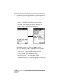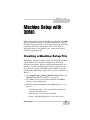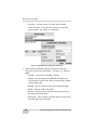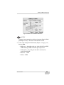
1
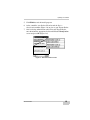
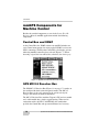
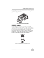
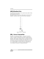
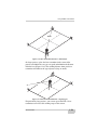
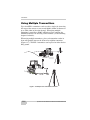
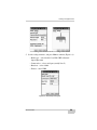
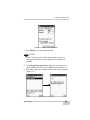
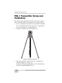
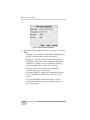
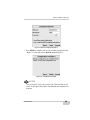
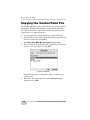
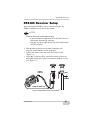
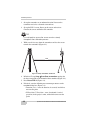
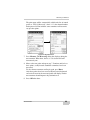
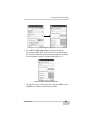
EQUIPMENT AUTOMATION: SYSTEM FIVE-3D
TM
System Five-3DTM
Reference Manual
Millimeter GPS™ Addendum
P O S I T I O N I N G
S Y S T E M S
System Five-3D
Reference Manual
Millimeter GPS Addendum
Part Number 7010-0700
Rev A
©Copyright Topcon Positioning Systems, Inc.
January, 2005
All contents in this manual are copyrighted by
Topcon Positioning System, Inc. All rights reserved.
The information contained herein may not be used, accessed, copied, stored,
displayed, sold, modified, published, or distributed, or otherwise reproduced
without express written consent from Topcon.
Terms and Conditions
Thank you for buying this Topcon product. This manual has been prepared to assist
you with the care and operation of the product and its use is subject to these Terms
and Conditions and those more fully set forth in the Operator’s/User’s Manual.
Usage and Safety
This product is designed for use by professionals. Always use safety precautions
when operating this or any Topcon product.
Copyrights
All information contained in this Manual is the intellectual property of, and
copyrighted material of TPS. All rights are reserved. You may not use, access, copy,
store, display, create derivative works of, sell, modify, publish, distribute, or allow
any third party access to, any graphics, content, information or data in this Manual
without TPS’ express written consent and may only use such information for the care
and operation of your Product. The information and data in this Manual are a valuable
asset of TPS and are developed by the expenditure of considerable work, time and
money, and are the result of original selection, coordination and arrangement by TPS.
Trademarks
HiPer, Millimeter GPS, mmGPS, Lazer Zone and Topcon are trademarks or
registered trademark of Topcon Positioning Systems, Inc. Windows and the Windows
CE icon are registered trademarks of Microsoft Corporation.
Other product and company names mentioned herein may be trademarks of their
respective owners.
Disclaimer of Warranty
EXCEPT FOR SUCH WARRANTIES AND LICENSES PROVIDED WITH THE PRODUCT,
THIS MANUAL AND THE PRODUCT ARE PROVIDED “AS-IS”. TOPCON AND ITS
DISTRIBUTORS SHALL NOT BE LIABLE FOR TECHNICAL OR EDITORIAL ERRORS OR
OMISSIONS CONTAINED HEREIN; NOR FOR INCIDENTAL OR CONSEQUENTIAL
DAMAGES RESULTING FROM THE FURNISHING, PERFORMANCE OR USE OF THIS
MATERIAL OR THE PRODUCT.
Please see the Operator’s/User’s Manual for detailed information on warranties and
the license agreement which may apply to the Product.
License Agreement
Use of any computer programs or software supplied by Topcon or downloaded from
the Topcon website in connection with the Product implies acceptance of the Terms
and Conditions here and in the Operator’s/User’s Manual.
Please see the Operator’s/User’s Manual for detailed information on warranties and
the license agreement which may apply to the Product.
ECO#2354
TOC
Table of Contents
Chapter 1
Introduction ............................................................ 1-1
Updating for mmGPS ..........................................................
Updating 3DMC ............................................................
Updating Pocket-3D ......................................................
mmGPS Components for Machine Control .........................
Control Box and 3DMC ................................................
GPS MC-2.5 Receiver Box ...........................................
PZS-MC Sensor ............................................................
GPS Vibration Pole .......................................................
PZL-1 Laser Transmitter ...............................................
PZS-1 Sensor and GPS+ Receiver ................................
Pocket-3D ......................................................................
Using mmGPS at the Jobsite ...............................................
Placing Transmitters at the Jobsite ................................
Using Multiple Transmitters .........................................
1-2
1-2
1-3
1-6
1-6
1-6
1-7
1-8
1-8
1-9
1-10
1-11
1-12
1-14
Chapter 2
Equipment Setup with Pocket-3D ......................... 2-1
Creating an Equipment File ................................................. 2-1
PZL-1 Transmitter Setup and Calibration ........................... 2-6
PZS-1 Sensor Setup and Initialization ................................. 2-10
Chapter 3
Machine Setup with 3DMC ..................................... 3-1
Creating a Machine Setup File ............................................
Copying the Control Point File ............................................
PZS-MC Receiver Setup ......................................................
PZL-1 Transmitter Setup .....................................................
P/N 7010-0700
3-1
3-6
3-7
3-9
i
Table of Contents
Chapter 4
mmGPS Operations ................................................ 4-1
Performing a Resection .......................................................
Checking the Transmitter’s Height .....................................
Transmitter Adjustment .......................................................
Viewing a Cut/Fill History ..................................................
ii
4-1
4-4
4-6
4-9
System Five-3D Reference Manual mmGPS Addendum
Chapter 1
Introduction
Topcon’s Lazer Zone™ and Millimeter GPS™ (mmGPS) products
provide unparalleled measuring accuracy at the jobsite.
• The millimeter GPS system is up to 300% more accurate than
standard GPS.
• The Lazer Zone transmitter provides wide vertical measurement
area of 600m/2000ft diameter and 10m/33ft height
• The system provides multiple rover support for machine and pole
mounted sensors.
• The technology works with existing Topcon GPS+ systems.
For System Five-3D applications, mmGPS consists of three primary
components: the PZL-1 transmitter set up over a control point, the
PZS-1 sensor on a range pole with a GPS+ receiver, and the PZS-MC
sensor installed on the machine (Figure 1-1).
Figure 1-1. System Five-3D with mmGPS
P/N 7010-0700
1-1
Introduction
Updating for mmGPS
Control Box and Pocket-3D options enable specific functions for
different applications. To update the Control Box and Pocket-3D for
mmGPS, purchase these options from your Topcon Dealer. Options
are activated after entering two authorization codes.
When contacting your Topcon Dealer for authorization codes to
enable mmGPS options, you will need the following information:
• Device identification
• Contact phone number
• Company name
• Contact email address
• Contact name
• Equipment type (System
Five-3D or Pocket-3D)
• Company address
Updating 3DMC
1. Tap Topcon LogoViewAbout 3DMC. Press Options, then
press Modify (Figure 1-2).
1
2
Figure 1-2. View 3DMC Options
1-2
System Five-3D Reference Manual mmGPS Addendum
Updating for mmGPS
2. From the ControlBox dialog box, record the Device identification
number to give to your Topcon representative (Figure 1-3 on
page 1-3). Contact your Topcon representative to purchase new
authorization codes for the desired application.
3. When you have received the new authorization codes, enter the
codes into the ControlBox dialog box using the alpha-numeric
keyboard (Figure 1-3).
Figure 1-3. Enter New Authorization Codes
4. Press Ok to apply the new codes and options. Press Ok on each
screen to return to the Main Screen.
5. Turn off the Control Box, wait a couple seconds, and then turn on
the Control Box to activate the new passwords.
Updating Pocket-3D
1. Connect your computer and hand-held controller.
Because ActiveSync will automatically install Pocket-3D once it
has been loaded onto the computer, this step can be performed at
any time.
2. Insert the 3DMC software CD into the computer CD drive of the
computer. Navigate to the CD’s files using Windows® Explorer
and open the Pocket-3D folder.
3. Click the Pocket-3D setup icon to run the install program and
click Next on the Welcome screen (Figure 1-4). Follow the onscreen instructions.
P/N 7010-0700
1-3
Introduction
Figure 1-4. Begin Pocket-3D Installation
4. After installing applicable files to the computer, ActiveSync will
start up and retrieve the controller’s programs.
• If Pocket-3D is already installed, ActiveSync will uninstall it
from the controller. When done, double-click the Pocket-3D
setup icon to install the software on the controller.
• For new installations, ActiveSync will begin the Pocket-3D
install process for the controller (Figure 1-5). Click Yes to
install Pocket-3D to the default directory on the controller.
Figure 1-5. Install Pocket-3D on Controller
1-4
System Five-3D Reference Manual mmGPS Addendum
Updating for mmGPS
5. Click Finish to exit the install program.
6. At the controller, start Pocket-3D and record the Device
identification number (Figure 1-6) to give to your Topcon Dealer.
7. After receiving authorization codes from your Topcon Dealer,
enter them into the appropriate fields on the Device Identification
screen and press Ok (Figure 1-6).
Figure 1-6. Enter Authorization Codes
P/N 7010-0700
1-5
Introduction
mmGPS Components for
Machine Control
Besides the standard components as seen in the System Five-3D
Reference Manual, mmGPS applications include the following
components.
Control Box and 3DMC
At the Control Box, the 3DMC software for mmGPS includes two
extra Control menu options for setting up the PZS-MC receiver and
PZL-1 transmitter. The Elevation Control Key also displays an icon
indicating mmGPS control has been selected (Figure 1-7). When
detecting a signal, the icon will be blue; otherwise, the icon is gray.
Figure 1-7. System Five-3D Control Box with mmGPS
GPS MC-2.5 Receiver Box
The GPS MC-2.5 Receiver Box (Figure 1-8 on page 1-7) attaches to
the machine with shock isolated magnetic mounts. The MC-2.5
Receiver Box can be easily removed at the end of each day for
storage, and contains no manual adjustment.
The MC-2.5 Receiver Box combines Topcon’s GPS receiver module
and a radio module into a single, rugged housing. When used in
conjunction with a the PZL-1 and PZS-MC, this combination
provides the Control Box and operator millimeter level accuracy.
1-6
System Five-3D Reference Manual mmGPS Addendum
mmGPS Components for Machine Control
The Control Box processes these measurements to compute grade and
graphical mapping information.
Figure 1-8. MC-2.5 Rover GPS Receiver Box
PZS-MC Sensor
The PZS-MC (Figure 1-9) replaces the machine-mounted GPS
antenna. The PZS-MC combines the MC-A1 GPS antenna with laser
sensor technology into a total package. Lazer Zone technology allows
the sensor to detect up to four different PZL-1 transmitters for
increased range. The sensor attaches to a GPS vibration pole on the
machine blade, and two cables connect the receiver to the MC-2.5
Receiver Box for sending corrections to the Control Box.
Figure 1-9. PZS-MC Machine Control mmGPS Sensor
P/N 7010-0700
1-7
Introduction
GPS Vibration Pole
The GPS Vibration Pole (Figure 1-10) installs on the machine’s blade
with several types of mounts.
The GPS Vibration Pole provides a lightweight, fixed mount for the
PZS-MC, and utilizes shock isolation and vibration dampening.
Figure 1-10. GPS Vibration Pole
PZL-1 Laser Transmitter
The PZL-1 laser transmitter (Figure 1-11 on page 1-9) operates
similar to a standard rotating laser, but transmits a unique signal to
provide a working range of 2000ft. Instead of a traditional flat plane,
the PZL-1 emits a unique beam that provides a measuring area of 33ft
in height. Up to four laser transmitters can be linked for use on large
sites, covering a distance of nearly 8000ft or elevation changes of
over 130ft. Each PZL-1 transmitter also supports multiple rovers,
even at different elevations for continuous production.
1-8
System Five-3D Reference Manual mmGPS Addendum
mmGPS Components for Machine Control
Figure 1-11. PZL-1 Laser Transmitter
PZS-1 Sensor and GPS+ Receiver
The PZS-1 sensor (Figure 1-12) instantly computes precise vertical
information from the PZL-1 laser transmitter. Using Lazer Zone™
technology, the PZS-1 automatically determines elevation based on
job site control. Mounting the PZS-1 to a range pole and attaching a
GPS+ receiver allows the sensor to receive the PZL-1 laser signal and
wirelessly transmit data to the receiver.
Figure 1-12. Receiver and PZS-1 on Rover Pole
P/N 7010-0700
1-9
Introduction
Pocket-3D
When enabled for mmGPS, Pocket-3D (Figure 1-13) has the
following added functionality:
• set up machine files for mmGPS equipment
• set up the PZL-1 transmitter over a known or unknown point
• set up the PZS-1 sensor
• check the height of the transmitter
• perform a field calibration to adjust the transmitter
• view a history of cuts and fills
To enable Pocket-3D for mmGPS, contact your local Topcon
representative to obtain the upgrade.
Figure 1-13. Pocket-3D with mmGPS on the FC-100
Refer to the Pocket-3D Reference Manual and Pocket-3D User’s
Manual for details on the software.
1-10
System Five-3D Reference Manual mmGPS Addendum
Using mmGPS at the Jobsite
Using mmGPS at the Jobsite
mmGPS uses Topcon’s unique Lazer Zone™ technology to produce
millimeter accuracy. Lazer Zone technology combines the simplicity
of a rotating laser, the accuracy of a robotic total station, and the
flexibility and multiple-user capabilities of GPS into one complete
jobsite solution (Figure 1-14).
• The PZL-1 laser transmitter emits a unique laser beam that
provides a working range up to 2000ft (600m).
• The PZS-MC laser sensor and GPS receiver at the machine
detects the laser beam and satellite signals, sending millimeter
accurate positioning data to the control box for correction control.
• The PZS-1 sensor and GPS receiver detects the laser beam and
satellite signals, providing millimeter accurate spot-checks
throughout the jobsite.
Figure 1-14. mmGPS at the Jobsite
P/N 7010-0700
1-11
Introduction
Placing Transmitters at the Jobsite
The physical location of the laser transmitter on the jobsite should be
outside the actual grading area, if possible. When choosing a location
to place the laser transmitter, remember the following two
recommendations.
1. Minimize the working distance from the laser transmitter.
As the distance from the laser transmitter increases, grade
accuracy decreases. The following factors affect grade at long
distances:
• Ground vibration from
machinery working near the
laser transmitter
• Laser movement from
blowing wind
• Atmospheric conditions
• Calibration error
2. Keep the laser transmitter as low as possible.
Keeping the laser transmitter low, where you can reach it, will
make setup and occasional adjustments easier. The transmitter
and laser receiver on the machine will also be more stable. On
windy days, you may need to anchor the tripod to keep the laser
transmitter from moving.
The laser transmitter does not need to be above the machinery on
the job. The benefits of keeping it low, as well as GPS
capabilities, far outweigh the momentary loss of the laser beam
due to passing equipment.
On small projects, place the laser transmitter off the working area
(Figure 1-15 on page 1-13). The working distance from your laser
will indicate the type of project (small or large).
1-12
System Five-3D Reference Manual mmGPS Addendum
Using mmGPS at the Jobsite
2000'
Figure 1-15. Laser Transmitter Placement – Small Project
On larger projects, place the laser transmitter in the center of the
project to maximize the area you can grade and minimize the distance
from the laser (Figure 1-16). The working distance from your laser
transmitter will indicate the type of project (large or small).
2000'
2000'
Figure 1-16. Laser Transmitter Placement – Larger Project
For particularly large projects, you can use up to four PZL-1 laser
transmitters to increase the working range of the sensors.
P/N 7010-0700
1-13
Introduction
Using Multiple Transmitters
Up to four PZL-1 transmitters can be used for a single job, increasing
the range of the sensors to cover nearly 8000ft (2438m) in distance or
up to 130ft (40m) of elevation changes. When using multiple
transmitters, you will use 3DMC and Pocket-3D to configure the
PZS-MS and PSZ-1 for detecting each transmitter (see the following
chapters for details).
When using multiple transmitters, place each transmitter so that its
beam will partially intersect the beam of its neighbor transmitter
(Figure 1-17). The PZL-1 transmitters can be placed on either level or
hilly ground.
Figure 1-17. Multiple Laser Transmitter Placement
1-14
System Five-3D Reference Manual mmGPS Addendum
Chapter 2
Equipment Setup with
Pocket-3D
When setting up the PZL-1 transmitter and PZS-1 sensor, Pocket-3D
provides the interface for building equipment files, calibrating the
transmitter, and initializing the sensor.
Creating an Equipment File
Equipment configuration files contain information on the specific
machine, laser or GPS+ receiver, prism, radio, etc. for the job
application and setup. Pocket-3D uses this information to accurately
portray jobsite information on the main screen.
Before initializing or localizing a GPS+ system, there must be an
equipment configuration file defined in Pocket-3D. The following
procedure is an example of a HiPer receiver configuration for
mmGPS applications.
NOTICE
NOTICE
Incorrect measurements or typographical errors directly
affect grading accuracy.
1. Press SetupEquipment to create or select an equipment
configuration file.
2. On the Machine files dialog box, press New to create the
equipment configuration, or press Edit to change an existing
equipment configuration (Figure 2-1 on page 2-2).
P/N 7010-0700
2-1
Equipment Setup with Pocket-3D
3. For mmGPS application, apply following equipment parameters,
and press Next (Figure 2-1):
• Configuration name – enter a name for the configuration file
• Machine type – select Range pole from the drop-down list
• Sensor – select GPS antenna from the drop-down list
• Location – select Top of pole from the drop-down list
• Units – select the type of unit measurement
Figure 2-1. Create or Edit an Equipment Configuration
4. Enter the antenna information using the same units of measure
entered in the previous step, then press Next to continue
(Figure 2-2 on page 2-3). These settings have a corresponding
Image tab to illustrate the setup.
• Antenna type – select a mmGPS antenna selection
• Antenna height – enter the antenna’s height
• Measured to point – select either Base or Rim
• Connection (Pocket-3D) – select the appropriate connection
port between the sensor and Pocket-3D controller
2-2
System Five-3D Reference Manual mmGPS Addendum
Creating an Equipment File
Figure 2-2. Antenna Information Dialog Box
5. Set the radio parameters, and press Next to continue (Figure 2-3):
• Radio type – select Pacific Crest PDL UHF or Internal
Spread Spectrum
• Connected to – select serial port (usually Port C)
• Baud rate – select 38400
• Format – select CMR
Figure 2-3. Radio Setup Dialog Box
P/N 7010-0700
2-3
Equipment Setup with Pocket-3D
6. Select the following Lazer Zone parameters (Figure 2-4 on
page 2-5):
• GPS port – select the port used for GPS communication
between receiver and sensor (typically port D).
• Sensitivity – select the sensitivity level for detecting the
transmitter, usually Auto. Select a different setting when
working at very short or very long distances, or during
inclement weather that can affect laser detection.
• Channels – select the channel to scan for mmGPS
connection. The “All” selection will allow the sensor to
independently select the transmitter with the smallest error
rate1. If setting up only one transmitter, but the job has been
configured for multiple transmitters, select the individual ID
of the transmitter for the sensor to detect.
• LaserZone aided init – select to use the mmGPS signal to
assist in initializing the GPS receiver. This option is useful to
decrease the initialization time when satellite visibility is
limited (for example, tracking only four or five satellites).
• Calc. LaserZone/GPS weighted elevations – select to
combine Lazer Zone elevations and GPS elevations. When
selected, this option will force the receiver/sensor to always
consider the angle and distance when determining the
elevation, then combine the two elevations accordingly. This
option works well at large (300m) distances and steep angles.
1. Note the following exception:
If using more than one transmitter, and all transmitters have been
previously calibrated and initialized, selecting “All” will cause the
Pocket-3D program to search for the transmitter with the smallest error
rate, even if the physical unit is not set up. In this case, the sensor will
not detect the transmitter.
2-4
System Five-3D Reference Manual mmGPS Addendum
Creating an Equipment File
Figure 2-4. Select Lazer Zone Information
7. Press Finish to save the configuration file.
NOTICE
NOTICE
Press Finish to save the file. Failure to do so results in
losing all information and will require you to repeat the
process.
8. On the Equipment configuration dialog box, select the new or
edited configuration file, and press Ok to continue (Figure 2-5).
9. Press Yes to apply the configuration file as the current equipment
(Figure 2-5).
Figure 2-5. Select Equipment Configuration
P/N 7010-0700
2-5
Equipment Setup with Pocket-3D
PZL-1 Transmitter Setup and
Calibration
For machine control applications, the PZL-1 transmitter attaches to
either a standard tripod or a fixed 2m tripod over a surveyed point.
1. Locate a control point over which to set up the PZL-1 transmitter.
Or, see “Performing a Resection” on page 4-1 to automatically
locate the transmitter over an unknown point.
2. Attach the transmitter to the tripod (Figure 2-6).
Figure 2-6. Setup PZL-1 Transmitter
3. Turn on the transmitter’s power and select a channel for the
transmitter (Figure 2-7 on page 2-7).
To assign a channel to the transmitter, press the channel button
until the corresponding LED lights up.
2-6
System Five-3D Reference Manual mmGPS Addendum
PZL-1 Transmitter Setup and Calibration
4. Connect the transmitter and Pocket-3D controller (Figure 2-7).
Check that a mmGPS-enabled machine configuration is loaded.
FC-100
Press button to select
channel for transmitter.
Connect Pocket-3D
controller and transmitter.
Figure 2-7. Select Channel and Connect Controller
5. Tap SetupLaserZone Transmitters to set up from one to four
transmitters in Pocket-3D.
6. Tap the right arrow to scroll through the tabs on the transmitter
setup dialog box. Then tap the Transmitters tab (Figure 2-8 on
page 2-8).
• To load transmitter data for the first time – tap Download
to retrieve calibration data from the connected transmitter.
The download is complete when the firmware version
displays in the Firmware column.
• To add a transmitter – tap Add and enter a transmitter serial
number or other description.
• To delete a transmitter – select a transmitter and tap Delete.
• To adjust the transmitter – see “Transmitter Adjustment”
on page 4-6.
Once the Transmitters tab contains a list of transmitters, each
transmitter must be setup on a unique channel. The channel
button on the transmitter determines the channel that the
transmitter broadcasts on.
P/N 7010-0700
2-7
Equipment Setup with Pocket-3D
Figure 2-8. Load Transmitters into Pocket-3D
7. Tap the channel tab for the connected transmitter and set the
following parameters (Figure 2-9 on page 2-9):
• From the Transmitter drop-down list, select the description of
the connected transmitter.
• Select the control point that the transmitter is set up over.
• Enter the height of the antenna:
– If using a two meter fixed tripod, select this checkbox.
– If using another tripod, enter the height of the transmitter
from the ground to the mark on the transmitter’s side.
8. If needed, repeat step 7 for up to three other transmitters.
2-8
System Five-3D Reference Manual mmGPS Addendum
PZL-1 Transmitter Setup and Calibration
9. Press OK when done.
Figure 2-9. Enter Transmitter Channel and Control Point Data
P/N 7010-0700
2-9
Equipment Setup with Pocket-3D
PZS-1 Sensor Setup and
Initialization
For machine control applications, the PZL-1 transmitter attaches to
either a standard tripod or a fixed 2m tripod over a surveyed point.
The following procedure requires a mmGPS-enabled machine
configuration file to be selected in Pocket-3D.
1. Connect the GPS+ receiver to the 5/8inch plug on the PZS-1
sensor.
2. Connect the PZS-1 to the range pole.
3. Connect the serial cable from port D of the GPS+ receiver to the
serial port on the PZS-1 sensor.
4. Turn on the power to both the receiver and sensor.
5. Connect the Pocket-3D controller and GPS+ receiver using one of
the following techniques:
• A serial cable connected to port A of the receiver.
• Bluetooth wireless technology.
Figure 2-10. Connect Receiver and Sensor
2-10
System Five-3D Reference Manual mmGPS Addendum
PZS-1 Sensor Setup and Initialization
6. In Pocket-3D, tap SetupLaserZone receiver.
7. Select the following Lazer Zone parameters (Figure 2-11):
• GPS port – select the port used for GPS communication
between receiver and sensor (typically port D).
• Sensitivity – select the sensitivity level for detecting the
transmitter, usually Auto. Select a different setting when
working at very short or very long distances, or during
inclement weather that can affect laser detection.
• Channels – select the channel to scan for mmGPS
connection. See page 2-4 for details.
• LaserZone aided init – select to use the mmGPS signal to
assist in initializing the GPS receiver. See page 2-4 for
details.
• Calc. LaserZone/GPS weighted elevations – select to
combine Lazer Zone elevations and GPS elevations. See
page 2-4 for details.
8. Tap OK.
Figure 2-11. Select Lazer Zone Information
P/N 7010-0700
2-11
Equipment Setup with Pocket-3D
Notes:
2-12
System Five-3D Reference Manual mmGPS Addendum
Chapter 3
Machine Setup with
3DMC
When setting up the machine for mmGPS, the control box and 3DMC
software provides the interface for building machine files, entering
PZS-MC receiver information, and selecting channels for one or more
transmitters. Transmitter information, such as serial number/
description, firmware and adjusted status, comes from a copied
Pocket-3D control point file.
Creating a Machine Setup File
The Machine Configuration file provides vital information about the
type of machine, the setup of the components on the machine,
machine measurements, and radio configuration information. You
must have a machine configuration file before beginning to grade.
If you need to set up the Control Box on the machine, refer to the
specific control application’s chapter in the System Five-3D Reference
Manual.
1. Press Topcon LogoControlMachine setup to display the
Machine files dialog box (Figure 3-1 on page 3-2).
2. Press New to create a new machine configuration or Edit to
change a current configuration.
3. Enter the following information and tap Next (Figure 3-1 on
page 3-2):
• Configuration name – enter a name for the configuration
using the pop-up keyboard
• Machine type – select the type of machine
• Sensor – for mmGPS application, select GPS antenna
P/N 7010-0700
3-1
Machine Setup with 3DMC
• Location – select the sensor’s location on the machine
• Units of measure – select the unit of measure used in the
project (meters, feet, inches, or centimeters)
Figure 3-1. Enter Machine Configuration Information
4. Enter antenna information using the same units of measure
selected in the previous step (Figure 3-2 on page 3-3). Then tap
Next.
• Antenna – select Topcon PZS-MC (mmGPS)
• Height – enter the height of the PZS-MC using the most
vertical distance between the corner on the rim of the antenna
and the cutting edge
• Behind – enter the distance of the sensor behind the blade
• Width – enter the width of the blade
• Beyond – only for graders, enter the distance of the sensor
beyond the end of the blade
• From right – only for dozers, enter the distance of the sensor
from the right edge of the blade
3-2
System Five-3D Reference Manual mmGPS Addendum
Creating a Machine Setup File
Figure 3-2. Enter Sensor and Blade Information
NOTICE
NOTICE
Incorrect measurements or data entry errors directly affect
grading accuracy. Take each measurement twice.
5. Select radio configuration information (Figure 3-3 on page 3-4),
then tap Next:
• Radio type – depending radio type, either Pacific Crest PDL
UHF, TeleDesign UHF, or Internal Spread Spectrum
• Connected to – the serial port the radio is connected to,
usually Serial Port B
• Baud rate – 38400
• Format – CMR
P/N 7010-0700
3-3
Machine Setup with 3DMC
Figure 3-3. Enter Radio Configuration
6. Select Lazer Zone information (Figure 3-4 on page 3-5) and tap
Next:
• GPS port – select the port used for GPS communication on
the MC-2.5 Receiver Box; usually, Serial Port C.
• Sensitivity – select the sensitivity level for detecting the
transmitter, usually Auto. Select a different setting when
working at very short or very long distances, or during
inclement weather that can affect laser detection.
• Channels – select the channel to scan for mmGPS
connection. See page 2-4 for details.
• LaserZone aided init – select to use the mmGPS signal to
assist in initializing the GPS receiver. See page 2-4 for
details.
• Calc. LaserZone/GPS weighted elevations – select to
combine Lazer Zone elevations and GPS elevations. See
page 2-4 for details.
3-4
System Five-3D Reference Manual mmGPS Addendum
Creating a Machine Setup File
Figure 3-4. Select LaserZone Information
7. Press Finish to complete and save the machine configuration file
(Figure 3-5) and return to the Machine setup dialog box.
Figure 3-5. Configuration Complete
NOTICE
NOTICE
You must press Finish to save the file. Failure to do so will
result in losing all information and require you to repeat the
process.
P/N 7010-0700
3-5
Machine Setup with 3DMC
Copying the Control Point File
For mmGPS applications, the control point file also stores transmitter
information, including calibration data, setup location, and height
data. This information is copied from a Pocket-3D controller to the
Control Box via a compact flash card.
1. Save the Pocket-3D control point file to a compact flash card.
2. Insert the CF card that contains the mmGPS control point file into
the CF card slot on the Control Box.
3. Tap Topcon LogoFileControl points and tap Copy.
4. Select “from data card to internal disk” and the file to copy from
the Project files list (Figure 3-6). Tap OK.
Figure 3-6. Copy File
During the copy process, an hourglass displays to indicate the
system is busy.
5. When done, select the copied file on the Control point files
dialog box and tap OK.
3-6
System Five-3D Reference Manual mmGPS Addendum
PZS-MC Receiver Setup
PZS-MC Receiver Setup
After mounting the PZS-MC receiver to the vibration pole, use
3DMC to configure the receiver for the machine.
NOTICE
NOTICE
Note the following setup requirements:
– Face the receiver’s logo and LEDs forward; face the
connectors towards the machine.
– Connect the right-angle end of the serial cable to the
PZS-MC receiver.
1. With the blade placed on level ground, position the pole
vertically, then mount the receiver on the pole.
2. Connect the antenna cable and serial cable to the receiver
(Figure 3-7).
3. At the MC-2.5 Receiver Box, connect the antenna cable to the
Main GPS antenna port and the serial cable to the Main C serial
port (Figure 3-7).
ToMain C
Ser
ial Por
t
LED's
FORW
ARD
ToMain GPS An
tenna Por
t
Figure 3-7. Mount Receiver and Connect Cables
P/N 7010-0700
3-7
Machine Setup with 3DMC
4. At the control box, press Topcon LogoControlPZS-MC
receiver and select the following receiver parameters. Then press
OK (Figure 3-8 on page 3-9):
• Receiver port – select the port used for GPS communication
at the MC-2.5 Receiver Box; usually Serial Port C.
• Receiver sensitivity – select the sensitivity level for detecting
the transmitter, usually Auto. Select a different setting when
working at very short or very long distances, or during
inclement weather that can affect laser detection.
• Transmitter selection – select the channel to scan for mmGPS
connection. The “Any” selection will allow the sensor to
independently select the transmitter with the smallest error
rate1. If setting up only one transmitter, but the job has been
configured for multiple transmitters, select the individual ID
of the transmitter for the sensor to detect.
• LaserZone aided init – select to use the mmGPS signal to
assist in initializing the GPS receiver. See page 2-4 for
details.
• Calc. LaserZone/GPS weighted elevations – select to
combine Lazer Zone elevations and GPS elevations. See
page 2-4 for details.
1. Note the following exception:
If using more than one transmitter, and all transmitters have been
previously calibrated and initialized, selecting “Any” will cause the
3DMC program to search for the transmitter with the smallest error rate,
even if the physical unit is not set up. In this case, the sensor will not
detect the transmitter.
3-8
System Five-3D Reference Manual mmGPS Addendum
PZL-1 Transmitter Setup
Figure 3-8. Select PZS-MC Receiver Information
PZL-1 Transmitter Setup
After loading a control point file that has mmGPS information, set up
the machine configuration for using the transmitter(s). To increase the
range of the machine, up to four transmitters can be configured.
1. Make sure the correct Control Point file is selected. The Control
Point file stores all transmitter information, including calibration
data, setup location, and height data.
NOTICE
NOTICE
Changing a Control Point file will change the transmitter
information.
2. Press Topcon LogoControlPZ-L1 transmitters, then tap
the tab that corresponds to the channel of the transmitter. See
page 2-6 for assigning a channel to the transmitter.
If using two to four transmitters on the jobsite, perform the
following step for each transmitter.
3. Select the following transmitter parameters and press OK
(Figure 3-9 on page 3-10):
• Transmitter S/N – select the serial number or description of
the transmitter used on this channel
P/N 7010-0700
3-9
Machine Setup with 3DMC
• Control point – select the control point over which the
transmitter is set up
• Height – enter the height of the transmitter
Figure 3-9. Setup Transmitter
4. To view firmware and adjustment status for the transmitters, tap
the Transmitters tab (Figure 3-10).
The Adjusted column shows whether the transmitter has been
adjusted to compensate for significant changes in ambient
temperature. This information is included in the Control Point
file.
Figure 3-10. Transmitter Details
3-10
System Five-3D Reference Manual mmGPS Addendum
Chapter 4
mmGPS Operations
In the event that a point has been lost, the resection operation can
measure an unknown point based on the measurements of three or
more surrounding points. The self-leveling mechanism may also need
to be measured and the transmitter calibrated to ensure correct grade.
NOTICE
NOTICE
The following operations require that the transmitter and
sensor have already been setup as seen in Chapter 2.
For details on setting up the transmitter or sensor, see “PZL-1
Transmitter Setup and Calibration” on page 2-6 or “PZS-1 Sensor
Setup and Initialization” on page 2-10.
Performing a Resection
The resection function measures an unknown transmitter location
using the rover and three or more points. In general, the results from a
resection are adequate for horizontal positioning of the transmitter (an
error estimate will also display). Performing a height check and
adjustment will fine-tune the calculated elevation.
When performing a resection, use the following guidelines to ensure
accurate measurements at the Rover points:
• take measurements at three or more points around the Base
transmitter in a balanced, symmetrical pattern (not clustered in
one area)
• have the sensor facing towards the transmitter during each
measurement
• angle the sensor between 6° higher or lower than the transmitter’s
beam, not straight on
P/N 7010-0700
4-1
mmGPS Operations
1. Set up the transmitter at an unknown location. Power on the
transmitter and select a channel to transmit on.
2. Set up the PZS-1 sensor. Power on the sensor and receiver.
Connect the sensor and Pocket-3D controller.
TIP
TIP
Use a bi-pole to ensure the sensor remains steady
throughout the calibration process.
3. Walk several feet away from the transmitter and face the sensor
towards the transmitter (Figure 4-1).
10 ft
Figure 4-1. Setup Transmitter and Sensor
4. In Pocket-3D, tap SetupLaserZone transmitters and tap the
tab that corresponds to the channel of the transmitter (Figure 4-2).
5. Press Resect PZL-1 (Figure 4-2).
6. If desired, enter the following measurement parameters on the
resection dialog box (Figure 4-2).
• Duration (secs) – enter the duration, in seconds, in which to
measure the point
• H. Precision / V. Precision – enter a horizontal / vertical
precision, in the project’s units, with which to measure the
point
4-2
System Five-3D Reference Manual mmGPS Addendum
Performing a Resection
The point name will be automatically added to the list of control
points as “TX-[n] (Resected)”, where “n” is the channel number.
Subsequent resections with the same transmitter will overwrite
any previous points.
Figure 4-2. Begin Resection
7. Press Measure. The Measuring dialog box displays during the
measurement. When done, the Pts. in calculation field will
increment by one.
8. Move to the next point and repeat step 7. Continue until at least
three points, evenly located around the transmitter, have been
measured.
To clear the measurements and begin again, press Reset.
After three points have been successfully measured, horizontal
and vertical errors for the measured point will display. Further
measurements should improve the positional error.
9. Press OK when done.
P/N 7010-0700
4-3
mmGPS Operations
Checking the Transmitter’s
Height
1. Set up the transmitter and tripod at an known control point. Power
on the transmitter and select a channel to transmit on.
2. Set up the PZS-1 sensor over a known point. Power on the sensor
and receiver. Connect the sensor and Pocket-3D controller.
TIP
TIP
Use a bi-pole to ensure the sensor remains steady
throughout the calibration process.
3. In Pocket-3D, tap SetupLaserZone transmitters and tap the
tab that corresponds to the channel of the transmitter (Figure 4-3
on page 4-5).
4. Press Check PZL-1 height (Figure 4-3 on page 4-5).
5. Use one of the following options to enter the location or elevation
of the point (Figure 4-3 on page 4-5):
• If the Transmitter is set up over a known control point, tap the
radio button then select the control point from the drop-down
list.
• If the Transmitter is set up over a point with a known
elevation, select the radio button then enter the elevation.
4-4
System Five-3D Reference Manual mmGPS Addendum
Checking the Transmitter’s Height
Figure 4-3. Begin Height Check
6. Press OK. The Measuring dialog box displays during the
measurement. When done, the Transmitter height field displays
the calculated difference between the height originally specified
for the transmitter and the calculated height (Figure 4-4).
Figure 4-4. Measure Height of Transmitter
7. To apply this change to the transmitter setup, press OK. Or press
Cancel to exit without saving the measurement.
P/N 7010-0700
4-5
mmGPS Operations
Transmitter Adjustment
The adjustment function fixes errors in incline in the self-leveling
mechanism of the transmitter, applying an offset to the transmitter.
1. Set up the transmitter and tripod at an known control point.
2. At the transmitter, hold the plumb beam key, then press and
release the power key to put the transmitter into calibration
mode.
3. Turn the front of the transmitter towards the sensor.
4. Set up the PZS-1 sensor at the same level as the transmitter, on
relatively level ground, and approximately 50 meters (100 feet)
away. Power on the sensor and receiver (Figure 4-5). Connect the
sensor and Pocket-3D controller.
TIP
TIP
Use a bi-pole to ensure the sensor remains steady
throughout the calibration process.
Hold Plumb Beam Key,
then turn on power
50 ft
Figure 4-5. Setup Transmitter and Sensor
5. In Pocket-3D, tap SetupLaserZone transmitters and tap the
Transmitters tab (Figure 4-6 on page 4-7).
4-6
System Five-3D Reference Manual mmGPS Addendum
Transmitter Adjustment
6. Press Adjust (Figure 4-6).
If indicated, check the setup listed on-screen (Figure 4-6).
Figure 4-6. Begin Field Calibration Adjustment
7. Press Next to begin the first phase of the adjustment (Figure 4-7).
8. If needed, adjust the height of the sensor so the angle is less than
1°. Once the angle is ok, tap Next.
Figure 4-7. Begin Adjustment
NOTICE
NOTICE
If the sensor experiences excessive movement during any
stage of the adjustment, an error message will display.
Press Cancel and stabilize the Rover pole. Then press
Adjust again.
P/N 7010-0700
4-7
mmGPS Operations
9. Follow the on-screen instructions, pressing Next to measure.
If indicated, check the setup listed on-screen.
When the adjustment completes, the Adjustment dialog box displays
the offsets (Figure 4-8).
• If both Axis measurements are less than 10'', no adjustment is
needed at the transmitter.
• If either or both Axis measurements are more than 10'', disconnect
from the sensor and connect to the transmitter. Press Finish to
upload the adjustments to the transmitter. When finished
uploading, the transmitter will apply the adjustments and turn off.
Figure 4-8. Adjustment Results
TIP
TIP
After loading the new self-leveling offset data into the
transmitter, re-calibrate to check the system. The
transmitter may need to be calibrated a couple of times
depending on site conditions.
Note that this process only applies an offset to the self-leveling
mechanism to ensure correct grade, the control point file is not
affected.
4-8
System Five-3D Reference Manual mmGPS Addendum
Viewing a Cut/Fill History
Viewing a Cut/Fill History
For mmGPS applications, both 3DMC and Pocket-3D have an option
to view the cut/history of the loaded project.
• In Pocket-3D, tap DisplayCut/fill history.
• In 3DMC, tap Topcon LogoViewLower windowCut/fill
history.
The cut/fill window (Figure 4-9) displays the on-going highs and
lows of the project as determined by both laser and GPS readings.
The red line indicates mmGPS detection; the blue line indicates GPS
only detection.
Figure 4-9. Cut/fill History Windows for 3DMC and Pocket-3D
P/N 7010-0700
4-9
mmGPS Operations
Notes:
4-10
System Five-3D Reference Manual mmGPS Addendum
Notes:
Notes
Notes:
Notes
TOPCON
Topcon Positioning Systems, Inc.
7400 National Drive
Livermore, California U.S.A.
Phone: 800 • 443 • 4567
© 2005 Topcon Corporation. All rights reserved.
No unauthorized duplication.
P/N: 7010-0700 Rev. A Printed in U.S.A. 1/05 75