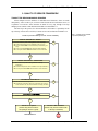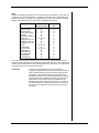
1
7UDQVLW&DSDFLW\DQG4XDOLW\RI6HUYLFH0DQXDO
PART 5
QUALITY OF SERVICE
CONTENTS
1. INTRODUCTION..................................................................................................... 5-1
Overview..................................................................................................................... 5-1
Definitions............................................................................................................... 5-1
Levels of Service..................................................................................................... 5-2
Transit Performance Measures.................................................................................... 5-2
2. QUALITY OF SERVICE FRAMEWORK ............................................................ 5-5
Transit Trip Decision-Making Process........................................................................ 5-5
Quality of Service Factors........................................................................................... 5-7
Service Coverage .................................................................................................... 5-7
Pedestrian Environment .......................................................................................... 5-7
Scheduling............................................................................................................... 5-7
Amenities ................................................................................................................ 5-8
Transit Information ................................................................................................. 5-8
Transfers ................................................................................................................. 5-8
Total Trip Time....................................................................................................... 5-9
Cost ......................................................................................................................... 5-9
Safety and Security.................................................................................................. 5-9
Passenger Loads...................................................................................................... 5-9
Appearance and Comfort ...................................................................................... 5-10
Reliability.............................................................................................................. 5-10
Customer Satisfaction Surveys.................................................................................. 5-10
Transit System Size Considerations .......................................................................... 5-11
Framework ................................................................................................................ 5-12
Availability............................................................................................................ 5-12
Quality................................................................................................................... 5-13
3. QUALITY OF SERVICE MEASURES................................................................ 5-15
Introduction............................................................................................................... 5-15
Measures of Availability ........................................................................................... 5-15
Transit Stops ......................................................................................................... 5-15
Route Segments..................................................................................................... 5-19
System................................................................................................................... 5-20
Measures of Quality .................................................................................................. 5-27
Transit Stops ......................................................................................................... 5-27
Route Segments..................................................................................................... 5-29
System................................................................................................................... 5-31
4. APPLICATIONS .................................................................................................... 5-35
Introduction............................................................................................................... 5-35
Service Assessment ................................................................................................... 5-35
Policy and Goal Setting............................................................................................. 5-37
Planning and Design.................................................................................................. 5-37
Part 5/QUALITY OF SERVICE
Page 5-i
Contents
7UDQVLW&DSDFLW\DQG4XDOLW\RI6HUYLFH0DQXDO
5. REFERENCES ........................................................................................................ 5-39
6. EXAMPLE PROBLEMS ....................................................................................... 5-41
LIST OF EXHIBITS
Exhibit 5-1 Transit Performance Measure Categories and Examples ............................. 5-3
Exhibit 5-2 Transit Trip Decision-Making Process: Transit Availability........................ 5-5
Exhibit 5-3 Transit Trip Decision-Making Process: Transit Convenience...................... 5-6
Exhibit 5-4 Quality of Service Framework.................................................................... 5-12
Exhibit 5-5 Service Frequency LOS: Urban Scheduled Transit Service ....................... 5-16
Exhibit 5-6 Service Frequency LOS: Paratransit Service.............................................. 5-17
Exhibit 5-7 Service Frequency LOS: Intercity Scheduled Transit Service.................... 5-17
Exhibit 5-8 Hours of Service LOS ................................................................................ 5-19
Exhibit 5-9 Transit System Coverage Area Example .................................................... 5-21
Exhibit 5-10 Transit-Supportive Area Example ............................................................ 5-22
Exhibit 5-11 Comparative Area and Population of Example Analysis Areas ............... 5-23
Exhibit 5-12 Service Coverage LOS ............................................................................. 5-23
Exhibit 5-13 Transit Vehicle Service Availability “Bubble” ........................................ 5-26
Exhibit 5-14 Passenger Load LOS ................................................................................ 5-28
Exhibit 5-15 Typical Transit Stop Amenities................................................................ 5-29
Exhibit 5-16 Reliability LOS: On-Time Performance................................................... 5-30
Exhibit 5-17 Reliability LOS: Headway Adherence...................................................... 5-30
Exhibit 5-18 Transit/Auto Travel Time LOS ................................................................ 5-32
Exhibit 5-19 Factors Influencing Transit Quality of Service......................................... 5-35
Part 5/QUALITY OF SERVICE
Page 5-ii
Contents
7UDQVLW&DSDFLW\DQG4XDOLW\RI6HUYLFH0DQXDO
1. INTRODUCTION
OVERVIEW
Quality of service reflects the passenger’s perception of transit performance. It
measures both the availability of transit service and its comfort and convenience. Quality
of service depends to a great extent on the operating decisions made by a transit system,
especially decisions on where transit service should be provided, how often and how long
transit service should provided, and what kind of service should be provided.
Quality of service reflects the
passenger’s perspective.
Part 5 of the Transit Capacity and Quality of Service Manual presents methods for
measuring quality of service.
Organization of Part 5.
•
Chapter 1 discusses transit performance measures in general and differentiates
passenger-based quality of service measures from other kinds of transit
performance measures.
•
Chapter 2 examines the factors that enter into a potential rider’s decision to use
transit for a particular trip and introduces a framework for categorizing quality of
service measures.
•
Chapter 3 presents level of service ranges for six quality of service measures
addressing transit availability and quality for transit stops, route segments, and
systems.
•
Chapter 4 discusses applications for the quality of service measures.
•
Chapter 5 contains references for material presented in Part 5 which may be
consulted for further information regarding transit quality of service.
•
Chapter 6 presents example problems that apply quality of service measures to
“real world” situations.
Definitions
In the North American transit industry, many definitions are not standardized or are
specific to a particular transit system. Caution is needed with the terms quality of service
and level of service, which carry a variety of meanings. Level of service, for example, is
often used literally to mean the amount of service both in frequency and hours of
coverage—the latter sometimes referred to as the “span” of service.
This manual uses the following definitions of transit performance measures, quality
of service, service measures, and levels of service:
•
Transit Performance Measure. A quantitative or qualitative factor used to
evaluate a particular aspect of transit service.
•
Quality of Service. The overall measured or perceived performance of transit
service from the passenger’s point of view.
•
Transit Service Measure. A quantitative performance measure that best describes
a particular aspect of transit service and represents the passenger’s point of view.
It is also known elsewhere as a measure of effectiveness.
•
Levels of Service. Six designated ranges of values for a particular service
measure, graded from “A” (best) to “F” (worst) based on a transit passenger’s
perception of a particular aspect of transit service.
Part 5/QUALITY OF SERVICE
Page 5-1
Chapter 1—Introduction
7UDQVLW&DSDFLW\DQG4XDOLW\RI6HUYLFH0DQXDO
The primary differences between performance measures and service measures are the
following:
Indexes.
1.
Service measures must represent the passenger’s point of view, while
performance measures can reflect any number of points of view.
2.
In order to be useful to users, service measures should be relatively easy to
measure and interpret. It is recognized, however, that system-wide measures will
of necessity be more complex than bus stop or route segment measures.
3.
Level of service (LOS) grades are developed only for service measures.
However, transit operators are free to develop LOS grades for other performance
measures, if those measures would be more appropriate for particular
applications.
Indexes are a special form of performance measure that are developed by weighting
two or more other performance measures. LOS grades may or may not be assigned to
ranges of index values, depending on the application. Because the weighting systems used
depend on local data and/or policy decisions, indexes are difficult to apply on a national
basis and so are not used in this manual to develop service measures. However, indexes
are discussed in Chapter 3 for the benefit of transit operators and planners who desire to
develop measures with more detail than the basic quality of service measures presented in
this manual.
Levels of Service
The selection of level of service thresholds for each of the service measures
presented in this manual represent the collective professional judgment of the TCRP A-15
project team and panel. However, the LOS grades—in particular, LOS F—are not
intended to set national standards. It is left to local transit operators and policy agencies to
decide how to apply the LOS measures. To aid in this effort, this manual provides
guidance on the changes in service quality perceived by passengers at each LOS
threshold.
TRANSIT PERFORMANCE MEASURES
To get a sense of what quality of service is, it is useful to understand what it is not.
Exhibit 5-1 illustrates one possible way that transit performance measures can be
categorized and shows how quality of service fits into the spectrum of transit performance
measures. TCRP Synthesis 10, “Bus Route Evaluation Standards”(R2) is a useful
compilation of a number of performance measures at both the transit route and system
levels.
Operator point of view.
The operator point of view encompasses the measures routinely collected in the U.S.
for the FTA’s National Transit Database (formerly Section 15) annual reporting process.
Most of these measures relate to economy or productivity. These measures are important
to the operator—and indirectly to passengers—by reflecting the amount of service an
operator can afford to provide on a route or the system as a whole. The productivity
measures (e.g., ridership) indirectly measure passenger satisfaction with the quality of
service provided. However, only two of these reported operator measures directly relate
to the passenger’s point of view: (1) actual vehicle revenue hours per directional mile and
(2) vehicles operated in maximum service per directional mile. These measure the
“amount” of service. The first is an overall system average, while the second is an average
of the amount of service provided in the peak period (i.e., when maximum service is
deployed).
Part 5/QUALITY OF SERVICE
Page 5-2
Chapter 1—Introduction
7UDQVLW&DSDFLW\DQG4XDOLW\RI6HUYLFH0DQXDO
Exhibit 5-1
Transit Performance Measure Categories and Examples
TRAN S IT PERFORM AN C E M EAS URES
Transit performance measures can
represent the operator, passenger,
or vehicle point of view.
SERVICE OFFERED/UTILIZATION
• Annual ridership
OPERATOR
POIN T OF VIEW
• Vehicles operated in maximum
service
ECONOMICS
• Passenger trips/revenue mile
• Passenger miles/revenue hour
• Vehicle operating
expenses/revenue mile
AVAILABLITY
• Service coverage
• Hours of service
PAS S EN GER
POIN T OF VIEW
• Sidewalk condition
Quality of service reflects the
passenger point of view. Levels of
service are developed for some of
these important passenger
performance measures.
• Park & Ride spacing
“QUALITY OF S ERVIC E”
CONVENIENCE
• Passenger loading
• Transit/auto travel time
• Amenities
• Safety
VEHICULAR CAPACITY
• Bus berth capacity
• Bus lane capacity
VEHIC LE
POIN T OF VIEW
• Rail line capacity
SPEED/DELAY
• Average travel speed
• Average intersection delay per
vehicle
Performance Measures: Values without interpretation
Service Measures: Values grouped into LEVELS
OF SERVICE, grading service
quality from passengers’
perspective
Part 5/QUALITY OF SERVICE
15 hr
28 trains/hr
21.2 km/hr
shelter provided
19-24 hr 17-18 hr 14-16 hr 12-13 hr 4-11 hr
A
B
C
D
E
Page 5-3
0-3 hr
F
Performance measures provide
values without interpretation;
service measures group values
into levels of service based on the
passenger’s perspective. Service
measures are a subset of
performance measures.
Chapter 1—Introduction
7UDQVLW&DSDFLW\DQG4XDOLW\RI6HUYLFH0DQXDO
Vehicle point of view.
Passenger point of view.
The vehicle point of view includes measures of vehicular speed and delay routinely
calculated for streets and highways using the procedures given in the Highway Capacity
Manual. This point of view also includes measures of facility capacity in terms of the
number of transit vehicles that can be accommodated. Because transit vehicles carry
passengers, these measures also reflect the passenger’s point of view: passengers onboard a transit vehicle traveling at an average speed of 20 km/h (12 mph) individually
also experience this same average travel speed. However, because these vehicle-oriented
measures do not take passenger loading into account, the passenger point of view is
hidden because all vehicles are treated equally, regardless of the number of passengers in
each vehicle. For example, while a single-occupant vehicle and a 50-passenger bus
traveling on the same street may experience the same amount of delay due to on-street
congestion and traffic signal delays, the person-delay experienced by the bus is 50 times
as great as the single-occupant vehicle.
The passenger point of view, or quality of service, directly measures passengers’
perception of the availability, comfort, and convenience of transit service. As Exhibit 5-1
indicates, there are a number of possible performance measures that can be used. The
measures that have been determined to best represent the passengers’ perspective of
transit availability, comfort, and convenience, yet are relatively easy to measure, have
been selected as service measures, as shown by the darker tint. Level of service ranges
developed for these and other service measures are presented in Chapter 3.
Part 5/QUALITY OF SERVICE
Page 5-4
Chapter 1—Introduction
7UDQVLW&DSDFLW\DQG4XDOLW\RI6HUYLFH0DQXDO
2. QUALITY OF SERVICE FRAMEWORK
TRANSIT TRIP DECISION-MAKING PROCESS
Urban transport involves millions of individual travel decisions. Some are made
infrequently—where to take a job, to locate a home outside an area with transit service, or
to purchase a second car. Some decisions are made for every trip, through a two-step
thought process similar to that illustrated in Exhibit 5-2 and Exhibit 5-3.
The first step in the process is to decide whether or not transit is a possibility for the
trip. This step assesses the availability of transit service and is illustrated in Exhibit 5-2.
Exhibit 5-2
Transit Trip Decision-Making Process: Transit Availability
Step 1: Is transit service available
to a potential passenger?
SPATIAL AVAILABILITY - ORIGIN
Is there a transit stop within walking distance of the trip origin?
NO
OR Is demand-responsive service available at the trip origin?
OR Is a car available AND a Park & Ride facility located along the
way?
OR Is a bicycle available AND bike storage facilities available?
OR Is a bicycle available AND bikes allowed on transit vehicles?
YES
SPATIAL AVAILABILITY - DESTINATION
Is there a transit stop within walking distance of the trip
destination?
OR Is demand-responsive service available to the trip destination?
NO
OR Is a bicycle available AND bikes allowed on transit vehicles?
YES
INFORMATION AVAILABILITY
NO
Are the schedule and routing known?
OR Is telephone information offered, the information line not busy
when customers call, and the information accurately provided?
YES
NO
Is service available at or near the time required?
YES
Transit is an Option
Transit is Not Available
(Traveler may choose transit if
the quality of service is good)
(Traveler may choose another mode
or the trip is not taken)
See Exhibit 5-3
Part 5/QUALITY OF SERVICE
STOP
Page 5-5
Chapter 2—Quality of Service Framework
7UDQVLW&DSDFLW\DQG4XDOLW\RI6HUYLFH0DQXDO
As Exhibit 5-2 indicates, there are a number of factors that enter into determining
whether or not transit service is available. If any one of these factors is not met, transit is
not a viable mode for the trip and the traveler will either use another mode or will not
make the trip. If however, transit service is available at the trip origin and destination (or
the traveler can use another mode to get to and from transit); if information is available on
where, when, and how service is provided; and if transit service is provided at or near the
time the trip needs to be made, then transit becomes an option. Assuming the latter is
true, the decision-making process moves to step two, weighing the comfort and
convenience of transit service against competing modes. This process is illustrated in
Exhibit 5-3.
Exhibit 5-3
Transit Trip Decision-Making Process: Transit Convenience
Step 2: If transit service is
available, will a potential
passenger find it convenient?
1
3
2
4
5
1.
2.
3.
4.
5.
v
v
v
How long is the walk? Are there sidewalks and pedestrian signals?
Is the service reliable?
How long is the wait? Is there a shelter at the stop?
Are there security concerns—walking, waiting, or riding?
How crowded is the vehicle? Are the vehicles and shelters clean?
How much will the trip cost?
How many transfers are required?
How long will the trip take in total? How long relative to other modes?
Unlike the first decision, the kinds of questions weighed by a potential customer are
not necessarily all-or-nothing. Each person has their own personal values that they apply
to a given factor, and each person will “weigh” the factors shown above differently.
Regular transit users familiar with the service may perceive transit service more favorably
than non-users. In the end, the choice to use transit will depend on the availability of other
modes and how the quality of transit service compares with those competing modes.
These factors relating to transit availability, comfort, and convenience are discussed
in more detail in the next section.
Part 5/QUALITY OF SERVICE
Page 5-6
Chapter 2—Quality of Service Framework
7UDQVLW&DSDFLW\DQG4XDOLW\RI6HUYLFH0DQXDO
QUALITY OF SERVICE FACTORS
Service Coverage
Whether or not transit service is provided near one’s origin and destination is a key
factor in the choice to use transit. Ideally, transit service is provided within a reasonable
walking distance of one’s origin and destination, or demand-responsive service is
available to one’s doorstep. The specifics of “reasonable walk” varies from source to
source and depends on the situation: for example, people will walk farther to rail stations
than to bus routes and the elderly do not walk as far as “average” adults. Potential
barriers, such as wide or busy streets, hills, or an absence of pedestrian facilities, also play
an important role. In general, 0.4 km (0.25 mi) or 5 minutes walk time is the limit of a bus
route’s typical “service area”; for a rail transit station, these figures can be doubled.(R12)
If transit service is located too far
away from a potential passenger,
transit use is not an option.
If transit service is not provided near one’s origin, other possible options include
driving to a park-and-ride lot or riding a bicycle to transit. Both of these options require
that the transit operator provide additional facilities (parking lots, bicycle storage
facilities, and/or bicycle racks).
Driving or biking to transit may be
an option if transit service is
beyond walking distance.
If transit service is not provided near one’s destination, the choices are even more
limited. The car one drove to a park-and-ride lot will not be available at the destination,
nor will a bicycle left behind in a storage facility be available. A bicycle carried in a
bicycle rack on a bus will be available at the destination, but a customer will need some
degree of confidence that space will be available in the bike rack when the bus arrives. A
small number of transit systems allow bicycles on-board transit vehicles (typically rail
vehicles), but often not during peak commute hours or in the peak commute direction. A
bicycle storage facility will also be required at one’s destination and, probably (depending
on the climate and the length of the ride), showers, lockers, and changing facilities.
Service coverage must consider
both ends of a trip.
Pedestrian Environment
Even if a transit stop is located within a reasonable walking distance of one’s origin
and destination, the walking environment may not be supportive of transit. Lack of
sidewalks, poorly maintained sidewalks, lack of street lighting, and hills all discourage
pedestrian travel. Wide or busy streets without signalized crosswalks at regular intervals,
or without pedestrian refuges in the median, also discourage pedestrian travel. This latter
factor in particular poses difficulties for transit operators providing service on arterial
streets: the arterial street generally provides better transit vehicle speeds, but potential
passengers using stops along the street must cross the street at some point during their
round trip, either when they depart or when they return.
Even if transit service is
theoretically located within walking
distance of one’s origin and
destination, the areas around the
transit stops must provide a
comfortable walking environment in
order for transit to be available.
Passengers with disabilities must have sidewalk facilities, curb cuts, and bus stop
loading areas between both their origin and a transit stop and between their destination
and a transit stop in order to have the ability to access fixed-route transit service. In the
U.S., new or improved facilities must meet Americans with Disabilities Act (ADA)
standards. Without these facilities, passengers with disabilities must rely on paratransit
service, which generally provides customers with fewer choices in travel times, and
usually costs substantially more for transit operators to provide service.
Scheduling
How often transit service is provided and when it is provided are important factors in
one’s decision to use transit. The more frequent the service, the shorter the wait time
when a bus or train is missed or when the exact schedule is not known, and the greater the
flexibility customers have in selecting travel times. The number of hours during the day
when service is provided is also highly important: it does not matter whether a transit stop
is located within walking distance if service is not provided at the times one desires to
travel—transit will not be an option for that trip.
Part 5/QUALITY OF SERVICE
Page 5-7
Transit service must be available
near the time a trip needs to be
made in order for transit to be an
option for that trip.
Chapter 2—Quality of Service Framework
7UDQVLW&DSDFLW\DQG4XDOLW\RI6HUYLFH0DQXDO
Amenities
Transit stop amenities make
transit service more
comfortable and convenient for
passengers.
The kinds of amenities
provided are generally related
to the number of boarding
passengers at a stop.
The facilities that are provided at transit stops and stations help make transit more
comfortable and convenient to customers. Typical amenities, some of which were
illustrated in Exhibit 4-3, include the following:(R8)
•
Benches, to allow passengers to sit while waiting for a transit vehicle.
•
Shelters, to provide protection from wind, rain, and snow in northern climates
and from the sun in southern climates. In cold climates, some operators provide
pushbutton-operated overhead heaters at shelters located at major transit centers.
•
Informational signing, identifying the routes using the stop, their destinations
(both intermediate and ultimate), and/or scheduled arrival times.
•
Trash receptacles, to reduce the amount of litter around the transit stop.
•
Telephones, to allow passengers to make personal calls while waiting for a
transit vehicle, as well as providing for the ability to make emergency calls.
•
Vending facilities, ranging from newspaper racks at commuter bus stops to
manned newsstands, flower stands, food carts, transit ticket and pass sales, and
similar facilities at rail stations and bus transfer centers.
•
Air conditioning on-board transit vehicles, to provide a comfortable ride on hot
and humid days.
Transit operators usually link the kinds of amenities at a stop to the number of daily
boarding riders at that stop. TCRP Report 19(R8) provides guidelines for installing various
kinds of transit amenities.
Transit Information
Riders need to know where
and when transit service is
available and how to use it.
Potential riders need to know where and when transit service is available before they
can begin using it. Regular riders need to be informed about service changes that will
affect them. This information can be provided by a variety of means:
•
Printed maps, schedules, and brochures that passengers can take with them,
available on-board transit vehicles, at transit facilities, and at local businesses.
•
Posted information on-board vehicles and at transit facilities. As transit systems
adopt automatic vehicle location (AVL) systems, it is becoming feasible to
display real-time schedule information on-board buses, at bus stops, and at bus
terminals
•
On-board announcements of major transit stops assist not only the visually
impaired, but passengers unfamiliar with a route or area.
•
Telephone information available at times that are convenient to potential
passengers (including weekends and evenings).
•
Personal computers can be used to access transit information via the Internet,
and to subscribe to e-mail lists that automatically send service change and other
announcements to persons on the list.
Transfers
Requiring transfers can make
service more efficient for
operators, but is less
convenient for passengers.
Part 5/QUALITY OF SERVICE
Requiring transfers between routes adds to a passenger’s total trip time by transit,
although this can be minimized by implementing timed transfers. It also raises the
possibility that a missed connection will occur, which would further increase the length of
the transit trip. Transfers increase the complexity of a transit trip to a first-time passenger,
as well. Requiring a surcharge for transfers can inhibit ridership.
Page 5-8
Chapter 2—Quality of Service Framework
7UDQVLW&DSDFLW\DQG4XDOLW\RI6HUYLFH0DQXDO
Total Trip Time
Total trip time includes the travel time from one’s origin to a transit stop, waiting
time for a transit vehicle, travel time on-board a vehicle, travel time from transit to one’s
destination, and any time required for transfers between routes during the trip. The
importance of each of these factors varies from person to person. Some persons will view
the trip as an opportunity for exercise during the walk to transit and for catching up on
reading or work while on transit. Other persons will compare the overall door-to-door
travel time of a trip by transit to the time for the same trip by private automobile. Waiting
time at a transit stop may seem longer than the equivalent amount of time spent walking
or on-board a vehicle. In general, both the absolute travel time and the travel time in
relation to competing modes will be factors in a potential passenger’s choice to use
transit.
A longer trip by transit than by
automobile may be seen by
passengers as being less
convenient; this may be mitigated
somewhat if the on-board transit
time can be used productively
where the in-car time would not be.
Total trip time is influenced by a number of factors, including the route spacing
(affecting the distance required to walk to transit), the service frequency (affecting wait
time), and the frequency of stops, traffic congestion, signal timing, and the fare-collection
system used (affecting travel time on-board a transit vehicle).
Cost
Potential passengers weigh the cost and value of using transit versus the out-ofpocket costs and value of using other modes. Out-of-pocket transit costs consist of the
cost of the fare for each trip, or the cost of a monthly pass, while out-of-pocket
automobile costs include road and bridge tolls and parking charges. Other automobile
costs, such as fuel, maintenance, insurance, taxes, and the cost of buying an automobile
generally do not occur for individual trips and thus generally do not enter into a person’s
consideration for a particular trip. Thus, if a person does not pay a toll to drive someplace
and free parking is provided at the destination, transit will be at a disadvantage because
there will be no immediate out-of-pocket cost for driving, while there will be for transit.
Some Transportation Demand Management (TDM) techniques seek to overcome this
obstacle by encouraging employers who provide free parking (in effect subsidizing the
true cost of providing parking) to also provide subsidized transit passes or other means of
encouraging transit use as an alternative to the private automobile.
Free parking at a worksite is a
disincentive to transit use.
Safety and Security
Riders’ perceptions of the safety and security of transit, as well as actual conditions,
enter into the mode choice decision. Not only is personal safety considered, relating to
potential transit crime and vehicular crashes, but personal irritants are considered as well,
such as encountering unruly passengers on a regular basis or having to listen to someone
else’s radio. Security at transit stops can be improved by placing stops in well-lit areas
and by having public telephones available for emergency calls. Transit systems use a
variety of methods to enhance security on-board transit vehicles, including having
uniformed and plainclothes police officers ride transit, establishing community volunteer
programs, providing two-way radios and silent alarms for emergency communication, and
using video cameras.
Passengers’ perceptions of safety
must be considered in addition to
actual conditions.
Passenger Loads
Transit is less attractive when passengers must stand for long periods of time,
especially when transit vehicles are highly crowded. When passengers must stand, it
becomes difficult for them to use their travel time productively, which eliminates a
potential advantage of transit over the private automobile. Crowded vehicles also slow
down transit operation, as it takes more time for passengers to get on and off. Most transit
agencies assess the degree of passenger crowding on a transit vehicle based on the
occupancy of the vehicle relative to the number of seats, expressed as a load factor. A
factor of 1.0 means that all of the seats are occupied. The importance of vehicle loading
Part 5/QUALITY OF SERVICE
Page 5-9
The ability to find a seat on a
transit vehicle is an important
passenger comfort factor for longer
trips.
Chapter 2—Quality of Service Framework
7UDQVLW&DSDFLW\DQG4XDOLW\RI6HUYLFH0DQXDO
varies by the type of service. In general, transit provides load factors at or below 1.0 for
long-distance commute trips and high-speed mixed-traffic operations. Inner-city service
may approach 2.0 or even more, while other services will be in between. Because the
number of seats provided varies greatly between otherwise identical rail vehicles operated
by different transit systems, passengers per unit vehicle length is being applied more
often for rail capacity calculations than load factors.
Appearance and Comfort
Having clean, graffiti-free transit stops, stations, and vehicles improves transit’s
image, even among non-riders. Some transit systems (for example, Bay Area Rapid
Transit in the San Francisco Bay Area, Housatonic Area Regional Transit in Danbury,
CT, and the Tidewater Transportation Commission in Norfolk) have established standards
for transit facility appearance and cleanliness and have also established inspection
programs.(R5,R19) Passengers are also interested in ride comfort, which includes both seat
comfort and the severity and amount of acceleration and deceleration (both lateral and
longitudinal).
Reliability
Reliability includes both ontime performance and the
evenness of headways
between transit vehicles.
Reliability affects the amount of time passengers must wait at a transit stop for a
transit vehicle to arrive, as well as the consistency of a passenger’s arrival time at a
destination from day to day. Reliability encompasses both on-time performance, as well
as the regularity of headways between successive transit vehicles. Uneven headways
result in uneven passenger loadings, with a late transit vehicle picking up not only its
regular passengers but those passengers that have arrived early for the following vehicle,
with the result that the vehicle falls farther and farther behind schedule and more
passengers must stand. In contrast, the vehicles following will have lighter-than-normal
passenger loads and will tend to run ahead of schedule. With buses, this “bunching”
phenomenon is irritating both to passengers of the bunched buses, as well as to passengers
waiting for other buses, who see several buses for another route pass by while they wait
for their own bus. With signaled rail operations, bunched trains often have to wait at track
signals until the train ahead of them moves a safe distance forward. The resulting
unscheduled waits are not popular with passengers, particularly when no on-board
announcements are given explaining the delay.
Reliability is influenced by traffic conditions (for on-street, mixed-traffic operations),
vehicle maintenance and staff availability (reflecting whether a vehicle can leave the
garage or is likely to break down on the road), and by how well vehicle operators adhere
to schedules.
CUSTOMER SATISFACTION SURVEYS
Customer surveys help transit
operators identify the quality of
service factors of greatest
importance to their customers.
Passenger surveys can help transit systems identify areas where improvements are
needed to enhance customer satisfaction with transit service. These surveys can identify
not only areas of existing passenger dissatisfaction, but areas where passengers would be
strongly dissatisfied if areas that are currently performing well were to decline in
performance in the future. Thus, these surveys can help identify the quality of service
factors of greatest importance to transit riders.
The TCRP B-11 project, “Customer-Defined Transit Service Quality”(R10) was a
study that defined the elements of a transit operation that are the most important to
customers. Although the study’s intent was to develop an easy-to-use system for transit
operators to identify the most important customer-service issues affecting their system,
the pilot tests the project performed help identify some of the factors important to transit
riders, regardless of the system.
The TCRP B-11 project selected an urban rail system, a suburban bus system, and a
small city bus system for its pilot tests, and distributed more than 13,000 surveys, with
Part 5/QUALITY OF SERVICE
Page 5-10
Chapter 2—Quality of Service Framework
7UDQVLW&DSDFLW\DQG4XDOLW\RI6HUYLFH0DQXDO
response rates ranging from 33.6% to 46.3%. The project also conducted a sampling of
follow-up phone surveys. The surveys asked riders to rate 46 transit system attributes on a
scale of 1-10 and to identify whether they had experienced a problem with that attribute
within the last 30 days.
For ease of comparison, the 46 surveyed attributes can be grouped into the following
nine categories: comfort, nuisances, scheduling, fares, cleanliness, in-person information,
passive information, safety, and transfers. When analyzing the top 10 attributes that were
existing problems, scheduling was the top area of concern, followed by comfort and
nuisances. However, when potential problems were analyzed, fares and scheduling were
the top concern, followed by comfort and safety, with nuisances the category with the
least potential for high levels of concern.
The Florida Department of Transportation (FDOT) commissioned a survey of
customer satisfaction factors for six larger Florida transit systems.(R3) As with the TCRP
B-11 survey, the FDOT survey sought to identify both existing problems and potential
problems. A total of over 14,500 surveys were returned from the six systems, representing
response rates of up to 28%. The surveys covered 22 factors, including hours of service,
frequency of service, convenience of routes, on-time performance, travel time,
transferring, cost, information availability, vehicle cleanliness, ride comfort, employee
courtesy, perception of safety, bus stop locations, and overall satisfaction.
Existing problems of greatest significance to customers in Florida were hours of
service, routes, and headways. Potential problems of greatest significance were routes and
headways, service span, bus ride comfort, printed schedules, and safety and cleanliness.
TRANSIT SYSTEM SIZE CONSIDERATIONS
In measuring transit quality of service, the size of the city, metropolitan area,
“commutershed,” or transit service area may need to be taken into account. A small city
could regard transit service on a route every 30 minutes for 12 hours per day, six days per
week to be good. In a large transit system, good service could require service at least
every 10-15 minutes, 18 hours a day, seven days a week. However, these determinations
of “good service” are based as much on passenger demand and the realities of transit
operating costs as they are on passengers’ perceptions of service quality.
The question naturally arises, should there be different levels of service for different
size areas? From purely a passenger’s perspective, which quality of service is based upon,
the answer is “no”: a one-hour headway between buses is just as long for a passenger in a
small town as it is for a passenger in a large city. Therefore, no distinction has been made
in the levels of service presented in Chapter 3 to account for area population. (The
consequences of providing a one-hour headway, though, do vary by city size and are
reflected by other measures, such as passenger loads. These consequences will be more
severe in a large city than in a small city.)
From an operator’s standpoint, however, there are significant differences between
small towns and large cities, particularly in passenger demand volumes and available
funding levels. These differences can be accounted for in the way transit agencies apply
the levels of service: a small city agency may set a service frequency goal of LOS E,
while a large city agency may set a service frequency target of LOS C. The measure used
to determine level of service is the same in both cities; the difference is that one agency
sets a higher standard than the other in order to meet its service area’s greater needs.
Part 5/QUALITY OF SERVICE
Page 5-11
Level of service ranges are not
adjusted to reflect differences in
city sizes, but different operators
may wish to set different LOS
targets.
Chapter 2—Quality of Service Framework
7UDQVLW&DSDFLW\DQG4XDOLW\RI6HUYLFH0DQXDO
FRAMEWORK
Chapter 3 divides quality of service measures into two main categories: availability
and quality. The availability measures address the spatial and temporal availability of
transit service. If transit is located too far away from a potential user or if it does not run
at the times a user requires the service, that user would not consider transit service to be
available and thus the quality of service would be poor. Assuming, however, that transit
service is available, the quality measures can be used to evaluate a user’s perception of
the comfort and convenience of his or her transit experience.
Different elements of a transit system require different performance measures. The
following categories are used in Chapter 3:
•
Transit Stops. Measures addressing transit availability and convenience at a
single location. Since these measures depend on passenger volumes, scheduling,
routing, and stop and station design, performance measures in this category will
vary from one location to another.
•
Route Segments. Measures that address availability and convenience along a
portion of a route, which can range from two stops to the entire length of a route.
These measures will tend to stay the same over the length of a route segment,
regardless of conditions at an individual stop.
•
Systems. Measures of availability and convenience for more than one route
operating within a specified area (e.g., a district, city, or metropolitan area) or of
a specified type (e.g., fixed-route vs. demand-responsive). System measures can
also address door-to-door travel.
Combining the two performance measure categories with the three transit system
elements produces the matrix shown in Exhibit 5-4. Service measures presented in
Chapter 3 are shown in capital letters, while other performance measures discussed in
Chapter 3 are shown in lower case.
Exhibit 5-4
Quality of Service Framework
Performance measures in
CAPITAL LETTERS have
corresponding levels of service
in Chapter 3. Other measures
shown are discussed in
Chapter 3, but do not have
levels of service associated
with them.
Service & Performance Measures
Route Segment
System
Category Transit Stop
Availability FREQUENCY
Quality
accessibility
passenger loads
PASSENGER LOADS
amenities
reliability
HOURS OF SERVICE
accessibility
RELIABILITY
travel speed
transit/auto travel time
SERVICE COVERAGE
% person-minutes served
indexes
TRANSIT/AUTO TRAVEL TIME
travel time
safety
Some measures appear in more than one cell of the table, but only one service
measure is assigned to each cell, representing the performance measure that best
represents the passenger’s point of view of availability or convenience for a particular
transit element. In many cases, though, it may be helpful to combine the service measures
into a kind of transit “report card” that compares several different aspects of transit
service at once. An example problem in Chapter 6 illustrates this concept.
Availability
Transit Stops
The spatial aspect of transit availability at a transit stop is a given, since the stop
exists. During a typical hour-long analysis period, hours of service is also a given—either
transit service exists or it does not. Therefore, frequency is identified as the service
measure for this category.
Part 5/QUALITY OF SERVICE
Page 5-12
Chapter 2—Quality of Service Framework
7UDQVLW&DSDFLW\DQG4XDOLW\RI6HUYLFH0DQXDO
Although not so easy to quantify, transit stop accessibility by foot, bicycle, or
automobile is also an important measure of transit availability, and persons with
disabilities require special consideration. Passenger loads determine whether there is
room on a transit vehicle for additional passengers to board, which is yet another aspect
of transit availability.
Route Segments
Of the three primary measures of transit availability—frequency, hours of service,
and service coverage—frequency has already been used for transit stops, while service
coverage is a given, since the route exists. Therefore, hours of service is identified as the
service measure. This selection is an appropriate one, since more than one route, each
operating with different frequencies and travel times, can serve the same origins and
destinations. In these cases, the total span of time during which a given pair of origins and
destinations can be accessed is of greatest interest.
As with transit stops, accessibility to transit routes by foot, bicycle, automobile, and
wheelchair is important. Because pedestrian and bicycle access can vary significantly
from one stop to the next along a route, access by these modes is better addressed on a
stop-by-stop basis. In contrast, in the same amount of time it takes to walk or bike to a
stop, motorists can choose among several stops to park and get onto transit. As long as
one of these stops meets a motorist’s needs, that person has access to transit. The vehicle
equipment used along a route helps determine whether or not fixed-route transit service is
available to persons with disabilities. All new U.S. transit buses must meet ADA
requirements, but older buses in a fleet might not.
System
System availability measures look at how many people have access to transit and how
often. Service coverage within the “transit-supportive area”—the portion of an analysis
area with a population and/or job density sufficiently high to support at least hourly bus
service (equivalent to service frequency LOS E)—is identified as the service measure.
Service coverage determines how many people within the transit service area have any
access to transit. Once the areas that have service have been identified, frequency and
hours of service can be used to determine the amount of service within smaller areas.
The combination of frequency, hours of service, and service coverage together
provide a reasonable “planning level” assessment of the availability of transit service,
requiring a minimum of data collection and analysis. However, if a more detailed
“operations level” assessment is desired, there are other, more data-intensive,
performance measures to choose from, including calculating percent person-minutes
served in an area and developing indexes of transit availability.
Quality
Transit Stops
Whether or not one can find a seat on a transit vehicle is an important measure of
transit quality. Passenger loads, the selected service measure, also influences boarding
and alighting times, which in turn affect total dwell time and the capacity of transit routes.
The kinds of amenities provided at transit stops is another aspect of transit quality, but is
not a service measure because it is so highly dependent on the daily boarding passenger
volumes at a given stop: achieving better levels of service would require installing
facilities that might not be justified economically. Reliability is a third measure of quality
at a transit stop, but this measure also applies to a transit route and will tend to have
consistent values for a series of stops along a route segment.
Part 5/QUALITY OF SERVICE
Page 5-13
Chapter 2—Quality of Service Framework
7UDQVLW&DSDFLW\DQG4XDOLW\RI6HUYLFH0DQXDO
Route Segments
Reliability is identified as the service measure because it not only measures an aspect
of service quality important to users—whether or not they get to their destination on
time—but because it also affects other service measures. If transit vehicles arrive in a
bunch, or not at all, the effective service frequency is reduced. Late vehicles also have
higher passenger loads, as they pick up not only their regular passengers, but those
passengers who have arrived early for the following vehicle.
Other measures of transit quality on a route segment are the transit/auto travel time
difference (identified as the system service measure) and travel speed, both of which
relate to the time it takes to make a trip by transit. Travel speed is also important to transit
operators: if bus speeds, for example, can be increased sufficiently along a higherfrequency route that a time savings of one headway results, the number of buses required
to operate the route can decrease, along with operating costs.
System
The transit/auto travel time difference—the absolute difference in travel time from
one’s origin to one’s destination by automobile and by transit—is an important factor in a
passenger’s decision to use transit. On a system-wide basis, this measure can be
calculated by sampling a selection of locations and trip purposes within the analysis area,
or by using a transportation planning model that can calculate trip times for all
combinations of origins and destinations by transit and by automobile, for a variety of trip
purposes.
An alternative performance measure is travel time, which is useful for indicating
when higher-speed service (such as limited stop or express service) should be considered
between two locations. Since travel time varies depending on the size of a community and
the amount of traffic congestion (for transit modes operating in mixed traffic), travel time
is not suitable as a service measure without creating many different categories of city
sizes. Safety—both in terms of transit vehicle accident rates and transit crime—affects the
image of the entire transit system and is another system-wide quality measure.
Part 5/QUALITY OF SERVICE
Page 5-14
Chapter 2—Quality of Service Framework
7UDQVLW&DSDFLW\DQG4XDOLW\RI6HUYLFH0DQXDO
3. QUALITY OF SERVICE MEASURES
INTRODUCTION
This chapter presents transit quality of service measures of transit availability and
convenience for transit stops, route segments, and systems, as well as other performance
measures that transit operators and planners may want to consider for specific
applications. Although each combination of quality of service category and transit system
elements has only one service measure, analysts may find it useful to combine measures
into a transit “report card” in order to better compare a number of quality of service
aspects of various alternatives. An example of this is provided in the example problems.
Each quality of service measure has been divided into six levels of service,
representing ranges of values for a particular service measure. The following
considerations entered into the development of the transit level of service (LOS) system:
1.
The transit LOS system should use an A-F scale. A survey of transit operators,
cities, counties, metropolitan planning organizations, state departments of
transportation, and transit professionals conducted for the TCRP A-15 project
found a preference for this system.(R4) The benefits of this system are two-fold:
(1) decision-makers are already familiar with the A-F scale for highways
presented in the Highway Capacity Manual, and (2) much of the public is
familiar with the A-F scale used for report cards.
2.
The LOS ranges should reflect a user’s point-of-view. LOS A, therefore, is not
necessarily representative of optimum conditions from a transit operator’s pointof-view.
3.
LOS F should represent an undesirable condition from a user’s point-of-view. A
transit operator may choose to set higher standards based on their needs or
policy goals.
4.
The thresholds for LOS A-E should represent points where a noticeable change
in service quality occurs. As a secondary consideration, it is also desirable to
have evenly-spaced ranges of values for each LOS grade, to the extent possible.
Thresholds for the levels of service presented in this section were derived from the
TCRP A-15 project. Where appropriate, descriptions of the changes in conditions that
occur at LOS thresholds are provided with each service measure.
MEASURES OF AVAILABILITY
Level of service considerations.
Level of service measures
presented in this chapter generally
include a description of the change
in conditions that occurs at each
LOS threshold.
Transit Stops
Frequency
From the user’s perspective, frequency determines the number of times an hour a user
has access to the transit mode, assuming that transit service is provided within acceptable
walking distance (measured by service coverage) and at the times the user wishes to
travel (measured by hours of service). Service frequency also measures the convenience
of transit service to choice riders and is one component of overall transit trip time
(helping to determine how long one waits for a transit vehicle).
Because of the different characteristics of urban scheduled transit service, paratransit
service, and intercity scheduled transit service, different measures are used to define LOS
for each kind of service, as described below. Frequency LOS can vary by time of day or
week: for example, a service may operate at LOS B during peak hours, LOS D midday,
and LOS F at night. Similarly, paratransit service may operate at LOS D on weekdays, but
at LOS F on weekends if no service is offered.
Part 5/QUALITY OF SERVICE
Page 5-15
Chapter 3—Quality of Service Measures
7UDQVLW&DSDFLW\DQG4XDOLW\RI6HUYLFH0DQXDO
Urban Scheduled Transit Service
Urban scheduled transit service
includes deviated fixed-route
bus service. Commuter rail is
treated as intercity scheduled
transit service.
Urban scheduled transit service includes all scheduled service within a city, as well as
service between cities within a larger metropolitan area. Deviated-route bus service is
included in this category, because the basic service is scheduled, even if specific stops are
not. Commuter rail is considered as intercity scheduled transit service, discussed below,
for the purposes of determining LOS.
Headway determines service
frequency LOS for urban
scheduled transit service.
The service frequency LOS measure for urban scheduled transit service is headway;
however, for convenience, Exhibit 5-5 lists LOS both by headway and by the
corresponding number of vehicles per hour. It should be emphasized that although
headways are given as continuous ranges for the purposes of determining LOS,
passengers find it easier to understand schedules when clock headways are used
(headways that are evenly divisible into 60). When clock headways are used, transit
vehicles arrive at the same times each hour.
Service frequency LOS is determined by destination from a given transit stop, as
several routes may serve a given stop, but not all may serve a particular destination. Some
judgment must be applied to bus stops located near timed transfer centers. There is a
considerable difference in service from a passenger’s perspective between a bus arriving
every 10 minutes and three buses arriving in a row from a nearby transfer center every 30
minutes, even though both scenarios result in six buses per hour serving the stop. In
general, buses on separate routes serving the same destination that arrive at a stop within
3 minutes of each other should be counted as one bus for the purposes of determining
service frequency LOS.
Exhibit 5-5
Service Frequency LOS: Urban Scheduled Transit Service
LOS
A
B
C
D
E
F
Headway
(min)
<10
10-14
15-20
21-30
31-60
>60
Veh/h
>6
5-6
3-4
2
1
<1
Comments
Passengers don’t need schedules
Frequent service, passengers consult schedules
Maximum desirable time to wait if bus/train missed
Service unattractive to choice riders
Service available during hour
Service unattractive to all riders
At the service frequencies of LOS A, passengers are assured that a transit vehicle will
arrive soon after they arrive at a stop. The delay experienced if one misses a vehicle is
low. At LOS B, service is still relatively frequent, but passengers will consult schedules to
minimize their wait time at the transit stop. Service frequencies at LOS C still provide a
reasonable choice of travel times, but the wait involved if a bus or train is missed
becomes long. At LOS D, service is only available about twice an hour and requires
passengers to adjust their routines to fit the transit service provided. The threshold
between LOS E and F is service once an hour; this corresponds to the typical analysis
period and to the minimum service frequency applied when determining hours of service
LOS. Service at frequencies greater than one hour entails highly creative planning or
considerable wasted time on the part of passengers.
Paratransit Service
Paratransit includes all unscheduled transit service where service is obtained by
notifying the service provider that a pick-up is desired. However, as noted above,
deviated fixed-route service is evaluated using the urban scheduled transit service
procedures, since the basic service is scheduled.
Service frequency LOS is
measured by access time.
Part 5/QUALITY OF SERVICE
The measure of service frequency for paratransit service is access time, the minimum
amount of time from when a passenger first requests service to the time a pick-up can be
Page 5-16
Chapter 3—Quality of Service Measures
7UDQVLW&DSDFLW\DQG4XDOLW\RI6HUYLFH0DQXDO
guaranteed to occur, as shown in exhibit 5-6. Therefore, access time for standing
reservations—where passengers are picked up every day at a given time, unless the
service provider is notified otherwise—is calculated for the situation when a request for
service is first made.
Exhibit 5-6
Service Frequency LOS: Paratransit Service
LOS
A
B
C
D
E
F
Access Time (h)
0.0-0.5
0.6-1.0
1.1-2.0
2.1-4.0
4.1-24.0
>24.0
Comments
Fairly prompt response
Acceptable response
Tolerable response
Poor response, may require advance planning
Requires advance planning
Service not offered every weekday or at all
Paratransit service frequency at LOS A levels provides a ride within a half-hour of
the request, minimizing the wait time after one decides to make a trip. At LOS B and C,
the wait time increases, but travel still requires little or no planning on the part of the
passenger. At LOS D, same-day round-trip service is still possible, but generally requires
some planning on the part of the passenger. The threshold between LOS E and F is one
day’s advance notice for obtaining a ride. At LOS F, service is only available a few days a
week or not at all.
Intercity Scheduled Transit Service
Transportation services between communities can be just as important as services
within communities, especially for rural communities where medical, educational, and
other services may not be readily available. Intercity transportation services, whether bus,
train, or ferry, help fill these mobility needs by linking smaller communities to larger
communities and to other transportation modes. A number of states recognize rural
mobility needs by incorporating goals for minimum intercity service levels in their
statewide transportation plans.
Intercity transportation services
help fill the mobility needs of
smaller communities.
The number of trips per day between one community and another establishes the
level of service for intercity service, as shown in exhibit 5-7.
Intercity service frequency LOS is
measured by trips per day.
LOS
A
B
C
D
E
F
Exhibit 5-7
Service Frequency LOS: Intercity Scheduled Transit Service
Trips/Day
Comments
>15
Numerous trips throughout the day
12-15
e.g., midday and frequent peak hour service
8-11
e.g., midday or frequent peak hour service
4-7
Minimum service to provide choice of travel times
2-3
Round trip in one day is possible
0-1
Round trip in one day is not possible*
Exhibit 5-7 also applies to
commuter rail service.
*Technically, a round trip might be possible, but the transit vehicle would likely return to its origin
soon after arriving at its destination, not allowing any time for errands.
At LOS A, passengers have many choices of travel times and have a relatively short
wait for the next trip if one bus or train is missed. Service at LOS B and C still provides a
good range of travel times, but involves longer waits when a vehicle is missed. At LOS D,
only a few trips per day are made between the communities, but one is not forced to wait
the entire day at one’s destination for the return trip. The threshold between LOS E and F
is a minimum of two round trips per day, allowing a return to one’s origin the same day,
with sufficient time in the destination city for the trip to be useful. With just one round
trip a day (LOS F), a transit vehicle would likely return to its origin soon after arriving,
not allowing time for one to do anything useful in the destination community, and still
return home that day.
Part 5/QUALITY OF SERVICE
Page 5-17
Chapter 3—Quality of Service Measures
7UDQVLW&DSDFLW\DQG4XDOLW\RI6HUYLFH0DQXDO
Other Measures
Accessibility
Pedestrian, bicycle,
automobile, and ADA access to
transit is difficult to quantify,
but important to consider as
part of transit availability.
ADA accessibility to transit.
Pedestrian, bicycle, automobile, and ADA accessibility to transit stops is difficult to
quantify. An evaluation of pedestrian accessibility should consider whether or not
sidewalks are provided; the condition of the sidewalks; terrain; traffic volumes on streets
that pedestrians must cross to access a transit stop and the kind of traffic control provided
on those streets; and whether out-of-direction travel is required. One possible measure
could be pedestrian travel time to a stop from a point 0.4 km (0.25 mi) away, with
different walking times assigned to different walking environments, and accounting for
the delays involved with (1) waiting for a WALK indication at signalized intersections
and (2) waiting for a sufficiently large gap in traffic to walk across a street at an
unsignalized intersection. The Manual on Uniform Traffic Control Devices(R7) and the
ITE Manual of Transportation Engineering Studies(R14) provide guidance on pedestrian
travel speeds and assessing gaps in traffic.
Garrity and Eads(R9) provide a method for assessing the ADA accessibility of bus
stops and the routes leading to bus stops. (As the ADA regulations may change in the
future, this method should be used for guidance in developing accessible routes for bus
stops, but the current version of the regulations should be relied upon for determining
legal compliance with the ADA.)
Bicycle accessibility.
Bicycle access should consider the availability and condition of bicycle facilities on
the roadways leading to transit stop, traffic volumes on the roadways leading to transit
stops, the provision of bicycle racks on buses and whether demand exceeds bus rack
capacity, provision of bicycle storage lockers at high-volume boarding locations, and the
ability to take bicycles onto rail vehicles during peak periods.
Automobile accessibility.
Automobile access should consider the capacity of park-and-ride or transit station
parking lots relative to demand and the pedestrian environment within parking lots and
between lots and the transit stop. For transit systems that use a zone-based fare system,
consideration should be given to the parking requirements of transit stops located near a
zone boundary where a drop in fare occurs, as passengers often drive to the first stop or
station past the zone boundary to take advantage of the lower fare.
Passenger Loads
Passenger loads can be a
transit availability concern
when too few vehicles are
scheduled, or at locations with
strong passenger peaking
characteristics.
Part 5/QUALITY OF SERVICE
Although passenger loads are generally more of a comfort and convenience factor
than a transit availability factor, when a transit vehicle is full when it arrives at a stop,
passengers waiting at the stop are unable to board and transit service is not available to
those passengers at that time. Transit vehicle scheduling should provide sufficient
frequency along routes to accommodate peak passenger demand volumes without having
to pass up waiting passengers. Special consideration should be given to providing
sufficient transit vehicles to locations with strong peaking characteristics (such as airports,
sports stadiums, or concert venues), when many people will wish to board transit vehicles
at the same time. Unusual weather conditions, such as snow and ice in some areas, can
cause people who normally drive to use transit instead, resulting in overcrowded
conditions. However, these conditions are difficult to try to plan for.
Page 5-18
Chapter 3—Quality of Service Measures
7UDQVLW&DSDFLW\DQG4XDOLW\RI6HUYLFH0DQXDO
Route Segments
Hours of Service
Hours of service, also known as “service span,” is simply the number of hours during
the day when transit service is provided along a route, a segment of a route, or between
two locations. It plays as important a role as frequency and service coverage in
determining the availability of transit service to potential users: if transit service is not
provided at the time of day a potential passenger needs to take a trip, it does not matter
where or how often transit service is provided the rest of the day.
Hours of service LOS, given in Exhibit 5-8, is measured similarly for fixed-route and
paratransit services. For fixed-route service, LOS is based on the number of hours per day
when transit service is provided at least once an hour (corresponding to a minimum LOS
E for service frequency and compatible with a typical one-hour analysis period). For
paratransit service, LOS is based on the number of hours per day when service is offered.
As with frequency, hours of service LOS can vary by day: weekdays a route may operate
at LOS B, Saturdays at LOS D, and Sundays at LOS F. Hours of service LOS is intended
only for transit service provided within cities; intercity service should use only the
frequency LOS measure, which is based on the number of trips provided per day.
Hours of service LOS is based only
on those hours when service is
offered at a minimum one-hour
frequency.
Calculation Examples
To calculate hours of service, for each period of time that transit operates at a
frequency of at least one hour, subtract the departure time of the last run from the
departure time of the first run and add one hour. Round down any fractional hours.
Peak hour service. A bus route operates peak hours only, with trips in each direction
at 6:30 a.m., 7:30 a.m., 4:30 p.m. and 5:30 p.m. Service is hourly between 6:30 and 7:30
a.m. and between 4:30 and 5:30 p.m., with four total hours of service (7:30 minus 6:30 is
one hour and add one hour; 5:30 minus 4:30 is one hour and add one hour; the total is
four hours). If service was provided in the peak direction only at the times given, the total
hours of service for each direction would be two.
Limited daytime service. A bus route operates hourly between 5:30 a.m. and 8:30
a.m., every two hours between 8:30 a.m. and 4:30 p.m., and hourly between 4:30 p.m. and
7:30 p.m. The total hours of service is eight (8:30 minus 5:30 is three hours and add one
hour; 7:30 minus 4:30 is three hours and add one hour; the total is eight hours.) Although
the bus route operates during the middle of the day, it does not operate at a minimum onehour frequency; therefore, this time is not counted.
Early evening service. A bus route operates every half-hour between 5:30 a.m. and
8:00 p.m. The total hours of service is 15 (20:00 minus 5:30 is 14.5, round down to 14,
and add one hour).
Exhibit 5-8
Hours of Service LOS
LOS
A
B
C
D
E
F
Hours per Day
19-24
17-18
14-16
12-13
4-11
0-3
Comments
Night or owl service provided
Late evening service provided
Early evening service provided
Daytime service provided
Peak hour service/limited midday service
Very limited or no service
Fixed route: number of hours per day when service is provided at least once an hour.
Paratransit: number of hours per day when service is offered.
Part 5/QUALITY OF SERVICE
Page 5-19
Chapter 3—Quality of Service Measures
7UDQVLW&DSDFLW\DQG4XDOLW\RI6HUYLFH0DQXDO
At LOS A, service is available for most or all of the day. Workers who do not work
traditional 8-5 jobs receive service and all riders are assured that they will not be stranded
until the next morning if a late-evening transit vehicle is missed. At LOS B, service is
available late into the evening, which allows a range of trip purposes other than commute
trips to be served. Transit runs only into the early evening at LOS C levels, but still
provides some flexibility in one’s choice of time for the return trip home. Service at LOS
D levels meets the needs of commuters who do not need to stay late, and still provides
service during the middle of the day for others. At LOS E, midday service is limited or
non-existent and commuters have a limited choice of travel times. Finally, at LOS F,
transit service is offered only a few hours a day or not at all.
Other Measures
Accessibility
The same accessibility considerations that apply to transit stops also apply to route
segments. A potential measure of pedestrian, bicycle, and ADA accessibility for a route
segment could include the percentage of transit stops along the segment that meet certain
accessibility criteria. Automobile access should also consider the frequency of park-andride lots along a route, to minimize the amount of vehicle miles traveled on the area’s
roadway system by motorists traveling to transit.
System
Service Coverage
Service coverage is a measure of the area within walking distance of transit service.
As with the other availability measures, it does not provide a complete picture of transit
availability by itself, but when combined with frequency and hours of service, it helps
identify the number of opportunities people have to access transit from different locations.
Service coverage is solely a system measure: at the route segment or transit stop level, if
transit service is provided, obviously coverage exists in that area or at that location.
Since it is a system-wide measure, service coverage LOS takes more time to calculate
and requires more information than do the transit stop and route segment LOS measures.
This task can be simplified through the use of a geographic information system (GIS).
However, this section also provides a calculation method that does not require a GIS.
One measure of service coverage is route kilometers per square kilometer (or route
miles per square mile). This measure is relatively easy to calculate, but does not address
on a system-wide basis how well the areas that generate the most transit trips are being
served, nor does it address how well transit service is distributed across a given area.
Another measure would be the percentage of the system area served. However, land
uses and population and job densities may vary greatly from one system to another,
depending on how land uses have developed and how the system’s boundaries have been
drawn. Urban transit system boundaries might include large tracts of undeveloped land
that may develop in the future, while county-wide systems will likely include large tracts
of rural land. Neither area would be expected to generate transit trips. How the
boundaries are drawn will determine how much area is included within the service area,
which in turn will affect any area-based performance measures. As a result, service areas
are not the best basis for developing service coverage performance measures.
The actual area covered by transit will be smaller than a transit system’s service area,
depending on land use patterns in the area, and a system’s financial abilities to provide
service. Transit routes are not run to areas where there are no passengers to serve, even
though those areas might lie within the transit agency’s service area. (However, routes
might be run through undeveloped areas to connect two developed areas.)
Part 5/QUALITY OF SERVICE
Page 5-20
Chapter 3—Quality of Service Measures
7UDQVLW&DSDFLW\DQG4XDOLW\RI6HUYLFH0DQXDO
The area covered by a particular route can be defined as that area within walking
distance of a transit stop. O’Sullivan and Morrall(R12) studied walking distances to and
from transit in Calgary and found that 75% of transit riders walk as far as 400 m (0.25 mi)
to a bus stop or 800 m (0.5 mi) to an LRT station. The authors noted that walk distances
were about 20% longer than air distances to transit stop, but did not address whether
people would have walked further had other, closer transit alternatives not been available.
Other studies(R1) have found similar walk distances, but note that the elderly do not walk
as far as other population groups and that ridership is higher the closer transit service is
provided to one’s origin and destination.
For the purposes of determining service coverage LOS, the coverage area is defined
as the air distance within 400 m (0.25 mi) of a bus stop or 800 m (0.5 mi) of a busway or
rail station. Any location within 400 m (0.25 mi) of the area served by deviated fixedroute bus service is also considered to be covered. Exhibit 5-9 compares one system’s
service coverage area (as of early 1998) to its district boundary.
Exhibit 5-9
Transit System Coverage Area Example
Transit District Boundary
Service Coverage Area
Major Streets
The calculation of the transit service coverage area can be performed relatively easily
by GISs. However, if GIS software or accurate bus stop data are not available, this area
can be approximated by outlining on a map all of the area within 400 m (0.25 mi) of a bus
route. This approximation assumes reasonable bus stop spacings (at least six per mile or
four per kilometer). Sections of a route where pedestrian access from the area adjacent to
the route is not possible (because of a barrier such as a wall, waterway, roadway, or
railroad) should not be included.
By itself, the service coverage area is not the best performance measure, since it does
not lend itself easily to comparisons between systems and because it does not address how
well the areas that can support transit service (by having sufficient population and/or
employment density) are served.
Pushkarev and Zupan(R13) suggest that a household density of 11 units per net hectare
(4.5 units per net acre) is a typical minimum residential density for hourly transit service
Part 5/QUALITY OF SERVICE
Page 5-21
Chapter 3—Quality of Service Measures
7UDQVLW&DSDFLW\DQG4XDOLW\RI6HUYLFH0DQXDO
to be feasible. This equates to a density of approximately 7.5 units per gross hectare (3
units per gross acre), when the land occupied by streets, parks, etc. is accounted for.
Hourly service corresponds to the minimum LOS E value for service frequency as well as
the minimum frequency used for determining hours of service LOS.
A Tri-Met long-range service planning study(R11) found that an employment density
of approximately 10 jobs per gross hectare (4 jobs per gross acre) produced the same
level of ridership as a household density of 7.5 units per gross hectare (3 units per gross
acre). These density values are used below as the minimum densities that could support
hourly transit service.
Service coverage LOS uses
the concept of transitsupportive areas—the portion
of a service area providing
sufficient population or
employment density to require
at least hourly service.
To equalize comparisons between systems and to assess how well a transit system
serves the areas most likely to produce transit trips, service coverage LOS uses the
concept of a transit-supportive area. The transit-supportive area is the portion of a transit
agency’s service area that provides sufficient population or employment density (or an
equivalent mix) to require service at least once per hour, based on the guidelines
presented above. For policy reasons, or simply to provide a route connecting two highdensity areas, an agency may choose to—and likely will—cover a larger area. However,
service coverage LOS is based solely on the percentage of the transit-supportive area
covered by transit.
Exhibit 5-10 compares one system’s transit-supportive area (shaded) in relation to its
early 1998 service coverage area. The transit-supportive area is considerably smaller than
the coverage area, but most of the transit-supportive area is covered by transit.
Exhibit 5-10
Transit-Supportive Area Example
Major Streets
Service Coverage Area
Transit-Supportive Area
Exhibit 5-11 presents comparative statistics for each of the area types discussed
above. About 55% of the district population lives in transit-supportive areas, which
comprise about 20% of the total district area. Approximately 85% of the transitsupportive area (including areas with either sufficient employment or household density)
receives transit service.
Part 5/QUALITY OF SERVICE
Page 5-22
Chapter 3—Quality of Service Measures
7UDQVLW&DSDFLW\DQG4XDOLW\RI6HUYLFH0DQXDO
Exhibit 5-11
Comparative Area and Population of Example Analysis Areas
Analysis Area Type
District Area
Coverage Area
Transit-Supportive Area
Transit-Supportive Area Covered
2
Area (km )
1,563.1
600.9
316.0
270.0
Population
1,066,118
779,011
574,791
522,580
Service coverage LOS is based on the percentage of the transit-supportive area
covered. The measure is not intended to encourage transit operators to deviate routes
substantially simply to cover more area (and thus improve service coverage LOS); should
they do so, transit/auto travel time LOS will be negatively affected. Exhibit 5-12 presents
the ranges of service coverage LOS.
Exhibit 5-12
Service Coverage LOS
LOS
A
B
C
D
E
F
% Transit-Supportive Area Covered
90.0-100.0
80.0-89.9
70.0-79.9
60.0-69.9
50.0-59.9
<50.0
Transit-Supportive Area: The portion of the area being analyzed that has a household density of at
least 7.5 units per gross hectare (3 units per gross acre) or an employment density of at least 10 jobs
per gross hectare (4 jobs per gross acre).
Covered Area: The area within 0.4 km (0.25 mi) of local bus service or 0.8 km (0.5 mi) of a busway
or rail station, where pedestrian connections to transit are available from the surrounding area.
Service coverage is an all-or-nothing issue for transit riders—either service is
available for a particular trip or it is not. As a result, there is no direct correlation between
service coverage LOS and what a passenger would experience for a given trip. Rather,
service coverage LOS reflects the number of potential trip origins and destinations
available to potential passengers. At LOS A, 90% or more of the transit-supportive area
has transit service; at LOS F, less than half of the area best suited for transit has service.
Calculation Example—GIS Method
Step 1: Gather data. The following GIS “themes” or “layers” will be required:
•
Bus stop locations (or, alternatively, bus routes).
•
Areas served by paratransit or deviated fixed-route bus service available to the
general public.
•
Residential unit and job data for relatively small areas. This information is often
available at the transportation analysis zone (TAZ) level from the transportation
planning model maintained by local metropolitan planning organizations
(MPOs) or planning departments. Household data are also available from the
U.S. Bureau of the Census at various levels of aggregation; job data may be
available from jurisdictions that administer business licenses or collect payroll
taxes.
The smaller the areas used to aggregate household and job data, the more accurate
the results, and the easier it will be to identify transit-supportive areas. For the purposes of
this example, TAZ-level data are assumed to be available.
Part 5/QUALITY OF SERVICE
Page 5-23
Chapter 3—Quality of Service Measures
7UDQVLW&DSDFLW\DQG4XDOLW\RI6HUYLFH0DQXDO
Step 2: Identify the coverage area. Generate a theme containing “buffers” outlining
the areas within 0.4 km (0.25 mi) of a bus stop (or bus route), 0.4 km (0.25 mi) of the area
served by paratransit or deviated fixed-route bus service available to the general public,
and 0.8 km (0.5 mi) of busway and rail stations. Merge all of the buffer areas together.
Next, subtract from this combined area any areas that do not have transit access due to a
barrier that blocks pedestrian access, such as a freeway, railroad track, waterway, or wall.
Step 3: Intersect the coverage theme with the TAZ theme. Each TAZ will be
subdivided into one or more sub-TAZs that either entirely have or do not have transit
coverage. For ease of analysis, the GIS software should be set to proportion data
attributes (e.g., number of households) among the sub-TAZs based on the size of each
sub-TAZ relative to the original TAZ. However, if a more detailed analysis is desired,
expert GIS users can use other data themes that may be available (for example, land use
types or zoning) to more accurately distribute households and jobs among the sub-TAZs.
Step 4: Calculate household and job densities. Create new fields within the TAZ
theme for household and job densities. Calculate the values for these new fields by
dividing the number of households and jobs in each sub-TAZ by the sub-TAZ’s area. The
areas may first need to be converted to hectares or acres initially.
Step 5: Identify the transit-supportive area. Query the TAZ theme’s database to
select all sub-TAZs where either the employment density is at least 10 jobs/gross hectare
(4 jobs/gross acre) or the household density is at least 7.5 units/gross hectare (3
units/gross acre). Calculate the total combined area of the selected sub-TAZs.
Step 6: Identify the portion of the transit-supportive area covered by transit. Query
the sub-TAZs selected in Step 5 to determine which ones lie within the transit coverage
area. Calculate the total combined area of the selected sub-TAZs.
Step 7: Calculate the level of service. Divide the area calculated in Step 6 by the area
calculated in Step 5 to determine the percentage of the transit-supportive area covered by
transit. Use Exhibit 5-12 to determine the level of service based on this percentage.
Calculation Example—Manual Method
Step 1: Gather data. The items listed below will be required. Again, it is assumed for
this example that household and job data are available at the TAZ level.
•
A printed map (to scale) of the TAZs (or other area type for which household
and job data are available) that covers the area being analyzed.
•
Data on the number of households and jobs within each TAZ, in either printed or
spreadsheet form.
•
A map showing transit routes, busways, and rail stations, and any areas served by
paratransit or deviated fixed-route bus service.
Step 2: Estimate the area of each TAZ. A transparent overlay with a printed grid
assists with this task. Alternatively, if the TAZ map is available in electronic form, the
CAD or other drawing software used to develop the map may be able to calculate the area
of each TAZ polygon.
Step 3: Calculate household and job densities. Using a computer spreadsheet, or by
hand, calculate household and job densities by dividing the number of households and
jobs in each TAZ by the TAZ areas estimated in Step 2.
Step 4: Identify the transit-supportive area. Based on the results of Step 3, identify
all TAZs where the household density is at least 7.5 units/gross hectare (3 units/gross
acre) or the employment density is at least 10 jobs/gross hectare (4 jobs/gross acre). Mark
these TAZs on the map.
Part 5/QUALITY OF SERVICE
Page 5-24
Chapter 3—Quality of Service Measures
7UDQVLW&DSDFLW\DQG4XDOLW\RI6HUYLFH0DQXDO
Step 5: Identify the portion of the transit-supportive area covered by transit. On the
printed map, outline the areas within 0.4 km (0.25 mi) of bus routes that serve or pass
near the transit-supportive TAZs, the areas within 0.8 km (0.5 mi) of busway or rail
stations within or near the transit-supportive TAZs, and any portion of the transitsupportive TAZs within 0.4 km (0.25 mi) of paratransit or deviated fixed-route bus
service available to the general public. Estimate the percentage of each transit-supportive
TAZ that is covered by transit. Do not include any areas that do not have transit access
due to a barrier that blocks pedestrian access, such as a freeway, railroad track, waterway,
or wall.
Step 6: Calculate areas. Add up the areas of the transit-supportive TAZs, using the
information developed in Step 2. This is the total area of the transit-supportive area. Next,
for each transit-supportive TAZ, multiply its area (from Step 2) by the percentage of its
area covered by transit (from Step 5). Add these areas together. The result is the total
transit-supportive area covered by transit.
Step 7: Calculate the level of service. Divide the areas calculated in Step 6 to
determine the percentage of the transit-supportive area covered by transit. Use Exhibit 512 to determine the level of service based on this percentage.
Other Measures
If a more detailed analysis is desired, the performance measures described below
have been used in parts of the United States as means of evaluating service coverage.
Some of these measures also incorporate other aspects of transit availability. GIS software
is recommended to calculate any of these measures.
Percent Person-Minutes Served
A Florida Department of Transportation (FDOT) project developed a measure of
transit availability based on percent person-minutes served, and GIS-based software to
calculate the measure.(R16) The software calculates on a minute-by-minute basis the
residential population and the number of jobs that have transit availability.
Only those areas within walking distance of transit service—defined to be within 0.4
km (0.25 mi) of a transit stop, equivalent to 5 minutes walk time at 5 km/h (3 mph)—will
have any transit availability. Using a GIS, rings can be drawn around a bus stop
representing one-minute walk distances, and the population and number of jobs within
each ring can be calculated. Each ring only has transit availability during a short window
of time before a transit vehicle arrives, assumed to be a maximum desirable wait time of 5
minutes. Each transit vehicle, therefore, has a “bubble” that extends in front of it
representing the rings that have access to that vehicle if one were to leave their location
during that minute and walk to the nearest transit stop. Exhibit 5-13 illustrates this
concept, using air distances from transit stops; the FDOT software uses walk distances
from stops and accounts for roadway segments that are inaccessible to pedestrians.
Part 5/QUALITY OF SERVICE
Page 5-25
Chapter 3—Quality of Service Measures
7UDQVLW&DSDFLW\DQG4XDOLW\RI6HUYLFH0DQXDO
Exhibit 5-13
Transit Vehicle Service Availability “Bubble”
7KHVHDUHDVKDYHWUDQVLWDFFHVV
7KHEXVZLOODUULYHDWWKHVWRSZLWKLQ
PLQXWHVLIRQHOHDYHVWKHLU
MREVLWHUHVLGHQFHWKLVPLQXWH
7KHVHDUHDVGRQRWKDYHWUDQVLWDFFHVV
7KHEXVZLOOKDYHSDVVHGWKHVWRSLIRQH
#
ZHUHWROHDYHWKHLUMREVLWHUHVLGHQFH
#
WKLVPLQXWH
#
#
#
&XUUHQWEXVORFDWLRQ
#
#
#
h
#
#
#
#
#
#
#
#
#
7KHVHDUHDVGRQRWKDYHWUDQVLWDFFHVV
7KHEXVZLOOQRWDUULYHDWWKHVWRSZLWKLQ
PLQXWHVLIRQHZHUHWROHDYHWKHLU
MREVLWHUHVLGHQFHWKLVPLQXWH
2QHPLQXWHZDONGLVWDQFHULQJVIURPWKH
EXVVWRSRXWWRDLUPLOHIURPWKHVWRS
7KHVHDUHDVDUHZLWKLQPLQXWHV
RIDEXVDUULYDOEXWQRWDWWKH
FORVHVWVWRS7KHVHDUHDVVKRXOG
QRWEHFRQVLGHUHGWRKDYHVHUYLFH
DYDLODELOLW\WKLVPLQXWH
0
0.25
0.5
0.75
1 Miles
On a minute-by-minute basis, therefore, the population and number of jobs with
transit availability can be compared to the total number of people and jobs within the
analysis area. When summarized over a period of time (an hour, a day, or a week, for
example), the total person-minutes served can be computed. This number can then be
divided by the total number of people or jobs within the analysis area times the number of
minutes during the analysis period to calculate the performance measure. The measure
reflects both the spatial and temporal aspects of transit availability and, on a system-wide
basis, is sensitive to population and employment density.
Transit Orientation Index
A long-range planning study for Tri-Met in Portland, Oregon used the concept of a
transit orientation index (TOI).(R11) One element of this study analyzed the factors that
influenced transit ridership in the Portland metropolitan area. The study found that
employment density, housing density, and retail employment density were the most
significant variables influencing ridership, accounting for 81% of the variation in transit
demand within the Portland area. A regression equation was developed to estimate
ridership based on these three factors and was applied to TAZs within the Portland area to
estimate future ridership based on future population and employment estimates. The
estimated ridership of each TAZ was then converted into a TOI score ranging from 0-9, in
order to reduce the effects of potential sources of error in estimating ridership.
The TOI scores were used in developing proposed policies for the amount and kind
of service provided to areas: the higher the TOI score, the higher the quality of transit
service to be provided that area. Because the ridership estimates were developed using
local data, the regression equation and the ranges of values used to develop TOI scores
only apply to the Portland area. However, the methodology used would be applicable
anywhere to develop a similar index.
Part 5/QUALITY OF SERVICE
Page 5-26
Chapter 3—Quality of Service Measures
7UDQVLW&DSDFLW\DQG4XDOLW\RI6HUYLFH0DQXDO
Local Index of Transit Availability
Rood(R15) developed a local index of transit availability (LITA) to measure the
intensity of transit service in an area relative to the area’s population and size. The LITA
contains three components: (1) frequency, (2) capacity, and (3) route coverage. Frequency
is measured using transit vehicles per day, averaged over the course of a week. Seat-miles
divided by combined residential population and jobs is used for capacity, while transit
stops per square mile is used for route coverage.
To calculate the LITA, a score value is calculated for each LITA component for each
TAZ, census block, or other aggregation area used in the analysis. Only areas with transit
service are included in the analysis; areas without transit service are assigned a grade of
“F” automatically and not included in further calculations to avoid lowering the mean.
The scores for areas served by transit are then standardized by subtracting each
component’s mean value from the score value and dividing the result by the standard
deviation for that component. Next, the three components are averaged together to
produce an overall LITA score for the TAZ, census block, etc. Finally, the scores are
rescaled and assigned a letter grade based on a score’s variation from the mean.
This measure assesses relative differences in transit availability, rather than providing
an absolute measure of the amount of transit availability. As a result, a high or low letter
grade does not necessarily mean that service is good or bad relative to some standard,
only that service is better or worse than the local area average. As the name implies, the
Local Index of Transit Availability scores can only be used to compare transit service
within the local area where the data were developed. However, the methodology can be
used anywhere.
MEASURES OF QUALITY
Transit Stops
Passenger Loads
From the passenger’s perspective, passenger loads reflect the comfort level of the
on-board vehicle portion of a transit trip—both in terms of being able to find a seat and in
overall crowding levels within the vehicle. From a transit operator’s perspective, a poor
LOS may indicate the need to increase service frequency or vehicle size in order to reduce
crowding and to provide a more comfortable ride for passengers. A poor passenger load
LOS indicates that dwell times will be longer for a given passenger boarding and
alighting demand at a transit stop and, as a result, travel times and service reliability will
be negatively affected.
Passenger load LOS for bus and rail uses the same measure—area per passenger—
but the ranges used to determine LOS differ between the two modes because of
differences in the level of crowding that passengers will tolerate and because most rail
modes (with the notable exception of commuter rail) provide more standing area than do
buses. Passenger load LOS can be measured by time of day (e.g., LOS D peak, LOS B
off-peak) or by the amount of time a certain condition occurs (e.g., some passengers must
stand for up to 10 minutes).
The exhibits in Part 2, Bus Transit Capacity and Part 3, Rail Transit Capacity can be
used to estimate the passenger area provided within different kinds of transit vehicles.
Alternatively, the load factors (passengers per seat) given in Exhibit 5-14 can be used to
estimate level of service.
Part 5/QUALITY OF SERVICE
Page 5-27
Chapter 3—Quality of Service Measures
7UDQVLW&DSDFLW\DQG4XDOLW\RI6HUYLFH0DQXDO
Exhibit 5-14
Passenger Load LOS
Bus
2
p/seat*
m /p
>1.20
0.00-0.50
0.80-1.19 0.51-0.75
0.60-0.79 0.76-1.00
0.50-0.59 1.01-1.25
0.40-0.49 1.26-1.50
<0.40
>1.50
Rail
2
p/seat*
m /p
>1.85
0.00-0.50
1.30-1.85 0.51-0.75
0.95-1.29 0.76-1.00
0.50-0.94 1.01-2.00
0.30-0.49 2.01-3.00
<0.30
>3.00
Bus
2
p/seat*
LOS
ft /p
A
>12.9
0.00-0.50
B
8.6-12.9 0.51-0.75
C
6.5-8.5
0.76-1.00
D
5.4-6.4
1.01-1.25
E
4.3-5.3
1.26-1.50
F
<4.3
>1.50
Rail
2
p/seat*
ft /p
>19.9
0.00-0.50
14.0-19.9 0.51-0.75
10.2-13.9 0.76-1.00
5.4-10.1
1.01-2.00
3.2-5.3
2.01-3.00
<3.2
>3.00
LOS
A
B
C
D
E
F
Comments
No passenger need sit next to another
Passengers can choose where to sit
All passengers can sit
Comfortable standee load for design
Maximum schedule load
Crush loads
*Approximate values for comparison. LOS is based on area per passenger.
Comments
No passenger need sit next to another
Passengers can choose where to sit
All passengers can sit
Comfortable standee load for design
Maximum schedule load
Crush loads
*Approximate values for comparison. LOS is based on area per passenger.
At LOS A load levels, passengers are able to spread out and can use empty seats to
store parcels, bags, etc. rather than carry them on their lap. At LOS B, some passengers
will have to sit next to others, but others will not. All passengers can still sit at LOS C,
although the choice of seats will be very limited. Some passengers will be required to
stand at LOS D load levels, while at LOS E, a transit vehicle will be as full as passengers
will normally tolerate. LOS F represents crush loading levels. A greater range of areas per
passenger is provided for rail LOS than for bus LOS, as rail tends to provide fewer seats
in favor of more standing room.
Other Measures
Reliability
Reliability is discussed as a service measure in the next section, route segments,
because it tends not to vary between adjacent stops. However, for a passenger waiting at a
particular stop, that passenger’s perception is that the transit vehicle is late arriving at his
or her stop.
Amenities
The kinds of amenities provided at transit stops are usually a matter of agency policy,
based on the number of boarding riders that would benefit from a particular amenity, as
well other factors. Exhibit 5-15 lists common transit amenities, typical ranges of boarding
passengers used by transit systems to warrant their installation, and other factors which
should be considered when considering these amenities.
Part 5/QUALITY OF SERVICE
Page 5-28
Chapter 3—Quality of Service Measures
7UDQVLW&DSDFLW\DQG4XDOLW\RI6HUYLFH0DQXDO
Exhibit 5-15
(R1,R8,R18)
Typical Transit Stop Amenities
Amenity
Shelter
Typical Daily Boarding
Volumes at Stop
10 (rural)
25 (suburban)
50-100 (urban)
Bench
Somewhat lower than
shelter threshold
Landing pad
--
Information
Signs
100
Trash
Receptacles
--
Other Factors to Consider
Number of transfers at a stop
Available space to place shelter
ADA requirements
Availability of alternative shelter
Average passenger waiting time
Insufficient space for shelter
Walls, stairs, etc. that attract passengers
onto adjacent property
Stops used by elderly/disabled
Wheelchair deployments at stop
Muddy waiting areas
Waiting areas damaging adjacent property
Major trip generators & transfer points
Number of routes using a stop
Room to install display
Evidence of litter problem at a stop
Availability of sponsor for maintenance
Room to install adjacent to the bus stop
Route Segments
Reliability
Several different measures of reliability are used by transit systems. The most
common of these are:
•
•
•
•
on-time performance,
headway adherence (the consistency or “evenness” of the interval between transit
vehicles),
missed trips, and
distance traveled between mechanical breakdowns.
On-time performance is the most widely used measure in the transit industry, is a
measure that users can relate to, and encompasses several of the factors listed above that
influence transit reliability. However, when vehicles run at frequent intervals, headway
adherence becomes important to passengers, especially when vehicles arrive in bunches,
causing overcrowding on the lead vehicle and longer waits than expected for the vehicles.
Most transit systems define a fixed-route transit vehicle as “late” when it is more than
5 minutes behind schedule.(R2,R5) Some systems consider transit vehicles to be on time
when they depart 1-3 minutes early, but the majority of systems consider an early
departure as not being on time. From the perspective of a passenger waiting for a transit
vehicle, an early departure is often equivalent to a vehicle being late by the amount of one
headway. Reliability LOS considers “on-time” for fixed-route service to be a departure
from a published timepoint 0-5 minutes after the scheduled time, or an arrival at the end
of the route no more than 5 minutes after the scheduled time. Early departures are not
considered “on-time.” Reliability data routinely collected by field supervisors may not be
the best to use for determining on-time performance, as when a problem occurs that
delays vehicles, the supervisor will generally be working to fix the problem, rather than
continuing to collect data. As a result, the data may not include all late transit vehicles.
In the case of deviated fixed-route service, with a bus traveling to the rider, rather
than the rider traveling to meet a bus, early arrivals and departures are not as critical.
Also, maintaining a consistent schedule from day to day is harder. Therefore, reliability
Part 5/QUALITY OF SERVICE
Page 5-29
Chapter 3—Quality of Service Measures
7UDQVLW&DSDFLW\DQG4XDOLW\RI6HUYLFH0DQXDO
LOS considers “on-time” for deviated fixed-route service to be a pickup within 10
minutes of the scheduled time.
The only paratransit on-time performance measure identified in the literature was that
used by the Port Authority in Pittsburgh.(R2) PA defines a pickup within 20 minutes of the
scheduled time as “on-time”; this is the criterion used for reliability LOS for paratransit.
Exhibit 5-16 presents reliability LOS grades for transit service operating with
frequencies greater than 10 minutes. The LOS thresholds are based on the system-wide
on-time performance reported by 83 transit properties(R2); the comments provided in the
exhibit reflect a passenger’s perspective of the various LOS grades, based on five round
trips per week with no transfers.
Exhibit 5-16
Reliability LOS: On-Time Performance
LOS
A
B
C
D
E
F
On-Time Percentage
97.5-100.0%
95.0-97.4%
90.0-94.9%
85.0-89.9%
80.0-84.9%
<80.0%
Comments*
1 late transit vehicle per month
2 late transit vehicles per month
1 late transit vehicle per week
1 late transit vehicle per direction per week
Applies to routes with headways greater than 10 minutes.
*user perspective, based on 5 round trips/week of their travel on a particular transit route with no
transfers
“On-time” = 0-5 minutes late departing published timepoint (fixed route)
arrival within 10 minutes of scheduled pick-up time (deviated fixed route)
arrival within 20 minutes of scheduled pick-up time (paratransit)
At LOS A, passengers experience highly reliable service and are assured of arriving
at their destination at the scheduled time except under highly unusual circumstances.
Service is still very reliable at LOS B, but one transit vehicle a week will be late on
average if a passenger must transfer. At LOS C, at least one ride a week will be late on
average, more if transfers are involved. At LOS D and E, one becomes less and less
assured of arriving at the scheduled time and one may choose to take an earlier trip to
ensure not being late. At LOS F, the number of late trips is very noticeable to passengers.
For transit service operating at frequencies of 10 minutes or less, headway adherence
is used to determine reliability, as shown in Exhibit 5-17. The measure is based on the
coefficient of variation of headways of transit vehicles serving a particular route arriving
at a stop, cv, which is calculated as follows:
cv =
standard deviation of headways
scheduled headway
Equation 5-1
Exhibit 5-17
Reliability LOS: Headway Adherence
LOS
A
B
C
D
E
F
Coefficient of Variation
0.00-0.10
0.11-0.20
0.21-0.30
0.31-0.40
0.41-0.50
>0.50
Applies to routes with headways less than or equal to 10 minutes.
Part 5/QUALITY OF SERVICE
Page 5-30
Chapter 3—Quality of Service Measures
7UDQVLW&DSDFLW\DQG4XDOLW\RI6HUYLFH0DQXDO
The coefficient of variation, a statistical measure, has the disadvantage of being
difficult to visualize, but it provides a good measure of the transit vehicle “bunching”
phenomenon. At LOS A, service is provided like clockwork, with very regular headways.
At LOS B, a number of vehicles may be a minute early or late, or a few may be a couple
of minutes off schedule. At LOS C, most vehicles are off the scheduled headway by
several minutes. Headways between vehicles at LOS D levels are quite irregular, but
bunching does not yet occur. Bunching occurs occasionally at LOS E and frequently at
LOS F. The following examples illustrate some of these LOS ranges.
Calculation Examples
Example 1. A bus route is scheduled to operate at 10-minute headways. During the
peak hour, the actual measured headways between buses are 12, 8, 14, 6, 7, and 13
minutes. The standard deviation of these values is 3.4 minutes and the coefficient of
variation is 0.34, equivalent to LOS D.
Example 2. Another bus route is scheduled to operate at 5-minute headways. The
route experiences problems with buses bunching together as they travel the route. During
the peak hour, measured headways between buses are 5, 8, 2, 3, 2, 10, 5, 5, 2, 3, 7, and 8
minutes. The standard deviation of these values is 2.73 and the coefficient of variation is
0.55, equivalent to LOS F.
Example 3. A third route running every 5 minutes does not have bunching problems.
Peak hour headways are measured at 5, 6, 5, 4, 4, 5, 6, 5, 6, 4, 5, and 5 minutes. The
standard deviation is 0.74 and the coefficient of variation is 0.15, equivalent to LOS B.
Other Measures
Travel Speed
Travel speed is a useful route segment performance measure, because it reflects how
long a trip may take, without depending on the length of a route segment. Transit priority
measures, improvements to fare collection procedures, use of low-floor buses, and other
similar actions implemented along a route segment will be reflected as improvements in
travel speed. The procedures in Part 2, Bus Transit Capacity and Part 3, Rail Transit
Capacity can be used to estimate transit travel speeds along a route segment. TCRP
Report 26(R17) provides suggested level of service ranges based on bus speeds for buses
operating on arterial bus lanes.
Transit/Auto Travel Time
The transit auto/travel time measure introduced in the next section can also be used to
evaluate the level of service of individual trips (for example, from a suburb to the CBD or
between two suburbs).
System
Transit/Auto Travel Time
An important factor in a potential transit user’s decision to use transit on a regular
basis is how much longer the trip will take in comparison to the automobile. Although
some transit operators emphasize the “additional free time” aspect of riding transit in their
promotional materials—to read, relax, catch up on extra work, etc.—without having to
deal with the hassles of rush-hour driving, most people still prefer to drive their own cars
unless high out-of-pocket costs (such as parking charges) provide a disincentive, or unless
transit travel time is competitive with the automobile.
The level of service measure is the door-to-door difference between automobile and
transit travel times, including walking, waiting, and transfer times (if applicable) for both
modes. It is a measure of how much longer (or in some cases, shorter) a trip will take by
transit. The trip length is not as important as the trip time—a 20-mile trip that takes an
Part 5/QUALITY OF SERVICE
Page 5-31
Chapter 3—Quality of Service Measures
7UDQVLW&DSDFLW\DQG4XDOLW\RI6HUYLFH0DQXDO
hour longer by transit and a 5-mile trip that takes an hour longer both require an extra
hour out of one’s day—although longer trips have a greater potential for taking longer.
Travel time for transit includes walk time from one’s origin to transit (assumed to be
an average of 3 minutes), wait time (5 minutes), travel time on-board transit (varies), walk
time from transit to one’s destination (3 minutes), and any transfer time required (varies).
Travel time for automobiles includes travel time in the automobile and time required to
park one’s car and walk to one’s destination (assumed to be an average of 3 minutes).
Walk time is based on a maximum 0.4-km (0.25 mi) walk to transit at 5 km/h (3 mph),
which will take about 5 minutes; not all transit users walk the maximum distance.
Smaller cities may find it harder than large cities to achieve high levels of service for
this measure. In the San Francisco Bay Area, for example, it is faster to travel between
downtown Oakland and downtown San Francisco by BART during the a.m. rush hour
than it is to drive alone over the Bay Bridge. On the other hand, for a city with a
population under 50,000, where it is possible to drive virtually anywhere in the city in 1015 minutes, the walk and wait time for transit by itself is nearly as much as the total
automobile travel time, and the calculated LOS will suffer as a result. In general, for small
cities or for short trips, the total transit travel time will generally be significantly longer
than the automobile travel time.
Since transit/auto travel time is a system measure, its data requirements are greater
than those for transit stop and route segment measures. This section presents two methods
for calculating transit/auto travel time LOS: one using a transportation planning model,
another by hand.
As with many of the other service measures, transit/auto travel time can be measured
at different times of the day, for example, at peak and off-peak times. Because peak hour
traffic congestion tends to lengthen automobile trip times, the calculated LOS will often
be better during peak hours than during the rest of the day.
Exhibit 5-18
Transit/Auto Travel Time LOS
LOS
A
B
C
D
E
F
Travel Time
Difference (min)
≤0
1-15
16-30
31-45
46-60
>60
Comments
Faster by transit than by automobile
About as fast by transit as by automobile
Tolerable for choice riders
Round-trip at least an hour longer by transit
Tedious for all riders; may be best possible in small cities
Unacceptable to most riders
Door-to-door travel by transit is faster than by auto at LOS A. This level of service
provides considerable incentive to potential riders to use transit. At LOS B, the in-vehicle
travel times by auto and transit are comparable, but the walk and wait time for transit
makes the total trip by transit slightly longer. Riders must spend an extra hour a day using
transit at LOS C levels and up to 1½ hours at LOS D. At LOS E, individual trips take up
to an hour longer by transit than by automobile; however, this may be the best possible in
small cities where automobile travel times are low. Service at LOS F levels involve travel
times so long as to be unacceptable to most riders.
Calculation Example—Transportation Planning Model Method
The advantage of using a transportation planning model is that all trips between all
zones can be modeled, and different kinds of trip types can be compared. Since many
urban areas only have a weekday p.m. peak hour model, though, travel times at other
times of the day and week cannot be compared using this method. The transportation
model used needs to include networks for both roadways and transit.
Part 5/QUALITY OF SERVICE
Page 5-32
Chapter 3—Quality of Service Measures
7UDQVLW&DSDFLW\DQG4XDOLW\RI6HUYLFH0DQXDO
Step 1: Calculate travel time differences between zones. Use the transportation
planning model to generate (1) a table of automobile travel times between each pair of
zones and (2) a table of transit travel times between each pair of zones. Subtract the
values in the transit table from the values in the automobile table to obtain travel time
differences between each pair of zones.
Step 2: Calculate total person trips between zones. From the model, generate a table
of total person trips (both automobile and transit) between each pair of zones.
Step 3: Calculate the weighted average of travel time differences. For each pair of
zones, multiply the travel time difference between the zones by the number of person trips
between the zones. Sum all of the resulting values and divide by the total number of
person trips that took place. The result is a systemwide weighted average travel time
difference, which can then be used with Exhibit 5-18 to calculate a systemwide LOS.
Calculation Example—Manual Method
The manual method is useful in areas without a transportation model or when a faster
assessment of travel time LOS is desired. A sampling of about 10-15 locations should be
used for the analysis. If a metropolitan area is being studied, the CBD and 10-15 suburbs
should be used; if an individual city is being studied, the CBD and 10-15 important trip
generators should be used. Unless there is a heavy reverse direction volume during the
analysis period, or the reverse volume is of interest to the analysis (for example, for
welfare-to-work applications), estimating peak direction travel times is usually sufficient.
Step 1: Estimate travel times between locations. Analysts may find it useful to
sketch two simple network diagrams of the area being studied, one for transit and one for
automobiles, and to indicate travel times on the links between locations. Analysts may
also find it useful to create a spreadsheet of travel times between locations for use in
subsequent steps. During Step 1, only travel times between locations and transfer times
are considered; access and wait times are not considered. For an analysis of existing
conditions, transit travel and transfer times can be derived from published schedules;
automobile travel times can be determined by driving the main routes between locations.
When a choice of transit routes is available, the fastest route (e.g., an express route)
should be selected.
Step 2: Estimate travel time differences between locations. For each pair of
locations, subtract the auto travel time from the transit travel time; add transit access,
wait, and transfer times; and subtract any auto access time (e.g., walks to or from parking
garages).
Step 3: Calculate the level of service. Average the travel time differences of each
pair of locations and use the resulting system value with Exhibit 5-18, or calculate pointto-point LOS directly from Exhibit 5-18.
An example of the manual calculation method can be found in the example problems
in Chapter 6.
Other Measures
Travel Time
Rather than compare transit and automobile travel times, the transit travel time can be
used by itself as a performance measure. The maximum time that passengers will find
reasonable will vary, depending on the size of the city or metropolitan area served by
transit, and whether travel is occurring during peak or off-peak times.(R6)
Part 5/QUALITY OF SERVICE
Page 5-33
Chapter 3—Quality of Service Measures
7UDQVLW&DSDFLW\DQG4XDOLW\RI6HUYLFH0DQXDO
Safety
Safety reflects personal security on-board a transit vehicle, at a transit stop, and
during the portion of the trip to and from transit. To a lesser extent, it also reflects the
number of accidents that a transit system experiences. As might be imagined, there are
many different factors that influence safety and it is not easy to pick a single factor as
being representative. Safety performance measures include the number of crimes
committed on transit property and the number of vehicular accidents (the equivalent per
rider or per mile accident rates can also be used). Other measures include the percentage
of bus stops with adequate lighting and the ratio of transit police officers to transit
vehicles.
Part 5/QUALITY OF SERVICE
Page 5-34
Chapter 3—Quality of Service Measures
7UDQVLW&DSDFLW\DQG4XDOLW\RI6HUYLFH0DQXDO
4. APPLICATIONS
INTRODUCTION
This chapter applies the quality of service framework and measures presented in
Chapters 2 and 3 to issues faced by transportation and transit planners. Typical areas
where the quality of service measures can be applied are service assessment, policy and
goal setting, and planning and design. Some measures will have more applicability in
some areas than others. For example, measures under the direct control of transit
operators are easier to use for design and policy purposes than measures that are not.
Exhibit 5-19 summarizes some of the key factors that influence the six service
measures.
Exhibit 5-19
Factors Influencing Transit Quality of Service
Service Measure
Service Frequency
Hours of Service
Service Coverage
Passenger Loads
Reliability
Transit/Auto Travel
Time
Ways To Improve Each Measure
AVAILABILITY
• Policy-based
• Compare service frequency to population and job density
along route
• Policy-based
• Compare operating hours of major passenger generators
to transit service hours
• Policy-based
• Evaluate service provided to transit-supportive areas
QUALITY
• Increase service frequency
• Use larger buses or longer trains
• Implement transit priority measures
• Greater field-checking of schedule adherence by drivers
• Improve maintenance procedures, replace old buses
• Review schedules for realistic travel times
• Implement transit priority measures
• Consider cross-town routes to supplement radial service
• Review need for express service to serve longer trips
SERVICE ASSESSMENT
The primary role for any performance measure is the assessment of something. The
quality of service measures can be used to assess whether transit service is meeting an
operator’s or jurisdiction’s goals, or to assess how passengers perceive or might perceive
the quality of transit service offered or proposed to be offered. The LOS grades for each
service measure assist in this task by categorizing an infinite number of values for a
particular measure into six groups, to better assess how meaningful differences between
two values may be. The grades can be used to answer questions relating to whether a
value is “acceptable” to operators, jurisdictions, or passengers, and whether one value is
significantly “better” or “worse” than another.
When a performance measure identifies a problem, the best solution may not be
completely under the control of a transit operator. Often, solutions will require both (1)
cooperation from the local agencies responsible for roadways and traffic signals and (2)
operational changes on the part of the transit operator. Both parties should view
themselves as being in the business of moving people efficiently and should jointly seek
solutions that best accomplish this goal.
Part 5/QUALITY OF SERVICE
Page 5-35
Chapter 4—Applications
7UDQVLW&DSDFLW\DQG4XDOLW\RI6HUYLFH0DQXDO
The frequency and hours of service measures answer how much service is provided
between pairs of locations. They can be used in planning to help evaluate the kinds of
trips that transit serves. A system with good service frequency during commute hours but
not midday hours, for example, serves home-to-work trips, but may not serve the midday
trips that workers often need to take. A system with service 12-13 hours a day serves
workers who work 8-5 jobs, but not workers whose jobs require them to arrive earlier or
later (for example, many of the kinds of jobs that welfare-to-work programs offer). This
level of service also does not serve the needs of downtown workers who wish to stay
downtown after work for dining, entertainment, or other activities. The combination of
frequency and hours of service also illustrate that the quality of transit service is directly
related to the weakest link in the transit trip—it does not matter if a medical center
receives service every 15 minutes, 18 hours a day if the residential neighborhoods that
supply the center’s patients and employees receive hourly service for only 12 hours a day.
Service coverage examines how well a transit system serves the areas that will
generate the majority of its customers. It points out the relation between land use and
transit, in that transit is more successful when population and employment densities are
higher, and that both ends of a trip need to be served by transit for the trip to have a
chance of occurring by transit. The LOS measure provides a general assessment of service
coverage, while the secondary measures of percent person-minutes of availability and the
two indexes can be used for more detailed examinations of the relationship between
transit service provided, land use, and density.
Monitoring passenger loads identifies routes that are over- or under-utilized. An
over-utilized route may require more frequent service or larger vehicles to serve demand
and maintain comfortable conditions for passengers. An under-utilized route should be
reviewed to determine the reasons why—low population and job density, poor frequency
or hours of service that do not meet the needs of potential riders, inaccessibility due to
busy streets and lack of sidewalks, etc.—to try to correct the causes of the underutilization before a decision is made to cut service.
Reliability is another factor that should be monitored regularly to identify problem
routes. If the source of the problem is traffic congestion, transit priority measures should
be considered. If capacity problems at a bus stop are creating queues of buses, enlarging
the stop, implementing measures to reduce dwell times, or operational changes to reduce
the number of buses using the stop should be considered. If buses are dwelling at a stop
and then waiting for red lights afterwards, signal timing adjustments, measures to reduce
dwell time, transit priority measures, and alternating near-side/far-side bus stop patterns
should be considered.
Routes with a poor transit-auto travel time difference should be reviewed to identify
causes and possible solutions. Express service may be required to reduce the number of
stops on long trips, the time spent waiting to transfer between routes may need to be
reduced, or new routes may need to be considered that provide more direct service
between two locations. Transit priority measures may be appropriate to reduce delays
caused by congestion and traffic signals.
Although not service measures, the other performance measures presented in the
quality of service framework shown in Exhibit 5-4 are also highly important and should
be reviewed regularly. Planning efforts by local jurisdictions should assess the level of
accessibility to transit routes that is provided and should make pedestrian and bicycle
improvements in the vicinity of transit stops a priority. To make transit as attractive and
comfortable as possible to customers, operators should regularly review the kinds,
amounts, and condition of the transit amenities they provide, both at transit stops and onboard transit vehicles. Safety, both in terms of vehicular crashes and transit crime, is
another area that should be monitored regularly. Transportation demand management
efforts, such as employers subsidizing transit passes for their employees or charging their
Part 5/QUALITY OF SERVICE
Page 5-36
Chapter 4—Applications
7UDQVLW&DSDFLW\DQG4XDOLW\RI6HUYLFH0DQXDO
employees the true cost of providing them with “free” parking spaces can help equalize
some of the out-of-pocket cost differences between transit and auto use. Land use
planning efforts that increase density or minimize out-of-direction travel by pedestrians
can help transit serve more people with the same amount of resources.
POLICY AND GOAL SETTING
The counterpart to service assessment is policy and goal setting. In order to assess
something, one needs a standard to compare it to. Inherent in service measures is the
concept that LOS F represents an unacceptable condition to the user. However, there are
many cases when a higher standard may be desirable. Using service and performance
measures to set policy and goals allows transit operators, communities, states, and others
to provide a consistent, quantitative means of defining the kind of transit service they
wish to provide and to provide the basis for evaluating in the future how well their goals
are being met.
Targets can be set for any of the measures presented as part of the quality of service
framework. Potential policy and goal applications include the following:
•
Statewide mobility planning. The availability measures can be used to establish
goals for the amount of transit service provided between smaller communities
and their larger neighbors that have essential services not found elsewhere.
Targets can also be set for the amount of service provided to intermodal transfer
centers such as bus terminals, train stations, and airports.
•
Congestion management. The time- and speed-related measures can be used by
areas experiencing traffic congestion to relate auto and transit levels of service.
A worse automobile LOS than normally desired might be acceptable if transit
provides sufficient capacity and acceptable levels of service.
•
Transit operations. A transit operator, for comfort or liability reasons, may wish
to limit the allowed passenger load on transit vehicles to the number of seats
available. An operator may also wish to link the kinds of amenities provided at
transit stops to the number of boarding passengers.
PLANNING AND DESIGN
Transit operator policy has direct impacts on capacity calculations used for planning
and design. For example, an operator’s passenger load standard affects person capacity
calculations, service frequency requirements to accommodate a given demand, equipment
requirements, and the sizing of transit station elements. The design failure rate used in
sizing bus stops impacts reliability. A policy on the service frequency to be provided to
locations with a given population or employment density affects the person capacity that
transit provides at the maximum load point between those locations.
Measures such as the Transit Orientation Index that link land use and transit service
are appropriate for long-range service planning. Long-range transportation planning
should model both roadway and transit networks, so that improvements to transit service
and facilities can be compared with improvements to roadway facilities. Changes in
equipment or fare-collection practices can be evaluated both in terms of capacity and
speed improvements and in terms of quality of service improvements.
Part 5/QUALITY OF SERVICE
Page 5-37
Chapter 4—Applications
7UDQVLW&DSDFLW\DQG4XDOLW\RI6HUYLFH0DQXDO
This page intentionally blank.
Part 5/QUALITY OF SERVICE
Page 5-38
Chapter 4—Applications
7UDQVLW&DSDFLW\DQG4XDOLW\RI6HUYLFH0DQXDO
5. REFERENCES
1.
Atkinson, W.G. (editor), Canadian Transit Handbook, Third Edition, Canadian
Urban Transit Association, Toronto (1993).
2.
Benn, Howard P., “Bus Route Evaluation Standards,” TCRP Synthesis 10,
Transportation Research Board, Washington, DC (1995).
3.
Cleland, Francis, Dennis Hinebaugh, and Joel R. Rey, “Transit Customer Satisfaction
Index for Florida Transit Properties,” Technical Memorandum No. 3: Results and
Analysis of Florida Transit Properties, Center for Urban Transportation Research,
University of South Florida, Tampa (1997).
4.
Danaher, Alan, Tom Parkinson, Paul Ryus, and Lewis Nowlin, “TCRP A-15
Development of Transit Capacity and Quality of Service Principles, Practices, and
Procedures,” Interim Report, available on loan from the Transit Cooperative
Research Program, Transportation Research Board, Washington, DC (1997).
5.
Danaher, Alan, Tom Parkinson, Paul Ryus, and Lewis Nowlin, “TCRP A-15
Development of Transit Capacity and Quality of Service Principles, Practices, and
Procedures,” Appendix to Interim Report: Literature Review, available on loan from
the Transit Cooperative Research Program, Transportation Research Board,
Washington, DC (1997).
6.
Dowling, Richard G. and Steven B. Colman, “Performance and Level of Service
Measures for Corridor and Areawide Analyses,” NCHRP 3-55(2a) Issue Paper
(unpublished), Dowling Associates, Oakland, CA (1998).
7.
Federal Highway Administration, Manual on Uniform Traffic Control Devices for
Streets and Highways, U.S. Department of Transportation, Washington, DC (1988).
8.
Fitzpatrick, Kay, Kevin Hall, Dennis Perkinson, and Lewis Nowlin, “Guidelines for
the Location and Design of Bus Stops,” TCRP Report 19, Transportation Research
Board, Washington, DC (1996).
9.
Garrity, Richard and Linda L. Eads, “Bus Stop Accessibility: A Guide for Virginia
Transit Systems and Public Entities for Complying with the Americans with
Disabilities Act of 1990,” Transportation Research Record 1390, Transportation
Research Board, Washington, DC (1993).
10. Market Opinion Research and Cambridge Systematics, Inc., “Customer-Defined
Transit Service Quality,” TCRP B-11 Final Report, available on loan from the
Transit Cooperative Research Program, Transportation Research Board, Washington,
DC (1997).
11. Nelson\Nygaard Consulting Associates, Tri-Met Primary Transit Network Phase II
Report, Portland, OR (1997).
12. O’Sullivan, Sean and John Morrall, “Walking Distances to and from Light-Rail
Transit Stations,” Transportation Research Record 1538, Transportation Research
Board, Washington, DC (1996).
13. Pushkarev, Boris and Jeffrey M. Zupan, Public Transportation and Land Use Policy,
Indiana University Press, Bloomington, IN (1977).
14. Robertson, H. Douglas (editor), Manual of Transportation Engineering Studies,
Institute of Transportation Engineers, Washington, DC (1994).
15. Rood, Timothy, “Local Index of Transit Availability: Riverside County, California
Case Study Report,” Local Government Commission, Sacramento, CA (1997).
Part 5/QUALITY OF SERVICE
Page 5-39
Chapter 5—References
7UDQVLW&DSDFLW\DQG4XDOLW\RI6HUYLFH0DQXDO
16. Ryus, Paul, “Working Definition of the Transit Level of Service Indicator,”
memorandum to the Florida Department of Transportation, Public Transit Office,
Tallahassee, FL (1998).
17. St. Jacques, Kevin and Herbert S. Levinson, “Operational Analysis of Bus Lanes on
Arterials,” TCRP Report 26, Transportation Research Board, Washington, DC
(1997).
18. Tri-County Metropolitan Transportation District of Oregon (Tri-Met), Bus Stop and
Passenger Amenities Guidelines, Portland, OR (1994).
19. Weinstein, Aaron and Rhonda Sachs, “Securing Objective and Reliable Service
Quality Data—The Redesign of BART’s Passenger Environment Measurement
System,” Preprint 809, presented at the 1998 Transportation Research Board Annual
Meeting.
Part 5/QUALITY OF SERVICE
Page 5-40
Chapter 5—References
7UDQVLW&DSDFLW\DQG4XDOLW\RI6HUYLFH0DQXDO
6. EXAMPLE PROBLEMS
1.
2.
3.
4.
5.
6.
Service Frequency
Hours of Service
Service Coverage LOS (Manual Method)
Service Coverage LOS (GIS Method)
Transit/Auto Travel Time LOS (Manual Method)
Transit Report Card
Part 5/QUALITY OF SERVICE
Page 5-41
Chapter 6—Example Problems
7UDQVLW&DSDFLW\DQG4XDOLW\RI6HUYLFH0DQXDO
Example Problem 1
Service frequency LOS.
The Situation
As part of an overall review its service, a transit operator wants
to determine the level of transit availability it provides to its
customers.
The Question
How often is service provided during peak hours between
various locations within its service area?
The Facts
á The transit operator provides fixed-route bus service to a city of 125,000. Two
universities, a community college, and numerous government offices are scattered
about the city.
Comments
á Frequency LOS is determined between pairs of locations. The longest service
frequency encountered along the trip controls the level of service. For example, if
service is provided every 15 minutes at one’s origin, but only 30 minutes at one’s
destination, LOS is based on the 30-minute frequency.
á All routes pass through a downtown transfer center. No trip requires more than one
transfer.
Outline of Solution
A number of locations around the city, representing residential, commercial, office, and
institutional land uses are selected for analysis. Their locations are illustrated on the map
below. Each location is examined to determine the number of routes that pass by it and
how frequently they run. If a location has several routes that pass by it within 3 minutes of
each other, only one route is counted towards determining service frequency.
Bus Routes
Streets
Shopping Center #2
× NW Residential
×
Ê NE Residential
N Residential
×
Shopping Center #3
Ê
×
E Residential
P
Æ
Hospital
Comm.
College å
a Downtown
Æ
Ê Shopping Center #1
ñ
State Office Bldg.
State Univ.å
×
A&M Univ.
SW Residential
å
×
SE Residential
× S Residential
e
ñ
Airport
Office Park
Part 5/QUALITY OF SERVICE
Page 5-42
Chapter 6—Example Problems
7UDQVLW&DSDFLW\DQG4XDOLW\RI6HUYLFH0DQXDO
Steps
Develop a table listing the peak hour service frequency for each location. Since each trip
involves no more than one transfer (i.e., a third bus is not taken in the middle of the trip),
either the frequency at the origin or the destination will control LOS, whichever is longer.
Exhibit 5-5 provides frequency LOS for urban scheduled transit service.
Location
Downtown
A&M University
State University
Community College
Hospital
State Office Building
Office Park
Shopping Center #1
Shopping Center #2
Shopping Center #3
Airport
E Residential
NE Residential
N Residential
NW Residential
SW Residential
S Residential
SE Residential
Peak Hour
Frequency (min)
20
20
30
20
20
60
no service
30
60
20
no service
40
no service
60
60
60
40
60
Peak Hour
LOS
C
C
D
C
C
E
F
D
E
C
F
E
F
E
E
E
E
E
Thus, the service frequency LOS between most of the city’s residential areas and the
community college is LOS E, even though the college itself receives service at 20-minute
intervals. Service between downtown and Shopping Center #3 is LOS C, since both ends
of the trip receive service at 20-minute intervals.
The Results
Trips from the residential areas to most employment,
shopping, and educational locations have a service frequency
LOS E, despite relatively frequent service at most of the trip
destinations. This means that workers and patients at the
hospital, for example, do not have nearly the number of travel
opportunities that the hospital’s 20-minute service frequency
might indicate. On the other hand, trips originating in the
downtown area receive fairly frequent service to a number of
potential destinations. Travelers flying into and out of the city
will have to find a mode other than transit to get to and from
the airport.
Part 5/QUALITY OF SERVICE
Page 5-43
Chapter 6—Example Problems
7UDQVLW&DSDFLW\DQG4XDOLW\RI6HUYLFH0DQXDO
Example Problem 2
Hours of service LOS.
The Situation
Continuing the service review started in Example Problem 1.
The Question
How long is service provided to various parts of the city?
The Facts
á Same assumptions as Example Problem 1.
Outline of Solution
The strategy is the same as Example Problem 1, in that a number of locations around the
city, representing residential, commercial, office, and institutional land uses are selected
for analysis. Each location is analyzed to determine how long during the day service is
provided at least once an hour. This information can be summarized as a table (as in
Example Problem 1), or on a map (with the help of GIS software). Both methods are
illustrated.
Steps
(a) Table Summary
Develop a table listing hours of service for each location, from which the level of service
can be determined directly from Exhibit 5-8.
Location
Downtown
A&M University
State University
Community College
Hospital
State Office Building
Office Park
Shopping Center #1
Shopping Center #2
Shopping Center #3
Airport
E Residential
NE Residential
N Residential
NW Residential
SW Residential
S Residential
SE Residential
Part 5/QUALITY OF SERVICE
Page 5-44
Hours of Service
16
16
16
10
15
11
no service
15
7
15
no service
11
no service
11
10
10
16
12
LOS
C
C
C
E
C
E
F
C
E
C
F
E
F
E
E
E
C
D
Chapter 6—Example Problems
7UDQVLW&DSDFLW\DQG4XDOLW\RI6HUYLFH0DQXDO
(b) Map Summary
This method assumes that GIS software is available, along with an existing bus route
theme. First, create a summary table of hours of service for each bus route and link
(“join”) this information to the bus route theme. Then, have the GIS select all routes
operating at LOS C (the best LOS provided in this city). Create an 0.4-km buffer around
these routes, representing each route’s service coverage area (this assumes good
pedestrian connections to these routes). Next, select and buffer all routes operating at
LOS D and remove the area of overlap between the LOS C and LOS D areas from the
LOS D area. Follow a similar procedure for routes operating at LOS E and F. When
finished, the following map results:
Streets
Hours of Service LOS
C
D
E
F
The Results
The central part of the city, along with corridors running northsouth and east-west from downtown, receive the most service,
extending into the early evening. The outer edges of the city
receive the least service, ranging from peak-hour only to
service about 11 hours a day. City residents who do not work
traditional 8 a.m. to 5 p.m. hours will not have transit as an
option for their trips. However, university students will be able
to go to a number of places around town in the evening hours
using the bus system. A number of areas of the city receive no
bus service; the next two example problems look at whether
these areas can adequately support service.
Part 5/QUALITY OF SERVICE
Page 5-45
Chapter 6—Example Problems
7UDQVLW&DSDFLW\DQG4XDOLW\RI6HUYLFH0DQXDO
Example Problem 3
Service coverage LOS (manual
method).
The Situation
Continuing the service review from Example Problems 1 and
2.
The Question
Where are the city’s transit-supportive areas and how well are
they currently being served?
The Facts
á Same assumptions as Example Problems 1 and 2.
á The city’s transportation model contains population and employment figures at the
transportation analysis zone (TAZ) level.
á The transit operator does not have access to GIS software, so the manual calculation
method will be used for this example.
Comments
á The TAZ map is available in an electronic form that allows the areas of each TAZ to
be calculated.
á Census data for the area indicate an average household size of 2.5 people.
Outline of Solution
Under the manual calculation method, the transit-supportive area is identified first. Next,
the coverage area of the routes serving the transit-supportive TAZs is identified. Third, the
approximate percentage of each transit-supportive TAZ served by transit is identified.
Finally, the percentage of the total transit-supportive area served by transit is calculated
to determine LOS.
Steps
1. Develop a spreadsheet from the data used for the transportation model, listing
population, jobs, and area for each TAZ. Convert population to households by
dividing by 2.5. Calculate household density for each TAZ by dividing the number of
households by the TAZ’s area; calculate job density similarly. A TAZ is transitsupportive if the household density is at least 7.5 households/gross hectare (3
households/gross acre) or the employment density is at least 10 jobs/gross hectare
(4 jobs/gross acre).
This process is illustrated for two TAZs:
House2
TAZ Pop
Jobs Area (m )
holds
255 1134
308
1,017,046
453.6
399
345
852
497,767
138.0
Area
HH
Job
(hectares) Density Density
101.7
4.46
3.03
49.8
2.77
17.1
In this example, TAZ 255 is not transit-supportive, but TAZ 399 is. The map on the
following page illustrates the transit-supportive TAZs. There are 174 transitsupportive TAZs in all.
Part 5/QUALITY OF SERVICE
Page 5-46
Chapter 6—Example Problems
7UDQVLW&DSDFLW\DQG4XDOLW\RI6HUYLFH0DQXDO
TAZ Boundaries
Streets
Transit-Supportive Area
2.
For the transit-supportive TAZs identified in Step 1, draw the location of the bus
routes serving those TAZs and draw 0.4-km buffers around each route, excluding any
areas known not to have pedestrian access, as shown in the following map:
Service Coverage Area
Bus Routes
Streets
Transit-Supportive Area
Part 5/QUALITY OF SERVICE
Page 5-47
Chapter 6—Example Problems
7UDQVLW&DSDFLW\DQG4XDOLW\RI6HUYLFH0DQXDO
3.
Twenty-four of the 174 transit-supportive TAZs are only partially served by transit, as
depicted in the map below. Estimate the percentage of the area of each of these
TAZs served by transit. For example, TAZ 432 is about 50% served by transit.
TAZ 432
Service Coverage Area
Streets
Transit-Supportive Areas
Not 100% Covered
4.
Divide the transit-supportive area served by transit by the total transit-supportive area
to determine the percentage of the transit-supportive area served and the resulting
service coverage LOS.
The Results
Part 5/QUALITY OF SERVICE
2
2
The total transit-supportive area is 34 km , and 29 km of it is
covered by transit. As a result, 85% of this system’s transitsupportive area is covered, corresponding to LOS B. The parts
of the city that can support at least hourly bus service for the
most part receive at least some service during the day. For
policy reasons, or simply to connect two higher-density areas,
most operators will serve a considerably larger area than the
transit-supportive area.
Page 5-48
Chapter 6—Example Problems
7UDQVLW&DSDFLW\DQG4XDOLW\RI6HUYLFH0DQXDO
Example Problem 4
The Situation
The same as Example Problem 3, except that GIS software is
used.
The Question
Where are the city’s transit-supportive areas and how well are
they currently being served?
Service coverage LOS (GIS
method).
The Facts
á Same assumptions as Example Problem 3.
Comments
á The transit agency contacts the local MPO, which has GIS software in-house.
Themes are obtained or created for streets (used as a base map), bus stops (used to
identify the area served by transit) and TAZs (containing population and employment
information).
á Census data for the area indicate an average household size of 2.5 people.
Outline of Solution
The area served by transit is identified by creating 0.4-km walk-distance buffers around
each bus stop. This area is then intersected with the TAZ theme to create a new sub-TAZ
theme that contains sub-TAZs that are entirely with or without transit service. Next, the
GIS calculates the area of each sub-TAZ and the resulting household and employment
density. Next, all sub-TAZs meeting the transit-supportive area criteria are identified and
their areas summed. Finally, the sub-TAZs served by transit are identified and their areas
summed. LOS is calculated by dividing the second area into the first.
Steps
1. Create 0.4-km buffers around each bus stop. Remove any areas where pedestrian
access is not possible. The following map results:
Bus Routes
Streets
Service Coverage Area
Part 5/QUALITY OF SERVICE
Page 5-49
Chapter 6—Example Problems
7UDQVLW&DSDFLW\DQG4XDOLW\RI6HUYLFH0DQXDO
2.
Create a new service coverage theme from this buffer area. Intersect this theme with
the TAZ theme, resulting in the new sub-TAZ theme depicted below:
Sub-TAZs
3.
Calculate the area, household, and employment density for each sub-TAZ. Next,
determine which sub-TAZs are transit-supportive and which are not. Finally,
determine which transit-supportive TAZs are served by transit and which are not:
Streets
Transit-Supportive Areas
Not Served by Transit
Served by Transit
4.
Part 5/QUALITY OF SERVICE
Sum the areas of the transit-supportive sub-TAZs served by transit and divide by the
sum of the areas of all the transit-supportive sub-TAZs to obtain the service coverage
LOS.
Page 5-50
Chapter 6—Example Problems
7UDQVLW&DSDFLW\DQG4XDOLW\RI6HUYLFH0DQXDO
The Results
2
2
The total transit-supportive area is 33.8 km , and 29.1 km of it
is covered by transit. As a result, 86.1% of this system’s
transit-supportive area is covered, corresponding to LOS B.
Using a service coverage area based on bus stop locations
rather than bus routes results in a smaller area being served
by transit than that calculated by the manual method.
Part 5/QUALITY OF SERVICE
Page 5-51
Chapter 6—Example Problems
7UDQVLW&DSDFLW\DQG4XDOLW\RI6HUYLFH0DQXDO
Example Problem 5
Transit/auto travel time LOS
(manual method).
The Situation
As part of a regional study of traffic congestion, the Anytown
MPO wishes to compare existing travel times by transit and
auto to help determine where transit service improvements or
transit priority measures may be needed to make transit
service more competitive with the automobile.
The Question
What are comparative travel times by transit and auto between
city centers in the region during the a.m. peak hour, and what
is the corresponding LOS?
The Facts
á Travel time data for key regional roadways indicate the following average peak
direction travel times (in minutes) by auto between cities during the a.m. peak hour:
# Fort Plains
#
Chipville
Anytown
5
15
14
Hopland
#
# Mountain View
10
# Bucksburg
#
Riverbank
10
West Conestoga
#
4#
Conestoga
Current scheduled peak direction travel times (in minutes) by transit between cities
and major transfer centers are shown on the map below. “Bypasses” shown on the
map around transfer centers indicate trips where no transfer needs to be made.
#
Fort Plains
33 #
17
#
Chipville
Anytown
46
40
24
18
30
# Mountain View
#
27
# Bucksburg
Riverbank
42 14
#
S
26
28
#
S Fish Valley
16
Hopland
#
16
19
22
24
26
#
Stripeton #
Nottingham #
#
24
#
Nutria
26
23
22
#
#
West Conestoga S
28
Juniper
31
#
S
30
18
Major Bus Stops
#
S Location
# Transfer Center
17
á
15
# Fish Valley
14
10
10
10
Nottingham #
8
11
17
5
Stripeton #
18
14
2
16 1
#
Nutria
13
#
17
15
5
20
8
13
15
Juniper
10
15
18
#
7#
Conestoga
Comments
á Walk time to and from transit is assumed to average 3 minutes at each end of a trip.
á Wait time for transit is assumed to be 5 minutes at the start of a trip.
á Each transfer is assumed to add 10 minutes to a trip.
á Auto trips to Anytown add 5 minutes for parking in garages and 3 minutes average
walk time from parking garages to offices.
á Plentiful free parking is available at all work locations outside Anytown.
á Congestion in central Nutria adds 5 minutes to access the freeway system by car.
Part 5/QUALITY OF SERVICE
Page 5-52
Chapter 6—Example Problems
7UDQVLW&DSDFLW\DQG4XDOLW\RI6HUYLFH0DQXDO
Outline of Solution
Calculate the travel time between each pair of locations by auto and by transit. Adjust
these times by the criteria listed above to obtain door-to-door travel times. Subtract the
adjusted auto time from the adjusted transit time to obtain the travel time difference for
each pair of locations and the resulting level of service.
Steps
1. Determine the auto travel times (not including parking and off-highway congestion
mentioned in the comments) between each pair of locations. For example, travel time
between Juniper and Anytown is 48 minutes, based on the map on the previous
page.
Anytown
Nutria
Juniper
Mtn View
Chipville
Bucksburg
Hopland
Conestoga
Fish Valley
Nottingham
Stripeton
Riverbank
Fort Plains
2.
Nutria
Juniper
Mtn View
Chipville
Bucksburg
Hopland
15
48
33
30
45
78
35
20
13
65
18
32
65
45
52
17
32
65
30
52
15
Conestoga Fish Valley Nottingham
31
41
74
28
61
14
14
24
39
72
10
59
42
31
29
31
29
62
52
49
24
38
24
55
Stripeton
Riverbank
25
14
47
51
34
18
33
27
45
15
21
27
60
42
47
14
28
14
45
10
13
Fort Plains West Cones.
15
30
63
35
50
33
38
36
29
46
36
36
32
42
75
32
62
10
18
4
33
20
23
10
40
Determine the transit travel times (including transfers but not including walk and wait
time) between each pair of locations. For example, transit travel time between
Juniper and Anytown is 63 minutes (from the map), and a 10-minute wait to transfer
between routes occurs in Chipville, for a total transit travel time of 73 minutes.
Anytown
Nutria
Juniper
Mtn View
Chipville
Bucksburg
Hopland
Conestoga
Fish Valley
Nottingham
Stripeton
Riverbank
Fort Plains
Nutria
Juniper
Mtn View
Chipville
Bucksburg
Hopland
24
73
57
45
79
128
46
40
17
101
24
52
107
79
80
24
58
107
79
80
58
Part 5/QUALITY OF SERVICE
Conestoga Fish Valley Nottingham
42
76
125
92
98
21
27
Page 5-53
58
92
141
17
114
92
92
110
50
55
122
105
105
55
84
86
118
Stripeton
Riverbank
31
26
93
86
76
26
65
57
99
19
30
42
109
85
92
52
64
82
98
45
16
Fort Plains West Cones.
18
52
101
73
74
52
52
70
86
78
59
58
38
72
121
93
94
14
44
7
106
79
50
78
66
Chapter 6—Example Problems
7UDQVLW&DSDFLW\DQG4XDOLW\RI6HUYLFH0DQXDO
3.
Anytown
Nutria
Juniper
Mtn View
Chipville
Bucksburg
Hopland
Conestoga
Fish Valley
Nottingham
Stripeton
Riverbank
Fort Plains
Nutria
Juniper
Mtn View
Chipville
Bucksburg
Hopland
7
28
30
18
40
61
14
26
15
47
9
26
53
45
39
10
32
53
60
39
54
4.
Anytown
Nutria
Juniper
Mtn View
Chipville
Bucksburg
Hopland
Conestoga
Fish Valley
Nottingham
Stripeton
Riverbank
Fort Plains
Adjust the travel times based on the comments to obtain door-to-door travel times,
and calculate the travel time difference for each pair of locations. For example, the
door-to-door auto time from Juniper to Anytown is 56 minutes, including the 8
minutes required to park and walk. The door-to-door transit time is 84 minutes,
including the 11 minutes required to walk and wait. The difference in automobile and
transit travel times is 28 minutes.
Conestoga Fish Valley Nottingham
14
41
62
75
48
18
24
37
59
80
18
66
61
72
92
22
32
71
64
67
42
57
73
74
Stripeton
Riverbank
9
18
57
46
53
19
43
41
65
15
12
21
60
54
56
49
47
79
64
46
14
Fort Plains West Cones.
6
28
49
49
35
30
25
45
68
43
34
33
9
36
57
72
43
15
37
14
84
70
38
79
37
Calculate the level of service for each pair of locations. For example, the travel time
difference of 28 minutes between Juniper and Anytown equates to LOS C.
Nutria
Juniper
Mtn View
Chipville
Bucksburg
Hopland
Conestoga
Fish Valley
Nottingham
Stripeton
Riverbank
B
C
C
C
D
F
B
C
B
E
B
C
E
D
D
B
D
E
E
D
E
B
D
F
F
E
C
C
D
E
F
C
F
F
F
F
C
D
F
F
F
D
E
F
F
B
C
E
E
E
C
D
D
F
B
B
C
E
E
E
E
E
F
F
E
B
The Results
Fort Plains West Cones.
B
C
E
E
D
C
C
D
F
D
D
D
B
D
E
F
D
B
D
B
F
F
D
F
D
The radial route pattern serving Anytown provides good levels
of service (B or C) from everywhere within the metro area
except Fish Valley. Service between suburbs is generally
poor, as is often the case with a radial pattern, although some
suburbs (e.g., Nutria) have relatively good service. Because of
the number of transfers involved, transit travel times from Fish
Valley are very high compared to the automobile, making
transit an unattractive option for potential riders.
Possible improvements to improve service include the
following:
1. Express service from distant suburbs to Anytown to
reduce travel times.
2. Express cross-town routes between suburbs where
demand warrants.
3. Decreasing the number of transfers required or improving
timed transfers to reduce the average wait time when
transferring between routes.
4. Transit priority measures on high-volume routes serving
Anytown, to make travel times even more competitive with
the automobile.
Part 5/QUALITY OF SERVICE
Page 5-54
Chapter 6—Example Problems
7UDQVLW&DSDFLW\DQG4XDOLW\RI6HUYLFH0DQXDO
Example Problem 6
The Situation
The transit agency from Example Problems 1-4 would like to
assess service to and from the hospital.
The Question
What is the overall quality of service provided?
Transit service report card.
The Facts
á Same assumptions as Example Problems 1-4.
Comments
á A survey of peak hour bus passenger loads over several days at the hospital
determines that all passengers are seated and that about 1/3 of the seats, on
average, are empty. The agency uses standard 12-meter buses.
á The agency normally checks schedule reliability only for arrivals at the downtown
transfer center. Over the previous year, buses serving the hospital arrived late 7% of
the time, on average.
á Other than trips to downtown and Shopping Center #1, which take 10 minutes longer
by bus, most trips to destinations around the city take 25-40 minutes longer by bus
than by car.
Outline of Solution
Look at the levels of service for each category and assess how potential changes in
service might affect them.
Steps
The following table summarizes LOS for the hospital, based on Example Problems 1-4
and the information presented above:
Category
Service Frequency
Hours of Service
Service Coverage
Passenger Loads
Reliability
Transit-Auto Travel Time Ratio
The Results
LOS
C to downtown, colleges, nearest shopping center
E or F to most residential locations
C to downtown, colleges
E to most residential locations
B system-wide, hospital is served
B
B
B to downtown, nearest shopping center
C or D to other locations served by transit
The areas where service could be improved the most are
service frequency, hours of service, and transit-auto travel
time ratio. A many-to-one paratransit service to the hospital
could address these areas. Such a service would be more
convenient for patients, who would not have to wait as long
before and after appointments for bus service. Workers who
have to arrive early in the morning at the same time each day
to prepare meals for patients could arrange for standing
reservations for service. Travel times would likely be no longer
than with the existing service using transfers and could
possibly be shorter, particularly with at-the-door pickup of
passengers.
Part 5/QUALITY OF SERVICE
Page 5-55
Chapter 6—Example Problems
7UDQVLW&DSDFLW\DQG4XDOLW\RI6HUYLFH0DQXDO
This page intentionally blank.
Part 5/QUALITY OF SERVICE
Page 5-56
Chapter 6—Example Problems
7UDQVLW&DSDFLW\DQG4XDOLW\RI6HUYLFH0DQXDO
PART 6
GLOSSARY
There is inconsistency in the terminology used in North American transit. Many
systems have their own specific, historically derived, terminology: a motorman and guard
on one system can be an operator and conductor on another. Modal definitions can be
confusing. What is clearly light rail by definition may be termed streetcar, semi-metro, or
rapid transit in a specific city. It is recommended that in these cases local usage should
prevail.
This part of the manual presents definitions for the various transit terms discussed
and referenced in the manual. In addition, other important terms related to transit planning
and operations are included.
A
AADT – annual average daily
traffic; see traffic, annual average
daily.
AAR – Association of American
Railroads; see organizations,
Association of American Railroads.
AASHTO – American Association of State
Highway and Transportation Officials; see
organizations, American Association of State
Highway and Transportation Officials.
AAWDT – annual average weekday traffic; see
traffic, annual average weekday.
ABS – automatic block signal; see control
system, automatic block signal.
AC – alternating current.
ADA –Americans with Disabilities Act of 1990;
see – legislation, Americans with Disabilities Act
of 1990.
ADB – advanced design bus; see bus, advanced
design.
ADT – average daily traffic; see traffic, average
daily.
ATTB – Advanced Technology Transit Bus.
AFC – automatic fare collection; see fare
collection system, automatic.
AGT – automated guideway transit; automated
guided transit; see transit system, automated
guideway.
APTA – American Public Transit Association;
see organizations, American Public Transit
Association.
ATC system – automatic train control system.
ATO – automatic train operation.
ATP – automatic train protection.
ATS – automatic train supervision; automatic
train stop system.
ATU – Amalgamated Transit Union; see union,
transit.
AVL – automatic vehicle location system.
AW0, AW1, AW2, AW3 – see car, weight
designations.
absolute block – see block, absolute.
absolute permissive block – see block, absolute
permissive.
acceleration – increase in velocity per unit time;
in transit, usually measured in feet per second
squared (meters per second squared) or, in the
Part 6/GLOSSARY
United States, sometimes in miles per hour per
second.
access, limited (controlled access) – in
transportation, to have entry and exit limited to
predetermined points, as with rail rapid transit or
freeways.
accessibility – 1. A measure of the ability or ease
of all people to travel among various origins and
destinations. 2. In transportation modeling and
planning, the sum of the travel times from one
zone to all other zones in a region, weighted by
the relative attractiveness of the destination zones
involved. 3. In traffic assignment, a measure of
the relative access of an area or zone to
population, employment opportunities,
community services, and utilities.
accessibility, handicapped (full accessibility) –
the extent to which facilities are free of barriers
and usable by mobile handicapped people,
including wheelchair users.
accessibility, station – a measure of the ability of
all people within a defined area to get to a
specific transit station.
accessibility, transit – 1. A measure of the
availability to all people of travel to and from
various origins and destinations by transit. 2. A
measure of the ability of all people to get to and
from the nearest transit stop or station and their
actual origin or destination. 3. In common usage,
often used to mean the ability of the physically
handicapped to use transit.
accessible station – see station, accessible.
accessible vehicle – see vehicle, accessible.
accessible transit system – see transit system,
accessible.
accessible transportation facilities –
transportation facilities that are barrier-free,
allowing their use by all travelers, including the
mobile physically handicapped, elderly, and
transportation disadvantaged.
access mode – see mode, access.
access time – see time, access.
active vehicle – see vehicle, active.
activity center – see major activity center.
act – see legislation.
add fare – 1. an additional fare to upgrade an
existing ticket. 2. an additional fare paid on exit
from a distance based fare system when there are
Page 6-1
Glossary
7UDQVLW&DSDFLW\DQG4XDOLW\RI6HUYLFH0DQXDO
insufficient funds remaining on a stored value
ticket, see also fare, differential.
adult cash fare – see fare, adult cash.
advanced design bus – see bus, advanced
design.
advisory committee – see organizations, citizen
advisory committee.
aerial structure – in transportation, any structure
other than a culvert that carries a roadway or track
or other guideway above an earth or water
surface; see also guideway, elevated (viaduct in
older British terminology).
aerial tramway – in passenger transportation, a
mode consisting of cabins suspended from a
stationary cable and towed by a moving, usually
closed-loop, cable. The cable system is powered
by engines or motors at a central. Some systems
have detachable cabins that can slow to a crawl at
terminals for boarding and alighting.
agencies, federal – see U.S. Government.
agency, regional planning – see organizations,
regional planning agency.
agency, transit – see transit district.
air brake – see brake, air; and brake, automatic
air.
alight – to get off or out of a transportation
vehicle.
alignment – in transportation, the horizontal and
vertical ground plan of a roadway, railroad, transit
route, or other facility as it would appear in plan
and profile. The alignment is usually described on
the plans by the use of technical data, such as
grades, coordinates, bearings, and horizontal and
vertical curves, see also roadbed and formation.
all-or-nothing trip assignment – see trip
assignment, all-or-nothing.
all-stop station – see station, all-stop.
alternate fuel – alternatives to conventional
diesel fuel for urban transit buses, intended to
reduce pollution, includes methanol, propane,
CNG (compressed natural gas), LNG (liquefied
natural gas), hydrogen (for fuel cells) and biomass
derived fuels. All carry premium costs that have
produced a trend in larger or more cost conscious
operators towards “clean diesel” solutions. See
also buses, hybrid.
alternating-current motor – see motor,
alternating-current.
alternative fuel – see fuel, alternative.
Amalgamated Transit Union – see union,
transit.
ambulatory handicapped – see handicapped,
ambulatory.
amenity, passenger — see passenger amenity.
American Association of State Highway and
Transportation Officials – see organizations,
American Association of State Highway and
Transportation Officials.
American Public Transit Association – see
organizations, American Public Transit
Association.
a.m. peak – see peak.
Amtrak – see U.S. Government, National
Railroad Passenger Corporation.
annual average daily traffic – see traffic,
annual average daily.
annual average weekday traffic – see traffic,
annual average weekday.
area, auto-free – see auto-free zone.
Part 6/GLOSSARY
Page 6-2
area, auto-restricted – see auto-restricted zone.
area, coverage – in transit operations, the
geographical area that a transit system is
considered to serve, normally based on acceptable
walking distances (e.g., ¼ mile, 0.4 km) from
loading points. For suburban rail transit that
depends on automobile access (park and ride or
kiss and ride), coverage may extend several
kilometers. See also area, service.
area, free – a portion of a transportation facility
that people are permitted to enter without the
payment of a fare.
area, fringe – the portion of a municipality
immediately outside the central business district
or the portion of an urban area outside of a central
city or cities (urban fringe) that is characterized
by a variety of business, industrial, service, and
some residential activity.
area, loading – see bus bay.
area, paid area – 1. An area that a passenger
may enter only after having paid a fare or with
proper credentials. 2. The area in a station that is
set off by barriers, gates, or other structures to
permit ready access to transit only by those who
have paid fares or secured passes before entering.
area, service – 1. The jurisdiction in which the
transit property operates. 2. The geographic
region in which a transit system provides service
or that a transit system is required to serve. See
also area, coverage.
area, transit-supportive – an area with sufficient
population and/or employment density to warrant
at least hourly transit service.
area, urbanized (UA) – as defined by the Bureau
of the Census, a population concentration of at
least 50,000 inhabitants, generally consisting of a
central city and the surrounding, closely settled,
contiguous territory (suburbs). The boundary is
based primarily on a population density of 1,000
people/mi2 but also includes some less densely
settled areas, as well as such areas as industrial
parks and railroad yards, if they are within areas
of dense urban development. The boundaries of
UAs, the specific criteria used to determine UAs,
or both may change in subsequent censuses. It
should be noted that some publications abbreviate
urbanized area UZA.
area occupancy – in station and other facility
design and in pedestrian movement, the area
provided per person.
arterial service – see service, arterial.
articulated bus or articulated trolleybus – an
extra-long, high-capacity bus or trolleybus that
has the rear body section or sections flexibly but
permanently connected to the forward section.
The arrangement allows the vehicle to bend in
curves and yet have no interior barrier to
movement between the two parts. The puller type
features a powered center axle while the pusher
type features a powered rear axle. Articulated
buses with powered center and rear axles exist but
are not common. Typically, an articulated bus is
16-18 m (54-60 ft) long with a passenger seating
capacity of 60 to 80 and a total capacity of 100 to
140.
articulated rail vehicle (articulated car) – 1.
An extra-long rail vehicle with two or more
bodies connected by joint mechanisms that allow
bending in curves yet provide a continuous
interior Typically, the vehicle is 17-33 m (56-100
ft) long. It is common on light rail but is also
found on several heavy rail systems. 2. Rapid
Glossary
7UDQVLW&DSDFLW\DQG4XDOLW\RI6HUYLFH0DQXDO
transit cars with separate bodies that share a
common center truck.
aspect, signal – see signal aspect.
assignment, traffic or trip – see trip assignment.
Association of American Railroads – see
organizations, Association of American
Railroads.
attributes, service – see service attributes.
authority, transit – see transit district.
auto-free zone (AFZ, auto-free area) – an area
in which normal automobile traffic is prohibited.
Vehicular traffic is restricted to public transit,
emergency vehicles, taxicabs, and delivery of
goods (the latter usually confined to certain time
periods), or some combination thereof.
automated guideway transit – see transit
system, automated guideway.
automatic block signal – see signal, automatic
block.
automatic block signal control system – see
control system, automatic block signal.
automatic coupler – see coupler, automatic.
automatic fare collection – see fare collection
system, automatic.
automatic signal – see signal, automatic.
automatic train control system (ATC system) –
l. A system for automatically controlling train
movement, enforcing train safety, and directing
train operations by computers; see also automatic
train operation, automatic train protection, and
automatic train supervision. 2. A trackside
system working in conjunction with equipment
installed on the train, arranged so that its
operation will automatically result in the
application of the brakes to stop or control a
train's speed at designated restrictions, should the
operator not respond. The system usually works in
conjunction with cab signals (more correctly
called automatic train stop).
automatic train operation (ATO) – the
subsystem within automatic train control that
performs such functions as speed control,
programmed stopping, and (sometimes) door
operation.
automatic train protection (ATP) – the
subsystem within automatic train control that
provides fall-safe protection against collisions,
and sometimes against excessive speed or other
hazardous conditions.
automatic train stop system (ATS) – a system
that works in conjunction with equipment
installed on the electric rail car or locomotive to
apply the brakes at designated restrictions or on a
dispatcher’s signal, should the operator not
respond properly.
automatic train supervision (ATS) – the
subsystem within automatic train control that
monitors trains, adjusts the performance of
individual trains to maintain schedules, and
provides data for adjusting service to minimize
the inconveniences otherwise caused by
irregularities. May also be used for systems that
merely display train status and rely on staff
intervention for any corrective action.
automatic vehicle location system (AVL) – a
system that determines the location of vehicles
carrying special electronic equipment that
communicates a signal back to a central control
facility. AVLs are used for detecting irregularity
in service and are often combined with a
computer-aided dispatch system.
Part 6/GLOSSARY
automobile or auto occupancy – see vehicle
occupancy.
auto-restricted zone (ARZ, auto-restricted area)
– an area in which vehicular traffic is regulated
by time of day and type of vehicle. Normal
automobile traffic and, sometimes, delivery of
goods are limited to certain times; public transit,
emergency vehicles, and (usually) taxicabs are
permitted unrestricted access.
availability, transit system – see transit system
availability.
average daily traffic – see traffic, average daily.
average fare – see fare, average.
average speed – see velocity, effective.
average trip length – passenger miles divided by
unlinked passenger trips.
B
barn – older term for streetcar
storage building (also known
as a carhouse), or for buses
(garage), infrequently applied
for light and heavy rail
vehicles (alternates — yard,
depot, shop, maintenance and
storage facility.)
barrier-free – containing no obstacles that would
prevent use by a mobile physically handicapped
or any other person.
barrier-free fare collection system – see fare
collection system, self-service barrier free.
base fare – see fare, base.
base headway – see headway, base.
base period (off-peak period) – in transit, the
time of day during which vehicle requirements
and schedules are not influenced by peak-period
passenger volume demands (e.g., between
morning and afternoon peak periods). At this
time, transit riding is fairly constant and usually
moderate in volume when compared with peakperiod travel. See also off peak.
base-period fleet – in transit, the number of
transit units (vehicles or trains) required to
maintain base-period schedules.
base-period service – see service, base-period.
basic fare – see fare, base.
basic operating unit – in rail rapid transit, the
smallest number of rapid transit vehicles that can
operate independently in revenue service, usually
one to three (exceptionally more) cars.
battery bus – see bus, electric.
bay, bus – see bus bay.
belt, passenger – see moving walkway.
berth, bus – see bus bay.
berth, train – see train berth.
bicycle locker – a lockable, enclosed container
used for storing a bicycle. Typically provided at
major transit stops and stations and rented on a
monthly basis.
bicycle rack – 1. A fixed post or framework to
which bicycles may be secured and locked,
typically provided on a first-come, first-served
basis. 2. A device mounted to a transit vehicle
that allows bicycles to be transported outside the
passenger compartment. Typically provided on a
first-come, first-served basis; many transit
operators require that passengers obtain a permit
to use them.
bidirectional car – see car, bidirectional.
Page 6-3
Glossary
7UDQVLW&DSDFLW\DQG4XDOLW\RI6HUYLFH0DQXDO
bidirectional transit unit – see double-ended
transit unit.
bilevel car – see car, bilevel.
blister – see bus bay.
block – 1. A section of track or guideway of
defined limits on which the movement of trains is
governed by block signals, cab signals, or both;
also known as a signal block. 2. A section of
track of defined length, the occupancy of which is
regulated by fixed signal(s), telephone or radio
orders, or timetables; also known as a block
section. 3. The daily operating schedule of a
transit unit (vehicle or train) between pull-out and
pull-in, including scheduled and deadhead
service. A block may consist of a number of runs.
block, absolute – a block that no train may enter
while the block is occupied by another train.
block, absolute permissive – a signal system for
a single track or guideway that prevents
simultaneous opposing train movements between
sidings but permits following movements at a safe
distance.
block, signal – a standard railroad signal system
that uses a fixed signal at the entrance of a block
to govern the separation of trains entering the
block; see also block.
block control system, dynamic – see control
system, moving block.
block control system, fixed – see control system,
fixed block.
block control system, manual – see control
system, manual block.
block control system, moving – see control
system, moving block.
block indicator – a device, generally located near
a turnout switch, that is used to indicate the
presence of a train in the block or blocks leading
to that switch.
block section – see block.
block signal – see signal, block.
block signal control – see control system, block
signal; and control system, automatic block
signal.
board – to go on to or into a transportation
vehicle.
bollard — an upright fixed block (usually
concrete) used to prevent the unauthorized or
unintended entry of vehicles into an area.
box, fare – see farebox.
brake, air – a brake in which the mechanism is
actuated by manipulation of air pressure. The
term is often used to describe brakes that employ
air under pressure above brake atmospheric, in
contrast to vacuum brakes, which employ
pressure below atmospheric.
brake, blended – see brake, dynamic.
brake, continuous (trainlined brake) – a system
of brakes interconnected among rail cars so that
the brakes on all cars in the train can be operated
simultaneously from the locomotive or from any
car in a multiple-unit train.
brake, disc – a brake used primarily on rail
passenger cars that uses brake shoes clamped by
calipers against flat steel discs.
brake, dynamic (electric brake,
electrodynamic brake, motor brake) – a system
of electrical braking in which the traction motors,
used as generators, retard the vehicle by
converting its kinetic energy into electrical
energy. This energy is absorbed by resistors. See
Part 6/GLOSSARY
Page 6-4
also brake, regenerative. Dynamic brakes may be
used to control train speed and to brake a train to
a low speed, after which air brakes are blended in
to bring the train to a full stop.
brake, electric or electrodynamic – 1. alternate
to air brake for some streetcars and light rail
vehicles — most notably immediately post-war
PCC cars. 2. braking through electric motors, see
brake, dynamic.
brake, electromagnetic – see brake, track.
brake, electropneumatic (pneumatic brake) –
an automatic air brake that has electrically
controlled valves to expedite applying and
releasing the brakes.
brake, friction (mechanical brake) – a brake
that presses brake shoes against the running wheel
tread or pads against inboard or outboard disc
surfaces.
brake, hydraulic – hydraulically operated brake
typical of automotive practice, used on small
buses and vans and entering use on some rail
vehicles as alternate to air brake.
brake, magnetic – see brake, track.
brake, mechanical – see brake, friction.
brake, motor – see brake, dynamic.
brake, pneumatic – see brake, electropneumatic.
brake, regenerative – a form of dynamic brake
in which the electrical energy generated by
braking is returned to the power supply line
instead of being dissipated in resistors. In rare
cases the traction sub-stations can return this
power to the electric utility or burn it in resistors,
then the line is always receptive, eliminating onboard resistors.
brake, service – l. The primary train brake
system. 2. The braking rate used for normal
deceleration requirements, in contrast to
emergency braking, which may provide greater
retardation. Typically 0.13g, 3.0 mph/s, 1.3 m/s2,
a level beyond which standing passengers become
uncomfortable or may loose their balance.
brake, slip-slide control – an electronic control
used on most current rail vehicles to sense and
correct wheel slip or slide by modulating braking
or reducing acceleration.
brake, track (electromagnetic brake, magnetic
brake) – a brake that consists of electromagnets
suspended above the track rail between the two
wheels on both sides of a truck. When applied,
the brakes are attracted onto the steel rails,
exerting braking force through friction. The
brakes are difficult to apply gradually and so are
reserved for emergencies (often from battery
power) and are always supplementary to another
braking system. This type of brake is used on
most light rail vehicles and streetcars and on
some heavy rail cars (modulated electromagnetic
track brakes are used on the Vancouver
SkyTrain.)
brake, trainlined – see brake, continuous.
brake shoe – the non-rotating portion of a tread
or disc brake assembly. The shoe is pressed
against the tread, disc, or drum when the brake is
applied.
braking, closed loop – braking under continuous
modulation by means of feedback from the train
control system.
braking, emergency (emergency application) –
in rail operations, applying the brakes to stop in
the minimum distance possible for the equipment,
usually at a higher retardation rate than that
Glossary
7UDQVLW&DSDFLW\DQG4XDOLW\RI6HUYLFH0DQXDO
obtained with a maximum service brake
application. Once the brake application is
initiated, it often cannot be released until the train
has stopped or a predetermined time has passed.
braking, full service – see braking, maximum
service.
braking, maximum service (full service
braking) – in rail operations, a non-emergency
brake application that obtains the maximum
brake rate that is normally regarded as
comfortable for passengers and consistent with
the design of the primary brake system.
braking, open-loop – unmodulated braking
without feedback control from the train control
system.
braking, programmed – automatically
controlled braking that causes a train to stop or
reduce its speed to a predetermined level at a
designated point within a specified range of
deviation.
braking rate – see deceleration.
braking, service (service application) – in rail
operations, retardation produced by the primary
train braking system at the maximum rate of
retardation regarded as comfortable for repeated
use in service stopping. See brake, service for
rates.
broad gauge – see gauge, broad.
bulge – see bus bulge.
bunching – with transit units, a situation that
occurs when passenger demand is high and dwell
times at stops are longer than scheduled.
Headways become shorter than scheduled, and
platoons of transit units (vehicles or trains)
develop, with longer intervals between platoons.
The same effect (one transit unit caught by the
following) can also be caused by lack of
protection from general road traffic congestion or
by traffic signal timing. Bunching can become
cumulative and can result in delay to passengers
and unused capacity.
bus – a self-propelled, rubber-tired road vehicle
designed to carry a substantial number of
passengers (at least 16, various legal definitions
may differ slightly as to minimum capacity),
commonly operated on streets and highways. A
bus has enough headroom to allow passengers to
stand upright after entering. Propulsion may be by
internal combustion engine, electric motors or
hybrid, see also, alternate fuels. Smaller capacity
road transit vehicles, often without full headroom,
are termed vans.
bus, advanced design (ADB) – a prototype bus,
originally introduced in the mid-1970s, that
incorporates new styling and design features
specified by the then Urban Mass Transportation
Administration.
bus, articulated – see articulated bus or
articulated trolleybus.
bus, battery – see bus, electric.
bus, commuter – see service, commuter.
bus, cruiser – name for highway coaches used in
transit service (probably a contraction of
Scenicruiser or Americruiser), high floor over
luggage compartments with depressed aisle,
usually with single, swing front door.
bus, double-decker – a high-capacity bus that
has two levels of seating, one over the other,
connected by one or two stairways. Total bus
height is usually 4.0-4.4 m (13-14.5 ft), and
Part 6/GLOSSARY
typical passenger seating capacity ranges from 60
to 80 people.
bus, dual-mode – 1. A bus designed to operate
both on city streets and on rails or other types of
guideway; also known as a dual-control bus. 2.
Sometimes used to refer to a trolleybus with a
diesel or gasoline engine that can operate away
from overhead wires; also known as a dualpowered bus.
bus, electric (battery bus) – a bus that is
propelled by electric motors mounted on the
vehicle. The power source, usually a battery or
battery pack, is located in the vehicle or on a
trailer.
bus, express – see service, express bus.
bus, hybrid – a bus combining two power
sources, usually a small diesel, gas, or Sterling
engine and batteries. The engine drives an
electrical generator at constant speed, optimizing
efficiency and minimizing pollution. When
maximum power is required the generator plus
batteries feed the traction motor(s), often hub
type. At other times the generator and
regenerative braking power charges the batteries.
Combinations can include fuel cells and/or
flywheels.
bus, intercity (over-the-road coach) – a large
bus with luggage space, used primarily for
transportation between cities. It usually has
reclining seats and restroom facilities.
bus, local – see service, local bus.
bus, low floor – a bus without steps at entrances
and exit. The low floor may extend throughout the
bus or may use a ramp or steps to access the
raised rear portion over a conventional axle and
drive train. Wheelchair access is provided by a
retracting ramp.
bus, motor (motor coach) – a bus that has a selfcontained source of motive power, usually a
diesel engine.
bus, New Look – generally refers to a bus model
manufactured by General Motors in the United
States and Canada between 1959 and 1983. New
Look buses are characterized by large slanting
windows, often with an additional row of small
windows to allow standing passengers to see out.
Also similar designs from other makers.
Colloquial term — fishbowl.
bus, owl – see run, owl.
bus, school – 1. A vehicle operated by a public or
private school or by a private contractor for the
purpose of transporting children (through grade
12) to and from school or to and from other
school-sponsored activities. The vehicle is
externally identifiable as a school bus, typically
by color (yellow) and lettering that identifies the
school or school district served by the vehicle.
This definition includes vehicles designed and
built as school buses as well as other vehicles,
such as vans and station wagons. See also service,
school bus. 2. A vehicle designed and built as a
school bus, typically with body-on-chassis
construction. Such a vehicle may be used for
other purposes than school bus service (e.g.,
military or church service.)
bus, small – bus that is less than 6 m (20 ft) long.
bus, standard urban (transit coach, urban
transit bus) – a bus for use in frequent-stop
service with front and (usually) center doors,
normally with a rear-mounted engine and lowback seating. Typically 10-12 m (35-40 ft) long.
bus, subscription – see service, subscription bus.
Page 6-5
Glossary
7UDQVLW&DSDFLW\DQG4XDOLW\RI6HUYLFH0DQXDO
bus, suburban transit (suburban coach) – a bus
with front doors only, normally with high-backed
seats, reading lights, and without luggage
compartments or restroom facilities for use in
longer-distance service with relatively few stops.
bus, trolley – see trolleybus.
bus, trolley replica– a bus with an exterior (and
usually an interior) designed to look like a vintage
streetcar.
bus, urban transit – see bus, standard urban.
bus bay – 1. A branch from or widening of a road
that permits buses to stop, without obstructing
traffic, while laying over or while passengers
board and alight; also known as a blister, bus
duckout, bus turnout, pull-off or lay-by. As
reentry of the bus into the traffic stream can be
difficult, many agencies discourage their
construction. 2. A specially designed or
designated location at a transit stop, station,
terminal, or transfer center at which a bus stops to
allow passengers to board and alight; also known
as a bus dock or bus berth. 3. A lane for parking
or storing buses in a garage facility, often for
maintenance purposes.
bus bay, angle — a bus bay design similar to an
angled parking space that requires buses to back
up to exit; allows more buses to stop in a given
linear space. Typically used when buses will
occupy the berth for a long period of time (for
example, at an intercity bus terminal).
bus bay, drive-through (pull-through) — a bus
bay design providing several adjacent loading
islands, between which buses drive through, stop,
and then exit. Allows bus stops to be located in a
compact area. Sometimes used at intermodal
transfer centers, as all buses can wait with their
front destination signs facing the direction
passengers will arrive from (e.g., from a rail
station exit).
bus bay, linear — a bus bay design where buses
stop directly behind each other; requires the bus
in front to leave its bus bay before the bus behind
it can exit. Often used when buses will use the
bus bay only for a short time (e.g., at an on-street
bus stop).
bus bay, sawtooth — a bus bay design where the
curb is indented in a sawtooth pattern, allowing
buses to enter and exit bus bays independently of
other buses. Often used at transit centers.
bus berth – see bus bay.
bus bulge (curb bulge) – an extension of the
sidewalk into the roadway for passenger loading
without the bus pulling into the curb, gives
priority to buses and eases reentry into traffic,
often landscaped and fitted with bus shelter and
other passenger amenities.
bus dock or duckout – see bus bay.
bus gate – 1. A bus priority signal control for
intersection approaches. Signals located upstream
from the intersection stop traffic in regular lanes
while the bus lane remains open, allowing buses
to proceed to any lane at the intersection signal
ahead of other traffic. 2. In some areas, a crossing
gate on highway ramps that opens only for buses.
3. A bus only passageway between suburban subdivisions, controlled by a gate, or a pit that is too
wide for automobiles to pass — examples in
Calgary, also known as a vehicle trap.
business district – see central business district
and outlying business district.
bus lane – see lane, bus.
Part 6/GLOSSARY
Page 6-6
bus mile (bus kilometer) – one bus operated for
1 mile (kilometer.)
bus-only street – see street, bus-only.
bus platoon – several buses operating together as
a convoy, with each bus following the operating
characteristics of the one in front.
buspool – group of people who share the use and
cost of bus transportation between designated
origins and destinations on a regular basis, for
example, daily trips to work.
bus priority lane – see lane, bus.
bus priority system – a system of traffic controls
in which buses are given special treatment over
the general vehicular traffic (e.g., bus priority
lanes or preemption of traffic signals.)
bus priority system, metered freeway – a
means of giving buses preferential access to enter
a freeway by restraining the entrance of other
vehicles through the use of ramp metering; see
also freeway, metered.
bus rapid transit – see transit system, bus rapid.
bus run – see run, bus.
bus shelter – see transit shelter.
bus stop – see stop, transit.
bus turnout – see bus bay.
busway – a special roadway designed for
exclusive use by buses. It may be constructed at,
above, or below grade and may be located in
separate rights-of-way or within highway
corridors.
bypass, queue – see queue jumper.
bypass lane – see queue jumper.
C
CBD – central business
district.
CNG – Compressed natural
gas.
CTC – Centralized traffic
control; see control system,
centralized traffic.
CUTA – Canadian Urban Transit Association;
see organizations, Canadian Urban Transit
Association.
cab – l. The space or compartment in a
locomotive or a powered rail car containing the
operating controls and providing shelter and seats
for the engine crew or motor operator 2. A
taxicab.
cab car – see car, cab.
cable car – see car, cable.
cab signal – see control system, cab signal.
call, road – see road call.
cam controller – a device to regulate direction,
accelerating, running, and braking of an electric
vehicle with switched resistor control. Cams on a
rotating shaft open or close spring-loaded
contacts that make or break electric circuits
between the power supply and the traction
motors.
Canadian Urban Transit Association – see
organizations, Canadian Urban Transit
Association.
cancellor – see validator.
capacity, achievable (capacity, practical) – the
maximum number of passengers that can be
transported over a given section of a transit line in
one direction during a given time period —
factored down to reflect the uneven passenger
Glossary
7UDQVLW&DSDFLW\DQG4XDOLW\RI6HUYLFH0DQXDO
demand during the peak hour, uneven vehicle
occupancy and, for rail, the uneven loading of
cars within a train. Usually the maximum
capacity with unlimited vehicles, if constrained
by number of vehicles this must be clearly stated.
Achievable capacity is preferred usage as
practical capacity has been defined in different
ways in different studies.
capacity, crush (crush load) – the maximum
feasible passenger capacity of a vehicle, that is,
the capacity at which one more passenger cannot
enter without causing serious discomfort to the
others. Note that the crush load specification for
some rail transit vehicles does not relate to an
achievable passenger loading level but is an
artificial figure representing the additional weight
for which the car structure is designed or for
which the propulsion and braking system will
meet minimum performance criteria.
capacity, design – l. For highways, the maximum
number of vehicles that can pass over a given
section of a lane or roadway in one or both
directions during a given time period under
prevailing environmental (e.g., weather, light),
roadway, and traffic conditions. 2. For transit, the
maximum number of passengers that can be
transported over a given section of a transit line in
one direction during a given time period (usually
1 hr) under prevailing traffic conditions and
design comfort standards. 3. For vehicles, the
total number of spaces or people a vehicle can
accommodate.
capacity, fleet (rolling stock capacity) – 1. the
total number of passenger spaces in all vehicles of
a transit fleet. 2. Maximum system or line
capacity when the entire fleet, less maintenance
spares, are deployed, not in common use.
capacity, line – the maximum number of
passenger spaces that can be moved past a fixed
point in one direction per unit of time (usually 1
hr) without station stops or dwells; see also
capacity, achievable and capacity, design. (Real
operating conditions will reduce this capacity.
Except for busways without stops, this is an
academic measure that should be avoided.)
capacity, normal vehicle – see capacity, vehicle.
capacity, practical – see capacity, achievable.
capacity, rolling stock – see capacity, fleet.
capacity, seating (seated capacity) – the number
of passenger seats in a vehicle.
capacity, standing – the number of standing
passengers that can be accommodated in a vehicle
under specified comfort standards, expressed in
area per standee.
capacity, theoretical line – see capacity, line.
capacity, person – the maximum number of
persons that can be carried past a given location
during a given time period under specified
operating conditions without unreasonable delay,
hazard, or restriction. Usually measured in terms
of persons per hour.
capacity, productive – a measure of efficiency or
performance. The product of passenger capacity
along a transit line and speed.
capacity, vehicle – 1. The maximum number of
passengers that the vehicle is designed to
accommodate comfortably, seated and standing;
may sometimes refer to number of seats only.
Also known as normal vehicle capacity or total
vehicle capacity. 2. The maximum number of
vehicles that can be accommodated in a given
time by a transit facility.
Part 6/GLOSSARY
capital cost – nonrecurring or infrequently
recurring costs of long-term assets, such as land,
guideways, stations, buildings, and vehicles.
These costs often include related expenses, for
example, depreciation and property taxes. See
also operating costs.
captive (transit) rider – see rider, captive
transit.
car – 1. A vehicle running on rails, for example,
streetcar, light rail car, rapid transit car, railroad
car. 2. An automobile.
car, articulated – see articulated rail vehicle.
car, bidirectional (double-ended) (DE) – a
powered rail car that has controls at both ends and
symmetrically designed sides and ends for
operation in either direction.
car, bilevel – a rail car that has two levels for
passenger accommodation. The upper level may
extend through the entire length of the car or only
over a part of it. In this latter case the car has
three different levels, two in the middle and an
intermediate level over the trucks at each end,
hence the term tri-level is occasionally seen.
Bilevel cars include double-deck and gallery cars.
car, cab – 1. A rail car with a driving cab. 2. A
passenger-carrying car used in push-pull service
and fitted with a cab at one end, to be used to
operate the train when the locomotive is pushing;
see also car, commuter rail.
car, cable – an individually controlled rail
passenger vehicle operating in mixed street traffic
and propelled by gripping a continuously moving
endless cable located in an underground slot
between the rails. The cable (which can draw
many cable cars simultaneously) is powered by a
large stationary motor at a central location.
car, commuter rail – a passenger rail car
designed for commuter rail services, usually with
more seats than a conventional long-distance rail
passenger car. The car may be hauled by a
locomotive, have a self-contained internal
combustion engine, or be electrically propelled by
power from a third rail or overhead wire. See also
car, cab.
car, diesel multiple-unit – see car, multiple-unit.
car, diesel rail – see car, rail diesel.
car, double-deck – a bilevel rail car with a
second level that covers the full width of the car
but may or may not extend the full length.
car, electric multiple-unit – see car, multipleunit.
car, electric rail – an electric rail car powered by
current from an overhead wire or third rail..
car, gallery – a bilevel rail car that has seating
and access aisles on a second level along each
side of an open well. Tickets of passengers on the
second level can be inspected or collected from
the lower level. Now unique to Chicago and
Montreal.
car, light rail (LRV, light rail vehicle) – a
streetcar or rail vehicle similar to a streetcar, often
articulated, operating on light rail systems with
substantial amounts of segregated track and
higher speeds than traditional on-street streetcar
operation. Designs available with folding steps,
capable of boarding and discharging passengers
at either track or car-floor level, as in San
Francisco and Hannover. See also car, streetcar.
car, light rail vehicle, low floor – a light rail
vehicle with low floor for level boarding and
exiting. Floor height is 250 to 350 mm (10-14 in)
Page 6-7
Glossary
7UDQVLW&DSDFLW\DQG4XDOLW\RI6HUYLFH0DQXDO
requiring a platform or raised curb at this height.
Wheelchair access is provided directly or by a
hinged or removable bridge plate, or by an
electrically operated retractable plate. Partial low
floor light rail vehicles have internal steps to
access high-floor area(s) over trucks and (rarely)
any articulations. In this way conventional trucks
and propulsion equipment can be used.
car, motor – see car, rail motor.
car, multiple-unit (MU) – a powered rail car
arranged either for independent operation or for
simultaneous operation with other similar cars,
when connected to form a train of such cars. It
may be designated as DMU (diesel multiple-unit)
or EMU (electric multiple-unit), depending on the
source of power.
car, PCC (PCC, Presidents’ Conference
Committee car) – a streetcar first produced in
1935. Its performance and efficiency were
significantly improved over those of any streetcar
previously built. The PCC car, characterized by
lightweight construction, smooth and rapid
acceleration and deceleration, and soft ride,
became the standard for U.S. streetcars for many
years. About 5,500 cars were manufactured in
North America, 16,000 in Europe, and many
using PCC features in Russia — as recently as
1997. See organizations, Presidents’ Conference
Committee.
car, powered – see car, rail motor.
car, rail diesel (RDC, diesel rail car) – a selfpowered rail car, usually with two diesel engines
capable of multiple-unit operation. (DMU)
car, rail motor (motor car, powered car, selfpowered car, self-propelled car) – a rail car that
is propelled by an electric motor or internal
combustion engine located on the car itself, see
car, electric rail and car, rail diesel.
car, rail rapid transit (rapid transit car,
subway car, heavy rail car) – bidirectional rail
car for rapid transit systems, usually powered,
multiple unit equipped, and with a control cab at
one or both ends. Characterized by multiple
double doors per side, designed for fast boarding
and alighting from high-level platforms.
car, self-propelled or self-powered – see car,
rail motor.
car, single-unit (SU) – a powered rail car,
equipped with a control cab at one or both ends,
that operates alone.
car, streetcar – an electrically powered rail car,
with width and turning radius suitable for
operating on city streets and equipped with lower
skirt and safety devices to protect pedestrian
falling under car, see also car, light rail.
car, track – a self-propelled rail car (e.g., burro
crane, highway rail car, detector car, weed burner,
tie tamper) that is used in maintenance service
and that may or may not operate signals or shunt
track circuits.
car, trailer – l. An unpowered rail car operated in
trains with powered cars (rapid transit) or towed
by locomotives (regional rail). 2. In some rail
rapid transit systems, a trailer may be powered;
however, it does not have operator's control and
thus can only be operated in consists with cars
that do.
car, trolley – 1. A local term for a streetcar. 2.
Recently, also a local term for a bus with a body
simulating that of an old streetcar.
car, unidirectional – a rail car (usually light rail
or streetcar) that has doors on one side and an
Part 6/GLOSSARY
Page 6-8
operating cab at only one end so that it must be
turned around by separate means at terminals.
car, urban rail – a light rail, rail rapid transit, or
commuter rail car.
car, weight designations – AW0, empty weight,
AW1, weight with seated passenger load, AW2,
weight with average peak-hour passenger load,
AW3, crush loaded weight. Passengers are usually
assumed to weigh an average of 70 kg (155 – 160
lb). Peak-hour passenger load is normally based
on standing 4 passengers/m2 (0.4 p/ft2) of floor
space in North America, 4-5 p/m2 (0.4-0.5 p/ft2)
in Europe and 5-6 p/m2 (0.5-0.6 p/ft2) in Asia —
after discounting space used for cabs, stairwells
and seated passengers at 2/m2 (0.2/ft2). Crush
loads are 6, 6-7 and 8 p/m2 (0.6, 0.6-0.7, and 0.8
p/ft2) respectively. Caution: some systems and
manufacturers use different designations, some
systems report loading in excess of 8 standing
passengers per m2 (0.8 p/ft2).
car equivalence, passenger – see passenger car
equivalence.
carhouse – see barn.
car operator – see operator, train.
carpool – an arrangement in which two or more
people share the use, cost, or both of traveling in
privately owned automobiles between fixed points
on a regular basis; see also vanpool.
carpool, casual — an informal carpool where
commuters gather at a location to be picked up at
random by motorists who do not have sufficient
passengers to use an HOV facility (U.S. West
Coast usage). See also slug.
carpool lane – see lane, carpool; and lane,
exclusive carpool.
carrier – a person or company in the business of
transporting passengers or goods.
carrier, common – in urban transportation, a
company or agency certified by a regulatory body
to carry all passengers who fulfill the contract
(e.g., pay the required fare). The service is open to
the public.
catenary system – that form of electric overhead
contact system (OCS) in which the overhead
contact wire is supported from one or more
longitudinal wires or cables (messengers), either
directly by hangers (simple catenary) or by
hangers in combination with auxiliary conductors
and clamps (compound catenary). Attachment of
the contact wire to the messenger is made at
frequent and uniform intervals to produce a
contact surface nearly parallel to the top of the
running rails.
center, major activity – see major activity
center.
center, modal interchange – see transit center
transfer or transit – see transit center.
center platform – see platform, center.
central business district (CBD) – defined by the
Bureau of the Census, an area of high land
valuation characterized by a high concentration of
retail businesses, service businesses, offices,
hotels, and theaters, as well as by a high traffic
flow. A CBD follows census tract boundaries;
that is, it consists of one or more whole census
tracts. CBDs are identified only in central cities
of MSAs and other cities with populations of
50,000 or more. See also outlying business
district.
central city – as defined by the Bureau of the
Census, the largest city, or one of the largest
Glossary
7UDQVLW&DSDFLW\DQG4XDOLW\RI6HUYLFH0DQXDO
cities, in a metropolitan statistical area or
urbanized area. The criteria for designating a
central city vary with the type of area and the
particular census.
centralized traffic control system – see control
system, centralized traffic.
centre – British, Canadian spelling of “center.”
challenged – see handicapped.
check – in transit operations, a record of the
passenger volume on all transit units that pass a
specific location or time point (also known as a
passenger riding count or check), the actual time
the unit passes it (also known as a schedule
check), the number of passengers who board and
alight at each stop on a route or line (also known
as an on-and-off count or check), or any
combination of these items. The checker may ride
the transit unit (an on-board check), follow it in
another vehicle, or check the transit units from a
particular location (a point or corner check).
choice rider – see rider, choice.
chopper – solid-state electronic device that
controls electric current flow to traction motors by
rapidly turning the power on and off, resulting in
gradual vehicle acceleration at reduced current
use. Replaced less efficient switched resistor
controls from 1960s. Now replaced with more
advanced power conversion units (PCU) feeding
three phase alternating current motors — which
may themselves contain a “chopper”, usually to
control regenerative braking.
circuit, track – see track circuit.
circulator service – see service, circulator.
city, central – see central city.
city transit service – see service, city transit.
civil speed limit – in rail operations, the
maximum speed authorized for each section of
track, as determined primarily by the alignment,
profile, and structure.
clearance time — see time, clearance.
clock headway– see headway, clock.
close-up – in rail transit operations the process
where a train approaching a station will close-up
to the train berthed in the station to the minimum
distance permitted by the signaling or train
control system. This is usually the critical line
condition that, combined with the dwell at the
maximum load point station, establishes the
minimum headway.
closed-loop braking – see braking, closed-loop.
coach, motor – see bus, motor.
coach, over-the-road – see bus, intercity.
coach, suburban – see bus, suburban transit.
coach, transit – see bus, standard urban.
coach, trolley – see trolleybus.
coasting (freewheeling) – of a vehicle, running
without influence of either the propulsion or
braking systems, that is, with tractive and braking
forces at zero. Use of coasting on rail transit
sometimes increased outside peak periods to
reduce energy consumption. Desirable feature of
automatic train operation.
coefficient, riding frequency or habit – see
riding frequency coefficient.
coefficient, utilization – see definition of load
factor.
coefficient of directness – 1. The ratio of the
length (measured in units of either distance or
time) of a transit trip between two points and the
Part 6/GLOSSARY
length of the most direct highway route between
the two points. 2. The ratio of the length
(measured in units of either distance or time) of a
trip between two points by one mode and the
length of the trip by another mode.
cog railway (rack railway, mountain railway)
– a rail transportation mode with auxiliary or full
traction provided by a geared wheel in the middle
of a powered axle that is engaged with a rack
(toothed bar) installed along the track center. This
system used to overcome steep gradients. Similar
Fell system uses adhesion grip on center rail
without gear teeth.
collector, current – see current collector.
command and control system (C&C) – in rail
system any means of adjusting and maintaining
prescribed headways; effecting starting and
stopping, merging, and switching; and controlling
other such functions. It is usually considered to
include transit unit (car or train) protection,
transit unit operation, and line supervision to
ensure safe movement of the transit unit within
the system. Preferred usage is train control
system. See also control system.
common carrier – see carrier, common.
commission – 1. Eastern Canadian term for
transit agency — particularly in Ontario. 2. to
prepare new transit vehicles or other hardware for
revenue service.
communication based control system – see
control system, moving block.
commutation ticket – in rail systems, a ticket
sold at a reduced rate for a fixed or unlimited
number of trips in a designated area during a
specified time period.
commute – regular travel between home and a
fixed location (e.g., work, school). The term is
often applied only to travel in the direction of the
main flow of traffic, to distinguish from reverse
commute.
commute, reverse – a commute in the direction
opposite to the main flow of traffic, for example,
from the central city to a suburb during the
morning peak. Increasingly common with growth
in suburban employment. Valuable to operator as
provides additional passengers and revenue at
little or no marginal cost.
commuter – a person who travels regularly
between home and a fixed location (e.g., work,
school.)
commuter bus – see service, commuter.
commuter lane – see lane, high-occupancy
vehicle.
commuter rail – see transit system, commuter
rail.
commuter rail car – see car, commuter rail.
commuter service – see service, commuter.
compound catenary – see catenary system.
concession – in transit, the right to operate a
transit service for a given number of years. May
or may not include: public contribution to capital
and operating costs; regulation of service
standards and fares charged; design or
construction of any facilities.
conductor – 1. In rail transit operations, the
operating employee who may control the doors on
rail transit vehicles, or who may have farecollecting duties, or both. Also called a guard on
some systems. 2. In railroad operations, the
operating employee in charge of the train and
train crew. 3. In some bus operations, an
Page 6-9
Glossary
7UDQVLW&DSDFLW\DQG4XDOLW\RI6HUYLFH0DQXDO
operating employee (other than the bus driver)
who collects fares and may control doors.
confidence level – a statement of assurance of the
accuracy of a statistical statement, e.g., if it is
asserted that a population parameter is indeed
within the computed confidence interval at
confidence level α this means that the risk of
error is 1-α.
confidence limit – a boundary of the confidence
interval, usually referred to as lower and upper
confidence limits.
connectivity – the ability of a public
transportation network to provide service to the
maximum number of origin-and-destination trip
pairs through the optimal integration of routes,
schedules, fare structures, information systems,
and modal transfer facilities.
consist – in rail systems, the makeup or
composition (number and specific identity) of
individual units of a train.
contact rail – see rail, third.
contact shoe, overhead – see overhead contact
shoe.
contact wire (trolley wire) – an overhead
electric conductor that supplies power to electric
rail vehicles and trolleybuses.
continuous brake – see brake, continuous.
continuous inductive train control system – see
control system, continuous train.
continuous train control system – see control
system, continuous train.
continuous welded rail – see rail, continuous
welded.
contraflow – movement in a direction opposite to
the normal flow of traffic. The term usually refers
to flow opposite to the heavier flow of traffic. See
also commute, reverse.
contraflow lane – see lane, contraflow.
control, deadman – see deadman control.
control, quality – see quality control.
control device, grade crossing traffic – see
grade crossing traffic control device.
controlled access – see access, limited.
controlled access right-of-way – see right-ofway, limited.
controller, cam – see cam controller.
controls, passenger – see passenger controls.
control system, automatic block signal (ABS) –
a system of governing train separation in which
the signals are controlled by the trains themselves.
The presence or absence of a train in a block is
determined by a track circuit. If the circuitry fails,
a restrictive signal is displayed.
control system, automatic train – see automatic
train control system.
control system, block signal – a standard
railroad signal system that uses a fixed signal at
the entrance of a block to govern the separation of
trains entering the block.
control system, cab signal – in rail systems, a
signal located in the cab, indicating a condition
affecting the movement of a train and used in
conjunction with interlocking signals and in
conjunction with or in lieu of block signals. Can
indicate status of next signal(s) or show
designated maximum speed.
control system, centralized traffic (CTC) – in
rail systems, a traffic control system in which
signals and switches are controlled from a
Part 6/GLOSSARY
Page 6-10
remotely located (centralized traffic control)
panel.
control system, communication based – see
control system, moving block.
control system, fixed block – an automatic train
control system that records the presence of a train
(or a part of it) in each track section (block) and
activates the signals on the line to indicate the
block is occupied. In some cases, a following
train is prevented from entering the block by a
forced emergency stop, see automatic train stop.
control system, manual block – a system of
manually governing train movement in a block or
a series of consecutive blocks by means of
signals, train orders, telephone, or radio.
control system, manual train – system in which
train movement is controlled by the operator
(motorman) or engineer.
control system, moving block – an automatic
train control system that spaces trains according
to their location and relative velocity, and
stopping performance, plus a safety distance.
Often includes automatic train operation.
Moving-block signaling systems are also called
transmission or communication based systems.
The latter is becoming the preferred term.
control system, multiple-unit – a system that
controls the operation of two or more rail motor
cars in a train through the simultaneous control of
the train by one operator.
control system, overlay – A train control system,
usually software controlled, that is overlaid on top
of a conventionally fixed block control system.
Permits closer headway of trains equipped for the
overlay while providing operation and safe
separation of non-equipped trains.
control system, traffic – see control system,
centralized traffic.
control system, transmission based – see
control system, moving block.
controlling dwell – the dwell, usually at the
busiest station on a rail transit line, that, added to
the minimum separation time of the train control
system for the applicable speed, sets the closest
headway possible.
conventional rail transport – transportation
systems that consist of steel-wheeled trains
running on duo-rail tracks. Trains may be selfpropelled or hauled by locomotive, with diesel or
electric propulsion.
conveyor, passenger or pedestrian – see moving
walkway.
cordon count – in planning, a count of vehicles
and people across a designated (cordon) line to
determine the total flow (people and vehicles by
mode and time period) into and out of the study
area.
cordon line – in planning, an imaginary line
circumscribing a specific geographic study area.
corner check – see check.
corridor – in planning, a broad geographical
band that follows a general directional flow or
connects major sources of trips. It may contain a
number of streets and highways and transit lines
and routes.
cost recovery ratio – the ratio of total revenues
to total costs; the inverse of operating ratio. It is
often used for evaluation of alternative plans.
Usually total direct operating and maintenance
costs are used although outside the United States
Glossary
7UDQVLW&DSDFLW\DQG4XDOLW\RI6HUYLFH0DQXDO
many agencies include annualized capital costs
and/or depreciation in the calculation.
costs – see capital costs and operating costs.
count – 1. In transportation, a process that tallies
a particular movement of people or vehicles past a
given point during a stated time period. It may be
a directional or a two-way value and is also
known as a traffic count 2. In transportation, a
volume of people or vehicles.
count, cordon – see cordon count.
count, on-and-off – see check.
count, passenger – see passenger count.
count, passenger riding – see check.
count, traffic – see traffic count.
coupler – a device for connecting one rail vehicle
to another. The mechanism is usually placed in a
standard location at both ends of all rail cars and
locomotives.
coupler, automatic – 1. A coupler that operates
automatically. It may also be capable of
uncoupling automatically. May have to take place
on tangent track although some designs have
automatic centering and can be used on curves. 2.
An automatic connector that joins electric or
pneumatic train lines together between rail cars.
coverage area – see area, coverage.
critical line condition – in rail transit operations
the factor that constrains headway. This is usually
the close-in at the maximum load point station or
the terminal turnback process, occasionally at
junctions.
crossing, grade (railroad grade crossing) – a
crossing or intersection of highways, railroad
tracks, other guideways, or pedestrian walks, or
combinations of these at the same level or grade.
crossing, highway/railroad – a place, at grade or
grade separated, where highway traffic crosses
railroad tracks.
crossing, railway – see crossing, track.
crossing, track (railway crossing) – an assembly
of rails and frogs that allows crossing of two
tracks at grade.
crossing control device, grade – see grade
crossing traffic control device.
crossover – 1. In rail systems, a track with two
switches that connects two parallel tracks. 2.
Pedestrian or vehicular links (at grade or grade
separated) across a transportation facility.
crosstie (railroad tie, tie) – the transverse
member of the track structure to which the rails
are fastened. Its function is to provide proper
gauge and to cushion, distribute, and transmit the
stresses of traffic through the ballast to the
roadbed, normally wood or concrete, can be metal
or plastic. Known as a sleeper in Britain.
crosstown service – see service, crosstown.
cruise speed or velocity – see velocity, cruise.
cruiser – see bus, cruiser.
curb bulge – see bus bulge.
curb extension — see bus bulge.
current collector – the mechanical component
on an electric rail car that makes contact with the
conductor that distributes the electric current; see
also overhead contact shoe, pantograph, thirdrail shoe, and trolley pole.
cut-and-cover – a method of construction that
consists of excavating the terrain from ground
level, placing a structure in the excavation, and
then filling over the structure.
Part 6/GLOSSARY
cutting – see run cutting.
D
DC – 1. District of
Columbia. 2. direct current.
DE – double ended, rail or
streetcar with driving
positions at both ends.
DHV – design hourly
volume.
DMU – diesel multiple-unit car; see car,
multiple-unit.
DOT – department of transportation; see
organizations, department of transportation; and
U.S. Government, Department of Transportation.
DPM – downtown people mover; see people
mover, downtown.
day pass or daypass – ticket for unlimited travel
for one day, usually to end of service the
following day, may be for one or more zones of
travel, may be restricted in morning peak period,
may be good for one adult, one concession rider
or for a family or similar group. Can be valid
through a weekend. Often contains "scratch"
panels for user to designate day and month of use.
deadhead – an unproductive or non-revenue
move without passengers aboard – often to and
from a garage, or from one route to another.
(Some agencies carry passengers on these runs
and still use the term deadhead.)
deadman control – a pedal, handle, or other form
of switch, or combination thereof, that the
operator must keep in a depressed or twisted
position while a rail vehicle (or train) is moving.
If the control is released, the power is cut off and
the brakes are applied.
deceleration, retardation, braking rate –
decrease in velocity per unit time; in transit
practice, often measured in m/s2 (ft/s2) or, in the
United States, mph/s.
default value – a design value that is based on
experience or on studied conclusions and that is
used as a substitute value when an actual value is
not available.
defensible space – a concept in architecture and
urban design that precludes designs resulting in
dark alleys, corners, or spaces where visibility and
openness to other people is severely limited.
delay time – see time, delay.
demand – 1. The quantity (of transportation)
desired. 2. In an economic sense, a schedule of
the quantities (of travel) consumed at various
levels of price or levels of service offered (by the
transportation system.)
demand, effective – the number of people or
vehicles prepared to travel in a given situation, at
a given price.
demand jitney service – see service, jitney.
demand-responsive transportation system – see
transportation system, demand-responsive.
density, train – see train density.
department of transportation – see
organizations, department of transportation; and
U.S. Government, Department of Transportation.
departments, U.S. – see U.S. Government.
dependent, transit – see transit dependent.
depot – see garage, terminal, carhouse and barn.
derail – 1. To run off the track. 2. A track safety
device designed to guide a rail car off the rails at
a selected location to prevent collisions or other
Page 6-11
Glossary
7UDQVLW&DSDFLW\DQG4XDOLW\RI6HUYLFH0DQXDO
accidents, commonly used on spurs or sidings to
prevent unattended rolling cars from fouling the
main line; also known as a derailer.
derailment – an instance of the wheels of a rail
vehicle coming off the track.
design capacity – see capacity, design.
design hourly volume (DHV) – the amount of
traffic a transportation facility is designed to carry
in 1 hr.
desire line – a straight line on a map that
connects the origin and destination of a trip
(theoretically, the ideal or most desirable route)
and may indicate by its width or density the
volume of trips between that origin and
destination.
destination – 1. The point at which a trip
terminates. 2. In planning, the zone in which a
trip ends.
destination sign or blind – a sign on a transit
unit (vehicle or train) indicating the route and/or
route number or letter, direction, destination of
the unit, or any combination thereof. Destination
signs are most commonly located on the front of
the transit unit but may also be located on the
back, side, or both. Includes roll signs printed on
cloth or plastic and electronic signs, most usually
dot matrix. See also head sign.
deviation, point-to-point – see point-to-point
deviation.
device, grade crossing traffic control – see
grade crossing traffic control device.
device, signal-actuating – see pedestrian signalactuating device and vehicle signal-actuating
device.
device, traffic control – see traffic control
device.
dial-a-bus or dial-a-ride – see transportation
system, dial-a-ride.
diamond lane – see lane, diamond.
diesel-electric locomotive – see locomotive,
diesel-electric.
diesel multiple-unit car (DMU) – see car,
multiple-unit.
diesel rail car – see car, rail diesel.
differential fare – see fare, differential.
direct current (DC) – fixed polarity electrical
distribution system universally used for heavy
rail, light rail and trolleybuses. For a given load at
the voltages used, there are lower losses and
longer distances possible between feeder points
and sub-stations than with alternating current
(AC).
direct current motor – see motor, direct current.
directional route miles – see route miles.
directional split – the proportional distribution
between opposite flows of traffic on two-way
facilities.
directness, coefficient of – see coefficient of
directness.
disability, public transportation – see definition
of handicapped.
disadvantaged, transportation – see
transportation disadvantaged.
disc brake – see brake, disc.
discharge – in transit operations, to let
passengers exit the vehicle.
disincentive – something that discourages people
from acting in a certain way. For example, high
Part 6/GLOSSARY
Page 6-12
parking fees or tolls are disincentives to
automobile use.
dispatcher – 1. In bus operations, the individual
who assigns buses to runs, makes up work
assignments to fill runs, directs the operators at
the start of their assignments, and in some cases,
maintains a constant awareness of status of the
operation, via radio, telephone, or other means. 2.
In rail operations, an operating person whose
function it is to dispatch transit units (cars or
trains), monitor their operation, and intervene in
the event of disruption of schedule or when any
change in service or routing is required. 3. In
demand-responsive transportation, the person
who assigns the vehicles to customers and notifies
the appropriate drivers and who may schedule and
route vehicles and monitor their operation.
dispatching – 1. In rail operations, the process of
starting a transit unit (car or train) into service
from a terminal, yard, or transfer track. 2. In
demand-responsive transportation systems, the
process of relaying service instructions to drivers.
The procedure may include vehicle scheduling,
routing, and monitoring, and it can be manual or
partly or fully automated. 3. The relaying of
service instructions to vehicle drivers or
operators.
distance, linked trip – see trip distance, linked.
distance, total travel – see trip distance, linked.
distribution, flow – see trip assignment.
distribution, trip – see trip distribution.
district, central business – see central business
district.
district, outlying business – see outlying
business district.
diversity, loading – a measure of the unevenness
of the passenger loading of transit vehicles in
time (e.g., between buses or trains on the same
route) or location (e.g., between cars of a train).
See also peak hour factor.
door, double-stream – a door on a transit vehicle
with sufficient width (generally 1.14–1.37 m or
3.75–4.5 ft) to permit two passengers to board
and/or alight simultaneously. A handrail may or
may not be provided to separate the two
passenger streams.
door, single-stream – a door on a transit vehicle
that allows passenger flow in only one direction at
a time.
district, transit – see transit district.
door-to-door service – see service, door-to-door.
double – see extra section.
double-deck car – see car, double-deck.
double-decker bus – see bus, double-decker.
double-ended car – see car, bidirectional.
double-ended transit unit (bidirectional transit
unit) – rail car or train with an operating cab at
each end.
downtown people mover – see people mover,
downtown.
driving wheels – wheels that are powered by a
motor or engine and that provide the tractive
effort, through contact with the running surface,
that propels the vehicle.
dual control or mode – see transit system, dualmode; and bus, dual-mode.
dual-mode bus – see bus, dual-mode.
dual-mode light rail – see transit system, light
rail, dual-mode.
Glossary
7UDQVLW&DSDFLW\DQG4XDOLW\RI6HUYLFH0DQXDO
dual-mode transit system – see transit system,
dual-mode.
dual-mode vehicle – see vehicle, dual-mode.
dual-powered bus – see bus, dual-mode.
dual-powered locomotive – see locomotive,
dual-powered.
dual-power propulsion system – see propulsion
system, dual-power.
duckout – see bus bay.
dwell time – see time, dwell.
dynamic block control system – see control
system, moving block.
dynamic brake – see brake, dynamic.
dynamic routing – in demand-responsive
transportation systems, the process of constantly
modifying vehicle routes to accommodate service
requests received after the vehicle began
operations, as distinguished from predetermined
routes assigned to a vehicle.
E
E&H – Elderly and handicapped.
EMU – electric multiple-unit car;
see car, multiple-unit.
EPA – Environmental Protection
Agency; see U.S. Government,
Environmental Protection
Agency.
effective demand – see demand, effective.
effectiveness – 1. In transportation, the
correspondence of provided service to intended
output or objectives, particularly the character
and location of service; in other words, producing
the intended result (doing the right things). 2. In
transit, the degree to which the desired level of
service is being provided to meet stated goals and
objectives; for example, the percentage of a given
service area population that is within the desired
0.4 km (¼ mi) of a transit stop.
effectiveness, measure of – see performance
indicator.
effective operating speed – see speed, overall
trip.
effective velocity – see velocity, effective.
egress time – see time, egress.
el – abbreviation for elevated (railway), mainly
east coast, see transit system, rail rapid.
elderly and handicapped (E&H) – people who
may have special needs for services such as
transportation. Transportation especially provided
for their benefit is called elderly and handicapped
(E&H) transportation. Transit operations may
provide discounted E&H fares or include E&H in
a more general concession fare. Minimum age
varies by program — 55+, 60+, 65+. See also
handicapped.
electric brake – see brake, dynamic.
electric bus – see bus, electric.
electric locomotive – see locomotive, electric.
electric motor – see motor.
electric multiple-unit car – see car, multipleunit.
electric rail car – see car, electric rail.
Electric Railway Presidents’ Conference
Committee – see organizations, Presidents’
Conference Committee.
electric sub-station – transformers, breakers (and
rectifiers) to convert supply from electric utility to
Part 6/GLOSSARY
direct current supply for rapid transit, streetcar or
trolleybus systems.
electric trolleybus – see trolleybus.
electrification (railway electrification) – in rail
systems, a term used to describe the installation of
overhead wire or third-rail power distribution
facilities to enable operation of electrically
powered transit vehicles.
electrodynamic brake – see brake, dynamic.
electromagnetic brake – see brake, track.
electropneumatic brake – see brake,
electropneumatic.
elevated, the – see transit system, rail rapid.
elevated guideway – see guideway, elevated.
elevated-on-fill guideway – see guideway,
elevated-on fill.
emergency application or braking – see
braking, emergency.
end, head – see head end.
end, trip – see trip end.
end wall – see station end wall.
engine, gas turbine – an internal combustion
engine in which the hot compressed gases of
combustion drive a turbine.
engine, internal combustion (ICE) – an engine
in which the power is developed through the
expansive force of fuel that is fired or discharged
within a closed chamber or cylinder.
equity – in transportation, a normative measure
of fairness among transportation users.
equivalence, passenger car – see passenger car
equivalence.
exact fare – see fare, exact.
excess time – see time, excess.
exclusive bus lane – see lane, exclusive transit.
exclusive carpool lane – see lane, exclusive
carpool.
exclusive right-of-way – see right-of-way,
exclusive.
exclusive transit facilities – transportation
system infrastructure elements that are set aside
for the use of transit vehicles only. Examples
include some freeway ramps, queue jumpers, bus
lanes, off-street bus loading or unloading areas,
and separated and fully controlled rights-of-way.
exclusive transit lane – see lane, exclusive
transit.
exclusive transit right-of-way – see right-ofway, exclusive transit.
express bus – see service, express bus.
express service – see service, express.
expressway – a divided arterial highway for
through traffic. An expressway has full or partial
control of access and generally has grade
separations at major intersections.
extra section (double) (overload) (duplicate
Br.) – a second bus added to accompany a
regularly scheduled bus to handle passenger
overloads.
F
FHWA – Federal Highway
Administration; see U.S.
Government, Federal Highway
Administration.
FRA – Federal Railroad
Administration; see U.S.
Government, Federal Railroad Administration.
Page 6-13
Glossary
7UDQVLW&DSDFLW\DQG4XDOLW\RI6HUYLFH0DQXDO
FTA – Federal Transit Administration; see U.S.
Government, Federal Transit Administration.
facilities, accessible transportation – see
accessible transportation facilities.
facilities, exclusive transit – see exclusive transit
facilities.
facility, intermodal transfer – see transit center.
factor, K – see K factor.
factor, load – see load factor.
factor, peak-hour – see peak-hour factor.
factor, travel time – see travel time factor.
fail-safe – incorporating a feature that ensures
that malfunctions that affect safety will cause the
system to revert to a state that is safe.
far-side stop – see stop, far-side.
fare – 1. The required payment for a ride on a
public transportation vehicle. It may be paid by
any acceptable means, for example, cash, token,
ticket, transfer, farecard, voucher, or pass or user
fee. 2. A passenger who pays a fare.
fare, adult cash – basic full fare paid by one
adult for one ride, may exclude transfer and zone
charges.
fare, average – the arithmetic average of all fares
paid by all revenue passengers, including those
who received special or reduced fares. It is usually
derived by or generally equivalent to dividing
total fare revenue by total origin-to-destination
trips, although it may be based on unlinked trips.
fare, base (basic fare, regular fare, full fare) –
the price (with no discounts) charged to an adult
for regular local service or, for systems with zone
pricing, a one-zone fare with no discounts, that is,
what it costs an adult paying a single cash fare to
take a one-zone ride. On systems with time-based
fares it is normally the peak period fare,
fare, concession – a reduced fare for various
classes or passengers — children, students,
seniors. A single concession fare reduces the
complexity of having multiple fares for different
classes of passengers into two, full and
concession.
fare, E&H – see definition of elderly and
handicapped.
fare, exact – a transit operations policy that
precludes the making of change for passengers. A
passenger must therefore have the correct change
for the fare or else overpay it. Almost universal on
North American transit except where ticket kiosks
or ticket vending machines make change.
fare, flat – method of travel pricing that uses a
single fare for the entire service area regardless of
the trip’s distance, time of day, area of travel, or
other characteristics.
fare, graduated – a fare that is proportional to
the distance traveled (also known as mileage fare)
or to the length of time that a passenger may ride
on a service.
fare, mileage – see fare, graduated.
fare, off-peak or peak – see fare, time-of-day.
fare, peak period surcharge – see fare, time-ofday.
fare, pre-paid — any fare not paid on-board a
transit vehicle (e.g., a transit pass, a ticket
purchased at a machine prior to boarding a
vehicle, or a fare paid prior to entering a fare-paid
area).
Part 6/GLOSSARY
Page 6-14
fare, reduced – a special fare for children,
students, senior citizens, or others that is less than
the regular fare.
fare, regular – see fare, base.
fare, time-of-day – a fare that varies by time of
day. It is usually higher during peak travel periods
(peak fare) and lower during non-peak travel
periods (off-peak fare).
fare, zone (zoned fare) – a method of transit
pricing that is based on the geographical
partitioning of the service area. The price is
determined by the location and number of zones
traversed. Zone fares are frequently used as a
method of charging graduated or distance-based
fares but may also be used to provide for
differential fares for certain markets.
farebox – a device that accepts coins, bills,
tickets, tokens, or other fare media given by
passengers as payment for rides.
farebox, registering – a farebox that counts the
money and fare media processed and records fare
information.
farebox recovery ratio – see fare recovery ratio.
farebox revenue – see revenue, farebox.
farecard – see magnetic farecard.
farecard reader – a device that determines the
value stored in a farecard when the farecard is
inserted. A farecard reader may also be used for
appropriately altering the value stored in a
farecard when used in conjunction with a
passenger turnstile, gate or registering farebox.
fare collection system – the procedures and
devices used to collect fares and to accumulate
and account for fares paid.
fare collection system, automatic (AFC) – the
controls and equipment that automatically admit
passengers on insertion of the correct fare in an
acceptable form, which may be coins, tokens,
tickets, or farecards — magnetically encoded or
smart card. On systems with distance based fares
stored value farecards must be inserted again on
exit, at which point an additional fare may be
subtracted. The system may include special
equipment for transporting and counting
revenues.
fare collection system, proof of payment, selfservice, barrier-free, open – various names for
an open fare collection system that has no
turnstiles or fare gates. Proof of payment is the
preferred name. It requires that the passenger
display proof of payment (e.g., validated ticket,
prepaid pass, valid transfer) while on board the
transit vehicle or in other designated fare paid
areas. Enforced through random checking by
specific transit employees, security staff or police
with the power to collect premium “on-board”
fares (more common in Europe) or issue tickets or
citations, typically resulting in revenue loss below
2-3%. Widely used in Europe and on North
American light rail systems, the system combines
flexibility and low cost with the fewest
impediments to passengers with disabilities.
Often combined with “self-service” ticket
vending machines. Erroneously called an “honor”
system, a name that applies only to systems
without enforcement.
fare recovery ratio (farebox recovery ratio) –
the ratio of fare revenue to direct operating
expenses; see also operating ratio.
fare-registering faregate (turnstile) – a faregate
that records the fares paid.
Glossary
7UDQVLW&DSDFLW\DQG4XDOLW\RI6HUYLFH0DQXDO
fare structure – the system set up to determine
how much is to be paid by various categories of
passengers using the system in any given
circumstance.
faregate – a device that unlocks to allow a
passenger to enter the paid area after a pass,
smartcard, farecard, or the correct amount of
money or tokens has been inserted into it.
federal agencies – see U.S. Government.
Federal Highway Administration – see U.S.
Government, Federal Highway Administration.
Federal Railroad Administration – see U.S.
Government, Federal Railroad Administration.
Federal Transit Act of 1964 – see legislation,
Federal Transit Act of 1964.
Federal Transit Administration – see U.S.
Government, Federal Transit Administration.
feeder service – see service, feeder.
ferryboat – a vessel that carries passengers,
vehicles, or both over a body of water, usually for
short distances and with frequent, regular service.
A ferryboat is generally a conventional shallowdraft boat, but hydrofoils, catamarans, and
hovercraft are also used. Often such vessels are
double-ended with a pilot house at each end for
control purposes so that the vessel need not be
turned around for the next trip.
ferryboat, urban – Ferryboats that have at least
one terminal within an urbanized area, excluding
international, rural, rural interstate, island, and
urban park ferries.
few-to-few service – see service, few- to few.
few-to-many service – see service, few-to-many.
first-track miles or kilometers – see right-ofway miles.
fishbowl – see, bus, New Look.
fixed block control system – see control system,
fixed block.
fixed guideway transit system – see transit
system, fixed guideway.
fixed route – see transportation system, fixed
route.
fixed signal – see signal, fixed.
flag stop service – see service, flag stop.
flange, wheel – see wheel flange.
flat fare – see fare, flat.
fleet, (rolling stock) – the vehicles in a transit
system. Usually, “fleet” refers to highway
vehicles and “rolling stock” to rail vehicles.
fleet, base-period – see base-period fleet.
fleet capacity – see capacity, fleet.
flow, passenger – see passenger flow.
flow distribution – see trip assignment.
flow rate (rate of flow) – in transportation, the
number of units (passengers or vehicles) passing a
point on a transportation facility during some
period of time, usually counted or recomputed in
units per hour. For example, if 8 buses pass a
point in the first half hour and 15 in the second,
the volume for the hour is 23. However, the flow
rate for the first half hour is 16 buses/hr, and for
the second half hour the flow rate is 30 buses/hr.
See also volume.
flying junction – see junction, flying.
force, tractive – see tractive effort.
forecasting – in planning, the process of
determining the future conditions, magnitudes,
and patterns within the urban area, such as future
Part 6/GLOSSARY
population, demographic characteristics, travel
demand.
free area – see area, free.
free transfer – see transfer, free.
freeway – a divided highway for through traffic
that has full access control and grade separations
at all intersections. In some countries, it is also
known as a motorway.
freeway, metered – a freeway to which access is
controlled by entrance ramp signals that use
fixed-time signal settings or is regulated by a
computerized surveillance system. This procedure
is used to prevent freeway congestion. See also
bus priority system, metered freeway.
freewheeling – see coasting.
frequency, service – see service frequency.
frequency coefficient, riding – see riding
frequency coefficient.
frequency distribution, trip length – see trip
length frequency distribution.
friction brake – see brake, friction.
fringe, urban – see urban fringe.
fringe area – see area, fringe.
frog – a track component used at the intersection
of two running rails to provide support and
guidance for the wheels. It allows wheels on each
rail to cross the other rail. Also applied to similar
overhead components on electric rail or trolleybus
systems. On streetcar systems the flangeway at
the frog can be ramped up. Cars run on their
flanges substantially reducing track noise.
fuel, alternative – a non petroleum fuel with
lower pollution that traditional diesel — includes
alcohol fuels, mineral fuels, methanol, propane,
hydrogen, compressed and liquefied natural gas.
full accessibility – see accessibility,
handicapped.
full service braking – see braking, maximum
service.
funicular railway – a passenger transportation
mode consisting of a pair of rail vehicles (or short
trains) permanently attached to two ends of the
same cable, counterbalancing each other. It may
have a single track with a turnout or a double
track. In the former wheels on one side of the
car(s) will have double flanges, on the other side,
no flanges. This system is used to overcome steep
gradients. See also inclined plane.
furniture, street – see street furniture.
G
GRT – group rapid transit;
see transit system, group
rapid.
GTO – Gate turn off
thyristor, used in chopper
controls for electric rail cars
and trolleybuses.
gallery car – see car, gallery.
garage – in bus systems, the location in which
buses are stored and serviced and where operators
report for work and receive supplies and
assignments. Also sometimes known as a depot or
barn.
gas turbine engine – see engine, gas turbine.
gate, bus – see bus gate.
gather service – see service, many-to-one.
gauge, broad (wide gauge) – a rail track gauge
greater than standard, wide gauge is slightly
greater, broad gauge is substantially greater.
Page 6-15
Glossary
7UDQVLW&DSDFLW\DQG4XDOLW\RI6HUYLFH0DQXDO
gauge, narrow – rail track gauge that is less than
standard, commonly 1000 mm or 3ft 3–2/5 in
(meter gauge), or 1067 mm or 3 ft 6 in (Cape
gauge).
gauge, standard – a rail track gauge that is 1435
mm (4 ft 8.5 in) wide.
gauge, track – the distance between the inside
faces of the two rails of a track measured 16 mm
(5/8 in) below the top of the rails and
perpendicular to the gauge line.
gauge, wide – see gauge, broad.
gear, running – see running gear.
generation, trip – see trip generation.
generator, trip – see trip generator.
government, U.S. – see U.S. Government.
governor – 1. A device that keeps a transit
vehicle from exceeding a set (maximum) speed. 2.
A device that holds the rotational speed of an
engine approximately constant regardless of the
load or prevents it from exceeding a
predetermined value.
grade – or gradient, rise in elevation within a
specified distance. As an example, a 1% grade is
a 1 m (ft) rise in elevation in 100 m (ft) of
horizontal distance, in Britain expressed as 1/100
or 1 in 100, and in Europe 10°/1000.
grade crossing – see crossing, grade.
grade crossing protection signal – see signal,
grade crossing protection.
grade crossing traffic control device – any form
of protective or warning device installed at a
railroad or transit guideway grade crossing for the
protection of highway or street traffic.
grade separation – a vertical separation of
intersecting facilities (road, rail, etc.) by the
provision of crossing structures.
graduated fare – see fare, graduated.
grid network – see network, grid.
group, low mobility – see transportation
disadvantaged.
group rapid transit – see transit system, group
rapid.
group riders – see riders, group.
guided busway – see busway, guided.
guideway – in transit systems, a track or other
riding surface (including supporting structure)
that supports and physically guides transit
vehicles specially designed to travel exclusively
on it.
guideway, elevated – a grade-separated
guideway on a structure that provides overhead
clearance for vehicles at ground level; see also
aerial structure.
guideway, elevated-on-fill – a grade-separated
guideway above the prevailing surface of the
terrain that is supported by an embankment
instead of by a structure.
guideway, open cut – a guideway below the
prevailing surface of the terrain in a trench like
excavation (cut or cutting).
H
HCM – Highway Capacity
Manual.
HEP – head end power, see
locomotive, passenger.
HOV – high-occupancy
vehicle; see vehicle, high-
occupancy.
Part 6/GLOSSARY
Page 6-16
HOV lane – high-occupancy-vehicle lane; see
lane, high-occupancy-vehicle.
habit coefficient, riding – see riding frequency
coefficient.
handicapped – people who have physical or
mental impairments that substantially limit one or
more major life activities. In the context of
transportation, the term usually refers to people
for whom the use of conventional transit facilities
would be impossible or would create a hardship.
These people are also known as transportation
handicapped, as people who have a public
transportation disability and, more currently,
physically or mentally challenged.
handicapped accessibility (full accessibility) –
the extent to which facilities are free of barriers
and usable by mobile handicapped people,
including wheelchair users.
handicapped, ambulatory – handicapped people
who are able to move around without assistance.
In the context of transportation, the term usually
refers to people who, although handicapped, are
able to use regular transportation services without
assistance or special equipment such as
wheelchair lifts.
handicapped, nonambulatory – handicapped
people who are unable to move about without
assistance, for example, those confined to a
wheelchair.
handicapped accessibility – see accessibility,
handicapped.
head end – the beginning or forward portion of
any train.
head sign – a sign indicating the destination of
the transit unit (vehicle or train), usually located
above the windshield.
headway – the time interval between the passing
of the front ends of successive transit units
(vehicles or trains) moving along the same lane or
track (or other guideway) in the same direction,
usually expressed in minutes; see also service
frequency.
headway, base – the scheduled headway between
transit unit (vehicle or train) trips, between peak
periods.
headway, clock – the scheduled headway
between transit unit (vehicle or train) trips, based
on even times, i.e.60, 30, 20, 15, 10 and 7½
minutes.
headway, interference – headway that is so
close that one vehicle or train interferes with or
delays the next.
headway, non-interference – headway such that
in normal operations one train does not delay
another.
headway, policy – 1. Headway prescribed by
reasons other than matching capacity to demand.
2. The maximum permissible headway as
established by the transit agency or (often) the
policy board, usually for off-peak, low-demand
periods.
headway management – a technique for
managing the operation of transit units (vehicles
or trains) that focuses on maintaining a certain
spacing between units on the same line, instead of
on adhering to a timetable. For example, if units
become bunched, corrective measures might
include delaying the units at the rear of the bunch
to provide regular headways and hence load
distribution, even at the expense of reducing
timetable adherence.
Glossary
7UDQVLW&DSDFLW\DQG4XDOLW\RI6HUYLFH0DQXDO
heavy rail – see transit system, rail rapid.
high-occupancy vehicle – see vehicle, highoccupancy.
high-occupancy-vehicle lane – see lane, highoccupancy-vehicle.
high platform – see platform, high.
high voltage – see voltage, high.
highway, street, or road – 1. General terms
denoting a public way for purposes of vehicular
travel, including the entire area within the rightof-way. The recommended usages are as follows:
in urban areas, highway or street; in rural areas,
street or road. 2. Street, in common general usage,
refers to the vehicular travel way, as distinguished
from the sidewalk (the pedestrian travel way).
Highway Capacity Manual — TRB Special
Report 212; a standard reference used to calculate
the capacity and quality of service of roadway
facilities.
highway/RR crossing – see crossing,
highway/railroad.
home-based trip – see trip, home-based.
honor system (honour in Britain, Canada) – type
of fare collection system without controls or
checks, once common only in the Soviet Union
and Eastern Europe but now rapidly disappearing.
Often incorrectly used to describe enforced proof
of payment fare collection system, see fare
collection system, open, proof of payment, selfservice, barrier-free.
hot, running – see running hot.
hour(s), rush – see peak.
hours of service – 1. The number of hours during
the day between the start and end of service on a
transit route, also known as the service span. 2.
For calculating transit level of service, the number
of hours during a day when service is provided at
least hourly on a transit route.
hub (timed transfer focal point) – transit center
or interchange for connections or transfers
between modes and/or routes. Connections are
usually timed in clock-headway pulses and allow
convenient transfer between local routes and to
express routes. The express routes can connect to
the city center and to other hubs, thus offering
better suburb to suburb trips than possible with a
radial route system. Hubs are best located at
activity centers such as shopping malls, suburban
town centers and campuses.
hub and spoke – type of route structure based on
timed connections that increases connectivity and
productivity, see hub.
hub miles (hub kilometers) – actual logged
miles (kilometers) of vehicle operation, usually
read from a hubometer or odometer.
I
ICE – internal combustion engine; see
engine, internal combustion.
ISTEA – Intermodal Surface
Transportation Efficiency Act of 1991.
ITE – Institute of Transportation
Engineers; see organizations, Institute
of Transportation Engineers.
impedance – l. In transportation generally, any
condition that restricts or discourages travel, or a
measure of that condition. 2. In transportation
modeling, any such condition explicitly
accounted for within the model. Time and costs
are the factors usually considered, but others may
also be examined.
Part 6/GLOSSARY
inbound trip – see trip, inbound.
inclined plane (incline, inclined railway) – a
special type of rail vehicle permanently attached
to and hauled by a cable, used for steep gradients,
operating on one or two tracks. When two
counter-balanced vehicles operate on railway-type
tracks, it is also known as a funicular railway.
index – a performance measure developed by
weighting two or more other performance
measures.
indication, signal – see signal indication.
indicator, block – see block indicator.
indicator, performance – see performance
indicator
induced demand or traffic – see traffic,
induced.
induction loop sensor – a loop of wire (inductor)
embedded in the roadbed that carries a small
electric current used to sense a passing vehicle
and to yield information about the presence of the
vehicle. Induction loops are also used to actuate
traffic signals.
induction motor – see motor, induction.
information, service or user – see user
information.
information services – see Railroad Research
Information Service, Transportation Research
Information Services, and Urban Mass
Transportation Research Information Service.
infrastructure – l. In transit systems, all the fixed
components of the transit system, such as rightsof-way, tracks, signal equipment, stations, parkand-ride lots, bus stops, maintenance facilities. 2.
In transportation planning, all the relevant
elements of the environment in which a
transportation system operates.
inspector (road supervisor, route supervisor,
street supervisor, road foreman) – a transit
employee who evaluates performance, enforces
safety and work rules, and attempts to solve
problems; an inspector may be mobile (covering
several districts in a radio-equipped vehicle) or
fixed (assigned to a post at a designated
intersection).
Institute of Transportation Engineers – see
organizations, Institute of Transportation
Engineers.
insulated rail joint – see rail joint, insulated.
integration, intermodal – see intermodal
integration.
interchange – 1. facility for passenger transfers
or connection between routes or modes, see hub.
2. The system of interconnecting ramps between
two or more intersecting travel ways (highways,
transit guideways, etc.) that are grade separated.
interchange center, modal – see transit center
intercity bus – see bus, intercity.
intercity transportation – 1. Transportation
between cities. 2. Transportation service provided
between cities by certificated carriers, usually on
a fixed route with a fixed schedule.
interface, transportation – see transportation
interface.
interline – 1. interchange of passengers between
one or more bus lines, rail transit lines, or
railroads. 2. transfer of transit vehicles or trains
between routes during a day to improve staff or
vehicle assignment efficiency.
interlocking – in rail systems, an arrangement of
switch, lock, and signal devices that is located
Page 6-17
Glossary
7UDQVLW&DSDFLW\DQG4XDOLW\RI6HUYLFH0DQXDO
where rail tracks cross, join, separate, and so on.
The devices are interconnected in such a way that
their movements must succeed each other in a
predetermined order, thereby preventing opposing
or conflicting train movements.
interlocking limit – the track length between the
most remote opposing home signals of an
interlocking.
interlocking, solid-state – an interlocking with
logic based on computers rather than traditional
relays or, now obsolete, mechanical locks.
intermodal – those issues or activities which
involve or affect more than one mode of
transportation, including transportation
connections, choices, cooperation and
coordination of various modes.
intermodal integration – service coordination
between two or more different transportation
modes. This arrangement may include joint
(transfer) stations, coordinated scheduling, joint
fares, and combined public information activities.
intermodal transfer facility – see transit center.
internal combustion engine – see engine,
internal combustion.
International Union of Public Transport – see
organizations, International Union of Public
Transport.
interrupted flow - transit vehicles moving along
a roadway or track and having to make service
stops at regular intervals.
intersection – the point at which two or more
roadways meet or cross.
intersection, point of – see point of intersection.
interurban – see transit system, interurban.
iron maiden – full height tri-part turnstile with
interlocking metal bars, impervious to fraud or
vandalism, used mainly on older east coast rapid
transit systems, mainly for exiting station
platforms, also on Toronto subway for
unattended, token actuated, entrances.
island platform (British) – see center platform.
island, loading or pedestrian – see loading
island.
J
jaywalk – to illegally cross a street in
the middle of the block or against a
pedestrian signal.
jerk – time rate of change of
acceleration or deceleration of a
vehicle, measured in m/s3 (ft/s3).
jitney – privately owned vehicle (typically, a
relatively small vehicle, such as a small van)
operated on a fixed route but not on a fixed
schedule; see also transportation system, jitney,
and service, jitney.
journey, linked – see trip, linked.
journey time – see time, journey.
jumper, queue – see queue jumper.
junction – 1. In transit operations, a location at
which transit routes or lines converge or diverge.
2. In traffic engineering, an intersection.
junction, flying — a grade-separated rail
junction, allowing merging and diverging
movements to be made without conflict and with
minimal impact on capacity.
Part 6/GLOSSARY
Page 6-18
K
K&M – see pendulum
suspension.
K&R – kiss and ride.
K factor –in vehicle
operations, the ratio of the
minimum operating
separation between two vehicles to the maximum
emergency stopping distance. Normally, the
factor is greater than 1 to provide a margin of
safety.
kilometer, kilometre – for all terms containing
“kilometer or kilometre” see equivalent term with
“mile”.
kiss and ride (kiss ‘n’ ride, K&R) – An access
mode to transit whereby passengers (usually
commuters) are driven to a transit stop and left to
board a transit unit and then met after their return
trip. Transit stations, usually rail, often provide a
designated area for dropping off and picking up
such passengers.
L
“L” – abbreviation for elevated
(railway), mainly Chicago, see
transit system, rail rapid.
LIM – linear induction motor;
see motor, linear induction.
LNG – Liquefied Natural Gas.
LOS – level of service.
LRT – light rail transit; or light rapid transit
(mainly British) see transit system, light rail.
LRV – light rail vehicle; see car, light rail.
labour – Canadian, British spelling of “labor.”
lane, bus (bus priority lane, preferential bus
lane, priority bus lane) – a highway or street
lane reserved primarily for buses, either all day or
during specified periods. It may be used by other
traffic under certain circumstances, such as
making a right or left turn, or by taxis,
motorcycles, or carpools that meet specific
requirements described in the traffic laws of the
specific jurisdiction.
lane, bypass – see queue jumper.
lane, carpool – a highway or street lane intended
primarily for carpools, vanpools, and other highoccupancy vehicles, including buses, either all
day or during specified periods. It may be used by
other traffic under certain circumstances, such as
while making a right turn. Minimum occupancy
is contentious, many requirements for a minimum
of three passengers have been reduced to two
through political pressure or legal action.
lane, contraflow – a highway or street lane on
which vehicles operate in a direction opposite to
what would be the normal flow of traffic in that
lane. Such lanes may be permanently designated
contraflow lanes, or, more usually, they may be
used as contraflow lanes only during certain hours
of the day. Frequently, the use of a contraflow
lane is restricted to public transit and (possibly)
other specially designated vehicles.
lane, diamond – a high-occupancy-vehicle lane
physically marked by diamonds painted on the
pavement and often indicated by diamond-shaped
signs as well. Often used synonymously with
high-occupancy-vehicle lane.
lane, exclusive carpool – a highway or street
lane reserved for carpools and vanpools.
lane, exclusive transit (reserved transit lane) –
a highway or street lane reserved for buses, light
rail vehicles, or both.
Glossary
7UDQVLW&DSDFLW\DQG4XDOLW\RI6HUYLFH0DQXDO
lane, high-occupancy-vehicle (HOV lane) – a
highway or street lane reserved for the use of
high-occupancy vehicles (HOVs), see lane,
carpool.
lane, priority – a highway or street lane reserved
(generally during specified hours) for one or more
specified categories of vehicles, for example,
buses, carpools, vanpools.
lane, ramp meter bypass – a form of preferential
treatment in which a bypass lane on metered
freeway on-ramps is provided for the exclusive
use of high-occupancy vehicles.
lane, reserved transit – see lane, exclusive
transit.
lane, reversible – a highway or street lane on
which the direction of traffic flow can be changed
to use maximum roadway capacity during peakperiod demands.
lane, reversible bus – a highway or street lane
that is reserved for the exclusive use of buses and
other high-occupancy vehicles and that can be
operated in alternate directions during the two
peak-hour periods. It may be the center lane in an
arterial street that is used for left-turning traffic in
off-peak hours. Usually, bus operators who use
this facility are required to have special training
and a permit, and the buses may be subject to
access or operation controls or both, see lane,
contraflow.
lay-by – l. In rail systems, a side track. 2. In bus
systems, see bus bay.
layover, vehicle – see time, layover.
layover time – see time, layover.
layover zone – a designated stopover location for
a transit vehicle at or near the end of the route or
line or at a turnback point.
legislation, Americans with Disabilities Act of
1990 (ADA) – federal civil rights law which
assures people with disabilities equal opportunity
to fully participate in society, the ability to live
independently, and the ability to be economically
sufficient.
legislation, Federal Transit Act of 1964 –
federal legislation enacted in 1964 that
established the federal mass transportation
program. Formerly known as the Urban Mass
Transportation Act of 1964. Repealed in 1994
and reenacted as chapter 53 of title 49, United
States Code.
legislation, Intermodal Surface Transportation
Efficiency Act (ISTEA) – signed into federal law
on December 18, 1991, it provided authorizations
for highways, highway safety and mass transit for
6 years and serves as the basis of federal surface
transportation programs. Renewed and amended
in 1998 for six years as TEA-21, see legislation,
TEA-21.
legislation, National Environmental Policy Act
of 1969 (NEPA) – a comprehensive federal law
requiring an analysis of the environmental
impacts of federal actions, such as the approval of
grants, and the preparation of an environmental
impact statement for every major federal action
that significantly affects the quality of the human
environment.
legislation, TEA-21 – 1998 Transportation
Efficiency Act for the 21st Century, provides
authorizations for highways, highway safety and
mass transit for 6 years and is the basis of federal
surface transportation programs, replaces ISTEA.
Part 6/GLOSSARY
legislation, Title 49 United States Code,
Chapter 53-Mass Transportation – federal
legislation establishing the federal mass
transportation program. Formerly known as the
Federal Transit Act of 1964, and before that, the
Urban Mass Transportation Act of 1964.
legislation, Title 49 United States Code,
Chapter 53-Mass Transportation, Section 5335
– the section of the United States Code that
authorizes the Secretary of Transportation to
request and receive statistical information about
the financing and operations of public mass
transportation systems eligible for Section 5307
grants on the basis of a uniform system of
accounts and records. This information is
compiled in the National Transit Database.
Formerly Section 15 of the Federal Transit Act of
1964.
legislation, Urban Mass Transportation Act of
1964 – see legislation, Federal Transit Act of
1964.
level of service (LOS) – l. A set of characteristics
that indicate the quality and quantity of
transportation service provided, including
characteristics that are quantifiable (system
performance, e.g., frequency, travel time, travel
cost, number of transfers, safety) and those that
are difficult to quantify (service quality, e.g.,
availability, comfort, convenience, modal image).
2. For highway systems, a qualitative rating of the
effectiveness of a highway or highway facility in
serving traffic, in terms of operating conditions.
The Highway Capacity Manual identifies
operating conditions ranging from A, for best
operation (low volume, high speed), to F, for
worst conditions. 3. For paratransit, a variety of
measures meant to denote the quality of service
provided, generally in terms of total travel time or
a specific component of total travel time. 4. For
pedestrians, sets of area occupancy classifications
to connect the design of pedestrian facilities with
levels of service (A for best through F for worst).
5. The amount of transit service provided.
levels of service (transit) – six designated ranges
of values for a particular service measure, graded
from “A” (best) to “F” (worst) based on a transit
passenger’s perception of a particular aspect of
transit service.
levitation, magnetic – see magnetic levitation.
lift, wheelchair – see wheelchair lift.
light rail – see transit system, light rail; and
transit system, light rail rapid.
light rail car – see car, light rail.
light rail, dual mode– see transit system, light
rail, dual mode.
light rail rapid transit – see transit system, light
rail rapid.
light rail transit – see transit system, light rail.
light rail vehicle – see car, light rail.
limit, civil speed – see civil speed limit.
limited access – see access, limited.
limited or limited stop service – see service,
limited.
limits, interlocking – see interlocking limits.
limits, yard – see yard limits.
line – 1. A transportation company (e.g., a bus
line). 2. A transit service operated over a specified
route or combination of routes. 3. An active (inuse) railroad track or AGT guideway. 4. In
network coding, a route and its service level,
including mode designation (type of service), line
Page 6-19
Glossary
7UDQVLW&DSDFLW\DQG4XDOLW\RI6HUYLFH0DQXDO
number, headway, and sequence of transfer points
(nodes). These factors describe the line’s route as
an ordered set.
line, cordon – see cordon line.
line, desire – see desire line.
line, main – the principal roadway, rail tracks, or
other types of transportation rights-of-way over
which all or most of the traffic moves.
linear electric motor – see motor, linear electric.
linear induction motor – see motor, linear
induction.
line capacity – see capacity, line; and capacity,
theoretical line.
line-clear – in rail transit, operation such that
trains do not have to stop or slow down due to the
train ahead but receive a succession of green
signals. See also headway, non-interference.
line haul – see service, line haul.
line miles (line kilometers, miles or kilometers
of directional roadway) – the sum of the actual
physical length (measured in only one direction)
of all streets, highways, or rights-of-way traversed
by a transportation system (including exclusive
rights-of-way and specially controlled facilities),
regardless of the number of routes or vehicles that
pass over any of the sections; see also route miles.
line volume – see passenger volume.
link – in planning, a section of a transportation
system network defined by intersection points
(nodes) at each end; that is, a link connects two
nodes. It may be one way or two way.
linked journey or trip or passenger trip – see
trip, linked.
linked trip distance – see trip distance, linked.
linked trip time – see time, linked trip.
link load – in planning, the assigned volume of
traffic on a link; see also link volume.
link volume – in planning, the total number of
highway vehicles or transit passengers assigned to
a network link.
load, crush – see capacity, crush.
load, link – see link load.
load, passenger – see passenger load.
load factor – 1. The ratio of used capacity to
offered capacity of equipment or a facility during
a specified time period. It is usually expressed as
a percentage of seats occupied at a given point or
(in continuous form) passenger kilometers (miles)
divided by seat kilometers (miles). For rail
services, the load factor is sometimes expressed
as passenger kilometers (miles) per train
kilometer (mile) to account for the ability to
couple rail cars together to achieve efficiency. 2.
The ratio of passengers actually carried versus the
total passenger capacity of a vehicle; also known
as a utilization coefficient.
load point, maximum – see maximum load
point.
load section, maximum – see maximum load
section.
load shedding – 1. reducing the amount of
conventional transit service at peak hours by
encouraging the use of paratransit operations to
carry some of the peak-period passengers. 2.
disconnecting part of electric traction network at
time of power shortage or sub-station failure.
Available power will then be rotated from section
to section of line to move all trains into a station
— or to keep part of the line operating normally.
Part 6/GLOSSARY
Page 6-20
loading, link – see link loading.
loading area – see bus bay.
loading island – 1. A pedestrian refuge within
the right-of-way and traffic lanes of a highway or
street. It is provided at designated transit stops for
the protection of passengers from traffic while
they wait for and board or alight from transit
vehicles; also known as a pedestrian or boarding
island. 2. A protected spot for the loading and
unloading of passengers. It may be located within
a rail transit or bus station. 3. On streetcar and
light rail systems a passenger loading platform in
the middle of the street, level with the street or
more usually raised to curb height, often protected
with a bollard facing traffic, also known as a
safety island.
local bus or service – see service, local bus.
local train – see train, local.
location, vehicle – see automatic vehicle location
system.
locomotive – a powered rail vehicle used for
towing rail cars. It does not carry passengers and
is usually powered by electric motors or diesel
engines.
locomotive, diesel-electric – a locomotive that
uses one or more diesel engines to drive electric
generators that in turn supply electric motors
geared to the driving axles. By far the dominant
type of locomotive in North America.
locomotive, dual-powered – a locomotive that is
capable of both diesel and electric operation,
generally specific to services entering New York
City where diesel operation is limited.
locomotive, electric – a locomotive in which the
propulsion is effected by electric motors mounted
on the vehicle. The electric power comes from an
external source, usually overhead catenary.
locomotive, passenger – a locomotive commonly
used for hauling passenger trains and generally
designed to operate at higher speeds and lower
tractive effort than a freight locomotive of equal
power. Usually equipped with head end power
that, through power take-off from the existing
generator, a separate generator, or power
conversion unit(s), provides heat, light and air
conditioning power for the passenger cars.
loop – l. A transit route or guideway layout that is
of a closed continuous form, such as a circle. 2. A
terminal track layout or bus driveway that
reverses the direction of a vehicle without the
vehicle's reversing.
loop, induction – see induction loop sensor.
low floor bus – see bus, low floor.
low floor light rail vehicle – see car, light rail
vehicle, low floor.
low floor streetcar – see car, light rail vehicle,
low floor.
low mobility group – see transportation
disadvantaged.
low platform – see platform, low.
low voltage – see voltage, low.
M
MAC – major activity
center.
MAC system – major
activity center system;
see transit system, major
activity center.
MAGLEV – magnetic levitation.
Glossary
7UDQVLW&DSDFLW\DQG4XDOLW\RI6HUYLFH0DQXDO
MG set –see motor-generator.
MLP – maximum load point.
MLS – maximum load section.
MU – multiple unit; see car, multiple-unit.
MUTCD – Manual on Uniform Traffic Control
Devices.
magnetic brake – see brake, track.
magnetic farecard – a card containing a
magnetic tape strip or other electronic means of
indicating the value purchased. The card is
usually obtained from a vending machine and
must be inserted into a farecard reader to gain
access to the paid area of the transit system. In
systems with fares by distance the card must also
be inserted into a farecard reader to exit the paid
area, see also smartcard and fare collection
system, automatic.
magnetic levitation (MAGLEV) – support
technology that keeps a vehicle vertically
separated from its track or riding surface by
magnetic force, either attractive or repulsive.
After interest in the 1970s and 1980s this
technology has been discredited for urban transit
use and is essentially moribund.
main line – see line, main.
maintenance – the upkeep of vehicles, plant,
machinery, and equipment. It may be scheduled,
planned, progressive, or periodic on the basis of
pre-established intervals of time, hours, or
mileage, and employ preprinted checklists
(preventive maintenance), or it may be
unscheduled or corrective, in which case it is
generally not interval based.
major activity center (MAC, activity center) –
a geographical area characterized by a large
transient population and heavy traffic volumes
and densities; for example, central business
district, major air terminal, large university, large
shopping center, industrial park, sports arena.
major activity center transit system – see
transit system, major activity center.
mall, transit – see street, transit.
management, headway – see headway
management.
management, transportation system – see
transportation system management.
manual block control system – see control
system, manual block.
Manual on Uniform Traffic Control Devices –
standard reference published by the U.S.
Department of Transportation guiding the usage
of traffic and (in the future) transit control
devices.
manual train control – see control system,
manual train.
many-to-few service – see service, many-to-few.
many-to-many service – see service, many-tomany.
many-to-one service – see service, many-to-one.
market – 1. The potential or actual consumers (or
both) of a (transportation) product or service. A
general market denotes the entire population of a
designated geographical area, whereas a
specialized market denotes particular groups,
such as thc elderly, handicapped, students. 2. The
extent of demand for a transportation commodity
or service.
market share – the percentage of a
(transportation) market realized by or available to
a particular (transportation) provider.
Part 6/GLOSSARY
married pair – two semi-permanently coupled
rail cars (A car and B car) that share some
mechanical and electrical equipment and must be
operated together as a unit.
mass transit, mass transportation – urban
public transport by bus, rail, or other conveyance,
either publicly or privately owned, providing
general or special service to the public on a
regular and continuing basis (not including school
bus, charter, or sightseeing service). The term has
developed a negative connotation and its use is
discouraged in favor of urban transport, transit,
public transit, public transport or public
transportation.
maximum load point (MLP) – the point on a
transit line or route at which the passenger
volume is the greatest. There is one maximum
load point in each direction.
maximum load section (MLS) – the section of a
transit line or route that carries the highest total
number of passengers for that line or route and
direction.
maximum service braking – see braking,
maximum service.
maximum theoretical velocity – see velocity,
maximum theoretical.
measure of effectiveness – see performance
measure and service measure, transit.
mechanical brake – see brake, friction.
median (median strip) – the portion of a divided
highway or guideway that separates the opposing
flows of traffic.
messenger – see definition of catenary system.
metered freeway – see freeway, metered.
metered freeway bus priority system – see bus
priority system, metered freeway.
metering, ramp – see ramp metering.
métro, metro– short for metropolitan railway, the
most common international term for subway,
heavy rail, rail rapid transit, increasingly used in
North America, see transit system, rail rapid.
metropolitan railway – see transit system, rail
rapid.
midblock stop – see stop, midblock.
midibus – a bus with a passenger capacity of
approximately 20-30 people.
mileage fare – see fare, graduated.
miles of route or roadway – see route miles.
miles of travel, vehicle – see vehicle miles of
travel.
mini-high platform – see platform, mini-high.
minibus – a small bus, typically capable of
carrying 20 passengers or fewer. It is most often
used for making short trips, demand-responsive
transportation, community services or bus pools.
mixed mode street – see street, mixed mode.
mixed or mixed flow traffic – see traffic, mixed.
mixed traffic operations – the operation of
transit vehicles on nonexclusive rights-of-way
with non-transit vehicles.
mobility – the ability to satisfy the demand to
move a person or good.
modal interchange center – see transit center.
modal split (mode split) – 1. The proportion of
total person trips that uses each of various
specified modes of transportation. 2. The process
of separating total person trips into the modes of
Page 6-21
Glossary
7UDQVLW&DSDFLW\DQG4XDOLW\RI6HUYLFH0DQXDO
travel used; see also urban transportation
modeling system and model, sequential.
mode – 1. a transport category characterized by
specific right-of-way, technological and
operational features, 2. a particular form of travel,
for example, walking, traveling by automobile,
traveling by bus, traveling by train.
mode, access – a feeder mode to the principal
mode of transportation; for example, walking,
kiss and ride, park and ride.
mode, dual – see transit system, dual-mode.
mode, transit – a category of transit systems
characterized by common characteristics of
technology, right-of-way, and type of operation.
Examples of different transit modes are regular
bus service, express bus service, light rail transit,
rail rapid transit, and commuter rail.
model – l. A mathematical or conceptual
presentation of relationships and actions within a
system. It is used for analysis of the system or its
evaluation under various conditions; examples
include land use, economic, socioeconomic,
transportation. 2. A mathematical description of a
real-life situation that uses data on past and
present conditions to make a projection about the
future.
mode split – see modal split.
monorail – see transit system, monorail.
monthly pass – see pass, monthly.
motor (electric motor) – a machine that
transforms electrical energy into mechanical
energy (torque).
motor, alternating-current – an electric motor
(asynchronous, synchronous, induction, etc.) that
operates on alternating current, generally three
phase. The dominant motor type on modern
electric transit vehicles from the mid 1990s.
motor, direct current – an electric motor (shunt,
compound, etc.) that operates on direct current.
motor, electric – see motor.
motor, induction – an asynchronous alternatingcurrent rotary motor that converts alternatingcurrent electric power, delivered to the primary
winding (usually the stator) and carried as
induced current by the secondary winding
(usually the rotor), into mechanical power.
motor, linear induction (LIM), single-sided
linear induction, linear electric – an electric
motor that produces mechanical force through
linear, instead of rotary, motion, used to propel
vehicles along a track or other guideway. The
vehicle borne motor creates a "moving" magnetic
field that is translated into linear motion via an
inert steel guideway reaction rail, often laminated
and aluminum covered. Used on the ALRT
systems in Vancouver, Toronto (Scarborough),
Detroit, New York JFK Airport and Kuala
Lumpur.
motor, series-wound – a motor in which the field
circuit is connected in series with the armature
circuit, often called a traction motor.
motor, shunt – a type of rotary electric motor in
which the field coils are connected in parallel
with the motor armature.
motor, synchronous – a synchronous machine
that transforms electrical power from any
alternating-current system into mechanical power.
The average speed of normal operation is equal to
the frequency of the power system to which it is
connected.
Part 6/GLOSSARY
Page 6-22
motor, traction – an electric motor, usually
direct current and series wound, that propels a
vehicle by exerting its torque through the wheels;
see also motor, series-wound.
motor brake – see brake, dynamic.
motor bus – see bus, motor.
motor car, rail – see car, rail motor.
motor coach – see bus, motor.
motor-generator (MG set) – an electrical motor,
usually at line voltage, mechanically coupled to a
direct current generator to provide low voltage
(12, 24 or 32 volts, sometimes higher) supply for
rail transit cars and trolleybuses. Now replaced
with solid-state DC-DC convertors.
motor operator or motorman – see operator,
train.
move, reverse – see reverse move.
mover, people – see people mover.
moving block control system – see control
system, moving block.
moving ramp – see ramp, moving.
moving sidewalk – see moving walkway.
moving walkway (moving sidewalk, passenger
or pedestrian conveyor, passenger belt,
travelator) – a fixed conveyor device (usually a
flexible belt) on which pedestrians may stand or
walk while being transported; see also ramp,
moving.
multimodal – see intermodal.
multimode transit agency – a transit agency
operating more than one mode of service.
multiple-unit car – see car, multiple-unit.
multiple-unit control system – see control
system, multiple-unit.
N
NCHRP – National
Cooperative Highway
Research Program.
NCTRP – National
Cooperative Transit Research
and Development Program.
NEPA – National Environmental Policy Act; see
legislation, National Environmental Policy Act of
1969.
NFPA – NFPA 130 – National Fire Prevention
Association 130. Standards for fire and life safety
on fixed guideway transit systems. Adopted into
law in Canada and the United States, and, in part
or whole, in some other jurisdictions. Even where
not adopted the standards are generally applied in
designing new fixed guideway systems
worldwide. Older rail transit systems are nor
required to retrofit to these standards, first issued
in 1983. Separate standards issued in 1998 for
automated guideway transit. Available from
NFPA, Batterymarch Park, Quincy, MA 02269
USA.
NPTS – Nationwide Personal Transportation
Study.
NTD – National Transit Database.
NTSB – National Transportation Safety Board;
see U.S. Government, National Transportation
Safety Board.
narrow gauge – see gauge, narrow.
National Cooperative Highway Research
Program (NCHRP) – a program established by
the American Association of State Highway
Officials (now American Association of State
Highway and Transportation Officials) to provide
Glossary
7UDQVLW&DSDFLW\DQG4XDOLW\RI6HUYLFH0DQXDO
a mechanism for a national coordinated program
of cooperative research employing modern
scientific techniques. The NCHRP is
administered by the Transportation Research
Board.
National Environmental Policy Act of 1969 –
see legislation, National Environmental Policy
Act of 1969.
National Railroad Passenger Corporation –
see U.S. Government, National Railroad
Passenger Corporation National Transit
Database (NTD) – a database compiled by the
Federal Transit Administration of operating and
financial statistics for medium and large transit
agencies in the United States (those systems
eligible for grants under Title 49 United States
Code, Chapter 53-Mass Transportation, Section
5307.) The collection of information for the
database is authorized under Title 49 United
States Code, Chapter 53-Mass Transportation,
Section 5335. Formerly known as Section 15 of
the Federal Transit Act.
National Transportation Safety Board – see
U.S. Government, National Transportation Safety
Board.
Nationwide Personal Transportation Study
(NPTS) – the NPTS, conducted (at this time) in
1969, 1977, and 1983 by the Bureau of the
Census, has been the primary source of national
data on travel patterns and frequency, transit use
for all purposes, and the characteristics of transit
users versus all travelers.
near-side stop – see stop, near-side.
network – l. In planning, a system of links and
nodes that describes a transportation system. 2. In
highway engineering, the configuration of
highways that constitutes the total system. 3. In
transit operations, a system of transit lines or
routes, usually designed for coordinated
operation.
network, grid – 1. In planning, an imaginary
network of evenly spaced horizontal and vertical
bars or lines that divides a study area into small
geographic zones. 2. In transit operations, a
service pattern in which two sets of parallel routes
intersect each other at right angles.
network, radial – in transit operations, a service
pattern in which most routes converge into and
diverge from a central hub or activity center (e.g.,
central business district), like the spokes of a
wheel. The hub may serve as a major transfer
point.
New Look bus – see bus, New Look, fishbowl.
node – in planning, a point that represents an
intersection of two or more links, highways, or
transit lines or routes or a zone centroid; used in
trip assignment.
nonambulatory handicapped – see
handicapped, nonambulatory.
non-fixed route – see transportation system, nonfixed route.
non-home-based trip – see trip, non-homebased.
non transportation revenue – see revenue, non
transportation.
normal vehicle capacity – see capacity, vehicle.
not-in-service time – see time, deadhead.
Part 6/GLOSSARY
O
OBD – outlying business
district.
OCS – overhead contact
system.
O-D study – origindestination study.
occupancy, area – see area occupancy.
occupancy, vehicle – see vehicle occupancy.
off-line – not in the main flow of traffic or not on
the main line of traffic, for example, off-line
station.
off-line station – see station, off-line.
off peak – the periods of time outside the peak
periods; see also base period.
off-peak fare – see fare, time-of-day.
off-peak period – see base period.
off-street terminal – see terminal, off-street.
on-and-off check or count – see check.
on-board check – see check.
one-to-many service – see service, one-to-many.
one-way trip – see trip.
one-zone ride – a transit ride within the limits of
one fare zone.
on-line – in the main flow of traffic.
on-line station – see station, on-line.
on-time performance – the proportion of the
time that a transit system adheres to its published
schedule times within stated tolerances; for
example, a transit unit (vehicle or train) arriving,
passing, or leaving a predetermined point (time
point) along its route or line within a time period
that is no more than x minutes earlier and no more
than y minutes later than a published schedule
time. (Values of 0 minutes for x and 5 minutes for
y are the most common. On frequent rail services
the headway can be used for x — with greater
values the late train interferes with (delays) the
following one.)
open cut guideway – see guideway, open cut.
open-loop braking – see braking, open-loop.
open fare system – see fare collection system,
proof of payment, self-service, barrier-free, open.
operating costs – the sum of all recurring costs
(e.g., labor, fuel) that can be associated with the
operation and maintenance of the system during
the period under consideration. Operating costs
usually exclude such fixed costs as depreciation
on plant and equipment, interest paid for loans on
capital equipment, and property taxes on capital
items. See also capital costs.
operating employees (operating personnel) – l.
Employees whose major function is operating the
service, such as station employees, switchmen,
bus drivers, train operators, conductors. 2. In rail
operations, those employees that have direct and
supervisory responsibility for the movement of
transit units (cars or trains), embodying both onboard and wayside duties.
operating expenses – the total of all expenses
associated with operation of an individual mode
by a given operator. In the United States, total
operating expense is reported on line 14 of Form
301 for a single mode system, and is derived from
Form 310 for a multimodal system. Operating
expenses include distributions of “joint expenses”
to individual modes, and exclude “reconciling
items” such as interest expenses and depreciation.
Do not confuse with “vehicle operations
expense.”
Page 6-23
Glossary
7UDQVLW&DSDFLW\DQG4XDOLW\RI6HUYLFH0DQXDO
operating margin – 1. the amount of time that a
train can run behind schedule without interfering
with following trains. 2. imprecise reference to
operating ratio.
operating ratio – the ratio of operating expenses
to operating revenue; the inverse of cost recovery
ratio. It is used as a measure of financial
efficiency. See also fare recovery ratio.
operating revenue, total – see revenue, total
operating.
operating speed – see speed, running; and
speed, schedule.
operating speed, effective – see speed, overall
trip.
operating time – see time, operating.
operating unit – see basic operating unit.
operation – see operator and property.
operation, automatic train – see automatic train
operation.
operation, train – see train operation.
operational characteristic – any characteristic
of transit service operation, i.e., this route is
frequently overcrowded.
operations, mixed traffic – see mixed traffic
operations.
operator – 1. An employee of a transit system
whose workday is spent in the operation of a
transit unit (vehicle or train); examples include
bus driver, gripman, motorman, train operator.
Such an employee may also be known as a
platform operator. 2. The organization that runs a
transportation system on a day-to-day basis. also
known as an operation, property, agency or
system; see also property.
operator, car – see operator, train.
operator, motor – see operator, train.
operator, rapid transit – see operator, train.
operator, streetcar – see operator, train.
operator, train (motor operator, motorman,
engineer) – the operating employee who controls
the movement of a rail transit unit (vehicle or
train.) Specific titles are also used, such as car
operator, rapid transit operator, streetcar
operator.
order, slow – see slow order.
orders – authorization to move a train, as given
by a train dispatcher either in writing or orally.
organizations – see also U.S. Government and
union, transit.
organizations, American Association of State
Highway and Transportation Officials
(AASHTO) – membership includes state and
territorial highway and transportation departments
and agencies and the U.S. Department of
Transportation. Its goal is to develop and improve
methods of administration, design, construction,
operation, and maintenance of a nationwide
integrated transportation system. It studies
transportation problems, advises Congress on
legislation, and develops standards and policies.
organizations, American Public Transit
Association (APTA) – a nonprofit international
industry association made up of transit systems
and other organizations and institutions
connected to or concerned with the transit
industry. It performs a variety of services for the
industry, and its objectives include promotion of
transit interests, information exchange, research,
and policy development.
Part 6/GLOSSARY
Page 6-24
organizations, Association of American
Railroads (AAR) – an industry association made
up of individual railroads in the United States,
Canada, and Mexico. It performs a variety of
technical services for the railroads, and its
purposes include the promotion of railroad
interests and the standardization and coordination
of operating and mechanical activities within the
railroad industry.
organizations, Canadian Urban Transit
Association (CUTA) – an industry association
made up of individual transit operators and
suppliers in Canada.
organizations, department of transportation
(DOT) – a municipal, county, state, or federal
agency responsible for transportation; see also
U.S. Government, Department of Transportation.
organizations, Institute of Transportation
Engineers (ITE) – a society of professionals in
transportation and traffic engineering. It promotes
education, research, the development of public
awareness, and the exchange of professional
information in these areas with the goal of
contributing individually and collectively toward
meeting human needs for mobility and safety.
organizations, International Union of Public
Transport (UITP) – an association that pools
information and experience of urban and
interurban transportation undertakings for joint
study and research and promotes technical and
economic development.
organizations, Presidents’ Conference
Committee (PCC, Electric Railway Presidents’
Conference Committee) – a group of leading
streetcar producers and operators who, between
1930 and 1935, sponsored the development of the
PCC car. This car had performance characteristics
superior to any previous model of streetcar and
became the standard of U.S. streetcars for many
years. See also car, PCC.
organizations, Public Utilities Commission
(PUC, Public Service Commission, PSC) – a
state agency whose responsibilities include
regulation of for-hire (public and private) carriers
of passengers and goods within a state. Other
jurisdictions (e.g., a city) may also have a PUC or
PSC that regulates for-hire carriers within that
jurisdiction.
organizations, regional planning agency (RPA)
– a nonprofit, quasi-public organization whose
policy board is composed of member municipal
government representatives. It makes
recommendations related to land use, the
environment, human resources, housing, and
transportation for a specific region.
organizations, Transportation Research Board
– a unit of the National Research Council,
operating under the corporate authority of the
private and nonprofit National Academy of
Sciences. The purpose of TRB is to advance
knowledge concerning the nature and
performance of transportation systems by
stimulating research and disseminating the
information derived therefrom. Its affiliates and
participants include transportation professionals
in government, academia, and industry.
origin – 1. The point at which a trip begins. 2. In
planning, the zone in which a trip begins.
origin-destination service – see service, originto-destination.
origin-destination study (O-D study) – a study
of the origins and destinations of the trips of
Glossary
7UDQVLW&DSDFLW\DQG4XDOLW\RI6HUYLFH0DQXDO
vehicles or travelers. It may also include trip
purposes and frequencies.
out-of-service (not in service) – a transit vehicle
or facility that is not available for transporting
passengers.
outbound trip – see trip, outbound.
outlying business district (OBD) – the portion
of an urban area that is normally separated from
the central business district and fringe area but
that supports considerable business activity and
has its own traffic circulation, superimposed on
some through traffic.
overall travel time – see time, linked trip.
overall trip speed – see speed, overall trip.
overhead – colloquial abbreviation for overhead
contact system in electric traction, see OCS.
overhead contact shoe (contact shoe, trolley
shoe) – a metal bar, usually with graphite insert,
for collecting current from an overhead conductor
along which it slides. It is held in place by a
trolley pole, pantograph or bow.
overhead contact system (OCS) – the overhead
electric supply system for rail and trolleybus
systems, including contact wire, catenary,
messenger wires, supporting masts, span wires
and bracket arms.
overload – see extra section.
over-the-road coach – see bus, intercity.
owl bus or run – see run, owl.
owl service – see service, owl.
P
P&R – park and ride.
PCC – Presidents’ Conference
Committee; see organizations,
Presidents’ Conference
Committee; and car, PCC.
PCC car – Presidents’ Conference
Committee car; see car, PCC.
PCE – passenger car equivalence.
PRT – personal rapid transit; see transit system,
personal rapid, and transit system, automated
guideway transit.
PSC – Public Service Commission; see
organizations, Public Utilities Commission.
PUC – Public Utilities Commission; see
organizations, Public Utilities Commission.
paid area – see area, paid.
paid area transfer – see transfer, paid area.
paid miles – see revenue vehicle miles.
paid transfer – see transfer, paid.
pair, married – see married pair.
pantograph – a device for collecting current
from an overhead conductor, characterized by a
hinged vertical arm operated by springs or
compressed air and a wide, horizontal contact
surface that glides along the wire. Older versions
usually consist of two parallel, hinged, doublediamond frames.
paratransit – forms of transportation services
that are more flexible and personalized than
conventional fixed route, fixed schedule service
but not including such exclusory services as
charter bus trips. The vehicles are usually low- or
medium-capacity highway vehicles, and the
service offered is adjustable in various degrees to
individual users’ desires. Its categories are public,
which is available to any user who pays a
predetermined fare (e.g., taxi, jitney, dial-a-ride),
Part 6/GLOSSARY
and semipublic, which is available only to people
of a certain group, such as the elderly, employees
of a company, or residents of a neighborhood
(e.g., vanpools, subscription buses).
paratransit, complementary — paratransit
service provided within a certain distance of
fixed-route transit service, to accommodate
disabled passengers unable to use the fixed-route
service. Required by the Americans with
Disabilities Act.
park and ride (park ‘n’ ride, P&R) – an access
mode to transit in which patrons drive private
automobiles or ride bicycles to a transit station,
stop, or carpool/vanpool waiting area and park the
vehicle in the area provided for that purpose
(park-and-ride lot, park-and-pool lot, commuter
parking lot, bicycle rack or locker). They then
ride the transit system or take a car or vanpool to
their destinations.
parking facility – an area, which may be
enclosed or open, attended or unattended, in
which automobiles may be left, with or without
payment of a fee, while the occupants of the
automobiles are using other facilities or services.
parking turnover – the ratio of the total number
of parked vehicles accommodated during a given
period in a specified area to the total number of
parking spaces in that area.
pass – 1. A means of transit prepayment, usually
a card, that a transit passenger displays to the
operator, conductor, or fare inspector or processes
through automatic fare collection equipment
instead of paying a cash fare. Passes are usually
sold by the week or month. In some areas, to
encourage tourism, they are also sold for shorter
periods, sometimes with restricted hours for their
use. 2. A means, usually a card, of granting free
access to a transit system. This type of pass is
issued to employees, visiting dignitaries, police,
and so on. Employee passes usually carry some
form of identification. see also daypass.
pass, monthly – a pass valid for unlimited riding
within certain designated zones for a 1-month
period, or sometimes for a 30 day period from
purchase or initial use.
passenger – a person who rides a transportation
vehicle, excluding the operator or other crew
members of that transportation vehicle; see also
customer.
passenger, revenue – a passenger who pays (or
has prepaid) a fare.
passenger, transfer – a passenger who changes
from one route or line to another route or line.
passenger amenity — an object or facility (such
as a shelter, telephone, or information display)
intended to enhance passenger comfort or transit
usability.
passenger belt – see moving walkway.
passenger car equivalence (PCE) – the
representation of larger vehicles, such as buses, as
equal to a quantity of automobiles (passenger
cars) for use in level of service and capacity
analyses.
passenger controls – 1. a system of railings,
booths, turnstiles, faregates and other fixtures for
collecting fares and otherwise directing the
movement of passengers. The controls may also
be used to maintain the distinction between farepaid and unpaid people. 2. on proof-of-payment
fare collection systems, the process of checking
and enforcing fare payment.
passenger conveyor – see moving walkway.
Page 6-25
Glossary
7UDQVLW&DSDFLW\DQG4XDOLW\RI6HUYLFH0DQXDO
passenger count – a count of the passengers on a
vehicle or who use a particular facility.
passenger flow (passenger traffic) – the number
of passengers who pass a given location in a
specified direction during a given period.
passenger load – the number of passengers on a
transit unit (vehicle or train) at a specified point.
passenger locomotive – see locomotive,
passenger.
passenger mile (passenger kilometer) – the
transportation of one passenger a distance of 1
mile (km)
passenger miles (passenger kilometers) – the
total number of passengers carried by a transit
system for a unit of time multiplied by the
number of miles they travel. The ratio of
passenger miles (kilometers) and seat or place
miles (kilometers) provides a measure of
efficiency.
passenger miles per train mile (passenger
kilometers per train kilometer) – the number of
passenger miles (kilometers) accomplished by a
given train mile (kilometer). The measure is the
equivalent of load factor for buses, boats, or
aircraft, but it also adjusts for distortions
introduced as cars are added to trains. As an
example, 100 people in one rail car of 100passenger capacity is a load factor of 100 percent.
If a car is added for 10 more passengers, the load
factor drops to 55 percent – yet in many ways,
productivity has gone up, not down.
passenger platform – see platform.
passenger riding count or check – see check.
passenger service time - see time, passenger
service.
passenger station – see station.
passenger traffic – see passenger flow.
passenger trip – see trip, linked; trip, passenger;
and trip, unlinked.
passenger vehicle – see vehicle, passenger.
passenger volume (line volume) – the total
number of passengers carried (boarded) on a
transit line during a given period.
passing track – see siding.
path – in planning, any series of links where each
succeeding link has the ending node of a previous
link as its beginning node.
patron – see rider.
patronage – see ridership.
peak (peak period, rush hours) – 1. The period
during which the maximum amount of travel
occurs. It may be specified as the morning (a.m.)
or afternoon or evening (p.m.) peak. 2. The period
when demand for transportation service is
heaviest.
peak/base ratio (peak/off-peak ratio) – 1. The
ratio between the number of vehicles operating in
passenger service during the peak hours and that
during the base period. 2. The ratio between the
number of passengers carried during the peak
hours and during the base period. A low ratio (<2
– 3) characterizes large cities with healthy transit
systems.
peak fare – see fare, time-of-day.
peak-hour conversion factor – see peak-hour
factor.
peak-hour factor (peak-hour conversion
factor) – 1. the ratio of the volume during the
peak hour to the maximum rate of flow during a
Part 6/GLOSSARY
Page 6-26
selected period within the peak hour, usually 15
or 20 minutes. 2. the ratio of the volume during
the peak hour to the volume during the peak
period, usually the peak two hours, typically 60%.
peak-hour pricing – see pricing, peak-hour.
peak period – see peak.
peak period surcharge – see fare, time-of-day.
peak service – see service, peak.
pedestrian – a person traveling on foot.
pedestrian conveyor – see moving walkway.
pedestrian island – see loading island.
pedestrian refuge – a space designed for the use
and protection of pedestrians, including both the
safety zone and the area at the approach that is
usually outlined by protective deflecting or
warning devices; see also loading island.
pendulum suspension (K&M) – type of
overhead suspension for trolleybuses that
provides more flexible wire and allows faster
speeds — particularly around curves. Attributed to
dominant Swiss manufacturer, Kummler+Matter.
people mover – an automated transportation
system (e.g., continuous belt system or automated
guideway transit) that provides short-haul
collection and distribution service, usually in a
major activity center. Preferred term is automated
guideway transit although some regard peoplemover as a subset of AGT.
people mover, downtown (DPM) – a people
mover that primarily serves internal movements
in a central business district.
performance, on-time – see on-time
performance.
performance measure (performance indicator,
measure of effectiveness) – a quantitative
measure of how well an activity, task, or function
is being performed. In transportation systems, it is
usually computed by relating a measure of service
output or use to a measure of service input or
cost.
period, base or off-peak – see base period.
period, peak – see peak.
peripheral parking – see parking, fringe.
permissive block – see block, absolute
permissive.
person capacity – see capacity, person.
person trip – see trip, person.
personal rapid transit – see transit system,
personal rapid.
Personal Transportation Study, Nationwide –
see Nationwide Personal Transportation Study.
personnel, operating – see operating employees.
plan, sketch – see sketch planning.
plan, system – see system planning.
platform – the front portion of a bus or streetcar
where passengers board.
platform – the front portion of a bus or streetcar
where passengers board.
platform, passenger – that portion of a transit
facility directly adjacent to the tracks or roadway
at which transit units (vehicles or trains) stop to
load and unload passengers. Within stations, it is
often called a station platform.
platform, center (British island) – a passenger
platform located between two tracks or guideways
so that it can serve them both.
Glossary
7UDQVLW&DSDFLW\DQG4XDOLW\RI6HUYLFH0DQXDO
platform, high – a platform at or near the floor
elevation of the transit unit (vehicle or train),
eliminating the need for steps on the transit unit.
platform, low – a platform at or near the top of
the running surface of the transit unit (vehicle or
train), requiring the passenger to use steps to
board and alight.
platform, mini-high (high block platform) – a
small high level platform that usually provides
access only to the first door of a light rail train in
order to allow boarding by wheelchairs, scooters,
etc.
platform, side – a passenger platform located to
the outside of the tracks or guideways, as
distinguished from a center platform located
between the tracks or guideways.
platform operator – see operator.
platform time – see time, platform.
platoon, bus – see bus platoon.
p.m. peak – see peak.
pneumatic brake – see brake, electropneumatic.
pocket track – a third track to store spare or
disabled trains, to act a crossover or a turn-back,
often between the two main tracks and often with
switches at both ends.
point, maximum load – see maximum load
point.
point, time – see time point.
point, turnover – see turnover point.
point check – see check.
point deviation service – see service, point
deviation.
point-to-point deviation – a transit routing
pattern in which the vehicle passes through pre
specified points in accordance with a prearranged
schedule but is not given a specific route to
follow between these points. It may provide doorto-door or curb-to-curb service. See also service,
point deviation.
points – a pair of linked, movable tapered rails
used in rail switches that allow a train to pass
from one line to another. Points are also used for
the same function in overhead wiring for
trolleybuses.
pole, trolley – see trolley pole.
policy headway – see headway, policy.
pool – see buspool, carpool, and vanpool.
power, dual – see propulsion system, dual-power
and bus, hybrid.
powered car – see car, rail motor.
power rail – see rail, third.
preemption, signal – see signal preemption.
preferential bus lane – see lane, bus.
pre-metro system – see transit system, premetro.
Presidents’ Conference Committee – see
organizations, Presidents’ Conference
Committee; and car, PCC.
Presidents’ Conference Committee car – see
car, PCC.
preventive maintenance – see definition of
maintenance.
pricing – a strategy for charging users. It may be
used to ration demand (change behavior), cover
costs, or achieve other policy objectives.
pricing, peak-hour – charging higher prices for
peak-period service than for off-peak service.
Part 6/GLOSSARY
pricing, time-of-day – varying the price of
service during the day.
priority lane – see lane, priority.
priority lane, bus – see lane, bus.
priority system, bus – see bus priority system.
private transportation – l. Any transport service
that is restricted to certain people and is therefore
not open to the public at large. 2. Owned or
operated by an individual or group, for his or its
own purposes or benefit, not by a governmental
entity.
productions, trip – see trip productions.
productive capacity – see capacity, productive.
productivity – the ratio of units of transportation
output to units of input (consumed resource); for
example, vehicle miles (vehicle kilometers) per
operator hour, or passenger miles (passenger
kilometers) per unit cost of operation.
program, National Cooperative Research – see
National Cooperative Highway Research
Program and National Cooperative Transit
Research and Development Program.
program, Research, Development, and
Demonstration – see Research, Development,
and Demonstration Program.
program, Service and Methods Demonstration
– see Service and Methods Demonstration
Program.
programmed braking – see braking,
programmed.
progression, automatic – see automatic
progression.
proof-of-payment – see fare collection system,
proof of payment.
property (operation, operator, system) – in the
transit industry, a public transit agency or a
private transit company with responsibility for
transportation services such as bus, ferry, rail; see
also transit district.
propulsion system – the motors, driving
mechanism, controls, and other devices that
propel a vehicle, frequently assumes electric
operation.
propulsion system, dual-power – a propulsion
system that is capable of operation from two
different types of power sources, for example, an
internal combustion engine and electricity.
protection, train – see automatic train
protection.
proximity card – see smart card.
public automobile service system – see
transportation system, public automobile service.
publicly owned transit system – see transit
system, publicly owned.
Public Service or Utilities Commission – see
organizations, Public Utilities Commission.
public service vehicle – see vehicle, public
service.
public transit – passenger transportation service,
usually local in scope, that is available to any
person who pays a prescribed fare. It operates on
established schedules along designated routes or
lines with specific stops and is designed to move
relatively large numbers of people at one time.
Examples include bus, light rail, rapid transit.
public transit agency – see property, transit
district.
public transportation – transportation service to
the public on a regular basis using vehicles that
Page 6-27
Glossary
7UDQVLW&DSDFLW\DQG4XDOLW\RI6HUYLFH0DQXDO
transport more than one person for compensation,
usually but not exclusively over a set route or
routes from one fixed point to another. Routes
and schedules of this service may be
predetermined by the operator or may be
determined through a cooperative arrangement.
Subcategories include public transit service and
paratransit services that are available to the
general public.
public transportation, urban – see urban public
transportation.
public transportation disability – see
handicapped.
public way – any public street, road, boulevard,
alley, lane, or highway, including those portions
of any public place that have been designated for
use by pedestrians, bicycles, and motor vehicles.
puller – an articulated bus with the center axle
powered.
purpose, trip – see trip purpose.
push-pull train – see train, push-pull.
push-through – a bus-operating technique used
in busy peak-hour street operations when heavy
passenger loads can combine with general road
traffic delays to create bunching. A push-through
is an unscheduled bus that is held at a key point,
to be inserted by an inspector or street supervisor
into a route when a serious gap occurs. It is used
to prevent worsening of service.
pusher – an articulated bus with the rear axle
powered.
Q
quality, ride – see ride quality.
quality, service – see definition of
level of service.
quality control – the system of
collection, analysis, and
interpretation of measurements and
other data concerning prescribed characteristics
of a material, process, or product, for determining
the degree of conformance with specified
requirements.
quality of service (transit) – the overall
measured or perceived quality of transit service
from the user or passenger's point of view.
queue – A line of vehicles or people waiting to be
served by the system in which the rate of flow
from the front of the line determines the average
speed within the line. Slowly moving vehicles or
people joining the rear of the queue are usually
considered a part of the queue.
queue jumper – 1. A short section of exclusive
or preferential lane that enables specified vehicles
to bypass an automobile queue or a congested
section of traffic. A queue jumper is often used at
signal-controlled freeway on-ramps in congested
urban areas to allow high-occupancy vehicles
preference. It is also known as a bypass lane or
queue bypass. 2. A person who violates passenger
controls.
R
RDC – rail diesel car; see car,
rail diesel.
ROW – right-of-way.
RPA – regional planning
agency; see organizations,
regional planning agency.
RRIS – Railroad Research Information Service.
rack railway – see cog railway.
radial network – see network, radial.
Part 6/GLOSSARY
Page 6-28
rail, contact – see rail, third.
rail, continuous welded (CWR) – a number of
standard length rails welded together into a single
length of 122 or more m (400 or more ft). It
provides a smoother running surface and ride than
jointed rail.
rail, girder – rail with a built in flange groove
used on streetcar and light rail lines that are laid
in-street where other motor vehicles must travel.
rail, power – see rail, third.
rail, running – a rail that supports and guides the
flanged wheels of the rail vehicle.
rail, standard – an 11.89-m (39-ft) section of
rail.
rail, third (contact rail, power rail) – an electric
conductor, located alongside the running rail,
from which power is collected by means of a
sliding shoe attached to the truck of electric rail
cars or locomotives. Traditionally made of mild
steel, composite rail, often aluminum with a
stainless steel cover, is appearing on some new
systems.
rail, welded – two or more rails welded together
at their ends to form a length less than 122 m
(400 ft); see also rail, continuous welded.
railbus – a light, self-propelled rail vehicle with a
body resembling that of a bus or using bus
components, two-axle versions are noted for poor
ride quality.
rail car, electric – see car, electric rail.
rail car, type – see car, type designations.
rail car, urban – see car, urban rail.
rail car, weight – see car, weight designations.
rail diesel car – see car, rail diesel.
rail motor car – see car, rail motor.
rail rapid transit – see transit system, rail rapid.
rail rapid transit car – see car, rail rapid
transit.
railroad, commuter – see transit system,
commuter rail.
railroad grade crossing – see crossing, railroad
grade.
Railroad Research Information Service (RRIS)
– a computer-based information storage and
retrieval system developed by the Transportation
Research Board with financial support from the
Federal Railroad Administration. It consists of
summaries of research projects in progress and
abstracts of published works.
railroad tie – see crosstie.
rail transit system – see transit system, rail.
rail transport, conventional – see conventional
rail transport.
rail vehicle, articulated – see articulated rail
vehicle.
railway – alternate term for railroad, especially
Canadian and British.
railway, cog – see cog railway.
railway, funicular – see funicular railway.
railway, inclined plane (incline) – see incline
railway.
railway, metropolitan – see transit system, rail
rapid.
railway, rack – see cog railway.
railway, street – old term for streetcar system,
see transit system, streetcar.
railway crossing – see crossing, track.
Glossary
7UDQVLW&DSDFLW\DQG4XDOLW\RI6HUYLFH0DQXDO
railway electrification – see electrification.
ramp, moving – an inclined moving walkway.
ramp, meter bypass lane – see lane, ramp meter
bypass.
ramp metering – 1. The process of facilitating
traffic flow on freeways by regulating the amount
of traffic entering the freeway through the use of
control devices on entrance ramps. 2. The
procedure of equipping a freeway approach ramp
with a metering device and traffic signal that
allow the vehicles to enter the freeway at a
predetermined rate.
rapid bus– see transit system, bus rapid.
rapid, the – see transit system, rail rapid.
rapid rail transit – see transit system, rail rapid.
rapid transit– generic term introduced in the
1890s to denote any transit that was faster than its
predecessor — most particularly for the
replacement of horsecars with electric streetcars,
now generally used for rail systems on exclusive
right-of-way, i.e. heavy rail or metro. See adjacent
listings and specific entries under transit systems.
rapid transit car – see car, rail rapid transit.
rapid transit operator – see operator, rapid
transit.
rapid transit system – see rapid transit and
specific entries under transit systems: bus rapid,
group rapid, light rail rapid, personal rapid, rail
rapid, rapid.
rate of flow – see flow rate.
ratio, cost recovery – see cost recovery ratio.
ratio, fare or farebox recovery – see fare
recovery ratio.
ratio, operating – see operating ratio.
ratio, peak/base or peak/off-peak – see
peak/base ratio.
ratio, travel time – see travel time ratio.
reader, farecard – see farecard reader.
recovery ratio – see cost recovery ratio and fare
recovery ratio.
recovery time – see time, layover.
rectifier station – see electric sub-station.
reduced fare – see fare, reduced.
refuge, pedestrian – see pedestrian refuge.
regenerative brake – see brake, regenerative.
regional planning agency – see organizations,
regional planning agency.
regional rail service – see service, regional rail.
regional transit service – see service, regional
transit.
register or registering farebox – see farebox,
registering.
regular fare – see fare, base.
relationship, speed-flow – see speed-flow
relationship.
relay, track – see track relay.
relay time – see time, layover.
reroute – to divert to a route other than the
scheduled route, usually with preplanning and for
a longer period than that for a detour.
Research Information Service – see Highway
Research Information Service, Railroad Research
Information Service, Transportation Research
Information Services, and Urban Mass
Transportation Research Information Service.
Research Program – see National Cooperative
Highway Research Program, National
Part 6/GLOSSARY
Cooperative Transit Research and Development
Program and Transit Cooperative Research
Program.
reserved transit lane – see lane, exclusive
transit.
response time – see time, response.
retardation – see deceleration.
revenue, farebox – the passenger payments for
rides, including cash, farecards, tickets, tokens,
pass receipts, and transfer and zone charges but
excluding charter revenue.
revenue, non transportation (other) – revenue
earned by activities not associated with the
provision of the system's transit service, for
example, sales of maintenance services, rental of
vehicles and buildings, non transit parking lots,
sale of advertising space, and investment income.
revenue, total operating – the sum of regular
passenger revenue, charter revenue, and other
miscellaneous revenues, such as those from
advertising or concessions.
revenue miles (revenue kilometers) – miles
(kilometers) operated by vehicles available for
passenger service.
revenue passenger – see passenger, revenue.
revenue passenger trips – the number of farepaying transit passengers with each person
counted once per trip; excludes transfer and nonrevenue trips.
revenue seat mile (revenue seat kilometer) –
the movement of one transit passenger seat over 1
miles (km). In other words, the total number of
revenue seat miles (kilometers) for a vehicle is
obtained by multiplying the number of revenue
seats in the vehicle by the number of revenue
miles (kilometers) traveled.
revenue service – see service, revenue.
revenue track miles or kilometers – see track
miles, revenue.
revenue vehicle – see vehicle, revenue.
revenue vehicle miles (revenue vehicle
kilometers, paid miles or kilometers) – the
distance in miles (kilometers) that a revenue
vehicle is operated while it is available for
passenger service.
reverse commute – see commute, reverse.
reverse move – the forward movement of a train
going against the normal direction of traffic.
reversible bus lane – see lane, reversible bus.
reversible lane – see lane, reversible.
ride, check – see check ride.
ride, one-zone – see one-zone ride.
ride, shared – see shared ride.
ride quality – a measure of the comfort level
experienced by a passenger in a moving vehicle,
including the vibration intensity and frequency,
accelerations (longitudinal, transverse, and
vertical), jerk, pitch, yaw, and roll.
rider – l. A passenger on any revenue service
vehicle; also known as a patron. 2. In government
reporting, someone making an unlinked trip.
rider, captive – a person limited by
circumstances to use one mode of transportation;
see also transit dependent and transportation
disadvantaged.
rider, captive transit – a person who does not
have a private vehicle available or cannot drive
(for any reason) and who must use transit to make
Page 6-29
Glossary
7UDQVLW&DSDFLW\DQG4XDOLW\RI6HUYLFH0DQXDO
the desired trip; see also transit dependent and
transportation disadvantaged.
rider, choice – a person who has at least two
modes of travel available and selects one to use.
riders, group – riders who have a common origin
and destination or some demographic variable in
common and travel together in the same vehicle.
ridership (patronage) – the number of people
making one way trips on a public transportation
system in a given time period.
ridesharing – a form of transportation, other than
public transit, in which more than one person
shares in the use of the vehicle, such as a bus,
van, or automobile, to make a trip.
riding check or count, passenger – see check.
riding frequency coefficient (riding habit
coefficient) – the number of passenger trips
during a designated time period divided by the
resident population of the area served, such as
transit trips per capita per year.
right-of-way (ROW) – 1. A general term
denoting land, property, or interest therein,
usually in a strip, acquired for or devoted to
transportation purposes. For transit, rights-of-way
may be categorized by degree of their separation:
fully controlled without grade crossings, also
known as grade separated, exclusive, or private
ROW; longitudinally physically separated from
other traffic (by curbs, barriers, grade separation,
etc.) but with grade crossings; or surface streets
with mixed traffic, although transit may have
preferential treatment. 2. The precedence
accorded to one vehicle or person over another.
right-of-way, controlled access – lanes restricted
for at least a portion of the day for use by transit
vehicles and/or other high occupancy vehicles.
Use of controlled access lanes may also be
permitted for vehicles preparing to turn. The
restriction must be sufficiently enforced so that
95 percent of vehicles using the lanes during the
restricted period are authorized to use them.
right-of-way, exclusive – roadway or other rightof-way reserved at all times for transit use and/or
other high occupancy vehicles.
right-of-way, exclusive transit – a right-of-way
that is fully grade separated or access controlled
and is used exclusively by transit.
right-of-way, segregated – roadway or right-ofway reserved for transit use, but which permits
other modes to cross the right-of-way at defined
locations such as grade crossings.
right-of-way, shared – roadway or right-of-way
which permits other traffic to mix with transit
vehicles, as is the case with most streetcar and
bus lines.
right-of-way miles (right-of-way kilometers,
first-track miles or kilometers) – the length of
right-of-way occupied by one or more lanes or
tracks; see also route miles.
road – see highway, street, or road.
road, collector – see street, collector-distributor.
roadbed – l. In railroad construction, the
foundation on which the ballast and track rest. 2.
In highway construction, the graded portion of a
highway within top and side slopes, prepared as a
foundation for the pavement structure and
shoulder.
road call – a mechanical failure of a bus in
revenue service that necessitates removing the bus
from service until repairs are made.
Part 6/GLOSSARY
Page 6-30
road miles (road kilometers) – linear miles
(kilometers) of highway as measured along the
centerline of the right-of-way.
road supervisor – see inspector.
roadway – that portion of a highway built,
designed, or ordinarily used for vehicular travel,
except the berm or shoulder. If a highway
includes two or more separate roadways, the term
means any such roadway separately but not all
such roadways collectively.
rolling stock – see fleet.
rolling stock capacity – see capacity, fleet.
round trip – see trip, round.
route – 1. The geographical path followed by a
vehicle or traveler from start to finish of a given
trip. 2. A designated, specified path to which a
transit unit (vehicle or train) is assigned. Several
routes may traverse a single portion of road or
line. 3. In traffic assignments, a continuous group
of links that connects two centroids, normally the
path that requires the minimum time to traverse.
4. In rail operations, a determined succession of
contiguous blocks between two controlled
interlocked signals.
route deviation service – see service, route
deviation.
route miles (route kilometers) – various
definitions exist for this statistic: 1. One-way
duplicating is total mileage (kilometers) of routes,
where the roadway or guideway segments of each
individual route are summed up in one direction.
For example, a 1-mile (km) segment over which
buses operate in both directions would be
reported as 2 miles (km); also known as
directional route miles (kilometers) or miles
(kilometers) of roadway or route. 2. One-way
non-duplicating is total mileage (kilometers) of
routes, where a particular roadway or guideway
segment is only counted once regardless of
number of routes or direction of travel on that
segment; also known as line miles (kilometers) or
miles (kilometers) of directional roadway. 3.
Two-way mileage (kilometers) is total mileage
(kilometers) of each route covered from start to
finish. No attention is given to direction of routes
or number of routes using any particular segment
of roadway or guideway.
route structure – 1. A network of transit routes.
2. The pattern of transit routes, for example, grid,
radial. See network.
route supervisor – see inspector.
routing, dynamic – see dynamic routing.
routing, through – see through routing.
rule – in rail operations, a law or order
authoritatively governing conduct or action.
run – 1. The movement of a transit unit (vehicle
or train) in one direction from the beginning of a
route to the end of it; also known as a trip. 2. An
operator’s assignment of trips for a day of
operation; also known as a work run.
run, bus – the daily assignment of a bus,
numbered and listed in a master schedule. Each
vehicle displays its bus run number.
run, owl – a run that operates during the late
night through early morning hours; most
commonly, midnight to 0400h or the start of the
next day’s service. Some systems designate hours
after midnight, when operated by vehicles starting
the previous day, as 2500h, 2600h and so on.
run cutting – the process of organizing all
scheduled trips operated by the transit system into
Glossary
7UDQVLW&DSDFLW\DQG4XDOLW\RI6HUYLFH0DQXDO
runs for the assignment of operating personnel
and vehicles.
run number – a two or three digit number
displayed on a hand set or flip-dot display in the
lower windscreen displaying the run or schedule
slot the vehicle is in — primarily as information to
inspectors, street supervisors or checkers.
running gear – the vehicle parts whose functions
are related to the movement of the vehicle,
including the wheels, axles, bearings, and
suspension system.
running hot (running sharp) – running ahead of
schedule. Unacceptable practice on most systems.
running rail – see rail, running.
running speed – see speed, running.
running time – see time, running.
rush hour(s) – see peak.
SE – Single Ended, rail or streetcar
with driving position only at one
end, requires loop to turn around at
end-of-line.
SLT – shuttle-loop transit; see
transit system, shuttle-loop.
SOV – single-occupant vehicle; see vehicle,
single-occupant.
SU – single unit; see car, single-unit.
saddle monorail – see transit system, monorail.
safety distance –1. minimum separation of trains
with various control systems 2. in a moving-block
signaling system ,the specific distance between
the target point and the train or obstruction ahead.
See control system.
safety island –see loading island.
scatter service – see service, one-to-many.
schedule – 1. A listing or diagrammatic
presentation in time sequence of every trip and
every time point of each trip, from start to finish
of service, on a transit line or route. 2. In transit
or railroad operations, a published table of
departure or arrival times (or both) for arranged
service over a transit line or route or a specific
section of railroad; see also timetable.
schedule check – see check.
schedule checker – see checker.
schedule speed – see speed, schedule.
scheduling – in transit operations, the process of
preparing the operating plan (schedule) for a
transit line or network on the basis of passenger
demand, policy or level of service, and operating
elements (travel times, etc.)
school bus – see bus, school.
school bus service – see service, school bus.
scratch ticket – a ticket on which the user can
scratch overprinting off to indicate, zone, and/or
month, day (and time) of validity. Common on
daypasses; used on one and two-zone passes in
Vancouver B.C.
seating or seated capacity – see capacity,
seating.
seating, 2+1 – transverse seating arrangement
providing three seats per row, two on one side of
the aisle and one on the other side of the aisle.
seating, 2+2 – transverse seating arrangement
providing four seats per row, two on each side of
the aisle.
seating, 2+3 – transverse seating arrangement
providing five seats per row, two on one side of
the aisle and three on the other side of the aisle;
S
Part 6/GLOSSARY
not popular with passengers. This seating
arrangement constrains aisle width, which may
make the provision of wheelchair access difficult.
seating, longitudinal – seats that are placed
parallel to the sides of a transit vehicle, so that
passengers sit sideways relative to the direction of
travel. This seating arrangement increases the
aisle width, so allowing more standing room, but
may be less comfortable for seated passengers.
seating, transverse – seats that are placed
perpendicular to the sides of a transit vehicle, so
that passengers face forward or backward relative
to the direction of travel. This seating
arrangement is often used when it is desired for
most passengers to have a seat, although it is also
possible to have single transverse seats on either
side of the vehicle, with a wide aisle in between.
seat mile, revenue – see revenue seat mile.
section – for sections of legislation, see definition
of legislation.
section, block – see block.
section, extra – see extra section.
section, maximum load – see maximum load
section.
self-propelled locomotive – see locomotive, selfpropelled.
self-propelled or self-powered car – see car,
rail motor.
self-service, barrier-free fare collection system
– see fare collection system, open, barrier-free,
proof of payment, self-service.
semi-metro system – see transit system, semimetro.
sensor, induction loop – see induction loop
sensor.
separation, grade – see grade separation.
series, time – see time series.
series-wound motor – see motor, series-wound.
service, arterial – generally major (long or
heavily patronized) transit routes that operate on
principal or major surface arterial streets.
service, base-period – the level of transit
operations during the base period.
service, circulator – bus service confined to a
specific locale, such as a downtown area or a
suburban neighborhood, with connections to
major traffic corridors.
service, city transit – transit serving an urban
area, as distinguished from short-haul and
regional transit service.
service, community – short feeder or loop route
serving a local community, often operated with
smaller buses.
service, commuter – transportation provided on
a regularly scheduled basis during peak travel
periods for users commuting to work, school, and
similar destinations.
service, crosstown – non-radial transit service
that does not enter the central business district.
service, demand jitney – see service, jitney.
service, door-to-door – a service that picks up
passengers at the door of their place of origin and
delivers them to the door of their place of
destination. This service may necessitate
passenger assistance between the vehicle and the
doors. See also service, curb-to-curb.
service, express – service that has fewer stops
and a higher operating speed than regular service.
Page 6-31
Glossary
7UDQVLW&DSDFLW\DQG4XDOLW\RI6HUYLFH0DQXDO
service, express bus – bus service with a limited
number of stops, either from a collector area
directly to a specific destination or in a particular
corridor with stops en route at major transfer
points or activity centers. Express bus service
usually uses freeways or busways where they are
available.
service, feeder – 1. Local transportation service
that provides passengers with connections with a
major transportation service. 2. Local transit
service that provides passengers with connections
to main-line arterial service; an express transit
service station; a rail rapid transit, commuter rail,
or intercity rail station; or an express bus stop or
terminal, see also service, community.
service, few-to-few – a service that picks up
passengers at a limited number of origins and
delivers them to a limited number of destinations.
service, few-to-many – a service that picks up
passengers at a few preselected origins, typically
activity centers or transfer points, and delivers
them to many destinations.
service, flag stop – l. In paratransit operations, a
service accessed by hail. 2. In rail operations, a
nonscheduled stop that may be served if proper
notice is given by a passenger or prospective
passenger.
service, gather – see service, many-to-one.
service, jitney – a route deviation service in
which small or medium-sized vehicles, such as
large automobiles, vans, or minibuses, are used.
The vehicles are usually owned by the drivers and
the service is often independently operated.
However it is authorized or regulated and distinct
from unofficial, and usually illegal, “jitney
service” where often-uninsured private cars or
vans solicit passengers — often running ahead of
transit buses. See also transportation system,
jitney.
service, level of – see level of service.
service, limited – l. A transit service that operates
only during a certain period of the day, or that
serves only specific stops (also known as limited
stop service) or in a specified area, or that serves
only certain segments of the population. 2. Line
service with some restrictions on boarding and
alighting.
service, line haul – 1. Transportation service
along a single corridor, without branches, with
stops along the way. Usually service is intensive
(high capacity) and may use exclusive right-ofway. 2. May also be used to describe express
service or even main-line service, as opposed to
feeder service.
service, local – 1. Transit service that involves
frequent stops and consequent low average
speeds, the purpose of which is to deliver and
pick up transit passengers close to their
destinations or origins. 2. Transit operation in
which all transit units (vehicles or trains) stop at
all stations. 3. Transit service in a city or its
immediate vicinity, as distinguished from
regional transit service or interurban lines.
service, local bus – a bus service that picks up
and discharges passengers at frequent, designated
places (stops) on city streets.
service, many-to-few – a service that picks up
passengers at many different origins and delivers
them to a few destinations.
service, many-to-many – a service that picks up
passengers at many different origins and delivers
Part 6/GLOSSARY
Page 6-32
them to many different destinations within the
service area.
service, many-to-one (gather service) – a
service that collects passengers from many origins
and delivers them to a specific point, for example,
an office building, train station, or bus stop.
service, one-to-many (scatter service) – a
service that picks up passengers at one point of
origin and delivers them to many destinations.
service, origin-to-destination – service in which
the passenger carrying vehicle will not stop along
the way to pick up additional passengers.
service, owl – transit service provided late at
night, usually from midnight to between 0300h
and start of service the next day.
service, peak – service during peak periods.
service, point deviation – public transportation
service in which the transit vehicle is required to
arrive at designated transit stops in accordance
with a prearranged schedule but is not given a
specific route to follow between these stops. It
allows the vehicle to provide curbside service for
those who request it. See also point-to-point
deviation.
service, public automobile – see transportation
system, public automobile service.
service, radial – service that connects the CBD
with outlying areas.
service, regional rail – alternate term for
commuter rail, specific to East coast; see transit
system, commuter rail.
service, regional transit – long bus or rail transit
lines with few stations and high operating speeds.
They primarily serve long trips within
metropolitan regions, as distinguished from city
transit service and local short-haul transit service.
service, research information – see Railroad
Research Information Service, Transportation
Research Information Services, and Urban Mass
Transportation Research Information Service.
service, revenue – 1. Transit service excluding
deadheading or layovers. 2. Any service
scheduled for passenger trips.
service, route deviation – public transportation
service on an exclusive basis that operates along a
public way on a fixed route (but not a fixed
schedule). The vehicle may deviate from the route
occasionally in response to demand for service or
to take a passenger to a destination, after which it
returns to its route. It is a form of paratransit. See
also service, jitney.
service, scatter – see service, one-to-many.
service, school bus – service designed to
transport children to or from any regularly
conducted public or private school or schoolrelated activities, either on an exclusive or
nonexclusive basis.
service, shoppers’ special – service provided
during off-peak hours that is designed to carry
passengers to or from shopping areas.
service, short-haul transit – low-speed transit
service for circulation within small areas that
usually have high travel density, such as central
business districts, campuses, airports, exhibition
grounds, and other major activity centers.
service, shuttle – 1. Service provided by vehicles
that travel back and forth over a particular route,
especially a short one, or one that connects two
transportation systems or centers, or one that acts
as a feeder to a longer route. Shuttle services
usually offer frequent service, often without a
Glossary
7UDQVLW&DSDFLW\DQG4XDOLW\RI6HUYLFH0DQXDO
published timetable. 2. For rail and other
guideway systems, a service in which a single
vehicle or train operates on a short line, reversing
direction at each terminal.
service, skip-stop – service in which alternate
transit units (vehicles or trains) stop at alternate
sets of stations on the same route. Each set
consists of some joint and some alternate stations.
service, subscription bus – l. A bus service in
which routes and schedules are prearranged to
meet the travel needs of riders who sign up for the
service in advance. The level of service is
generally higher than that of regular passenger
service (fewer stops, shorter travel time, and
greater comfort), and the buses are usually
obtained through charter or contractual
arrangements. 2. Commuter bus express service
operated for a guaranteed number of patrons from
a given area on a prepaid, reserved seat basis.
Subscription buses are often arranged for and
partly subsidized by an employer to serve a
specific work location.
service, subscription van – service similar to
that provided by a subscription bus, except that
the van may be privately owned, leased from a
public or private company, or provided by the
employer. The driver is usually a member of the
group.
service, subsidized taxi – a taxicab service in
which the fares are lower than actual taxi fares
and the taxi company is reimbursed the
difference. The service may be provided to the
general public or to special groups, such as
elderly people. Funds for the subsidy can come
from a variety of sources, including local taxes or
social service agency program funds. Often an
economical way to provide better off-peak service
in low-density areas that cannot support fixed
routes.
service, taxicab (exclusive ride taxi, taxi
service) – demand responsive public
transportation service on an exclusive basis, in a
vehicle licensed to render that service; see also
shared ride and service, subsidized taxi.
service application – see braking, service.
service area – see area, service.
service attributes – those aspects of a
transportation system that affect travel decisions
about its use, such as travel time, reliability,
comfort (e.g., crowding, standees), cost, ease of
use, and safety.
service brake – see brake, service.
service braking – see braking, service; and
braking, maximum service.
service coverage – see area, coverage
service frequency – the number of transit units
(vehicles or trains) on a given route or line,
moving in the same direction, that pass a given
point within a specified interval of time, usually 1
hr; see also headway.
service information – see user information.
service measure, transit – 1. A quantitative
performance measure that best describes a
particular aspect of transit service and represents
the passenger’s point of view. 2. A transit
performance measure for which transit levels of
service are defined, referred to in the Highway
Capacity Manual as a measure of effectiveness.
service performance or quality – see definition
of level of service.
service span – see hours of service.
Part 6/GLOSSARY
service track miles (kilometers) – see track
miles, service.
service volume – the maximum number of
vehicles that can pass a given point during a
specified period while a specified level of service
is maintained.
share, market – see market share.
shared ride – a trip, other than by conventional
public transit, on which the passengers enter at
one or more points of origin and disembark at one
or more destinations and for which each
passenger is charged an individual fare. Shared
ride taxi service is a way of using taxicabs for
paratransit.
sharp, running – see running hot.
shedding, load – see load shedding.
shelter – see transit shelter.
shoe, brake – see brake shoe.
shoe, overhead contact – see overhead contact
shoe.
shoe, third-rail – see third-rail shoe.
shoe, trolley – see overhead contact shoe.
shoofly – a temporary track to allow rail
operations to bypass construction activities.
shop – see workshop.
shoppers’ special service – see service,
shoppers’ special.
short-haul transit service – see service, shorthaul transit.
short turn – see turn back.
shunt – in rail operations, to shift or switch, as a
train car; also the railroad switch itself.
shunt motor – see motor, shunt.
shuttle-loop transit – see transit system, shuttleloop.
shuttle service – see service, shuttle.
shuttle system – see transit system, shuttle.
side platform – see platform, side.
side track – see siding.
sidewalk, moving – see moving walkway.
siding (passing track, side track) – a track
adjacent to a main or a secondary track, for
meeting, passing, or storing cars or trains, see also
pocket track.
sign, dash – see dash sign.
sign, destination – see destination sign.
sign, dot matrix– a type of destination, dash, side
or rear sign consisting of electrically actuated dots
that present either a matte black or bright (usually
fluorescent yellow) face that make up individual
letters or numbers. Early designs had very poor
visibility and reliability but improvements, and
the ability to display upper and lower case and
double lines, have made the signs acceptable.
Versions with back-lit liquid crystal displays or
high intensity light emitting diodes introduced in
late 1990s. Favored for the ease with which signs
can be reprogrammed and buses transferred from
garage to garage, but this flexibility is often
abused by alternating cute messages, such as
HAVE A GOOD DAY, that can confuse
intending passengers.
sign, head – see head sign.
signal, automatic – a signal that is controlled
automatically by certain conditions of the track
section that it protects.
signal, automatic block – a system in which
signals are actuated automatically by the presence
Page 6-33
Glossary
7UDQVLW&DSDFLW\DQG4XDOLW\RI6HUYLFH0DQXDO
of a train on the track section, usually with an
electric track circuit to detect the presence of any
vehicle, and any broken rails.
signal, block – a fixed signal installed at the
entrance of a block to govern trains entering and
using that section of track.
signal, cab – see control system, cab signal.
signal, fixed – in rail operations, a signal at a
fixed location that indicates a condition that
affects the movement of a train.
signal, grade crossing protection – a railroad
crossing flashing light signal or automatic gate
actuated by the approach of a train at a grade
crossing.
signal, wayside – in rail operations, a fixed signal
that is located along the track right-of-way.
signal-actuating device – see pedestrian signalactuating device and vehicle signal-actuating
device.
signal aspect – 1. The appearance of a fixed
signal conveying an indication, as viewed from
the direction of an approaching rail unit. 2. The
appearance of a cab signal conveying an
indication, as viewed by an observer in the cab of
a rail unit.
signal block – see block.
signal indication – the information conveyed by
a signal.
signal preemption – in highway operations, an
automatic or manual device for altering the
normal signal phasing or the sequence of a traffic
signal to provide preferential treatment for
specific types of vehicles, such as buses or trains.
simple catenary – see catenary system.
single-unit car – see car, single-unit.
single-occupant vehicle (SOV) – see vehicle,
single-occupant.
skip-stop service – see service, skip-stop.
sleeper – 1. an inert passenger who remains on a
transit vehicle at end of run, often inebriated. 2.
British for railroad tie, see crosstie.
slow order – a location where trains must
temporarily travel more slowly than maximum
authorized track speed for that location.
slug – 1. a commuter, who, lacking membership
in a car pool, regularly waits at designated pickup points, hoping to catch a ride in a car-pool
vehicle with an unfilled seat. (particular to US
East Coast). See also carpool, casual. 2. persons
who, for a fee, will ride in a car so as to increase
the occupancy to allow the car to use an HOV
lane.
small bus – see bus, small.
smart card – stored value ticket with built-in
semi-conductor chip. The chip is loaded with
monetary value which is decremented for each
ride — in flat amounts or, with exit checks, for
distance based fares. Early variants required
insertion or contact with farebox or faregate and
were time consuming. Most version in transit are
proximity cards and require only to be held close
to the farebox or faregate inductive detector plate.
soft suspension – see pendulum suspension.
space – in the context of transportation vehicle
capacity, a space is a seat or the standing area for
one passenger, typically a seat consumes 0.5 m2
(5 ft2) of floor space and a standing passenger
0.25 m2 (2.5 ft2).
space, defensible – see defensible space.
Part 6/GLOSSARY
Page 6-34
spacing – the distance between consecutive
vehicles, measured front to front.
special trackwork – see trackwork, special.
special work –term for both special trackwork
and junctions on overhead electric collection
systems.
speed – see velocity.
speed, average – see velocity, effective.
speed, cruise – see velocity, cruise.
speed, cycle – see speed, overall trip.
speed, effective operating – see speed, overall
trip.
speed, operating – vague term with different
interpretations, see speed, running; and speed,
schedule.
speed, overall trip (effective operating speed,
cycle speed) – in transit operations, the average
speed achieved per round trip, including layover
and recovery time but excluding deadheading
time. It is calculated by individual trips, by
running time periods, or for the entire schedule.
speed, running – the highest safe speed at which
a vehicle is normally operated on a given roadway
or guideway under prevailing traffic and
environmental conditions; in some areas, also
known as operating speed, sometimes civil speed.
speed, schedule – the one-way distance between
terminals divided by the scheduled travel time
between the terminals; exclusive of layover or
recovery time, in some areas, also known as
operating speed.
speed-flow relationship – the relationship
between the flow (volume) of units on a
transportation facility and the speed of those
units. As flow increases, speed tends to decrease.
speed limit, civil – see civil speed limit.
spill-back – a situation that may occur in onstreet light rail transit operations when trains or
motor vehicles fail to clear a signalized
intersection and so prevent the following train
from entering that block. Particularly acute in
downtown streets where the light rail train can be
the full length of the block.
split, directional – see directional split.
split, modal or mode – see modal split.
spot time – see time, layover.
standard gauge – see gauge, standard.
standard rail – see rail, standard.
standard urban bus – see bus, standard urban.
standees – the number of standing passengers on
a transit vehicle.
standing capacity – see capacity, standing.
station – l. An off-street facility where passengers
wait for, board, alight, or transfer between transit
units (vehicles or trains). A station usually
provides information and a waiting area and may
have boarding and alighting platforms, ticket or
farecard sales, fare collection, and other related
facilities, also known as a passenger station. 2.
The location to which operating employees report
and from which their work originates. 3. In
transportation planning, the location along a
cordon line at which interviews are made. 4. In
railroad operations, a place designated in the
timetable by name, at which a train may stop for
traffic or to enter or leave the main track, or from
which fixed signals are operated.
station, accessible – a public transportation
passenger facility which provides ready access, is
Glossary
7UDQVLW&DSDFLW\DQG4XDOLW\RI6HUYLFH0DQXDO
usable, and does not have physical barriers that
prohibit and/or restrict access by individuals with
disabilities, including individuals who use
wheelchairs.
station, all-stop – in transit systems with skipstop schedule or express service, a station that is
served by all scheduled transit units (vehicles or
trains).
station, cornfield – a transit station provided in a
relatively undeveloped area, to allow for low cost
parking, or to allow the planned development of
transit-oriented uses around the station.
station, off-line – a station at which a transit unit
(vehicle or train) stops outside the main track or
travel lane so that other units can pass while
passengers board and alight, rare but found on a
few automated guideway transit systems and
busways.
station, on-line – a station in which transit units
(vehicles or trains) stop on the main track or
travel lane. This is the common design, and the
term is used only to distinguish this station from
off-line stations.
station, passenger – see station.
station accessibility – see accessibility, station.
station platform – see platform, passenger.
stinger – a portable cable to connect electric rail
vehicles to traction power while in the workshop.
stock, rolling – see fleet.
stop, far-side – a transit stop located beyond an
intersection. It requires that transit units (vehicles
or trains) cross the intersection before stopping to
serve passengers.
stop, midblock – a transit stop located at a point
away from intersections.
stop, near-side – a transit stop located on the
approach side of an intersection. The transit units
(vehicles or trains) stop to serve passengers before
crossing the intersection.
stop, off-line – see station, off-line.
stop, on-line – see station, on-line.
stop, terminal – a transit stop located at either
end of a transit route or line.
stop, transit – an area where passengers wait for,
board, alight, and transfer between transit units
(vehicles or trains). It is usually indicated by
distinctive signs and by curb or pavement
markings and may provide service information,
shelter, seating, or any combination of these.
Stops are often designated by the mode offering
service, for example, bus stop, car stop.
stopped time – see time, stopped.
stored value card– a magnetic striped or smart
(electronic) farecard, purchased with a set
monetary value, from which the cost of each trip
is decremented, see also fare collection system,
automatic and smart card.
street – see highway, street, or road.
street, bus-only – a street devoted to bus traffic
only.
street, mixed mode – a street carrying mixed
traffic, that is, having no exclusive transit lanes or
priority lanes for transit.
street, transit – a street reserved for transit
vehicles only.
streetcar – an electrically powered rail car that is
operated singly or in short trains in mixed traffic
on track in city streets. In some areas it is also
Part 6/GLOSSARY
known as a trolley car and, primarily in Europe,
as a tram.
streetcar, heritage – an old streetcar or streetcar
built to resemble an older vehicle, electrically
operated on rail tracks, generally in downtown
areas, for local distribution and tourists. Not to be
confused with rubber tired replica streetcars (see
bus, trolley replica).
streetcar, low-floor –a streetcar with low floor
for level boarding and exiting. Floor is typically
300 to 350 mm (12-14 in) high requiring a
platform or raised curb at this height. Wheelchair
access is provided directly or by a hinged or
removable bridge plate.
streetcar, partial low-floor– a low floor streetcar
with steps or ramps to access high-floor area(s)
over trucks and/or any articulations. In this way
conventional trucks and propulsion equipment
can be used, sometimes termed hybrid low-floor.
streetcar operator – see operator, train.
streetcar, replica – see bus, trolley replica.
streetcar system – see transit system, streetcar.
street furniture – equipment placed on the street
(off the vehicle lanes), such as lights, benches,
signs, bus shelters, kiosks, and plants in
containers.
street railway –early term for streetcar system.
see transit system, streetcar.
street supervisor – see inspector.
strip, median – see median.
structure, aerial – see aerial structure.
structure, fare – see fare structure.
structure, route – see route structure.
stub terminal – see terminal, stub.
study, origin-destination – see origindestination study.
subscription bus service – see service,
subscription bus.
subscription van service – see service,
subscription van.
subsidized taxi service – see service, subsidized
taxi.
sub-station– see electric sub-station.
suburb – see definition of area, urbanized.
suburban coach or suburban transit bus – see
bus, suburban transit.
subway – 1. That portion of a transportation
system that is constructed beneath the ground
surface, regardless of its method of construction.
2. An underground rail rapid transit system or the
tunnel through which it runs. 3. In local usage,
sometimes used for the entire heavy rail or rapid
transit system, even if it is not all beneath the
ground surface.
subway car – see car, rail rapid transit.
superelevation, cant (British) – l. In track
construction, the vertical distance that the outer
rail is set above the inner rail on a curve,
expressed as the vertical distance of the outer rail
over the inner rail or as the transverse grade
percent. Permits increased operating speed on
curves, cannot exceed a maximum, typically 10%,
to allow for trains that may stop or operate at
below design speed on the curve. 2. In highway
construction, the banking of the roadway on a
curve.
supervision, train – see automatic train
supervision.
Page 6-35
Glossary
7UDQVLW&DSDFLW\DQG4XDOLW\RI6HUYLFH0DQXDO
supervisor, road, route, or street – see
inspector.
supported monorail – see transit system,
monorail.
survey, travel – the collection of data that
describe the social, economic, and travel
characteristics of people who make trips by
various modes of transportation.
suspended monorail – see transit system,
monorail.
switch – 1. The movable rails of a turnout that
divert the wheels of passing rolling stock from
one track to either one of two branching from it.
2. To move rail cars from one place to another
within a defined territory, such as an industry, a
yard, or a terminal.
switch, track – see turnout.
switch throw and lock time – see time, switch
throw and lock.
symmetrical monorail – see transit system,
monorail.
synchronous motor – see motor, synchronous.
synfuel or synthetic fuel – see fuel, synthetic.
system – see operator and property.
system, automated highway – see automated
highway system.
system, automatic train control – see automatic
train control system.
system, automatic train stop – see automatic
train stop system.
system, automatic vehicle location – see
automatic vehicle location system.
system, bus priority – see bus priority system.
system, catenary – see catenary system.
system, command and control – see command
and control system.
system, control – see control system.
system, fare collection – see fare collection
system.
system, honor – see fare collection system, selfservice, barrier free.
system, propulsion – see propulsion system.
system, transit – see transit system.
system, transportation – see transportation
system.
system, trolley – see transit system, streetcar.
system effectiveness – system effectiveness is the
probability that the system can successfully meet
a proper operational demand within a prescribed
acceptable time when operated under specified
conditions.
system management, transportation – see
transportation system management.
system performance – see definition of level of
service.
system planning – in transportation, a procedure
for developing an integrated means of providing
adequate facilities for the movement of people
and goods, involving regional analysis of
transportation needs and the identification of
transportation corridors involved.
system safety – the application of Operating,
Technical and Management techniques and
principles to the safety aspects of a system
throughout its life to reduce hazards to the lowest
level possible through the most effective use of
available resources.
Part 6/GLOSSARY
Page 6-36
system safety engineering – the application of
scientific and engineering principles during the
design, development, manufacture and operation
of a system to meet or exceed established safety
goals.
T
TCRP – Transit Cooperative
Research Program.
TDM – Transportation Demand
Management.
TEA-21 – Transportation
Efficiency Act for the 21st
Century. See legislation, TEA-21.
TRB – Transportation Research Board; see
organizations, Transportation Research Board.
TRIS – Transportation Research Information
Services.
TSM – transportation system management.
TTS – timed transfer system.
TVM – ticket vending machine.
TWU – Transport Workers Union; see union,
transit.
target point – a continually advancing or fixed
stopping point in a moving-block signaling
system at which a train must always be able to
stop under the most adverse conditions —
including partial braking failure, see control
system, moving-block.
taxicab – a passenger automobile or a specially
designed vehicle driven by a professional driver
in a for-hire taxi.
taxicab service – see service, taxicab.
taxi service, subsidized – see service, subsidized
taxi.
terminal – 1. The end station or stop on a transit
line or route, regardless of whether special
facilities exist for reversing the vehicle or
handling passengers; also known as a terminus. 2.
An assemblage of facilities provided by a railroad
or intercity bus service at a terminus or at an
intermediate location for the handling of
passengers and the receiving, classifying,
assembling, and dispatching of trains or
dispatching of buses; also known as a depot.
terminal, off-street – a transit terminal or
turnaround point for transit vehicles that is
located away from other vehicular traffic.
terminal, stub – a dead-end terminal in which
the entering rail (or other guided) transit unit
must depart by the same guideway on which it
entered. Because no loop is provided, a
bidirectional transit unit (vehicle or train) is
necessary.
terminal layout sheet – see sheet, terminal
layout.
terminal stop – see stop, terminal.
terminal time – see time, terminal.
terminus – see terminal.
territory, train control – see train control
territory.
theoretical line capacity – see capacity,
theoretical line.
third rail – see rail, third.
third-rail shoe – a graphite sliding contact
attached to the trucks of electric rail vehicles for
the purpose of collecting current from the thirdrail distribution system, uses gravity or spring
pressure.
Glossary
7UDQVLW&DSDFLW\DQG4XDOLW\RI6HUYLFH0DQXDO
throughput – 1. The volume of vehicles passing
or people transported past a point or series of
points during a given period of time. 2. Traffic.
through routing – the efficient practice of
joining the ends of radial transit routes, with
similar demand, to travel through downtown
instead of having each route turn back in the
downtown and return to its origin.
ticket – 1. A printed card or piece of paper that
gives a person a specific right to ride on a train or
transit vehicle. 2. To provide a ticket or tickets.
ticket, commutation – see commutation ticket.
tie – see crosstie.
time, access – the time elapsed on a trip from the
moment of leaving the point of origin (i.e. home
or work) to the moment of boarding a vehicle.
time, clearance – all time losses at a stop other
than passenger dwell times. It can be viewed as
the minimum time between one transit vehicle
leaving a stop and the following vehicle entering,
including any delay associated with waiting for a
sufficient gap in traffic to allow a transit vehicle
to re-enter the travel lane.
time, deadhead (not-in-service time) – time
spent moving a revenue vehicle in non-revenue
service.
time, delay – the amount of time by which a
transit unit (vehicle or train) in service is delayed
from its scheduled time.
time, dwell – the time a transit unit (vehicle or
train) spends at a station or stop, measured as the
interval between its stopping and starting.
time, egress – the time elapsed on a trip from the
moment of alighting from a vehicle to the
moment of arriving at the point of destination.
time, excess – time delay associated with travel to
or between major transit routes, for example, time
spent walking, waiting, or transferring.
time, layover (recovery time, relay time, spot
time, turnaround time) – time built into a
schedule between arrivals and departures, used
for the recovery of delays and preparation for the
return trip. The term may refer to transit units
(also known as vehicle layover) or operators.
Note that layover time may include recovery time
and operator rest time as two specific
components.
time, linked trip (overall travel time, total
travel time) – in transportation planning, the time
duration of a linked trip, that is, from the point of
origin to the final destination, including waiting
and walking time at transfer points and trip ends.
time, not-in-service – see time, deadhead.
time, operating – the actual time required for a
transit unit (vehicle or train) to move from one
point to another, including making stops.
time, overall travel – see time, linked trip.
time, passenger flow, passenger service – the
average time a single passenger takes to pass
through a transit vehicle doorway when boarding
or alighting, includes any fare collection time.
time, platform – 1. The time a transit unit is in
revenue service 2.. The period during which an
operator is charged with the operation or care of a
transit unit (vehicle or train), including operating
time in revenue service and deadhead, layover,
and other time that the unit may be in operation
but not in passenger service. 3. The time the
operator is actually on the assigned transit unit;
also known as work time.
Part 6/GLOSSARY
time, recovery – see time, layover.
time, response – in demand-responsive
operations, the time between a passenger's request
for service and the passenger pickup.
time, running – the actual time required for a
transit unit (vehicle or train) to move from one
point to another, excluding time for stops.
time, stopped – time on a trip spent stationary
because of the stoppage of other traffic.
time, switch throw and lock – the time required
for the points of a rail switch to move from being
lined for one direction of travel to being lined for
the alternative direction of travel, including any
time needed for the points to be safely locked into
the new position.
time, terminal – 1. For passengers, the time
required at the ends of trips to park and pick up
their private vehicles, including any necessary
walking time. 2. For rail vehicles, the time
allowed at a terminal between arrival and
departure for turning vehicles, recovering delays,
and preparing for the return trip. 3. The time
required for a passenger to pass through a
terminal when there is a change of mode.
time, total travel – see time, linked trip.
time, transfer – the time required to effect a
change of mode or to transfer between routes or
lines of the same mode. In transportation
modeling this time is weighted — typically by a
factor of 1.5.
time, trip – see time, linked trip; and time,
unlinked trip.
time, turnaround – see time, layover.
time, unlinked trip – in planning, the time
duration of an unlinked trip, that is, one made on
a single vehicle.
time, wait – the time spent waiting for a transit
vehicle.
time, weighted – a measure of travel time where
certain components (e.g., wait time) are factored
upward, see also time, transfer.
time, work – see time, platform.
timed connection or transfer – see transfer,
timed.
timed transfer focal point – see hub.
timed transfer system – a transit network
consisting of one or more nodes (transit centers)
and routes or lines radiating from them. The
system is designed so that transit vehicles on all
or most of the routes or lines are scheduled to
arrive at a transit center simultaneously and
depart a few minutes later; thus transfers among
all the routes and lines involve virtually no
waiting. Typically used in suburban areas and for
night service where headways are long. Transit
centers (also known as timed transfer focal points
or hubs) are ideally located at major activity
centers, see also hub.
time-of-day fare – see fare, time-of-day.
time-of-day pricing – see pricing, time-of-day.
time point – a point on a line or route for which
the time that transit units (vehicles or trains) are
scheduled to pass is specified; usually, the leaving
time is used.
timetable – l. Usually refers to a printed schedule
for the public. 2. A listing of the times at which
transit units (vehicles or trains) are due at
specified time points; also known as a schedule.
3. In railroad operations, the authority for the
movement of regular trains subject to the rules. It
Page 6-37
Glossary
7UDQVLW&DSDFLW\DQG4XDOLW\RI6HUYLFH0DQXDO
contains classified schedules with special
instructions for the movement of trains and
locomotives.
token – 1. a prepaid, non-monetary stamped piece
used in payment for transit service, usually one
trip, usually metal, sometimes plastic, sometimes
with punched-out center or bi-metal to deter
forgery. 2. an object allowing a train operator
possession of a single track section of line,
handed-off to a signalman or the operator of the
opposing train.
total bus mile equivalents – the number of
vehicle miles that would have been operated by a
transit mode if the service had been provided by
motor buses. Based on average seating plus
standing capacity of the vehicle as compared to
the capacity including standees (typically 70
people) of a standard-size motorbus.
total operating revenue – see revenue, total
operating.
total travel distance – see distance, linked trip.
total travel time – see time, linked trip.
total vehicle capacity – see capacity, vehicle.
track – l. An assembly of rails, supporting ties,
and fastenings over which rail vehicles travel. 2.
A linear cam or way that physically guides (and
usually supports) any matching vehicle used for
transportation. 3. The width of a wheeled vehicle
from wheel to wheel, usually measured between
the outsides of the rims. 4. The distance between
the centers of the tread of parallel wheels, as of an
automobile.
track, double – a section of rail-right-of way
where two parallel tracks are provided (i.e., four
running rails).
track, passing – see siding.
track, pocket – see pocket track.
track, side – see siding.
track brake – see brake, track.
track car – see car, track.
track circuit – an electrical circuit that makes
use of both rails to detect train occupancy of the
track and, in response, to actuate signals, train
control devices, and grade crossing protective
equipment.
track crossing – see crossing, track.
track gauge – see gauge, track.
trackless trolley– trolleybus, mainly East Coast
usage, see trolleybus.
track miles (track kilometers) – the sum of the
one-way linear miles (kilometers) of all trackage
in a system, including all main track and trackage
in yards, car barns, switches, and turnouts.
track miles, revenue (revenue track kilometers)
– the number of miles (kilometers) of track used
in passenger-carrying service.
track miles, service (service track kilometers) –
the number of miles (kilometers) of track used
exclusively in non-revenue service.
track special work – see trackwork, special.
track switch – see turnout.
track trip – a device that is located near the track
and interconnected with the signal system so that
it triggers the emergency brakes of any train that
passes when the signal is red.
trackless trolley– trolleybus, mainly East Coast
usage, see trolleybus.
Part 6/GLOSSARY
Page 6-38
trackwork – the rails, switches, frogs, crossings,
fastenings, pads, ties, and ballast or track-support
slab over which rail cars are operated.
trackwork, special (track special work) – all
rails, track structures, and fittings, other than
plain unguarded track, that is neither curved nor
fabricated before laying.
traction – 1. Colloquial term for all electric
transit. 2. Grip of wheel on rail or tire on road.
traction motor – see motor, traction.
traction interlock, traction safety interlock – in
rail transit, a series circuit of electrical switches at
each door that prohibit a train from starting unless
all passenger doors are closed and locked.
traction pole – pole, mast or standard supporting
electric overhead for streetcars and trolleybuses,
sometimes other electric traction modes.
traction sub-station – see electric sub-station.
tractive effort (tractive force) – the force
exerted by a locomotive or other powered vehicle
on its driving wheels. It is equal to the weight on
the driving wheels times the coefficient of
adhesion.
trade union – see union.
traffic, annual average daily (AADT) – daily
traffic that is averaged over a calendar or fiscal
year.
traffic, annual average weekday (AAWDT) –
daily traffic that is averaged over a calendar or
fiscal year and that includes only weekdays
(Mondays through Fridays). It may also exclude
holidays.
traffic, average daily (ADT) – the average
number of vehicles that pass a specified point
during a 24-hr period.
traffic, mixed (mixed flow traffic) – traffic that
contains different vehicle categories or different
modes.
traffic, passenger – see passenger flow.
traffic assignment – see trip assignment.
traffic checker – see checker.
traffic control device, grade crossing – see
grade crossing traffic control device.
traffic control system, centralized – see control
system, centralized traffic.
traffic count – a record of the number of
vehicles, people aboard vehicles, or both, that
pass a given checkpoint during a given time
period. It may be classified by type of vehicle. See
also count.
traffic operations, mixed – see mixed traffic
operations.
trailer car – see car, trailer.
train – 1. Two or more transit vehicles physically
connected and operated as a unit; see also transit
unit. 2. One or more locomotives or self-propelled
rail cars, with or without other cars but with
marker lights.
train, bad order – a train that is in need of
repair.
train, local – a train that stops at every station on
the line; see also service, local.
train, push-pull – a locomotive and a set of cars
equipped with one or more cab cars from which
the locomotive can be controlled. The train is
either pulled and controlled from the locomotive
in the conventional manner or pushed by the
locomotive and controlled from the leading car.
Glossary
7UDQVLW&DSDFLW\DQG4XDOLW\RI6HUYLFH0DQXDO
train berth – in rail operations, the space
designated for a train of given length to occupy
when it is stopped at a station platform, in a
terminal, on a transfer track, or at some other
designated place.
train control – see automatic train control
system.
train control system, manual – see control
system, manual train.
train control territory – the portion of a railroad
division or district that is equipped with an
automatic train control system.
train density – 1. The number of trains that can
be operated safely over a segment of railroad in
each direction during a 24-hr period. 2. The
average number of trains that pass over a
specified section of railroad in a specified period.
In rail transit usually in trains per hour.
trainlined brake – see brake, continuous.
train operation – the way in which a train is
operated, for example, automatic with automatic
overspeed control, or manual with either
automatic or manual speed control, or skip-stop.
train operation, automatic – see automatic train
operation.
train operator – see operator, train.
train protection, automatic – see automatic
train protection.
train stop system, automatic – see automatic
train stop system.
train supervision, automatic – see automatic
train supervision.
tram – see streetcar.
tramway – see transit system, streetcar.
tramway, aerial – see aerial tramway.
transfer – l. A passenger’s change from one
transit unit (vehicle or train) or mode to another
transit unit or mode. 2. A slip of paper, card, or
other instrument issued to passengers (either free
or with a transfer fee) that gives the right to
change from one transit unit or mode to another
according to certain rules that may limit the
direction of travel or the time in which the change
may be made.
transfer, free – a transfer that requires no
additional payment.
transfer, paid – a transfer that requires an
additional payment (transfer fee), either at the
time of purchase or at the time of boarding
another transit unit (vehicle or train).
transfer, paid area – a transfer in a controlled
area, within which all patrons will have paid a
fare, that allows boarding of transit units (vehicles
or trains) through all doors, without fare
inspection — most notably in Toronto.
transfer, timed – l. A transfer that is valid only
for a specified time. 2. The scheduling of
intersecting transit routes so that they are due to
arrive at a transfer point simultaneously,
eliminating waiting time for transfer passengers;
also known as a timed connection. See also timed
transfer system.
transfer center – see transit center.
transfer facility, intermodal – see transit center.
transfer fee – see definition of transfer, paid.
transfer passenger – see passenger, transfer.
transfer surcharge – see transfer, paid.
transfer time – see time, transfer.
transit, mass or public – see public transit.
Part 6/GLOSSARY
transit accessibility – see accessibility, transit.
transit agency or authority – see transit district.
transit bus – see bus, standard urban; and bus,
suburban transit.
transit car – see car, rail rapid transit.
transit center – a transit stop or station at the
meeting point of several routes or lines or of
different modes of transportation. It is located on
or off the street and is designed to handle the
movement of transit units (vehicles or trains) and
the boarding, alighting, and transferring of
passengers between routes or lines (in which case
it is also known as a transfer center) or different
modes (also known as a modal interchange
center, intermodal transfer facility or an hub).
Transit Cooperative Research Program – a
major transit research program provided for in the
Intermodal Surface Transportation Efficiency Act
of 1991 and established by the Federal Transit
Administration in 1992. The program is
administered by the Transportation Research
Board on behalf of the Federal Transit
Administration and the American Public Transit
Association. The program emphasizes the
distribution of research information for practical
use.
transit dependent – having to rely on transit
services instead of the private automobile to meet
one's travel needs; see also rider, captive; rider,
captive transit; and transportation
disadvantaged.
transit district – a geographical or political
division created specifically for the single purpose
of providing transportation services. It is a
separate legal entity and usually possesses the
authority to impose a property tax. Transit
agencies can directly operate transit service or
contract out for all or part of the total transit
service provided. Such political divisions may
also be known as a transit agency or transit
authority; see also property.
transit facilities, exclusive – see exclusive transit
facilities.
transit lane, exclusive or reserved – see lane,
exclusive transit.
transit mall – see street, transit.
transit mode – see mode, transit.
transit performance measure – a quantitative or
qualitative factor used to evaluate a particular
aspect of transit service.
transit priority measures – a blanket term for
measures such as busways, queue jumpers, signal
preemption, etc. that give transit vehicles priority
over other road users.
transit service measure – a quantitative
performance measure that best describes a
particular aspect of transit service and represents
the passenger’s point of view.
transit shelter – a building or other structure
constructed at a transit stop. It may be designated
by the mode offering service, for example, bus
shelter. A transit shelter provides protection from
the weather and may provide seating or schedule
information or both for the convenience of
waiting passengers.
transit stop – see stop, transit.
transit street – see street, transit.
transit-supportive area – see area, transitsupportive.
Page 6-39
Glossary
7UDQVLW&DSDFLW\DQG4XDOLW\RI6HUYLFH0DQXDO
transit system – the facilities, equipment,
personnel, and procedures needed to provide and
maintain public transit service.
transit system, accessible – a transit system that
can transport any mobile person, including those
who are physically disabled, and in which the
vehicles and stops or stations are designed to
accommodate patrons who are confined to
wheelchairs.
transit system, automated guideway
(automated guided transit, (AGT) – A
transportation system in which automated,
driverless vehicles operate on fixed guideways
with exclusive right-of-way.
transit system, bus rapid – an inexact term
describing a bus operation that is generally
characterized by operation on an exclusive or
reserved right-of-way that permits higher speeds.
It may include reverse lane operations on limited
access roads.
transit system, commuter rail – The portion of
passenger railroad operations that carries
passengers within urban areas, or between urban
areas and their suburbs, but differs from rail rapid
transit in that the passenger cars generally are
heavier, the average trip lengths are usually
longer, and the operations are carried out over
tracks that are part of the railroad system in the
area. In some areas it is called regional rail.
transit system, dual-mode – a broad category of
systems wherein vehicles may be operated in both
of two different types of operation or propulsion,
for example, manually steered and guided, on
highways and on guideways, or with diesel and
electric traction.
transit system, fixed guideway – 1. A
transportation system composed of vehicles that
can operate only on their own guideways, which
were constructed for that purpose. Examples are
heavy rail, light rail, and monorail. 2. Federal
usage of the term in funding legislation also
includes bus priority lanes, exclusive right-of-way
bus operations, trolley coaches, and ferryboats as
fixed guideway transit.
transit system, group rapid (GRT) – an
automated guideway transit system that uses
medium-sized vehicles operating automatically as
single units or coupled trains on exclusive rightsof-way with special guideways. The vehicles are
usually rubber tired and electrically propelled.
The systems are sometimes referred to as people
mover systems but preferred term is automated
guideway transit.
transit system, heavy rail – see transit system,
rail rapid.
transit system, interurban – electric rail transit
service between cities and towns. Once common
in North America, now rare with the Chicago,
South Shore & South Bend the only remaining
system.
transit system, light rail (LRT) – as defined by
the TRB Subcommittee on Light Rail Transit, “a
metropolitan electric railway system characterized
by its ability to operate single cars or short trains
along exclusive rights-of-way at ground level, on
aerial structures, in subways, or occasionally, in
streets, and to board and discharge passengers at
track or car floor level.”
transit system, light rail, dual-mode – light rail
transit with operation extended over railroad
trackage that is shared with other trains. First
examples in Karlsruhe and Saarbrucken, Germany
Part 6/GLOSSARY
Page 6-40
with cars equipped to operate at 750 volts DC and
15,000 volts AC.
transit system, light rail rapid – A Buffalo-only
designation referring to a subway system with
light rail type equipment and operation on a
downtown mall.
transit system, major activity center (MAC
system) – a transit system that provides service
for short trips within small, densely populated
major activity centers, such as shopping centers
and downtown areas.
transit system, monorail – a transit system
consisting of vehicles supported and guided by a
single guideway (rail or beam), usually elevated.
The basic types are supported or straddle, in
which vehicles straddle the guideway or are
laterally supported by it; and suspended, in which
vehicles hang directly below the guideway
(symmetrical monorail) or to one side of it
(asymmetrical monorail).
transit system, personal rapid (PRT) – a
theoretical concept for an automated guideway
transit system that would operate small units (two
to six passengers) under computer control over an
elaborate system of guideways. Off-line stations
would provide demand-responsive service
(except, perhaps, during peak periods) with very
short headways with travel between origin and
destination stations without stopping. Only
system with some of these features is in
Morgantown, West Virginia.
transit system, pre-metro – a light rail transit
system designed with provisions for easy
conversion to heavy rail, (rail rapid transit).
transit system, publicly owned – a transit
system owned by any municipality, county,
regional authority, state, or other governmental
agency, including a system operated or managed
by a private company under contract to the
government agency owner.
transit system, rail – any of the family of transit
modes with rail technology, see adjacent listings.
transit system, heavy rail, rail rapid transit,
rapid rail transit, – a transit system using trains
of high-performance, electrically powered rail
cars operating in exclusive rights-of-way, usually
without grade crossings, with high platform
stations. The tracks may be in underground
tunnels, on elevated structures, in open cuts, at
surface level, or any combination thereof. Some
local terms used are elevated, the el, the “L”, the
rapid, the subway, metro, (for metropolitan
railway), underground (British) U-Bahn,
(Untergrundbahn) and Stadtbahn (German).
(Note that Stadtbahn is distinct from S-bahnwhich is generally a commuter rail type
operation.)
transit system, rapid – transit service which is
operated completely separate from all other
modes of transportation. The term “rail rapid
transit” frequently refers both to operation of light
rail transit vehicles over exclusive right-of-way
and heavy rail transit vehicles; the term “bus
rapid transit” refers to operation of motor buses
over exclusive bus roads or busways.
transit system, semi-metro – a light rail transit
system that uses exclusive right-of-way for much
of its length, usually at surface grade but
occasionally in tunnels or on aerial structures.
Also similar to transit system, pre-metro — built
for later conversion to heavy rail. Particular to
several European countries and now little used.
Glossary
7UDQVLW&DSDFLW\DQG4XDOLW\RI6HUYLFH0DQXDO
transit system, shuttle – a transit system that is
characterized by a back-and-forth operation,
usually over a short distance.
transit system, streetcar (street railway,
tramway, trolley) – a street transit system
consisting of electrically powered rail vehicles
operating in single or multiple-unit, mostly on
surface streets with mixed traffic.
transit system availability – a measure of the
capability of a transit system to be used by
potential passengers, including such factors as the
hours the system is in operation, route spacing,
and accessibility to the physically handicapped.
transit union – see union, transit.
transit unit – one or more transit vehicles
coupled and operated together. The term includes
single vehicles (bus, rail, or other guideway) and
multicar trains (rail or other guideway).
transit unit, bidirectional or double-ended –
see double-ended transit unit.
transitway – a dedicated right-of-way, most
commonly in a mall, that is used by transit units
(vehicles or trains), usually mixed with pedestrian
traffic. Locally used (Ottawa) term for busway.
transmission based control system – see control
system, moving block.
transport, conventional rail – see conventional
rail transport.
Transport Workers Union – see union, transit.
transportation, department of – see
organizations, department of transportation; and
U.S. Government, Department of Transportation.
transportation, elderly and handicapped – see
definition of elderly and handicapped.
transportation, intercity – see intercity
transportation.
transportation, mass – see mass transportation.
transportation, private – see private
transportation.
transportation, public – see public
transportation.
transportation, purchased – see purchased
transportation.
transportation, urban public – see urban public
transportation.
transportation demand management (TDM) –
the concept of managing or reducing travel
demand rather than increasing the supply of
transportation facilities. It may include programs
to shift demand from single-occupant vehicles to
other modes such as transit and ridesharing, to
shift demand to off-peak periods, or to eliminate
demand for some trips.
transportation disadvantaged (low-mobility
group) – people whose range of transportation
alternatives is limited, especially in the
availability of relatively easy-to-use and
inexpensive alternatives for trip making.
Examples include the young, the elderly, the poor,
the handicapped, and those who do not have
automobiles. See also transit dependent; rider,
captive; and rider, captive transit.
transportation facilities – see accessible
transportation facilities.
transportation handicapped – see handicapped.
transportation improvements, low-capital – see
low-capital transportation improvements.
transportation interface – the point or facility at
which two or more modes of transportation meet
Part 6/GLOSSARY
or at which two or more transit system routes or
lines meet.
transportation modeling system, urban – see
urban transportation modeling system.
transportation planning process, urban – see
urban transportation planning process.
Transportation Research Board – see
organizations, Transportation Research Board.
Transportation Research Information Services
(TRIS) – a national network of transportation
research information services developed by the
Transportation Research Board. TRIS consists of
the Air Transport Information Service, Highway
Research Information Service, Maritime Research
Information Service, Railroad Research
Information Service, and Urban Mass
Transportation Research Information Service.
Transportation Study, Nationwide Personal –
see Nationwide Personal Transportation Study.
transportation system – l. A system that
provides for the movement of people, goods, or
both. 2. A coordinated system made up of one or
several modes serving a common purpose, the
movement of people, goods, or both.
transportation system, demand-actuated – see
transportation system, demand responsive.
transportation system, demand-responsive
(demand-actuated transportation system,
demand response transportation system) –
passenger cars, vans or buses with fewer than 25
seats operating in response to calls from
passengers or their agents to the transit operator,
who then dispatches a vehicle to pick up the
passengers and transport them to their
destinations. A demand response operation is
characterized by the following: (a) The vehicles
do not operate over a fixed route or on a fixed
schedule except, perhaps, on a temporary basis to
satisfy a special need; and (b) typically, the
vehicle may be dispatched to pick up several
passengers at different pick-up points before
taking them to their respective destinations and
may even be interrupted en route to these
destinations to pick up other passengers. The
following types of operations fall under the above
definitions provided they are not on a scheduled
fixed route basis: Many origins-many
destinations, many origins-one destination, one
origin-many destinations, and one origin-one
destination.
transportation system, dial-a-ride – a demandresponsive system in which curb-to-curb
transportation is provided to patrons who request
service by telephone, either on an ad hoc or
subscription basis. It is also known as dial-a-bus
when buses are the vehicles used.
transportation system, fixed route – service
provided on a repetitive, fixed-schedule basis
along a specific route with vehicles stopping to
pick up and deliver passengers to specific
locations; each fixed-route trip serves the same
origins and destinations, unlike demand response.
Includes route deviation service, where revenue
vehicles deviate from fixed routes on a
discretionary basis.
transportation system, jitney – public
transportation rendered in small or medium-sized
vehicles that are licensed to render that service at
a fixed rate or fare for each passenger. The
vehicles operate on fixed routes along public
ways, from which they may deviate from time to
time in response to a demand for service or to
Page 6-41
Glossary
7UDQVLW&DSDFLW\DQG4XDOLW\RI6HUYLFH0DQXDO
take passengers to their destinations, thereafter
returning to the fixed route. The scheduling and
organization of this type of system vary among
jurisdictions. It is used extensively in cities of
developing countries that have inadequate transit
service. See also service, jitney.
transportation system, non-fixed route –
service not provided on a repetitive, fixedschedule basis along a specific route to specific
locations. Demand response is the only non-fixedroute mode.
transportation system, urban – the system of
transportation elements (both private and public)
that provides for the movement of people and
goods in an urban area. The components include
transit systems, paratransit services, and highway
or road systems, including private vehicles and
pedestrians.
transportation system management (TSM) –
that part of the urban transportation planning
process undertaken to improve the efficiency of
the existing transportation system. The intent is to
make better use of the existing transportation
system by using short-term, low-capital
transportation improvements that generally cost
less and can be implemented more quickly than
system development actions.
trap – in railway cars, a manually raised and
lowered floor section that covers the steps at the
ends of the car. When raised, the trap allows
passengers to use the car steps at stations without
high platforms. When lowered, the trap provides
nearly level boarding at high platform stations,
and keeps passengers out of the step area when
the train is in motion.
travel distance – see trip distance, linked.
travel survey – see survey, travel.
travel time, overall or total – see time, linked
trip.
travel time factor – an empirically determined
set of factors in which each factor expresses the
effect of one particular travel time increment of
trip interchanges between zones.
travel time ratio – the ratio that compares travel
times between a pair of points via two different
modes or facility types.
treatment, preferential – see preferential
treatment.
trip – l. A one-way movement of a person or
vehicle between two points for a specific purpose;
sometimes called a one-way trip to distinguish it
from a round trip. 2. In rail operations, a
mechanical lever or block signal that, when in the
upright position, activates a train's emergency
braking system. 3. The movement of a transit unit
(vehicle or train) in one direction from the
beginning of a route to the end of it; also known
as a run.
trip, inbound – a trip toward the central urban
area, into the central business district, or to a
timed transfer point or major activity center.
trip, linked (linked journey, linked passenger
trip) – a trip from the point of origin to the final
destination, regardless of the number of modes or
vehicles used.
trip, non-home-based – a trip that has neither its
origin nor its destination at a residence.
trip, one-way – see trip.
trip, outbound – a trip away from the central
urban area, out of the central business district, or
Part 6/GLOSSARY
Page 6-42
away from a timed transfer point or major activity
center.
trip, passenger – one passenger making a oneway trip from origin to destination.
trip, person – a trip made by a person by any
mode or combination of modes for any purpose.
trip, round – the movement of a person or a
vehicle from a point of origin to a destination and
then back to the same point of origin.
trip, track – see track trip.
trip, unlinked – 1. A trip made in a single
vehicle. 2. The boarding of one transit vehicle in
revenue service; also known as an unlinked
passenger trip. 3. Any segment of a linked trip.
trip, vehicle – the one-way movement of a
vehicle between two points.
trip arm – see track trip.
trip assignment (flow distribution, traffic
assignment) – in planning, a process by which
trips, described by mode, purpose, origin,
destination, and time of day, are allocated among
the paths or routes in a network by one of a
number of models; see also urban transportation
modeling system.
trip distance, linked (total travel distance) – the
distance traveled on a linked trip, that is, the
distance from the point of origin to the final
destination, including the walking distance at trip
ends and at transfer points.
trip distance, unlinked – the distance traveled on
an unlinked trip, for example, a trip on a single
vehicle.
trip distribution – in planning, the process of
estimating movement of trips between zones by
using surveys or models; see also urban
transportation modeling system and model,
sequential.
trip end – a trip origin or a trip destination.
trip generation – in planning, the determination
or prediction of the number of trips produced by
and attracted to each zone; see also urban
transportation modeling system and model,
sequential.
trip generator – a land use from which trips are
produced, such as a dwelling unit, a store, a
factory, or an office.
tripper – 1. In transit operations, a short piece of
work that cannot be incorporated into a full day’s
run, usually scheduled during peak hours. 2. In
transit operations, a short work schedule for
operators, usually 1-3 hr long; for example,
during peak periods. 3. On some transit
properties, a short run that is less than 8 hr long.
4. On some transit properties, a transit service
that operates on only a portion of a route, usually
at peak hours.
trip productions – in planning, the number of
trips, daily or for a specified time interval, that are
produced from and return to a given zone,
generally the zone of residence. Trip productions
can also be defined as the home end of homebased trips or the origin of non-home-based trips.
trip purpose – the primary reason for making a
trip, for example, work, shopping, medical
appointment, recreation.
trip time – see time, linked trip; and time,
unlinked trip.
trolley – l. An apparatus, such as a grooved
wheel or shoe, at the end of a pole, used for
collecting electric current from an overhead wire
Glossary
7UDQVLW&DSDFLW\DQG4XDOLW\RI6HUYLFH0DQXDO
and transmitting it to a motor of a streetcar,
trolleybus, or similar vehicle, where it is used for
traction and other purposes. 2. colloquial term for
streetcar, and in some cities, trolleybus and/or
replica streetcar (see bus, trolley replica).
trolley bus – alternate spelling for trolleybus, the
single word is recommended.
trolleybus (electric trolleybus, trolley coach,
trackless trolley) – an electrically propelled bus
that obtains power via two trolley poles from a
dual (positive and negative) overhead wire system
along routes. It may be able to travel a limited
distance using battery power or an auxiliary
internal combustion engine. The power-collecting
apparatus is designed to allow the bus to
maneuver in mixed traffic over several lanes.
trolleybus, articulated – see articulated bus or
articulated trolleybus.
trolley car – see car, trolley.
trolley coach – see trolleybus.
trolley pole – 1. A swiveling spring-loaded pole
attached on the roof of a trolleybus or streetcar
that holds a wheel or sliding shoe in contact with
the overhead conductor (which usually takes the
form of a thick wire), collects current from it, and
transmits the current to the motor on the vehicle,
for example, a streetcar or trolleybus. 2. Inexact
reference to traction pole or mast support
trolleybus or streetcar overhead contact wiring.
trolley replica bus – see bus, trolley replica.
trolley shoe – see overhead contact shoe.
trolley system – see transit system, streetcar.
trolley wire – see contact wire.
truck (bogie, British usage) – in rail
transportation, a rail vehicle component that
consists of a frame, normally two axles, brakes,
suspension, and other parts, which supports the
vehicle body and can swivel under it on curves. A
truck usually also contains traction motors.
turbine engine – see engine, turbine.
turn, short – see turn back.
turnaround time – see time, layover.
turn back – l. In transit operations, to cut short a
transit trip (to turn back before reaching the end
of the route or line), usually to get back on
schedule or to meet peak passenger demands; also
known as a short turn. 2. In rail operations, a
point along a track at which a train may reverse
direction.
turnout – 1. In rail transportation, the assembly
of a switch and a frog with closure rails by which
rolling stock or trains can travel from a track onto
either one of two diverging tracks; also known as
a track switch. 2. A short side track or passage
that enables trains, automobiles, and similar
vehicles to pass one another. 3. A short passing
lane on a highway.
turnout, bus – see bus bay.
turnover, parking – see parking turnover.
turnover point – a point along a transit route at
which a large proportion of passengers leave and
board a transit unit.
turnstile – a mechanical device used to control
and/or measure pedestrian entry or exit from an
area. It uses a bar that rotates out of the way when
a pedestrian presses against it. When used as a
faregate, the bars unlock only after the correct
fare has been paid.
turnstile, fare-registering – see fare-registering
faregate.
Part 6/GLOSSARY
turntable – a circular, rotating mechanical device
that allows a rail car to be turned in place to
change its direction of travel. It may be
motorized, or as in the case of San Francisco’s
cable cars, require operators to physically push
the car to turn it around.
U
UA – urbanized area; see
area, urbanized.
UITP – see organizations,
International Union of
Public Transport.
UMTA – Urban Mass
Transportation Administration; previous name for
FTA, see U.S. Government, Federal Transit
Administration.
UMTRIS – Urban Mass Transportation Research
Information Service.
U.S. DOT – U.S. Department of Transportation;
see U.S. Government, Department of
Transportation.
UTU – United Transportation Union; see union,
transit.
UZA – used by some to indicate an urbanized
area, although the Bureau of the Census uses UA;
see area, urbanized.
underground – see transit system, rail rapid.
unidirectional car – see car, unidirectional.
uninterrupted flow – transit vehicles moving
along a roadway or track without stopping. This
term is most applicable to transit service on
freeways or on its own right-of-way.
union, transit – one of the many unions
representing various segments of the transit
industry’s work force. Three major ones in the
United States and Canada are the Amalgamated
Transit Union (ATU), the Transport Workers
Union (TWU), and the United Transportation
Union (UTU). Their membership is limited to
operators, mechanics, and other non-supervisory
employees. A non-affiliated Independent
Canadian Transit Union has raided older unions
and represents some transit systems in Canada,
the largest being BC Transit.
unit, basic operating – see basic operating unit.
unit, transit – see transit unit.
United States Government – see U.S.
Government.
United Transportation Union – see union,
transit.
unlimited access – see access, unlimited.
unlinked passenger trip – see trip, unlinked.
unlinked trip – see trip, unlinked.
unlinked trip distance – see trip distance,
unlinked.
unlinked trip time – see time, unlinked trip.
urban ferryboat – see ferryboat, urban.
urban fringe – that part of an urbanized area
outside the central city or cities.
Urban Mass Transportation Act – see
legislation, Urban Mass Transportation Act of
1964.
Urban Mass Transportation Administration –
see U.S. Government, Federal Transit
Administration.
Urban Mass Transportation Research
Information Service (UMTRIS) – a computerbased information storage and retrieval system
developed by the Transportation Research Board
Page 6-43
Glossary
7UDQVLW&DSDFLW\DQG4XDOLW\RI6HUYLFH0DQXDO
under contract to the Federal Transit
Administration. It consists of summaries of
research projects in progress and abstracts of
published works.
urban place – A U.S. Bureau of the Censusdesignated area (less than 50,000 population)
consisting of closely settled territory not populous
enough to form an urbanized area.
urban public transportation – transportation
systems for intraurban or intraregional travel,
available for use by any person who pays the
established fare. It consists of transit and
paratransit.
urban rail car – see car, urban rail.
urban transit bus – see bus, standard urban.
urban transportation system – see
transportation system, urban.
urbanized area – see area, urbanized.
U.S. Department of Transportation – see U.S.
Government, Department of Transportation.
user information (service information) –
information on fares, stopping places, schedules,
and other aspects of service essential to the
efficient use of public transit. The term also refers
to devices employed to convey such information,
including bus stop signs, timetable brochures or
books, telephone inquiries, and computerized
user-interactive systems.
U.S. Government, Amtrak – see U.S.
Government, National Railroad Passenger
Corporation.
U.S. Government, Department of Energy
(DOE) – a cabinet-level federal agency whose
responsibilities include improving the energy
efficiency of transportation.
U.S. Government, Department of Health,
Education, and Welfare (HEW) – a cabinetlevel federal agency that provides funds for many
specialized transportation services in urbanized
and rural areas as part of its social service
programs.
U.S. Government, Department of
Transportation (DOT) – a cabinet-level federal
agency responsible for the planning, safety, and
system and technology development of national
transportation, including highways, mass transit,
aircraft, and ports.
U.S. Government, Federal Highway
Administration (FHWA) – a component of the
U.S. Department of Transportation, established to
ensure development of an effective national road
and highway transportation system. It assists
states in constructing highways and roads and
provides financial aid at the local level, including
joint administration with the Federal Transit
Administration of the 49 USC Section 5311
(formerly Section 18 of the Federal Transit Act)
program.
U.S. Government, Federal Railroad
Administration (FRA) – an agency of the United
States government, established in 1966 as part of
the U.S. Department of Transportation. It
coordinates government activities that are related
to the railroad industry.
U.S. Government, Federal Transit
Administration (FTA) – a component of the
U.S. Department of Transportation, delegated by
the Secretary of Transportation to administer the
federal transit program under Chapter 53 of Title
49, United States Code and various other statutes.
Part 6/GLOSSARY
Page 6-44
Formerly known as the Urban Mass
Transportation Administration.
U.S. Government, National Railroad
Passenger Corporation (Amtrak) – an agency
created by Congress in 1970 to operate the
national railroad passenger system. It also
operates commuter rail service under contract,
usually to metropolitan transit agencies.
U.S. Government, National Transportation
Safety Board (NTSB) – an independent agency
of the federal government whose responsibilities
include investigating transportation accidents and
conducting studies, and making recommendations
on transportation safety measures and practices to
government agencies, the transportation industry,
and others.
U.S. Government, Urban Mass Transportation
Administration (UMTA) – former name of the
Federal Transit Administration; see U.S.
Government, Federal Transit Administration.
utilization coefficient – see load factor.
V
VKT – vehicle kilometers of
travel; see vehicle miles of
travel.
VMT – vehicle miles of
travel.
validation – the marking of a
ticket, pass, or transfer for the purpose of
verifying its legitimate use for paid travel, usually
giving time and place of marking.
validator (cancellor) – component of ticket
vending machine or separate machine that stamps
date, time and sometimes location on prepurchased ticket or pass to validate or cancel
same.
value, default – see default value.
van – vehicles having a typical seating capacity
of 5 to 15 passengers and classified as a van by
vehicle manufacturers. A modified van is a
standard van which has undergone some
structural changes, usually made to increase its
size and particularly its height. The seating
capacity of modified vans is approximately 9 to
18 passengers.
van, subscription – see service, subscription
van.
vanpool – vans and/or buses seating less than 25
persons operating as a voluntary commuter ride
sharing arrangement, which provides
transportation to a group of individuals traveling
directly between their homes and their regular
places of work within the same geographical area.
The vans should have a seating capacity greater
than seven persons, including the driver. It is a
mass transit service operated by a public entity, or
in which a public entity owns, purchases, or
leases the vehicles. Other forms of public
participation to encourage ridesharing
arrangements such as the provision of parking
spaces, utilization of high occupancy vehicle
(HOV) lanes, coordination or clearing house
service, do not necessarily qualify as public
vanpools.
vehicle, accessible – public transportation
revenue vehicles which do not restrict access, are
usable, and provide allocated space and/or
priority seating for individuals who use
wheelchairs.
vehicle, active – the vehicles that are available to
operate in revenue service, including vehicles
Glossary
7UDQVLW&DSDFLW\DQG4XDOLW\RI6HUYLFH0DQXDO
temporarily out of service for routine maintenance
and minor repairs.
vehicle, articulated rail – see articulated rail
vehicle.
vehicle, dual-mode – a vehicle that operates both
manually on public streets and automatically on
an automated guideway. May also be used to
describe vehicles with more than one source of
power; for example, a bus that can be propelled
by a diesel engine or an electric motor.
vehicle, high-occupancy (HOV) – any passenger
vehicle that meets or exceeds a certain
predetermined minimum number of passengers,
for example, more than two or three people per
automobile. Buses, carpools, and vanpools are
HOV vehicles.
vehicle, light rail – see car, light rail.
vehicle, public service – a vehicle used for
public passenger transport.
vehicle, revenue – a vehicle used to provide
passenger transit service for which remuneration
is normally required. It is distinct from nonrevenue equipment, which is used to build or
maintain facilities, provide supervision, and so
on.
vehicle, single-occupant (SOV) – a vehicle
occupied by the driver only.
vehicle capacity – see capacity, vehicle.
vehicle hours – The hours a vehicle travels while
in revenue service (vehicle revenue hours) plus
deadhead hours. For rail vehicles, vehicle hours
refer to passenger car hours. Vehicle hours
exclude hours for charter services, school bus
service, operator training and maintenance
testing.
vehicle layover – see time, layover.
vehicle location system – see automatic vehicle
location system.
vehicle miles (or kilometers) – the miles a
vehicle travels while in revenue service (vehicle
revenue miles plus deadhead miles. For rail
vehicles, vehicle miles refer to passenger car
miles. Vehicle miles exclude miles for charter
services, school bus service, operator training and
maintenance testing.
vehicle miles, revenue – see revenue vehicle
miles.
vehicle miles of travel (VMT; vehicle
kilometers of travel, VKT) – l. On highways, a
measurement of the total miles (kilometers)
traveled by all vehicles in the area for a specified
time period. It is calculated by the number of
vehicles times the miles (kilometers) traveled in a
given area or on a given highway during the time
period. 2. In transit, the number of vehicle miles
(kilometers) operated on a given route or line or
network during a specified time period.
vehicle occupancy – the number of people
aboard a vehicle at a given time; also known as
auto or automobile occupancy when the reference
is to automobile travel only.
vehicle signal-actuating device – a device to
control traffic signals that is activated by vehicles.
vehicle trip – see trip, vehicle.
velocity (speed) – the distance passed per unit of
time, or the rate of change in location relative to
time. For transportation vehicles, it is usually
measured in miles (kilometers) per hour.
velocity, cruise (cruise speed) – the forward
velocity that a vehicle maintains when it is neither
Part 6/GLOSSARY
accelerating nor decelerating. It is usually less
than maximum design speed but can be equal to
it.
velocity, effective (average speed) – 1. The
average velocity at which a vehicle travels. For
transit vehicles, it includes dwell times at stops or
stations, acceleration, and deceleration. 2. Vehicle
miles divided by vehicle hours.
velocity, maximum theoretical – the highest
theoretical velocity that a vehicle is physically
capable of achieving, usually specified on level,
tangent road or track with full service load.
viaduct – mainly British and European, see
aerial structure.
voltage, high – in rail transportation, the prime
propulsion power voltage supplied by an
overhead wire or third rail, usually 550-650, 750,
1,000, 1,500 and 3,000 volts DC; and 11,000,
15,000, and 25,000 volts AC.
voltage, low – in rail transportation, the voltage
used for most auxiliary systems (e.g.,
illumination, fans, public address systems),
usually 24 or 72 V direct current or 110-240 V
alternating current.
volume – in transportation, the number of units
(passengers or vehicles) that pass a point on a
transportation facility during a specified interval
of time, usually 1 hr; see also flow rate.
volume, design hourly – see design hourly
volume.
volume, line – see passenger volume.
volume, link – see link volume.
volume, passenger – see passenger volume.
volume, service – see service volume.
W
wait time – see time,
wait.
walkway, moving – see
moving walkway.
way, bicycle – see
bicycle route.
way, public – see public way.
wayside – along the right-of-way, usually of rail
system.
wayside control system – see control system,
wayside.
wayside lift – see wheelchair lift.
wayside signal – see signal, wayside.
weighted time – see time, weighted.
welded rail – see rail, welded.
wheelchair lift – a device used to raise and lower
a platform that facilitates transit vehicle
accessibility for wheelchair users and other
handicapped individuals. Wheelchair lifts may be
attached to or built into a transit vehicle or may
be located on the station platform (wayside lifts).
wheel flange – in rail systems, a projecting edge
or rim on the circumference of a steel wheel that
is designed to keep the wheel on a rail.
wheels, driving – see driving wheels.
wide gauge – see gauge, broad.
windscreen card – a printed or hand written card
usually placed in the bottom of the curb-side
windscreen to denote a destination or service
information such as “via…”, express, limited
stop, short turn, et. al. Often used when the
destination blind does not contain the desired
Page 6-45
Glossary
7UDQVLW&DSDFLW\DQG4XDOLW\RI6HUYLFH0DQXDO
destination or to display a secondary destination
or route deviation.
wire, contact or trolley – see contact wire.
workshop (shop) – section of yard, depot,
maintenance and storage facility or garage where
maintenance is carried out on vehicles.
wye – a triangular rail junction to turn trains or
streetcars around without the need for a loop.
Y
yard – 1. In rail systems, a
facility within defined limits
that has a system of tracks used
for making up trains, storing
rail cars, and other purposes. 2.
In transit systems, an open
storage lot for light rail
vehicles, streetcars, electric trolley buses, and
motor buses.
Part 6/GLOSSARY
Page 6-46
yard limits – a slow-speed area on main railroad
tracks that often extends 8-16 km (5-10 mi) from
either end of a yard. For transit operations, this
distance is much shorter: it is usually confined to
the yard itself or to a short lead, usually less than
1.6 km (1 mile) in length.
Z
zone, auto-free – see auto-free
zone.
zone, auto-restricted – see
auto-restricted zone.
zone, layover – see layover
zone.
zone accessibility – see accessibility, zone.
zone or zoned fare – see fare, zone.
Glossary