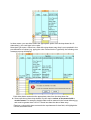
1
Atlas User Manual
(covering the Search, Import spreadsheet, Codes and Species
menus)
for Registered and Licensed Users
Version 1.2
© Copyright State of NSW and the Office of Environment and Heritage NSW
With the exception of photographs, the Office of Environment and Heritage NSW and State
of NSW are pleased to allow this material to be reproduced in whole or in part for educational
and non-commercial use, provided the meaning is unchanged and its source, publisher and
authorship are acknowledged. Specific permission is required for the reproduction of
photographs.
The Office of Environment and Heritage NSW (OEH) has compiled this handbook in good
faith, exercising all due care and attention. No representation is made about the accuracy,
completeness or suitability of the information in this publication for any particular purpose.
OEH shall not be liable for any damage which may occur to any person or organisation
taking action or not on the basis of this publication. Readers should seek appropriate advice
when applying the information to their specific needs.
Published by:
Office of Environment and Heritage
59-61 Goulburn Street
PO Box A290
Sydney South 1232
Report pollution and environmental incidents
Environment Line 131 555 (NSW only) or
See also www.environment.nsw.gov.au
Phone (02) 9995 5000 (switchboard)
Phone 131 555 (environment information and publications requests)
Phone 1300 361 967 (national parks, climate change and energy efficiency information and
publications requests)
Fax: (02) 9995 5999
TTY: (02) 9211 4723
Email: [email protected]
Website: www.environment.nsw.gov.au
ISBN 978 1 74293 698 7
OEH 2012/0509
Last updated: 6 November 2012
Contents
1. Introduction
5
2. Background
5
2.1 What is the Atlas of NSW Wildlife?
5
2.1.1
Where does all the data come from?
5
2.1.2
Limitations
7
2.1.3
Access to data in the Atlas system
8
2.2 Governance and accountabilities
2.2.1
Who to contact
8
8
3. Apply for login access
9
3.1 Levels of access
9
3.1.1
General Public access (no login required)
9
3.1.2
Registered Public access
9
3.1.3
Access for clients who hold an Atlas Data Licence
9
4. Getting started
11
4.1 How to login
11
4.2 How to logout
12
4.3 Useful buttons and warning advice
13
5. Data entry
14
5.1 Background to different types of records
14
5.1.1
Non-survey data
14
5.1.2
Systematic survey data
14
5.2 Background to data entry
14
5.3 Submitting non-survey data for entry via the Import spreadsheet menu
15
5.3.1
Background
15
5.3.2
Enter records into the ‘ScientificLicenceDatasheet.xls’ file.
16
5.3.3
Submit your file for import
24
5.3.4
Troubleshooting for Import submissions
38
5.3.5
How are records finally imported into Atlas?
39
6. Search
40
6.1 Background information to be read prior to searching
40
6.1.1
Why is data provided under a licence agreement?
40
6.1.2
Disclaimer / Reference for Atlas data
40
6.2 Start searching
41
6.2.1
Select search criteria
41
6.2.2
Review results
50
Atlas User Manual – Licensed Users
iii
6.2.3
Map records
54
6.2.4
Save species list
64
6.2.5
Download records
67
7. Codes and species
7.1 Codes
7.1.1
72
72
Search on an existing code
7.2 Species
72
73
7.2.1
Search for an existing species
73
7.2.2
Review an existing species
73
8. Glossary
79
List of figures
Figure 1 - Useful buttons
13
Figure 2 - Warning advice
13
Figure 3 - Tips and troubleshooting when entering values into the AtlasDatasheet.xls 20
List of tables
Table 1 - Import spreadsheet fields
20
Table 2 - Print pop-up fields
61
Table 3 - Fauna species maintenance fields
74
Table 4 - Flora species maintenance fields
76
Atlas User Manual – Licensed Users
iv
1.
Introduction
This manual provides a step by step guide for registered and licensed users to access and
submit sightings in the Atlas of NSW Wildlife Database.
The manual covers the following modules available through the Atlas of NSW Wildlife webbased application:
•
•
•
•
Search – search on existing sightings to create reports and maps.
Import spreadsheet - submit non-survey datasets via a standard spreadsheet for
import into Atlas.
Codes – view all values associated with individual Atlas codes (e.g. Observation
type).
Species – view taxonomic details for fauna and flora species.
Please note that separate manuals are available for the;
•
•
Fauna Survey module, and
VIS Flora Survey module.
2.
Background
2.1
What is the Atlas of NSW Wildlife?
The Atlas of NSW Wildlife (Atlas) is the Office of Environment and Heritage’s (OEH’s)
corporate database of flora and fauna records. It serves as the portal for supplying NSW
government-held information to biodiversity informatics initiatives, such as the
Commonwealth’s Terrestrial Ecosystem Research Network (TERN) and the Atlas of Living
Australia (ALA). The Atlas contains sightings of plants, mammals, birds, reptiles, amphibians,
some invertebrates (generally those threatened in NSW), some fungi (generally those
threatened in NSW) and some fish. Essentially any species that has been taxonomically
described can be included.
The Atlas database comprises a number of modules including the Fauna Survey module and
the VIS Flora Survey module (previously known as “YETI”). The VIS Flora Survey module is
one of the components of OEH’s distributed Vegetation Information System (VIS). The other
components of the VIS are physically separate from the Atlas, and include VIS Map
Catalogue, and VIS Classification (previously known as the NSW VCA database).
The Atlas database has existed in various formats since the 1980’s. It was originally
developed by the NSW National Parks and Wildlife Service to store vascular flora and
vertebrate fauna sightings recorded by NPWS staff and also store unusual sightings reported
from members of the public. The Atlas covers all of NSW and may include some records
from neighbouring states, though it is not a comprehensive inventory of all species, or all
locations of species in NSW.
2.1.1 Where does all the data come from?
The records in the Atlas of NSW Wildlife come from a number of sources, including:
•
•
•
survey sightings records from the Atlas’s in-built flora and fauna survey modules
records from consultants, research scientists and others as part of the Scientific
Licence procedure
incidental sightings records from the public, and
•
records from other custodians including the National Herbarium of NSW, the
Australian Museum, Forests NSW, NSW Fisheries and the Australian Bird and Bat
Banding Scheme, that have licensed OEH to distribute their data.
The scientific licence procedure
To carry out a flora or fauna survey in NSW, a Scientific Licence needs to be entered into
between the surveyor and OEH (Section 132(C) of the National Parks and Wildlife Act 1974
(NPW Act)), for:
•
•
•
fauna surveys, where there is the potential to harm protected species, either directly,
e.g. through the use of sampling devices such as traps or hair tubes or indirectly e.g.
through the accidental transfer of disease into frog habitats
flora surveys, where samples are taken from protected plants (listed under the
Schedules of the NPW Act) or from threatened flora species, endangered
populations or endangered ecological communities (listed under the schedules of
the Threatened Species Conversation Act 1995 (TSC Act))
surveys proposed on lands gazetted under the NPW Act or within critical habitat
declared under the TSC Act.
It is a condition of this licence that a full report of all species records collected during surveys
is provided back to OEH for inclusion in the Atlas database. Where the area to be surveyed
is on private land, it is the responsibility of the person who has signed the Scientific Licence
intending to carry out the work, to inform the landholder of this condition. No other clauses
can over-rule this agreement (e.g. after signing a scientific licence, the licencee cannot argue
that they are bound by a confidentiality agreement with a landholder which prevents them
from passing survey data on to OEH). Note that some surveys such as bird surveys are noninvasive and therefore will not require a Scientific Licence, though such surveys that include
call playback probably will.
Part 1 of the Reporting requirements of the Scientific Licence lists the required details and
format to record sightings, as well as the process by which records must be submitted.
Scientific Licence Reporting Requirements (Part 1)
It is a requirement of all S132c licences issued that a full report of the actual work carried out
under licence be submitted at the end of the licensing period and before any renewal will be
granted. The report must include;
(a) details of ALL animals, plants, materials or activities, collected, captured, observed or
undertaken under the licence including
(b) species identification
(c) precise locality description
(d) precise geographic coordinates (AMG/MGA or latitude/longitude) including datum,
accuracy and whether a GPS was used), and
(e) date of trapping, observation or collection.
(f) A list of locations surveyed (including geographic coordinates) must be included for
those licences authorising flora and fauna surveys.
(g) Data must be provided at an accuracy of not less than 100m without suitable
justification.
(h) Reports must be in the standard OEH excel format, available at
http://www.environment.nsw.gov.au/resources/Atlas/AtlasDatasheet.xls
(i) Completed reports are to be uploaded online, under a secure login. Contact
[email protected] for account details and guidelines.
Atlas User Manual – Licensed Users
6
(j) Failure to submit a valid and full report will delay or prevent the renewal of a licence
and may also incur an infringement notice for a breach of licence conditions ($300).
(k) Failure to submit a report may be considered sufficient grounds for cancelling a
licence.
Scientific licensing is managed by the Wildlife Licensing and Management Unit (WLMU) and
is a separate agreement from the Atlas of NSW Wildlife Data Licence.
More information on the Scientific Licence conditions can be found at:
www.environment.nsw.gov.au/wildlifelicences/ScientificResearchLicences.htm
2.1.2 Limitations
When accessing data from the Atlas, it is important to be aware of the limitations of the data.
The Atlas is not comprehensive
Data in the Atlas, while extensive, is by definition patchy and as such will not provide you
with the full distribution of a species. Except in areas where comprehensive survey
information has been incorporated into the database, the search results for a particular
area are based on a mix of reported sightings.
Data collection is often biased
Some areas are particularly poorly represented e.g. there are relatively few records for
flora species in western NSW, and there are relatively few records across the state for
fauna or flora sightings on private land. Sightings may follow patterns of human
movement, such as along roads, and contributors (not bound by the requirements of a
Scientific Licence) can often focus their efforts on recording threatened or rare species.
As a result common and introduced species can be under-represented.
Data is not necessarily an accurate representation of current abundance
It is important to realise that the number of recorded sightings for a species does not
necessarily correspond to the actual abundance of that species in NSW. A lack of
sightings of a species at a particular location does not necessarily indicate its absence,
just the same as multiple records of a species at a location doesn’t necessarily mean the
species is abundant (e.g. could be a single plant recorded on multiple dates by different
people, with slightly different coordinate readings).
Records are a mix of both historical and current data, and as such, are not intended to
be a current snapshot for an area or species.
The accuracy of individual locations vary
Due to the differing methods to collect records, there is variation in the accuracy of the
location at which records are collected. The locations of some species are collected via a
GPS and will therefore be accurate to 10 to 50 metres. While some records collected
outside of the Scientific Licence process (such as species lists for properties, or
historical records from published documents) can be quite coarse.
The Atlas database does not contain certain types of information
•
•
The Atlas is a database of the presence of individual species so does not record or
report on species absence (except for survey sites recorded in the survey modules of
Atlas), and
With the exception of records that are tagged as being part of an Endangered
Population, information on entities other than species (i.e. threatened ecological
communities and key threatening processes) are stored in the TS Profiles module of
Atlas. While these details are available via the Search module, individual records of
communities and threatening processes cannot be entered.
Atlas User Manual – Licensed Users
7
•
Critical habitat is not contained in the Atlas. Spatial information for Critical Habitat is
available via the register of declared critical habitat or via the OEH data download
site.
The Atlas is not guaranteed to be free from errors
The Atlas may contain errors. If you suspect an error in any Atlas record, please notify
the WDU by supplying the Unique Sighting Key and details regarding the field in
question (e.g. species name, location description/coordinates).
2.1.3 Access to data in the Atlas system
Sensitive Species Data Policy and the GIPA Act
Access to data held in the Atlas system is governed by:
•
The Government Information (Public Access) Act 2009 (GIPA Act).
Under this Act, all government-held information should be accessible to the public and
information should only be withheld if it is necessary to do so in the public interest.
•
OEH’s Sensitive Species Data Policy
“Sensitive” species are those threatened flora and fauna species which are identified
under the Sensitive Species Data Policy as being particularly sensitive to threats such as
collection or disease. Precise locational data for sensitive species is not made publicly
available by OEH, and this information is exempt from disclosure for the purposes of the
GIPA Act.
Restrictions on release of personal information
As a public sector agency, OEH is bound by the Privacy and Personal Information Act 1998
(NSW). Contributors providing sightings records are asked for personal details, to allow
checking and verification of sightings records, but OEH does not release sighting observer
details to third parties.
This restriction does not apply to survey datasets stored in the VIS Flora Survey module and
Fauna Survey module, where observer names are available to clients with an Atlas login,
and contributors are reasonably likely to be aware that this information might be disclosed.
2.2
Governance and accountabilities
2.2.1 Who to contact
The Wildlife Data Unit’s role is primarily the day-to-day management of the Atlas, which
covers the maintenance, importation, validation and supply of data. We can be contacted by
a share e-mail at [email protected].
Atlas User Manual – Licensed Users
8
3.
Apply for login access
Apply for login access via the Bionet homepage www.bionet.nsw.gov.au. Apply by clicking on
the Apply for a login link and completing the required details. Your information will then be
sent via e-mail to the WDU, who will then get back in touch with you to provide your account
details, or if further clarification is sought.
3.1
Levels of access
The Atlas system has different levels of user-access, as described below.
3.1.1 General Public access (no login required)
The majority of the data held in Atlas is made available to the general public by OEH, via the
BioNet-Atlas, VIS and Threatened Species websites. However precise location information
for “sensitive” species, and observer names for sightings, are not publicly disclosed:
•
•
•
3.1.2
In the public Atlas search module, records for category 2 sensitive species are
denatured to 0.1 degrees (~ 10km); records for category 3 sensitive species are
denatured to 0.01 degrees (~ 1km). Location description notes are not provided.
In the public VIS Flora survey module, records for category 2 and 3 sensitive
species are withheld.
There is no public access to the Fauna survey module to query the underlying site
information, although the Search module will return all relevant species records
contained in the Fauna survey module.
Registered Public access
Members of the public who do not require access to precise locational information for
sensitive species, but who require access to some of the more specialist functions of the
Atlas system, may register for non-licensed login access. Registered users can:
•
Access the Import spreadsheet, Species and Codes modules, in order to upload
sightings spreadsheets (for example to fulfil Scientific Licence requirements).
•
Query the TS profiles module, which contains profiles of threatened species,
populations and communities and information about key threatening processes. This
information is also available, without login, via the public Threatened Species and
BioNet –Atlas websites.
•
Access the Data Analysis function of the VIS Flora Survey module, to export data
and carry out data analysis.
3.1.3
Access for clients who hold an Atlas Data Licence
Parties who hold an Atlas Data Licence are provided with licensed login access to the
database. The Atlas Data Licence is renewed annually and user access permissions are
checked and updated at this time. There are two categories of licensed clients:
(a) General •
•
•
Clients have access to all the modules available to registered users i.e. Atlas
Search, VIS Flora survey (including Data Analysis), Import spreadsheet, Codes,
Species and TS profiles.
In addition, clients have access to the Fauna survey module.
In the Atlas Search module, location notes are available except for records of
category 2 sensitive species.
Atlas User Manual – Licensed Users
9
•
•
•
•
Records for category 3 sensitive species are available at ‘as-held’ accuracy in the
sightings and survey modules; and location description notes are available for these
species.
Records for category 2 sensitive species are denatured to 0.01 degrees (~ 1km) in
the Search module, and location description notes are withheld for these species.
Records for category 2 species are not available in the survey modules (which
record multiple species at a single site).
No observer details are available in the sightings module; observer information is
available in the survey modules.
(b) Licensed users with survey data entry rights
Users who, in addition to holding an Atlas Data Licence, have been assigned survey
data entry/edit rights (linked to login) pursuant to signing an Atlas Survey Data Provider
Agreement.
Conditions as for General licensed users, as well as:
•
•
•
clients are authorised to enter survey data into the VIS Flora Survey and Fauna
Survey modules.
clients have access to records for category 2 sensitive species at ‘as-held’ accuracy
in their own survey datasets.
clients have edit rights to their own survey datasets*
*note that clients do not have data entry/edit rights for observer information. Due to
privacy issues, the observer table is maintained by the Atlas system administrator. Atlas User Manual – Licensed Users
10
4.
Getting started
4.1
•
How to login
Once you have received account access from the WDU, go to the Bionet website
and click on the Login here link button.
You will then be directed to OEH’s online security portal (as shown below).
•
Enter your user name and password* and click on the
button.
* Note that your password is case-sensitive.
The following Atlas homepage will appear, providing you access to various modules via dropdown menus.
Atlas User Manual – Licensed Users
11
4.2
How to logout
Once you have finished with your Atlas session, you can either;
•
•
close the Windows Internet Explorer session (as you would any internet session) and
you will be logged out automatically, or
click on the Logout menu.
You will then be re-directed back to the OEH online security portal login page.
Note that if after logging out, you subsequently login, you will be directed to the following My
applications page listing all the applications that you have access to.
•
Click on the
link button to be directed to the Atlas homepage.
Atlas User Manual – Licensed Users
12
4.3
Useful buttons and warning advice
Figure 1 contains useful tips when using the application, while Figure 2 contains warnings for
issues you may encounter.
Note the group of buttons under the Logout menu.
allows you to reduce the font size.
allows you to increase font size.
allows you to print the screen.
This timer relates to the secure login software that you need
login to, to be able to access Atlas. Certain processes (such as saving information)
send a message to the server and the timer is automatically reset for another 60
minutes. To avoid losing half entered work, prior to the 60 minute timer expiring, you
can click on this Reset timer button at any time to refresh the timer for another 60
minutes.
Throughout the application:
Help hot-links are displayed for some fields. Click on the help hot-link to display
a pop-up containing advice on selecting values in a particular field.
The percentage sign (%) is the wildcard. Entering the % value into any search field
will return all available values. Warning that for some fields, this can return a large
number of results and therefore may be quite slow.
Figure 1 - Useful buttons
Browser environment and operating systems
The Atlas application was built for optimal performance using IE v8 and IE v9 on
Windows XP. The functionality of the Atlas application using alternative browsers or
operating systems may be patchy. Unfortunately the submit function under the
Import spreadsheet menu option does not currently work at all using Firefox.
In Firefox, Chrome and Opera pressing the Enter key will attempt to save/submit
your entries before you are ready to. For example, in the Search menu, if you are
entering fields to search on and you click the Enter key before selecting all of your
criteria, the system will attempt to submit the search. Use the Tab key to move
between cells (Tab to move to the next sequential cell, and Shift and Tab to move
backwards), or use your mouse to click in the cells as necessary.
Back arrow
Clicking on your browsers back arrow button may kick you out of the current Atlas
session.
Mapping help
To view any maps (in the Search, Import Spreadsheet and Species menus)
ensure you have Adobe Flash installed. To print maps in pdf format, you will need
Adobe pdf reader.
Figure 2 - Warning advice
Atlas User Manual – Licensed Users
13
5.
Data entry
5.1
Background to different types of records
How a record was collected will dictate how it will be entered into the database. Data are
collected in either of two general formats; non-survey or survey.
5.1.1 Non-survey data
Non-survey data refers to anything from a one-off sighting, to a species list compiled for a
park or property. All non-survey data is entered via the Atlas Sightings menu. At an
absolute minimum, all records will need to have the following information;
•
•
•
•
•
species name
date of observation
location details
observer name, and
observation type (for fauna only).
However there are many more fields for which information can be attributed for an individual
record.
5.1.2 Systematic survey data
Some additional modules have been incorporated into the Atlas to allow for the recording of
additional records and fields collected through systematic surveys.
Fauna survey data
Fauna data collected from systematic surveys is entered into the fauna survey module.
While systematic survey data can include a range of additional information such as additional
location information and details of species weight/measurements etc, what sets it apart from
non-survey data is the recording of survey effort (i.e. number of traps per night; number of
people hours involved) and the ability to infer negative data (i.e. absence data or sites
where sightings were not made). Refer to the Fauna Survey module user manual for further
details.
Flora survey data
Flora data collected from systematic surveys is entered into the VIS flora survey module.
Historically flora survey data was stored in a series of stand-alone Access databases (known
as YETI). Refer to the VIS flora survey module user manual for further details.
5.2
Background to data entry
When you are given a login to the Atlas system, as either a Registered or Licensed user, you
gain access to the Import spreadsheet module of the Atlas system.
The Import spreadsheet module allows you to submit sightings online via the Atlas
spreadsheet, and enables your records to be identified to your Scientific Licence number.
If you want to enter complete systematic survey data into either the VIS flora survey or fauna
survey data modules, you will need to be a Licensed user and also to have signed an Atlas
survey data provider agreement. Please contact the WDU for more information.
Atlas User Manual – Licensed Users
14
5.3
Submitting non-survey data for entry via the Import
spreadsheet menu
5.3.1 Background
To facilitate validation and import of datasets collected pursuant to a Scientific Licence, the
Atlas offers the functionality to submit records online via the Import spreadsheet menu.
The process for submitting data covers 4 steps:
a.
b.
c.
d.
enter records into the spreadsheet, then save as a comma separated file (.csv)
log into Atlas and submit the file
review the online validation to ensure the submission was successful, or
if prompted, address any fields requiring further validation and re-submit the file until the
submission is successful.
The data will be stored in a ‘waiting area’ of Atlas. Only those files that have been
successfully submitted will be reviewed by the WDU, to review and authorise the import.
Important advice around submitting records for import
1. Choose how frequently you wish to submit data. While datasets have
historically been collated and submitted on a yearly basis (to coincide with the SL
renewal), please note that you can submit data as frequently as you wish. You may
choose to enter your “full” dataset as a single file (at the time of your SL renewal); or
as multiple files over time as the data is collected. Just make sure you enter your
Scientific licence number in the relevant field on the submission form whenever you
submit a file. And please keep a record of file names and dates of submission, in
order to notify Wildlife Licensing when your Scientific Licence is next due for
renewal.
2. Only submit datasets once*. Please only submit new sightings once. This
applies to both;
a) records you have previously submitted. If, for example, you have decided to keep
all of your records for the year in a single spreadsheet and you decide to submit
records periodically throughout the year (at the end of each project, for example),
please only submit the new records. Submitting the same records twice will be
flagged as duplicates, but only after unnecessary effort by WDU staff.
b) records that someone else has collated for you under their Scientific Licence. The
general rule here would be that the individual who has collected records pursuant to
their Scientific Licence is responsible for collating and submitting the records
themselves. If, for whatever reason, you have agreed to submit the records on their
behalf (such as in the case that you have sub-contracted them to do the survey for
you), then if the agreement between both of you is that you shall submit the records,
please be clear to ensure that only one of you submits the records and also clearly
advise Wildlife Licensing of this at the time of the Licence renewal.
*Note that this does not apply to datasets you submit online that fail validation due to
missing/erroneous values. Datasets may need to be submitted several times until
they pass validations
3. Advise WDU ASAP regarding any valid submissions that should not be
imported. If, for example, you have successfully submitted a file online (i.e. Status =
‘Ready for import’) but you later realise that it is the wrong dataset you meant to
upload (e.g. duplicate, or contains missing details etc), then please e-mail WDU
asap with the file name and date of submission, so that we can flag the file as ‘not
for import’. Any datasets with a Status of ‘Invalid’ will not be reviewed or imported by
WDU, so there is no need to advise WDU of such datasets.
Atlas User Manual – Licensed Users
15
5.3.2 Enter records into the ‘ScientificLicenceDatasheet.xls’ file.
The following outlines guidelines for entering details of your species records into the
spreadsheet.
•
•
Save a copy of the file ‘ScientificLicenceDatasheet.xls’ to your local/share drive.
Note that the file is over 9MB, due to the embedded formulae and reference data. It
will substantially reduce in size once you are prompted to re-save it in a different
format (i.e. as a .csv file).
Open the ScientificLicenceDatasheet.xls file. Note that there are 2 worksheets;
a. Sighting records – this is where all the sightings details are entered.
Details of each field and the input requirements are contained in Table 1.
b. Reference – this contains the codes and descriptions for each of the fields in the
Sighting records worksheet. The reference worksheet is needed to ensure validation
(on entry into the excel file) of values in the Sighting records worksheet.
Atlas User Manual – Licensed Users
16
•
Enter the details of your species into the spreadsheet. Before referring to Table 1
for descriptions and requirements of individual fields, please review the following steps
which outline the overall requirements and process for data entry;
Only a few fields in the Sighting records worksheet are mandatory. These are highlighted in
yellow. The first two mandatory fields are shown below.
Once data is entered into these fields in the correct format, the cells will automatically
become white, as shown following.
There are different requirements for entry into cells, dependent on the field;
a. Some fields require a value to be selected from a pre-determined list. For example
clicking in the cell will display a drop down arrow, which when clicked on, displays the
full set of value options, such as illustrated for the field Type, shown following.
Atlas User Manual – Licensed Users
17
In these cases, you can either select the appropriate option from the drop-down list. Or
alternatively, you could type in the value.
Note that if you enter a value into a field with a drop-down menu that is not contained in the
pre-defined list of values (e.g. typing the value Fauna into the Type field), the following error
message pop-up will display;
Click either button and select the appropriate value from the drop-down list.
b. Some cells do not have drop-downs, but still require values to be entered with a
certain format. For example, the date field must be entered in the format dd/mm/yyyy
and must be greater than 01/01/1770 and less than the date of data entry.
Entering a value which does not match the requirements for that field, will highlight the
cell red, as shown below.
Atlas User Manual – Licensed Users
18
You will need to edit the values to the correct format before the cell will display as white.
c. Some cells allow free text, such as the Notes, Specimen Rego and External Key fields
as well as fields that allow multiple values (e.g. Breeding codes). Keep in mind that
while these cells may allow you to type anything into the cell in the excel file (without
highlighting red), you still need to be mindful of entering a value in an acceptable
format. In the case of Breeding codes this would involve referring to the values in the
reference worksheet to ensure you enter the correct code(s). In the case of fields such
as Notes, Specimen Rego and External Key, this means ensuring that the text does not
exceed the maximum cell length. Exceeding the maximum allowed length for the cell
will result in a truncation of data post import. Table 1 contains details of the required
format for all fields.
d. Some cells become mandatory in certain conditions, such as;
o
after a value has been entered into a related field (e.g. entering a value into the
Specimen Rego field will cause the Specimen location field to highlight yellow
(and visa versa)). Note that this particular example will also cause the Source
code field to highlight red, prompting you to change the value to indicate where
the specimen has been lodged (a public or private museum or herbarium).
Figure 3 contains some tips and troubleshooting when entering values into the Atlas
datasheet.
Atlas User Manual – Licensed Users
19
TIPS and TROUBLESHOOTING when entering values into the
AtlasDatasheet.xls
1. When entering sighting details, always enter the first record into Row 4 and do
not skip any rows or enter values unrelated to sightings into other cells elsewhere in
the spreadsheet.
2. If add value with a single apostrophe in Title or Notes fields, the apostrophe will
be exported and stored as a question mark in the database. If practical, please
refrain from using apostrophe’s in these fields.
3. When entering values into some cells, you may notice that sometimes the value
appears to repeat on itself. Please note that this issue does not affect the cell (check
the cell formulae bar to see that only the characters you have typed in display
exactly as entered).
4. If you are copying across data from old excel files, into the new
‘AtlasDatasheet.xls file, please be aware that there may be an issue with the First
Date and Last Date fields whereby the dates are re-formatted to numeric (and as a
result no longer resemble the date). Please keep this in mind and check the date
fields in ‘AtlasDatasheet.xls’ after pasting values from other files.
5. Always enter new datasets into the .xls file, to ensure appropriate validation (i.e.
not the .csv file). Entering new records into the .csv file will compromise the inbuilt
validations. Editing the .csv file converts the species code field to numeric, thereby
removing the ability to store leading zeros resulting in many species codes being
submitted in error.
Figure 3 - Tips and troubleshooting when entering values into the AtlasDatasheet.xls
Only after there are no red or yellow cells, is the file ready for submission to import
Table 1 contains descriptions for each of the fields in the Atlas spreadsheet, and the required
format for entry. Mandatory fields are highlighted in bold. (Refer to the footnote for an
explanation of the asterisk).
Table 1 - Import spreadsheet fields
Description
Required format
Index
A sequential number.
Integer.
Type
Distinguishes fauna (FA) from flora (FL) species. Note that
fungi is included under FL.
Select from drop-down list.
Species Code
A unique code attributed to an individual species, genus, or
family.
Codes can be obtained from the Census of Australia
Vertebrate Species (CAVS) and Census of Australian Plant
Species (CAPS) library fields.
Please note that entry of codes is not required as this can be
calculated by WDU, so long as the species Scientific and/or
Common name is provided.
Unique letter/number (see
CAVS and CAPS lists).
Common
Name*
The common name by which the species is known.
Free text, up to 80
characters.
Scientific
Name**
The scientific name by which the species is known.
Free text, up to 80
characters.
First Date
The date the species was sighted. Time is optional.
dd/mm/yyyy hh:mm.
>/= 01/01/1770.
Last Date
For species recorded on a specific day, you can leave this field
blank (it will be automatically populated with the value from the
dd/mm/yyyy hh:mm.
Later than or equal to First
Date
Species
Field
Atlas User Manual – Licensed Users
20
Number
First Date field).
For species recorded over a period of time (e.g. during a
survey conducted over a week, or where an approximate date
was given), enter the Last Date.
Date, and </= date of data
submission.
Count
The total number of individuals.
Integer, > 0.
Estimate Code
The accuracy of the Count (e.g. exact, estimate, more than, or
less than).
Select from drop-down list.
Sex Code
The sex of the species.
Select from drop-down list.
Breeding Code
Details of the Breeding status of the species. See Reference
worksheet for available values and definitions.
Note different breeding codes for fauna versus flora.
Multiple codes separated
by either;
Source Code
Source distinguishes standard sightings from those held at
public or private collections. The default value for this field is
set to Sighting only, which will be automatically populated once
a value is entered into the Type field. You only need to change
the value if a specimen was taken (i.e. either Specimen with
public museum or herbarium or Specimen with other
collection), or if there is some uncertainty around the
identification, particularly in the case of Anabat records (i.e.
Sighting – probable ID or Sighting – possible ID).
See reference worksheet for values and definitions.
Select from drop-down list.
Datum
Defines the coordinate system. Refer to the Geoscience
Australia website for an explanation of datums;
www.ga.gov.au/earth-monitoring/geodesy/geodeticdatums/about.html
Select from drop-down list.
GPS
Whether a Global Positioning System (GPS) was used to
obtain the coordinates.
Select from drop-down list.
•
•
•
•
•
comma,
comma and space,
space,
semicolon, or
semicolon and
space.
Total character length
</= 100.
Coordinates are a reference for any point on the earth’s surface and can be supplied as either Projected
(Zone, Easting, Northing) or Geographic (Latitude, Longitude).
Zone
•
•
•
•
o
o
Zone 56 is 150 – 156 longitude, which encompasses
much of eastern NSW.
o
o
Zone 55 is 144 – 150 longitude.
o
o
Zone 54 is 138 – 144 longitude, encompassing most
of Western NSW.
Zone 57 covers Lord Howe Island.
Select from drop-down list.
Easting
The reference in metres, measured east of an arbitrary origin
(also referred to as the x-coordinate).
A six digit number, with up
to four decimal places.
Northing
The reference in metres, measured north of an arbitrary origin
(also referred to as the y-coordinate).
A seven digit number, with
up to four decimal places.
Location***
Readings of latitude and longitude can either be provided as degrees, minutes, seconds or as decimal
degrees. Decimal degrees are the preferred format.
Latitude
The position South of the Equator, measured in decimal
degrees.
>/= -40, </= -20.
Longitude
The position East of the Greenwich meridian, measured in
decimal degrees.
>/= 138, </= 162.
Latitude
Degrees
Atlas User Manual – Licensed Users
Integer, >/= -40, </= -20.
21
Specimen details***
Latitude
Minutes
Integer, between 0 and 60
Latitude
Seconds
Numeric, between 0 and
60
Longitude
Degrees
Integer, >/= 138, </= 162.
Longitude
Minutes
Integer, between 0 and 60
Longitude
Seconds
Numeric, between 0 and
60
Accuracy
How accurately the coordinates represent the exact location of
the species (in metres). For example a value of 100 would
mean that the location is accurate to the nearest 100 metres.
Integer,
>/= 1 and </= 100,000,
with no more than four
decimal places.
Location
Description
Detailed description of the geographic location, such as street,
nearest cross street, town, landmark or reserve.
Free text, no character
limit.
Altitude
The height of the location from sea level, in metres
Integer,
>/= 0 to </= 2500.
Geology Code
See reference worksheet for Geology values and definitions.
Select from drop-down list.
Vegetation
Code
See reference worksheet for Vegetation Code values and
definitions.
Select from drop-down list.
Slope
Measured in degrees, from the horizontal.
Integer, between 0 and
90.
Aspect
Measured in degrees, starting from zero as North and then
going in a clockwise direction. E.g. East = 90
Integer, between 0 and
359.
Location Notes
Enter any additional notes regarding the location that do not fit
within any of the other existing (location related) fields.
Free text, no character
limit.
Observer
Name
Name of the person who recorded the species.
Multiple names allowed,
separated by any delimiter
(i.e. space, comma,
semicolon etc).
Free text, up to 500
characters.
Specimen
Rego
The Specimen Rego refers to the unique registration number
assigned by the Herbarium/Museum where the specimen is
lodged. Note that this is not the Inquiry number. If the
specimen number is not available at the time of submitting your
record to the Atlas, write ‘not provided’ and you can forward the
Registration after you receive it.
Free text, up to 40
characters.
Specimen
Location
If a specimen has been lodged at a Herbarium or Museum
select the location.
Select from drop-down list.
Note: After entering specimen details, please update the Source field by selecting the appropriate value, either;
•
•
1 - Specimen with Public Museum or Herbarium, or
2 - Specimen with Other Collection
Atlas User Manual – Licensed Users
22
Height
Reference*****
External Key
Observers' own unique reference number.
Free text, up to 30
characters.
Notes
Enter any additional details regarding the species that could
not be entered into any of the other existing (species related)
fields.
Free text, no character
limit.
Observation
Type****
(For fauna only) Refers to how the species was observed (e.g.
observed, heard, scat). If more than one observation type was
recorded, select the most reliable observation type here, then
enter additional values in the Notes field.
Select from drop-down list.
Microhabitat
Type
Small-scale habitat, e.g. on ground or in tree.
See reference worksheet for Microhabitat type values and
definitions.
Multiple codes separated
by either;
Lower Height
The height (in metres) of the shortest plant.
Number, up to two
decimal places.
Must be less that the
Upper height value.
Upper Height
The height (in metres) of the tallest plant.
Number, up to two
decimal places.
Must be greater than the
Lower height value.
Growth Habits
Whether the plant is a tree, herb, fern etc.
Select from drop-down list.
Title
If the record is sourced from or being included within a report,
include the Title of the publication.
Free text, up to 500
characters.
Author(s)
Author(s) of the publication.
Free text, up to 255
characters.
Publisher
Name
Name of publisher.
Free text, up to 60
characters.
Year of
Publication
Year of publication.
Integer, >/= 1770.
Type of
Publication
Type of publication (e.g. journal, book etc)
Select from drop-down list.
City of
Publication
City of publication.
Free text, up to 30
characters.
Name of Book
Name of book.
Free text, up to 150
characters.
Name(s) of
Editor
Name(s) of Editor.
Free text, up to 60
characters.
Volume of
Publication
Volume, and (if applicable) page numbers (e.g. 4:23-35)
Free text, up to 30
characters.
•
•
•
•
•
comma,
comma and space,
space,
semicolon, or
semicolon and
space.
Total character length
</= 100.
Fields in bold are mandatory
* Common Name is required for fauna, where the Scientific Name is not supplied. Common Name is
not required for flora.
** Scientific Name shall be required for fauna, where Common Name is not supplied. Scientific Name
is required for flora.
*** If Specimen Rego is provided, Specimen Location must be provided, and vice versa.
Atlas User Manual – Licensed Users
23
**** If Zone, Easting and Northing are not supplied; Latitude and Longitude OR Latitude Degrees,
Latitude Minutes, Latitude Seconds and Longitude Degrees, Longitude Minutes, Longitude Seconds
are required.
***** If any of the fields in Reference section are supplied, the fields Title, Author(s), Type of
Publication and Year of Publication are required.
5.3.3
Submit your file for import
Once all sighting details have been entered you are ready to submit your file for import. You
will first need to save your file in the correct format (a comma separated file; .csv)
•
•
In excel, make sure the Sighting records worksheet is the worksheet in your
current view.
select the Save As option from the File drop-down menu.
A Save As pop-up will appear.
•
In the Save As pop-up, select the file type .csv from the Save as type drop-down
menu.
Note that this will only save the worksheet in your view, the Sighting records worksheet (so
make sure this is your current worksheet).
Atlas User Manual – Licensed Users
24
•
•
Change the filename to whatever is meaningful for you.
Click Save.
A pop-up will display advising you that .csv files can only save the active sheet.
•
(as you no longer need the Reference worksheet).
Click
A second pop-up will now display advising you that the file may contain features that are not
compatible with CSV.
•
Click
.
The pop-up closes and the file has been saved.
Atlas User Manual – Licensed Users
25
Note that because the Reference worksheet is not stored in your .csv file, the file size will be
considerably smaller.
Your file is now ready to be uploaded via Atlas for submission.
•
Login to the Atlas using your secure login.
In the heading banner, note the menu heading titled Import spreadsheet.
•
Move your mouse over the Import spreadsheet menu to display the selection
Submit sightings.
A Submit sightings page will display.
The five fields available to populate are;
a.
b.
c.
d.
e.
Dataset
Supplied by
Scientific licence number
Import type
File
Following is advice for making selections at each of these steps.
WARNING Unfortunately the submit function under the Import spreadsheet menu
option does not currently work at all using Firefox.
If you are using Chrome and Opera, using the enter key after typing in text (instead
of clicking on the Search key) will cause the application to submit your file for Import
before you are able to enter values into the other fields. The following error message
will return:
Please ensure you click on the
button.
a. Dataset
Records in the Atlas are grouped according to datasets to which they belong. In order to
enter records, you will have been assigned access to specific datasets. Note that you can
have access to multiple datasets, but one dataset will be your default.
The default dataset to which all data files you submit for import should be set to OEH Data
from Scientific Licences dataset. If this field is blank, or a different dataset displays, you
will need to search on the OEH Data from Scientific Licences dataset. Keep in mind that
Atlas User Manual – Licensed Users
26
records collected as part of a systematic survey should always be entered via the
appropriate survey module.
Where OEH Data from Scientific Licences dataset does NOT appear by default in the
Dataset box, please do the following;
•
Click on the
button.
A Search for datasource pop-up window will display, allowing you to search on all Dataset
names linked to your account.
•
Type in all (or part) of the Dataset name and click on the
button.
Alternatively, you can also use the wildcard % to search on all datasets that you have
edit access to.
Atlas User Manual – Licensed Users
27
•
In the resulting list of datasets, select OEH Data from Scientific Licences dataset
by clicking on the
link button.
This will close the Search for datasource pop-up and insert the selected dataset name into
the Datasource tab folder.
b. Supplied by
This step is slightly different for Registered and Licensed users.
i. Registered users
•
In the Supplied by field, click on the
button.
A Search for Observer pop-up will display.
Atlas User Manual – Licensed Users
28
•
Enter % in either to Surname or Given name(s) fields and click on the
button.
An observer by the name of Registered user will display in the results list.
•
Click on the
link button.
You will then be returned to the Submit sightings page, where the Supplied by field is now
populated with the name Registered user.
Please note that even if your contact details exist in the system (either because you have
previously submitted sightings to the Atlas or have had a Licensed user account in the past),
you will not be able to search on your personal details as a Registered user. Only the name
Registered user will be available for you to select.
ii. Licensed users
The supplied by field allows you to identify the name of the ‘owner’ of the dataset. In most
cases this will be you (i.e. the observer of the records). Note that if you are submitting a file
on behalf of someone else, please select their name.
•
In the Supplied by field, click on the
Atlas User Manual – Licensed Users
button.
29
A Search for Observer pop-up will display.
•
Type in all (or part) of your Surname and/or Given name(s).
•
Click the
button.
All names that match your search criteria will display. Please note that the names available
for you to search on, are restricted based upon your login details. As a result you will only be
able to search on observers which are attached to your Atlas licence.
•
If there are multiple names that match your search criteria, you can click on the
button.
A pop-up displays with additional contact details for the observer.
Atlas User Manual – Licensed Users
30
•
Click anywhere outside of the pop-up to close it.
•
To choose your details, click on the
link button.
The Search for observer pop-up closes and your selected contact details are displayed in
the Supplied by field.
c. Scientific licence number
If the dataset (or part thereof) is being supplied pursuant to a Scientific Licence, the licence
number(s) should be recorded here.
•
Enter the licence number(s) in the Scientific licence number field (this is a free text
field, allowing up to 50 characters). Multiple licence numbers can be separated by a
space, comma or semi-colon.
Note that Scientific Licensing use the data from this field when renewing licenses to ensure
data has been successfully submitted before issuing a new licence. It is therefore important
that you do not leave this field blank if you are submitting records pursuant to your Scientific
Licence.
d. Import type
At the Import type, note the default selection is for Standard Import sighting.
Leave this as is for all non-survey data. Note that if you wish to upload systematic survey
data (either fauna or flora), please first discuss this with WDU.
e. File
Finally, to select your file for upload, look at the File upload box.
•
Note the help
•
If you click on the button, a pop-up reminds you that only .csv files can be uploaded.
•
Click on the
button.
Atlas User Manual – Licensed Users
button.
31
A Choose file to upload pop-up displays.
•
Use the Look in field to navigate to your file held on your local or hard drive.
NB: Unfortunately you cannot use the Files of type menu to filter on only .csv files.
Atlas User Manual – Licensed Users
32
•
Once your file has been selected, click on the
button.
The file pathway and filename will be listed in the File field and the field will automatically
highlight green.
Alternatively you can type the file name and pathway directly into the File field.
You may have noted that once the cell highlights green, the Submit button activates.
•
Click on the
button.
A Data processing pop-up displays.
While processing, your dataset is undergoing preliminary validations which include checking
that mandatory fields are filled in and values are entered in the correct format.
Once the database has validated the fields contained in your file, a Sighting submission
pop-up will display with details of your submission.
You will need to review both the Status and Log values to determine how next to proceed.
Generally you will receive one of two Status values;
a. Invalid, or
b. Submitted
Following is a summary of what these different Status types mean;
a. Invalid
If the Status type displays as Invalid, this indicates that your file contains erroneous or
missing data.
Atlas User Manual – Licensed Users
33
The Log will then identify which Row’s contain fields that require review and edits, with a
brief description of what edits are required, as shown in the example above. Note that the
Row number here refers to the row number in your excel file.
Note that only the first 100 errors will display in the log, if there are more than 100 error
messages, or you wish to review your messages at a later date, you will need to save the log
to view details.
•
Click on the
button
You will need to fix these errors in the Excel file. Editing the excel file ensures that the
formulae and reference worksheet validates any new values added.
•
•
•
Make any edits to the Excel file.
Resave the file as a .csv file
In Atlas, re-submit the .csv file for upload.
Repeat this process as necessary until the Status returns as Submitted.
b. Submitted
If the Status type displays as Submitted, this means that your submission has passed
almost all validations.
Atlas User Manual – Licensed Users
34
Note that the Sighting Submission pop up will include the following box;
The final step of the submission is to confirm that all of the locations within the file are valid
(i.e. the location description field and coordinates match up).
You have two options;
i. Check the locations via a map generated in Atlas, to confirm they are all valid, or
ii. Confirm that you have already checked the locations (via your own GIS software,
or other means) and they are all correct.
Following is a summary of each of these options;
i. Check the locations via a map generated in Atlas.
If you have not already checked the location descriptions against the coordinates for all
records (via your own GIS software, or other means) in your file, you can do this via the
online Atlas website.
•
Click the
button.
Note that a warning message appears advising you to wait while the map may take some
time to display.
Atlas User Manual – Licensed Users
35
A new window will then open, with a map zoomed to your locations.
•
•
•
For details on how to interact with this map and review details for individual records,
please refer to Section 6.2.3.
When you have finished checking the records, close the map window.
If any locations require correction, you will need to click the
Sighting submission pop-up.
button in the
The following pop-up will appear.
•
Click on the
button.
As a result the Status will automatically change to Locations invalid.
Atlas User Manual – Licensed Users
36
•
You will need to make the necessary corrections to your Excel file, re-save as a .csv
file, and submit the updated file via the Submit Sightings selection again.
When the file displays with the four highlighted areas, as follows, you are ready to continue
to step ii.
ii. Confirm that the locations are all valid
•
Click the
button.
The following pop-up will display;
Atlas User Manual – Licensed Users
37
•
Click on the
button.
The pop-up closes, the location validation box disappears and the Status will be set to
Ready for import.
Your file has now been successfully submitted and is awaiting review and import by WDU
staff.
•
Close the Sighting submission pop-up.
You do not need to do anything further.
NB: any files where the Status is listed as Invalid, will be ignored by WDU.
5.3.4
Troubleshooting for Import submissions
Note that you may receive a Status of Invalid, without any fields specified in the Log (as
shown in the following example)
Atlas User Manual – Licensed Users
38
This may occur because you have inadvertently entered a rogue value (such as a space or
letter) into another row.
If it is not immediately clear from looking at your .xls or .csv file as to what may be causing
the problem, please contact WDU for advice.
5.3.5
How are records finally imported into Atlas?
Once you have received a Status of Ready for Import in the Sighting Submission pop-up,
the file is stored in a staging area of the database, awaiting import. The records in the
staging area have not yet been assigned sighting keys and will not appear in any searches
you undertake.
The Wildlife Data Unit (WDU) are the only OEH staff that can finish the import process to
incorporate the records into the Atlas. Note that only those submissions flagged as Ready
for Import will be reviewed and imported by the WDU. All other submissions that have
returned as Invalid will be ignored.
The WDU routinely reviews and processes any files which are flagged ‘Ready for Import’.
For the file to be imported, this still involves further validation; i.e. random audits of locations,
assigning observer details, and species details (where necessary) and review of potential
duplicates, at which point WDU staff may contact you if further clarifications are required.
The WDU will work through imports by date of submission. If there is an urgency to have
your file imported, please just let the WDU staff know, otherwise it will be imported in due
time.
A note on Quarantine
Please note that the Atlas has inbuilt validation checks against species
distribution. Species entered for a location outside of their known / accepted
distribution within NSW will be saved to a quarantined section of the database,
pending review by WDU. Please be aware that if some of your records are not
viewable in the Atlas, it may be that they are stored in the Quarantined section of the
database, pending review.
Atlas User Manual – Licensed Users
39
6.
Search
Please note that this section relates to specialist users of the Atlas who have signed
a licence to obtain Atlas records, otherwise known as ‘Licensed users’. Licensed
users have a bona fide reason for obtaining a restricted version of the records
available via the Atlas search menu, which includes more precise locations of
species classed as ‘sensitive’, as well as some additional fields.
If you are accessing this Search menu as a ‘Registered user’, the Search results
will be exactly the same as for the Public user Search (i.e. searching from the
Search menu after logging in, will return the exact same information as if you were
to search via the Search menu publicly available via the Bionet homepage).
6.1
Background information to be read prior to searching
6.1.1 Why is data provided under a licence agreement?
Data is provided under licence to protect the locations of species, particularly those that are
sensitive, and to ensure that the appropriate data is accessed.
Your Atlas licence;
•
•
•
licenses you for your use of the Atlas system and the data you retrieve from it
enables multiple users within the one organisation to obtain access to the Atlas
under a single licence
defines the restrictions around mapping of records. This enables mapping of nonsensitive species at any scale. Should the user wish to produce a map which does
include sensitive species, they can either;
o
o
refine the scale to 1:250,000 or coarser, or
produce a map from the Atlas, via public user access, at any scale, where
locations of;
-
Category 2 sensitive species are denatured to 0.1° (approximately ten
kilometres accuracy), and
Category 3 sensitive species and denatured by 0.01° (approximately one
kilometre accuracy) for Category 3, by default.
The full conditions under which you can access and use data from the Atlas of NSW Wildlife
database, are available via the Atlas Data Licence.
6.1.2 Disclaimer / Reference for Atlas data
Disclaimer
When including species lists or maps generated from the Atlas, in reports, please ensure
that the standard disclaimers that are provided with the lists/maps are included.
Maps/reports made from the Data and that will be available to third parties must
acknowledge the source and the date the Data was obtained, as follows;
“NSW Office of Environment and Heritage’s Atlas of NSW Wildlife, which holds data
from a number of custodians. Data obtained dd/mm/yyyy”.
Reference
The Atlas of NSW Wildlife should be cited or referenced in any bibliography as follows;
“NSW Office of Environment and Heritage (<insert year>) Atlas of NSW Wildlife
database. Data accessed <insert dd/mm/yyyy>.”
Atlas User Manual – Licensed Users
40
6.2
Start searching
6.2.1
•
Select search criteria
Click on the Search menu.
A new window containing the Atlas search page returns.
Tip
The Reset time box
which displays on the Atlas login page,
continues to count down after the new Search window opens. This means that if you
intend to use the Search page for more than 1 hour, your Atlas session could time
out while you are in the middle of a search. To avoid this happening, click on the
reset timer button before the clock expires.
The Search page is displayed as a single page with radio-buttons and drop-down lists to
select your search criteria. Before beginning a search, please refer to Section 4.3 to review
helpful advice and warnings.
Atlas User Manual – Licensed Users
41
There are four steps at which you can input criteria to refine your search. Note that each step
has an information button
which is located to the left of each step number.
•
Left mouse click once on the
button, to display a text box underneath the
heading with more information about this field. As an example, the info box for the
first step is displayed below.
Enter values into each of the four steps, as follows:
1. Which species or group?
Choose one of the following eight options:
a. All entities
b. Animals
c. Plants
d. Fungi
e. Communities (threatened Ecological Communities, as listed under the TSC Act)
f. Threats (Key Threatening Processes, as listed under the TSC Act)
g. Endangered Populations (as listed under the TSC Act), or
h. Search for a species or group of species (e.g. birds).
If selecting a specific species or group:
•
Click on the last option ‘Search for a species or group of species (e.g. birds)’ to
display a search box:
•
Type in all (or part) of a Species (scientific or common name), Genus, Family,
Order or Class.
Click on the
button.
•
A Species pop-up appears listing all values that contain your search word. For example,
if you were to search on the word ‘bat’, the result list would include not only bat species
such as the Common Bentwing-bat, but also the Family Hydrobatidae, the Genus
Acrobates, the Grey Grasswren, Amytornis barbatus and the Antipodean Albatross.
Atlas User Manual – Licensed Users
42
•
Use the scroll-bar to scroll through the list and select the appropriate species.
On selecting the species, the Species pop-up will automatically close and the selected
species will display next to the ‘Term selected:’ text.
2. Legal Status?
Choose one of the following two options:
a. All records, or
b. Select records that fall under one or more categories
•
Clicking on the option Select records that fall under one or more categories
displays a search box with the following options:
o
o
o
o
o
Threatened in NSW refers to species listed on the Threatened Species
Conservation Act 1995.
Threatened Nationally refers to species listed on the Environment Protection
and Biodiversity Conservation Act 1999.
Protected in NSW refers to species listed on the National Parks and Wildlife
Act 1974.
CAMBA refers to species listed on the China-Australia Migratory Bird
Agreement.
JAMBA refers to species listed on the Japan-Australia Migratory Bird
Agreement.
Atlas User Manual – Licensed Users
43
o
o
o
•
ROKAMBA refers to species listed on the Republic of Korea-Australia Migratory
Bird Agreement.
Exotic refers to introduced species.
Native refers to all non-exotic species.
Select one or more Species categories by clicking in the check-box(es).
Note that selecting more than one category will return species records that occur in
either one of those categories. For example, selecting both Threatened in NSW and
Threatened Nationally will return all records that are listed on either the Threatened
Species Conservation Act 1995 or the Environment Protection and Biodiversity
Conservation Act 1999 (rather than only those species listed on both Acts).
•
To deselect, click the check box a second time.
3. What area?
Choose one of the following three options:
c. Entire area to search on all of NSW, together with any available records from
neighbouring states
d. Select a geographic area to choose a layer type (e.g. LGA) to select a specific
geographic area (e.g. Ashfield LGA)
•
If selecting the Select a geographic area radio button, a geographic area dropdown list will display.
•
Click on the drop-down box to scroll through the list of available layers to search on.
•
On selecting a geographic area, a pop-up box with all available search areas will
display.
For example, if LGA has been selected, the Geographic area box will display as
follows;
Atlas User Manual – Licensed Users
44
•
Use the scroll bar to navigate through the list and select your geographic area of
interest.
Selecting an area will cause the Geographic area pop-up box to automatically close,
and the selected area to display next to the text ‘Area selected:’
e. Define my own area
•
If you would prefer to input your own search boundary, clicking on this radio button
will display a map of NSW in a new pop-up window.
Atlas User Manual – Licensed Users
45
Map help
To allow for ease in selecting your search area, note the group of icons in the top
right hand corner of the map:
and the bar on the top left hand side:
You can zoom in or out by either selecting the
or
buttons and
drawing a box, or using your mouse to click on the scale bar and dragging to the
desired scale.
Atlas User Manual – Licensed Users
46
Note that the
button returns the extent to NSW.
You can select a search area in one of two ways, either:
i. Use your mouse to draw a box around your area of interest, or
ii. Define your area of interest by entering the bounding coordinates in
geographics (latitude and longitude) Decimal degrees (GDA94).
To do this;
-
Type your minimum coordinates into the South and West boxes, and type
your maximum coordinates into the North and East boxes. Note (as shown
in the below example), the North and South fields must be preceded by a
negative sign (-), and are capped to 2 decimal places.
-
button to view the bounding box on your map (i.e.
Click on the
a red box will automatically draw that corresponds to the coordinates you
have input).
NB: If you have projected coordinates (i.e. Zone, Easting, Northing) you wish to search on;
-
Click on the
Atlas User Manual – Licensed Users
link (highlighted below).
47
You will be re-directed to an excel conversion tool, Convert.xls (as shown below).
In the file Convert.xls;
- Enter values for Zone, Easting and Northing to obtain the converted
coordinates in decimal degrees.
- Then enter the converted coordinates into the Decimal degree box of the
Define my own area window, before closing the convert.xls file.
Note that the minimum search area is 0.1 degrees by 0.1 degrees (approximately a ten
kilometre by ten kilometre box). Attempting to enter or draw a smaller search area will
return the following pop-up message:
•
To confirm your selection and close the map, click on the
button.
The map window will close and your selected coordinates will display on the search
page.
Atlas User Manual – Licensed Users
48
4. Period of records
Choose one of the following options:
a. All records (note that the database includes historical records), or
b. Select records for a specific time period.
• If selecting Select records for a specific time period, a Specific time period box
will display.
i. To select records recorded after a particular date, either:
-
click in the date cell to allow the cell format to display and enter the date in
the format dd/mm/yyyy, or
-
click on the calendar icon to display a pop-up calendar allowing you to select
the date.
ii. To select record recorded before a particular date, click on the Record before
field, and either choose the date from the pop-up calendar, or type the date in the
format dd/mm/yyyy.
iii. To choose records recorded within a specific time period, enter details into
both the Record since and Record before fields (where the date for the Record
since field is </= the date of the Record before field).
•
Once all search criteria has been input, click on the Disclaimer checkbox to confirm
you agree to the conditions.
Atlas User Manual – Licensed Users
49
•
To run the search, click on the
button.
After your search has run successfully, you have the option to;
o
o
o
o
6.2.2
View the results (see Section 6.2.2)
Map the records (see Section 6.2.3)
Save the species list (see Section 6.2.4), and
Download the records (see Section 6.2.5).
Review results
The search results will return as a species list. Following is a sample results page for all
Exotic species in Ballina LGA. (Note that depending on your screen resolution, you may only
see the first species in your list, so you may need to use your scroll bar).
Different aspects of this screen (highlighted and numbered) are explained in detail below.
1. Review Search criteria
Below the second dotted line on your search results page, your search criteria and results
summary are listed.
Please take the time to review this for each search to double check that you have entered
the right criteria and the database is returning what you have specified.
Atlas User Manual – Licensed Users
50
2. Refine your search results by species or group
Note the first part of your search results includes radio buttons for species or groups.
Clicking on any of these radio buttons will re-run the search results against the new criteria.
For example, if your initial search was for all Exotic species in Ballina LGA, you could click on
the Plants radio button to refine the search results to Exotic plants in Ballina LGA.
The search criteria and results list will adjust accordingly.
3. View the entire species list onscreen
Where more than 100 species are returned, a scroll bar will activate on the right hand side of
the page allowing you to view the first (up to) 100 species. Where more than 100 species are
returned, the results will be paginated (see numbers circled in the image below, on the left
hand side) and a
link button displays on the right hand side.
Either click on subsequent page numbers to view additional species, or click on the
link button, to display all results in a single page.
4. View legal status details
The legal status are displayed in two columns;
a. The column labelled NSW status refers to all species listed under NSW legislation;
•
National Parks and Wildlife Act 1974
Threatened Species Conservation Act 1995
Fisheries Management Act 1994, and
Sensitive Species Data Policy (OEH).
link button to display a NSW status pop-up, listing the definition
Click on the
for each value in this field.
Atlas User Manual – Licensed Users
51
b. The column labelled Comm. Status refers to those species listed under
Commonwealth legislation:
•
Environment Protection and Biodiversity Conservation Act 1999, and
Migratory Bird agreements (JAMBA, CAMBA and RoKAMBA).
link button to display a Commonwealth status pop-up, listing the
Click on the
definition for each value in this field.
5. No. of records
The field labelled No. of records refers to the number of individual records. Please note that
in some cases a single record may have noted multiple individuals, however this cumulative
Atlas User Manual – Licensed Users
52
count has not been calculated (i.e. if a single record noted 5 individuals, this will only count
as 1 toward the total ‘No. of records’ tally).
Known v’s predicted
In the No. of records field, in some cases, instead of a number, you may notice the letters ‘K’
or ‘P’.
‘K’ (Known) and ‘P’ (Predicted) results are returned for threatened species or entities
(endangered communities, key threatening processes) where there are no actual records in
the Atlas database for your search area, but where the threatened species or entity is known
or predicted to occur within any CMA sub-region that overlaps your search area.
‘K’ (Known) indicates a confirmed record within any CMA sub-region that overlaps your
search area. This data is stored as a distribution layer in the TS Profiles Database.
If you click or hover over the value in the results list, the following info pop-up will display;
‘P’ (Predicted) indicates that this threatened species or entity is likely to occur in a CMA subregion overlapping your search area, based on a predicted distribution layer stored in the TS
Profiles Database.
If you click or hover over the value in the results list, the following info pop-up will display;
Note: Communities, Populations and Key threatening processes
As well as species, the results list will include any relevant records of Endangered
Populations, threatened Ecological Communities and Key threatening processes.
Entities that are listed as a K or a P are included in the Save species list download,
but NOT in the Download records.
Note that Download records only contains records of sightings that have been
submitted to the Atlas, whereas the Save species list is a summary list which
includes both Atlas sightings as well as known and predicted records.
Only species with a number in the ‘No of records’ field (indicating actual record(s) in
Atlas) can be mapped.
Atlas User Manual – Licensed Users
53
6. Threatened Species profiles
Any species listed as threatened under the TSC Act, will have a threatened species profile,
as indicated by the
•
button.
To view the profile, click on the
button.
A new window will open with the profile for the species selected.
7. Exotic
Exotic / Introduced species are indicated by an asterisk (*) at the end of the scientific
name (e.g.
).
A note regarding Sensitive Species
Any species listed as Sensitive under OEH’s Sensitive Species Data Policy will be
identified in the NSW Status field in the data download (see Section 6.2.5). As a
licensed user, please be aware you can only access denatured locations, as follows:
a. General public access to the Atlas
Category 2 Sensitive Species are denatured to 0.1° (approximately ten kilometre
accuracy), and are indicated by a single caret (^).
Category 3 Sensitive Species are denatured to 0.01°(approximately one kilometre
accuracy), and are indicated by a double caret (^^).
b. Licensed users
Category 2 Sensitive Species are denatured to 0.01° (approximately one kilometre
accuracy), and are indicated by a single caret (^^).
Refer to the Sensitive Species Data Policy for more information.
6.2.3
Map records
You can only map records for species with a number in the ‘No of records’ field. You cannot
map species with a ‘K’ or ‘P’.
To map records, you have the option of either selecting up to five species to map (which will
display on the map as individual species), or alternatively viewing all the species (without
making any selections) to produce a map that does not visually distinguish individual
species.
Important
If you wish to produce a map for publication which includes records of Category 2 or
Category 3 sensitive species, you must not produce a map at a scale any finer than
1:250,000.
•
For advice on mapping records, click on the
button.
button next to the
link
A Mapping help pop-up will appear.
Atlas User Manual – Licensed Users
54
•
Click on the
link button to close the Mapping help pop-up.
Mapping Option 1: Select up to five species to map.
•
Select up to five species to map by clicking in the check-boxes of up to five species.
If you attempt to select more than 5 species, a warning message will appear;
•
If you wish to clear your current selections, click on the
link button.
Note that if you have more than 100 species returned in your result set, you will not be
able to select records from multiple pages (i.e. selecting species from the current page
and then clicking on a subsequent page will clear the selections from the first page). You
will be able to make selections from the entire list only after clicking on the
link button.
•
Once you have selected up to five species to map, click on the
button.
link
A new window with a map will display, zoomed to your area of interest.
Atlas User Manual – Licensed Users
55
The map is interactive and allows you to zoom, pan, identify and print your map by accessing
the tool menu.
The four menus on the left hand side of the menu (Overview Map, Map Legend, Identify
and Print) will display pop-up windows, allowing you to scrutinise various aspects of the
map.
The four menus on the right hand side of the menu (Zoom In, Zoom Out, Pan and Zoom to
NSW) allow you to interact with the map. Note however, that selecting the Identify menu, will
de-activate these menu options, so ensure you close the Identify pop-up box first.
First look at the four buttons on the right hand side on the icon bar:
Zoom In
•
To zoom in, click on the Zoom In menu option then draw a box on screen to select
the extent you wish to zoom in to.
Alternatively you can use the scroll bar on your mouse to zoom in by scrolling upwards.
Zoom Out
Atlas User Manual – Licensed Users
56
•
Click on the Zoom out menu option and draw a box on you map to zoom out. Note
that drawing a large box will cause your map to zoom out by a smaller amount, while
drawing a smaller box will cause your map to zoom out by a larger amount.
Alternatively you can use the scroll bay on your mouse to zoom in by scrolling
downwards.
Pan
•
•
Click on the Pan menu option to display your cursor as a hand icon.
Then click and drag in the direction you wish to pan your map to.
Full Extent
•
Click on the Full Extent menu option to zoom to all of mainland NSW (regardless of
what area you searched on). Note that if you have searched on records in Lord
Howe Island, you will still only be taken to mainland NSW, so you will need to
pan/zoom across to Lord Howe Island manually.
Now look at the four buttons on the left hand side of the icon bar:
Overview map
•
Click on the Overview map menu option to display an inset map of the area in
relation to it’s location in NSW.
Hide or scroll through map pop-ups
The pop-ups can either be closed, by clicking on the
symbol in the top right hand
corner, or hidden by clicking on the back arrow in the top left corner of the following
menu option:
Atlas User Manual – Licensed Users
57
Note that as multiple pop-up boxes are selected from the left hand side of the icon
bar (i.e. Map legend, Overview, Identify and Print), the up and down arrows allow
you to scroll through the pop-ups.
Map Legend
The Map Legend identifies the selected species and any spatial layers that are on your
map. Two scroll bars will display. One scroll bar allows you to navigate up and down
through the list of spatial layers, while the other scroll bar allows you to navigate
sideways enabling you to view the full species name.
Note the icons in the top right hand corner of this pop-up;
Layer transparency
The transparency (i.e. brightness level) can be adjusted here.
• To alter the transparency of each layer, click on the ball and drag along the scroll bar
to the desired transparency level.
Layer visibility
Atlas User Manual – Licensed Users
58
•
To return to the map legend, click on the Layer Visibility icon
.
Identify
• Click on the Identify menu option to display the identify tool.
As no species are selected initially, the pop-up will display as shown:
Note that once the Identify menu is selected, the 4 options on the far right (Zoom In,
Zoom Out, Pan and Full Extent) will de-activate. To be able to use these menus,
you will need to close the Identify pop-up box.
•
Then use your cursor to click on any record on your map.
The details of your selected record will display in the Identify box.
Note that if multiple sightings occur at the one location, details of each record will display
in the Identify box (multiple records of the same species will be numbered in the field
Record).
•
•
•
Use the scroll bar to navigate through the list.
Continue to click on additional records as necessary to display details.
To highlight a specific record and automatically zoom to it’s location on the map, you
can click on the
icon in the Map legend box (i.e. shown by the hand, to the left on
the individual record).
Atlas User Manual – Licensed Users
59
•
Double clicking on the
centred on that record.
•
If you wish to clear the current list of sighting details, click on the
on the
button will zoom your map into the finest allowable scale,
icon then click
icon.
Print
•
To view your map in a printable format, click on the Print menu option.
Atlas User Manual – Licensed Users
60
,A Print pop-up displays, with the options Title, Subtitle and Layout. Details on entering
values into these fields are contained in Table 2.
Table 2 - Print pop-up fields
Field
Format restrictions
Title
Free text, up to 100 characters.
Subtitle
Free text, up to 100 characters.
Layout
Click the appropriate radio button.
•
•
Edit the Title (if you wish) and enter a Subtitle.
Select your preferred Layout option
•
Click on the
button.
A map page displays.
•
To save or print the map, click on the
Atlas User Manual – Licensed Users
button.
61
A File Download pop-up appears.
•
To save the map to file, click on the
•
To print the map (without saving), click on the
Print option form the File menu.
button and save as required.
button and select the
Tip
You might find that you need to click on the
second time to activate them.
Atlas User Manual – Licensed Users
or
buttons a
62
Mapping Option 2: View all
•
Without selecting any species, click on the
link button.
A new window with a map will display, zoomed to your area of interest.
Note that the only difference between viewing all records or viewing selected species (up to
five) is the display of the map legend and icons for species. Instead of displaying unique
icons for each different species, species are grouped according to the accuracy at which the
locations are displayed.
Species are grouped according to the two icons;
a. Species records mapped as held means the locations on the map are
displayed as accurately as we have stored in the database.
b. Category 2 sensitive spp. 0.01°(~1km) rounded refers to records for any
species listed under Category 2 of the Sensitive Species Data Policy.
Note that the map legend contains both icons by default, so even if your map doesn’t contain
any records of Category 2 sensitive species, both icons will still display.
Refer to Mapping option 1 for further advice on viewing and printing your map.
Atlas User Manual – Licensed Users
63
6.2.4
Save species list
The Save species list allows you to save a summary list.
•
Click on the
link button.
A Save species list disclaimer pop-up box appears.
•
button.
Click on the
A File Download pop up will display.
•
Click on the
button (NB: you may need to click twice)
You will then be prompted to navigate to a directory on your computer to save the file to.
Atlas User Manual – Licensed Users
64
•
Navigate to the appropriate path, rename the file and click on the
button.
Once downloaded, a Download complete pop-up will display.
The file will download, giving you the option to either Open the file directly, or open the
saved file via the Open folder option.
•
Click
•
The file will open in Excel.
Atlas User Manual – Licensed Users
65
The first five rows of the species list contain a standard disclaimer, the search criteria
you input and the date of the search. Note that while the disclaimer includes a reference
to records of Sensitive Species having their locations denatured, please note that this is
the standard disclaimer that is used for all data extractions (i.e. OEH staff, external users
obtaining data under a licence or members of the public). The denaturing will only apply
to those species annotated with a single carat ^ or double carat ^^ next to the species
name.
The species list contains the following fields;
Field
Description
Kingdom
The Kingdom name to which the species belongs.
Class
The Class name to which the species belongs.
Family
The Family name to which the species belongs.
Species Code
A unique code attributed to an individual species, genus, or family.
Codes can be obtained from the Census of Australia Vertebrate
Species (CAVS) and Census of Australian Plant Species (CAPS)
library fields.
Scientific Name
The scientific name by which the species is known.
Exotic
Introduced (non-native) species are denoted by an asterisk (*)
Common Name
The common name by which the species is known.
NSW Status
Refers to species listed under NSW legislation only.
• National Parks and Wildlife Act 1974
• Threatened Species Conservation Act 1995
• Fisheries Management Act 1994, and
• Sensitive Species Data Policy (OEH).
Click on the NSW Status link button of the Search results page for a
pop-up that displays an up to date list of values and their definitions.
Atlas User Manual – Licensed Users
66
Comm. Status
Refers to those species listed under Commonwealth legislation:
•
Environment Protection and Biodiversity Conservation Act
1999, and
• Migratory Bird agreements (JAMBA, CAMBA and RoKAMBA).
Click on the Comm. Status link button of the Search results page
for a pop-up that displays an up to date list of values and their
definitions.
Records
Refers to the number of individual records.
Please note that in some cases a single record may have noted
multiple individuals, however this cumulative count has not been
calculated (i.e. if a single record noted 5 individuals sighted, this will
only count as 1 toward the Record tally).
Info
If the species is threatened, an info icon
will display in this field.
Clicking on the info icon links to the species profile in the threatened
species website.
6.2.5
Download records
If you need to load the records into ArcMap (or utilise in MS Access or Excel), you can
download the records as a text tab-delimited file.
Note re: Communities, Populations and Key threatening processes
Entities (i.e. species, threatened Ecological Communities, Endangered Populations
and Key Threatening Processes) that are listed in the No. of records field as a K or
a P are included in the species list download, but NOT in the Download records.
This means that if you specifically require a comprehensive list of which
Communities, Populations and Threats occur in your search area, you will
need to save a species list (in addition to downloading the details dataset).
•
Click on the
link button.
Tip: Note that if nothing happens after clicking the Download records link button,
please move you mouse.
A Download records pop-up displays.
•
Click on the
Atlas User Manual – Licensed Users
button.
67
A File Download pop up will display.
You have the option to either Save in the first instance and then open, or open the file
initially (and save after viewing). Following is advice on saving the file in the first
instance.
•
Click on the
button.
You will then be prompted to navigate to a directory on your computer to save the file to.
Atlas User Manual – Licensed Users
68
•
Navigate to the appropriate path and rename the file as you wish
•
Click on the
button.
The file will download giving you the option to either Open the file directly (in Excel), or
open the file via the Open folder option.
If you select
, a WinZip window will display
Atlas User Manual – Licensed Users
69
The zip file contains 2 files;
•
<filename>.txt (the text file that contains the records)
•
AtlasCodesSheet.doc (an explanation of each of the fields and the codes used)
To open the file, right mouse click on the text file in the WinZip window and select Open
with, then chose Microsoft Office Excel (as shown below).
The text file opens in Microsoft Excel, and contains the disclaimer, the search criteria and the
date of the search.
For descriptions of each of these fields and definitions of values, refer to the file
AtlasCodesSheet.doc.
Atlas User Manual – Licensed Users
70
Note that if you choose to open your records and you have more than 65,536 records in the
file, you will receive the following warning message;
This indicates that because of the size restrictions of Microsoft Excel, you will only see the
first 65,536 records, all other records after have been truncated from the excel file.
You can click on the
•
button for information regarding this message.
To avoid any records being lost from your file, close the excel file and either load the
records directly into your GIS system (via the text file), or use Microsoft Access to
view the records.
Atlas User Manual – Licensed Users
71
7.
Codes and species
7.1
Codes
The Codes menu allows you view access the full list of values for all available for fields (other
than species codes) e.g. codes for observation types, breeding types and geology. Note that
this is the full listing of codes for use across all Atlas modules (i.e. Atlas Sightings, Fauna
survey, VIS Flora survey and TS Profiles). You would only realistically use the Codes menu if
you had generated a report and wished to clarify the descriptions for specific Codes (e.g. you
wanted to confirm the meaning of letters in the observation type column).
Only WDU are able to edit the codes.
7.1.1 Search on an existing code
•
Click on the Codes menu.
A Codes Maintenance search screen will display.
•
Enter all (or part) of a Search class (e.g. observation) to search on all classes that
contain that value.
All Classes that contain your search phrase will appear in the result list.
•
To display all available values for a specific Class (e.g. values for observation would
include observed, heard call, scat etc), click on the
link button (located in
the right hand column)
The results will display as shown below.
Note that only 10 values are displayed per page.
•
To view all values for each field class, click on the respective page numbers.
Atlas User Manual – Licensed Users
72
7.2
Species
The Species menu provides taxonomic details for all flora, fauna and fungi taxa maintained
within the Atlas. Note that fungi are included in the flora option.
7.2.1 Search for an existing species
•
Click on the Species menu.
A Species Maintenance page appears.
•
Ensure the correct species type is selected and enter full (or partial) values into any
of the available search fields (scientific name, common name or species code).
•
Click on the
button.
All available species that contain your search value will return (as shown below for the
search term ‘cockatoo’).
7.2.2 Review an existing species
•
Click on the
link button.
The species maintenance page opens.
Species Maintenance page for FAUNA (e.g. Gang-gang Cockatoo).
Atlas User Manual – Licensed Users
73
The (fauna) species maintenance page contains details for taxonomy and legal status, as
detailed in Table 3.
Table 3 - Fauna species maintenance fields
Field
Description
Species type
Fauna.
Layer
The geographic layer type by which the species’ accepted spatial distribution is
defined.
Currently Accepted
Refers to whether the species is the most current taxonomy. Yes indicates this
species is the current taxonomy; No indicates the species is a synonym of another
species.
Species code
The unique code assigned to the species. Uses the CAVS code as assigned by
ABRS. If a CAVS code has not yet been assigned, a temporary code beginning with
the letter ‘T’ will be created.
Scientific Name
The Scientific name.
Taxon Code
If the species is a synonym of another species, this field will co9ntain the unique
species code of the most current name.
Taxon Name (Search)
If the species is a synonym of another species, this field will contain the most current
scientific name by which the species is known.
Latest Taxon code
If the species is a synonym of another species, this field will contain the unique
species code of the most current name. This will only differ from the Taxon Name if
the name has changed more than once.
Latest Taxon
If the species is a synonym of another species, this field will contain the most current
scientific name by which this species is known.
External SpeciesID
Where another organisation lists the species under a different unique code.
Genus Name
The Genus name.
Species Name
The Species name.
Subspecies Name
The Subspecies name.
Authority
The name of the person responsible for describing the taxon.
Atlas User Manual – Licensed Users
74
Family Name
The Family name.
Order
The Order name.
Class
The Class name.
Synonyms
Any other scientific names by which this species has been previously known. Note
that these may not necessarily be within the Atlas.
Taxonomy
The taxonomic reference from which the details of this species taxonomy were
obtained (e.g. taxonomic website, scientific journal).
Common Name
The main common name by which this species is known.
Other Common Names
Any other Common names by which this species is known.
Bio Status Name
The species’ biological status in NSW.
General Type
The general category to which this species belongs.
TSC Act
If the species is listed under the Threatened Species Conservation Act 1995 (TSC
Act), one of the following legal status listings will display;
• E – Endangered
• E2 - Endangered population
• E4 - Presumed Extinct
• E4A - Critically endangered species
• V - Vulnerable
www.legislation.nsw.gov.au/maintop/view/inforce/act+101+1995+cd+0+N
Date Listed
If the species is listed under the TSC Act, the date the species was gazetted.
Commonwealth Status
If the species is listed under the Environment Protection and Biodiversity
Conservation Act 1999 (EPBC Act), one of the following legal status listings will
display;
• CD - Conservation dependant
• CE - Critically endangered
• E - Endangered
• V - Vulnerable
• X - Extinct
• XW - Extinct in the wild
www.environment.gov.au/epbc/about/index.html
CITES Status
The Convention on International Trade in Endangered Species of Wild Fauna and
Flora (CITES) is an international agreement between governments. Listing is either;
• Appendix I
• Appendix II
• Appendix III
www.cites.org
NPWS Status
If the species is listed under the NSW National Parks and Wildlife Act 1974 (NPW
Act), the following legal status listings will display;
• P – Protected Fauna
www.legislation.nsw.gov.au/maintop/view/inforce/act+80+1974+cd+0+N
Sensitivity Class
If the species is listed under OEH’s Sensitive Species Data Policy, one of the
following will display;
• Sensitivity Class 1
• Sensitivity Class 2
• Sensitivity Class 3
www.environment.nsw.gov.au/policiesandguidelines/SensitiveSpeciesPolicy.htm
CAMBA
If the species is listed on the China-Australia Migratory Bird Agreement.
www.environment.gov.au/biodiversity/migratory/waterbirds/bilateral.html
Fauna Keeper Class
Those species which require a licence for people to keep.
•
•
Class 1 licence – refers to species that are easy to look after
Class 2 licence – refers to species that are rare an more difficult to keep
Atlas User Manual – Licensed Users
75
www.environment.nsw.gov.au/wildlifelicences/
JAMBA
If the species is listed on the Japan-Australia Migratory Bird Agreement.
www.environment.gov.au/biodiversity/migratory/waterbirds/bilateral.html
ROKAMBA
If the species is listed on the Republic of Korea-Australia Migratory Bird Agreement.
www.environment.gov.au/biodiversity/migratory/waterbirds/bilateral.html
•
To search on another species, click on the
button.
You will be returned to the Species Maintenance Search page.
Species Maintenance page for FLORA (e.g. Waratah).
The (flora) species maintenance page contains details for taxonomy and legal status, as
detailed in Table 4.
Table 4 - Flora species maintenance fields
Field
Description
Species type
Flora.
Layer
The geographic layer type by which the species’ spatial distribution is defined.
Currently Accepted
Refers to whether this species is the most current taxonomy. Yes indicates this
species is the current taxonomy; No indicates this species is a synonym of another
species.
Species code
The unique code assigned to the species by OEH. Note that fungi species are
grouped under flora and are prefaced by the letter ‘F’.
Scientific Name
The Scientific name.
Taxon Code
The unique species code.
Taxon Name (Search)
If the species is a synonym of another species, this field will contain the unique
species code of the most current name.
Atlas User Manual – Licensed Users
76
Latest Taxon code
If the species is a synonym of another species, this field will contain the unique
species code of the most current scientific name by which this species is known. This
will only differ from the Taxon Code if the name has changed more than once.
Latest Taxon
If the species is a synonym of another species, this field will contain the most current
scientific name by which this species is known.. This will only differ from the Taxon
Name if the name has changed more than once.
External SpeciesID
Where another organisation lists the species under a different unique code.
PATN Label
A unique eight character code generally made up of the first four letters of the Genus
and the first four letters of the Species. Used to allow statistical analysis of flora
survey data to be undertaken.
Genus Name
The Genus name.
Species Name
The Species name.
Subspecies Rank
The Subspecies rank.
Subspecies Name
The Subspecies name.
Is Hybrid
If the species is a hybrid (i.e. the offspring of genetically different parents, usually
applied where the parents are of different species).
Hybrid Rank
If the species is a hybrid, the rank term
Is Cultivar
If the species is a cultivar (i.e. a variety developed in cultivation).
Cultivar Rank
If the species is a hybrid, the rank term.
Authority
The name of the person responsible for describing the taxon.
Family Name
The Family name.
Order
The Order name.
Class
The Class name.
Synonyms
Any other scientific names by which this species has been previously known.
Taxonomy
The taxonomic reference from which the details of this species taxonomy were
obtained (e.g. taxonomic website, scientific journal).
Common Name
The main common name by which this species is known.
Other Common Names
Any other Common names by which this species is known.
Bio Status Name
The species’ biological status in NSW.
General Type
The general category to which the species belongs.
TSC Act
If the species is listed under the Threatened Species Conservation Act 1995 (TSC
Act), one of the following legal status listings will display;
• E – Endangered
• E2 - Endangered population
• E4 - Presumed Extinct
• E4A - Critically endangered species
• V - Vulnerable
www.legislation.nsw.gov.au/maintop/view/inforce/act+101+1995+cd+0+N
Date Listed
If the species is listed under the TSC Act, the date the species was gazetted.
Commonwealth Status
If the species is listed under the Environment Protection and Biodiversity
Conservation Act 1999 (EPBC Act), one of the following legal status listings will
display;
• CD - Conservation dependant
• CE - Critically endangered
• E – Endangered
• V – Vulnerable
• X – Extinct
• XW - Extinct in the wild
www.environment.gov.au/epbc/about/index.html
Atlas User Manual – Licensed Users
77
CITES Status
The Convention on International Trade in Endangered Species of Wild Fauna and
Flora (CITES) is an international agreement between governments. Listing is either;
• Appendix I
• Appendix II
• Appendix III
www.cites.org
NPWS Status
If the species is listed under the NSW National Parks and Wildlife Act 1974 (NPW
Act), the following legal status listings will display;
• P13 – Protected Plants
www.legislation.nsw.gov.au/maintop/view/inforce/act+80+1974+cd+0+N
Sensitivity Class
If the species is listed under OEH’s Sensitive Species Data Policy, one of the
following will display;
• Sensitivity Class 1
• Sensitivity Class 2
• Sensitivity Class 3
www.environment.nsw.gov.au/policiesandguidelines/SensitiveSpeciesPolicy.htm
NPWS Flowers
A subset of P13 (protected plants), as listed under the NSW National Parks and
Wildlife Act 1974 (NPW Act)
www.legislation.nsw.gov.au/maintop/view/inforce/act+80+1974+cd+0+N
NPWS Foliage
A subset of P13 (protected plants), as listed under the NSW National Parks and
Wildlife Act 1974 (NPW Act)
www.legislation.nsw.gov.au/maintop/view/inforce/act+80+1974+cd+0+N
NPWS Whole Plants
A subset of P13 (protected plants), as listed under the NSW National Parks and
Wildlife Act 1974 (NPW Act)
www.legislation.nsw.gov.au/maintop/view/inforce/act+80+1974+cd+0+N
Extent type
Coding pertaining to species identified in Rare or Threatened Australian Plants. See
Briggs, J.D. and Leigh, J.H. (1995) Rare or Threatened Australian Plants, Revised
Edition, C.S.I.R.O Publishing, Victoria.
Conservation type
Coding pertaining to species identified in Rare or Threatened Australian Plants. See
Briggs, J.D. and Leigh, J.H. (1995) Rare or Threatened Australian Plants, Revised
Edition, C.S.I.R.O Publishing, Victoria.
Adequacy type
Coding pertaining to species identified in Rare or Threatened Australian Plants. See
Briggs, J.D. and Leigh, J.H. (1995) Rare or Threatened Australian Plants, Revised
Edition, C.S.I.R.O Publishing, Victoria.
Threat type
Coding pertaining to species identified in Rare or Threatened Australian Plants. See
Briggs, J.D. and Leigh, J.H. (1995) Rare or Threatened Australian Plants, Revised
Edition, C.S.I.R.O Publishing, Victoria.
Atlas User Manual – Licensed Users
78
8.
Glossary
Atlas
The Atlas of NSW Wildlife. This is a composite database composed of records from the
constituent modules; i.e. the Atlas module, VIS Flora survey module and Fauna survey
module.
CAPS
Census of Australian Plant Species taxa. A unique identification code for individual plant
species, as maintained by the NSW Office of Environment and Heritage.
CAVS
Census of Australian Vertebrate Species taxa. A unique identification code for individual
vertebrate species, as maintained by the Department of Sustainability, Environment,
Water, Population and Communities.
Custodian
Typically the Licensee of an Atlas data licence agreement, or the signatory of an Atlas
data provider agreement. They are identified as the person/organisation primarily
responsible for data saved within a dataset.
Dataset
Within the Atlas there are various types of users, each with different access rights. The
access rights (i.e. view or edit) that individual users have for particular records are
defined at the dataset level.
Module
The Atlas of NSW Wildlife is a composite database comprising different systems,
referred to as Modules, including:
-
Atlas sightings
Fauna survey
VIS flora survey.
Observer
The name of the person who sighted/recorded a species.
OEH
The Office of Environment and Heritage. The body of the NSW state government
responsible for maintaining the Atlas. The OEH sits within the Department of Premier
and Cabinet.
Pop-up
Distinct windows that appear on screen allowing for data entry, review, or to convey
information regarding successful saves. Working within a pop-up does not mean that you
have navigated from the page previously being viewed, consequently your session timer
will not be reset while working within a pop-up.
Sensitive species data policy
This policy lists species identified as sensitive to disturbance and exploitation and
restricts the supply of precise locational information about these species. Further
information is available via the Policy link;
www.environment.nsw.gov.au/policiesandguidelines/SensitiveSpeciesPolicy.htm
Atlas User Manual – Licensed Users
79
WDU
The Wildlife Data Unit, refers to the section within the OEH that is responsible for the
maintenance of the Atlas application and the composite modules. If you have any
queries regarding the Atlas database, the WDU should be your first point of contact –
[email protected].
WLMU
The Wildlife Licensing and Management Unit, refers to the section within the OEH that
manage wildlife and scientific licences.
Atlas User Manual – Licensed Users
80