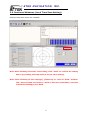
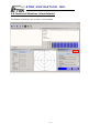
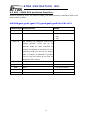
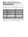
1
Marine GPS Locator
GM-88K
User’s Manual
Version A
Please read this manual before operating the unit
May 2007
© ETEK NAVIGATION, INC.
ETEK NAVIGATION, INC.
9F, No.105, Xicheng Rd., Banqiao City,
Taipei County 220, Taiwan (R.O.C.)
TEL: 886-2-26860199 FAX: 886-2-26879500
E-Mail: [email protected]
http://www.etek.com.tw
ETEK NAVIGATION, INC.
P R O F E S S I O N A L I N N AV I G AT I O N & C O M M U N I C AT I O N
Content
Package Content ................................................................... 3
Chapter 1 Overview .............................................................. 4
1.1 What is GPS? ............................................................. 4
1.2 System Requirements................................................ 6
Chapter 2 Installing GM-88K................................................. 7
2.1 Interfacing ................................................................ 7
Chapter 3 Installation & Operating Procedures .................... 8
3.1 Installing GPS Utility Analyzer................................... 8
3.2 Connecting Com Port ................................................. 9
3.3 Functional Windows (Interval Setting).................... 10
3.4 Functional Windows (Local Time Zone Setting) ....... 11
3.5 Functional Windows (SBAS Setting) ........................ 12
3.6 Functional Windows (Power Mode Setting) ............. 13
3.7 Functional Windows (Restart Setting)..................... 14
3.8 Functional Windows (View Default) ........................ 15
Chapter 4 Applications ........................................................ 16
Chapter 5 Specification ....................................................... 17
Chapter 6 Troubleshooting ................................................. 18
Case 1
Case 2
Chapter 7 Limited Warranty ............................................... 19
Chapter 8 Available NMEA Messages................................... 20
8.1 NMEA Protocol ............................................................ 20
8.2 GGA – GPS Fix Data ................................................. 21
8.3 GLL – Geographic Position – Latitude/Longitude..... 22
8.4 GSA – GNSS DOP and Active Satellites .................... 23
8.5 GSV – GNSS Satellites in View ................................. 24
8.6 RMC – Recommended Minimum Specific GNSS Data 25
8.7 VTG – Course over Ground and Ground Speed ......... 26
8.8 ZDA – Time & Date .................................................. 27
2
ETEK NAVIGATION, INC.
P R O F E S S I O N A L I N N AV I G AT I O N & C O M M U N I C AT I O N
Package Content
1.
One GM-88K w/15 meter cable
2.
User’s Manual
3.
CD-ROM(Software-GPS Utility Analyzer)
Please check if all of the contents listed are included and it not damage from shipping if any
of the items are missing or damage, please notify ETEK NAVIGATION, INC.
http://www.etek.com.tw
E-mail: [email protected]
3
ETEK NAVIGATION, INC.
P R O F E S S I O N A L I N N AV I G AT I O N & C O M M U N I C AT I O N
Chapter 1
Overview
GM-88K is an outstanding high sensitivity Marine GPS receiver. Its excellent
performance easily conquers the most difficult tasks. In addition, it provides various
functions to meet customers' needs. You will find the device an accurate, reliable and
useful aid to your positioning pursuits.
GM-88K is the latest GPS product innovation in combining GPS receiver technology
and mini-antenna in a Plug-Navigate-Location concept from ETEK NAVIGATION, INC.
GM-88K receives FREE broadcast signals from the Low Orbit Global Positioning
System (GPS), a satellite-based transmitter which emits ranging/satellite information/high
precision time signals that the GM-88K receiver can use to determine positions and time.
It also has high sensitivity for weak signal operation without compromising accuracy.
Undoubtedly, GM-88K is the best choice for you.
Before introducing you our new receiver, we would like to give you some basic
background knowledge about GPS, which should be helpful for you to better understand
your GM-88K.
1.1
What is GPS?
GPS (Global Positioning System) is a satellite-based global navigation system created
and operated by the United States Department of Defense (DOD). Originally intended
4
ETEK NAVIGATION, INC.
P R O F E S S I O N A L I N N AV I G AT I O N & C O M M U N I C AT I O N
solely to enhance military defense capabilities, GPS capabilities have expanded to provide
highly accurate position and timing information for many civilian applications.
An in-depth study of GPS is required to fully understand how it works, but simply
stated: Twenty four satellites in six orbital paths circle the earth twice each day at an
inclination angle of approximately 55 degrees to the equator. This constellation of satellites
continuously transmits coded positional and timing information at high frequencies in the
1500 Megahertz range. GPS receivers with antennas located in a position to clearly view
the satellites pick up these signals and use the coded information to calculate a position in
an earth coordinate system. GPS is the navigation system of choice for today and many
years to come. While GPS is clearly the most accurate worldwide all-weather navigation
system yet developed, it still can exhibit significant errors. GPS receivers determine
position by calculating the time it takes for the radio signals transmitted from each satellite
to reach earth. It’s that old "Distance = Rate x Time" equation. Radio waves travel at the
speed of light (Rate). Time is determined using an ingenious code matching technique
within the GPS receiver. With time determined, and the fact that the satellite’s position is
reported in each coded navigation message, by using a little trigonometry the receiver can
determine its location on earth.
Position accuracy depends on the receiver’s ability to accurately calculate the time it
takes for each satellite signal to travel to earth. This is where the problem lies. There are
primarily five sources of errors which can affect the receiver’s calculation. These errors
consist of (1) ionosphere and troposphere delays on the radio signal, (2) signal multi-path,
(3) receiver clock biases, (4) orbital errors, also known as ephemeris errors of the
satellite's exact location, and (5) the intentional degradation of the satellite signal by the
DOD. This intentional degradation of the signal is known as "Selective Availability (SA)" and
is intended to prevent adversaries from exploiting highly accurate GPS signals and using
them against the United States or its allies. However, on May 1, 2000, U.S. President Bill
Clinton ordered Selective Availability (SA) turned off at midnight (Coordinated Universal
Time). Now, civilian GPS users around the world will no longer experience the up to 100
meter (approximate 300 feet) random errors that SA added to keep GPS a more powerful
tool for the military. Today, GPS units are accurate to within 20 meters (approximately 60
feet); although in good conditions, units should display an error of less than 10 meters. The
combination of these errors in conjunction with poor satellite geometry can limit GPS
accuracy to 100 meters 95% of the time and up to 300 meters 5% of the time. Fortunately,
many of these errors can be reduced or eliminated through a technique known as
"Differential."
5
ETEK NAVIGATION, INC.
P R O F E S S I O N A L I N N AV I G AT I O N & C O M M U N I C AT I O N
1.2
System Requirements
System requirements for operating your new GM-88K GPS Locator are as follows:
PC running Windows OS or any OS that is compatible with GPS NMEA data format. PDA,
Palm-PC, Chart Plotter, Notebook or Micro-controller using UART as serial bus.
Power source using DC 12V from car or boat.
Un-obstructed view of the SKY for the satellites over the sky can be seen by the
device.
6
ETEK NAVIGATION, INC.
P R O F E S S I O N A L I N N AV I G AT I O N & C O M M U N I C AT I O N
Chapter 2
2.1
Installing GM-88K
Interfacing
GM-88K Open Cable
I/O PIN ASSUGNMENT
I/O PIN & CABLE
Wire
Function
Description
Green
Rx(RS-232)
To receive external command from PC(Rx)
Orange
Tx(RS-232)
Outputs NMEA0183 sentences(Tx)
Braid
Earth
Black
Power-
Red
Power+
To be connected to vehicleasis for EMI
suppression if necessary
Power ground
(Negative)
Power input 8 to 35 V DC (Positive)
7
ETEK NAVIGATION, INC.
P R O F E S S I O N A L I N N AV I G AT I O N & C O M M U N I C AT I O N
Chapter 3
Installation & Operating
Procedures
With a complete familiarity of your new GPS Locator after referring to Figure 1 &
Figure 2, you are now supposed to be ready to connect the unit to your computing device.
PLEASE MAKE SURE THAT THE POWER IS OFF BEFORE PROCEEDING.
3.1 Installing GPS Utility Analyzer
GM-88K is shipped with a CD that stores an application program GPS Utility
Analyzer. To install this program, please follow the steps stated in next pages.
GPS Utility V2.61 is the latest utility for configuring the GPS settings of ETEK GPS receivers.
You can find the utility in the CD and the password is in License.txt. Double click on the
Setup.exe and follow the installation procedures.
GPS Utility (Version 2.61), an application program for GM-88K, enables you to do
the configurations on the receiver. Below are instructions of how to work with this software,
with assumption that you have successfully installed GPS Utility
8
ETEK NAVIGATION, INC.
P R O F E S S I O N A L I N N AV I G AT I O N & C O M M U N I C AT I O N
3.2 Connecting Com Port
After selecting the Com Port, bard rate and Command Setting, click on “Connect” and you
will be able to do the configurations.
Select the Com Port
Select baud rate (default of 4800)
Select SV3310
9
ETEK NAVIGATION, INC.
P R O F E S S I O N A L I N N AV I G AT I O N & C O M M U N I C AT I O N
3.3 Functional Windows (Interval Setting)
After connecting with success, you can view the NMEA data from different functional
windows. The configurations can be done in the “User Setting” window. On top of the
“User Setting” window, there are several taps. Please select the taps for different settings.
User Setting Window, change GPS sentence output interval
Note: After finishing interval setting, click “Send” to confirm the setting before
proceeding next tap window for the other setting.
Note: After finishing all the setting(s), please tap to “Save to Flash” window.
Tick “Save to Flash” and click on “Send” if the user would like to save the
customized setting(s) into flash.
10
ETEK NAVIGATION, INC.
P R O F E S S I O N A L I N N AV I G AT I O N & C O M M U N I C AT I O N
3.4 Functional Windows (Local Time Zone Setting)
Different local time zones are available.
Note: After finishing local time zone setting, click “Send” to confirm the setting
before proceeding next tap window for the other setting.
Note: After finishing all the setting(s), please tap to “Save to Flash” window.
Tick “Save to Flash” and click on “Send” if the user would like to save the
customized setting(s) into flash.
11
ETEK NAVIGATION, INC.
P R O F E S S I O N A L I N N AV I G AT I O N & C O M M U N I C AT I O N
3.5 Functional Windows (SBAS Setting)
Enable/Disable the SBAS (WAAS).
Note: After selecting the wanted SBAS setting, click “Send” to confirm the setting
before proceeding next tap window for the other setting.
Note: After finishing all the setting(s), please tap to “Save to Flash” window.
Tick “Save to Flash” and click on “Send” if the user would like to save the
customized setting(s) into flash.
12
ETEK NAVIGATION, INC.
P R O F E S S I O N A L I N N AV I G AT I O N & C O M M U N I C AT I O N
3.6 Functional Windows (Power Mode Setting)
Select the power mode and “Continuous” is preferred. Please contact ETEK for more
information about the power mode.
Note: After selecting the wanted power mode setting, click “Send” to confirm the
setting before proceeding next tap window for the other setting.
Note: After finishing all the setting(s), please tap to “Save to Flash” window.
Tick “Save to Flash” and click on “Send” if the user would like to save the
customized setting(s) into flash.
13
ETEK NAVIGATION, INC.
P R O F E S S I O N A L I N N AV I G AT I O N & C O M M U N I C AT I O N
3.7 Functional Windows (Restart Setting)
User can restart the unit by using this utility.
Note: After selecting the wanted restart setting, click “Send” to confirm the
setting before proceeding next tap window for the other setting.
Note: After finishing all the setting(s), please tap to “Save to Flash” window.
Tick “Save to Flash” and click on “Send” if the user would like to save the
customized setting(s) into flash.
14
ETEK NAVIGATION, INC.
P R O F E S S I O N A L I N N AV I G AT I O N & C O M M U N I C AT I O N
3.8 Functional Windows (View Default)
The default of receiver can be seen in this window.
15
ETEK NAVIGATION, INC.
P R O F E S S I O N A L I N N AV I G AT I O N & C O M M U N I C AT I O N
Chapter 4
Applications
GM-88K can be used in meeting GPS navigational needs or Precise Time source, with
a range of applicable fields as follows:
Car Navigation.
Fleet Management.
Mileage Management.
Tracking devices/system.
Data logging for marine Navigation.
Mapping devices for PC & Pocket PC.
Marine Navigation or touring devices.
AVL and Location-Based service system.
16
ETEK NAVIGATION, INC.
P R O F E S S I O N A L I N N AV I G AT I O N & C O M M U N I C AT I O N
Chapter 5
Specifications
Specification
Parameter
Description
General
L1 frequency, C/A code(SPS),
32 Independent tracking channel
Sensitivity
-158dBm
Accuracy
Acquisition
Position
Without aid: 3.3m CEP
DGPS(RTCM): 2.6m
Velocity
0.1 Knot RMS steady state
Cold start
41 sec. (typical)
Warm start
35 sec. (typical)
Hot start
1 sec. (typical)
Reacquisition
Dynamics
100 ms typical (signal reacquisition)
Altitude
18000m max.
Velocity
500 m/sec.
Vibration
4G max.
Operation Temperature
-30° C to +80° C
Storage Temperature
-40° C to +85° C
Operating Humidity
0% to 95% RH, non condensing
Water Resistance
100% waterproof
Primary Power
8V ~ 35V DC
Power Consumption
34mA~44mA @ 12V DC
Protocol
NMEA-0183 v3.01 baud rate(adjustable)
4800/9600/19200/38400/115200, default 4800
Signal level
RS-232(standard)
NMEA Message
Default
RMC, GGA, GSV*5, VTG, GSA*5
Optional
GLL, ZDA
Update rate
1~5Hz (Default, 1Hz)
DGPS Capability
RTCM protocol
EMI filter
Rejects power line interference
SBAS
1 channel (support WAAS, EGNOS, MSAS)
Power cable
UL 2464/ 24AWG,15M
Enclosure
High impact, corrosion-proof polycarbonate resin
Connector
7 pin circular, hermetically sealed. Gold plated for
anti-corrosion
Dimensions
Weight
GPS Locator
80mm(D) × 71.3 mm(H)
Mounting Base
110mm(W) × 70mm(L) × 75.2mm(H)
150 grams (without cable)
17
ETEK NAVIGATION, INC.
P R O F E S S I O N A L I N N AV I G AT I O N & C O M M U N I C AT I O N
Chapter 6
Troubleshooting
Case 1
No output
Suggested Solution:
Check whether the Com Port is enabled and whether you are using correct power supply.
Case 2
No activity or the Map Software is not receiving any GPS data.
Suggested Solution:
In our FREE GPS program the software automatically searches for Com 1 or Com 2 data as
soon as the program is executed. Make sure that the VP-88 is connected to Com 1 or Com
2.
18
ETEK NAVIGATION, INC.
P R O F E S S I O N A L I N N AV I G AT I O N & C O M M U N I C AT I O N
Chapter 7
Limited Warranty
Thank you for your purchase of GPS product from ETEK Navigation, Inc.
ETEK Navigation, Inc. warrants this product to be free from defects in materials and
workmanship for one year from the date of purchase. The warranty for accessories is six
months. The stamp of distributor or a copy of the original sales receipt is required as the
proof of purchase for warranty repairs .ETEK Navigation, Inc. will, at its sole option, repair
or replace any components, which fail in normal use. Such repairs or replacement will be
made at no charge to the customer for parts or labor. The customer is, however,
responsible for any transportation costs.
This warranty does not cover failures due to abuse, misuse, accident or unauthorized
alteration of repairs. ETEK assumes no responsibility for special, incidental, punitive or
consequential damages, or loss of use.
PURCHASER DUTIES
The purchaser must return defective unit postpaid, with the proof of original purchase and
a return address to:
ETEK NAVIGATION, INC.
10F, No.105, Xicheng Rd., Banqiao City,
Taipei County 220, Taiwan (R.O.C.).
Tel: 886-2-26860199
Fax: 886-2-26866159
http://www.etek.com
Technical Support: [email protected]
19
ETEK NAVIGATION, INC.
P R O F E S S I O N A L I N N AV I G AT I O N & C O M M U N I C AT I O N
Chapter 8 Available NMEA Messages
8.1 NMEA Protocol
The NMEA protocol expresses the data in the format of ASCII. This is a standard format for
GPS applications.
8.1.1 Standard NMEA Messages
The module can output 7 standard NMEA messages, which are
NMEA Output Messages
NMEA Record
Description
GGA
Global Positioning System Fix Data.
GSA
GNSS DOP and Active Satellites
GSV
GNSS Satellites in View
RMC
Recommended Minimum Navigation Information
VTG
Course Over Ground and Ground Speed
GLL
Geographic Position – Latitude / Longitude
ZDA
Time & Date
Those messages are output at TX1 at the rate of 4800 bps (default setting). When more
than 4 messaged are chosen, a higher baud rate than 4800 bps is required.
The following will summarize the available NMEA messages. More information about the
NMEA messages refers to “NMEA 0183, Standard for Interfacing Marine Electronic Devices,
Version 3.01.
20
ETEK NAVIGATION, INC.
P R O F E S S I O N A L I N N AV I G AT I O N & C O M M U N I C AT I O N
8.2 GGA – GPS Fix Data
Position fix related data, such as position, time, number of satellites in use, etc.
$GPGGA,gga1,gga2,gga3,gga4,gga5,gga6,gga7,gga8,gga9,gga10,
gga11,gga12,gga13,gga14*hh<CR><LF>
Parameters Descriptions
gga1
Notes
UTC time as position is fixed
hhmmss.sss: hh – hour; mm –
minute; ss.sss – second
gga2
Latitude
ddmm.mmmmmm: dd – degree;
mm.mmmmmm – minute (0o ~
90o)
gga3
Latitude sector
N – North; S - South
gga4
Longitude
dddmm.mmmmmm: dd – degree;
mm.mmmmmm – minute (0o ~
180o)
gga5
Longitude sector
E – East; W - West
gga6
GPS quality indicator
0 – No fixed or invalid position
1 – SPS Position available
2 – Differential GPS (SPS)
gga7
Number of SVs used in position xx: 00 ~ 12
estimation
gga8
HDOP
xx.xx: 00.00 ~ 99.99
gga9
Altitude above mean sea level xx.xxx: 00.000 ~ 99.999
(geoid)
gga10
Unit for Altitude
M: meter
gga11
Geoidal separation
gga12
Unit for geoidal separation
M: meter
gga13
Age of differential corrections
unit : second; null when DGPS is
not used
gga14
hh
<CR><LF>
Reference station ID (DGPS)
xxxx: 0000 ~ 1023
Checksum
hex number (2 – character)
End of message
21
ETEK NAVIGATION, INC.
P R O F E S S I O N A L I N N AV I G AT I O N & C O M M U N I C AT I O N
8.3 GLL – Geographic Position – Latitude/Longitude
Navigation data and status.
$GPGLL,gll1,gll2,gll3,gll4,gll5,gll6,gll7*hh<CR><LF>
Parameters Descriptions
gll1
Latitude
Notes
ddmm.mmmmmm: dd – degree;
mm.mmmmmm – minute (0o ~ 90o)
gll2
Latitude sector
N – North; S – South
gll3
Longitude
dddmm.mmmmmm: dd – degree;
mm.mmmmmm – minute (0o ~ 180o)
gll4
Longitude sector
E – East; W – West
gll5
UTC time as position is fixed hhmmss.ss: hh – hour; mm – minute;
ss.ss – second
gll6
Status for position fix
A – Valid; V – Invalid
gll7
Navigation mode indicator
A – Autonomous mode (fix);
D – Differential mode (fix);
E – DR (fix);
N – not valid
hh
<CR><LF>
Checksum
hex number (2 – character)
End of message
22
ETEK NAVIGATION, INC.
P R O F E S S I O N A L I N N AV I G AT I O N & C O M M U N I C AT I O N
8.4 GSA – GNSS DOP and Active Satellites
Receiver operating mode, the values of DOPs, and PRN numbers for satellites used in the
GGA position solution.
$GPGSA,gsa1,gsa2,(gsa3*12),gsa4,gsa5,gsa6*hh<CR><LF>
Parameters Descriptions
Notes
gsa1
Selection Mode
gsa2
Mode for position fix
1 – fix not available;
2 – 2D;
3 – 3D;
gsa3*12
PRN numbers for satellites used in the xx
position
solution.
There will be
12
available fields for PRN numbers. If
number of satellites is less than 12, the
remaining fields will be left as empty
fields. If number of satellites is greater
than 12, only the values of the first 12
satellites will be output.
gsa4
PDOP
0 ~ 99.99 in meters
gsa5
HDOP
0 ~ 99.99 in meters
gsa6
VDOP
0 ~ 99.99 in meters
Checksum
hex number (2 – character)
hh
<CR><LF>
End of message
23
ETEK NAVIGATION, INC.
P R O F E S S I O N A L I N N AV I G AT I O N & C O M M U N I C AT I O N
8.5 GSV – GNSS Satellites in View
This message indicates the observable satellites’ information, such as PRN numbers,
elevation, azimuth, SNR, and number of satellites in view.
$GPGSV,gsv1,gsv2,gsv3,((gsv4,gsv5,gsv6,gsv7)*n)*hh<CR><LF
>
Parameters Descriptions
Notes
gsv1
Total number of messages
1~9
gsv2
Message number
1~9
gsv3
Total number of satellites in view
xx
gsv4
PRN number
xx
gsv5
Elevation (degrees)
90o maximum
gsv6
Azimuth (degrees)
0o ~ 360o
gsv7
SNR (C/N0)
0 ~ 99 dB-Hz, null when not
tracking
hh
<CR><LF>
Checksum
hex number (2 – character)
End of message
The message can carry at most four (gsv4,gsv5,gsv6,gsv7) sets of observable satellites.
For a less than four-set case, the message only transmits available sets and the rest of
them will not be output, i.e., the message doesn’t transmit empty fields.
24
ETEK NAVIGATION, INC.
P R O F E S S I O N A L I N N AV I G AT I O N & C O M M U N I C AT I O N
8.6 RMC – Recommended Minimum Specific GNSS Data
This message transmits the necessary navigation data, such as time, position, speed,
course, and so on.
$GPRMC,rmc1,rmc2,rmc3,rmc4,rmc5,rmc6,rmc7,rmc8,rmc9,rmc1
0,rmc11,rmc12*hh<CR><LF>
Parameters Descriptions
rmc1
Notes
UTC time as position is fixed
hhmmss.sss: hh – hour; mm –
minute; ss.sss – second
rmc2
Status of position fix
A – data valid, which includes the
scenarios of 2D, 3D, and DR.
V – navigation receiver warning
rmc3
Latitude
ddmm.mmmmmm: dd – degree;
mm.mmmmmm – minute (0o ~
90o)
rmc4
Latitude sector
N – North; S – South
rmc5
Longitude
dddmm.mmmmmm: ddd –
degree; mm.mmmmmm – minute
(0o ~ 180o)
rmc6
Longitude sector
E- East; W- West
rmc7
Speed over ground (SOG)
x.xxx knots
rmc8
Course over ground (COG)
Referenced to true north (xx.xx
degrees)
rmc9
UTC Date
ddmmyy: dd – day; mm – month;
yy – year
rmc10
Magnetic variation
Not supported
rmc11
Direction of magnetic variation
Not supported
rmc12
Navigation mode indicator
A – Autonomous mode (fix);
D – Differential mode (fix);
E – DR (fix);
N – not valid
hh
<CR><LF>
Checksum
hex number (2 – character)
End of message
25
ETEK NAVIGATION, INC.
P R O F E S S I O N A L I N N AV I G AT I O N & C O M M U N I C AT I O N
8.7 VTG – Course over Ground and Ground Speed
This message transmits the speed and course relative to ground.
$GPVTG,vtg1,vtg2,vtg3,vtg4,vtg5,vtg6,vtg7,vtg8,vtg9*hh<CR><L
F>
Parameters Descriptions
Notes
vtg1
Course over ground (degrees)
Referenced to true north (xx.xxo)
vtg2
Indicator of course reference
T – true north
vtg3
Course over ground (degrees)
Not Support
vtg4
Indicator of course reference
M – magnetic north
vtg5
Speed over ground
x.xxx knots
vtg6
Unit of speed
N – nautical miles per hour
vtg7
Speed over ground
x.xxx km/hr
vtg8
Unit of speed
K – kilometers per hour
vtg9
Navigation mode indicator
A – Autonomous mode (fix);
D – Differential mode (fix);
E – DR (fix);
N – not valid
hh
<CR><LF>
Checksum
hex number (2 – character)
End of message
26
ETEK NAVIGATION, INC.
P R O F E S S I O N A L I N N AV I G AT I O N & C O M M U N I C AT I O N
8.8 ZDA – Time & Date
This message transmits UTC time and date, and local time zone.
$GPZDA,zda1,zda2,zda3,zda4,zda5,zda6*hh<CR><LF>
Parameters Descriptions
zda1
Notes
UTC time
hhmmss.sss: hh – hour; mm –
minute; ss.sss – second
zda2
UTC day
01 ~ 31
zda3
UTC month
01 ~ 12
zda4
UTC year
xxxx (4 digits)
zda5
Local zone hours
00 to ± 13 hours
zda6
Local zone minutes
00 to ± 60 minutes
Checksum
hex number (2 – character)
hh
<CR><LF>
End of message
27