1
icgrld5
P3
MR PUP_ 1. TS\S
(LEN1MEN1G SE MON)
•
--
NUREAU W M NERAL RESOURCES,
GE0_,OGY AND SWF HM=6
-
•
RECORD 1984/5
NECON)
THE AUSTCO
DATA BASE SYSTEM:
•
USER MANUAL
•
by
•
ALAN L. HINDE
•
The information contained in this report has been obtained by the Bureau of Mineral Resources. Geology and Geophysics as
part of the policy of the Australian Government to assist in the exploration and development of mineral resources. It may not be
published in any form or used in a company prospectus or statement without the permission in writing of the Director.
RECORD 1984/5
S
THE AUSTCO
DATA BASE SYSTEM:
USER MANUAL
0
•
by
•
ALAN L. HINDE
•
•
CONTENTS
•
•
•
•
•
SUMMARY
INTRODUCTION^
2
FORMAT OF THE AUSTCO FILE^
3
USING THE AUSTCO DATA BASE SYSTEM ^
4
Sorting the data file ^
4
Conventions for naming sorted files^
5
Adding new data^
5
Checking added data^
5
Correcting data^
6
Extracting data for input to program LAMDA ^
6
Extracting wells from an irregular digitised area ^
7
Extracting wells from a rectangular area^
8
Automatic naming of basins and sub-basins^
8
Plotting annual totals of data^
9
Tabulating annual totals of data^
9
DESCRIPTION OF AUSTCO DATA BASE PROGRAMS^
9
Program SORT^(for sorting)^
9
Program ASCHK^(for checking AUSTCO)^
10
Program AS120^(for ensuring equal record lengths and correct well
name format, and converting feet to metres)^11
O^ Program ASLAM^(for preparing input to program LAMDA) ^11
Program SIMUL^(for digitising) ^
12
Program DIGEO^(for converting digitised data to latitudes
and longitudes) ^
•
12
Program ASBOU^(for extracting wells within a digitised area) ^13
Program ASWIN^(for extracting wells within a rectangular area) ^13
Program BPLOT^(for plotting digitised boundaries and well
locations)^
•
14
Program ASNAM^(for naming basin and sub-basin of wells within
a digitised area)^
15
Program ASPLT^(for plotting yearly totals of data in AUSTCO) ^15
Program ASTAB^(for tabulating yearly totals of data in AUSTCO) ^16
•
REFERENCES^
17
APPENDIX I^Abbreviations for sub-basins^
18
APPENDIX II^Abbreviations for companies ^
19
APPENDIX III Abbreviations for well classifications^ 26
•
•
1
SUMMARY
This manual describes the AUSTCO data base system, which consists
of a data file and associated software. The data file may be accessed
•
•^
•
•
•
•
•
directly with the text editor, or the software, written in FORTRAN, may
be used for various tasks associated with the data base. These include
a program to select the wells lying within a digitised map boundary; a
program to prepare files of data for input to the program LAMDA, which
is used to assess hypothetical undiscovered petroleum resources, and a
plotting program to produce graphs of data in AUSTCO.
2
INTRODUCTION
The AUSTCO data base system (Forman and others, 1984) consists
of a data file containing information about petroleum exploration and
development wells drilled in Australia, and a number of programs for
carrying out tasks associated with the data base. Information stored
in the file, which is called AUSTCO:915:9, includes well name and number,
well coordinates (latitude and longitude), State, whether onshore or
offshore, basin, sub—basin or infrabasin, company, classification (type
of well), total depth, date reached total depth, whether oil, gas, or
oil and gas were discovered, and identified resources of oil, condensate,
LPG, and sales gas. The text editor is used for adding new data,
correcting data, and searching for specific wells. A sort program, already
available on the HP computer, is used to sort the AUSTCO file.
A number of FORTRAN programs have been written to carry out
more involved tasks. There is a program to prepare input data for LAMDA,
which assesses hypothetical petroleum resources (Hinde, 1984). Another
program will select wells within an irregular, digitised map boundary
or within a rectangular area of known coordinates, while another program
provides graphical plots of yearly totals of oil and gas reserves discovered,
number of new—field wildcats drilled, and depths drilled for the area
selected.
The next chapter describes how AUSTCO is organised (ie its format).
Subsequent chapters describe how to use the data base system to achieve
the tasks mentioned above, and describe the use of the individual FORTRAN
programs.
3
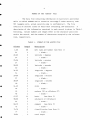
FORMAT OF THE 'AUSTCO' FILE
Tfte data file containing information on Australia's petroleum
wells is called AUSTCO and is stored on cartridge 9 under security code
915 (example only, actual security code is confidential). The file
consists of records (lines of data) each containing 120 characters. A
description of the information contained in each record is given in Table 1
following. Column numbers and length refer to the character positions
within the record, and the number of characters occupied by the relevant
item, respectively.
TABLE 1. FORMAT OF THE AUSTCO FILE
Columns^Length^Description
1=20^20^well name and number (see Note 1)
21^1^- blank
41^22-23^2^latitude
-
: degrees
24^1^- blank 25-26^2^latitude : minutes
27^1^- blank
II^28-29^2^latitude
-
: seconds
30^1^- blank 31-33^3^longitude : degrees
34^1^- blank
Ilk^35-36^2^longitude
-
: minutes
37^1^- blank 38-39^2^longitude : seconds
40^1^- blank
-
IP^41-43^3^state
44^1^- blank 45^1^onshore (N) or offshore (F)
46^1^- blank
•
-
47-57^11^basin^(see Note 2)
58-66^9^sub-basin or infrabasin
67^1^- blank 68-72^5^company^(see Note 3)
•
73^1^- blank 74-76^3^classification (see Note 4)
77^1^- blank 78-81^4^total depth
4
Columns^Length^Description
82^1^units for total depth (M-metres, F-feet)
83^1^- blank 84-89^6^date reached total depth
90^1^- blank 91^1^0- oil, G - gas, X - both
92^1^- blank -
6 3
93-99^7^volume of identified oil resources (10 m )
6 3
100-106^7^volume of identified condensate resources (10 m )
6 3
107-113^7^volume of identified LPG resources (10 m )
9 3
- 114-120^7^volume of identified sales gas resources (10 m )
Notes:
1.
fa enable correct sorting, an extra space is inserted between well
name and number when the number is a single digit (1-9).
2.
Abbreviations for sub-basins are given in Appendix I.
3.
Abbreviations for companies are given in Appendix II.
4.
Abbreviations for well classifications are given in Appendix III.
USING THE AUSTCO DATA BASE SYSTEM
This chapter describes how to use the data base system, assuming
that the user knows how to log-on and log-off, how to handle files, and
how to use the text editor on BMR's HP computer system. The data base
system is accessible under account ALAN.RESAS, with security code 915,
on cartridge 9. It consists of a data file, called AUSTCO, and twelve
programs for sorting, checking, correcting, extracting, and plotting data.
Sorting the data file
The sort program is restored with the command: RP,SORT:53:2 and
run with the command: RU,SORT. The program will prompt the user to enter:
the name of the file to be sorted (AUSTCO:915:9); the name of the new
sorted file (eg AUSTC1:915:9);^output file type, size, and record
length (4,24,120); scratch cartridge (60); type of sort (2); maximum
number of records (say 4000); trace (0); key type (C); key start and
length (eg 47,20). Key type, key start, and Length are entered for each
character field on which the file is to be sorted. When no more keys are
to be entered, press the RETURN button in response to the prompt for key
type.
^
5
Key type should always be C (for character) even on numeric
fields. Key start is the first column of the field and key length is the
number of columns within the field. For example, if the file is to be
sorted, firstly by basin, then by well name, the first key start and
^
length would be' 47,20 and the second would be 1,20. Table 1 has been set
•
out to facilitate the specifications of sort keys.
Conventions for naming sorted files
41^
A new file is created when AUSTCO is sorted. The following
conventions are suggested for naming the new files.
Key start
Name of file^Sorted on (in order of priority)
and length
i1^
AUSTCO^well name and number^
1,20
AUSTC1^basin and sub-basin or infrabasin^47,20
well name and number^
41^AUSTC2^basin
•
and sub-basin or infrabasin^47,20
TD date: year^
88,2
TD date: month^
86,2
TD date: day^
84,2
AUSTC3^TD date: year^
41^Adding
1,20
88,2
TD date: month^
86,2
TD date: day^
84,2
new data
Use the text editor to compile the new data into a new file
with the AUSTCO format already described. Add this file to AUSTCO after
•
checking and correcting. Then re-sort AUSTCO.
Checking added data
Program ASCHK has been written to check AUSTCO for possible
errors such as characters appearing in columns that should be blank, or
oil field sizes appearing when only gas is indicated, and vice versa.
Program ASCHK is restored with the command: RP,ASCHK and run with the
command: RU,ASCHK.
Program ASCHK may be used whenever additions or corrections are
made to AUSTCO. All the sorted versions of AUSTCO should be deleted and
•^
re-created whenever changes are made. Alternatively a sorted version of
AUSTCO (eg AUSTC1) may be altered and the other sorted files deleted and
re-created.
•
6
Correcting data
Use the text editor for most corrections.
Program AS120 may be used to bring each record to a length of
120 columns, bring well names to a common format, and convert well depths
from feet to metres. The format for well names is given in Note 1 of
Table 1.
To run AS120, use the commands: RP,AS120 and RU,AS120 and type
in the name of the input file (of AUSTCO format) and the name of the output
file (a new file that will take the place of the input file). After
running the program, the input file may be deleted and the output file
renamed.
Extracting data for input to program LAMDA
Program LAMDA produces assessments of hypothetical undiscovered
oil and gas reserves in a given basin, sub-basin, or area. The program
has been documented elsewhere (Hinde, 1984). Input to LAMDA is a data
file, called DATL, containing: estimates of identified oil or gas
resources within new-field discoveries, listed in order of discovery;
corresponding new-field wildcat well names and numbers and sequence numbers;
and the total number of new-field wildcat wells drilled in the area.
Data file DATL is prepared automatically from data file AUSTC2
by program ASLAM. To restore and run ASLAM, use the commands: RP,ASLAM
and RU,ASLAM. The program will prompt the user to enter: the name of
the file (AUSTC2 by convention), the basin name, the sub-basin, and whether
the resources are oil or gas.
At this stage LAMDA may be run to produce a summary of the data,
a straight line fit to the log-field size versus new-field wildcat well
number plot, and graphs of cumulative resources and cumulative number of
new-field discoveries. To produce an assessment DATL must first be
edited to include the future number of new-field wildcat wells to be drilled,
the number of iterations, and a triangular distribution for the success
rate. Program LAMDA is then run for a second time.
•
•^
7
Extracting wells from an irregular digitised area
Well data may be extracted from an irregular area if the area
•^
is digitised. Three programs are required for this: program SIMUL
transfers numbers from the coordinate digitiser (located in the Drawing
Office on the second floor of the BMR building) to a computer file;
program DIGEO converts this file into a file of latitude-longitude pairs;
and program ASBOU uses the latter file to extract the required well data
•^
from AUSTCO (or one of the sorted files) and store it in a new file. The
steps in this procedure are as follows.
•^
Step 1. Secure a map of the area to the digitising table. Turn on
the digitiser and set it in point mode. Log-on to the adjacent terminal
and run program SIMUL. (Instructions for using the digitiser and
running SIMUL can be found near the terminal, or someone in the Drawing
Office may be asked for assistance. Program SIMUL simulates program
GRADI, which was used when digitising with the old digitiser.
•^Instructions
for program GRADI can be found in 'Documentation for program
DICED', which is kept in the desk next to the digitiser.) Enter the
•^
output file name and any other information requested by the program.
Now enter, at the terminal, the title or description of the work, the
latitudes and longitudes of four control points (such as the corners
•^
of the map boundary), the map scale, and the map projection. Each
line should begin with the character -C to indicate that they are
comments. Then digitise the four control points.
The area to be studied may now be digitised. Digitise in a clockwise
•^
direction. Take care that no two points are very close (say <.1 mm)
and that the boundary does not cross itself anywhere. The last
digitised point need not be the same as the first, because program
•^
ASBOU automatically joins the first and last points.
When the digitising is completed, press the '*' button on the cursor.
Finally, switch off the digitiser and log-off.
•
0
8
Step 2. Log—on (at any terminal), then restore, and run program DIGEO
with the commands: RP,DIGEO and RU,DIGEO. This produces a new file
of latitude—longitude pairs. The program will call for the following
information: the name of the file produced by program SIMUL in step 1;
the output option (use the value 2 — disk output only); the name of
the output file, its security code, and cartridge number (a new file
to contain the latitude—longitude pairs); the map projection; the
two standard parallels (for Lambert conformal conic projection); the
scale of the map, and the latitude and longitude of each control point.
Step 3. Restore and run program ASBOU with the commands: RP,ASBOU
and RU,ASBOU. The program will call for: the input file name (ie the
file produced by program DIGEO in Step 2) and the output file name (a
new file). This final file will contain the data for the wells
extracted, in the format of the AUSTCO file.
Extracting wells from a rectangular area
Program ASWIN may be used to extract well data from within a
rectangular area whose sides are aligned along the parallels and
meridians.
To run ASWIN use the commands: RP,ASWIN and RU,ASWIN and type
in the name of the input file (of AUSTCO format), the name of the output
file, the minimum and maximum longitude (decimal degrees), and the
minimum and maximum latitude (positive decimal degrees, southern latitude
is assumed).
Automatic naming of basins and sub—basins
,Program ASNAM automatically enters the name of the basin and
sub—basin (or infrabasin) for wells within a digitised boundary. To run
ASNAM use the commands, RP,ASNAM and RU,ASNAM, and type in the name of
the input file (of AUSTCO format), the name of the output file (the new
file that will replace the input file), the new basin name, the new
sub—basin or infrabasin name, and the name of the file containing
coordinates of the digitised boundary (a file produced by program DIGEO).
After running the program, the input file may be deleted and the output
file renamed.
^
•
9
•^Plotting annual totals of data
ASPLT may be used to plot the annual totals of oil or gas resources
identified in new—field discoveries, annual totals of new—field wildcat
•^wells drilled, or annual kilometres drilled. The data are plotted for
a specified basin or sub—basin, or if these are not specified, they are
plotted for the area represented by the entire file. Direct foreign investment,
portfolio foreign investment, or total foreign investment, adjusted by
•^the consumer price index to give approximately constant prices, may also
be plotted. Any two of these data may be plotted on the same graph.
The program is restored and run with the commands, RP,ASPLT and
•
RU,ASPLT. It will ask the user to enter the name of the data file, the
required basin and sub—basin, whether onshore or offshore wells, or both,
are to be used, and the type of data to be plotted (one at a time). A
•
coloured pen plot is produced on the zeta (drum) plotter.
Tabulating annual totals of data
Program ASTAB is used to tabulate annual totals of number of
•^number of new—field discoveries containing gas, success ratios for oil
new—field wildcat wells, number of new—field discoveries containing oil,
and gas, the success ratio for new—field discoveries, km drilled, and
total oil and gas resources identified within new—field discoveries. To
•^where u specifies where the output is to be sent. If u ^1 or u is not
restore and run the program use the commands: RP,ASTAB and RU,ASTAB,u,
specified the output is sent to the screen, if u = 16 the output is sent
to the printer. The program will ask for the name of the input data file
•
(of AUSTCO format).
DESCRIPTION OF AUSTCO DATA BASE PROGRAMS
•^data base system.
This chapter summarises the use of each program in the AUSTCO
Program SORT
Purpose: to sort a data file on specified data fields (keys).
Usage: RP,SORT:53:2
RU,SORT
•
I0
Input files required: the data file to be sorted.
Input required from the terminal (in response to prompts): ^
•
the name of the file to be sorted;
the name of the (new) file to contain the output;
•
the type of the output file, its size and record length
(4,24,120 for an AUSTCO file);
•
the scratch cartridge number (60);
•
the type of sort (2 - new file);
•
the maximum number of records (say 4000)
•
whether a trace of the program is required (0 - no, 1 - yes);
•
the type of data field on which the file is to be sorted
(use C for character type);
•
the starting position of the data field on which the file is
to be sorted, and the number of characters in the field
(eg 47,20).
The last three lines are repeated for each key. The keys are
entered in decreasing priority. A blank line is entered to signify the
-
end of data and start of program.
Output files produced: the sorted file.
Comments: if this program is terminated before completion, four scratch
files will be left on the system. They should be deleted. They are:
.SRT.1, •SRT.2, .SRT.A, .SRT.B. and are stored on cartridge 60 under
security code O.
Program ASCHK
Purpose: To check the AUSTCO file for obvious errors.
Usage: FT,ASCHK„-B^or^RP,ASCHK
LO
RU,ASCHK
Input files required: AUSTCO or a file with the same format.
Input required from the terminal (in response to prompts):
•
name of the data file.
Output files produced: none
Output at the terminal: Any record, in which an error is detected, is
displayed on the terminal screen. Up-arrow symbols ('-') are displayed
beneath the record to show where the suspected error or errors are.
•
•
ii
•
Program AS120
Purpose: To ensure that all records in the AUSTCO file have 120 characters.
To ensure that all well names and numbers conform to the convention in
Note 1 of Table 1. To convert well depths from feet to metres.
•^Usage: FT,AS120„—B^or^RP,AS120
LO
RU,AS120
•
Input files required: AUSTCO or a file with the same format.
Input required from the terminal. (in response to prompts):
the name of the input data file (of AUSTCO format);
the name of the new file (to replace the input file).
•
Output files produced: A new file in the same format as AUSTCO, to
replace the old file.
Comments: After running AS120 the old file can be replaced with the new
•
^file by deleting the old file with the command: PU,old file
then renaming the new file to the old file with the command:
RN,newfile,old file
Program ASLAM
Purpose: To select from the AUSTCO data file all oil or gas fields for
a specified basin/sub—basin and to make from these the file, DATL, ready
for use by program LAMDA.
41^Usage: FT,ASLAM,,.-Bt ^or^RP,ASLAM
LO
RU,ASLAM
Input file required: AUSTC2 or AUSTC3
Input required from the terminal (in response to prompts):
the name of the input file (if not AUSTC2);
basin name;
sub—basin or infrabasin;
whether oil or gas.
Output files produced: DATL (the input file to program LAMDA) containing
sufficient data to run LAMDA without a future assessment. See the record
on program LAMDA (Hinde, 1984) for further details about the format of
this file. DATL must already be present on the computer before running
AS LAM.
Comments: To prepare DATL for all oil or gas fields in Australia, leave
basin and sub—basin blank and use AUSTC3 for the input file.
•
12
Program SIMUL
Purpose: To create a file of digitised x,y coordinates while operating
the digitiser (located in the Drawing Office on the second floor).
Usage: Running program SIMUL and using the digitiser is described in
documentation kept near the digitiser.
Input files required: none
Input required from the terminal before digitising:
data requested by the program with prompts;
any comments to be inserted in the file (denoted by the characters,
-C, at the beginning of the line).
Output files produced: A file containing the digitised x,y coordinate
pairs. There should be 4 pairs peT line.
Comments: This program was written by, and is maintained by, the Drawing
Office staff. It is subject to alteration by them.
Program DIGEO
Purpose: To convert x,y coordinate pairs, (in mm) obtained by digitising
a map, into latitude-longitude pairs.
Usage: RU,LOADR^or^RP,DIGEO
REL,DIGEOR
END
RU,DIGEO
For greater details on running DIGEO, see the documentation kept in the
desk next to the digitiser.
Input files required: A file containing digitised x,y coordinate pairs,
4 pairs per line. This file is produced during the digitising process
using program SIMUL
Input required from the terminal (in response to prompts):
:
input data file name;
where the output is to be sent (a new file and/or the printer);
the output file name, its security code and cartridge;
the projection of the digitised map;
the standard parallels (if the map project is the Lambert
conformal conic);
the scale of the digitised map;
the latitudes and longitudes of the four control points (these
are to be given as signed decimal numbers, eg latitude
°
26 30 S is to be typed -25.5).
^
13
•
^Output file produced: A file containing the latitudes and longitudes of
the digitised map.
Program ASBOU
Purpose: To extract from the AUSTCO data file those new-field wildcats
lying within a map boundary, the boundary having been digitised with the
digitiser located on the second floor, and place them in a new file.
•^LO^•
Usage: FT,ASBOUN„-B^Or^RP,ASBOU
RU,ASBOU
Input files required:
containing the latitudes and longitudes of the digitised
•^a file
boundary in the format produced by program DIGEO;
AUSTCO or a file with the same format.
Input required from the terminal (in response to prompts):
•^the name of the input data file;
the name of the (new) output file;
the name of the file containing the digitised boundary.
Output files produced: A file containing the new-field wildcats selected
from AUSTCO that lie within the digitised boundary. The format of this
file is exactly the same as the AUSTCO file.
Comments: Program BPLOT can be used to check the results of ASBOU by
•
plotting the boundary and the positions of the selected wells.
Program ASWIN
•^lying within a rectangular boundary, ie a four-sided window aligned along
Purpose: To extract from the AUSTCO data file those new-field wildcats
parallels of latitude and meridians of longitude.
Usage: FT,ASWIN„-14^or^RP,ASWIN
•^LO
RU,ASWIN
Input files required: AUSTCO or a file with the same format.
Input required from the terminal (in response to prompts):
•^
the name of the input data file;
the name of the (new) output file;
the minimum longitude (in decimal degrees);
14
the maximum longitude (in decimal degrees);
theminimum latitude (in positive decimal degrees south);
the maximum latitude (in positive decimal degrees south).
Output files produced: A file containing the data for the new—field wildcats
taken from AUSTCO that lie within the rectangle. The format of this file
is exactly the same as the AUSTCO file.
Program BPLOT
Purpose: To produce a plot, on the HP printer/plotter, of a digitised
boundary and (optionally) of well locations. A standard map projection
is not produced, rather, the latitudes and longitudes are plotted without
transformation. The program is intended to be used as a visual check of
the digitised boundary and well locations.
Usage: FT,BBPLOT„—B^or^RP,BPLOT
LO
RU,BP LOT
Input files required:
a file containing the latitudes and longitudes of the digitised
boundary in the format produced by DIGEO;
a file, in AUSTCO format, containing the wells to be plotted
(optional).
Input required from the terminal (in response to prompts):
a title (40 characters);
XO, YO, Xl, Y2 (format 4F10.0) where
XO = longitude of the lower left corner of plot,
YO = latitude of the lower left corner of plot,
X1 = longitude of the lower right corner of plot,
X2 = latitude of the upper left corner of plot,
these are in signed decimal degrees;
the name of the file containing the digitised boundary;
the name of the file containing the wells to be plotted (if this
is not required, type RETURN only).
Output produced: One plot, on the HP printer/plotter, of the digitised
boundary. The title is plotted at the top. If well locations are plotted
they are represented with '4-
1
symbols.
•
15
•^Program ASNAM
Purpose: To name, in the AUSTCO file, the basin and sub-basin (or
infrabasin) of all wells that lie within a digitised area.
Usage: FT,ASNAME„-B^or^RP,ASNAM
LO
RU,ASNAM
•^.^AUSTCO or a file with the same format;
Input files required:
•
a file containing the latitudes and longitudes of the digitised
boundary in the format produced by DIGEO.
Input required from the terminal (in response to prompts):
the name of the input data file (of AUSTCO format);
the name of the new file (to replace the input file);
•
the new basin name;
the new sub-basin name;
•
the name of the file containing the digitised boundary.
Output files produced: A new file, in the same format as AUSTCO, to replace
•^Comments: After running ASNAM the old file can be replaced with the new
the old file.
file by deleting the old file with the command:
PU,old file
then renaming the new file to the old file with the command:
•^
RN,new file,old file.
Program ASPLT
Purpose: To plot, for a specified basin, yearly totals of AUSTCO data
•
and foreign investment against year (from 1960 to 1983). The data that
may be 'plotted are: oil resources, gas resources, number of new-field
wildcats, kilometres of new-field wildcats drilled, direct foreign
investment portfolio foreign investment, and total foreign investment. The
•
last three are adjusted by the consumer price index to give approximately
constant 75/76 prices. Any two of these series may be plotted within one graph
.
grame. Further series will be plotted in new graph frames, two per frame.
Data is plotted for new-field wildcats only.
Usage: FT,ASPLT„-B ^Or^RP,ASPLT
LO
•
RU,ASPLT
16
Input files required: AUSTCO or a file with the same format (how it is
sorted is irrelevant).
Input required from the terminal (in response to prompts):
the name of the input data file;
the required basin;
the required sub—basin or infrabasin;
whether only onshore (N), only offshore (F), or all
new—field wildcats are to be considered;
.^the data series to be plotted.
The last line may be repeated idenfinitely. A zero stops the program.
Output produced: A plot on the zeta (drum) plotter.
Comments: The range of years over which the data is plotted (1960 to 1983)
may be altered by altering the data statement labelled 1000 in the program.
The range is limited to a maximum span of 25 years, unless the DIMENSION
statement is altered.
Program ASTAB
Purpose: To tabulate for a specified basin, yearly totals of AUSTCO data.
The yearly data tabulated are: number of new—field wildcats, number of
oil fields, number of gas fields, success ratio for oil fields, gas fields,
and overall success ratio, kn of new—field wildcats drilled, total oil and
gas resources. Data is tabulated for new—field wildcats only.
Usage: FT,ASTAB„—B^or^RP,ASTAB
LO
RU,ASTAB,U^where U = the output device
Input files required: AUSTCO or a file with the same format (how it is
sorted is irrelevant).
Input required from the terminal (in response to prompts):
the name of the input data file.
Output produced: a table of the yearly data.
Comments: See comments for ASPLT.
17
REFERENCES
HINDE, AL., 1984 — LAMDA: A computer program for estimating hypothetical
petroleum resources using the 'creaming method'. Bureau of
Mineral Resources, Australia, Record 1984/4.
FORMAN, D.J., HINDE, A.L., and TOTTERDELL, J., 1984 — Data file AUSTCO:
wells drilled for petroleum in Australia (to January 1984).
Bureau of Mineral Resources, Australia, Report 256. BMR
Microform MF202.
•
•
•
18
APPENDIX I - ABBREVIATIONS FOR SUB-BASINS
ASHMORE^Ashmore Block (Bonaparte Basin)
BARBWIRE^Barbwire Terrace (Canning Basin)
BARROW^Barrow and Dampier Sub-basins (Carnarvon Basin)
BEAGLE^Beagle Sub-basin (Carnarvon Basin)
BEDOUT^Bedout Sub-Basin (Canning Basin)
BROOME^Broome Arch (Canning Basin)
CENTRAL^North of 26 degrees south (Bowen Basin)
CENTRAL^Central Deep (Gippsland Basin)
DARWIN^Darwin Shelf (Bonaparte Basin)
EXMOUTH^Exmouth Plateau (Carnarvon Basin)
FITZROY^Fitzroy Trough (Canning Basin)
JURGURRA^Jurgurra Terrace (Canning Basin)
KIDSON^Kidson Sub-basin (Canning Basin)
KIMBERLEY^Kimberley Shelf (Bonaparte Basin)
LENNARD S^Lennard Shelf (Canning Basin)
LONDON^Londonderry High (Bonaparte Basin)
MALITA^Malita Graben (Bonaparte Basin)
MARGARET^Margaret Terrace (Canning Basin)
PEEDA^Peedamullah Shelf (Carnarvon Basin)
PETREL^Petrel Sub-basin (Bonaparte Basin)
PORT CA^Port Campbell Embayment (Otway Basin)
RANKIN PL^Rankin Platform (Carnarvon Basin)
ROWLEY^Rowley Sub-basin (Canning Basin)
SAHUL^Sahul Platform (Bonaparte Basin)
SOUTHERN^South of 26 degrees south (Bowen Basin and overlying
Surat Basin)
VULCAN^Vulcan Sub-basin (Bonaparte Basin)
WALLAL^Wallal Embayment (Canning Basin)
WILLARA^Willara Sub-basin (Canning Basin)
19
APPENDIX II - ABBREVIATIONS FOR COMPANIES
ABOC^American Oil Company
ABOIL^Abrolhos Oil N.L., Abrolhos Oil & Investments Ltd
ACS^Australia-Cities Service Ltd
AEQ^Ampol Exploration (Queensland) Pty Ltd
AIS^Australian Iron and Steel Ltd
AMALG^Amalgamated Petroleum N.L., Amalgamated Petroleum
Exploration Pty Ltd
AMAX^Amax Petroleum (Australia) Inc., Amax Petroleum
AMOCO^Amoco Australia Exploration Company, Amoco Australia Pty Ltd
AMRDA^Amerada Petroleum Corporation of Australia Ltd
AOC^Australian Oil Corporation
AOD^Alliance Oil Development Australia N.L. (formerly Oil
Development N.L. and Alliance Petroleum Australia N.L.)
AOE^Australian Oil EXploration Ltd
AOG^Australian Oil and Gas Corporation Ltd
APEX^Apex Oil N.L.
APM^Australian Paper Manufacturers Development Pty Ltd
AQUIT^Australian Aquitaine Petroleum Pty Ltd
ARCO^Arco Australia Ltd
ARGON^Argonaut International Corporation
ARO^Australian Roma Oil Ltd
ASBTN^Ashburton Oil N.L.
ASEAS^American Overseas Petroleum Ltd
ASSOC^AAR Ltd, Associated Australian Resources N.L.,
Associated Australian Oilfields N.L.,
Associated Freney Oil Fields N.L.,
The Papuan Apinaipi Petroleum Company,
Interstate Oil Ltd,
Associated Continental Petroleum N.L.,
H.C. Sleigh Exploration Ltd
BALML^Balmoral Resources N.L.
BAO^British Australasian Oil Syndicate
BBC^Beaudesert Boring Company
BEA^Beaver Exploration Australia N.L.
BEACH^Beach Petroleum N.L.
BLACR^Blacker, Brady and Turner Syndicate
BLFRD^Belford Dome Ltd
20
BOC^B.O.C. of Australia Ltd, Bocal Pty Ltd
BOCPL^Barkley Oil Company Pty Ltd
BOP^Boona Oil Prospecting Company Ltd
BOWVL^Bow Valley Industries Ltd
BP^BP Petroleum Development Australia Pty Ltd
BRDGE^Bridge Oil Ltd, Bridge Oil N.L.
BRUNS^Brunswick Oil N.L., Oberon Oil Pty Ltd
BSH^Bishops
CABOT^Cabot Corporation
CAPE^Cape Range Oil N.L.
CCOL^.Central Coast Oil Ltd
CENTR.^Centralia Oil Pty Ltd
CITCO^Citco Australian Petroleum, Citco Australia Petroleum Ltd
CLINT^Clintons
CNW^Canada Northwest Australia Oil N.L.
COHO^Coho Exploration Pty Ltd
COMC^Clarence Oil and Minerals Company N.L.
COMSV^Comserv (No 779) Pty Ltd
CONCO^Conoco Australia Ltd (Continental Oil Company of
Australia Ltd)
CONDA^Condamine Oil Ltd
CNRDA^Conorada Petroleum Corporation
CPS^Coopers Creek Mining and Exploration N.L.
CRBO^Clarence River Basin Oil Exploration Company
CROL^Clarence River Oil N.L.
CRPC^Clarence River Prospecting Company Ltd
CRUSA^Crusader Oil N.L.
DAMSN^Damson Oil (Australia) Ltd
DEFE^Dome Frome
DELHI^Delhi Petroleum Pty Ltd, Delhi International Oil Corporation,
Delhi Australian Petroleum Ltd
DELTA^Delta Oil N.L.
DIAMD^Diamond Shamrock Oil Company (Australia) Pty Ltd
DOME^Dome Oil and Minerals Syndicate N.L.
.
DUBBO^Dubbo Oil Syndicate
EAGLE^Eagle Corporation Ltd
ENDEV^Endeavour Oil Company Ltd
ENRSC^Energy Resources Inc
ENTPO^Enterprise Oil Exploration Pty Ltd
21
ESPET^Eastern Petroleum Australia Ltd
ESSO^Esso Exploration and Production Australia Inc
EXOIL^Exoil Oil Company Pty Ltd, Exoil (N.T.) Pty Ltd,
Exoil (NSW) Pty Ltd
FBH^Frame Broken Hill Company Pty Ltd
FLIND^Flinders Petroleum N.L.
FMOUT^Farmout Drillers N.L.
•
FPC^French Petroleum Company (Australia) Pty Ltd,
French Petroleum Corporation
GASDR^Gas Drillers Ltd
GASFU^Gas and Fuel Exploration N.L.
•
GCS^Golden Chance Syndicate
GECAU^General Exploration Company of Australia Pty Ltd
GENOA^Genoa Oil N.L.
GEOIL^Geoil Ltd
•
GETTY^Getty Oil Development Company.Ltd
GEWEK^Gewerkschaft Elwerath
GFOC^Geelong Flow Oil Company
GOLDN^Golden West Hydrocarbons.
•
GULF^Australian Gulf Oil Company
HALDY^Halliday Enterprises Pty Ltd
HARTG^Hartogen Energy Ltd, Hartogen Exploration Pty Ltd
HBK^Henry B. Kelsey
•
HGHS^Hughes and Hughes Oil and Gas
HBSDE^Harbourside Oil N.L.
HDBAY^Hudbay Oil (Australia) Ltd
HEMAT^Hematite Petroleum Pty Ltd
•
HNL^R. Henzell
HNT^Hodinottes
HOME^Home Oil Australia Ltd
ROUST^Houston Oil and Minerals Australia Inc
HUMBR^Humber Barrier Reef Oils Pty Ltd
HUNT^Hunt Oil Company
IEDC^International Energy Development Corporation of Australia
Pty Ltd
•
INTOL^International Oils Exploration N.L.
IPP^Isis Petroleum Prospecting Syndicate
IPS^International Petroleum Services Pty Ltd
ISTOL^Interstate Oil Ltd
•
22
JIMBL^Jimbilly Pty Ltd
JOHEN^John Henry Resources Pty Ltd
LAKES^Lakes Oil Ltd
LETON^Leighton Mining
LNNRD^Lennard Oil N.L.
LOA^Landor Oilfields (Australia) Ltd
LOL^Longreach Oil Ltd, Longreach Oil Wells Ltd
LSD^Lucky Strike Drilling Company
LSG^LSG'Australia Inc
MAGLN^Magellan Petroleum Corporation, Magellan Petroleum
(Australia) Ltd, Magellan Petroleum (NT) Pty Ltd
MALTA^Malta Oil Company
MASKL^W.J. Maskell
MAYMN^Mayfair Minerals Inc
MBOS^Murray Basin Oil Syndicate
ME0^Mid-Eastern Oil N.L., Mid-Eastern Oil Company Ltd
MERID^Meridian Oil N.L.
MESA^Mesa Australia Ltd
MGNET^Magnet Metals N.L.
MINEX^Minex Inc
MOAGE^Moage Ltd
MOBIL^Mobil Oil Australia Ltd
MOL^Murilla Oil Ltd
MONAR^Monarch Petroleum N.L.
MOONI^Moonie Oil Company Ltd
MOP^Mackay Oil Prospecting Syndicate
MOW^Mineral Oils and Water Pty Ltd
MPY^Melrose Petroleum Prospecting Company
MRMBA^Murumba Oil N.L.
MRSYV^Mersey Valley Oil Company
MRTHN^Marathon Petroleum Australia Ltd
MWE^Mid-Wood Exploration pty Ltd
NAI^North American International Inc
NAO^Nortex Australian Oils Ltd
NBH^North Broken Hill Holdings Ltd
NGOCO^Natural Gas and Oil Corporation Ltd
NSTAR^North Star Oil Corporation
NSWOG^NSW Oil and Gas Company N.L., New South Wales Oil
and Gas Company Ltd
NUDEC^Nudec Petroleum Exploration Company
•
23
NWOIL^North West Oil and Minerals Company N.L.
OCA^Oil Company of Australia N.L.
OCCID^Australian Occidental Petroleum Inc,
Australian Occidental Petroleum Company
OCENA^Oceania Petroleum Pty Ltd
OCENV^Ocean Ventures Pty Ltd
OFFSH^Offshore Oil N.L.
OILG^Oil and Gas Investigation Ltd
•^OILSR^Oil Search Ltd
OILMN^Oilmin N.L.
00C^Orion Oil Company
OPL^Oil Prospectors Ltd
OTTER^Otter Exploration N.L.
OUTBK^Outback Oil Company N.L.
PACIF^Pacific Basin Exploration Pty Ltd
PADIS^Point Addis Oil Wells
PAP^The Papuan Apinaipi Petroleum Company Ltd
PENOL^Peninsula Oil Syndicate
PETEN^Petrofina
PEXA^Pexa Oil N.L.
Phillips Australian Oil Company, Phillips Petroleum Company
•^PHLPS^
PHOEN^Phoenix Oil and Gas N.L.
PLNET^Planet Exploration Company Pty Ltd
PNCON^Pancontinental Petroleum Pty Ltd
Pacific Petroleum N.L.
•^PNPAC^Pan
POP^Providence Oil Pty Ltd
PROJT^Project Oil Exploration Ltd
PSUIT^Pursuit Oil N.L.
QAO^Queensland American Oil Company
QCO^Queensland Coastal Oil Concessions (North)
QOC^Queensland Oil Corporation Ltd
QOD^Queensland Oil Development Company Ltd
QRO^Queensland Roma Oil Ltd
RAL^Roma Alicker Ltd
RBO^Roma Blocks Oil Company N.L.
RDL^Roma Dome Ltd
RJC^Robson and Jarvis and Co
ROC^Roma Oil Corporation
SAOG^South Australian Oil and Gas Corporation Pty Ltd
SAOW^South Australian Oil Wells Company
24
SDO^Salt Domes Oil Syndicate
SEOS^South East Oil Company
SGP^Standard Gas Pty Ltd
SHEC^Signal Hill Oil Exploration Company
SHELL^Shell Development (Australia) Pty Ltd
SHRLN^Shoreline Exploration Company
SLFAR^Silfar Pty Ltd, Silfar Oil and Gas Search Company Pty Ltd
SMART^L.H. Smart Oil Exploration Company Pty Ltd
SNTOS^Santos Ltd
SPP^South Pacific Pty Ltd
SQD^Shell (Queensland) Development Company Ltd
STRAT^Strata Oil N.L.
STREV^John Strevens (Terrigal)
STRLG^Stirling Petroleum N.L.
SUECP^Southern Union Energy Pty Ltd
SUN^Australian Sun Oil Company Ltd
SUNCA^Sun Oil Company of California
SYDOL^Sydney Oil Company Ltd
TEP^Target Exploration Pty Ltd, Target Petroleum N.L.
TEXAM^Texam Oil Corporation
TILE?^Tilley
TIMOR^Timor Oil Ltd
TNNCO^Tenneco Australia Inc
TOTAL^Total Exploration Australia Pty Ltd
TRANS^Transoil N.L.
TYLER^E.E. Tyler
ULTRA^Ultramar Australia Ltd
UNION^Union Oil Development Corporation (sometimes in
association with Kern County Land Company and
Australian Oil and Gas Corp Ltd)
UPR^United Petroleum Reserves N.L.
UTEX^Union Texas Petroleum Corporation
VALVE^Valve Oil Wells
VMGAS^Vamgas N.L., Vamgas Ltd
WAPET^West Australian Petroleum Pty Ltd
WCW^W.C. and H.J. Walz
WESTN^Western Resources Ltd
WESTR^Westralian Oil Ltd
WEVER^Weaver Oil and Gas Corporation Australia
•
25
WMC^Western Mining Corporation Ltd, Wesminco Oil Pty Ltd
WOC^Westland Oil Company Ltd
WOODS^Woodside Oil N.L., Woodside (Lakes Entrance) Oil Company N.L.
WPA^Woods Petroleum of Australia Ltd
WPD^Woodside Petroleum Ltd, Woodside Petroleum Development Pty Ltd
WPL^Winneills Pty Ltd
WPO^Wellington Point Oil Wells Ltd
XL^XL Petroleum Pty Ltd, XL Petroleum (NSW) Pty Ltd
^
•
YERBL^Yerrinbool Oil Prospecting Syndicate
ZANEX^Zanex Ltd
ZINC^Zinc Corporation Ltd
•
•
26
APPENDIX III — ABBREVIATIONS FOR WELL CLASSIFICATIONS
NFW^new—field wildcat
EXT^extension
SPT^shallow pool test
DPT^deeper pool test
NPW^new pool wildcat
STR^stratigraphic
DEV^development
SRV^service