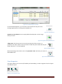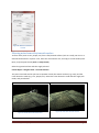
1
Leica Cyclone Basic User Manual July 2015 C.R.Kennedy & Company Page 1 Contents Copying Raw Files From the C10/P20 Scanner to the PC ................................................................... 6 Copy Raw files from the USB stick to the PC ...................................................................................... 6 Opening Cyclone ................................................................................................................................. 6 Database definitions ........................................................................................................................... 7 Project Folder .................................................................................................................................. 7 ScanWorld ....................................................................................................................................... 7 ControlSpace ................................................................................................................................... 7 ModelSpace .................................................................................................................................... 7 Scans ............................................................................................................................................... 7 Images ............................................................................................................................................. 7 Configuring the Server ........................................................................................................................ 8 Import Raw Scanner Files.................................................................................................................... 9 Import an Existing Cyclone Database................................................................................................ 12 If you have Photographs ................................................................................................................... 13 Importing Control into a Database ................................................................................................... 13 Registration (Combing Scans Together)............................................................................................ 14 Registration ScanWorld Groups .................................................................................................... 15 Registration with Targets .............................................................................................................. 15 Registration Without Targets – Manual Cloud to Cloud ............................................................... 16 Registration Without Targets – Visual Registration ...................................................................... 18 Registration Diagnostics................................................................................................................ 19 Unifying a ModelSpace ..................................................................................................................... 19 Adding / Renaming Targets............................................................................................................... 20 To add a target: ............................................................................................................................. 20 To name or rename a target ......................................................................................................... 20 Using modelled objects as targets .................................................................................................... 21 ScanWorld Explorer .......................................................................................................................... 21 View Properties ................................................................................................................................. 22 Layers ............................................................................................................................................ 23 View As .......................................................................................................................................... 23 Select/Visible Tab .......................................................................................................................... 24 3D Modelling ..................................................................................................................................... 24 Modelling Cylinders/Pipes from the Cloud ................................................................................... 24 C.R.Kennedy & Company Page 2 Modelling Cylinders Automatically ............................................................................................... 25 Modelling Cylinder Components .................................................................................................. 25 Modelling Pipe Objects without the Point Cloud.......................................................................... 28 Modelling Patches......................................................................................................................... 28 Modelling Steel Beams – Fit to Cloud Method ............................................................................. 32 Modelling Steel Beams – Extrude Shape Method (Cyclone 9.0) .................................................. 34 Modelling Boxes (Cuboids) ........................................................................................................... 34 Modelling Spheres ........................................................................................................................ 34 Modelling Targets ......................................................................................................................... 34 Modelling to standard sizes .......................................................................................................... 35 Merging models back into the original Model Space ................................................................... 35 Object Handles .............................................................................................................................. 35 Quick Move ................................................................................................................................... 35 Copying Multiple Models .............................................................................................................. 36 Changing the Appearance of Modelled Objects ........................................................................... 36 Grouping Modelled Objects .......................................................................................................... 36 Fit Edge Tool.................................................................................................................................. 36 Import/Export DXF files with Cyclone ........................................................................................... 37 Model Library .................................................................................................................................... 37 To Import a Model from the Model Library.................................................................................. 37 To Save a Model to the Model Library .......................................................................................... 38 Geo Tags............................................................................................................................................ 38 Creating a TruView............................................................................................................................ 39 Key Plans ........................................................................................................................................... 39 Limit Boxes ........................................................................................................................................ 39 Fences ............................................................................................................................................... 40 Viewing Modes ................................................................................................................................. 41 Perspective view ........................................................................................................................... 41 Orthographic view......................................................................................................................... 41 Seek ............................................................................................................................................... 41 View Mode .................................................................................................................................... 41 Pick Mode...................................................................................................................................... 41 Multi-pick Mode............................................................................................................................ 41 Hide the Point Cloud ..................................................................................................................... 41 C.R.Kennedy & Company Page 3 Changing the coordinate system ...................................................................................................... 41 Interfering Points .............................................................................................................................. 42 Measurements .................................................................................................................................. 43 Measuring Clearances using Patches ................................................................................................ 44 Measuring Clearances using Clearance Command ........................................................................... 45 Filtering noise from a flat/smooth surface ....................................................................................... 46 Alignment & Sections – Cyclone 8.0 ................................................................................................. 47 Alignment & Sections – Cyclone 9.0 ................................................................................................. 48 TIN Meshes ....................................................................................................................................... 50 Creating a TIN Mesh ...................................................................................................................... 50 Removing Spikes from a Mesh ...................................................................................................... 50 Filling in hols in a Mesh ................................................................................................................. 50 Sampling a TIN Mesh .................................................................................................................... 51 Creating Contours on a Mesh ....................................................................................................... 52 Colouring the mesh based on elevation ....................................................................................... 52 Calculating Volumes with Mesh.................................................................................................... 53 Decimating a Mesh ....................................................................................................................... 53 Extending a TIN Mesh to Break lines ............................................................................................ 53 Animation.......................................................................................................................................... 54 Cut Planes ......................................................................................................................................... 55 Point Cloud Density........................................................................................................................... 55 Point Cloud Rendering ...................................................................................................................... 56 Hot Keys ............................................................................................................................................ 56 Customise Hot Keys ...................................................................................................................... 56 Default Hot Keys ........................................................................................................................... 56 TruSpaces .......................................................................................................................................... 57 Exporting Point Clouds ...................................................................................................................... 58 Importing Point Clouds ..................................................................................................................... 58 Drawing ............................................................................................................................................. 58 Global Colour Map ............................................................................................................................ 59 Reducing Point Cloud Density ........................................................................................................... 59 Segment Cloud .................................................................................................................................. 59 Virtual Surveyor (VS) ......................................................................................................................... 60 Points on a Grid................................................................................................................................. 63 C.R.Kennedy & Company Page 4 Separating Overlapping Scans........................................................................................................... 63 Traverse Editor .................................................................................................................................. 64 Python Scripting ................................................................................................................................ 64 CloudWorx for AutoCAD ................................................................................................................... 65 Client License Manager ..................................................................................................................... 68 Activating a License ....................................................................................................................... 68 Returning a License to Rehost ...................................................................................................... 68 Ports that need to be opened on a network ................................................................................ 69 AutoCAD & Cyclone license conflict.............................................................................................. 70 Client License Manger over a VPN ................................................................................................ 70 Client License Manager Proxy Error .............................................................................................. 70 Cyclone Graphics Options ................................................................................................................. 70 Cyclone cannot find or verify the license server (either on my own computer or on a server). ...... 71 Cyclone has a trusted storage error message................................................................................... 72 Useful Websites ................................................................................................................................ 75 Technodigit 3D Reshaper .................................................................................................................. 75 Table of Figures ..................................................................................................................................... 76 C.R.Kennedy & Company Page 5 Copying Raw Files from the C10/P20 Scanner to the PC Connect the lemo/ethernet cable into the scanner and PC. Not there are two lemo sockets in the scanner; one with 7 pins and one with 5. Connect to the 7 pin socket. Open the program “C10 Data Copy” or “P20 Data Copy”. This can be downloaded from the Leica MyWorld website. The program will automatically find a scanner connected to the Ethernet port. If after 5 minutes the scanner is not found automatically, make sure your network adapter settings in Windows are set to “Obtain an IP address Automatically”. These should be the default settings. Figure 1. C10 Data Copy program. Click on Find Scanners -> Continue. A window with two sections will appear. The view on the left is the Scanner’s Hard Drive. The view on the rights is the PC’s hard drive. Select the Project and the destination folder, click Copy Projects. For Ok Tedi the destination folder is D:\laser scans\. Once finished, close C10DataCopy and shut down the scanner. Copy Raw files from the USB stick to the PC If you wrote files directly to the USB stick with the scanner, plug the USB stick into your PC, and copy the raw files to your PC (for OK Tedi, D:\laser scans\). Opening Cyclone Open Cyclone by clicking on the Cyclone icon on your desktop, or Start -> All Programs -> Leica Geosystems -> Cyclone 8.0 -> Cyclone. This will open the Cyclone Navigator. Figure 2. Leica Cyclone icon. C.R.Kennedy & Company Page 6 If you’re running Cyclone for the first time, you should turn off Survey mode (it displays the individual scans in their own folders). Turn Surveyor off mode: Edit -> Preferences -> Scan -> Survey Mode: No. Ensure that Level is set to Default. Figure 3. Cyclone Navigator Database definitions A cyclone database is made up of several modules. Project Folder - This folder contains all your scan data. You can create new project folder (Create > Project) to re-organise your scan data. ScanWorld – Each scan position is called a ScanWorld. ControlSpace – This is a point cloud that contains all the scan data and targets. Only open a ControlSpace if you need to make adjustments to targets. When you combine scans in a registration, Cyclone refers only to the ControlSpace, not the ModelSpace. Normally you never have to access the ControlSpace. ModelSpace – This is also a point cloud that contains all the scan data and targets. Use the model space for your point cloud work (viewing, modelling, fencing, deleting, meshing, etc). You can create multiple ModelSpaces by copy/paste, or using the fence tool inside a ModelSpace. Scans – This folder contains all the point cloud data that you acquired whilst scanning, including targets. You only need to access this data to separate scan data into multiple ModelSpaces. Images – This folder contains the photograph that you took with the scanner. By double clicking on MultiImage, you can see all the photos that were acquired. C.R.Kennedy & Company Page 7 Figure 4. Cyclone navigator definitions. Configuring the Server Using (unshared) will improve Cyclone’s performance since the Shared folder is meant to prepare the data to flow through a network. Right click on Servers folder, the menu will appear. See Figure 5. Click on Servers… Uncheck the Shared server box if it is checked. See Figure 6. Figure 5. Right click on Servers folder Figure 6. Deactivate shared Server. C.R.Kennedy & Company Page 8 Import Raw Scanner Files When you import raw files from a scanner, you need to first create a Cyclone database. Cyclone navigator window - Configure -> Database -> Add Figure 7. To create a new database. Figure 8. Adding a name to a new database. Add any filename that you like. Leave Database Filename field empty (no Cyclone database has been created yet). The database has been created. Right click on the blue database icon that you just created, Import ScanStation Data -> Import ScanStation Project. Use when you’re importing raw scan data for a new project. C.R.Kennedy & Company Page 9 Import ScanStation Data -> Import ScanStation Partial Project Use when you’re adding raw scan data into an existing project. Figure 9. Import ScanStation Data menu. Select the root folder of the raw files. C.R.Kennedy & Company Page 10 Leave all the import setting at default: Sampling – 100% (what percentage of the point cloud density to import) Find Black & White (B&W) Targets – off (unless you had black & white targets and did not pick them on the scanner) Auto Align Scans – Will automatically join scans with 25% or more overlap. Generate Scan Thumbnails – Used for Visual Alignment of scans. Map Colours – off (applies the photos to the point cloud but does not blend them) Estimate Normals – on (needed for adding manual Cloud Constraints in Registration) Find Pipes Automatically – off (unless you have pipes that you want modelled automatically). Figure 10. P20 scanner import settings When importing P20 data into Cyclone, ensure you turn check the 'Remove Mixed Pixels' menu during data import. This will reduce the amount of noise from laser flare in the data. Figure 11. P20 Scanner Import Settings C.R.Kennedy & Company Page 11 Import an Existing Cyclone Database Cyclone navigator window - Create -> Database -> Add Figure 12. Adding a new database. Select the Cyclone database .IMP file. Figure 13. Selecting an existing Cyclone database. C.R.Kennedy & Company Page 12 If you have Photographs When importing raw scanner data with photographs, the photos will need to be blended and applied to the point cloud. Right click on the project folder under the database icon -> Batch Blend Multimages - This corrects the brightness/contrast of the photographs, to make the images look like one continuous photo. Right click on the project folder under the database icon -> Batch Apply MultiImages - This colourises the point cloud with images from the camera. Figure 14. Batch Blend & Apply Images Importing Control into a Database Cyclone can import survey coordinates of targets into a database. Surveyors refer to this a importing control, or applying grid coordinates. Right click on the project folder -> Create -> Scanworld. Call it whatever you like, e.g. “Control”. Right click on the ScanWorld -> Import. Select the .txt file containing your control. Note, the control should be in CSV format, but renamed to a .txt file extension. You can have your values separated by commas, spaces, semicolons, or tabs. Make sure each column has the correct definition. The column containing the target names must be called “Target ID”. The columns for X,Y,Z (or E,N, El) coordinates must also be correctly named. You can change column type by clicking on it. One done, click Import. Open the control ModelSpace. You will now see only targets, with the coordinates that you’ve imported. Remember, when you create a registration with control, add the ScanWorlds including the control one, and right Click on the Control ScanWorld -> Set Home ScanWorld C.R.Kennedy & Company Figure 15. Import control settings. Page 13 Registration (Combing Scans Together) Leica defines a Registration as: “Registration is the process of integrating a project’s ScanWorlds into a single coordinate system as a registered ScanWorld. This integration is derived by a system of constraints, which are pairs of equivalent tie-points or overlapping point clouds that exist in two ScanWorlds. The Registration process computes the optimal overall alignment transformations for each component ScanWorld in the Registration such that the constraints are matched as closely as possible.” Click on your project folder under your database. Click Create -> Registration, call it whatever you like. Double click on the registration icon to open it. Figure 16. Registration icon. Scans are referred to as ScanWorlds. To add your scans into the registration, click Scan World -> Add Scan World. Select the scans you wish to combine, and copy them to the registration. If you added control, make sure you select the control ScanWorld as well. Click OK. Figure 17. Adding ScanWorlds to a Registration. C.R.Kennedy & Company Page 14 You should now see your scans in the “ScanWorlds’ Constraints” tab. If you have control, right click on the control ScanWorld -> Set Home ScanWorld. Registration ScanWorld Groups In Cyclone 9.0, ScanWorlds can be automatically grouped together based on common constraints or common overlap. Separate groups of ScanWorlds can be easily joined together using the “Manual Cloud to Cloud” or “Visual Registration” methods, see below. You can automatically group ScanWorlds together by selecting ScanWorlds in a registration, right click -> Create ScanWorld Groups …. Figure 18. Setting the Control ScanWorld as the home ScanWorld. Registration with Targets Targets are referred to as “Constraints” in Cyclone. To add targets click on Constraints -> Auto Add Constraints. You can see the targets on the Constraints List tab. Figure 19. List of constraints on the Constraints List tab. Notice that the errors have not been computed under the Error column (the value is N/A). To calculate the errors, click Registration -> Register. C.R.Kennedy & Company Page 15 Sort the errors by value by clicking on the Error column bar. If you have errors above 6mm, I would suggest disabling them (right click ->Disable). Then re-calculate the errors by clicking Registration -> Register. Once you’re happy with the error values, click Cloud Constraint -> Auto Add Cloud Constraints. This feature examines scans that have at least 20% overlap, identifies common objects in the point clouds, and further aligns the scans based on these common objects. The cloud constraints are added to the Constraint List tab as “cloud/mesh”. Figure 20. Cloud constraint registration progress Once done, click Registration -> Create ScanWorld / Freeze Registration. Then to view the data click Registration -> Create and Open ModelSpace. Look at your registration file in the Cyclone Navigator. It now looks like a normal ScanWorld, with all the scans aligned perfectly together. Registration Without Targets – Manual Cloud to Cloud If you did not have any targets in a ScanWorld, you will need to manually identify common points between two scans. Rather than adding constraints automatically like before, we have to add them manually. Click: Cloud Constraint -> Cloud Constraint Wizard. Figure 21. Cloud Constraint Wizard matrix C.R.Kennedy & Company Page 16 In the Cloud Constraints Wizard, you have to select which scans are overlapping. In this example, I’ve selected scans 1 & 2, scans 2 & 3, and scans 3 & 4. Click Update. Figure 22. Cloud Constaints Wizard window Move the Cloud Constraints Wizard window away, but do not close it. You will now see two windows displaying two point clouds on Cyclone. Using the multipack mode, click on at least 3 common points on each scan with at least 100mm accuracy. Figure 23. Multi-Pick mode icon . Try and spread the points around as much as possible. Then click on Preview in the “Cloud Constraints Wizard” window, and view the combined scans to confirm that they are aligned. If you have you not picked enough points or spaced your points around enough, Cyclone will tell you with an error message. Simply add to the points that you have already picked, and click Preview again. When you click Preview, visually check that the scans are aligned. Then close down the ModelSpace preview, and click “Constrain” on the Cloud Constraints Wizard. The wizard will automatically progress to the next combination of scans. Once you have combined all the scans, notice that Cloud/Mesh constraints are now in the Constraints List tab. The errors will need to be calculated; Registration -> Register. Confirm that all the errors are minimal. If not, delete the Constraint and recombine the scans again using the Cloud Constraint Wizard. If you’re happy with the errors, click: Registration -> Create ScanWorld / Freeze Registration, then Registration -> Create and Open ModelSpace Look at your registration file in the Cyclone Navigator. It now looks like a normal ScanWorld icon. Figure 24. ScanWorld icon of a completed registration. C.R.Kennedy & Company Page 17 Registration Without Targets – Visual Registration Registration without targets can also be performed using the Visual Registration method in Cyclone 9 onwards. By generating 2D thumbnails of point cloud data, you can visually align two point clouds together much faster than the manual cloud to cloud method. First, generate the thumb nails. In Cyclone Navigator, select the scans, right click -> Re/Generate Scan Thumbnails. In Cyclone Navigator, create a new registration (Create -> Registrion). Open the Registration (double click). Add the ScanWorlds (ScanWorlds -> Add ScanWorlds). Automatically group the ScanWorlds (select the ScanWorlds, right click -> Create Scan World Groups with ….). Align 2 groups together. Visual Registration -> 2D Scan Thumbnails. Figure 25. 2D Scan Thumbnails window. C.R.Kennedy & Company Page 18 Figure 26. Visually aligning the 2D thumbnails. Registration Diagnostics A full report on a registrations diagnostics can be easily generated. Open the registration, and click Registration -> Show Diagnostics. The report will display the errors of each constraint used. Figure 27. Registration diagnostics report. Unifying a ModelSpace Before you start modelling or do any further changes to the registration, unify the registration that you have done. Even though the registered ScanWorlds look like one single point cloud, they are still treated as separate point clouds in a ModelSpace. Unifying results in better resource allocation of your PC’s memory. C.R.Kennedy & Company Page 19 Once you unify a ModelSpace, you cannot un-unify it. So it’s a good idea to a make a copy first. To make a copy of a ModelSpace, right click -> Copy, then under the ModelSpace folder, right click -> Paste. To unify, right click on the new ModelSpace -> Unify ModelSpace. You have the option to reduce the point cloud density. This is useful, as it reduces the number of points in the cloud, improving performance in Cyclone. I recommend a 3mm reduction in points for modelling purposes. Once done, click Unfiy. Figure 28. Unify cloud options. Adding / Renaming Targets To add a target: Click on the centre of target with the Pick Mode, and then Create Object -> Fit to Cloud -> HDS Target or Black/White Target. Figure 29. Pick Mode icon. To name or rename a target Click on the centre of target with the Pick Mode, and then Tools -> Registration -> Add/Edit Registration Label. C.R.Kennedy & Company Page 20 Figure 30. Naming/renaming a target. Figure 31. Changing a targets value (name). Using modelled objects as targets Cyclone can use modelled objects as targets. For example, you can use a modelled pipe as object. Select the pipe, and click Tools -> Registration -> Add/Edit registration label A 3 plane corner (i.e. in a room where the ceiling and two walls intersect), can be very accurately defined by Cyclone and can be used as a target. Create Object -> Fit Fenced -> Corner (vertex added automatically). Click on the vertex, then Tools -> Registration -> Add/Edit registration label. ScanWorld Explorer The ScanWorld Explorer is a useful tool to turn on/off point clouds in a registration. You cannot do this once you have unified the cloud. To access the ScanWorld Explorer open the ModelSpace of a registration, and click Tools -> Scanner -> ScanWorld Explorer. C.R.Kennedy & Company Page 21 Figure 32. ScanWorld Explorer window. In the ScanWorld Explorer, you can hide or show clouds that are part of the existing registration by un-ticking the viewable icon: Figure 33. Viewable icon. Segment scan by distance. You can apply delete data beyond a certain range from your scans. Figure 34. Segment scan by distance icon. Allign View. This function puts you into the perspective of the scanner in a particular scan. NB: A short cut to this view is to select the point cloud with the pickmode, and press “a” on the keyboard. Figure 35. Align view icon. Note that the align view mode is set to the panoramic view. This locks your view in a 360° bubble view. Figure 36. Panoramic View icon. View Properties This option allows you to turn on/off visibility and selectability, as well as segment cloud or objects into different layers. Figure 37. View Properties icons. C.R.Kennedy & Company Page 22 Figure 38. View Properties window. Notice that there are three main tabs: Layers, View As, and Selectable/Visible. Layers You can select points, meshes, or modelled objects, and assign them to a layer of their own. This is useful if you wish to hide certain objects, or group the same objects together (e.g. assign all cylinders to their own layer). View As You can set the resolution of object in the View As tab. For example, a mesh can be viewed in high resolution (LOD – Full Range) or as a wireframe. Figure 39. View Properties - View As tab. C.R.Kennedy & Company Page 23 Select/Visible Tab This tab gives you the option allowing an object to be visible, and also selectable with the pick mode. 3D Modelling Cyclone is a very powerful tool for modelling pipes, steel beams, valves, boxes, patches and other objects. When modelling pipes and steel beams, Cyclone can model to standard sizes. To activate this mode, click Create Object -> Use Parts Table. You can choose the database to use by clicking Edit -> Object Preference. There are five ways to model: Region Grow, Fit to Cloud, Fit to Fence, 2D Draw and Insert Object. When modelling objects from the point cloud using Region Grow commands, the objects point cloud will be made invisible. At any time you can show the objects cloud by selecting the modelled object, and clicking Create Object -> Insert Copy of Objects Points. Figure 40. Plant objects can easily be modelling Cyclone. Modelling Cylinders/Pipes from the Cloud You can model pipes in your original ModelSpace. To model a single pipe, select the pipe with the pick mode, click Create Object -> Region Grow -> Cylinder. Figure 41. Modelling a single pipe. To model a pipe run, click on the separate parts of the pipe with the multi pick mode, click Create Object -> Region Grow -> Pipe Run. C.R.Kennedy & Company Page 24 Figure 42. Modelling a Pipe Run of 3 sections. Pipes can also be modelled automatically, Create Object -> Find Pipes Automatically. The function will not work on a unified pipe cloud, and will not add pipe elbows, only straight pipes. Pipes can be connected with elbow or mitre connections, or reducers can be added to the end of pipes. These functions can all be found in the Piping menu, under Tools -> Piping. Figure 43. Piping Menu Modelling Cylinders Automatically Cyclone 8.0 onwards can scan the point cloud and model pipes automatically. Note, this cannot be done on unified points clouds. To begin the process, select the point cloud (Selection -> Select All), and click: Create Object -> Find Pipes Automatically You may wish to colourise the cylinders different colours. To do so, click: Edit Objects -> Appearance -> Create Objects from Random Colours You can filter cylinders by size by clicking: Create Objects -> Filter Pipes Modelling Cylinder Components There are several other options with pipes. Valves, blind flanges, wielding neck flanges, reducers, and tee joins must be fitted by eye. You cannot “region grow” or “fit to cloud” a valve. Using the C.R.Kennedy & Company Page 25 handles, adjust the size to best match the cloud. To add these objects, click on the end handle of a pipe, then Create Object -> Insert -> …. Elbow Join An elbow join is a continuous smooth pipe join. Note, pipe runs will add elbow joins between pipes automatically. Figure 44. A pipe join Mitres Join A mitre join is made of multiple pipe cross sections. It is not a smooth continuous join like an elbow. Figure 45. A 3 section mitre join. Blind Flange Wielding Neck Flange Concentric Reducer 2 Cylinders of different diameter joined together with a Concentric Reducer. Eccentric Reducer 2 Cylinders of different diameter joined together with an Eccentric Reducer. C.R.Kennedy & Company Page 26 Figure 47. Eccentric Reducer. Figure 46. Concentric Reducer. Valves Create Object -> Insert -> Valve. Figure 48. Modelled valve. C.R.Kennedy & Company Tee Joins: Figure 49. Modelled Tee join. Page 27 End Caps You can add end caps to cylinders: Edit Object -> End Caps -> Figure 50. Flat (left) and Semi Elliptical (right) Caps. Modelling Pipe Objects without the Point Cloud Pipe objects (pipes, elbows, flanges, etc), that have not been scanned or do not yet exist can be modelled from within Cyclone. For example, a new pipe run can be added into the pipe cloud, and point cloud collisions can be ran to determine the pipe will fit correctly. Tools -> Piping -> Pipe Modelling Modelling Patches A patch is a 2 dimensional plane. Patches can be used to model flat objects, such as walls, ceiling, floors, etc. Figure 51. Modelling objects not in the point cloud. Holes can be cut into patches, so long as they do not cut through the perimeter. Patches can be extruded to become 3 dimensional objects. Once extruded, holes cannot be cut into them. C.R.Kennedy & Company Page 28 Select a point on the surface with the pick mode, then click Create Object -> Region Grow -> Patch. Normally there will be numerous handles and corners. The patch can be made rectangular by selecting the patch, then Edit Object -> Patch -> Make Rectangular. NB: In the above example, a patch could also be created using by drawing a 2D polygon against the XY reference plan. Cutting fences from a Patch Objects such as doors and windows can be cut out of the patch using the fence tool. It is best to view the patch in orthographic mode when making cuts. NB: A fence cannot be cut beyond the perimeter of the patch. Create Object -> Insert Copy of Objects Points C.R.Kennedy & Company Page 29 Figure 52. Changing the visibility of the patch. Note the rectangular fence over the doorway. Figure 53. Patch with fenced area removed. Extruding Patches Extruding a patch give it depth and becomes a 3D object. A patch is only a 2D flat surface. Once a patch has been extruded, fences can no longer be cut from it. Figure 54. An extruded patch with depth. Extending Patches Select the patches, and select Edit Object -> Extend -> Extend All Objects. C.R.Kennedy & Company Page 30 Figure 55. 3 Patches before extension. Figure 56. 3 patches after extension. Note the corner. C.R.Kennedy & Company Page 31 Modelling Steel Beams – Fit to Cloud Method With Steel Beams, you must copy the beam to a new ModelSpace. Fence out a steel beam using the fence tool, right click -> Copy Fenced to New ModelSpace. Clean up the steel beam by using the polygonal fence tool, and right click -> Fence -> Delete Outside or Delete Inside. The steel beam point cloud should look like the below figures. Figure 58. Top down view of cleaned up steel beam. Note that the view is in orthographic mode, not perspective mode. Figure 57. Side view of steel beam. To model a steel beam, click on the beam with the pick mode, and then Create Object -> Fit To Cloud -> Steel Section -> Wide Flange NB: You can also fence the beam, right click -> Fit Fence -> Steel Section -> Wide Flange. Steel beam Angle, channel, Tee, rectangular tube, and wide flange (I-beams) steel beams can all be modelled in Cyclone using the above method. C.R.Kennedy & Company Page 32 Angle: Channel: Figure 59. Steel Angle Beam Tee: Figure 60. Steel Channel Beam. Rectangular Tube Figure 61. Tee Steel Beam. Figure 62. Rectangular Steel Beam. Wide Flange (I-Beam or H-Beam): Figure 63. Wide Flange Steel Beam. C.R.Kennedy & Company Page 33 Modelling Steel Beams – Extrude Shape Method (Cyclone 9.0) In Cyclone 9.0, steel beams can modelled from 2 picks without having to clean the cloud. Using the multi-pick tool, pick two points on a steel beam. Create Object -> Extrude Shape (2 picks) -> Wide Flange. NB: This function will only model to dimensions in the database. Create Object -> Use Parts Table must be ticked and enabled. NB: The area around the cross section of the picks on the steel must be clean of noise for 20mm on each side of pick see image. Figure 64. Cyclone 9.0 can model steel beams using the multi-pick method. Modelling Boxes (Cuboids) Like steel beams, boxes can only be modelled from point clouds using the Fit to Cloud command. Therefore, you must first fence and copy a box to a new model space, isolate the box point cloud data, then Create Object -> Fit to Cloud -> Box. Modelling Spheres Like steel beams, spheres can only be modelled from point clouds using the Fit to Cloud command. Therefore, you must first fence and copy a sphere to a new model space, isolate the sphere’s point cloud data, then Create Object -> Fit to Cloud -> Sphere. Modelling Targets Scanner targets (HDS target, black/white target, or sphere target) can be modelled in Cyclone. Select the target with the pick mode. You do not have to select the centre of the target. Create Object -> Fit to Cloud -> Note, you do not have to isolate the target. If there is enough point data on the target, Cyclone will automatically add a vertex in the centre of the target. C.R.Kennedy & Company Page 34 Modelling to standard sizes In Leica Cyclone, you can create modelled objects to sizes in a database. To do this, click Edit -> Object Preferences, and select the Object Type. When you next model this object, Cyclone will best fit the dimensions to a list of standard sizes from a database. Databases are located in the directory: C:\Program Files\Leica Geosystems\Cyclone\Lib\Tables Merging models back into the original Model Space Figure 65. Object Preferences Window. Figure 66. Closing ModelSpace View. Once the model has been made, close down the ModelSpace windows, and check “Merge into original ModelSpace” and “Delete after close”. Object Handles Handles are contained in objects within Cyclone that are used to adjust the object’s position, orientation, and size. Handles are colour coded to indicate the movement type. • Red – Rotate • Orange – Resize, translate, and snap • Blue – Translate and snap You can move objects in Cyclone, and restrict the movement to a 2 dimensional plane. Edit Object -> Handles -> Constrain Motion To -> ….. Left click on an orange handle, and hold Ctrl to move an object. Left click on an orange handle, and hold Shift to will snap handles to each other. Quick Move A modelled object can be moved easily with the Quick Move command. Select 2 points on the model (click on the blue handles) with the multi-pick mode, then select two corresponding points on the point cloud, and Edit Object -> Quick Move. This is much faster than manually dragging an object. C.R.Kennedy & Company Page 35 Copying Multiple Models A modelled object can be copied multiple times. This is useful, for example, if you wish to copy a steel beam every 5 metres in the X-axis directions. Select the object with the pick mode, then click Create object -> Copy. Changing the Appearance of Modelled Objects Modelled objects can have their appearance (e.g. colour, transparency, etc) customised in Cyclone. Select the object with the pick mode, then click Edit Object -> Edit Colour/Material Grouping Modelled Objects Multiple objects can be grouped together as a single objects. This makes it easier to move the objects together, or to assign them all to a layer. Select all objects with the Multi Pick mode, then Edit -> Group -> Group Figure 67. 3 modelled objects grouped. Fit Edge Tool The Fit Edge tool is used for creating a polyline the follows an edge. Create Object -> Fit Edge C.R.Kennedy & Company Figure 68. Point cloud of a step. Page 36 A cross section view point of the edge should appear in the Fit Edge window, along with a vertex. If not, rotate the point cloud manually and add a vertex on the edge. Multiple vertexes can be added if required. The nodal point indicates the position where a polyline will be created. Figure 69. Fit Edge window with cross section view on point cloud. Figure 70. Point cloud with added polyline (in grey). Import/Export DXF files with Cyclone Modelled objects in Cyclone can be exported as a DXF, and viewed in 3rd party CAD programs (such as AutoCAD or MicroStation). To export a model from Cyclone, select the item(s), and click File -> Export, and selected AutoCAD DXF R12 Format (*.dxf). Cyclone can only import COE (Cyclone Object Exchange) objects. It cannot import DXF objects directly. To import DXF models into Cyclone, you have to convert them into COE files using the Leica COE data transfer plugin for AutoCAD or MicroStation. Model Library Cyclone has a model library for commonly used objects. You can add or load models to/from the library easily. To Import a Model from the Model Library Tools -> Model Library Manager -> Insert Model C.R.Kennedy & Company Page 37 Figure 71. Insert Model window. To Save a Model to the Model Library Take a screenshot of your model and save it as .jpg file. Copy the model into a new Model Space. Select All, then click Tools -> Model Library Manager -> Save Model. Create a new name for a Library, Assembly and load the screenshot of the model. Geo Tags A Geo Tag allows you to add additional meta data to the point cloud in Cyclone. Geo Tags will be automatically saved into a Leica TruView when created. Tools -> Geo Tags Figure 72. Geo Tags window. C.R.Kennedy & Company Page 38 Creating a TruView A TruView allows to you share the scan data in internet explorer. You will first need to download and install a plugin for internet explorer. Google the term “Leica TruView download”, and download the link. To create the TruView, open the ModelSpace that you wish to share. Zoom out so that you can see all the scan station positions. This will be the site map of your TrueView. Once done click File -> Publish Site Map. Create a folder where you want the TrueView to be -> OK. Select your ScanWorld -> OK. Click TruView Settings button. Click Color Map Settings. Figure 73. TruView Settings If you have photographs, set the mode to “Colours from Scanner”. If you do not have photographs, set the mode to “Intensity Map.” For “Intensity Map” mode, you set the scheme to either greyscale or Multi-Hue/Rainbow. In Grayscale mode, you can adjust the darkness with the Gamma setting. Once the TruView is created, open the folder, and click SiteMap.htm. NB: The TruView plugin will only work with Microsoft Internet Explorer. You can download the TruView plugin from the Leica website: http://hds.leica-geosystems.com/en/Leica-TruView_63960.htm Figure 74. TruView Colour Map Settings Key Plans A key plan allows you to easily share point cloud data locked into the perspective of the scanner, with anyone that has Cyclone installed. It is very similar to a TruView, except a Key Plan must be ran in Cyclone. Cyclone can be installed without a license and used as a viewer. File -> Create KeyPlan A background image (e.g. from Google Maps) can be imported. Select 2 scanner setups to align it. Limit Boxes Limit boxes are a useful way to view a small volume of data in a large point cloud. Open a ModelSpace, click C.R.Kennedy & Company Page 39 View -> Set Limit Box by Cursor, or View -> Set Limit Box by Fence. Notice that now the data is limited to just the box. To turn off the limit box, click View -> Limit Box. You can increase the size of the limit box with the multipack mode. Click on the limit box, and then drag the handles (the orange squares). Figure 75. A car in a limit box. Limit Boxes can also be saved and loaded in the Limit Box Manager: View -> Add/Edit Limit Boxes. The saved Limit Boxes in Cyclone can also be viewed in AutoCAD Cloudworx with the Clipping Manager tool. Limit boxes can also be aligned to an axis. Select the limit box, then click Edit Object -> Align -> Align to Axis -> XYZ Axis. Fences Fences are another useful way of isolating or deleting points from the point cloud. There are 3 fence modes: Polygonal Fence, Rectangular Fence and Circular Fence. Figure 76. Fence tools (polygonal, square, circular, and cancel). C.R.Kennedy & Company Page 40 Viewing Modes Perspective view: Shows the point cloud with depth of field. Orthographic view: Shows the point cloud with no depth of view. Figure 77. Perspective icon. Figure 78. Orthographic icon. Seek : Focuses the view on a point in the point cloud. The shortcut is S on the keyboard. View Mode: Allows you to zoom, rotate and pan around a point that you selected with Seek. Figure 79. Seek icon Figure 80. View Mode icon Pick Mode: Allows you to pick a point in the point cloud. The co-ordinates will be displayed at the bottom of the screen. Hold down Shift to pick multiple points. Multi-pick Mode: Same as the pick mode, but allows you to pick multiple points without holding down Shift. Figure 82. Multi-pick Mode icon. Figure 81. Pick Mode icon. Hide the Point Cloud: This icon depicts a pair of crossed out glasses looking at a cloud. This function is useful if you wish to hide the point cloud and only show modelled objects. Figure 83. Hide the point cloud Changing the coordinate system Cyclone allows you to easily transform the coordinate system of a point cloud. You may want to move the origin, or align a wall or object with the X or Y-axis. New coordinate systems can be saved, and the point cloud can easily switch between different coordinate systems. C.R.Kennedy & Company Page 41 Figure 84. Changing the Coordinate System. Interfering Points This function is useful for clash detection (i.e interference or collision of points) of a modelled object against the point cloud. For example, one could import a modelled pipe run for a new pipe, and confirm if the new pipe will fit against the existing cloud. Select the point cloud and the model (Selection -> Select All). Tools -> Measure -> Interfering Points Figure 85. Interfering/collision Points are highlighted in white. C.R.Kennedy & Company Page 42 Figure 86. Interfering / collision points are highlighted in white. Measurements Measurements can easily be made in Cyclone. Using the multi-pick tool, select tool points on a point cloud, and select: Tools -> Measure -> Distance -> Point to Point Tools -> Measure -> Edit Measurements You can add additional columns by right clicking on the top of a column, and selecting Customise. Distance – Slope distance (hypotenuse) dX – Change in X values dY – change in Y values dZ – Change in Z values. dH – Horizontal value dV – Vertical value (should be same as dZ) Figure 87. Saved Measurements' window. C.R.Kennedy & Company Page 43 Measuring Clearances using Patches This function is used to calculate the clearance height. For example, to calculate the minimum clearance height of a bridge over a road. Tools -> Measure -> Clearances In this example, a bridge is scanned from over 100m away using the Leica C10 whilst traffic was continually flowing. om a single point, we can see the bridge clearance is 17.4 ft, we can measure the entire length quickly. Figure 88. A point cloud of a bridge and freeway. Figure 89 Patch on the road surface under the bridge. Use the “Fit Edge” tool to place a polyline along the edge of the bridge. Select the edge with the pick mode, then click Create Object -> Fit Edge C.R.Kennedy & Company Page 44 Figure 90. Fit Edge tool. Tools -> Measure -> Point to Unbounded Surface (gives the true vertical distance to a patch). In this example, a different height is found in each lane. By using the “Fit Edge” tool, you can calculate better clearance values then picking points in the field by eye. Figure 91. Clearance height distances from patch to polyline. Measuring Clearances using Clearance Command Bridges clearances can also be calculated using the Clearance command without modelling patches or edges. First, you will need to use the multipick to pick a two point on the road, and then two more points above the road on the underside of the bridge. Tools -> Measure -> Clearances C.R.Kennedy & Company Page 45 Figure 92. Measure Clearances' window Filtering noise from a flat/smooth surface To filter noise (such as cars, people, etc) from a flat/smooth surface (such as a road), we can run a Smooth Surface filter in Cyclone. First, fence the area interest out, and copy to a new model space. Next, unify the point cloud (Tools -> Unify Clouds). Select the ground surface with the single pick tool. Create Object -> Region Grow -> Smooth Surface. The point cloud will now be split into 2 separate clouds; the smooth surface (e.g. road), and the noise above the roads (e.g. cars, people, etc). Select the noise above the road with the single pick mode, and press delete. Figure 93. Road before Smooth Surface C.R.Kennedy & Company Figure 94. Road after Smooth Surface Page 46 Alignment & Sections – Cyclone 8.0 An alignment on a road can be easily created in Cyclone, and broken into sections. The individual sections can be modelled with a poly line automatically. Note, Cyclone cannot perform tunnel alignments. Technodigit 3D Reshaper software is required for tunnel alignments. Fence an area of a road. Select two points on a road surface with the Multi-Pick tool, and click Create Object -> From Pick Points -> Alignment. If the road surface is curved, you can create a polyline. If you need to filter the noise, see the previous chapter “Filtering noise from a flat/smooth surface”. Next, create the alignment; Tools -> Alignment & Sections -> Create Alignment, then create sections; Tools -> Alignment & Sections -> Create Sections. A list of sections will be displayed. The individual sections can be inspected by click on the station in the Station column. Figure 96. Alignment Create Sections window. Figure 96. Alignment Section Manager Figure 97. Note that the polyline will follow the alignment. The handles of the polyline can be manually adjusted to better follow the point cloud if needed. Point cloud data can be copied with the alignment by selecting “collect points” in the “Create Sections” window. C.R.Kennedy & Company Page 47 Figure 98. Alignment sections with point cloud. The polyline alignment and centre line can be exported as a DXF file. File -> Export -> (select AutoCAD DX R12 format). Alignment & Sections – Cyclone 9.0 In Cyclone 9.0, a new Alignment tool was released that includes a plan view window. Cyclone 9 introduces a new tool for Topo feature extraction. Tools -> Roadway Alignment & Section -> Create Alignment -> Alignment Section Manager This tool allows you to quickly break an alignment into sections, and draw string lines of features down an alignment (e.g. top of curb, edge of curb, bottom of curb, etc). First, an alignment must be drawn. Select two points using the multipick tool, then click Create Object -> From Pick Points -> Line Segment. Next, turn your line segment into an alignment. With the line segment selected, click Tools -> Roadway Alignment & Station -> Create Alignment Then open the Alignment / Station manager: Tools -> Roadway Alignment & Station -> Alignment / Station Manager Figure 99. Alignment Section Manger & Plan View in Cyclone 9.0. To create an alignment, enter in the desired values and click Create. The point cloud will now be split into sections, and a top down Plan View window be shown. C.R.Kennedy & Company Page 48 A new feature in Cyclone 9.0 is the ability to create templates. Click on the Template tab. C.R.Kennedy & Company Page 49 TIN Meshes Cyclone has a very powerful TIN mesh function. A TIN (Triangulated Irregular Network) is particular type of Digital Terrain Model (DTM) used to emulate surfaces. It should not be used for complex surfaces (e.g. people, statues, buildings, trees), but more simple surfaces such as a road or a stockpile. Creating a TIN Mesh Select the surface with the pick mode, click Tools -> Mesh -> Create Mesh -> TIN Meshing. You can view the mesh as a wireframe. Highlight the mesh (Ctrl + A), View -> View Object As -> Wireframe Figure 101. A TIN mesh when viewed as a solid Figure 101. A TIN mesh when viewed as a wireframe. Removing Spikes from a Mesh When you mesh a surface, occasionally random spikes will appear due to point cloud noise. To remove the spikes fence the spike using one of the fence tools. Right click, Fence -> Delete Inside. Figure 102 Mesh with spike. Filling in hols in a Mesh Select the perimeter of the whole using the pick mode. Tools -> Mesh -> Fill Selected Hole C.R.Kennedy & Company Page 50 Figure 104 Mesh with spike removed. Figure 103. Mesh with hole's perimeter selected. Sampling a TIN Mesh Note: Cyclone 9 has introduced a “Points on a Grid” tool that is similar to this function. A TIN mesh can be sampled against the reference plane to create a grid of points, vertexes, or as another mesh. First, add the reference plane. Tools -> Reference Plane -> Show Active Plane. Move the plane’s origin to the mesh. Tools -> Reference Plane -> Set Plane Origin at Pick Point Align the plan to the mesh. Tools -> Reference Plane -> Rotate Sample the mesh against the plane. Tools -> Mesh -> Sample Grid Hide the reference plane. Tools -> Reference Plane -> Show Active Plane Hide the Mesh. View -> Set Object Visibility Figure 105. A grid of points, sampled from a mesh. C.R.Kennedy & Company Page 51 Creating Contours on a Mesh Select the mesh (selection -> select all), and click Tools -> Contour -> Create Mesh Figure 106. Contours Parameters windows. Colouring the mesh based on elevation Edit Object -> Appearance -> Edit Global Colour Map. Under Mode, select Elevation Map. Figure 107. Mesh with contours and coloured based on elevation. C.R.Kennedy & Company Page 52 Calculating Volumes with Mesh You may have a need to calculate the volume of a stockpile. To do this: 1.) Isolate the point cloud that wish to calculate the volume of with the fence tool, and right click -> Copy To New Model Space. 2.) Select the isolated point cloud with the pick mode. 3.) Create the Mesh: Tools -> Mesh -> Create Mesh -> Tin. 4.) Click on the bottom of the mesh with the pick mode. 5.) Add the Reference Plane: Tools -> Reference Plane -> Set Plane Origin at Pick Point. 6.) Calculate the Volume: Tools -> Measure -> Mesh Volume -> Above Ref Plane. The volume area is now calculated Figure 108. Using a Mesh and Reference Plane to calculate a volume. Decimating a Mesh Often the mesh may be of higher resolution than needed. To reduce the number of triangles in the mesh, and hence the resolution, select the mesh (Selection -> Select All), and then click Tools -> Mesh -> Decimate Mesh. Usually a 10% reduction is sufficient. Figure 109. Decimate mesh parameters Extending a TIN Mesh to Break lines By creating a polyline along an edge (e.g. top of curb), the mesh can be extended to the breakline to create a sharp edge. First, create the break line. Pick a polyline along an edge, and click Create Object -> From Picked Points -> Polyline. Do the same for the bottom of curb. You could also use the Fit Edge tool to perform this. C.R.Kennedy & Company Page 53 Figure 110. Edge of curb selected with multi-pick. Tools -> Mesh -> Breaklines -> Extend TIN to Polyline Figure 111. Edge of curb when meshed. Animation A fly through animation through a point cloud can be created from within Cyclone. It may take some trial and error to achieve the correct frame rate. 1.) Add the cameras at intervals along your cloud: Create Object -> Insert -> Camera 2.) Create a path for the fly through by joining the cameras up: Tools -> Animation -> Create Path 3.) Tools -> Animation -> Set Path 4.) Hide the cameras and the path so they don’t show up in the animation. View -> Set Object Visibility -> Untick Camera and Polyline 5.) Tools -> Animation -> Animation Editor 6.) Tools -> Animation -> Animate Set frame rate around 50 and the resolution at 800 by 600. The animation will render quickly and you will be able to preview the product. Once animation is perfected, increase the frame rate to desired level and increase resolution to 1200 by 900. C.R.Kennedy & Company Page 54 Cut Planes Cut planes are useful if only wish to see a slice of the point cloud parallel to the X, Y or Z plane. I find it easier to use the icons of the Cut Plane toolbar. The Cut Plane menu is located under Tools -> Cut Planes. The easiest method is to first align the cut plane to a reference plane. Remember, reference planes can be on the XY, XZ, or YZ planes. First, adjust your coordinate system to be aligned with the object you want to slice. In the below example, the X axis is parallel to the front of the building (see the previous section “Changing the Coordinate System”). Next, show the reference plane you want. Tools -> Reference Plane -> Set to XY/XZ/YZ Plane. Click on the View Slice icon in the Cutplane toolbar. You can also set the thickness of the slice, and progress through sections on the point cloud. Using a single pick point with Quick Slice will result in a 1 meter slice thickness. Figure 112. Cutplane Toolbar Figure 113. Cut plane side view of a coal treatment plant. Point Cloud Density If you PC is lagging, you can reduce the number of points that are being displayed. View -> Point Cloud Density -> No Reduction / Low Reduction / High Reduction. Figure 114. Point cloud density Toolbar. C.R.Kennedy & Company Page 55 Depending on the power of your PC, you can increase the number of points that your computer loads and displays to produce a denser point cloud. Edit -> Preferences -> Point Cloud -> Load: Max Points / Display: Max Points Point Cloud Rendering View -> Point Cloud Rendering -> - Shaded - One-Sided: This mode will remove the points on a plane closes to the viewer. This is very useful when viewing a closed room. - Front - Back - Silhouette: The points closest to the viewer will be darkened, whilst the points furthest will be highlighted. This gives the impression of seeing through walls. Hot Keys Hot keys are keyboard shortcuts that can be saved for nearly all commands in Cyclone. They’re ideal for saving time and reducing mouse clicks for commonly used features. All functions on Cyclone can have a hotkey assigned to them. Customise Hot Keys Edit -> Customise Hot Keys Figure 115. Hotkeys menu. Default Hot Keys Some hot keys that are assigned by default are: Left Mouse – Rotate around the point of focus (use seek to reset the point of focus) Righ Mouse – Pan (moves the point of focus) Left + Right Mouse – Zoom C.R.Kennedy & Company Page 56 Scroll wheel button down on Mouse - Zoom Ctrl + Left Mouse – Turns the viewpoint around (i.e. “Look around”). Alt + Left Mouse – While in view mode, rotate slowly around focal. Spacebar – Deselect All s – Seek Seek Mode + Shift – Click on a point. The view will be shifted to the scanner’s perspective. i - Information (with an object selected) c – Coordinate system menu ~ - Toggle between Pick mode and View mode. d – Distance (measure distance between two points). f – Segment by fence Shift + i – Delete inside fence Shift + o – Delete outside fence C – Clear fence Shift + s – Set selectable Shift + l - layers TruSpaces A TruSpace is useful for viewing the point cloud from the perspective of the scanner. It’s a useful tool to manually add targets that were missed. View -> TruSpace -> Show TruSpaces Select a TruSpace with the pick mode, and click View -> TruSpace -> Open TruSpace. To link the TruSpace to the main ModelSpace, click View -> TruSpace -> Link TruSpace. C.R.Kennedy & Company Page 57 Figure 116. Truspace window (small). Exporting Point Clouds Point clouds can be exported in several formats. With the ModelSpace open, File -> Export, and select the format. The most common formats for point clouds are .pts, .ptx, and .txt. The easiest way to share a point cloud is to copy the Cyclone .imp database, and view the point cloud within Cyclone. Cyclone is free to use as a viewer. Importing Point Clouds Point clouds and raw scanner data (Leica, Z+F, Riegl and Faro scanners), can be imported directly into Cyclone. In the Cyclone Navigator, create a new database (Configure -> Database -> Add), enter a name. Once created, right click on the database -> Import. Some of the common formats are: Riegl (3dd, rxp, rsp), Z+F (zfs, zfc), Faro (fls, fpr, fws). Drawing You can use Cyclone to draw objects in 2D against the reference plane. This is useful if you wish to trace the outline of an object and then extrude it. Select a point with the pick mode that you wish to draw on against a plane, then Tools -> Reference Plane -> Set to….. Tools -> Drawing -> Draw Polyline Tools -> Drawing -> Create Drawing Create Object -> From Curves -> Patch NB: The reference plane can viewed as a XY, YZ, or XY plane. It can also be rotated and tilted to suit the object that you’re drawing to. C.R.Kennedy & Company Page 58 Turn the drawing to a 3D object, Edit Object -> Extrude Global Colour Map The colour representation of the point cloud can be changed in Cyclone. Edit Object -> Appearance -> Edit Global Colour Map This is useful if you wish to change the representation of reflectivity. Figure 117. Global colour map parameters. Reducing Point Cloud Density Using the pick tool, select the point cloud and click, Tools -> Reduce Point Cloud. NB: This function can only be used on point clouds that have not been unified. To reduce the point cloud density of unified point clouds, you can use the unify tool again (Tools -> Unify Clouds). Segment Cloud Figure 118. Reduce Point Cloud Density. It can be useful to separate a point cloud into small sections. Create Object -> Segment Cloud -> … - Cut Sub-Selection - Cut by Fence - Cut by Intensity… (Useful for cutting out noise from the scanner). - Cut by Distance from Point - Cut by Offset from Plane - Cut Near Ref Plane… - Trim Edges C.R.Kennedy & Company Page 59 Virtual Surveyor (VS) With Virtual Survey, you can extract features (points and 3D line data with point codes, line connecting codes, and comments) directly from point cloud in Cyclone, and then export these feature codes as a standard ASCII format into the surveying software of your choice. If you are using AutoCAD- or MicroStation-based platforms, the original raw point cloud can also be brought in (via CloudWorx) to verify the feature extractions and add detail to the existing topographic representation. Tools -> Virtual Surveyor When prompted, “Opening Existing VS File?”, click the Skip button to start a new VS file. A new VS window will appear. In the VS window, create a New Layer by clicking the Layers button, to put in the linework and give it a colour (optional). See Figure 1. Then click Set Current in the View Properties box, then click OK. Repeat this step for additional linework. • Enter or select a Feature Code (optional). See Figure 2. • Turn OFF the Automatic Candidate Features button. See Figure 3. • Multi-Select points. See Figure 3. • Click Start to create Polyline. See Figure 3. • Turn ON the Feature Code button. See Figure 3. • Check in candidate picks at the bottom of the VS dialog box. You can use the SmartPick tool by clicking View -> SmartPick Viewport. The SmartPick tool allow you to pick points within a defined radius of the cursor. The options are: 1. Closest Point (i.e. the closes point cloud point to the cursor. 2. Highest Point (i.e. the highest point within the cursor. E.g. the top of a tree). 3. Lowest Point. (i.e. the lowest point within the search radius. E.g. the bottom of a tree). 4. Ground Point. The SmartPick will interpret where the ground point by searching within a radius, even if there are no points directly where picked. NB: Clicking in the bottom right hand corner of the SmartPick View window will rotate the view. Figure 119. SmartPick View Window C.R.Kennedy & Company Page 60 Figure 120. Virtual Surveyor Menu A. Click to add a candidate feature with each pick. B. Show features in the ModelSpace viewer. C. Show candidate features in the ModelSpace viewer. D. Show unsaved features in the ModelSpace viewer. E. Highlight the current feature in the ModelSpace viewer. F. Show features options, which affect how features are displayed. G. Select to add a feature with each pick. H. Change the viewpoint to view the current feature. I. Adds one vertex to the ModelSpace for each feature. J. Exports the features directly to LandXML. K. Exports the features directly to the Leica System 1200 format. L. Invokes the Layers command. M. The prefix of the current feature. N. The point number that will be assigned to the candidate feature created from the next pick. C.R.Kennedy & Company Page 61 O. Displays coordinate data for the current feature. Click the arrow icon to edit the coordinate data. Click the lock icon to keep that value constant.. P. Select a feature code library. Q. List of values for the available attributes. R. The Create Lines area. Select the creation of a polyline or polygon, supply the Code Tags that will be prepended to each corresponding feature, then click the Start button. S. Click to customize the attributes displayed. T. Invokes the Customize Lookup Lists command. See Customize Lookup Lists for information on managing the libraries. U. Visibility of each attribute in the graphical window. V. Click to select or enter a value for the desired attribute. W. Undo last add features. X. Commit the candidate features. Y. Click to export current added features. Z. Click to close the Virtual Surveyor. C.R.Kennedy & Company Page 62 Points on a Grid Cyclone can place points within a fenced region by sampling the reference plane. This is very similar to sampling a mesh against the reference plane. Click Tools -> Points on a Grid. View the point cloud top down. Figure 121. Placing ground points on a grid. Separating Overlapping Scans In a Free Station scanning mode, if a user forgets to hit Standard Setup (StdStp) between scan positions, the data from two different positions will end up in the same ScanWorld. The scan data can be separated into their designated ScanWorlds. There is only one image saved per ScanWorld so the images for the overlapping data could be lost. 1. From Cyclone Navigator, highlight the project folder and from the drop down menu, Create Station. Highlight the Station and create a ScanWorld. This creates a blank ScanWorld structure. 2. Expand the Scans folder under the position with the duplicate data. The scans are symbolized with turquoise clouds. Identify the scans that need to be moved. Drag and drop the scans into the Scan folder of newly created Scanworld. The scans can also be copied and pasted into the new ScanWorld. Cyclone will prompt you that your are attempting to move data. Click OK. Highlight the target scans, select copy and paste the associated target scans into the new Scan folder. Delete any duplicate target data in the original ScanWorld. Create the ModelSpace and ModelSpace View. 3. Open the ScanWorld with the duplicate data and turn off the point cloud under View, Hide Point Clouds. With multi-pick, select the vertices of the targets that need to be separated and copied into the new ScanWorld. Select Edit, Copy. Open the ModelSpace of the new ScanWorld and go to Edit, C.R.Kennedy & Company Page 63 Paste to put the vertices into the new ScanWorld. Select the vertices in the new ModelSpace and go to Tools, Registration, Copy to Control Space. 4. Return to the ScanWorld with the duplicate data. Multi-pick the extra targets and delete them. Turn on the point cloud under View and uncheck Hide Point Clouds. Traverse Editor If you have traverse with the C10 or P20 scanner, and have made a mistake with the vertical heights, or original backsight, you can manually correct the traverse settings in the Traverse Editor. In the Cyclone Navigator menu, click Configure -> Scanners -> Add. In the Cyclone Navigator, open the Scanners folder, and click on the Scanner icon. Select your project. Click Windows -> Traverse Editor Python Scripting Cyclone allows users to create scripts using the Python language. In a model space, click User Apps > …. C.R.Kennedy & Company Page 64 CloudWorx for AutoCAD Cloudworx for AutoCAD is a plugin that allows the user to import Cyclone databases directly into AutoCAD. Cloudworx allows AutoCAD to display very large point clouds, whilst maintaining full AutoCAD functionality. Figure 122. CloudWorx for AutoCAD ribbon. C.R.Kennedy & Company Page 65 1. Setting Up CloudWorx for AutoCAD 2. CloudWorx Toolbar Definitions 3. Configuring a Database 4. Opening a ModelSpace in CloudWorx 5. Point Rendering 6. Aligning AutoCAD View for Mapping 7. Restoring Saved UCS 8. Digitize the Point Cloud 9. Hiding a Point Cloud 10. Aligning AutoCAD View for Buildings Common AutoCAD commands: UCS 11. Additional Option to Align AutoCAD View 12. Hiding Regions Toolbar Definitions 13. Using Fit Section Tool C.R.Kennedy & Company Page 66 14. Using Fit Pipe to Cloud Tool 15. Drawing Completed 16. Clash detection Turn off SNAP visibility. Turn on OSNAP. OSNAP UCS Line Polyline Offset Hatch Symbols Text C.R.Kennedy & Company Page 67 Client License Manager Leica Cyclone and Cloudworx uses a Flex LM license program called Client License Manger. Licenses are not issued on a hardware USB dongle. They are issued with an entitlement identification (EID) number. Activating a License To activate the licenses on the Server, open the License Administrator Server (Start -> Programs -> Leica Geosystems -> Client License Manager -> Administrator Server or CLM For Floating Licenses). Click on Activate New Licenses, copy and paste the EID number, then click "Check for Activatable Licenses", then "Activate License". Figure 123. Activating a new license on CLM. Returning a License to Rehost Note, you can only do this 3 times before the license will be locked. If you need to rehost the license on a new server or PC, you have to first return the license. Start -> Programs -> Leica Geosystems -> Client License Manager -> Administrator Server or CLM For Floating Licenses). Click View Installed Licenses -> Check the license -> Return Licenses (rehost) C.R.Kennedy & Company Page 68 Figure 124. Rehosting a license on CLM. Ports that need to be opened on a network The following ports are required to be opened on a network to allow Cyclone’s client license manager (CLM) to work. To enable clients to check-out or borrow licenses from a server in your LAN you have to create inbound rules to open TCP ports: For the application `lmgrd.exe` open a local TCP port in the range from `27000...27009`. (The default is 27000) For the application ’LGS.exe’ open any unused TCP port, e.g. 27010 For the application ’clmrdsvr.exe’ open the local TCP port 19701 With CLM 1.3 or higher they have already been predefined and do not have to be entered manually. C.R.Kennedy & Company Page 69 These ports also have to be defined in the file ’svr_lgs.lic’. This file is installed in the license server installation folder, which by default is: C:\Program Files\Common Files\Leica Geosystems\LicenseServer add the server port number to the first line: SERVER this_host ANY 27000 (possible between ’27000…27009’) add the vendor daemon port to the second line:VENDOR LGS port=27010 (any port e.g. 27010) SERVER this_host ANY (means the first free will be used) VENDOR LGS PORT=27010 AutoCAD & Cyclone license conflict Change the first line of svr_lgs.lic in C:\Program Files (x86)\Common Files\Leica Geosystems\License-Server - to add 27001 to the end of the first line so that it read ‘SERVER this host ANY 27001’ Client License Manger over a VPN Cyclone/ CloudWorx licenses can be used with a VPN. In this case it is also necessary to specify the ports to be used in this network. By default CLM chooses ports 27000-27010 This is defined and can also be changed if required in “svr_lgs.lic” under C:\Program Files (x86)\Common Files\Leica Geosystems\License-Server. Tip: Check the port status via “Start – cmd – netstat”or: http://technet.microsoft.com/enus/sysinternals/bb897437.aspx Client License Manager Proxy Error Make sure you do not the “connect remotely to CLM service” box ticked and set to local server. Cyclone Graphics Options Launch the OpenGL modes from the Windows Start menu, select All Programs, Leica Geosystems, Cyclone, Utilities, OpenGL Modes. A combination of 32 (RBG) 32 (ZBuf) Y (DblBuf) Y (SW) Y (OpenGL) works best for Cyclone on most computers. C.R.Kennedy & Company Page 70 Cyclone cannot find or verify the license server (either on my own computer or on a server). It is either that part of the program is not running properly or is blocked by anti-virus software or a firewall. 1. Upgrade CLM to 1.4.1.002 or later (available on myWorld) 2. Make sure the ports are not being tied up by another program. a. Navigate to here: C:\Program Files (x86)\Common Files\Leica Geosystems\License-Server b. Change the properties of the svr_lgs.lic so they are not ‘read-only’ o Open svr_lgs.lic in notepad (or similar) add the server port number to the first line: SERVER this host ANY 27000 (possible between ’27000…27009’) o add the vendor daemon port to the second line: VENDOR LGS port=27010 (any port e.g. 27010) SERVER this host ANY (means the first free will be used) VENDOR LGS PORT=27010 3. Within C:\Program Files (x86)\Common Files\Leica Geosystems\LicenseServer Run lmtools.exe 4. Go to the tab Start/Stop/Reread and click on ReRead License File. Check that the message bar at the bottom of the screen says license file reread. Reread Server License File Completed. 5. Click on Server Status tab, click on Perform Status Enquiry – check the result to see if any servers are down. If they are go to Step 6. If the lic file cannot be read go to step 6. C.R.Kennedy & Company Page 71 6. Open Cyclone & re-check your licenses, it should now work. 7. If you still cannot connect to your license server then check to see if your anti-virus is blocking your servers if it is the server will be seen as ‘down’? If you cannot find anything then Stop CLM and Flexnet SERVICES then go to Add/Remove programs and Uninstall all your Flexnet and CLM activation wizard programs from this list. Then rerun CLMN 1.4.1.002.exe install and WATCH FOR A POP UP WARNING FROM YOUR ANTI-VIRUS SOFTWARE – choose to allow software through the anti-virus software. Go to Step 5. 8. If you still cannot open the server go to Windows Firewall settings with Advanced security and check that there are Inbound rules for CLM TCP 19700-19701 and CLM TCP 2700-27010. For the application lmgrd.exe open TCP port for 27000-27009 for LGS.exe open any unused TCP port and for clmrdsvr.exe open port 19701. Go to step 5. Cyclone has a trusted storage error message Please do the following: 1.) WRITE DOWN OR TAKE A SCREEN SHOT OF ALL YOUR CLM EID NUMBERS 2.) Close INFINITY/LGO or CYCLONE and close CLM software if open 3.) Go to Control Panel /Administrative Tools /Services (or type services into your windows search area & it takes you here) One by one click on the 3 services which start with Flexnet and choose to STOP the service. If you have a floating license also stop the CLM Remote Daemon (svr). If you are not sure look for it and stop it if you find one. C.R.Kennedy & Company Page 72 4.) Go to the path (it is hidden folder): c:\Documents and Settings\All Users\Application Data\FLEXnet\ (winXP) OR c:\ProgramData\FlexNet C.R.Kennedy & Company Page 73 5.) DELETE only files starting with LGS and nothing else 6.) Start the FLEX NET service from point 3 (and CLM Remote Daemon) 7.) Go to CLM and re-activate the licenses. After that Infinity/LGO or Cyclone will work C.R.Kennedy & Company Page 74 Useful Websites Laser Scanning Forum http://laserscanning.org.uk The Centre for Advanced Spatial Technologies http://gmv.cast.uark.edu/category/scanning/software/leica-software/leica-cyclone/cycloneworkflows/ Turning Point Systems Group http://turningpointsystemsgroup.com/HDS%20Support.html Leica HDS Blog UK http://hdsblog.co.uk/blog/ Leica HDS Demonstrations http://software.lgshds.com/public/cyclone/demo/cyclone6.0.html Technodigit 3D Reshaper 3D Reshaper is an advanced point cloud software for creating meshes, tunnel alignments, and deformation analysis. Figure 125. 3D Reshaper Screenshot To find information about the use of 3D Reshaper, please refer to the following : 1. 2. 3. 4. Beginner's guide (from the Windows Start Menu or in your "My documents" folder) Help files (from Reshaper Help Menu) Videos: http://www.3dreshaper.com/en1/En_Videos.htm Exercises: http://www.3dreshaper.com/en1/En_Practicalsdownload.htm -> Login: NurbsSurface -> Password: Reconstruction 5. 3D Reshaper forum http://www.3dreshaper.com/en1/En_forum.htm C.R.Kennedy & Company Page 75 Table of Figures Figure 1. C10 Data Copy program. .......................................................................................................... 6 Figure 2. Leica Cyclone icon. ................................................................................................................... 6 Figure 3. Cyclone Navigator .................................................................................................................... 7 Figure 4. Cyclone navigator definitions. ................................................................................................. 8 Figure 5. Right click on Servers folder ..................................................................................................... 8 Figure 6. Deactivate shared Server. ........................................................................................................ 8 Figure 7. To create a new database. ....................................................................................................... 9 Figure 8. Adding a name to a new database........................................................................................... 9 Figure 9. Import ScanStation Data menu. ............................................................................................. 10 Figure 10. P20 scanner import settings ................................................................................................ 11 Figure 11. P20 Scanner Import Settings ................................................................................................ 11 Figure 12. Adding a new database. ....................................................................................................... 12 Figure 13. Selecting an existing Cyclone database. .............................................................................. 12 Figure 14. Batch Blend & Apply Images ................................................................................................ 13 Figure 15. Import control settings. ....................................................................................................... 13 Figure 16. Registration icon. ................................................................................................................. 14 Figure 17. Adding ScanWorlds to a Registration. ................................................................................. 14 Figure 18. Setting the Control ScanWorld as the home ScanWorld. .................................................... 15 Figure 19. List of constraints on the Constraints List tab...................................................................... 15 Figure 20. Cloud constraint registration progress ................................................................................ 16 Figure 21. Cloud Constraint Wizard matrix ........................................................................................... 16 Figure 22. Cloud Constaints Wizard window ........................................................................................ 17 Figure 23. Multi-Pick mode icon ........................................................................................................... 17 Figure 24. ScanWorld icon of a completed registration. ...................................................................... 17 Figure 25. 2D Scan Thumbnails window. .............................................................................................. 18 Figure 26. Visually aligning the 2D thumbnails. .................................................................................... 19 Figure 27. Registration diagnostics report. ........................................................................................... 19 Figure 28. Unify cloud options. ............................................................................................................. 20 Figure 29. Pick Mode icon. .................................................................................................................... 20 Figure 30. Naming/renaming a target. ................................................................................................. 21 Figure 31. Changing a targets value (name). ........................................................................................ 21 Figure 32. ScanWorld Explorer window. ............................................................................................... 22 Figure 33. Viewable icon. ...................................................................................................................... 22 Figure 34. Segment scan by distance icon. ........................................................................................... 22 Figure 35. Align view icon. .................................................................................................................... 22 Figure 36. Panoramic View icon............................................................................................................ 22 Figure 37. View Properties icons........................................................................................................... 22 Figure 38. View Properties window. ..................................................................................................... 23 Figure 39. View Properties - View As tab. ............................................................................................. 23 Figure 40. Plant objects can easily be modelling Cyclone. ................................................................... 24 Figure 41. Modelling a single pipe. ....................................................................................................... 24 Figure 42. Modelling a Pipe Run of 3 sections. ..................................................................................... 25 Figure 43. Piping Menu ......................................................................................................................... 25 Figure 44. A pipe join ............................................................................................................................ 26 C.R.Kennedy & Company Page 76 Figure 45. A 3 section mitre join. .......................................................................................................... 26 Figure 46. Concentric Reducer. ............................................................................................................. 27 Figure 47. Eccentric Reducer. ............................................................................................................... 27 Figure 48. Modelled valve. .................................................................................................................... 27 Figure 49. Modelled Tee join. ............................................................................................................... 27 Figure 50. Flat (left) and Semi Elliptical (right) Caps. ............................................................................ 28 Figure 51. Modelling objects not in the point cloud. ............................................................................ 28 Figure 52. Changing the visibility of the patch. Note the rectangular fence over the doorway. ......... 30 Figure 53. Patch with fenced area removed. ........................................................................................ 30 Figure 54. An extruded patch with depth. ............................................................................................ 30 Figure 55. 3 Patches before extension.................................................................................................. 31 Figure 56. 3 patches after extension. Note the corner. ........................................................................ 31 Figure 57. Side view of steel beam. ...................................................................................................... 32 Figure 58. Top down view of cleaned up steel beam. Note that the view is in orthographic mode, not perspective mode. ................................................................................................................................ 32 Figure 59. Steel Angle Beam ................................................................................................................. 33 Figure 60. Steel Channel Beam. ............................................................................................................ 33 Figure 61. Tee Steel Beam. ................................................................................................................... 33 Figure 62. Rectangular Steel Beam. ...................................................................................................... 33 Figure 63. Wide Flange Steel Beam. ..................................................................................................... 33 Figure 64. Cyclone 9.0 can model steel beams using the multi-pick method. ..................................... 34 Figure 65. Object Preferences Window. ............................................................................................... 35 Figure 66. Closing ModelSpace View. ................................................................................................... 35 Figure 67. 3 modelled objects grouped. ............................................................................................... 36 Figure 68. Point cloud of a step. ........................................................................................................... 36 Figure 69. Fit Edge window with cross section view on point cloud. ................................................... 37 Figure 70. Point cloud with added polyline (in grey). ........................................................................... 37 Figure 71. Insert Model window. .......................................................................................................... 38 Figure 72. Geo Tags window. ................................................................................................................ 38 Figure 73. TruView Settings .................................................................................................................. 39 Figure 74. TruView Colour Map Settings .............................................................................................. 39 Figure 75. A car in a limit box................................................................................................................ 40 Figure 76. Fence tools (polygonal, square, circular, and cancel). ......................................................... 40 Figure 77. Perspective icon. .................................................................................................................. 41 Figure 78. Orthographic icon. ............................................................................................................... 41 Figure 79. Seek icon .............................................................................................................................. 41 Figure 80. View Mode icon ................................................................................................................... 41 Figure 81. Pick Mode icon. .................................................................................................................... 41 Figure 82. Multi-pick Mode icon. .......................................................................................................... 41 Figure 83. Hide the point cloud ............................................................................................................ 41 Figure 84. Changing the Coordinate System. ........................................................................................ 42 Figure 85. Interfering/collision Points are highlighted in white. .......................................................... 42 Figure 86. Interfering / collision points are highlighted in white. ........................................................ 43 Figure 87. Saved Measurements' window. ........................................................................................... 43 Figure 88. A point cloud of a bridge and freeway................................................................................. 44 C.R.Kennedy & Company Page 77 Figure 89 Patch on the road surface under the bridge. ........................................................................ 44 Figure 90. Fit Edge tool. ........................................................................................................................ 45 Figure 91. Clearance height distances from patch to polyline. ............................................................ 45 Figure 92. Measure Clearances' window .............................................................................................. 46 Figure 93. Road before Smooth Surface ............................................................................................... 46 Figure 94. Road after Smooth Surface .................................................................................................. 46 Figure 96. Alignment Section Manager ................................................................................................ 47 Figure 96. Alignment Create Sections window. .................................................................................... 47 Figure 97. Note that the polyline will follow the alignment. ................................................................ 47 Figure 98. Alignment sections with point cloud. .................................................................................. 48 Figure 99. Alignment Section Manger & Plan View in Cyclone 9.0....................................................... 48 Figure 101. A TIN mesh when viewed as a solid ................................................................................... 50 Figure 101. A TIN mesh when viewed as a wireframe. ......................................................................... 50 Figure 102 Mesh with spike. ................................................................................................................. 50 Figure 103. Mesh with hole's perimeter selected. ............................................................................... 51 Figure 104 Mesh with spike removed................................................................................................... 51 Figure 105. A grid of points, sampled from a mesh. ............................................................................. 51 Figure 106. Contours Parameters windows. ......................................................................................... 52 Figure 107. Mesh with contours and coloured based on elevation. .................................................... 52 Figure 108. Using a Mesh and Reference Plane to calculate a volume. ............................................... 53 Figure 109. Decimate mesh parameters ............................................................................................... 53 Figure 110. Edge of curb selected with multi-pick................................................................................ 54 Figure 111. Edge of curb when meshed. .............................................................................................. 54 Figure 112. Cutplane Toolbar................................................................................................................ 55 Figure 113. Cut plane side view of a coal treatment plant. .................................................................. 55 Figure 114. Point cloud density Toolbar. .............................................................................................. 55 Figure 115. Hotkeys menu. ................................................................................................................... 56 Figure 116. Truspace window (small). .................................................................................................. 58 Figure 117. Global colour map parameters. ......................................................................................... 59 Figure 118. Reduce Point Cloud Density. .............................................................................................. 59 Figure 119. SmartPick View Window .................................................................................................... 60 Figure 120. Virtual Surveyor Menu ....................................................................................................... 61 Figure 121. Placing ground points on a grid. ........................................................................................ 63 Figure 122. Activating a new license on CLM. ...................................................................................... 68 Figure 123. Rehosting a license on CLM. .............................................................................................. 69 Figure 124. 3D Reshaper Screenshot .................................................................................................... 75 C.R.Kennedy & Company Page 78