1
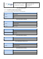
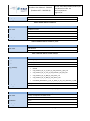
Product User Manual - PUM-25
(Product H25 – SM-OBS-4)
Doc.No: SAF/HSAF/CDOP2/PUM-25/0.7
Issue/Revision Index: 0.9
Date: 13/02/2014
Page: 1/21
EUMETSAT Satellite Application Facility on
Support to Operational Hydrology and Water Management
Product User Manual (PUM)
for product H25 – SM-OBS-4
Metop ASCAT Soil Moisture Time Series
Product User Manual - PUM-25
(Product H25 – SM-OBS-4)
Doc.No: SAF/HSAF/CDOP2/PUM-25/0.7
Issue/Revision Index: 0.9
Date: 13/02/2014
Page: 2/21
DOCUMENT CHANGE RECORD
Issue / Revision
Date
Description
Prepared by
0.1
2013/07/25
Document created.
S. Hahn
0.2
2013/09/23
Major revision of the document.
S. Hahn
0.3
2013/10/01
Updated section 3.
S. Hahn
0.4
2013/10/04
Revision of the complete document.
S. Hahn
0.5
2013/10/07
Revised document format
S. Hahn, S. Hasenauer
0.6
2013/10/16
Updated product introduction and characteristics.
S. Hasenauer
0.7
2013/10/21
Version prepared for delivery of product in
demonstrational status
Project Management Team
0.8
2014/02/07
Minor updates in section product availability
S. Hasenauer
0.9
2014/02/13
Minor changes in headlines, page breaks, links
S. Hasenauer
Product User Manual - PUM-25
(Product H25 – SM-OBS-4)
Doc.No: SAF/HSAF/CDOP2/PUM-25/0.7
Issue/Revision Index: 0.9
Date: 13/02/2014
Page: 3/21
INDEX
Introduction ........................................................................................................................................ 5
1.1
Purpose of the document ........................................................................................................... 5
1.2
Relevant staff associated to the User Service and to product SM-OBS-4 ................................. 5
2 Product description ............................................................................................................................. 6
2.1
Product parameters .................................................................................................................... 6
2.2
Product resolution and grid........................................................................................................ 7
2.3
Structure and format of the product ........................................................................................... 8
2.3.1 Data file format and file naming ........................................................................................... 8
2.3.2 NetCDF file structure .......................................................................................................... 10
2.3.3 Example NetCDF file .......................................................................................................... 14
2.4
Product change log .................................................................................................................. 15
2.5
Data Citation ............................................................................................................................ 16
3 Product validation ............................................................................................................................ 17
4 Product availability .......................................................................................................................... 17
4.1
Site ........................................................................................................................................... 17
4.2
Conditions for use .................................................................................................................... 17
5 Reference documents ....................................................................................................................... 17
6 References ........................................................................................................................................ 17
Annex 1 - Introduction to H-SAF............................................................................................................. 19
Annex 2 – Acronyms................................................................................................................................ 20
1
Product User Manual - PUM-25
(Product H25 – SM-OBS-4)
Doc.No: SAF/HSAF/CDOP2/PUM-25/0.7
Issue/Revision Index: 0.9
Date: 13/02/2014
Page: 4/21
List of Tables
Table 1: Relevant persons associated to the User service and to product SM-OBS-4 ............................... 5
Table 2 Overview of product parameters. .................................................................................................. 7
Table 3 Global NetCDF Attributes .......................................................................................................... 11
Table 4 Attribute table for variable gpi .................................................................................................... 11
Table 5 Attribute table for variable lon .................................................................................................... 11
Table 6 attribute table for variable lat ...................................................................................................... 11
Table 7 Attribute table for variable row_size ........................................................................................... 11
Table 8 Attribute table for variable jd ...................................................................................................... 11
Table 9 Attribute table for variable sm .................................................................................................... 12
Table 10 Attribute table for variable sm_noise ........................................................................................ 12
Table 11 Attribute table for variable orbit_dir ......................................................................................... 12
Table 12 Attribute table for variable proc_flag ........................................................................................ 12
Table 13 Attribute table for variable por_gldas ....................................................................................... 12
Table 14 Attribute table for variable por_hwsd ....................................................................................... 13
Table 15 Attribute table for variable ssf ................................................................................................... 13
Table 16 Attribute table for variable frozen ............................................................................................. 13
Table 17 Attribute table for variable snow............................................................................................... 13
Table 18 Attribute table for variable wetland .......................................................................................... 14
Table 19 Attribute table for variable topo ................................................................................................ 14
Table 20 Attribute table for variable doy ................................................................................................. 14
Table 21 Product change log. ................................................................................................................... 16
List of Figures
Figure 1: Screenshot of the DGG point locator.......................................................................................... 8
Figure 2: 5x5 degree cell partitioning of the grid points. The upper number in each cell represents the
cell number and the lower number the number of grid points in this cell. ............................... 9
Figure 3 An example of a NetCDF file using the software ncBrowse. The left image shows ncBrowse
after opening the NetCDF file and the right image shows all dimensions (top), attributes
(middle) and variables (bottom) in a table view. .................................................................... 14
Figure 4: Time series plot of all available variables at a grid point in Slovenia, plotted with the pytesmo
software .................................................................................................................................. 15
Figure 6 Current composition of the EUMETSAT SAF Network (in order of establishment) ............... 19
Figure 5 Conceptual scheme of the EUMETSAT Application Ground Segment .................................... 19
Product User Manual - PUM-25
(Product H25 – SM-OBS-4)
1
1.1
Doc.No: SAF/HSAF/CDOP2/PUM-25/0.7
Issue/Revision Index: 0.9
Date: 13/02/2014
Page: 5/21
Introduction
Purpose of the document
Product User Manuals are available for each (pre)-operational H-SAF product, for open users, and also
for demonstrational products, as necessary for beta-users.
Each PUM contains:
• Product introduction: principle of sensing, Satellites utilized, Instrument(s) description, Highlights
of the algorithm, Architecture of the products generation chain, Product coverage and appearance;
• Main product operational characteristics: Horizontal resolution and sampling, Observing cycle and
time sampling, Timeliness;
• Overview of the product validation activity: Validation strategy, Global statistics, Product
characterisation
• Basic information on product availability: Access modes, Description of the code, Description of the
file structure
An annex also provides common information on Objectives and products, Evolution of H-SAF
products, User service and Guide to the Products User Manual.
Although reasonably self-standing, the PUM’s rely on other documents for further details. Specifically:
• ATDD (Algorithms Theoretical Definition Document), for extensive details on the algorithms, only
highlighted here;
• PVR (Product Validation Report), for full recount of the validation activity, both the evolution and
the latest results.
These documents are structured as this PUM, i.e. one document for each product. They can be retrieved
from the CNMCA site on HSAF web page at User Documents session.
On the same site, to obtain user and password please contact the Help Desk) it is interesting to consult,
although not closely connected to this PUM, the full reporting on hydrological validation experiments
(impact studies):
• HVR (Hydrological Validation Report), spread in 10 Parts, first one on requirements, tools and
models, then 8, each one for one participating country, and a last Part with overall statements on
the impact of H-SAF products in Hydrology.
1.2
Relevant staff associated to the User Service and the product
Table 1 records the names of the persons associated to the development and operation of the User
service and of product SM-OBS-4.
Table 1: Relevant persons associated to the User service and to product SM-OBS-4
Product Development Team
Wolfgang Wagner
(Leader)
Technische Universität Wien (TU-Wien),
Stefan Hasenauer
Department of Geodesy and Geoinformation
Sebastian Hahn
Thomas Melzer
[email protected]
Austria
[email protected]
[email protected]
[email protected]
Product User Manual - PUM-25
(Product H25 – SM-OBS-4)
Christoph Paulik
Christoph Reimer
Product Operations Team
Barbara Zeiner
Zentralanstalt für Meteorologie und Geodynamik
(Leader)
(ZAMG)
2
Doc.No: SAF/HSAF/CDOP2/PUM-25/0.7
Issue/Revision Index: 0.9
Date: 13/02/2014
Page: 6/21
[email protected]
[email protected]
Austria
[email protected]
Product description
The surface soil moisture data (SSM) are retrieved from the radar backscattering coefficients measured
by the ASCAT (Advanced Scatterometer) onboard the Metop satellite (Figa-Saldaña et al. 2002) using a
change detection method, developed at the Research Group Remote Sensing, Department for Geodesy
and Geoinformation (GEO), Vienna University of Technology (TU-Wien). In the TU-Wien model,
long-term Scatterometer data are used to model the incidence angle dependency of the radar
backscattering signal. Knowing the incidence angle dependency, the backscattering coefficients are
normalised to a reference incidence angle. Finally, the relative soil moisture data ranging between 0%
and 100% are derived by scaling the normalised backscattering coefficients between the lowest/highest
values corresponding to the driest/wettest soil conditions. The derived soil moisture product represents
the content in the first 5 cm of the soil in relative units between totally dry conditions and total water
capacity. The unit is degree of saturation [%], but can be converted into volumetric units [m3m-3] with
the help of soil porosity information.
More information on the retrieval algorithm can be found in the Algorithmic Theoretical Baseline
Document (ATBD) [RD-2] and in Wagner et al. (1999) and Naeimi et al. (2009).
2.1
Product parameters
The product is composed of several parameters (geophysical parameters, flags, geo-location
information, etc.), which are described in the following Table 2.
Parameter
Description
Grid point index
The grid point index (GPI) is a unique identifier for each single grid point.
Latitude
Latitude position of the GPI in degrees.
Longitude
Longitude position of the GPI in degrees.
Row size
The number of observations per GPI is indicated by the row size or in other words
the length of the time series per GPI. A detailed description on how this is
important for reading the time series data is given in section 2.3.2.1.
Time
The time parameter represents the time stamp for the measurements. It is
defined as the days since 1970-01-01 00:00:00.
Soil moisture
Soil moisture represents the water content in the first 0-5 cm of the soil in relative
units between totally dry conditions and total water capacity. The unit is degree of
saturation [%]. A conversion from degree of saturation (%) to absolute units
(m3 m-3) is possible by using the porosity values (see equation below).
Soil moisture noise
An estimate of the uncertainty of soil moisture is given in the parameter soil
moisture noise. The unit is degree of saturation [%].
Porosity (LDAS)
The porosity is a measure of the void spaces in the soil and defined as the fraction
of the volume of voids over the total volume. The parameter is given in m3 m-3
and can be used to transform the relative soil moisture % into absolute units
m3 m-3.
Product User Manual - PUM-25
(Product H25 – SM-OBS-4)
Doc.No: SAF/HSAF/CDOP2/PUM-25/0.7
Issue/Revision Index: 0.9
Date: 13/02/2014
Page: 7/21
This parameter was resampled from the soil porosity used in the Land Data
Assimilation System (LDAS) dataset (Reynolds 2000) by NASA.
Porosity (HWSD)
See porosity description above.
This parameter was derived using soil information from the Harmonized World Soil
Database (HWSD) (FAO/IIASA/ISRIC/ISSCAS/JRC 2012) by applying the formulas
of Saxton and Rawls (2006)
Orbit direction
The orbit direction indicates the movement of the spacecraft through the plane of
reference. The ascending direction represents a movement north through the
plane of reference, and the descending south through the plane of reference.
Processing flag
The processing flags comprise information about internal quality checks and
specific processing details.
Surface state flag
The Surface State Flag (SSF) indicates the surface conditions: unknown, unfrozen,
frozen, temporary melting/water on the surface or permanent ice.
Frozen probability
This frozen probability flag is built on a historic analysis of modelled climate data
(ERA-40, Uppala et al. (2005)) and gives the probability for the frozen soil/canopy
conditions for each day of the year.
Snow probability
This snow probability flag is built on a historic analysis of SSM/I snow cover data
and gives the probability for the occurrence of snow for any day of the year.
Inundation and wetland
fraction
The fraction coverage of inundated and wetland areas are derived from a
combined analysis of the Global Lakes and Wetlands Database (GLWD) Level 3
product (2004) and the Global Self-consistent, Hierarchical, High-resolution
Shoreline database GSHHS (v1.5, 2004) which includes several wetland and
inundation types.
Topographic complexity
The topographic complexity flag is derived from the GTOPO30 data. The standard
deviation of elevation is calculated and globally normalized between 0 and 100.
Table 2 Overview of product parameters.
A conversion from degree of saturation (%) to absolute units (m3 m-3) is possible by multiplying with porosity:
s
θ=p∙
100
where θ is absolute soil moisture in m3 m-3, p is porosity in m3 m-3 and s is degree of saturation (%). As it can be seen in
this equation, the accuracy of soil porosity is as import as the relative soil moisture content.
2.2
Product resolution and grid
The spatial resolution of the product is 25x25 km and based on the WARP 5 grid [RD-1]. The WARP 5
grid represents a discrete global grid (DGG) with a grid spacing of 12.5 km. In total, there are 3264391
grid points, where 839826 are land points. The location of the points can be viewed interactively with
the internet browser tool "DGG Point Locator" (Figure 1) at the following location:
http://www.ipf.tuwien.ac.at/radar/dv/dgg
Product User Manual - PUM-25
(Product H25 – SM-OBS-4)
Doc.No: SAF/HSAF/CDOP2/PUM-25/0.7
Issue/Revision Index: 0.9
Date: 13/02/2014
Page: 8/21
Figure 1: Screenshot of the DGG point locator.
2.3
2.3.1
Structure and format of the product
Data file format and file naming
The product is provided as time series on a global discrete grid (DGG) stored in NetCDF-4. All files
follow the NetCDF Climate and Forecast (CF) Metadata Conventions version 1.6 [RD-3]. The grid
points are organised in cells, in order to reduce the number of files. The cell size is defined as 5 x 5
degree and does contain up to 2000 grid points, mainly depending on the latitude. The cell number and
the number of grid points per cell are shown in Figure 2.
Product User Manual - PUM-25
(Product H25 – SM-OBS-4)
Doc.No: SAF/HSAF/CDOP2/PUM-25/0.7
Issue/Revision Index: 0.9
Date: 13/02/2014
Page: 9/21
Figure 2: 5x5 degree cell partitioning of the grid points. The upper number in each cell represents the cell number and the
lower number the number of grid points in this cell.
A look-up containing GPI cell number, longitude and latitude can be found in this file:
TUW_WARP5_grid_info_<version>.nc
The file naming is:
TUW_METOP_ASCAT_<version><release>_<cell>.nc
A NetCDF file for cell number 234 of product version WARP5.5 R1.2 looks like this:
TUW_METOP_ASCAT_WARP55R12_0234.nc
Product User Manual - PUM-25
(Product H25 – SM-OBS-4)
2.3.2
Doc.No: SAF/HSAF/CDOP2/PUM-25/0.7
Issue/Revision Index: 0.9
Date: 13/02/2014
Page: 10/21
NetCDF file structure
2.3.2.1 Contiguous ragged array representation of time series
The time series are stored in the contiguous ragged array representation defined by the NetCDF Climate
and Forecast (CF) Metadata Conventions version 1.6 [RD-3]. The time series parameters (like soil
moisture, soil moisture noise) are associated with the coordinate values time(obs), lat(i) and lon(i),
where i indicates which time series. The time series i comprises the following data elements:
rowStart(i) to rowStart(i) + row_size(i)-1
where
rowStart(i) = 0 if i = 0
rowStart(i) = rowStart(i-1) + row_size(i-1) if i > 0
The variable row_size is the count variable containing the length of each time series feature. It is
identified by having an attribute with name sample_dimension whose value is name of the sample
dimension (obs in this case). The auxiliary coordinate variables lat and lon are GPI variables.
2.3.2.2 Global NetCDF attributes
In general the global attributes will be static and do not vary between files for the same file version
containing the same product version, with the exception of those attributes whose content is noted by a
variable (denoted as <variable>). The Global NetCDF attributes are described in Table 3.
Global Attribute Name
Content
title
Metop ASCAT Soil Moisture Time Series
institution
Vienna University of Technology
source
Metop ASCAT Level 1b 25km backscatter
Conventions
CF-1.6
product_version
<product version>
id
<filename>
date_created
<file creation date>
creator_url
http://rs.geo.tuwien.ac.at/
project
H-SAF
geospatial_lat_min
<lat min>
geospatial_lat_max
<lat max>
geospatial_lon_min
<lon min>
geospatial_lon_max
<lon max>
time_coverage_start
20070101T000000Z
time_coverage_ed
20130712T000000Z
platform
Metop-A
sensor
ASCAT
geospatial_lon_resolution
12.5 km
geospatial_lat_resolution
12.5 km
Product User Manual - PUM-25
(Product H25 – SM-OBS-4)
Doc.No: SAF/HSAF/CDOP2/PUM-25/0.7
Issue/Revision Index: 0.9
Date: 13/02/2014
Page: 11/21
Table 3 Global NetCDF Attributes
2.3.2.3 NetCDF variables and attributes
The rest of the file attributes is described in the following tables.
NetCDF Attribute
Description
long_name
Grid Point Index
cf_role
timeseries_id
coordinates
lat lon
valid_range
[0, 3264390]
Table 4 Attribute table for variable gpi
NetCDF Attribute
Description
standard_name
longitude
long_name
grid point longitude
units
degree_east
valid_range
[-180.0, 180.0]
Table 5 Attribute table for variable lon
NetCDF Attribute
Description
standard_name
latitude
long_name
grid point latitude
units
degree_north
valid_range
[-90.0, 90.0]
Table 6 attribute table for variable lat
NetCDF Attribute
Description
sample_dimension
obs
long_name
Number of observations for this grid point
Table 7 Attribute table for variable row_size
NetCDF Attribute
Description
standard_name
Time
long_name
Time of measurement
coordinates
time lat lon
Table 8 Attribute table for variable jd
NetCDF Attribute
Description
long_name
Soil Moisture
units
%
coordinates
time lat lon
Product User Manual - PUM-25
(Product H25 – SM-OBS-4)
valid_range
[0, 100]
missing_value
-1
Doc.No: SAF/HSAF/CDOP2/PUM-25/0.7
Issue/Revision Index: 0.9
Date: 13/02/2014
Page: 12/21
Table 9 Attribute table for variable sm
NetCDF Attribute
Description
long_name
Soil Moisture Noise
units
%
coordinates
time lat lon
valid_range
[0, 100]
missing_value
-1
Table 10 Attribute table for variable sm_noise
NetCDF Attribute
Description
long_name
Orbit direction
coordinates
time lat lon
Table 11 Attribute table for variable orbit_dir
NetCDF Attribute
Description
long_name
Processing flag
flag_values
0, 1, 2, 4, 8, 16
coordinates
time lat lon
flag_meanings
•
default
•
soil_moisture_set_to_0_since_it_was_between_0_and_-50
•
soil_moisture_set_to_100_it_was_between_100_and_150
•
soil_moisture_set_to_NaN_it_was_below_-50
•
soil_moisture_set_to_NaN_it_was_above_150
•
normalised_backscatter_is_out_of_limits_or_dry_wet_reference_is_NaN
valid_range
[0, 16]
missing_value
-1
Table 12 Attribute table for variable proc_flag
NetCDF Attribute
Description
long_name
Porosity resampled from NASA’s LDAS
units
m3 m-3
coordinates
lat lon
valid_range
[0, 1]
missing_value
-1
Table 13 Attribute table for variable por_gldas
Product User Manual - PUM-25
(Product H25 – SM-OBS-4)
NetCDF Attribute
Doc.No: SAF/HSAF/CDOP2/PUM-25/0.7
Issue/Revision Index: 0.9
Date: 13/02/2014
Page: 13/21
Description
long_name
Porosity derived from HWSD
units
m3 m-3
coordinates
lat lon
valid_range
[0, 1]
missing_value
-1
Table 14 Attribute table for variable por_hwsd
NetCDF Attribute
Description
long_name
Surface State Flag
flag_values
0, 1, 2, 3, 4
coordinates
time lat lon
flag_meanings
•
unknown
•
unfrozen
•
frozen_temporary
•
melting_water_on_the_surface
•
permanent_ice
valid_range
[0, 4]
missing_value
-1
Table 15 Attribute table for variable ssf
NetCDF Attribute
Description
long_name
Frozen probability
units
%
coordinates
doy lat lon
valid_range
[0, 100]
missing_value
-1
Table 16 Attribute table for variable frozen
NetCDF Attribute
Description
long_name
Snow probability
units
%
coordinates
doy lat lon
valid_range
[0, 100]
missing_value
-1
Table 17 Attribute table for variable snow
NetCDF Attribute
long_name
Description
Inundation and wetland fraction
Product User Manual - PUM-25
(Product H25 – SM-OBS-4)
units
%
coordinates
lat lon
valid_range
[0, 100]
missing_value
-1
Doc.No: SAF/HSAF/CDOP2/PUM-25/0.7
Issue/Revision Index: 0.9
Date: 13/02/2014
Page: 14/21
Table 18 Attribute table for variable wetland
NetCDF Attribute
Description
long_name
Topographic complexity
units
%
coordinates
lat lon
valid_range
[0, 100]
missing_value
-1
Table 19 Attribute table for variable topo
NetCDF Attribute
Description
long_name
Day of year
units
days
Table 20 Attribute table for variable doy
2.3.3
Example NetCDF file
An example of the NetCDF product is shown in the following Figure 3. The viewer used for this
example is ncBrowse, available at:
http://www.epic.noaa.gov/java/ncBrowse/
Figure 3 An example of a NetCDF file using the software ncBrowse. The left image shows ncBrowse after opening the
NetCDF file and the right image shows all dimensions (top), attributes (middle) and variables (bottom) in a table view.
Product User Manual - PUM-25
(Product H25 – SM-OBS-4)
Doc.No: SAF/HSAF/CDOP2/PUM-25/0.7
Issue/Revision Index: 0.9
Date: 13/02/2014
Page: 15/21
The netCDF files can also be easily read using the open source python package pytesmo (Toolbox for
the Evaluation of Soil Moisture Observations). For more information (installation instructions,
documentation, examples and links to the source code) please consult the pytesmo website at:
http://rs.geo.tuwien.ac.at/validation_tool/pytesmo/.
After Downloading the NetCDF files as well as the grid information NetCDF file to your computer the
data can be read with pytesmo and plotted with the matplotlib library using the following example
program. The output time series plot is shown in Figure 4.
import matplotlib.pyplot as plt
import pytesmo.io.sat.ascat as ascat
import os
ascat_folder = os.path.join(‘path’,’to’,’downloaded’,’NetCDF’,’files’)
# path to which you downloaded the NetCDF files
ascat_grid_folder = os.path.join(‘path’,’to’,’grid’,’NetCDF’,’file’)
#path to the grid file TUW_warp5_grid_info_<version>.nc
ascat_SSM_reader = ascat.AscatH25_SSM(ascat_folder, ascat_grid_folder)
gpi = 2329253
result = ascat_SSM_reader.read_ssm(gpi)
#alternative way using lon, lat
#lon = 14.284
#lat = 45.698
#result = ascat_SSM_reader.read_ssm(lon, lat)
result.plot()
plt.show()
Figure 4: Time series plot of all available variables at a grid point in Slovenia, plotted with the pytesmo software
2.4
Product change log
The following Table 21 lists the product changes with the most recent version on top.
Product
version/release
WARP5.5 R1.2
Description
Extension of time-series 2013-03-01 to 201307-12
Processed: Sep 2013
Algorithm changes
Product User Manual - PUM-25
(Product H25 – SM-OBS-4)
WARP5.5 R1.1
WARP5.5 R0.1
WARP5.4 R2.2
WARP5.4 R2.1
Reprocessing 2007-01-01 to 2013-02-28
Processed: Mar 2013
Reprocessing 2007-01-01 to 2012-11-30
Processed: Dec 2012 – Jan 2013
Extension of time-series 2011-12-31 to 201205-31
Processed: Jun 2012
Reprocessing 2007-01-01 to 2011-12-31
Processed: Feb 2012
Doc.No: SAF/HSAF/CDOP2/PUM-25/0.7
Issue/Revision Index: 0.9
Date: 13/02/2014
Page: 16/21
Inter-beam calibration of Level 1 backscatter
data applied.
The criterion for a successful fit to the
logistic
function
during
freeze-thaw
computation turned out to be too strict,
resulting in many invalid SSFs, particularly in
the northern regions. The criterion has been
relaxed.
WARP5.4 R1.4
WARP5.4 R1.3
WARP5.4 R1.2
WARP5.4 R1.1
WARP5.4 R0.1
Extension of time-series (2007-01-01 to 201112-31)
Processed: Jan 2012
Extension of time-series 2011-06-11 to 201108-17
Processed: Nov 2011
Extension of time-series 2010-12-31 to 201106-11
Processed: Nov 2011
Reprocessing 2007-01-01 to 2010-12-31
Processed: Nov 2011
Correction of SSF computation.
Reprocessing 2007-01-01 to 2010-12-31
Processed: May – Jun 2011
Table 21 Product change log.
2.5
Data Citation
The data set should be cited using the complete references as follows:
[1] W. Wagner, G. Lemoine, and H. Rott, “A method for estimating soil moisture from ERS
scatterometer and soil data,” Remote Sensing of Environment, vol. 70, no. 2, pp. 191–207, 1999.
[2] V. Naeimi, K. Scipal, Z. Bartalis, S. Hasenauer, and W. Wagner, “An Improved Soil Moisture
Retrieval Algorithm for ERS and METOP Scatterometer Observations,” IEEE Trans. Geosci. Remote
Sensing, vol. 47, no. 7, pp. 1999–2013, 2009.
[3] V. Naeimi, C. Paulik, A. Bartsch, W. Wagner, R. Kidd, S.-E. Park, K. Elger, and J. Boike, “ASCAT
Surface State Flag (SSF): Extracting Information on Surface Freeze/Thaw Conditions From Backscatter
Data Using an Empirical Threshold-Analysis Algorithm,” IEEE Transactions on Geoscience and
Remote Sensing, 2012.
[4] Naeimi, V., Paulik, C., Bartsch, A., Wagner, W., Kidd, R., Park, S.-E., Elger, K., Boike, J. (2012).
ASCAT Surface State Flag (SSF): Extracting Information on Surface Freeze/Thaw Conditions From
Backscatter Data Using an Empirical Threshold-Analysis Algorithm. IEEE Transactions on Geoscience
and Remote Sensing, 50(7), 2566–2582. doi:10.1109/TGRS.2011.2177667
Product User Manual - PUM-25
(Product H25 – SM-OBS-4)
3
Doc.No: SAF/HSAF/CDOP2/PUM-25/0.7
Issue/Revision Index: 0.9
Date: 13/02/2014
Page: 17/21
Product validation
Detailed information about product validation can be found in the corresponding Algorithmic
Theoretical Baseline Document (ATBD) [RD-2].
4
4.1
Product availability
Site
The product is available via FTP. Login details are available after contacting the user help desk at
http://hsaf.meteoam.it/
4.2
Conditions for use
All H-SAF products are owned by EUMETSAT, and the EUMETSAT SAF Data Policy applies. They
are available for all users free of charge.
Users should recognise the respective roles of EUMETSAT, the H-SAF Leading Entity and the H-SAF
Consortium when publishing results that are based on H-SAF products. EUMETSAT’s ownership and
intellectual property rights into the SAF data and products is best safeguarded by simply displaying the
words “© EUMETSAT” under each of the SAF data and products shown in a publication or website.
5
Reference documents
[RD-1] WARP 5 grid document, version 0.3, 4 October 2013, Vienna University of Technology,
Austria
[RD-2] Algorithm Theoretical Baseline Document (ATBD) for product H25/SM-OBS-4 METOP
ASCAT Soil Moisture Time Series, version 0.3, 16 October 2013
[RD-3] NetCDF Climate and Forecast (CF) Metadata Conventions: Version 1.6, 5 December, 2011,
Brian Eaton, Jonathan Gregory, Bob Drach, Karl Taylor, and Steve Hankin
6
References
FAO/IIASA/ISRIC/ISSCAS/JRC (2012). Harmonized World Soil Database (version 1.2)
Figa-Saldaña, J., Wilson, J.J.W., Attema, E., Gelsthorpe, R., Drinkwater, M.R., & Stoffelen, A. (2002).
The advanced scatterometer (ASCAT) on the meteorological operational (MetOp) platform: A
follow on for European wind scatterometers. Canadian Journal of Remote Sensing, 28, 404-412
Naeimi, V., Scipal, K., Bartalis, Z., Hasenauer, S., & Wagner, W. (2009). An improved soil moisture
retrieval algorithm for ERS and METOP scatterometer observations. IEEE Transaction on
Geoscience and Remote Sensing, 47, 1999-2013
Reynolds, C.A., T. J. Jackson, and W. J. Rawls ( 2000). Estimating soil water-holding capacities by
linking the Food and Agriculture Organization soil map of the world with global pedon
databases and continuous pedotransfer functions. Water Resour. Res., 36, 9
Product User Manual - PUM-25
(Product H25 – SM-OBS-4)
Doc.No: SAF/HSAF/CDOP2/PUM-25/0.7
Issue/Revision Index: 0.9
Date: 13/02/2014
Page: 18/21
Saxton, K.E., & Rawls, W.J. (2006). Soil Water Characteristic Estimates by Texture and Organic Matter
for Hydrologic Solutions. Soil Science Society of America Journal, 70, 1569
Uppala, S.M., Kallberg, P.W., Simmons, A.J., Andrae, U., Bechtold, V.D., Fiorino, M., Gibson, J.K.,
Haseler, J., Hernandez, A., Kelly, G.A., Li, X., Onogi, K., Saarinen, S., Sokka, N., Allan, R.P.,
Andersson, E., Arpe, K., Balmaseda, M.A., Beljaars, A.C.M., Van De Berg, L., Bidlot, J.,
Bormann, N., Caires, S., Chevallier, F., Dethof, A., Dragosavac, M., Fisher, M., Fuentes, M.,
Hagemann, S., Holm, E., Hoskins, B.J., Isaksen, L., Janssen, P., Jenne, R., McNally, A.P.,
Mahfouf, J.F., Morcrette, J.J., Rayner, N.A., Saunders, R.W., Simon, P., Sterl, A., Trenberth,
K.E., Untch, A., Vasiljevic, D., Viterbo, P., & Woollen, J. (2005). The ERA-40 re-analysis.
Quarterly Journal of the Royal Meteorological Society, 131, 2961-3012
Wagner, W., Lemoine, G., & Rott, H. (1999). A Method for Estimating Soil Moisture from ERS
Scatterometer and Soil Data. Remote Sensing of Environment, 70, 191-207
Product User Manual - PUM-25
(Product H25 – SM-OBS-4)
Doc.No: SAF/HSAF/CDOP2/PUM-25/0.7
Issue/Revision Index: 0.9
Date: 13/02/2014
Page: 19/21
Annex 1 - Introduction to H-SAF
The EUMETSAT Satellite Application Facilities
H-SAF is part of the distributed application ground segment of the “European Organisation for the
Exploitation of Meteorological Satellites (EUMETSAT)”. The application ground segment consists of a
“Central Application Facility (CAF)” and a network of eight “Satellite Application Facilities (SAFs)”
dedicated to development and operational activities to provide satellite-derived data to support specific
user communities. See next figure:
EUM Geostationary
Systems
Systems of the
EUM/NOAA
Cooperation
Data Acquisition
and Control
Data Processing
EUMETSAT HQ
other data
sources
Application Ground Segment
Meteorological Products
Extraction
EUMETSAT HQ
Archive & Retrieval
Facility (Data Centre)
EUMETSAT HQ
Centralised processing
and generation of products
Satellite Application
Facilities (SAFs)
Decentralised processing
and generation of products
USERS
Figure 5 Conceptual scheme of the EUMETSAT Application Ground Segment
Next figure reminds the current composition of the EUMETSAT SAF network (in order of
establishment).
Nowcasting & Very
Short Range Forecasting
Ocean and Sea Ice
Ozone & Atmospheric
Chemistry Monitoring
Climate Monitoring
Numerical Weather
Prediction
GRAS Meteorology
Land Surface Analysis
Operational Hydrology
& Water Management
Figure 6 Current composition of the EUMETSAT SAF Network (in order of establishment)
H-SAF objectives and products
The H-SAF was established by the EUMETSAT Council on 3 July 2005; its Development Phase started
on 1st September 2005 and ended on 31 August 2010. Its first Continuous Development and Operations
Phase (CDOP) started on 28 September 2010 and ended on 28 February 2012. The SAF is now in its
Second Continuous Development and Operations Phase (CDOP-2) started on 1 March 2012 and will
end on 28 February 2017.
Product User Manual - PUM-25
(Product H25 – SM-OBS-4)
Doc.No: SAF/HSAF/CDOP2/PUM-25/0.7
Issue/Revision Index: 0.9
Date: 13/02/2014
Page: 20/21
The H-SAF objectives are:
a. to provide new satellite-derived products from existing and future satellites with sufficient time and
space resolution to satisfy the needs of operational hydrology; identified products:
• precipitation;
• soil moisture;
• snow parameters;
b. to perform independent validation of the usefulness of the new products for fighting against
floods, landslides, avalanches, and evaluating water resources; the activity includes:
• downscaling/upscaling modelling from observed/predicted fields to basin level;
• fusion of satellite-derived measurements with data from radar and raingauge networks;
• assimilation of satellite-derived products in hydrological models;
• assessment of the impact of the new satellite-derived products on hydrological applications.
Annex 2 – Acronyms
ASAR
ASAR
ASCAT
ATDD
AU
BfG
BUFR
CAF
CC
CDA
CESBIO
CM-SAF
CNMCA
CNR
CNRS
CORINE
DPC
DWD
EARS
ECMWF
Envisat
ESA
EUM
EUMETCast
EUMETSAT
FMI
FTP
GEO
GMES
GRAS-SAF
H-SAF
IFOV
IMWM
IR
IRM
ISAC
ITU
LATMOS
Advanced Synthetic Aperture Radar (on Envisat)
GM ASAR Global Mode
Advanced Scatterometer (on MetOp)
Algorithms Theoretical Definition Document
Anadolu University (in Turkey)
Bundesanstalt für Gewässerkunde (in Germany)
Binary Universal Form for the Representation of meteorological data
Central Application Facility (of EUMETSAT)
Correlation Coefficient
Command and Data Acquisition station
Centre d'Etudes Spatiales de la BIOsphere (of CNRS, in France)
SAF on Climate Monitoring
Centro Nazionale di Meteorologia e Climatologia Aeronautica (in Italy)
Consiglio Nazionale delle Ricerche (of Italy)
Centre Nationale de la Recherche Scientifique (of France)
COoRdination of INformation on the Environment
Dipartimento Protezione Civile (of Italy)
Deutscher Wetterdienst
EUMETSAT Advanced Retransmission Service
European Centre for Medium-range Weather Forecasts
Environmental Satellite
European Space Agency
Short for EUMETSAT
EUMETSAT’s Broadcast System for Environmental Data
European Organisation for the Exploitation of Meteorological Satellites
Finnish Meteorological Institute
File Transfer Protocol
Geostationary Earth Orbit
Global Monitoring for Environment and Security
SAF on GRAS Meteorology
SAF on Support to Operational Hydrology and Water Management
Instantaneous Field Of View
Institute of Meteorology and Water Management (in Poland)
Infra Red
Institut Royal Météorologique (of Belgium) (alternative of RMI)
Istituto di Scienze dell’Atmosfera e del Clima (of CNR, Italy)
İstanbul Technical University (in Turkey)
Laboratoire Atmosphères, Milieux, Observations Spatiales (of CNRS, in France)
Product User Manual - PUM-25
(Product H25 – SM-OBS-4)
LEO
LSA-SAF
LST
ME
Météo France
MetOp
METU
MTF
MW
NMA
NOAA
NWC
NWC-SAF
NWP
NWP-SAF
O3M-SAF
OMSZ
ORR
OSI-SAF
Pixel
PNG
PUM
PVR
REP-3
RMI
RMSE
SAF
SAR
SD
SHMÚ
SYKE
TKK
TSMS
TU-Wien
UniFe
URL
UTC
VIS
WARP-H
ZAMG
Doc.No: SAF/HSAF/CDOP2/PUM-25/0.7
Issue/Revision Index: 0.9
Date: 13/02/2014
Page: 21/21
Low Earth Orbit
SAF on Land Surface Analysis
Local Solar Time (of a sunsynchronous orbit)
Mean Error
National Meteorological Service of France
Meteorological Operational satellite
Middle East Technical University (in Turkey)
Modulation Transfer Function
Micro Wave
National Meteorological Administration (of Romania)
National Oceanic and Atmospheric Administration (Agency and satellite)
Nowcasting
SAF in support to Nowcasting & Very Short Range Forecasting
Numerical Weather Prediction
SAF on Numerical Weather Prediction
SAF on Ozone and Atmospheric Chemistry Monitoring
Hungarian Meteorological Service
Operations Readiness Review
SAF on Ocean and Sea Ice
Picture element
Portable Network Graphics
Product User Manual
Product Validation Report
H-SAF Products Valiadation Report
Royal Meteorological Institute (of Belgium) (alternative of IRM)
Root Mean Square Error
Satellite Application Facility
Synthetic Aperture Radar
Standard Deviation
Slovak Hydro-Meteorological Institute
Suomen ympäristökeskus (Finnish Environment Institute)
Teknillinen korkeakoulu (Helsinki University of Technology)
Turkish State Meteorological Service
Technische Universität Wien (in Austria)
University of Ferrara (in Italy)
Uniform Resource Locator
Universal Coordinated Time
Visible
WAter Retrieval Package for hydrologic applications
Zentralanstalt für Meteorologie und Geodynamik (of Austria)