1
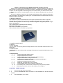
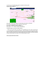
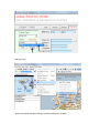
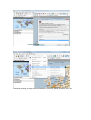
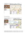
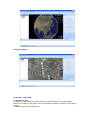
GPS/GSM/GPRS PERSONAL TRACKING SYSTEM USER MANUAL MODEL GP2500M CHAPTER1 GP2500M INTRODUCTION OF THE GPSTRACKING SYSTEM……………………… 1.1 COMPONENT………………………………………………………………………………… 1.2 FUNCTIONS & CHARACTERISTIC……………………………………………………… CHAPTER2 START GP2500M…………………………………………………………………… CHAPTER3 GP2500C PERSONAL TRACKING SYSTEM INSTALLATION & OPERATION………… 2.1 PREPARE……………………………………………………………………………… 2.2 LOCATION AND TRACKING SERVICE……………………………………………………… 2.3 CRY FOR HELP……………………………………………………………………………… 2.4 MOVING DETECTION……………………………………………………………………… 2.5 SPEEDING ALARM FUNCTION……………………………………………………………… 2.6 POWER LOWER NOTE……………………………………………………………………… 2.7 HOW TO GET THE LAST POSITION WHEN NO GPS SIGANL…………………………………… CHAPTER4 REMARK & OTHERS…………………………………………………………………… 3.1 ANNOUNCEMENTS……………………………………………………………………… 3.2 MAINTENANCE…………………………………………………………………………… 3.3 SERVICE ITEMS CHAPTER5 FAQ………………………………………………………………………… CHAPTER6 HOW TO USE USB TO RS232 DATA CABLE …………………………………………… CHAPTER7 GP2500M SHORT MESSAGE COMMAND …………………………………… Chapter 1 introduction of the GP2500 tracking & navigation system Thank you for choosing the GP2500M tracking system, To get the most from you new GPS, take the time to read through the user manual in order to understand the operation features of the GPS. You are supposed to read through the user manual when you start to use the GPS. To get better service, it maybe helpful to fill out the warrant carefully when you buy our products. We won’t in addition to inform you the changes with the latest driver related to the product and the content in this instruction. Please go to our website below to download the driver and latest news about the product. 1.1 System component* The hardware consists of GP2500M main board (and GP2500C SMS modem is optional) The software is GP2500 tracking & navigation system (GP2500C hardware is needed) GP2500 Tracking system can driver any standard navigation map system(include Google Earth & MS Mapoint) The accessories in the package are as following: Power 5V charger 1pcs Data cable for GP2500C 1pcs optional USB to RS232 Cable for GP2500C 1pcs optional 1. POWER CHARGE INPUT 2. ON/OFF 3. SOS1 BUTTON “Cry For Help!” and current position message will be send to bounded mobile Number. when press down 4. SOS2 BUTTON “Call The Police!” and current position message will be send to bounded mobile Number. when press down 1.2 Characteristic 1. 1. Support GPS/GSM double location 2. 2. Support GPRS/Internet location 3. 3. Support GPRS auto reconnection when GPRS breaking 4. 4. Support GSM/GPRS working mode switch 5. 5. Support short message command and remote set parameters 6. 6. All parameters can be auto saved 7. 7. Support auto sleep and power saved 8. 8. Small size.: full group size is only 7*5*2cm. 9. 9. Support NMEA 0183 protocol upload to GPRS server 10. 10. Free monthly rent, Point-to-Point, Point-to-troop ,troop-to-troop monitor 11. 11. Multi-functions: locate, monitor, real tracking, cry for help etc. CHAPTER2 START GP2500M. 1. 1. Insert a new SIM card to GP2500M 2. 2. Turn on GP2500M and wait for 3 minutes, so that GP2500M can start and test-self finished 3. 3. Call GP2500M by your mobile 4. 4. If GP2500M is fixed then GP2500M will send the position message to mobile which is calling For example: you’ll receive a message as below: $GPRMC,092313.299,A,2238.8947,N,11355.2253,E,0.00,311.19,010307,,,A*68 Means is: UTC Time: 09:23 13.299 (A) Data is valid Latitude: 22°38.8947″,North Longitude: 113°55.2253″,East Speed: 0.00 (sea mile) 1mile=1852meter Course: 311.19 Date: 01032007 Checksum: *68 5. 5. You can input this message data to google earth or other any map system, so that you can view the position on the map system directly CHAPTER3 GP2500C PERSONAL TRACKING SYSTEM INSTALLATION AND OPERATIONS. 3.1 preparations (initialize your SIM card) Before you use the GPS, it’s better to buy two new SIM card for back up, and initialize them after the installation of the GP2500 tracking &navigation and geography information system operate. For Example: Card1 is Central No., Card2 is User id (in GP2500M No.) Steps: 1). insert card2 into the GP2500C 2). Connect GP2500C to PC RS-232 port (if your computer doesn’t have the port, take the USB serial bus instead, you could obtain more details about the installation of the USB serial bus in CHAPTER6) 3). Turn on the power of GP2500C 4). Browse the GP2500 tracking and navigation system (see below) 5). Setup the proper port No which usually is COM1 or COM2.and select 9600 as the network velocity. (Remark: if you connect the port with the USB serial bus, please set up the GPS port No according to CHAPTER6 ) 6). Click on initial GP2500M in system menu (see below) 7). Input the Center No. (Card1 No.) Master ID (Yours Mobile No.) New password, the new password is 4 random number for standby. If you not use GPRS function, Please do not select GPRS option and needn’t input GPRS parameters. 8). Click on the <Confirm> button to write parameters, It takes 30 seconds to write parameters, You can’t click mouse or press any key on the keyboard until write finished. if you fail, please repeat the foregoing steps. 9).If finished, please operate on messages. 10). Take out the card2 from the GP2500C and insert it into the GP2500M 11). Insert card1 into the GP2500C 12). Initialization finished 13). The GP2500M mainframe after turn on power startup process need about 3 minutes then you can natural use it. 3.2 Locate & tracking service You can use the any geography information system to locate and track your targets without any rent. Steps: 1). Install the GP2500M in your vehicle, fleet and other targets. 2). Turn on the GP2500M, 3minutes later, use you mobile phone to dial the GP2500M to verify the main frame starts up or not. Hang up automatically represents the well running of the system; otherwise, you should repeat the initialization. 3). Connect GP2500C to PC RS-232 port (if your computer doesn’t have the port, take the USB serial bus instead, you could obtain more details about the installation of the USB serial bus in the CHAPTER6) 4). Browse the GP2500 tracking system 5). Setup the proper COM port of GPS, which usually are COM1 or COM2. Remark: if you connect the port with the USB serial bus, please set up the GPS port No according to CHAPTER6 6). Click on <Tracking> or <Send command> button to start tracking. 7). If you click <Send command> then the command input window will be showed (see below) 8). Select the terminal No for mobile No. then click <Add to Send list> 9). Select the tracking counter and interval 10). Input the password 11). Press<ok> button to send command 12). you can also modify central No., password, and Master ID in this window 15).Please keep the <Auto show> button is press down 16). Browse the geography information system 17). Setup the conjunction as COM6, baud is 9600 18). Confirm OK 19). Now you can tracking and monitor you target in the map system 20).You wonder” where is your car?” 21).Don’t worry, Here it is! 22). Click on <back view> button to view the history trace which you selected. 23). Click on <clear history> button to erase the history trace 24) .Click on <speed up> button to speed up 25). Click on <speed down> button to speed down 26). Click on “<” or “>” button to switch review direction 3.4 Call the police and Cry for help functions There are two button(SOS1 and SOS2) on the GP2500M, which are used to call the police or cry for help,When you press these buttons, a alarm message and a fixed position will be sent to the system, and at the same time, the system will warn of danger by means of sound or music. The function works only you keep pressing at least one second to avoid the accidental touching. Warning alarm will continue if you hold pressing the buttons. Select people and start to track. Start the map: Search and select the right COM port (Default COM port is COM6). Real time tracking on map current information of vehicle, speed, direction, time, etc Create GPS tracking trail 3.5 Moving detection function(Reference GP2500M Short Message command: *GP004X) 3.6 Over speed Alarm function(Reference GP2500M Short Message command: *GP007X) 3.7 Exterior power cut and lower voltage information When exterior power cut and lower voltage, the equipment will raise the alarm to bounded mobile number(Master ID) 3.8 To get the last position when no GPS signal When the car is stolen and hidden or no GPS single, you can still click on <get last position> button which on the main screen to get the last fixed position. Your can also send a SMS command to the GP2500M and get the last fixed position 3.9. Use the new EX300 PC based stand alone tracking software ( new) The EX300 is a standalone GPS tracking software solution, supporting ExtremTrac vehicle tracker GP2500T and personal tracker GP2500M. This software works with Microsoft MapPoint 2004/2006, Online Google maps, Free Google Earth, Google Earth plus, Mapinof, as well as most navigation maps (PC version). GP2500T/M communicates both by GPRS and SMS. When using the GPRS communication mode, we offer the system communication protocol, so that users can integrate GP2500T/GP2500M with their own server software. If track by SMS, a GSM modem GP2500C is required, the software uses the RS232 serial port to communicate data by SMS, ( or by RS232-USB adaptor cable if uses the laptop ). In this solution, users no need the expensive server platfram, no month fee occured. EX300 can track unlimited vehicles/people, and allow tracking pultiple targets in one time. It has onscreen vehicle control like cut oil or power. 3. How it works in standalone solution by SMS: GP2500T/M trackers get GPS data and send this information to the GSM modem by cellular network. The GSM modem is connected with PC, laptop, it collects all data by SMS, so this complete system can run without internet, yet it is real time. The data that collected via the GSM model will forward to the EX300 in PC and show onscreen map all tracking details. On the EX300 software interface, monitoring people can also send command to the vehicles to control vehicles. GP2500T/M can also be tracked by mobile phone for double security protection, and users can send command to control vehicles as well. The new tracking software EX300 works with ExtremTrac GPS/GPRS/GSM vehicle tracker and GPS/GPRS/GSM personal tracker, this software support online Google map, free Google Earth map, MS mappoint map. It has added a number of new features to the software, including more vehicle control options and an alarm alert interface with a pop-up notification for car owners. Users can also now switch maps with the press of a single button. This software is particularly useful in countries beyond the United States and Europe where detailed street-level maps might not be readily available, Like Brazil, Malaysia, Indonisia, India, Thailand, Philippine, Japan, Kenya, Puerto Rico, Haiti,important areas of Australia, chile, Ecuador, Colombia, venezuela, Trinidad Tobago, Costa Rica Nicaragua, Hunduras, El Salvador, Guatemala, Mexico, important areas of Canada, Russia, Turkey, important areas of Iran and Pakistan, United Arab Emirates, important areas of Egypt, important areas of Morocco, important areas of South Africa, etc Start Tracking and select maps: Track by online Google maps Track by Google Earth map. History play back: CHAPTER4 CAUTIONS. 4.1 Announcements All data is from the military GPS that is operated by the government of the United States. We have no liability for the system and communication malfunction caused by the following reasons: 1. Satellite communication malfunction. 2. Atrocious weather. 3. Other force majeure e.g. war, earthquake and natural disaster. 4.2 Maintenance 1. Be sure to use the data cable recommended by us to connect to the input properly, not allow to instead by unauthoritative data cable, and we won’t repair the damages caused by the unapproved data cable. 2. Do not expose the GPS system to rain. The equipment should be put in a vent place when it’s caught in the rain. Do not move the equipment from a zero degrees cold place to a hot place, Try the power on and allow a certain time to dry the condensation accrued inside. 3. When the GPS system malfunction accrues, be dropped or moist, you should not unpack it, which will cause harmful interference to the parts. GPS system is quite different with home appliances; you are not able to fix it without professional knowledge. Consult to our appointed dealer if the maintenance man could not repair. 4.3 Service terms 1. The warrant shall be effective as of the purchasing date written in the warrant. 2. We offer free maintenance to the damages caused by the quality, the user could lose the authority to repair the equipment if an unauthoritative changes or modification is made. The situations below will void the user’s right of repair: 1) Alter the content of the warrant or fill out irrelevant information. 2) Personal damage or do not operate normally by following the instruction. 3) Repair or split the GPS without the approval. 4) PCB damaged or severe damage of the crust. 5) Overdue. 6) Accessories except the mainframe (e.g. disc, instruction, charger and connector etc). 7) The period of maintenance will not be prolong or start again when your GPS system mend. 8) We won’t responsible for the unexpected, special or indirect lose for the users and dealers. 3. If the instruction and disc are missing, please go to our website below to download 4. We won’t in addition to inform you the changes with the latest driver related to the product and the content in this instruction. Please go to our website below to download the driver and latest news about the product. 5. Reserve the right of all the warrant clauses. CHAPTER5 F.A.Q. 1. What’s the component of the GPS tracking & navigation system? A:The hardware consists of GP2500M main board + GP2500C controller(optional) The software consists of GP2500 tracking & navigation software+ geography information system GPS tracking & navigation system consists of these two parts, and the GP2500M is considered as the mainframe, which is usually installed in the remote terminal system need to be tracked and monitor, e.g. airplane, train, vehicle, fleet, large-scale construct measurement, accurate real time, motion base orientation etc. Besides, the accessories in the package are as following: Power cable of mainframe 1pcs and DC supply voltage 5V/1A Li-ion battery 1 pcs GP2500C personal system is optional (include GP2500C,data cable, software etc.) 2. What’s the function and special purpose of the GP2500 system? A:GP2500 system concentrates the functions of satellite locate, tracking, orientation, antitheft monitor, emergent alarm and cry for help, and it is widely used for military measurement, large-scale construct measurement, accurate real time, motion base orientation, tailor-made timer and other high-tech peculiar field. 3. What’s the difference of GP2500M and GP2500C? A:We should combine GP2500M and GP2500C to realize the tracking function of Point-to-Point monitor, Point-to-troop monitor, troop-to-troop monitor. GP2500M is considered as the mainframe, which is usually installed in the remote terminal system need to be tracked. E.g. airplane, train, vehicle, fleet, large-scale construct measurement, accurate real time, motion base orientation etc. GP2500C is considered as the controller; we usually put it at home or safety places and used to locate GP2500M quickly 4. Is it normal that the phone always hands up when we dial to the terminal no of the GP2500M? A:When you dial to GP2500M terminal, it will automatically hand up, which shows the GP2500Mworks well. This operator can test whether the GP2500M is working well, besides, if the GP2500M is fixed, then GP2500M will send the current position to central No. 5. Why display time in the GPS SEVER is so difference from the local time when I operate the real-time tracking function to the GP2500C terminal? A:The GPS SEVER displays the world standard time, i.e. the GMT, then you can adjust the time by plus or minus the time-zone in your location, e.g. if you are in Peking, HK, or Urumchi, you can change the time by adding 8 hours to the GMT. 6. Why sometimes it shows error between the translational speed and actual speed in the map? A:The GP2500M will bring transitory floating speed for the first tracking, which will go way when it becomes stable. If you find the error is rather big, then you should examine the probability of diversion speed in the map system. The unit in the NMEA protocol is nm, some map system displays in km, some shows in nm, 1nm=1.852km. CHAPTER6 HOW TO USE USB TO RS232 DATA CABLE 1. Connect the two pots of the USB serial bus to the computer USB port and GP2500 system data wire separately; put the matched disc into the CD-ROM when the computer prompts "new hardware detective”, and install the driver by the cues. 2. Click <my computer>, select<attribute>, and view the port No in the <port> submenu of the <equipment administration>, set the port No as the “GPS port” in the GP2500 system. 3. After that, you can use the USB serial bus. But we would remind you, the new port no would be changed when you pull in or out the USB serial bus. Therefore, you should be better reset the port No according to the foregoing steps. Cautions The communication will be unstable or fail when you connect the system by the RS-232 serial bus. The reason is possibly because the USB universal serial bus is used by other equipments at the same time, but it won’t interfere the running. You can pull out the USB to settle this problem, in case failing again, you can consider resetting the drive or replacing the USB serial bus. If you computer has the RS-232 port, we suggest you to connect the system using a common serial bus, if you insist using the USB serial bus, we advice you use the recommended USB serial bus to guarantee the communication quality. CHAPTER7 GP2500M SHORT MESSAGE COMMAND GP2500M(M) TRACKING&NAVIGATION SYSTEM CONTROLLER (GPS/GSM/GPRS) Syntax contract: Start 5 bytes is command header <****> is operate password (only 4 digital) 1. 1. *GP001 Function: SET CENTRAL No. COMMAND Syntax: *GP001<Cent.No.>,<Password> Return: Set CentNo. OK Parameters: <Cent.No>. Set new host Central No. <Password> Command password For example: *GP00113632685163,0000 Comment: *GP001 is command header, red text is new host central No. 2. 2. *GP002 Function: MODIFY PASSWORD COMMAND Syntax: *GP002<New Password.>,<Password> Return: Set Password. OK Parameters: <New Password>. Set new Password <Password> Command password For example: *GP0028888,0000 Comment: 8888 is new password,0000 is old command password 3. 3. *GP003 Function: Active Tracking command Syntax: *GP003<,Active mode>,<Counter>,<Interval>,<Password> Return: NMEA $GPRMC DATA Parameters: <Active mode> Set Active mode Only be format: <1001> or <0001> or <1000> or <0000> <1111>Ect. <Counter> Set return NMEA $GPRMC DATA record counter <Interval> Set return interval <Password> Command password For example: *GP003,1111,02,30S,0000 <*GP003> is command header,<0000> is 4 digital password Parameter <1111> means: First 1 means is return position data only when position is available Second 1 is break oil, if 0 is cancel break oil Third 1 is break circuit if 0 is cancel break circuit Fourth 1 is active tracking, 0 is stop tracking Parameter<02> means is return 2 position record This parameters is only below 04 08 10 20 40 80 1D <means 100> 2D < means 200> 4D < means 400> 8D < means 800> 1T < means 1000> 2T < means 2000> 4T < means 4000> 8T < means 8000> Parameter<30S > is interval for return position data: 30S means is interval=30 seconds This parameters is only below 30S Interval=30second 01M Interval=01 minutes 02M Refer to top. 03M 05M 10M 20M 30M 01H Interval=01hour 02H Interval=02hour 03H Refer to top 06H 12H 24H Remark: Call GP2500M Mobile No. = Execute last tracking command 4、*GP004 Function: Syntax: Return: Parameters: For example: 5、*GP005 Function: Syntax: Return: Parameters: For example: 6、*GP006 Function: Syntax: Return: Parameters: For example: 7、*GP007 Function: Syntax: Return: Reset GP2500M. COMMAND *GP004,<Password> None <Password> Command password *GP004,0000 SET MASTER MOBILE No. COMMAND *GP005<13632685163>,<Password> Set MasterID OK! <Password> Command password *GP00513632685163,0000 GET LAST POSITION COMMAND *GP006,<Password> Return last NMEA $GPRMC Position data <Password> Command password *GP006,0000 SET SPEEDUP COMMAND *GP007<X>,<Password> *GP007X Parameters: <X> X=1 Limited speed =20km/h X=2 Limited speed =40km/h X=3 Limited speed =60km/h X=4 Limited speed =70km/h X=5 Limited speed =80km/h X=6 Limited speed =110km/h X=7 Limited speed =130km/h X=8 Limited speed =150km/h X=9 Limited speed =170km/h <Password> Command password For example: *GP0076,0000 (*command: limited speed=110km/h) 8、*GP008 Function: Syntax: Return: Parameters: SET GPRS or SMS MODE. COMMAND *GP008<a><b><c><d>,<Password> *GP008XXX <a> For example: 9、*GP009 Function: Syntax: Return: Parameters: For example: COMMENT: 10、*GP010 Function: Syntax: Return: Parameters: For example: COMMENT: 11、*GP011 Function: Syntax: Return: Parameters: For example: 12、*GP012 Function: Syntax: Return: Parameters: For example: a=1 GPRS/Internet MODE a=0 SMS MODE(Default) <b> b=1 Set auto tracking when GP2500M is moving b=0 Close auto tracking <c> c=1 Open auto sleeping mode c=0 Close auto sleeping mode <d> d=1 Set return GPS data to normal format (Default) d=0 Set return GPS data to system format <Password> Command password *GP0081110,0000 SET GPRS SELF_ID COMMAND *GP009<Mobile No.>,<Password> Set GPRS ID OK! <Password> Command password *GP009+8613632685163,0000 Mobile No. include country No. Modify work mode to monitor *GP0101,<Password> *GP0101! <Password> Command password *GP00101,0000 Mobile No. include country No. Break Oil & Circuit *GP011,<Password> *Break Oil OK! <Password> Command password *GP011,0000 Get base station ID *GP012,<Password> *Base station codes <Password> Command password *GP012,0000 13、*GP020 OR *GP021 Function: SET GPRS SERVER ADDRESS COMMAND Syntax: *GP020<IP Address>,<Password> OR *GP021<DomainName>,<Password> Return: *GP020IP Address or *GP021DomainName Parameters: <Password> Command password For example: *GP020058.063.245.059,0000 <Remark: IP address not enough 3 byte please instead 0> OR *GP021bcdz.8800.org,0000 14、*GP022 Function: Syntax: Return: Parameters: For example: 15、*GP023 Function: Syntax: Return: Parameters: For example: SET GPRS SERVER PORT COMMAND *GP022<Port No>,<Password> *GP022PortNo. <Port No.> Set Server PortNo. <Password> Command password *GP0225701,0000 ACTIVE GPRS CONNECTION COMMAND *GP023,<Password> None <Password> Command password *GP023,0000 16、*GP0F0 Function: Syntax: Return: Parameters: UNLOCK FENCE/MOVING_LOCK/BREAK CONTROL *GP0F0,<Password> UNLOCK ALL OK! <Password> Command password For example: *GP0F0,0000 17、*GP0F1 (FOR GP2500M ONLY) Function: SET FENCE COMMAND Syntax: *GP0F1<aaaa.aaaa,N,bbbb.bbbb,E,><xxxx.xxxx,N,yyyy.yyyy,E,><Password> Return: *GP0F1aaaa.aaaa,N,bbbb.bbbb,E,xxxx.xxxx,N,yyyy.yyyy,E Parameters: aaaa.aaaa,N,bbbb.bbbb,E SET FENCE LEFT-TOP POSITION xxxx.xxxx,E,yyyy.yyyy,E SET FENCE RIGHT DOWN POSITION N = north, E=east <Password> Command password For example: *GP0F12238.8900,N,11355.2300,E,2138.8900,N,11455.2300,E,0000 GPRS&GP2500M Version no set fence command 18、*GP0F4 Function: Syntax: Return: Parameters: SET MOVING DETECTION COMMAND *GP0F4<X>,<Password> SET MOVE_LOCKED OK! <X> SET MOVING LOCKED SENSITIVE X=1 speed locked is 0.5m/s X=2 speed locked is 1m/s X=3 speed locked is 1.5m/s X=4 speed locked is 2m/s X=5 speed locked is 2.5m/s X=6 speed locked is 3m/s X=7 speed locked is 3.5m/s X=8 speed locked is 4m/s X=9 speed locked is 4.5m/s X=0 cancel speed locked <Password> Command password For example: *GP0F43,0000 Remark: GP2500M will send a note message to Master ID No. while GP2500M is moving 19、*AT+CSTT Function: SET APN (Access Point Name) Syntax: *AT+CSTT=<APN>,[USER NAME],[PASSWORD] Return: AT+CSTT=<APN>,[USER NAME],[PASSWORD] Parameters: <APN> Access Point Name <USER NAME> USER NAME <PASSWORD> PASSWORD For example: *AT+CSTT=”internet”,”gprs”,”gprs” GP2500M GPS/GSM/GPRS Control Firmware Release Version 5.0 Reference Literature: ² GP2500M GPS/GSM/GPRS Controller Release Version 5.0 ² GPS TRACKING&NAVIGATION SYSTE PERSONAL VERSION3.41 (GP2500C) ² GPS/GPRS SERVER RELEASE VERSION 4.0 ² GP2500M APPLICATION 1.0 ² NMEA $GPRMC Data format $GPRMC This message transfers recommended minimum specific GNSS data. The $GPRMC message format is shown below. Field Format Chars Max chars Notes Message ID $GPRMC 6 6 RMC protocol header UTC Time Hhmmss.sss 1,2,2.1 2,2,2.3 Fix time to 1ms accuracy. Status char 1 1 A Data Valid. V Data invalid. Latitude Float 1,2.1 3,2.4 Degrees * 100 + minutes. N/S Indicator Char 1 1 N=north or S=south. Longitude Float 1,2.1 3,2.4 Degrees * 100 + minutes. E/W indicator Char 1 1 E=east or W=west. Speed over Float 1,1 5.3 Speed over ground in ground Course over knots. Float 1.1 3.2 ground Date Course over ground in degrees. ddmmyy 2,2,2 2,2,2 Current date. Magnetic Blank (0) (0) Not used. E/W indicator Blank (0) (0) Not used. Mode Char 1 1 A Autonomous Checksum *xx (0) 3 3 2 digits. Message <CR> <LF> 2 2 ASCII 13, ASCII 10. variation terminator For example: $GPRMC,092313.299,A,2238.8947,N,11355.2253,E,0.00,311.19,010307,,,A*68 UTC Time: 09:23 13.299 (A) Data is valid Latitude: 22°38.8947″,North Longitude: 113°55.2253″,East Speed: 0.00 (sea mile) 1mile=1852meter Course: 311.19 Date: 01032007 Checksum: *68