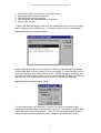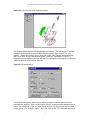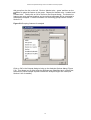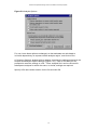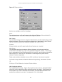
1
Scottish Natural Heritage Land Cover Change in Scotland The National Countryside Monitoring Scheme Visualisation and Analysis System User Guide National Countryside Monitoring Scheme Visualisation and Analysis System Use of this software is subject to a licence agreement. The full licence can be found in the file ncmslicence.pdf on the CD-ROM. In addition, a summary, highlighting the main terms of the licence, can be found in ncmsfaq.pdf. National Countryside Monitoring Scheme Visualisation and Analysis System Contents 1. INTRODUCTION......................................................................................................................... 1 2. THE NATIONAL COUNTRYSIDE MONITORING SCHEME ............................................. 2 3. ESTIMATING LAND COVER ................................................................................................... 3 4. GETTING STARTED................................................................................................................... 4 1.1 4.2 4.3 4.4 4.5 5. PRE-REQUISITES .......................................................................................................................... 4 INSTALLATION ............................................................................................................................. 4 NETWORK INSTALLATION ............................................................................................................ 4 UN-INSTALLING ........................................................................................................................... 4 STARTING THE APPLICATION........................................................................................................ 5 TUTORIAL ................................................................................................................................... 7 5.1 DISPLAYING LAND COVER IN A SAMPLE SQUARE .......................................................................... 7 5.2 ESTIMATING LAND COVER CHANGE.............................................................................................. 9 6. APPLICATION REFERENCE ................................................................................................. 17 6.1 VIEW SQUARE ............................................................................................................................ 17 6.2 DEFINE REGION ......................................................................................................................... 20 6.3 DEFINE FEATURE GROUPS ......................................................................................................... 22 6.4 NEW ANALYSIS.......................................................................................................................... 23 6.4.1 Specifying outputs ............................................................................................................ 23 6.4.2 Analysis options ............................................................................................................... 24 6.4.3 Running the analysis ........................................................................................................ 27 6.5 RETRIEVE ANALYSIS.................................................................................................................. 28 6.6 HELP .......................................................................................................................................... 28 7. RESULTS..................................................................................................................................... 29 7.1 DIAGNOSTIC REPORT ................................................................................................................. 29 7.2 ESTIMATE REPORTS ................................................................................................................... 30 REFERENCES..................................................................................................................................... 32 APPENDIX 1: THE NCMS LAND COVER FEATURES.............................................................. 33 APPENDIX 2: DATASET ANOMALIES ........................................................................................ 37 Changes to the classification ........................................................................................................ 37 Sampling issues ............................................................................................................................. 37 Gaps in the stratification............................................................................................................... 39 Coastline ....................................................................................................................................... 39 APPENDIX 3: ESTIMATION METHODS ..................................................................................... 40 APPENDIX 4: CALCULATION OF RESULTS .............................................................................. 42 Terminology .................................................................................................................................. 42 Estimates and standard errors ...................................................................................................... 42 Confidence intervals...................................................................................................................... 44 APPENDIX 5: SQUARE AND STRATA CODES............................................................................ 45 APPENDIX 6: FEATURE CODES .................................................................................................... 46 APPENDIX 7: METADATA .............................................................................................................. 47 i National Countryside Monitoring Scheme Visualisation and Analysis System 1. Introduction The National Countryside Monitoring Scheme (NCMS) is a major study of land cover change in Scotland. Using aerial photography, the study interpreted and mapped land cover for the late 1940s, the early 1970s and the late 1980s for 467 sample squares across Scotland. This enabled habitat change throughout Scotland to be quantified for the first time. The NCMS Visualisation and Analysis System is an advanced ArcView GIS application which allows full interactive access to the NCMS dataset. A flexible userinterface permits visualisation and quantification of land cover change within each of the sample squares. Land cover change within user-defined geographical regions can be estimated through an extrapolation process. The GIS tools are divided into two broad categories: • • Viewing tools Analysis tools Viewing tools enable maps of land cover to be displayed for NCMS sample squares. Key features include the following. • • • • • Selection of sample squares, from a map or a list; selection of the time period and features to be displayed; examination and quantification of land cover changes; a range of presentational layouts; and creation of standard ‘Views’ of selected squares, suitable for further analysis. Analysis tools enable the definition of geographical regions of interest for estimating land cover stock and change, extrapolated from sample data. Key features include the following. • • • • • Regions of interest can be selected from existing coverages or by delineating areas with the mouse; control over extrapolation methodology; habitat features can be grouped according to user interest; analysis reports can be saved for further analysis or presentation; and analysis settings can be saved for later re-use and adjustment. The system is straightforward to use. Nonetheless, a basic knowledge of ArcView would be helpful, and, to make best use of the analysis tools and results, an understanding of statistical sampling and estimation is recommended. 1 National Countryside Monitoring Scheme Visualisation and Analysis System 2. The National Countryside Monitoring Scheme Looking back over the latter-half of the twentieth century, considerable changes have become evident in Scotland’s urban and rural environments. Some changes, such as urban expansion and afforestation, have been striking. More subtle and cumulative changes, such as in the structure of farmland or the extent and condition of moorland, may be less obvious. Yet they are no less relevant to the visual appearance of the countryside, to its wildlife, and to opportunities afforded for outdoor recreation and enjoyment. Archive air photography has made it possible to look back over this period, to investigate and quantify change: its magnitude, rate and geographical variation. A land cover audit, known as the National Countryside Monitoring Scheme (NCMS), sampled photography from around 1947 (as the imperative for economic growth promoted the modernisation and expansion of farming and forestry) to around 1973 (when the UK joined the European Economic Communities) and then to 1988 (as environmental balance in rural policies was receiving greater recognition). It was impracticable to interpret photography for the whole of Scotland. Instead, a stratified random sample (representing 7.5% of Scotland’s land area) was developed to estimate the extent of land cover features and changes through time. Stratification was performed (on a regional basis) by the classification of Landsat multi-spectral scanner images. Each stratum was sampled to select photography for interpretation. The sample size was determined by a need to detect national changes of 10% or more in the major features, with 95% confidence. Land cover was classified in terms of 31 areal features, such as heather moorland, and five linear features, such as hedgerow (see Appendix 1). Each sample square (there were 467 in all, of 5km x 5km or 2.5km x 2.5km in size), was mapped at a scale of 1:10,000. The minimum mapping resolution was around 0.1ha for areal features and 30m for linear features. Land cover maps for each sample square were digitised for processing on a Geographical Information System (GIS). This enabled the land cover in each sample square to be calculated for each time period. Overlay analyses performed the computation of land cover change between time periods. Statistical software allowed GIS outputs to be combined with sampling information to estimate land cover at different geographical scales. Extent and change in extent can be estimated for each land cover type, as well as the amount of change between pairs of areal features, termed ‘interchange’. A summary of the NCMS, its method and main results, can be found in the folder called ncms summary on the CD. Double click on start.htm or open this file in your web browser to begin. 2 National Countryside Monitoring Scheme Visualisation and Analysis System 3. Estimating land cover An understanding of how land cover is estimated from the NCMS sample squares is important for interpreting results for a region of interest. Scotland was stratified through a classification of Landsat multi-spectral scanner images. To avoid difficulties of edge-matching, the strata were defined separately for each of the 12 former (pre-April 1996) Regional authorities, and, in some cases, for each District in a Region. From two to five strata were defined, roughly corresponding to lowland, upland, intermediate and urban areas (two upland strata were defined in Highland). This resulted in a total of 80 strata overall. Sample squares were initially 5km x 5km in size and a sample was selected randomly to cover 10% of each stratum. A statistical review was subsequently able to optimise this design. It resulted in the size of squares being reduced to 2.5km x 2.5km (a quarter of the original size) and a fixed sample size of five squares per stratum being selected. The intensity of sampling therefore varies between strata. Figure 3.1 NCMS sample square coverage Estimates for a geographical region are formed by calculating estimates for each stratum in the region and adding them together. Stratum estimates are formed by extrapolating the data from the squares in each stratum. Standard errors, and confidence intervals are calculated to provide measures of uncertainty due to sampling. In a study as complex as the NCMS there are inevitably sources of error, e.g. when interpreting features from aerial photography and when digitising boundaries. These errors are not thought to result in substantial bias in most cases (see the references for further information). User-defined regions of interest (termed ‘Analysis Regions’) are likely to cover several NCMS strata, either partially or completely. Some may be poorly represented by NCMS squares within the region, or, in extreme cases, contain no sample squares at all. In such cases it is necessary to include squares falling outside the Analysis Region when calculating estimates. Therefore, estimation relies upon an assumption that strata are sufficiently uniform for squares outwith the region to be representative of land cover within the region. In many cases this is likely to be valid as strata are generally small and reasonably homogeneous, or similar within themselves. The validity of this assumption can be evaluated from diagnostic information accompanying each analysis. For regions where this assumption proves questionable, the results of the analysis should be regarded as indicative only. 3 National Countryside Monitoring Scheme Visualisation and Analysis System 4. Getting Started 4.1 Pre-Requisites Software The NCMS application is an Extension for ArcView GIS 3.2 running within a Windows operating system. Crystal Reports (supplied with ArcView) must be installed. Hardware The application uses some very large datasets, requiring at least a Pentium 200 processor and 64mb of RAM. Speed can be greatly improved if the data are read from the hard drive of the PC rather than the CD-ROM. If the datasets are kept on the CD-ROM, about 3mb of disk space is required for installation. If the data are to be copied to the hard drive a total of about 650mb of disk space is required. 4.2 Installation Insert the CD and, if autorun is enabled, the installation program should start automatically. Otherwise, run the program X:\setup.exe, where 'X' is the drive letter of your CD-ROM drive, and follow the on-screen instructions. A number of folders will be created to hold the NCMS data, reports, analysis files, online help and temporary files. You will be given the option to install the datasets onto the PC’s hard drive. 4.3 Network Installation The installation program will attempt to copy the NCMS Extension to the default ArcView extensions folder. For some network installations this folder may be inaccessible. The setup program will warn you if it is unable to install the extension and you, or your network administrator, will have to manually copy the file ncms.avx to the correct folder. This file can be found in the folder called main on the CD. 4.4 Un-installing If you wish to keep any NCMS Analysis files that have been saved in the NCMS 'analysis' folder, first copy these to a safe location. Then delete the folder that the application was installed to (by default this will be C:\ncms). Finally, delete the NCMS extension ncms.avx from the ArcView extensions folder. 4 National Countryside Monitoring Scheme Visualisation and Analysis System 4.5 Starting the Application 1. Start ArcView in the normal way. 2. Select the Extensions option from the File menu. 3. From the list of extensions tick ‘NCMS’ and click OK. A splash screen will be displayed while the extension loads. A new View will be created called NCMS Main View (Figure 4.1). This will have three themes: • • • NCMS squares Coastline Stratification This View is a simplified version of the standard ArcView interface. The only addition is an NCMS menu. If any other window is activated, such as a normal View, ArcView will revert to its standard interface. Figure 4.1 The NCMS Main View New themes can be added to the NCMS Main View in the usual way. Standard ArcView resizing tools can be used to enlarge or zoom in on the View. If a project is saved with the NCMS application active, the NCMS extension will automatically be loaded when the project is next opened. 5 National Countryside Monitoring Scheme Visualisation and Analysis System To unload the application, uncheck the tick next to ‘NCMS v1.5’ in the list of extensions, and click OK. This will cause the NCMS Main View to disappear, so ensure that your project is saved first. Before using the application it is recommended that you choose the printer you intend to use by selecting ‘Print Setup…’ from the File menu. This will help ensure that margins are correctly set in ArcView layouts. For information on any remaining known issues with the software consult the ncmsissues.pdf file on the CD-ROM. 6 National Countryside Monitoring Scheme Visualisation and Analysis System 5. Tutorial This chapter introduces the main features of the application in the form of a step-bystep guide. A reference for each of the NCMS menu items can be found in Chapter 6. The NCMS application has two main functions: • to display and analyse NCMS land cover data for a selected NCMS sample square; and • to enable estimates of land cover and land cover change to be calculated for a user-defined geographical area (referred to as the ‘Analysis Region’). These functions are accessed though the NCMS menu and by interacting with the NCMS Main View. 5.1 Displaying land cover in a sample square To display land cover within an NCMS sample square, first select ‘View Square’ from the NCMS menu (if the NCMS menu is not visible, make sure the NCMS Main View window is active). You should see the dialog shown in Figure 5.1. Figure 5.1 The NCMS Square Viewer Dialog Each square has a unique code: a number followed by either two or three letters. The letters refer to the NCMS region or district containing the square. The square selected in Figure 5.1 is in Grampian. A list of the districts and their codes can be found in Appendix 5. 7 National Countryside Monitoring Scheme Visualisation and Analysis System You can select the square to be viewed in two ways. Either • click on the drop down box at the top of the dialog, next to ‘Selected NCMS Square’ and select a square from the list; or • click on a square in the NCMS Main View. If necessary, enlarge the View window, and zoom in on part of the map, to make it easier to select the square you want. Once selected, the square should be highlighted in the View. Only one square can be selected at a time. Leave the rest of the View Square dialog unchanged and click on OK. Once processing is complete, an ArcView layout and a report window should be displayed. The report window will be on top. These should be similar to those shown in Figure 5.2 and 5.3. Figure 5.2 The interchange report for the square selected in Figure 5.1 8 National Countryside Monitoring Scheme Visualisation and Analysis System Figure 5.3 The layout for the square selected in Figure 5.1 The report window shows the amount of change in the sample square from one feature to another, between the 1940s and 1980s. These changes are ordered by size; ‘no change’ indicates the area that was unchanged; and ‘outside cover’ includes areas within the sample square that were not interpreted (usually because they fell outside a regional boundary or because insufficient aerial photography was available). The report can be printed or saved for later use (see Section 6.1), but for now simply close or minimise the report window to reveal the layout. The layout shows the interpreted land cover for the sample square for c.1947 and c.1988 together with the areas that changed between these dates. The largest 25 interchanges are colour coded and displayed in the legend, ordered by size. Smaller interchanges are grouped into ‘other’ and areas that showed no change are left blank (Figure 5.3). The size and grid reference of the square are shown in the bottom right of the layout with a map showing its location. Other features of the View Square dialog enable you to • select which dates to display; • display areal and/or linear features; • create a standard View of the square to enable further analysis and combination with other datasets; • calculate the area of each feature; and • select the size of layout, for printing. See Section 6.1 for further details. 5.2 Estimating land cover change Estimation of land cover, land cover change and interchange for a geographical region involves the following steps: 9 National Countryside Monitoring Scheme Visualisation and Analysis System 1. 2. 3. 4. 5. Defining the region of interest (the Analysis Region) Specifying which results are required Defining feature groups (optional) Specifying how the results should be calculated Running the analysis To define the Analysis Region, make sure the NCMS Main View is active and select Define Region from the NCMS menu. The dialog shown in Figure 5.4 will appear. Figure 5.4 Defining an Analysis Region Regions can be defined from existing ArcView themes or by drawing the boundary on the NCMS Main View (see Section 6.2 for full details). For this exercise, click on ‘By drawing areas(s) with mouse’ and click OK. A dialog will appear prompting you to save the Analysis Region theme. Specify a file name and a location for the theme and click OK. The drawing tools shown in Figure 5.5 will then be displayed. Figure 5.5 Draw Analysis Region dialog Try using the polygon tool (selected in Figure 5.5) to draw an Analysis Region enclosing the Western Isles, as illustrated in Figure 5.6. Remember to double-click to define the last vertex of the polygon. Click on OK in the Draw Analysis Region dialog and the Analysis Region theme will be added to the NCMS Main View. 10 National Countryside Monitoring Scheme Visualisation and Analysis System Figure 5.6 The Western Isles Analysis Region The Outputs dialog will then be displayed automatically. This allows you to specify the dates and features for which estimates are required (see Section 6.4.1 for details). Check the tick box next to ‘40s-80s’ under ‘Net Change’ and ensure that both ‘Areal’ and ‘Linear’ are checked under ‘Features’, as shown in Figure 5.7. Estimates and confidence intervals will then be calculated comparing the 1940s and 1980s for both areal and linear features. Figure 5.7 Outputs dialog The Outputs dialog also allows you to define groups of features which are then combined for analysis. Click on the ‘Define Groups’ button and the dialog shown in Figure 5.8 will appear. Click on ‘New Group’ and you will be prompted for a name for the group. For example, type in ‘mire’ and click on OK. You can add features to 11 National Countryside Monitoring Scheme Visualisation and Analysis System this group from the list on the left. Click on ‘blanket mire – grass’ and then on the button to place the feature in the group. Repeat for ‘blanket mire – heather’ and ‘lowland mire’. Finally click on OK to return to the Outputs dialog. The three mire features are now grouped together and a combined estimated will be calculated in subsequent analyses. Further information on combining groups can be found in Section 6.3. Figure 5.8 Grouping features for analysis Click on OK in the Outputs dialog to bring up the Analysis Options dialog (Figure 5.9). This allows you to affect how the estimates are calculated and, in particular, the extent to which sample squares outwith the Analysis Region are used (see Section 6.4.2 for details). 12 National Countryside Monitoring Scheme Visualisation and Analysis System Figure 5.9 Analysis Options For now, leave these options unchanged, so that estimates are calculated to ‘minimise dependency on squares outwith analysis region’, and click on Run. A ‘Summary Options’ window will then appear, itemising the settings selected in the Outputs and Analysis Options dialogs (Figure 5.10). Click on OK and you will prompted to save the settings in a file. These ‘analysis files’ can be retrieved for subsequent analyses for which the same, or similar, settings are required. Specify a file name and a location for the file and click OK. 13 National Countryside Monitoring Scheme Visualisation and Analysis System Figure 5.10 Summary of selected options The system will then proceed with calculation of the estimates. This can take some moments, depending on the options chosen and the size of the Analysis Region. Once complete, several report windows will appear. On top will be the diagnostic report, which for the Western Isles Analysis Region should look like that in Figure 5.11. This report summarises the dependency of the results on squares outwith the Analysis Region (see Section 7.1 for a full description). In this example the Analysis Region contains only two NCMS sampling strata and all the sample squares in these strata fall within the Region. Thus there is no dependency on outside squares. This will rarely be the case and for most Analysis Regions some outside squares will have to be used. 14 National Countryside Monitoring Scheme Visualisation and Analysis System Figure 5.11 Diagnostic report for the Western Isles Close, or minimise this window to reveal the estimates for linear features (which should be similar to that shown in Figure 5.12). The estimated length of each linear feature is given for the 1940s and 1980s as well as changes between these dates. The ‘lower’ and ‘upper’ figures are the 95% confidence limits around each estimate. A guide to the interpretation of results can be found in Section 7.2. Figure 5.12 Linear feature estimates for the Western Isles Minimising or closing the linear estimates report will reveal a similar report containing estimates and confidence intervals for areal features. This table should contain estimates for ‘mire’, the feature group defined earlier. 15 National Countryside Monitoring Scheme Visualisation and Analysis System Finally you can save results in a variety of file formats for further analysis or presentation (see Section 6.1). 16 National Countryside Monitoring Scheme Visualisation and Analysis System 6. Application Reference The NCMS menu has the following options, which are described below. Menu option Description View Square Opens the ‘NCMS Square Viewer’ dialog, allowing squares to be selected and displayed. Define Region Allows the user to create an Analysis Region (the first step in the estimation process). Define Feature Groups Allows features to be combined into groups prior to analysis. New Analysis Allows the user to specify and perform an analysis (dialogs allow selection of desired results and estimation method). Retrieve Analysis Opens a previously saved set of analysis options and associated Analysis Region. Help Displays on-line help. 6.1 View square The NCMS Square Viewer dialog is shown in Figure 6.1. Select squares from the drop down list in the dialog or by clicking on the square in the NCMS Main View. In case of difficulty in selecting squares, ensure that the NCMS squares theme is active (slightly raised in the list of themes) and the ‘select feature’ tool is active (this is the default when this dialog is opened). 17 National Countryside Monitoring Scheme Visualisation and Analysis System Figure 6.1 The NCMS Square Viewer Dialog Display options for the selected square are grouped under a number of headings: Land Cover Select one, two or three dates of interest. Change Select one time period to show the major land cover changes between two dates. The land cover for these dates will also be selected automatically. To undo your selection, simply click on any of the checked boxes. Display Features Select whether to display areal and/or linear features. Format Data can be displayed in a standard ArcView View and/or a presentational Layout. Calculated Areas If this box is ticked then the map legends will show the extent of each feature in the square, for each date selected. Layout Template Select the required size of Layout for printing, using the drop-down list. Note that a distinction between ‘blanket mire - grass‘ and ‘blanket mire - heather’ was not made in Borders, Dumfries & Galloway, Grampian, Lothian, Orkney Islands or Shetland Islands for the 1940s and 1970s. Most of the blanket mire in these Regions will have been coded as ‘blanket mire - heather’ for these dates. Similarly, ‘built’ and ‘transport corridor’ were not identified separately in Grampian and Lothian 18 National Countryside Monitoring Scheme Visualisation and Analysis System for the 1940s and 1970s and transport corridor will have been coded as ‘built’ for these dates. Thus, an apparent sharp increase in the area of transport corridor between the 1940s and 1980s, say, is likely to be due to ‘built’ land being reclassified as ‘transport corridor’ for the 1980s maps. Interchanges between these features are also likely to be misleading. If a change map is selected a separate report window will appear displaying the full list of interchanges (for an example see Figure 5.2). To switch between pages use . the arrow keys, To print a table click on the print button, above the report. . To save the table in a spreadsheet, or other format, click on the export button This brings up the dialog shown in Figure 6.2. Select a Format to save the report in and a Destination (usually ‘Disk file’). Click OK and you will be prompted for the name and location of the file to be saved. Figure 6.2 Exporting reports This report is overwritten each time a new square is viewed. If a View of the selected square has been requested, each date and interchange will be displayed as separate theme (Figure 6.3). An example of a layout is shown in Figure 5.3. Finally, if you wish to highlight particular features or groups of features in a square by selecting them, you will need to construct a query by selecting the theme you wish to query in the square's View and then selecting 'Query…' from the Themes menu. The underlying NCMS dataset uses short letter codes to identify land cover features and these have to be used in queries instead of the feature names. The table in Appendix 6 shows the code used for each feature. 19 National Countryside Monitoring Scheme Visualisation and Analysis System Figure 6.3 The View of the square selected in Figure 6.1 6.2 Define Region An Analysis Region can be defined by selecting or drawing a boundary in the NCMS Main View. This Region can be represented by a single contiguous area or a series of geographically separate areas. Although estimates will be calculated for almost any Analysis Region, they will not be meaningful if the region is either very small or consists of NCMS strata whose sample squares lie mainly outside the Region. 2 As a rule of thumb, Regions smaller than the area of Fife (about 1,500 km ) are likely to give estimates with wide confidence intervals or will contain too few sample squares to enable reliable estimation. The exception to this rule is that if the Analysis Region corresponds with a former local authority District, it will usually contain sufficient squares. Large regions may nevertheless present problems if results are heavily dependent on outside squares. An examination of the diagnostic information should make it clear if there are any sizeable strata for which most of the sample squares used lie outside the Region. This can be checked visually by examining the Analysis Region together with the stratification and sample squares in the NCMS Main View. Selecting ‘Define Region’ from the NCMS menu provides three methods for defining an Analysis Region: • ‘From an existing theme’ selects an area, or areas, from an existing coverage. • ‘By drawing area(s) with mouse’ allows you to define your area of interest using ArcView’s drawing tools. • ‘From current selection of active theme’ uses the currently selected area in the NCMS Main View. 20 National Countryside Monitoring Scheme Visualisation and Analysis System a) From an existing theme Selecting this option will display the dialog shown in Figure 6.4. Figure 6.4 ‘From an existing theme’ dialog If you have already added an ArcView theme, from which the Analysis Region is to be defined to the NCMS Main View, you can select it from the drop-down list. Otherwise, click on the ‘New’ button and select the file containing this theme from the ‘Add theme’ dialog that appears. Next, use the selection tools to select the polygons in this theme that define the Analysis Region. You may include several polygons either by clicking in each polygon while holding down the ‘shift’ key, or by drawing a boundary around the polygons to be included. Once the required selection(s) have been made, click on the ‘OK’ button. A dialog will appear prompting you to save the Analysis Region theme. Specify a file name and a location for the theme which will then be added to the NCMS Main View. b) By drawing area(s) with mouse Selecting this option will display a dialog asking where the new Analysis Region theme should be saved. Specify a file name and a location for the theme. The drawing tools provided can be used to draw the boundaries of the new Analysis Region (Figure 6.5). Once the required area, or areas, have been drawn, click the OK button to save the Analysis Region. 21 National Countryside Monitoring Scheme Visualisation and Analysis System Figure 6.5 Draw Analysis Region dialog c) From current selection of active theme Choose ‘From current selection of active theme’ if you have already selected the required region in the NCMS Main View. You will be prompted for a file name and location to save the Analysis Region theme. 6.3 Define Feature Groups Related land cover features, such as the various types of woodland, can be grouped together for analysis. Although estimates for a group of features can be calculated by summing the separate estimates, standard errors and confidence intervals can only be found by analysing the group as a whole. The dialog for creating groups (Figure 6.6) can either be accessed from the ‘Define Feature Groups’ option on the NCMS menu or from the Outputs dialog (see Section 6.4.1). Figure 6.6 Grouping features for analysis 22 National Countryside Monitoring Scheme Visualisation and Analysis System Grouping features together involves creating a group, such as ‘woodland’, and then allocating features to that group. 1. To create a new group, click on the ‘New Group’ button and enter a name for the group. button to add it to the group. Repeat until all the 2. Select a feature and use the button to remove required features are in the group. You can use the features. 3. The ‘Groups:’ drop-down list can be used to move between different groups. 4. Click on the ‘Delete Group’ button to completely remove a group (all features in that group will be returned to the main list). 5. The ‘Change to linear / areal groups’ button is used to switch between the two structural types. Groups cannot contain both areal and linear features. 6. Click OK when finished. Two special cases: 1. A distinction between ‘blanket mire - grass‘ and ‘blanket mire - heather’ was not made in the strata in Borders, Dumfries & Galloway, Grampian, Lothian, Orkney Islands or Shetland Islands for the 1940s and 1970s. By default, these features will be grouped together as ‘blanket mire’ if the Analysis Region includes any such strata. If they have been placed in separate groups, they will be removed automatically from those groups and grouped as ‘blanket mire’ for analysis. 2. Similarly, ‘built’ and ‘transport corridor’ were not identified separately in the Grampian and Lothian strata for the 1940s and 1970s. They are therefore treated in a similar way to blanket mire. 6.4 New Analysis 6.4.1 Specifying outputs The Outputs dialog is used to specify the dates and features for which estimates are required. This dialog appears once a new Analysis Region is defined or it can be accessed by selecting ‘New Analysis’ from the NCMS menu (Figure 6.7). 23 National Countryside Monitoring Scheme Visualisation and Analysis System Figure 6.7 Outputs dialog Options are available under four headings: Stock The estimated amount of each feature in the Analysis Region will be calculated for each date selected. One, two or three dates may be selected. Net Change The estimated change in area or length of each feature over the selected time period will be calculated. Only one period can be selected, so if estimates for 40s-70s and 70s-80s, say, are required, two separate analyses will have to be run. Features Selects whether results for areal and/or linear features are required. Interchange The estimated interchange between different features during the selected time period will be calculated (e.g. how much grassland changed to arable). Interchange can be estimated only for areal features and only one time period can be selected for each analysis run. Note that the calculation of interchanges may take several minutes on slower computers. Finally, select whether standard errors or 95% confidence intervals are required. The Define Groups button activates the Define Groups dialog, described in Section 6.3. Clicking on OK will display the Analysis Options dialog. 6.4.2 Analysis options The Analysis Options dialog (Figure 6.8) is split into two sections. ‘Analysis Method’ offers four choices determining how results should be calculated. These determine which squares are used to calculate the estimates and associated standard errors (and hence confidence intervals). See Appendix 3 for further detail. 24 National Countryside Monitoring Scheme Visualisation and Analysis System ‘Special Cases’ permits the automatic grouping of certain features to be overridden (see Section 6.3). This will only be required in exceptional circumstances. Figure 6.8 Analysis Options Analysis Method The more sample squares that are used in an analysis, the more precise will be the resulting estimates. Hence, confidence intervals will be narrower. Maximising the sample size usually means making use of data from squares outwith the region. This may reduce the accuracy of the results if the outside squares are not representative of land cover within the region. The Analysis Options dialog permits selection of the extent to which outside squares are used. The options are as follows: Minimise dependency on sample squares outwith analysis region Outside squares are used only when unavoidable. As the safest option, this will give relatively low precision and the standard errors may be poorly defined, but minimises loss of accuracy. Minimise dependency on sample squares outwith the analysis region for estimates only Estimates are calculated using only inside squares where possible. Standard errors are calculated using all squares in each stratum, whether or not they fall within the defined region. This means that relatively accurate estimates can be calculated with reduced standard errors. This relies on the assumption that variability between squares is similar within and outwith the region. Use all sample squares in strata Use this method to maximise precision. This will be fairly safe if most squares are inside the region or if the strata that make up the bulk of the region are mostly contained within the region. The greatest benefit is achieved when there are many outside squares that would otherwise be excluded from the analysis. The diagnostic information should be used to assess the extent of dependency on outside squares. A safer method should be used if there is a strong possibility of bias. 25 National Countryside Monitoring Scheme Visualisation and Analysis System Define analysis options for each stratum individually This option displays the Advanced Analysis Options dialog (Figure 6.9) and allows the analysis method to be varied between strata. Figure 6.9 Advanced Analysis Options To change the squares that are used for each stratum, click on the stratum and tick the Estimate box to use all squares for the estimate (which will then register ‘true’). Tick the Standard Error box to use all squares for standard errors (and hence confidence intervals). If these boxes are not ticked, only squares inside the Analysis Region will be used. Only valid methods can be specified (for example, it is not possible to calculate estimates for a stratum using only inside squares if there are no inside squares). This option is used to ‘fine tune’ an analysis by increasing the number of squares used for a stratum that may otherwise produce unreliable estimates. For most strata the number of inside squares may be adequate but for a few it may be desirable to use outside squares either to improve precision or to improve the validity of the estimate. For example, a stratum may have only one square in the Region and four outside. An estimate based on the one square may not be representative of the land cover for that stratum, whereas the five squares combined will be more so. Similarly, two squares are enough to calculate a standard error but one calculated from five squares is likely to have greater validity and give a more precise estimate. Special Cases As discussed in Section 6.3, ‘blanket mire - grass‘ and ‘blanket mire - heather’ were not differentiated in all strata for the 1940s and 1970s. Similarly for ‘built’ and ‘transport corridor’ (see Appendix 2 for details). Thus, if the Analysis Region includes any such strata, these features will be automatically combined. However it may be evident from the diagnostic report that such strata only account for a small proportion of the Region. In such cases you can tick either, or both, of the check 26 National Countryside Monitoring Scheme Visualisation and Analysis System boxes to force these features to be kept separate (see Appendix 5 for a list strata codes). Use these options with caution. If the strata for which the features were not differentiated occupy a substantial proportion of the Region, misleading results may be given. For example, all built and transport corridor was coded as ‘built’ in Grampian and Lothian in the 1940s and 1970s. In this case, results comparing the 1940s and 1980s may suggest an apparent sharp increase in the amount of transport corridor if the features are kept separate. Finally, the Analysis Options dialog can be used to select whether or not feature groups (see 6.3) are to be used in the analysis. Accordingly, the analysis can be based on all individual features or on any groupings that have been defined. 6.4.3 Running the analysis Clicking the ‘Run’ button on the analysis options dialog presents a summary of the selected output and analysis options (Figure 6.10). Figure 6.10 Summary of analysis options Check the settings are as required and click OK to continue with the analysis or Cancel to return to the Analysis Options dialog. If you continue you will be prompted to save these settings in an analysis file. The analysis file can be opened at a later date to repeat a particular analysis (see Section 6.5). Specify a file name and a location for the file and click OK. 27 National Countryside Monitoring Scheme Visualisation and Analysis System The system will then proceed with calculation of the estimates. This can take some moments, depending on the options chosen and the size of the Analysis Region. 6.5 Retrieve Analysis Key settings used in the analysis are saved in an analysis file (see 6.4.3). These can be retrieved to repeat or modify an analysis (i.e. without having to define the analysis again from scratch). It can also be used to perform the same analysis on a new Analysis Region (i.e. using a pre-defined set of options). The analysis file contains • the name and location of the Analysis Region shapefile; • the definition of any areal and linear feature groups, if relevant; • output options; and • specific strata settings if these were defined in ‘Advanced Analysis Options’. ‘Retrieve Analysis’ on the NCMS menu is used to load an existing analysis file. You will be prompted for the location of the file. If the Analysis Region shapefile, specified in the analysis file, no longer exists a message will appear to that effect. The definitions of feature groups and output options will still be loaded. Thus pre-defined feature groups need not be re-defined for each new Analysis Region. 6.6 Help Selecting ‘Help’ from the NCMS menu provides access to summary information on the application and its features. The topics available are shown in Figure 6.11. Figure 6.11 Help topics 28 National Countryside Monitoring Scheme Visualisation and Analysis System 7. Results The results of each analysis are displayed as reports, with each report in a separate window. A table may occupy several pages within a report. 7.1 Diagnostic Report For each analysis, a diagnostic report summarises the utilisation of squares for the analysis and, in particular, the dependency on squares outside the Analysis Region. The table shows the number of sample squares used to calculate estimates and standard errors and the area of each stratum in the Region (Figure 7.1). Figure 7.1 Diagnostic report Estimates are calculated for each stratum and then summed to generate Region estimates. Region estimates will be more dependent on squares outside the Region if estimates for the biggest strata in the Region are heavily dependent on outside squares. This will be the case if a sizeable proportion of the squares used for these strata are outside the Region. Strata that have a small proportion of their area in the Region are more likely to have required the use of outside squares, but they will tend to contribute less to the overall estimate. The map shows the Analysis Region together with the squares and strata used in the analysis. The full extent of each stratum, and its squares, will be shown if outside 29 National Countryside Monitoring Scheme Visualisation and Analysis System squares were used to calculate either the estimates or standard errors for that stratum. In this way, the geographical extent of the squares that are used can be visualised. Heavy dependency on outside squares does not necessarily invalidate an analysis, but results should be viewed with caution. It is more satisfactory if squares inside the Region make the greatest contribution to the estimates, but balanced against this is the benefit of improved precision if more squares are utilised. The NCMS sampling design resulted in a number of small strata being undersampled (see Appendix 2). 7.2 Estimate reports Report tables provide estimates of stock, net change or interchange between land cover features. Separate report windows show estimates for areal and linear features, and for interchanges. Each estimate will have an associated 95% confidence interval or standard error, depending on which was requested in the Output Options dialog. As estimates are based on a sample there is uncertainty as to the true extent of each feature in the Analysis Region. For change estimates there is uncertainty as to whether an estimated change represents a real change in the Region (the change in the sample might not be reflected across the whole Region). Confidence intervals define a range within which the true value lies with the specified level of confidence. • • For estimates of extent or interchange confidence intervals define a range for the true extent or interchange in the Analysis Region. For estimates of change, if the range of the confidence interval is all positive or all negative then it is likely that the change is real (i.e. if there had been no change in the Region, there is less than a 5% chance of the estimated change being as large). The use of 95% (rather than, say, 90%) confidence intervals is to some extent arbitrary, but it ensures that not many changes are interpreted as being real when in fact no change took place. Standard errors provide an alternative measure of uncertainty, or precision, in a feature’s extent or change. As standard errors will be larger for larger features, one way of comparing the precision between features is to calculate the coefficient of variation, which is simply the standard error divided by the estimate. Standard errors can also be used to calculate confidence intervals using the formulae presented in Appendix 4. Other sources of error are inevitable in a study as complex as the NCMS. These are more difficult to quantify than those due to sampling, but are worth bearing in mind. Errors can occur when interpreting features from aerial photography and when digitising boundaries. These errors are not thought to result in substantial bias in the majority of cases (further information can be found in the references provided). Figure 7.2 shows a report of area estimates for the 1940s and 1980s and net change between the1940s and 1980s, with 95% confidence levels. 30 National Countryside Monitoring Scheme Visualisation and Analysis System Figure 7.2 Example of an estimates report In this example the confidence interval for the change in rough grassland is all negative and so we can be reasonably confident that the change is real. The same cannot be said for smooth grassland, as its confidence interval ranges from –121 to 246. If insufficient data are available to calculate a confidence interval or standard error for an estimate, these values are left blank. 31 National Countryside Monitoring Scheme Visualisation and Analysis System References Mackey, E.C., Shewry, M.C. & Tudor, G.J. (1998). Land Cover Change: Scotland from the 1940s to the 1980s. The Stationery Office, Edinburgh. Tudor G.J., Shewry M.C., Mackey E.C., Elston D.A. & Underwood F.M. (1999). Land Cover Change in Scotland: The Methodology of the National Countryside Monitoring Scheme. Scottish Natural Heritage Research, Survey and Monitoring Report No. 127. Scottish Natural Heritage, Perth. Elston, D.A., Gauld, J.H., Miller, J.A., Shewry, M.C. & Underwood, F.M. (1999). The National Countryside Monitoring Scheme Accuracy Assessment. Scottish Natural Heritage Research, Survey & Monitoring Report No. 133. Scottish Natural Heritage, Perth. 32 National Countryside Monitoring Scheme Visualisation and Analysis System Appendix 1: The NCMS Land Cover Features The following descriptions provide a guide to how NCMS features were interpreted from aerial photographs. Grassland rough grassland Rank or tussocky grassland which may appear to have been drained, grazed, mown or treated with farm manure but not so improved by fertiliser or herbicides as to have altered the sward composition greatly. Associated with unenclosed upland sites, lowland sites with poor access or wet areas, and may include roadside verges. intermediate grassland Not decisively rough or smooth, the sward composition of intermediate grassland may appear to have been modified to a greater degree (than rough grassland) by land management practices such as the application of fertiliser or herbicide, heavy grazing pressure, or land drainage. smooth grassland Heavily modified by the application of fertilisers and/or herbicides, and may have been re-seeded (note that temporary grassland ley within an arable rotation was classed as ‘arable’, distinguished from smooth grassland by contextual detail. Mire blanket mire- heather Landscape form and vegetation cover, together with surface morphology, were used to infer the sub-surface presence of wet acidic peat under heather. If drained, heather-dominated mire was classified as heather moorland. When stripped of its surface vegetation it was classified as bare ground (or quarry where there was clear evidence of peat extraction). blanket mire-grass Landscape form and vegetation cover, together with surface morphology, to infer the sub-surface presence of wet acidic peat under rough grass. lowland mire Generally related to dome formations of raised bog, but includes unwooded fens. Heather Moorland Dwarf shrubs or regenerating burnt patches exceed 50% of the ground cover. 33 National Countryside Monitoring Scheme Visualisation and Analysis System Arable Without differentiating between crops, the classification includes arable crops, rotational grassland ley and horticulture. Woodland broadleaved woodland Broadleaved crowns account for more than 50% of the area and coniferous cover is less than 25%. Tree height is taller than 5 metres. mixed woodland Trees greater than 5 metres tall, natural or planted in appearance, and composed of more than 25% broadleaved and more than 25% coniferous tree cover. broadleaved plantation Even-aged stands of more than 50% broadleaved trees, normally not native to the site and dominated by one species. parkland May be a coniferous or broadleaved grouping of at least 10 trees providing 10 to 50% cover. coniferous woodland Irregular tree cover in excess of 50% and less than 25% broadleaved cover. young plantation Regularly planted coniferous (or broadleaved, but negligible in extent) trees of up to 3m in height. coniferous plantation Regularly planted conifers exceeding 50% of trees present with broadleaved cover less than 25%. felled woodland Areas in which at least 50% of woodland had been recently felled. Fresh Water lochs Irregular shaped expanse of water without evidence of impounding. reservoirs Expanse of water with evidence of impounding. rivers Flowing water of greater than 10m in width, without evidence of canalisation. streams Flowing water of less than 10m in width, without evidence of canalisation. 34 National Countryside Monitoring Scheme Visualisation and Analysis System canals Water course, greater than 10m width, which has been artificially confined to flow in a certain direction. ditches Water course, less than 10m width, which has been artificially confined to flow in a certain direction. marginal inundation Included swamp or fen margins typical of an open water transition, the banks of ponds and ditches subject to periodic inundation, and the draw-down zones of reservoirs. wet ground Small areas of wet land, such as wet areas in a pasture field or flushes in upland areas, often denoted by the presence of the rush Juncus, without evidence of peat formation. Built and Bare Ground built land Urban areas, including buildings, roads, gardens, parks and golf courses within the urban boundary, and buildings outside urban areas. recreation Land in the countryside, normally adjacent to urban areas, which was in formal recreation use. Includes sports fields, playing fields, golf courses, camping and caravan sites, ski runs and racing circuits. transport corridor Railways and surfaced roads greater than 3 metres in width which occurred outside built-up areas (greater than one building deep on either side of the road), including overbridges, carriageways, hard shoulders and other unvegetated roadway features. tracks Non-transient routeways of up to 3 metres width showing signs of use by wheeled vehicles. quarry Hard rock excavations, sand and gravel pits, open-cast mines and unvegetated spoil heaps. rock Associated mostly with the uplands and includes unquarried inland cliff, unvegetated rock, scree and limestone pavement. Due to the perspective of the photography, steeply inclined or vertical cliff face, such as coastal cliff, are not represented. bare ground Land not covered by vegetation which does not fall into any other category. It represents a transition phase and includes erosional features such as exposed gravel or soil in upland areas, but not temporarily bare arable. 35 National Countryside Monitoring Scheme Visualisation and Analysis System Bracken and Scrub bracken At least 50% bracken cover. low scrub Trees or shrubs which are less than 3m in height, with a range of canopy sizes and heights. tall scrub Dense canopy of trees or shrubs of 3m to 5m in height. Hedgerows and Trees hedgerow Shrubs and trees less than four metres in height and five metres in width, classified as continuous if gaps are less than 10 metres wide. treeline Often encountered along field margins, a minimum of 3 trees of greater than 4 metres in height and less than 2 canopy widths apart. 36 National Countryside Monitoring Scheme Visualisation and Analysis System Appendix 2: Dataset anomalies For certain areas of Scotland anomalies in the way sample squares were selected, or in the way the classification was applied, may affect the interpretation of results. In the vast majority of cases these will not be important, but the description below should enable an assessment of their likely effect on particular analyses. Changes to the classification As the NCMS study progressed it became apparent that changes to the feature classification were required to enable study of particular issues. Two features were sub-divided after the 1940s and 1970s interpretation had been completed in some regions: • No distinction was made between ‘built’ and ‘transport corridor’ in Grampian and Lothian Regions for the 1940s and 1970s interpretation. The distinction was made elsewhere, and in all Regions in the 1980s interpretation. For simplicity, these features have therefore been combined whenever the Analysis Region contains Lothian or Grampian strata. A warning to this effect will appear before the analysis is performed. • No distinction was made between ‘heather- dominated’ and ‘grass-dominated’ blanket mire in Borders, Dumfries & Galloway, Grampian, Lothian, Orkney Islands or Shetland Islands for the 1940s and 1970s interpretation. Again, for simplicity, these features have been combined whenever the Analysis Region contains a stratum from these regions. Sampling issues strata with only one sample square At the outset of the study a 10% sample was selected within each stratum. In two small strata this resulted in only one sample square being selected. This is insufficient to enable estimation of the standard error for these strata. In the analysis these standard errors have been set to zero which results in the overall standard error for any Analysis Region containing these strata being underestimated. In addition, confidence intervals will be slightly too narrow. Estimates for such Regions will still be unbiased and standard errors will only be substantially affected if these strata comprise a substantial part of the Region. This can be assessed using the diagnostic information provided with each analysis. If this is the case, keep in mind that the true confidence interval is wider than that shown. The extent of these strata and their characteristics are summarised below. 37 National Countryside Monitoring Scheme Visualisation and Analysis System Extent of strata with only one sample square Characteristics of strata with one sample square Strata NCMS district Type 2 Total area (km ) ork2 Orkney Moorland 147 cas3 Caithness and Sutherland Mixed, but heather dominated 77 Note that two other strata also have only one sample square, cst1 and tpk4, but in these cases the sample square comprises the full extent of the stratum. strata with no sample squares In addition, a number of small strata in North Argyll and the Strathclyde Islands were not sampled. The location of these and their characteristics are shown below. As estimates cannot be calculated for these strata, the total area for which results are presented will be slightly less than that of the whole Analysis Region. These strata are unlikely to comprise a substantial part of many Analysis Regions but the diagnostic information provided with each analysis will show how extensive the strata are in the Region. Extent of strata with no sample squares 38 National Countryside Monitoring Scheme Visualisation and Analysis System Characteristics of strata with no sample squares 2 Strata NCMS district Type Total area (km ) sis1 Strathclyde Islands Agricultural 84 sis2 Strathclyde Islands Moorland 126 sna1 North Argyll Agricultural 46 sna4 North Argyll Urban 6 Gaps in the stratification Certain small islands, such as Rum, were never included in the NCMS stratification and therefore not sampled. These areas are white on the stratification coverage. Whenever an Analysis Region includes such islands the results will be calculated for the ‘stratified’ part of the Region. Coastline The coastline presented in the NCMS Main View is relatively crude having been derived from the original NCMS stratification rather than from an Ordnance Survey dataset. Slight discrepancies with other coastline datasets should not be significant for most purposes. 39 National Countryside Monitoring Scheme Visualisation and Analysis System Appendix 3: Estimation methods Three methods are provided for calculating estimates and standard errors for each stratum in a region of interest. The method of choice will depend on whether maximising sample size, and hence precision, is more important than minimising the dependency on squares outside the region. Method A: Minimise dependency on sample squares outwith the region (possible if the stratum has two of more sample squares in the region) Estimates and standard errors for the stratum are calculated only from sample squares that fall within the region. Method B: Minimise dependency on sample squares outwith the analysis region for estimates only (possible if the stratum has one or more sample squares in the region) Estimates are based only on sample squares that fall within the region, but standard errors use all the sample squares in the stratum. This increases the reliability of standard errors by increasing the sample size for their calculation, but assumes that the variability between squares is similar within and outwith the region. Method C: Use all squares in the stratum (can always be used) Estimates and standard errors are based on all squares in the stratum regardless of whether they are inside the region. This increases the precision of the estimates by maximising the sample size available for estimation but makes the strongest assumptions. Not only is the assumption for Method B required, but also that the land cover in the strata is sufficiently homogeneous that squares outside the Region can be considered representative of land cover inside the Region. The validity of these assumptions is difficult to assess but diagnostic information (provided with the results of each analysis) can help to assess the extent of the dependency of the analysis on outside squares and whether caution is needed in interpreting the results. The figure below summarises the situations when each of the three methods is possible. However, these are minimum requirements and fairly imprecise results may be obtained if the number of sample squares used is small. 40 National Countryside Monitoring Scheme Visualisation and Analysis System Possible methods of analysis For stratum 1: Stratum Method A, B or C possible 3 1 Sample square Estimates and standard errors can be calculated from squares falling entirely within the region 2 Analysis Region of interest Method B or C possible, but not Method A 3 1 Unable to estimate the standard error for stratum 1 from the single square falling within the region 2 Only Method C possible 3 1 2 41 Unable to estimate the land cover or standard error for stratum 1 without using squares outwith the region National Countryside Monitoring Scheme Visualisation and Analysis System Appendix 4: Calculation of results Terminology Term Explanation Sj the j NCMS stratum Ij the intersection between the region of interest and the j stratum Aj the area of Ij ajk the total interpreted area in the kth sample square in Ij Yj the total area or length of the feature within Ij yjk the interpreted area or length of the feature in the kth sample square in Ij nj the number of sample squares Suffix Explanation j NCMS strata, j = 1...s k sample square, k = 1...nj th th The intersections, Ij, between regions and strata are illustrated, by example, below. strata S1 S2 S3 S4 Region A Intersection Area (Aj) I1 100 I2 50 I3 0 I4 0 Region B Intersection Area (Aj) I1 0 I2 200 I3 0 I4 150 In this example strata S1 and S2 overlap with region A, whilst S2 and S4 overlap with region B. Estimates and standard errors Suppose we are interested in a measurement, such as heather moorland area, for a user-defined region. The observed areas of heather moorland within the sample squares are yjk. The method to be adopted is to form estimates for the region by summing estimates for the strata represented in the region. The squares to be used for forming the estimate will either be those within Ij, the intersection of the region with strata Sj, or all squares within Sj. The number of squares used is nj . 42 National Countryside Monitoring Scheme Visualisation and Analysis System An estimate, Yˆj , of the total area or length for each non-empty Ij is required. An intuitive approach is to use the ratio estimator nj ∑y Y∃j = k =1 nj ∑a k =1 jk Aj jk The total area or length for the region can then be estimated by s Yˆ = ∑ Yˆ j j=1 with corresponding variance s n A ( 1- a / A) var(Yˆ ) = ∑ j ( jn -1)a 2j 2 j j =1 j nj ∑ (y jk - Rˆ j a jk )2 k =1 where nj ∑y Rˆ j = ∑a nj jk k =1 nj , a j = ∑ a jk k =1 jk k =1 and A = Aj if only squares in Ij are used, or the area of the stratum, if all squares in Sj are used Note that the land cover estimate for stratum j could be calculated using only squares in Ij and the variance calculated using all squares. Thus each strata can be treated differently and the calculation of variances treated differently to the calculation of the estimates themselves. Note that the estimate can only be calculated using just the squares in Ij if there is at least one sample square in Ij . Similarly the variance can only be calculated in this way if there are at least two squares in Ij . Estimates for land cover change are calculated in exactly the same way, substituting the interpreted change in the feature, within square k, for yjk . Similarly estimates of interchange between two features are calculated by substituting the interpreted interchange between the features within, square k, for yjk . To calculate the standard error of the estimate, simply take the square root of the variance. 43 National Countryside Monitoring Scheme Visualisation and Analysis System Confidence intervals 95% confidence limits for estimates or land cover stock or interchange are calculated assuming a log-normal distribution: lower limit = Yˆ K ˆ K upper limit = Y* where ∃] K = exp [1.96 * var( loge Y) and var(Yˆ) var( loge Yˆ) ≈ loge [1 + ] 2 Yˆ This gives asymmetric confidence intervals, with the lower limit closer to the estimate than the upper limit. The upper and lower 95% confidence limits for estimates of net change are calculated assuming a normal distribution: Yˆ + 1.96 * var(Yˆ) 44 National Countryside Monitoring Scheme Visualisation and Analysis System Appendix 5: Square and strata codes Each NCMS sample square has a unique code: a number followed by either two or three letters. The letters refer to the NCMS district and/or region containing the square. These are identified in the following table. In most cases the same codes are used in the NCMS stratification. The exception is Dumfries & Galloway (dag) where the stratification does not distinguish between districts. NCMS Region NCMS District Code bor Borders Central Clackmanan & Falkirk Stirling ccf cst Dumfries & Galloway Annandale & Eskdale Nithsdale Stewartry Wigtown dga dgn dgs dgw Fife fif Grampian gra Highland Badenoch and Strathspey Caithness and Sutherland Inverness and Nairn Lochaber Ross and Cromarty Skye and Lochalsh hbs cas hin hlo hrc hsl * Lothian lot Orkney ork Shetland she Strathclyde Ayrshire and Arran Clyde Valley Mid-Strathclyde North Argyll South Argyll Strathclyde Islands saa scv sms sna ssa sis Tayside Angus and Dundee Perth and Kinross tad tpk ws Western Isles * one square in Edinburgh is labelled ‘led’ 45 National Countryside Monitoring Scheme Visualisation and Analysis System Appendix 6: Feature codes The underlying NCMS dataset uses short letter codes to identify land cover features, rather than the feature names themselves. In normal usage these codes will remain hidden, but if, for example, you wish to construct a query to select particular features in a square, you will have to use feature codes. The table below shows the code used for each feature. Feature name Feature code Areal arable bare ground blanket mire - grass blanket mire - heather bracken broadleaved plantation broadleaved woodland built canals coniferous plantation coniferous woodland felled woodland heather moorland intermediate grassland lochs low scrub lowland mire marginal inundation mixed woodland parkland quarry recreation reservoirs rivers rock rough grassland smooth grassland tall scrub transport corridor wet ground young plantation A BG BMG * BM BR BP BW * B C CP CW FW HM IG L LS LM MI MW P Q R RE RI RK RG SG TS TC WG YP Feature name Feature code Linear ditches hedgerows lines of trees streams tracks DITCH HEDGE TREE STR TRACK outside cover OC * As detailed in Appendix 2, built and transport corridor, and heather-dominated and grassdominated blanket mire, were not distinguished in certain Regions in the 1940s and 1970s interpretation. In these cases the code 'B' was used for both built and transport corridor and 'BM' was used for both heather-dominated and grass-dominated blanket mire. 46 National Countryside Monitoring Scheme Visualisation and Analysis System Appendix 7: Metadata Title National Countryside Monitoring Scheme Alternative Title NCMS Originator Scottish Natural Heritage Abstract Study of land cover change in Scotland between c.1947, c.1973 and c.1988. Aerial photography was interpreted for a stratified a random sample of 5km by 5km squares (later 2.5km by 2.5km) and digitised and processed on a GIS. Statistical software allowed sample square data to be extrapolated to provide estimates of extent, change and interchange for a geographical region of interest. Land cover was interpreted in terms of 31 areal land cover features and five linear features. For each of the 467 sample squares, the interpreted features were mapped at a scale of 1:10,000 using a minimum mapping resolution of around 0.1 hectares for areal features and 30 metres for linear features. Access Constraints See licence agreement Data capture period c.1947, c.1973, c.1988 Frequency of update No update planned; conditional on comprehensive air-photo coverage Keywords land cover change Geographical Extent Scotland System of Spatial Referencing by Co-ordinates British National Grid Contact title of supplier NCMS support Postal address of supplier Scottish Natural Heritage 2 Anderson Place Edinburgh EH6 5NP Email address [email protected] 47