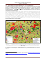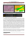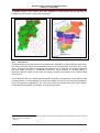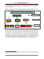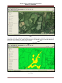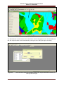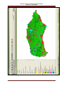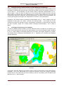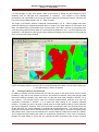
1
SUSSEX HISTORIC
LANDSCAPE
CHARACTERISATION
VOLUME I – USER GUIDE
Sussex Historic Landscape Characterisation
Volume I – User Guide
HISTORIC LANDSCAPE
CHARACTERISATION
West Sussex County Council
East Sussex County Council
Brighton & Hove Unitary Authority
English Heritage
AUGUST 2010
by
Dr Nicola R. Bannister AIFA
Landscape History & Conservation
-i-
Sussex Historic Landscape Characterisation
Volume I – User Guide
CONTACTS
East Sussex County Council - Historic Environment Record
Archaeology Section
Environmental Advice Team
Transport & Environment
East Sussex County Council
County Hall
St Annes Crescent
Lewes
BN7 1UE
TEL: 01273 481608
West Sussex County Council – Historic Environment Record
Archaeology Section
Planning Services
The Grange
Tower Street
Chichester
PO19 1RH
TEL: 01243 642105
English Heritage - Characterisation Team
Head of Team – Graham Fairclough
I Waterhouse Square
138-142 Holborn,
London
EC1N 2ST
TEL: 020 7973 3000
Front Cover: The ‘lost’ medieval deer park at Lurgashall, Chichester, West Sussex as seen on the OS
historic maps and as characterised in the HLC.
The Ordnance Survey map data included within this report is provided by West Sussex County Council under licence
from the Ordnance Survey. Licence No. 100018485.
The geological map data included within this report is reproduced from data supplied by East and West Sussex
County Councils.
Copyright
All rights reserved. No part of this document may be reproduced, stored in a retrieval system, or transmitted in any form or by
any means, electronic, mechanical, photocopying, recording or otherwise, without the prior permission of
West Sussex County Council, East Sussex County Council & English Heritage
- ii -
Sussex Historic Landscape Characterisation
Volume I – User Guide
CONTENTS
Acknowledgements
iv
How to use the Reports
v
1.
INTRODUCTION
01
1.2.
Who are the Users of HLC ?
02
2,
WHAT CAN HLC BE USED FOR AND WAYS OF LOOKING AT HLC
2.1.
Timedepth in Present Landscape
2.2.
Extent of specific Landscapes in Sussex
07
2.3.
Lost Features in the Landscape
10
2.4.
Characterisation of Specific Topography
12
2.5.
An example of time-depth from past land use change
16
2.6.
Sussex HLC and Sussex Extensive Urban Survey
17
2.7.
Sussex HLC and Farmstead Characterisation
19
2.8.
Sussex HLC and Landscape Projects
22
2.9.
Landscape Assessments and Landscape Designations
23
2.10.
Conclusions
24
3.
TECHNICAL ASPECTS OF HLC
25
3.1.
What is Sussex HLC ?
3.2.
Sussex HLC and OS Master Map
28
3.3.
“Capturing” and present the data
29
3.4.
HLC of past land use in the landscape
35
3.5.
Viewing the HLC types, sub-types and „interpretation of character‟
36
3.6.
Viewing the HLC by themes based on its main Broad types and Sub-types
38
3.7.
Viewing / querying by other HLC attributes
3.8.
Viewing the HLC by selected areas
39
4.
CONCLUSIONS
40
5.
REFERENCES
42
Table 2. Summary of Attributes
Table 3. Summary of Analyses
44
47
GLOSSARY
49
- iii -
Sussex Historic Landscape Characterisation
Volume I – User Guide
ACKNOWLEDGEMENTS
The Author would like to thank Bob Connell, Senior Planner at West Sussex County Council
who was .instrumental in getting the Sussex Historic Landscape Characterisation „up and
running‟ and for his continued support since his retirement in 2007. The author would also like
to thank Graham Fairclough and Peter Herring at English Heritage for their continued support
throughout the project.
Many people advised and helped with the characterisation and are listed below;
West Sussex County Council
Ed Dickinson
Bob Connell
Mark Taylor
Rachel Salter
Dan Baker
Mike Hicks
John Mills
Aleks Polanski
Peter Ross
Natural England
Patrick McKernan
East Sussex County Council
Casper Johnson
Greg Chuter
Andrew Woodcock
Adjacent County HLCs
Kent County Council
John Williams (retired) Lis Dyson, Paul
Cuming
English Heritage
Graham Fairclough
Peter Herring
Jeremy Lake
Surrey County Council
David Bird (retired) Jo Flackman, Emily
Brants
Other former HLC Project Officers,
Vicky Basford [Isle of Wight],
Melissa Conway [West Berkshire],
Rob Edwards [Cheshire],
David Green [Buckinghamshire],
Sam Turner [Devon]
Andrew Wigley [Shropshire].
Hampshire County Council
David Hopkins
Brighton and Hove Unitary Authority
Geoff Bennett
High Weald AONB
Sally Marsh
Ruth Childs
Archives
Staff at the;
East Sussex Record Office at Lewes
West Sussex Record Office at Chichester.
Sussex Extensive Urban Survey
Roland Harris
Private researcher
Diane Chatwin
- iv -
Sussex Historic Landscape Characterisation
Volume I – User Guide
INTRODUCTION TO THE SUSSEX
HISTORIC LANDSCAPE CHARACTERISATION
HOW TO USE THE REPORTS
The Sussex Historic Landscape Characterisation comprises a GIS data set together with a
set of supporting reports and technical guides.
Each report essentially can stand alone but it is recommended that anyone wishing to use
HLC in depth should read them all in sequence.
The reports in order of sequence are as follows;
Volume I.
Sussex Historic Landscape Characterisation – User Guide
Volume II.
Sussex Historic Landscape Characterisation – Interpretation
Volume III.
Sussex Historic Landscape Characterisation – Atlas of Maps
Volume IV.
Sussex Historic Landscape Characterisation – Gazetteer of Typology
Volume V.
Sussex Historic Landscape Characterisation – Appendices
The core of the HLC is the Interpretation, Atlas of Maps, and Gazetteer of Typology. These
describe and explain the results of the characterisation process for Sussex. For those
wishing to use HLC for their own researches or to support searches from the HER the User
Guide is the key document to refer to.
The Appendices set the background for the method and for the characterisation process,
together with other supporting information on landscape characterisation in Sussex and the
background to the archaeological resource.
How to use the reports
If you want to know about the HLC for a particular area, for example as part of an HER query
then the Vol. I. User Guide together with the Vol. IV. Gazetteer of Typology are the two
documents to refer to.
If it is an understanding of historic characterisation across Sussex, then it is the Vol. II.
Interpretation together with the Vol. III Atlas of Maps & Vol. IV. Gazetteer of Typology are
those that cover the two counties.
If it is to undertake an analysis of the Sussex HLC as part of another project then the Vol. I
User Guide together with the Vol. V. Appendices are probably the key documents to use.
For further information on the English Heritage Characterisation programme go to
http://www.english-heritage.org.uk/professional/research/landscapes-andareas/characterisation/historic-landscape-character
The digital version the Sussex HLC reports together with Sussex HLC .shp files are found in
the cd/s in the back of Vol. V. – The Appendices.
-v-
Sussex Historic Landscape Characterisation
Volume I - User Guide
USER GUIDE TO THE SUSSEX
HISTORIC LANDSCAPE CHARACTERISATION
1.
INTRODUCTION
This User Guide is meant as an introduction to the Sussex Historic Landscape Characterisation [HLC]
and how to begin to use it.
For more detail on the background to Historic Landscape
Characterisation, the method for Sussex and some initial results, readers are asked to refer to the
relevant Sussex HLC Report volumes including the Vol. V - Appendices together with the Sussex
Historic Landscape Characterisation Vol. III - Atlas of Maps. The Sussex HLC is one of several
heritage tools which combine to form the East and West Sussex Historic Environment Records
[HERs] [See Figure 2 p5. In Sussex Historic Landscape Characterisation Vol. II - Interpretation].
The technique of HLC is to identify areas or units of land (which become the HLC polygons) based on
their key historic landscape attributes. These units are assigned character types together with their
key identifying attributes selected from a linked database and the information stored and displayed in
a GIS system. HLC types are generic and can occur anywhere within the county; however it is the
combination of types (frequency, form and association with each other) that identifies the general
historic character of any given area and enables the development of Historic Landscape Character
Areas. [See Section 4.3. in Volume II – Interpretation].
The Sussex HLC was created using the GIS programme ArcView 3.2a and Microsoft Access 1997.
Within East and West Sussex County Council this programme has now been superseded by ArcView
9.0. However the principles for asking questions or „querying‟ the data still remain the same; though
the exact method and commands may vary between the two editions of the GIS programme. Users
should refer to the relevant GIS technical manuals for further details on the exact procedure.
However this Sussex HLC User Guide does provide outlines of approaches to using the Sussex HLC
data. It assumes the reader has a basic understanding of GIS, and the programme “ArcView 3.3a”
and how they work. The User Guide presents some examples of how the Sussex HLC can be used,
interpreted and its potential. It also shows how some basic queries and the resulting maps can be
produced from it.
Several points should be borne in mind when using the Sussex HLC and querying the data;
1.
It was a desk-based exercise with no checking in the field.
2.
It is a broad-brush approach to interpreting the landscape, and provides a first step to
understanding the historic time-depth of any given area. It should be viewed at an
appropriate scale, such as county, district, parish or estate rather than on an individual field
by field basis – it sets the landscape context for farms and settlements.
3.
It is a systematic interpretation of the historic aspects of the landscape using key and selected
historic maps and sources.
4.
As a data-set that incorporates interpretation it is not definitive nor „set in stone‟ and will in the
future be modified in the light of new research.
5.
For most applications, the HLC should be used in conjunction with other data sets, and maps
in order to build up a history of the Sussex landscape or the particular area under
investigation.
6.
The Sussex HLC should not be regarded just as one or two maps but instead as an infinite
variety of different layers interpretations dependent on how it is queried or „questioned‟.
7.
There are some small white areas in the full HLC map which are generally linear areas such
as roads and railways from the OS Mastermap which were not „captured‟ as part of the HLC.
-1-
Sussex Historic Landscape Characterisation
Volume I - User Guide
1.1.
Who are the users of HLC
The Sussex Historic Landscape Characterisation is one of a number of „heritage tools‟ which combine
to form the Historic Environment Record. All those who used the former Sites and Monuments
Record which now is a key element of the HER will also be able to use the Sussex HLC. When a
request for information from the HER is made to the county council for any particular area, a map of
the HLC is also supplied, usually at the sub-type typology level. Thus users can be local government
officers, such as planners, ecologists and landscape designers as well as local councillors. In the
private sector environmental consultants, professional archaeologists and historians, ecologists etc.
can also make use of the HLC to set sites or areas they are working in within their historic landscape
context. Researchers in a range of multi-disciplines would also be able to use the HLC in
combination with other data sets, such as geographers, historians as well as landscape
archaeologists. Members of the public would also be able to make use of the HLC as part of an HER
request, for example as part of village and parish projects. Students at all levels can also use HLC as
part of their research or as an educational tool in understanding how our landscape has developed
and evolved.
2.
WHAT CAN HLC BE USED FOR AND WAYS OF LOOKING AT IT ?
The complexity of the data and its storage on GIS means that there is a multitude of ways of looking
at and using the Sussex HLC. The key element is to „ask the right questions‟ of the data and to have
a reasonable knowledge and understanding of GIS. For very simply enquiries the relevant HER
officer will be able to help in its interpretation. However any maps should be read in conjunction with
the various volumes of the Sussex HLC Report.
This User Guide presents a range of examples where the HLC has been used to answer some
questions about either specific areas of the Sussex landscape or specific themes. It then describes a
few of the technical methods for looking at the data in ArcView 3.2.a.
2.1.
Timedepth in the Present Landscape
The Sussex Historic Landscape Characterisation looks at the present landscape and describes it
using specific historic attributes based on the historic processes which have shaped that landscape.
It also gives broad estimates of period for those attributes and thus it is possible to assess the time
depth and antiquity of the present landscape, for example those areas which have undergone little
change since the medieval period compared with those that have undergone considerable landscape
change in the modern period.
The Sussex Wildlife Trust have used the element of „Time-depth‟ in their landscape-based research
work looking at the West Weald Landscape, in West Sussex and south west Surrey. Here the HLC
was queried to look at the „time-depth of the present landscape character, i.e. the antiquity of the
landscape seen today and its implications for nature conservation. This information was used in the
1
report on the State of the West Weald‟s Natural Environment (2006). An initial analysis was
undertaken of the Sussex and Surrey HLCs looking at the extent, form and processes which have
2
shaped the historic landscape of the West Weald. An important part of understanding required by
the Trust was the degree of connectivity or fragmentation of semi-natural habitats in the West Weald
Landscape. Some of the richest wildlife habitats are those which have a long history of land use
continuity such as ancient woodlands, historic boundaries, heaths, commons and greens. These are
habitats which have their origins in the Early Medieval and Medieval periods. Thus the Sussex and
Surrey HLCs were queried to produce themed layers which showed the distribution of these subtypes.
1
Howorth, R. 2006 The State of the West Weald‟s Natural Environment. West Weald Landscape Partnership and Sussex
Wildlife Trust.
2
Bannister, N.R. 2006 West Weald Landscape Project. Sussex and Surrey Historic Landscape Project Analysis. Unpublished
Report for Sussex Wildlife Trust.
-2-
Sussex Historic Landscape Characterisation
Volume I - User Guide
The West Weald historic landscape is dominated by pre-1800 sub-types [such as commons and
heaths] and „interpretation of character‟ types, including Plantations in Ancient Woods [PAWS] and
wooded over commons [Figure 1.]. This means that this Wealden landscape has undergone much
less land use change over the centuries than for example with the South Downs or the Coastal Plains
of Sussex. There is greater continuity of land use processes, leading to greater stability within
ecological habitats enabling a much greater species diversity to flourish including species requiring
very specialist niche habitat requirements.
From the HLC layer of pre-1800 sub-types an indication of the interconnectivity of landscapes with
their origins in the medieval period can be extracted. [Figure 3.]. This theme thus gives an indication
of the continuity of the historic landscape and the degree of „island‟ effect between different habitats.
Habitat corridors are important for species such as Bats which use inter-connecting wooded hedges,
open commons and unimproved pastures for feeding and reaching roosts. See the following
sequence of maps taken from the HLC analysis report. [Figures 1 - 3].
From a point of view of landscape character viewpoint, the West Weald is a one of great historic
interest with its medieval origins visible and contributing to the present local distinctiveness. A large
part of the West Weald Landscape lies within the Low Weald National Landscape Character Area
which has the least coverage by national landscape designations than the High Weald or the South
Downs. This has important implications for the long term conservation of local distinctivenss and
character of the Low Weald Landscape.
Low Weald landscape
[West Sussex County Council]
-3-
Sussex Historic Landscape Characterisation
Volume I - User Guide
Figure 1.
Taken from the Report on the West Weald Landscape (Howorth, R. 2006 The State of the
West Weald‟s Natural Environment. West Weald Landscape Partnership and Sussex Wildlife Trust).
-4-
Sussex Historic Landscape Characterisation
Volume I - User Guide
Figure 2.
Taken from the Report on the West Weald Landscape (Howorth, R. 2006 The State of the
West Weald‟s Natural Environment. West Weald Landscape Partnership and Sussex Wildlife Trust).
-5-
Sussex Historic Landscape Characterisation
Volume I - User Guide
Figure 3.
Taken from the Report on the West Weald Landscape (Howorth, R. 2006 The State of the
West Weald‟s Natural Environment. West Weald Landscape Partnership and Sussex Wildlife Trust).
-6-
Sussex Historic Landscape Characterisation
Volume I - User Guide
2.2.
Extent of Specific Landscapes in Sussex
Instead of looking at one particular area of Sussex and analysing its historic character in depth it is
possible to look at themed elements of the HLC as in the case of establishing the extent of historic
parkland in Sussex.
This analysis was undertaken for the Sussex Wildlife Trust in order to establish the extent of historic
parkland across the county of Sussex as part of the work needed to establish the amount and survival
3
of the nationally rare UK Habitat Action Plan [HAP] targeted habitat of wood-pasture. By querying
the Sussex HLC for all those polygons which comprised the Designed Landscape Broad Type and
producing a separate themed layer it was possible to map the extent of historic parkland present in
the landscape across Sussex.
Natural England is taking this approach further with the creation of a South East Region Provisional
4
Inventory of Wood Pasture and Historic Parkland. The starting point for the Inventory has been each
of the South Eastern county‟s HLC data. Those HLC types, sub-types etc. which fit or include
elements of the UK HAP definition of wood-pasture and historic parkland have been extracted from
each HLC, and allocated a score or value of potential for containing surviving elements of wood5
pasture of 1-3 with 3 being of the greatest potential. The individual layers were merged or unionised
to create one layer which will then form the basis for the next stage of checking against historic map
sources historic and ecological data, before being used to target management resources to those
wood-pasture sites not currently in HLS or other schemes. 6
An example of a more complex type of analysis was undertaken to establish the extent of historic
parkland in the High Weald Area of Outstanding Natural Beauty.7 In this example, the HLC for the
High Weald AONB in Sussex and Kent was extracted by „cookie-cutting‟; using the intersection of the
High Weald AONB boundary polygon with both the Sussex HLC and the Kent HLC [See Figure 4].
The new theme of High Weald HLC was then further queried for historic parklands, both in the
present landscape and in the HLC previous layers [HLC-Prev] to produce a map of the historic extent
of parks. [See section 3.4. in this volume; Sussex Historic Landscape Characterisation Vol. II –
Interpretation Section 4.2.2.; Vol. V – Appendices p 40]. This was also themed by period to see which
designed landscape first appeared when. By looking at the HLC previous layers it was possible to
identify areas of former medieval deer parks [See Figure 5]. These are areas which can then targeted
for conservation management through Higher Level Stewardship, combined with more detailed on the
ground field survey to establish what, if any of the medieval features still might survive in the
landscape, for example the park pale or veteran pollard trees.
3
Sussex Biodiversity Records Centre 2008 Wood Pasture and Pasture Parkland Analysis. Extracts from the Sussex HLC.
The Provisional Inventory of the South East Wood Pasture and Historic Parkland Inventory is an on-going project from
January 2010. Contact the SE Woodlands Officer, Lewes Office of Natural England.
5
Bannister, N.R. 2010a. South East Provisional Inventory of Wood-Pasture and Historic Parkland. Stage 1. Extracting data
from county HLCs. Unpublished Report to Natural England.
6
Due for completion in December 2010.
7
High Weald AONB 2009. Parkscapes in the High Weald. Extracts from the Kent and Sussex HLC. See High Weald AONB
web site.
4
-7-
Sussex Historic Landscape Characterisation
Volume I - User Guide
Figure 4.
An example of a map from the High Weald Historic Parkland Analysis, showing not
only the Sussex HLC by interpretation of character but also those from the Kent HLC
-8-
Sussex Historic Landscape Characterisation
Volume I - User Guide
Figure 5.
An example of a map from the High Weald Historic Parkland Analysis, showing ‘lost’
deer parks by the present sub-type character.
N.B. The Kent HLC does not have any categories for past-landuse.
-9-
Sussex Historic Landscape Characterisation
Volume I - User Guide
2.3.
Lost Features in the Landscape
Developing on from looking at themed extracts from the HLC, it is also possible to use the data to
identify potentially „lost landscape‟ features. An example of how the HLC can reveal new elements
about landscapes and provide a catalyst for research is the identification of a previously unrecorded
medieval deer park at Lurgashall. During the characterisation process which looked at key historic
maps as well as the present OS Explorer Maps place names, settlement pattern, field patterns and
boundary alignments all pointed to the presence of a deer park at Lurgashall which had not been
8
previously recorded either on the HER [SMR] nor in the Historical Atlas of Sussex. .
Figure 6.
8
Map sources used to identify Lurgashall Medieval Deer Park
st
a. Ordnance Surveyor’s Draft Drawings
b. Ordnance Survey 25” 1 Edition
c. Aerial Photograph 2001
d. HLC Broad Types
e. HLC Sub-types
f. Boundary of Lurgashall Park [HLC-Prev]
Lesley, K. & Short, B. 1999. An historical Atlas of Sussex. p 39
- 10 -
Sussex Historic Landscape Characterisation
Volume I - User Guide
KEY to Figure 6 e.
The HLC Broad type is the least detailed level of characterisation typology. By looking at the subtypes and „interpretation of character‟ typology descriptions it is possible to „fine-tune‟ maps in order to
clarify and define areas of interest. See Sussex Historic Landscape Chaarcterisation Vol. IV –
Gazetteer of Typology for full details. It is interesting to note that the field pattern within Lurgashall
Park is characteristic of assarts – fields created by enclosure from woodland clearance or from
„waste‟. The presence of this type of fields instead of informal fields or planned fields can lead to
questions on how wooded was the park when it was enclosed to fields ? Or was the presence of the
gill system running through the park a controlling element in its subsequent enclosure ?
It is also possible to see how the presence of the park pale has influenced settlement patterns. On
the eastern side of the park small cottages have been built between the road and the park pale, an
example of “purpresture” or squatting on „waste‟ manorial lands [Figure 6 e, f]. To the south lies the
small hamlet of Lurgashall, whilst within the park are two farms, which may have originated as former
park lodges. To the west of the park is an area of commons, identified by their funnel-shaped drove
roads and in between are assart fields belonging to small farmsteads located on the boundary
between the common and the fields. This is a very interesting area of the Low Weald and highlights
the landscape‟s detailed and ancient land use history.
Identification of „lost‟ historic landscape features, like former deer parks through a combination of the
Sussex HLC with archive research and checking in the field can form the basis for targeting
management resources for the conservation of features, such as in Higher Level Stewardship or the
England Woodland Grant Scheme.
- 11 -
Sussex Historic Landscape Characterisation
Volume I - User Guide
2.4.
Characterisation of Specific Topography
Sussex has a very varied topography, the result of its complex geology and past geomorphological
and anthropological processes. This variation gives rise to a wide range of habitats important for
biodiversity and wildlife. The wetlands of Sussex are in particular, nationally rare and support a
diverse flora and fauna, such as in the ditches and dykes on Romney Marsh and the Pevensey Levels
or the „innings‟ at Amberley Brooks on the River Arun.
An on-going project which again has used HLC is the work of the Sussex Wildlife Trust on river valley
habitats in Sussex. In order to target resources for the recreation of semi-natural wetland habitats, an
understanding of how the present river valley landscapes have developed is required. It was decided
that the Sussex HLC was a suitable first stage in bringing this information together. So far two river
systems have been looked at, the River Brede in East Sussex and the River Arun with the Western
Rother in West Sussex.9
So using the river catchment boundaries new HLC themes were made from the Sussex HLC for each
river catchment area. This new theme was then queried in ArcView and only the wetland, water and
coastal sub-types and „interpretation of character‟ polygons were selected.
Figure 7.
Brede River Valley showing the HLC sub-types [Extract from SxWT Report].
In the map above [Figure 7.] of the Brede river valley, the extent of the River Brede Floodplain and its
alluvial areas is shown. It also shows the areas of the flood-plain which extend out to the coast by
Rye Harbour and Winchelsea.
9
Bannister, N.R. 2010b. Sussex River Valleys. Brede River Valley. HLC Analysis. Unpublished Report for the Sussex Wildlife
Trust; Bannister, N.R. 2010c. Sussex River Valleys. Arun and Western Rother River Valleys. HLC Analysis. Unpublished
Report for the Sussex Wildlife Trust
- 12 -
Sussex Historic Landscape Characterisation
Volume I - User Guide
Figure 8.
The combined map showing ditched fields by their sub-type categories for the Brede
river valley together with other wetland sub-types. [Extract from Sussex Wildlife Trust Report
Bannister 2010b].
- 13 -
Sussex Historic Landscape Characterisation
Volume I - User Guide
Another HLC attribute in the data is that for the types of boundaries enclosing the fields. All those
fields bounded by ditches were also selected and added to the themed layer to produce a composite
map of sub-types in Figure 8.
From the HLC it is now possible to establish all those fields and remnant marshes lying within the
river valley which are bounded by ditches. This map could then be overlain with other data sets, such
as records of key indicator wetland species recorded in the valley. The distribution pattern in relation
to HLC sub-types and „interpretation of character types‟ could then be used to target field walking in
order to record new potential sites.
In order to understand how the Brede river valley has broadly altered through time the HLC previous
[hlc-prev] layers were also queried for each period, and the previous sub-type identified. Figure 9. is
a composite map for all the HLC previous layers and highlights the areas of former salt marsh, mud
flats and cliffs and beaches which were probably present in the early medieval period. This is an area
which has undergone significant landscape change through incursions of water and land reclamation.
The HLC previous layers can also be used as a starting point for undertaking more detailed field work
in identifying sites of archaeological potential preserved in the alluvial silts.
The Sussex Wildlife Trust are now working on the next stage in this project to produce another GIS
layer showing details taken from the Tithe Maps such as land use, and field names, which indicate
wetland habitats and land use such as „brook‟, „salts‟, Alder Shaw, „marsh‟ etc. In addition the HLC
for the remaining river valleys in Sussex will also be analysed in a similar way.
The Brede Valley showing the broad wide floodplain [High Weald AONB]
- 14 -
Sussex Historic Landscape Characterisation
Volume I - User Guide
Figure 9.
The Brede Valley showing those areas where the past land use is known [Extract
from Sussex Wildlife Trust Report, Bannister 2010b].
- 15 -
Sussex Historic Landscape Characterisation
Volume I - User Guide
2.5.
An example of time-depth from past land use change
The HLC previous layers are very useful in looking at how settlements have developed, in particular
during the 19th and early 20th centuries, when parts of the Sussex landscape were under-going
significant change, for example along the coastal margins. The HLC maps are produced by switching
on the hlc previous layers [hlc-prev] for each period and placing them in chronological order in the
theme menu with the earliest period at the top and the latest at the bottom.
Burgess Hill is a town which owes its development to the coming of the railway and the migration of
people from London looking for a rural retreat in the countryside. There was also land available for
expansion in the extent of heaths and commons, for example St John‟s Common. The sequence of
maps (by broad HLC type) shows the expansion of Burgess Hill from a small hamlet near the railway
line (gently curving line running north – south) and station into the large town it is today.
Burgess Hill 1945 - Present Day
Burgess Hill 1914 - 1945 [Period 2 (P2)]
Burgess Hill 1800 - 1914 [Period 3 (P3)]
Burgess Hill 1600 – 1800 [Period 4 (P4)]
Figure 10
Development of Burgess Hill from 1600 to the present. [For Key see page 28 Table 1]
A landscape of scattered farmsteads around a common [Period 4 (P4)] was surrounded by larger
landscaped gardens and smaller parks [Period 3 (P3)] which followed by the development of smaller
estates and dwellings extending into St John‟s Common [Period 2 (P2)].
- 16 -
Sussex Historic Landscape Characterisation
Volume I - User Guide
Those areas not developed had been enclosed as fields. By the present day the common had
disappeared as had the fields, under larger scale housing estates and industry. The present extent of
the development is confined especially to the south and west by the curving modern ring road.
2.6.
Sussex HLC and the Sussex EUS
The Sussex Historic Landscape Characterisation can also be used in conjunction with the Sussex
Extensive Urban Survey [EUS].10 Overall each data set has different uses which reflect their scale
and detail, with the EUS being far more site-specific. However HLC is useful for looking at settlement
at a strategic level and also in the rural context, as well as the extent of the development of
urbanization across Sussex. The HLC „Historic core‟ sub-type is useful to compare with EUS. An
example of the differences between the Sussex HLC and the EUS can be seen in the sequence of
maps for Rotherfield, a small market town in East Sussex. The EUS has its own Historic Character
Types based on building forms and land use, but some of which do overlap with HLC Broad types
11
such as parks, recreation etc.
Figure 11
Extract from the Rotherfield EUS [See Harris, R.B. 2008 Rotherfield. Historic
Character Assessment Report].
The map above shows the Historic Urban Character Areas for Rotherfield based on their Historic
Character Types. Figure 12. shows the same area for the Sussex HLC by sub-type in the present
landscape. Map 13. Shows the Historic Environment Value Score [HEV] for the EUS with area 5 the
highest corresponding with the historic core area of the HLC [Figure 12.]. [HLC does not put values
on its typology].
10
Harris, R. B. 2004-2010 Sussex Extensive Urban Survey Reports for 41 Towns in Sussex. English Heritage, East and West
Sussex County Councils.
11
Ibid p24-25
- 17 -
Sussex Historic Landscape Characterisation
Volume I - User Guide
Figure 12.
Rotherfield HLC by sub-type
KEY
Informal Fields
Formal Enclosure
Recreation
Woodland
Water
Designed – cemetery
Historic Core Market Town
Expansion Other – ribbon development
Expansion Other – planned estate
Expansion other - infill
Non-historic dispersed – small farm
Figure 13.
Rotherfield EUS showing Historic Urban Character Types [HUCAs] based on EUS
Historic Character Types [See Harris, R.B. 2008 Rotherfield. Historic Character Assessment Report].
- 18 -
Sussex Historic Landscape Characterisation
Volume I - User Guide
2.7.
Sussex Historic Landscape Characterisation & Farmstead Characterisation
The dispersed nature of settlement, namely of individual farms and small hamlets across the W eald
has been the subject of an on-going project developed by English Heritage in conjunction with
Hampshire County Council, and the High Weald AONB which has looked at the characterisation of
farmsteads across the western Weald in order to provide strategic guidance on future change and
development12. A trend particularly prevalent in the South East with the decline in the number of
working farms and the demand from urban people for a „place in the country‟ is the conversion of
working farms to residential dwellings often to the detriment of the local character of the farmstead
and the preservation of its historic buildings. However where conversion has been undertaken
sympathetically, the re-use of the historic buildings has ensured the preservation historic farmstead
structures and character that in other places have been swept away by agricultural modernization.
The overall aim of the Historic Farmsteads: Preliminary Characterisation Project is to produce a webbased Preliminary Regional Character Statement for each of the eight government regions outside
London in order to support the national policy statement Living buildings in a living landscape: finding
a future for traditional farm buildings. The Regional Character Statement for Farmsteads in the South
13
East has been published on English Heritage‟s Characterisation web page.
The Project is finding that there are different forms or layout of farmsteads which appear to have a
strong correlation with the local topography, the pattern and layout of field and the historical
development of the local agrarian economy. For example in the South East, large multi-courtyard
type farmsteads are typical of the South Downs; they are relatively late and are a feature of estate or
„high‟ farming systems introduced in the 19th century, by the larger more wealthy landowners. In
contrast small dispersed farmsteads with their buildings strung along a former droveway [Driftway
Farms] are frequently found in the Low and High Weald and probably have their origins in the
Medieval period or possibly earlier.
To date this project has looked at farmsteads in the High Weald AONB and is now being extended to
the Kent Downs AONB, followed by the rest of Kent. The Sussex HLC can inform and provide the
historic landscape context for the farmsteads characterisation.
12
Lake, J. & Edwards. B. 2006. Farmsteads and landscape: Towards an Integrated View. Landscapes Vol 7. No 1. p1-36;
Lake, J. 2009. Assessing Farmstead Character and Significance: Preliminary National Guidance. April 2009. English Heritage.
13
English Heritage 2006. Historic Farmsteads. Preliminary Character Statement: South East Region. English Heritage &
Countryside Agency.
http://www.english-heritage.org.uk/professional/research/landscapes-and-areas/characterisation/farmsteads
- 19 -
Sussex Historic Landscape Characterisation
Volume I - User Guide
Figure 14.
Sussex HLC Fields by sub-type and two Farmstead character types [Driftway Farms
and Loose Courtyard 4]
[See text for explanation]
KEY
District Boundary
Parish Boundary
Driftway Farms
Loose courtyard
- 20 -
Assart Fields
Informal Fields
Formal Fields
Sussex Historic Landscape Characterisation
Volume I - User Guide
Figure 15
National Character Areas and Farmstead Characterisation. [Driftway Farms and
Loose Court-yard 4]
KEY
District Boundary
Parish Boundary
Driftway Farms
Loose Courtyard Farms
120 Wealden Greensand
121 Low Weald
122 High Weald
123 Romney Marsh
- 21 -
124 Pevensey Levels
125 South Downs
126 Coastal Plain
Sussex Historic Landscape Characterisation
Volume I - User Guide
2.8.
Sussex Historic Landscape Characterisation and Landscape Projects
The English Heritage and Heritage Lottery funded Historic Environment Awareness Project [HEA
Project] of The Weald Forest Ridge Landscape Partnership (2009-2012) is looking at the historical
development of this part of the Sussex landscape and in particular woodland archaeology of
woodland landscapes. 14 LiDAR [Light and Distance Aerial Reconnaissance] surveys have also been
commissioned as part of this project.
As part of the HEA project the Sussex HLC is being used as one of the „heritage tools‟ as part of the
HER. Guidance documents will be prepared for the public on how to use the HER which will include
the HLC. Figure 16 shows the Weald Forest Ridge Landscape which lies between Crawley to the
west and Tunbridge Wells to the east, and its broad type historic landscape character. The wooded
nature of the landscape is readily apparent together with the large extents of Ashdown Forest.
Historically much of the western end of the project area was also unenclosed medieval „Forest‟ used
for the chase. At the eastern end are wooded remnants of the „Forest‟ of South Frith, the hunting
grounds belonging to the Lowy of Tonbridge.
Figure 16.
The Sussex HLC for the Weald Forest Ridge Landscapes Partnership Area by HLC
Broad Type [Extract from the EH Project Design for the Historic Environment Awareness Project
2009-2012].
An example of a LiDAR image with the same area covered by the Kent and Sussex HLC is shown in
Figure 17.
14
Weald Forest Ridge Historic Environment Awareness Project Design 2009. http://www.highweald.org/home/weald-frestridge.htm
http://www.eastsussex.gov.uk/environment/archaeology/historicenvironment.htm
- 22 -
Sussex Historic Landscape Characterisation
Volume I - User Guide
Figure 17
Extract from the LiDAR with HLC for Coker Down, near Frant in East Sussex
Extract from the Kent and Sussex HLCs
Extract from the LiDAR
KEY to the HLC
County Boundary between Kent & East Sussex
1.1.3 „Prairie‟ Fields [Kent]
1.10 Medium regular fields straight boundaries
Pond - hammer
Aggregate Assarts
Cohesive Assarts
Historic dispersed – large farms
Expansion other- small farm
Ancient Semi-natural Woodland
PAWS
Plantations
Other Woodland -regenerated
Informal Enclosure
Other woodland - shaw
2.9.
Landscape Assessments & Landscape Designations
A large proportion of Sussex is covered by national designations for the conservation of landscapes
e.g. the High Weald and Chichester Harbour AONB and the recently created South Downs National
Park. These high-level landscape designations have a knock-on effect over the rest of Sussex
especially in the Low Weald which is sandwiched between the High Weald AONB and South Downs
National Park. The planning restrictions operating within the designated areas place increasing
pressure on the Low Weald landscape as this is an area where proposed development is preferred.
This development is often constructed to national standards in design with little regard for local
character. Thus there is increasing pressure to locate the counties‟ housing needs in this area, to the
detriment of its historic landscape character. The HLC has shown that the Low Weald, whilst not
meeting the criteria for outstanding landscapes as those of an ANOB or NP, is still a unique historic
landscape with field systems, routeways and settlements dating from the early medieval period
preserved in the present landscape, for example in the western Low Weald [See Section 2.1. & 2.3.
above], where medieval commons and greens are intimately preserved between medieval deer parks
and scattered settlements, and with some areas of intact medieval manorial and recreational
landscapes, for example the complex of deer parks which lie fossilized within the landscape around
Ringmer near Lewes. The Low Weald is also historically linked with both the South Downs and the
High Weald, in particular dating from the Anglo-Saxon period, through integrated use of different
landscape resources; it is an area over which people travelled as well as settled.
Future Development should include efforts to ensure that new development is carefully located and
designed to minimize negative impact on historic character of the Low Weald. The first step to
achieving this is through understanding Landscape Character. The Mid Sussex District Landscape
15
Character Assessment has taken on board the Historic Landscape Characterisation.
15
Mid Sussex District Council 2005. A Landscape Character Assessment for Mid Sussex. Mid Sussex District Council & West
Sussex County Council.
- 23 -
Sussex Historic Landscape Characterisation
Volume I - User Guide
A detailed analysis of the Sussex HLC was undertaken for Mid Sussex and this provided the
16
background for the section on the historic landscape.
Figure 18a. Mid Sussex HLC
17
Figure 18b. Mid Sussex LCAs
2.10. Conclusions
As these examples of analyses which have already been undertaken for specific projects have shown
the variety of themes, maps and interpretations that can be extracted from the Sussex HLC is very
great. The degree and depth of complexity of the Sussex HLC is more than can be demonstrated in
this User Guide and there is considerable potential for future analyses, for example looking at
Sensitivity Analysis, impact of future land use change, synthesis and analysis of HLC attribute data
are just a few.
Copies and back-ups of the analyses presented here are held on the respective county HERs for East
and West Sussex. Those undertaken for the Sussex Wildlife Trust and for the High Weald AONB are
held by the respective organisations. For a list of the analyses undertaken during the Sussex Historic
Landscape Characterisation See Table 3. at the end of this report.
16
Mid Sussex District Council 2005. A Landscape Character Assessment for Mid Sussex. Mid Sussex District Council & West
Sussex County Council. p23-30.
17
Ibid p118.
- 24 -
Sussex Historic Landscape Characterisation
Volume I - User Guide
3.
TECHNICAL ASPECTS OF SUSSEX HISTORIC LANDSCAPE CHARACTERISATION
3.1.
What is the Sussex Historic Landscape Characterisation ?
18
19
20
The method for the Sussex HLC has evolved from those of Hampshire, Kent and Surrey , with
particular reference to the classification of HLC types and sub-types. However the method of
„capturing‟ HLC attribute data draws particularly on those developed for Cheshire21 and
Buckinghamshire.22 [See Introduction to Volume I].
With the earlier HLCs such as Hampshire and Kent, the characterisation process used pre-defined
types whereby the key historic land use attributes [attribute data] were integral in the description of
the type. For those HLCs which followed, the methods evolved with the more sophisticated GIS
technical data capture. This enabled the HLC polygons to be defined by a selection of the key historic
attributes. Analysis of the attributes enabled different HLC types to be defined. The Sussex HLC
incorporated both these methods or approaches of classifying the historic landscape. [See also
Sussex Historic Landscape Characteristion Volume V – Appendix Section 2.2.2.].
Thus in the Sussex HLC each polygon is defined according to a selection of HLC attributes from the
full range of attributes, each of which is defined and entered into the data base; for example a group
of fields all showing a similar character maybe defined by the following suite of attributes; small,
regular with straight internal and external boundaries.
This HLC polygon can then be further identified using a pre-defined HLC type (the least detailed type
e.g. Fieldscapes) and sub-type (e.g. Assarts). This approach is similar to that used in the Kent and
Surrey HLCs, for example Fields – small irregular assarts intermixed with woodlands [Surrey] equates
to aggregate assarts, small [Sussex]. Sussex also has a third level of typology for some broad types
called „Interpretation of Character‟ – the most detailed interpretation (for example, Planned
Enclosure). [See Figure 19].
So a group of fields defined by their attributes as small, regular with straight internal and external
boundaries, would be Fieldscapes – Formal Enclosure – planned private enclosure. For details on
the interpretation of the different types, sub-types and „interpretation of character‟, see the Sussex
HLC Vol. IV Gazetteer of Typology for Fieldscapes.
HLC sub-type takes each of the Broad types and sub-divides them by key attributes, so for example
for Fieldscapes, the sub–types are assart fields, formal and informal fields. Unlike in some other
county HLCs this grouping does not divide along period of origin, as some formal or planned fields
(typicalyl post-medieval) can have originated in the early-medieval period such as co-axial fields. By
contrast some isolated assarts (typically medieval) may have been created in the post-medieval
period such as on the Western South Downs. However this form of assarting or modern woodland
clearance is the exception rather than the rule.
“Interpretation of Character” adds another level of more detailed characterisation. [See the Sussex
HLC Vol. IV Gazetteer of Typology]. Interpretation of Character and Sub-types in Sussex equate to
18
Oxford Archaeology Unit & Scott Wilson Resource Consultants 1999 Hampshire Historic Landscape Assessment, Hampshire
County Council and English Heritage. 2volumes.
19
Croft, A., Munby, J. & Ridley, M. 2001 Kent Historic Landscape Characterisation. Kent County Council and English Heritage.
3 volumes.
20
Bannister, N.R. & Wills, P.M. 2001 Surrey Historic Landscape Characterisation. Surrey County Council, English Heritage and
Countryside Commission 2 volumes.
21
Edwards, R. 2007. The Cheshire Historic Landscape Characterisation. Cheshire County Council and English Heritage. 4.
Volumes.
22
Buckinghamshire County Council 2006 Buckinghamshire and Milton Keynes Historic Landscape Characterisation.
Introduction and 10 Appendices.
- 25 -
Sussex Historic Landscape Characterisation
Volume I - User Guide
23
the sub-type category of Kent and Surrey HLCs. It is also possible to analyse the Sussex HLC data
by key HLC attributes such as the type and form of boundaries to arrive at HLC sub-types, in
particular for fieldscapes.
Figure 19.
Example of the Hierarchy of HLC Types [colours match the maps in the Sussex
Historic Landscape Character - Vol. III - Atlas of Maps & Vol. IV – Gazetteer of Typology].
Sussex Historic Landscape Characterisation
HLC Broad Type
FIELDSCAPES
Informal
Enclosure
Formal
[Insert map of farmsteads with fields]
Enclosure
Assarts
Coaxial
Fields
Strip
Fields
Planned
Private
Enclosure
Parliamentary
Enclosure
Consolidated
strip fields
HLC Sub-type
Interpretation
of character
Because of this regional consistency across the Broad Type Category it does enable a regional HLC
map of Broad types to be produced. By giving each corresponding Broad HLC type the same colour
code the extent of the diversity and pattern of the area of the Weald in the South East Region can be
seen as shown in Figure 20. [Summary Table of Types in the Sussex Historic Landscape
Characterisation Vol. IV - Gazetteer of Typology for the key to colours]. In Figure 20 the outline to
each polygon has been „switched off‟ otherwise at this scale the map would appear almost black,
especially in Sussex where the average polygon size is smaller due to the greater complexity in data
capture based on the Ordnance Survey‟s [OS] “Mastermap”. This is an indicative map as is the
“iconic map” in the Sussex Historic Landscape Characterisation Vol. III - Atlas of Maps, Map 1.
23
Croft, A., Munby, J. & Ridley, M. 2001. Kent Historic Landscape Characterisation. Kent County Council and English Heritage.
3 volumes.; Bannister, N.R. & Wills, P.M. 2001. Surrey Historic Landscape Characterisation. Surrey County Council, English
Heritage and Countryside Commission 2 volumes.
- 26 -
Sussex Historic Landscape Characterisation
Volume I - User Guide
Figure 20.
Map of the Weald in the South East Region by HLC Broad Types
- 27 -
Sussex Historic Landscape Characterisation
Volume I - User Guide
TABLE 1.
HLC Broad Type categories for the Wealden South Eastern Counties.
(including the key to Map 1)
SUSSEX
Fieldscapes
(Enclosures)
Woodland (In all its
forms)
Horticulture
Unenclosed (common
downs)
Settlement
Reclaimed Marsh (salt
& fresh)
Coastal
Industry
KENT
Field Patterns
SURREY
Field Patterns/Systems
HAMPSHIRE
Field Patterns
ISLE OF WIGHT
Field Patterns
Woodland
Woodland
Woodland
Woodland
Horticulture
Commons
Horticulture
Commons
Horticulture
Commons
Horticulture
Open land
Heathland
Downland
Settlement related
Heathland
Downland
Settlements
Open Land
Open Land
Settlement
n/a
Extractive Industry
Coastal
Extractive
Industry
Downland
Settlements
Reclaimed Marsh
Coastal
Extractive
Industry
&
Other
&
Other
Other Industry
Designed landscapes
Military
Communications
infrastructure
Water (Bodies)
Recreation
Coastal
Mineral Extraction
Industry
Parkland & Designed
Landscapes
Military & Defence
Inland Communication
Facilties
Parkland & Designed
Landscape
Military & Defence
Communication facilities
Parkland & Designed
landscape
Military & Defence
Inland Communication
Facilities
Parkland/Designed
Landscapes
Military and Defence
Communications
Valley floor & water
management
Recreation
Valley floor
management
Recreation
Valley floor & water
management
Recreation
Valley Floor
&
water
Recreation
Tourism
and
3.2.
Sussex HLC – OS Master Map
The Sussex HLC used the OS Master-Map as its base and 'captured' individual map polygons which
shared the same HLC attributes. The OS Master-Map used in this project was a frozen layer
abstracted in November 2002 at 1:1250 scale. The polygons were identified and plotted at 1:10,000
scale but the resulting HLC layers can be viewed at a range of scales. The OS Master-Map polygons
were „unionised‟ to form one HLC hyper-polygon to which the descriptive and interpretive material
recorded on the Access 97 database was attached. The GIS programme used was ArcView 3.2a.
The advantage of using OS Master Map is that the HLC was linked directly to the OS base without the
need for digitizing of polygon boundaries. Thus the HLC polygons directly relate to features on the
ground and to other datasets also based on OS Master-Map. However using Master-Map does have
its own drawbacks. Some OS Master-Map polygons are not closed (i.e. they „bleed‟ or run into other
polygons); some are inaccurately drawn; and some features have duplicate polygons overlying one
another. So a certain amount of editing and tidying up has to be done. Stripping out linear features,
buildings and other non-relevant features was an option. For the Sussex HLC Pilot Method [See
Sussex Historic Landscape Characterisation Vol. V - Appendix III] mapping the main OS Master-Map
was used and tidied up where possible. This was found to be very time-consuming when undertaking
the whole map for Sussex so further editing and tidying up will be needed in the Sussex HLC layer
where HLC polygons run into linear features. Where a current OS polygon has undergone clear
periods of landscape change in the past, it is edited to reflect those changes. A good example is
Bewl Reservoir near Ticehurst, East Sussex, which in the present HLC layer it is all water and
polygonised as such but its past landscape change records areas of woodland, orchards and
enclosures. Here OS Master map polygons were divided following historic boundaries in order to
reflect the historic landscape change that has taken place.
- 28 -
Sussex Historic Landscape Characterisation
Volume I - User Guide
3.3.
“Capturing” and Presenting the Data
The following sequence of illustrations shows how the HLC polygons are created and the form of the
data which „sits behind‟ them.
The HLC was built up on a parish by parish basis using parish OS Master-Maps cut from the OS
County Master-Map. Firstly, distinctive areas separated from their surroundings through sharing
similar HLC attributes were identified from key historic maps such as the OS Epoch 1 (1st Edition of
the OS 25” map) as shown in the Figure 21 below and 2001 aerial photographs. These were
compared with the modern OS maps, to assess boundary change. Each HLC area was then
identified, highlighted and „captured‟ from the OS Master-Map. Secondly, the resulting unionised
polygon was then added to the HLC layer and the data-base of descriptive and interpretative
attributes was completed. A series of short-cut command buttons were added to the customized
ArcView project in order to speed up the process of capturing from Master-Map. This process was
completed for each polygon, of which there are over 45,000 which make up the Sussex HLC.
Figure 21
An area of enclosures on the edge of Ashdown Forest as shown on the OS 1st Edition
25” Map.
From the OS Epoch 1 map above [Figure 21] discrete HLC areas can already be seen such as the
areas of unenclosed/unimproved heaths of Ashdown Forest, the gill woods running through the
middle of a group of assart fields and the settlement in the northern part of the fields.
This map was then checked against the 2001 aerial photographs, (see the Figure 21 below) over
which the OS Master-Map polygons have been laid. The aerial photographs enable a view of the
extent of the woodland coverage especially woodland encroachment into open areas such as the
heathland. [Figure 22 – 23 below].
- 29 -
Sussex Historic Landscape Characterisation
Volume I - User Guide
Figure 22
The modern aerial photographs overlain by a transparent outline of the OS MasterMap
The extent of the gill woodland is highlighted on the OS Master Map, „unionized‟, and then cut and
transferred to the Sussex HLC layer using the sequence of coloured „short-cut‟ command buttons on
the top line of the menu bar, within the project window.
Figure 23.
The OS Master Map polygons highlighted before extracting and ‘unionising’ with the
HLC layer
- 30 -
Sussex Historic Landscape Characterisation
Volume I - User Guide
Figure 24.
The highlighted polygon inserted into the HLC layer
The blue diamond command button then switched the ArcView Programme to the Access data base
with the unique identifier number automatically entering the menu field. [See Figure 24 below].
Figure 25.
The first level of the Access database showing the unique identification number, the
HLC type and sub-type
- 31 -
Sussex Historic Landscape Characterisation
Volume I - User Guide
Figure 26.
The second level of the Access database showing the different groups of attributes.
This is for the Woodland HLC type.
For each HLC Broad type the second level of the Access data base varied slightly depending on
which HLC attributes were being used. Woodland, Fieldscapes and Designed landscape were the
most detailed, whilst Communications and Military were not so detailed due to the fewer HLC
attributes used to describe them. [Figure 26. above]. For the full details and descriptions of the data
base contents and attributes see Sussex Historic Landscape Characterisation. Vol. V. - Appendix II.
For a summary of the list of historic attributes see Table 2. at the end of this report.
The HLC data can be viewed in several ways in the ArcView project, either as a map with the keys or
as an individual table for each HLC polygon. The latter comes into view when a polygon is
highlighted by the “Select feature” button and the “Identify” button is clicked.
A table of data for the whole HLC is viewed by clicking on the “Open Theme Table” button. This
enables the data to be viewed on a field by field basis in different orders of sequence.
The following sequence of Figures 27-29 illustrates the different ways of viewing the Attribute data.
- 32 -
Sussex Historic Landscape Characterisation
Volume I - User Guide
Figure 27.
The County of Sussex by Broad HLC Type
- 33 -
Sussex Historic Landscape Characterisation
Volume I - User Guide
Figure 28.
Figure 29.
How the data appears for each polygon when the ‘identify’ button is highlighted
How the HLC data appears in the table of Attributes in ArcView. The highlighted line
is the polygon just ‘captured’.
It is also possible to view the HLC attribute data within the ArcView Project by highlighting the „Table‟
button. [Figure 29. above].
- 34 -
Sussex Historic Landscape Characterisation
Volume I - User Guide
3.4.
Historic Landscape Characterisation of past land use in the landscape
Historic Landscape Characterisation describes how the present-day landscape appears based on key
historic attributes and for many early HLCs this was the only characterisation undertaken with past
land use implicit in the characterisation process, for example Hampshire and Kent. However for some
of the later HLCs such as Surrey, Buckinghamshire and Isle of Wight additional attributes were
included which described past land use for example where a 19th century brickworks has now been
developed to a suburban estate or a medieval deer park to a post-medieval designed landscape.
As already stated, the Sussex HLC describes the present historic landscape, and this forms the main
part of the data base. However for some landscapes and areas, where the information on changes in
land use was available from the key sources, the previous historic landscape character has been
identified. These are termed the HLC Prev-layers, and follow the same characterisation process as
for the present day view/layer; namely HLC Broad type, Sub-type and „interpretation of character‟. To
view these in ArcView an Access query link has to be created or a hot-link between the ArcView
project and the Access database. Readers should check with the relevant editions of the ArcView
and Access Technical Manuals for the details for this procedure. Approximately half of the Sussex
HLC polygons have at least one previous land use characterisation layer. [See Sussex Historic
Landscape Characterisation. Vol IV – Atlas of Maps 37-48].
So for the example of Ashdown Forest, an area to the south of the gill woodland has several periods
of land use change as identified by key map sources. [Figure 30. below].
Figure 30.
A highlighted polygon with several periods of landscape change as identified from the
key sources
Figure 31 is an extract from the Access data base window showing the polygon with its previous land
use and thus historic characterisation [HLC-prev] layers at the bottom. The previous HLC layers,
record previous Broad Type, Sub-type and Interpretation of Character, together with period of change,
sources used and degree of confidence of the interpretation. There can be potentially up to seven
previous layers depending on the number of periods of land use change and the evidence base. So
- 35 -
Sussex Historic Landscape Characterisation
Volume I - User Guide
for this area of wooded common, two layers are entered showing when the heath gradually became
covered in trees. These layers are queried in Access [or in ArcView using a Select-Query-link [SQL]
command – See Technical Manuals for details]. Future historic landscape research (landscape
survey, documentary and archaeological) can be used to build on the detail in these layers.
Figure 31.
Enlarged version of the Access database window illustrating under the hlc_prev two
previous layers
3.5.
Viewing HLC Types, Sub types and Interpretation of Character
The most simple and often used themed views of the HLC data are the HLC broad types, sub-types
and „interpretation of character‟ fields. All the previous screen clips show the HLC by its broad types,
of Fieldscapes, Woodland etc. However by changing the legend it is possible to view by sub-types
etc. and to create new legends with different colours.
The Sussex Atlas of maps for the whole of the county does show examples of these for each of the
HLC Broad types. The „iconic map‟ for the Sussex HLC is built up from a mixture of layers of broad
types, sub-types and „interpretation‟ of character keys, according to which appeared most useful in
portraying the historic character of Sussex at the county scale. [See Sussex Historic Landscape
Characterisation Vol. III – Atlas of Maps Map 1.].
This same method can also be undertaken for the „interpretation of character‟ type. Due to the detail
in data capture this level of characterisation is best viewed for smaller areas rather than the whole
county or by splitting and making new themes of each of the HLC types. [See below 3.6. & 3.7 below].
- 36 -
Sussex Historic Landscape Characterisation
Volume I - User Guide
KEY
Ancient Semi-natural Woodland
Regenerated Woodland
Historic dispersed Settlement
Expansion other
Wooded over common
Informal Fields
Assart fields
Figure 32.
The two screen extracts show the area of Ashdown Forest by HLC sub-type, with the
lower image showing the Sub-Type of the polygon highlighted yellow.
- 37 -
Sussex Historic Landscape Characterisation
Volume I - User Guide
3.6.
Viewing the HLC by themes based on its main Broad type and Sub-type
Instead of showing the whole HLC at once for all types, it is possible to produce themes based on the
individual HLC Broad types and Sub-types. These form the basis of the main analyses in section 4.1.
of the Volume II - The Interpretation, and the Sussex Historic Landscape Characterisation Vol. III Atlas of Maps. Firstly, the HLC is switched on in the ArcView project window and then using the
Query Button the relevant HLC type is selected and a new set of data created as a copy from the
original which can then be saved as a .shp file and shown as a new theme in the project window. By
querying the legend the „sub-types‟ and „interpretation of character‟ can be switched on.
Examples in the Sussex Historic Landscape Characterisation Vol. III - Atlas of Maps include the
breakdown of field types, into „Assart‟, „Informal‟ and „Planned Fields‟. In turn these can be then
queried in the same way and split to view by „Interpretation of Character‟ for each sub-type, where this
has been recorded. [ Maps 3-9 in Sussex Historic Landscape Characterisation - Vol. III Atlas of
Maps].
3.7.
Viewing/querying by other HLC attributes
It is also to possible to query the data by the other attributes listed in the data set, for example by the
pattern of the enclosures the types and sub-types [Pattern in the ArcView Attribute Table and Map 8
in Vol. III – Atlas of Maps], for example whether they are regular, semi-regular, irregular or no pattern.
See Sussex Historic Landscape Characterisation Vol. V - Appendix II for a full list of the attributes
and their definitions.
Figure 33.
A view of the Ashdown Enclosure showing those polygons with a ‘pattern’ attribute
attached.
A frequently used HLC attribute is the period of origin of each of the polygons for the present historic
landscape. This is the approximate time in which the character of any given polygon originated;
whether that is of the present day (such as motorway junctions) or prehistory (such as hillforts). [See
Map 28 in Vol. III – Atlas of Maps].
- 38 -
Sussex Historic Landscape Characterisation
Volume I - User Guide
It is then possible to query each period, create a new theme by period and then analyse by other
attributes such as sub-types and „interpretation of character‟. This enables a more detailed
presentation and understanding of the key processes shaping the present day historic character and
from which period, [Maps 29-36 in Vol. III – Atlas of Maps].
The maps in the Sussex Historic Landscape Characterisation Vol. III - Atlas of Maps have been
produced following the methods described above to produce an initial analysis of the Sussex HLC
data. As noted there are innumerable ways of looking at the HLC data. However it is important to be
clear about the questions being asked of it, and what HLC attributes to use. It is also important to be
systematic in the approach to querying the data, labeling and dating each new theme in the properties
menu in the ArcView project window.
Figure 34.
The Ashdown area by period of origin of present day character. The main central
area is essentially medieval, however the surrounding heathland because it has become wooded over
in the 20th century is shown as modern.
3.8.
Viewing the HLC by selected areas
In addition to creating new sub-themes from the main HLC layer for the whole of the county it is also
possible to copy and cut out sections of the HLC and create new themes, using other polygon data
sets as the defining boundary of the area to be cut. [See the River Valley analysis in Section 2.2. of
this volume]. This method comes under the ArcView Geoprocessing extension and uses the
intersection commands in ArcView. It is a useful tool when looking at, for example individual
parishes. This data can then be queried in similar ways as to that explained above, but the data sets
are more manageable. However, when this intersection command is used in the ArcView project not
all the data from the Access database is automatically transferred across. The previous land use
layers [HLC-Prev] layers are not included and have to be queried either in Access or by setting up an
SQL [Select Query Link] and hot-link between the ArcView Attribute Tables and Access HLC Tables.
This is advanced GIS working and needs an experienced practitioner to work out the commands.
Readers are also asked to check with the relevant ArcView Programme and Access Technical
- 39 -
Sussex Historic Landscape Characterisation
Volume I - User Guide
Manuals for help. For an example of selection and querying of the present HLC data such as by
parishes see Section 4.4 in Volume II - Interpretation and Maps 54-102 in the Sussex Historic
Landscape Characterisation Vol. III - Atlas of Maps.
3.9.
Conclusions
This User Guide has presented a few approaches of what can be achieved by extracting and
presenting data from the Sussex HLC. However there are numerous other ways that HLC can be
used to inform a range of planning assessments and strategies. It provides the broad contextual
basis for the historic environment at a wide range of levels from the former Regional Spatial
Strategies to Local Development Frameworks. HLC can contribute to and work alongside Landscape
Character Assessments and Landscape Strategies, providing the time depth and historic context for
the present landscape. It can also contribute to understanding and identifying areas of special
landscape value which act as buffers to the AONBs. In this context HLC has shown that the Low
Weald instead of retaining few historic landscapes, is actually a landscape which retains large tracts
of its early medieval origins in the form of settlement, field patterns and woods linked by routeways
with their origins in much earlier times.
English Heritage drew on the Sussex HLC when preparing their evidence-based case for the review
of the proposed South Downs National Park boundaries in 2007; it was used as the back-drop for
further research into evidence for the links between the South Downs and the Western Low Weald.
As already stated Historic Landscape Characterisation is a landscape scale data set, which has a
county coverage, and as such should be used at the landscape level. However it can provide the
historic landscape context for specific and larger scale development at the initial assessment stage.
HLC can provide the historic dimension to Environmental Impact Assessments by identifying the main
historic processes which have shaped the landscape in question, and guide future work on the
heritage assessment. As it is a landscape-wide data-set HLC can guide and mitigate minerals and
waste disposal proposals. It can also be used to inform Conservation Area Appraisals, which could
be expanded to provide the historic settlement context in particular to the survival of historic field
patterns, such as burgage plots. [However the Sussex Extensive Urban Survey has looked at much
of this in-depth for the towns of Sussex]. HLC can also provide the visual context for why historic
settlements occur where they do and how they have shaped the surrounding landscape. It can also
contribute to Parish Plans and Village Design Statements. However those using HLC should take
guidance on how to interpret what is presented and also how to „ask the most appropriate questions‟
of the data set.
HLC can also be used in sensitivity and capacity modelling the results of which can feed into strategic
planning, and also be used to assess particular development proposals. HLC can also be used at the
landscape scale to predict the archaeological potential of both above and below ground together with
survival of features. This can aid both at strategic and development control levels which can then
assist in the better design of the appraisal process and subsequent mitigation works.
The strengths of HLC have been demonstrated when using it as part of drawing up guidance on
landscape management as part of Environmental Stewardship – in particular High Level Entries. The
HLC provides the historic landscape context for the Farm Environment Plan. However if those using
the data set are not converse with or do not fully appreciate the implications of historic events,
processes and features, subtleties in the historic character can be missed. For example, recognizing
former open field and furlong boundaries in planned field systems, where they are now either hedges
or just grassy balks. A historic landscape survey of Ashdown Forest has been undertaken as part of
a Higher Level Stewardship application by the Ashdown Conservators to the Countryside Stewardship
Scheme. HER data and traditional map-regression, use of aerial photographs etc. were used to
identify and map historic features in selected areas of the Forest. A comparison between the results
- 40 -
Sussex Historic Landscape Characterisation
Volume I - User Guide
of the traditional historic landscape survey, the Sussex HLC together with results from a LiDAR
survey will provide information on the effectiveness of the approaches. The time-depth element of
HLC identifies areas which had formerly been heathland but recently enclosed to fields, and
woodland.
HLC can also be used at an ecologically strategic level, to guide the resourcing of agri-environment
work, for example identifying fieldscape types that would most benefit from field boundary work in
areas where they have been „eroded‟ by intensive modern land management. This approach to
targeting can be developed for identifying areas for arable reversion, for example on the South Downs
and in areas of former heaths and commons in the Greensand Hills in West Sussex. HLC provides
information on the nature and chararacter of woodland across Sussex and can be used to model
where woodland restoration and new planting could take place. Management guidelines that ensure
that historic legibility of key patterns in the woodland / open land relationship is maintained could be
drawn up.
At present the main use of HLC in Environmental Stewardship is providing the back-drop to the HER
but it could be used in a more in-depth way combined with rapid site visit and archive research to
enhance the FEP with regard to heritage features in the landscape. A process of enhancement of the
heritage element of FEPs has been piloted in Kent whereby the HLC is used as the starting point for
identifying in more detail historic events and processes, which can then aid in identifying heritage
features surviving in the landscape.24 A possible way of using HLC is to look at the historic character
of the whole farm holding and assess the historic character in terms of rarity, significance, typicality
etc. together with any data from the HER. This information could then form part of the Farm
Environment Plan as part of Higher Level Stewardship.
HLC can also be used in the same way by the Forestry Commission [FC] as part of the identification
of heritage assets as part of their England Woodland Grant Scheme. How far FC use this information
is currently not known but probably very little at present unless it forms part of the HER supplied to
woodland owners. HLC can provide the landscape context for specific woods and possibly also help
to predict the type and range of heritage features likely to survive in any particular wood. HLC may
also be used to consider whether the proposed planting fits in with the grain of the historic landscape
– whether it obscures legibility of assart type woodland for example. The HLC by providing the
historic landscape context for any given area of wood can be used to improve design of the new
planting including boundary treatments whether straight or sinuous depending on the historic
character, or balance of broadleaf and conifer.
A further key use for HLC is in strategic planning in association with Landscape Character Areas and
other landscape scale approaches to show how dynamic landscape is, how it has changed and those
processes of change. There is a need to inform planning process of the historic perspective of
landscape, its context and how it has evolved, through what processes.
The Sussex HLC is a powerful tool for providing the starting point for research into the historic
landscape of the historic county. The initial analyses have shown patterns and trends in the subtypes and attributes [Sussex Historic Landscape Characterisation Vol. II – Interpretation] which,
providing the right questions are asked in the full understanding of the HLC data, new lines of enquiry
using more detailed field observation and archive research can be followed. It can also be used at all
levels of research from that of the interested local historian researching their local patch to
academics, pushing at the frontiers of understanding the historic environment. Historic Landscape
Characterisation was one of the research tools discussed in the South East Archaeology Research
24
Bannister N.R. 2008b. Historic Environment Assessments of Paddlesworth Farm, Ringshill Farm, and Birling Place Estate, in
Medway Valley. For Kent Wildlife Trust on behalf of Valley of Visions Landscape Partnership and Kent County Council;
Bannister, N.R. 2009b. Historic Environment Assessments of Kent County Council; Country Parks. For Heritage Section, Kent
County Council.
- 41 -
Sussex Historic Landscape Characterisation
Volume I - User Guide
Framework [SERF] – Historic Landscapes Theme Paper and is recommended as a starting point for
25
initiating research and feeding into the other SERF Themes.
4.
References
Bannister, N.R. 2006 West Weald Landscape Project. Sussex and Surrey Historic Landscape Project
Analysis. Unpublished Report for Sussex Wildlife Trust.
Bannister, N.R. 2008a Wood Pasture and Pasture Parkland Analysis. Extracts from the Sussex HLC.
Unpublished Report for Sussex Biodiversity Records Centre.
Bannister N.R. 2008b. Historic Environment Assessments of Paddlesworth Farm, Ringshill Farm, and
Birling Place Estate, in Medway Valley. For Kent Wildlife Trust on behalf of Valley of Visions
Landscape Partnership and Kent County Council
Bannister, N.R. 2009a. Parkscapes in the High Weald. Extracts from the Kent and Sussex HLC. High
Weald AONB [See High Weald AONB web site].
Bannister, N.R. 2009b. Historic Environment Assessments of Kent County Council; Country Parks.
For Heritage Section, Kent County Council.
Bannister, N.R. 2010a. South East Provisional Inventory of Wood-Pasture and Historic Parkland.
Stage 1. Extracting data from county HLCs. Unpublished Report for Natural England. [The Provisional
Inventory of the South East Wood Pasture and Historic Parkland Inventory is an on-going project from
January 2010. Contact the SE Woodlands Officer, Lewes Office of Natural England].
Bannister, N.R. 2010b. Sussex River Valleys. Brede River Valley. HLC Analysis. Unpublished Report
for the Sussex Wildlife Trust.
Bannister, N.R. 2010c. Sussex River Valleys. Arun and Western Rother River Valleys. HLC Analysis.
Unpublished Report for the Sussex Wildlife Trust.
Bannister, N.R. & Wills, P.M. 2001 Surrey Historic Landscape Characterisation. Surrey County
Council, English Heritage and Countryside Commission 2 volumes.
Buckinghamshire County Council. 2006. Buckinghamshire and Milton Keynes Historic Landscape
Characterisation. Introduction and 10 Appendices. Buckinghamshire County Council and English
Heritage.
Croft, A. Munby, J. & Ridley, M. 2001 Kent Historic Landscape Characterisation. Kent County Council
and English Heritage. 3 volumes.
Edwards, R. 2007. The Cheshire Historic Landscape Characterisation. Cheshire County Council and
English Heritage. 4. Volumes
English Heritage 2006. Historic Farmsteads. Preliminary Character Statement: South East Region.
English Heritage & Countryside Agency.
Edwards, R. 2007. The Cheshire Historic Landscape Characterisation. Cheshire County Council and
English Heritage. 4 vols.
Harris, R. B. 2004-2010 Sussex Extensive Urban Survey Reports for 41 Towns in Sussex. English
Heritage, East and West Sussex County Councils.
Harris, R.B. 2008. Rotherfield Historic Character Assessment Report. Sussex Extensive Urban
Survey.
25
http://www.kent.gov.uk/leisure_and_culture/heritage/south_east_research_framework.aspx
- 42 -
Sussex Historic Landscape Characterisation
Volume I - User Guide
High Weald AONB 2009. Parkscapes in the High Weald. Extracts from the Kent and Sussex HLC.
See High Weald AONB web site.
Howorth, R. 2006 The State of the West Weald’s Natural Environment. West Weald Landscape
Partnership and Sussex Wildlife Trust.
Lake, J. 2009. Assessing Farmstead Character and Significance: Preliminary National Guidance. April
2009. English Heritage.
Lake, J. & Edwards. B. 2006. Farmsteads and landscape: Towards an Integrated View. Landscapes
Vol 7. No 1. P1-36.
Lesley, K. & Short, B. 1999. An historical Atlas of Sussex. Phillimore, Chichester.
Mid Sussex District Council 2005. A Landscape Character Assessment for Mid Sussex. Mid Sussex
District Council and West Sussex County Council.
Oxford Archaeology Unit & Scott Wilson Resource Consultants 1999 Hampshire Historic Landscape
Assessment, Hampshire County Council and English Heritage. 2volumes.
Sussex Biodiversity Records Centre 2008 Wood Pasture and Pasture Parkland Analysis. Extracts
from the Sussex HLC.
Weald Forest Ridge Landscapes Partnership 2009. Historic Environment Awareness Project Design.
Submitted to English Heritage.
- 43 -
Sussex Historic Landscape Characterisation
Volume I - User Guide
TABLE 2.
Summary of Historic Landscape Character Broad Types with the Attribute fields for the database [See Sussex Historic Landscape Characterisation Vol.
V - Appendix II.]
Recreation
Water
Communic
ations
Military
Designed
Industry
Coastal
Reclaimed
Marsh
Settlement
Unimprove
d/Unenclos
ed
Horticultur
e
Woodland
Field
scapes
Attributes
Options
1. UID
Sequential
number
[as
column
headings]
[see text]
Yes
Yes
Yes
Yes
Yes
Yes
Yes
Yes
Yes
Yes
Yes
Yes
Yes
Yes
Yes
Yes
Yes
Yes
Yes
Yes
Yes
Yes
Yes
Yes
Yes
Yes
Regular, Semiregular,
Irregular,
Sinuous,
no
pattern
Small, medium,
large, very large,
mixed
Hedge, Wooded
hedge,
fence,
ditch, balk
Straight,
sinuous, curved,
S-curve, erratic
Ditto
Yes
Yes
Yes
No
Yes
Yes
No
Yes
Yes
Yes
Yes
Yes
Yes
Yes
Yes
Yes
No
Yes
Yes
No
No
Yes
No
No
No
Yes
Yes
No
No
No
No
Yes
No
No
Yes
No
No
No
Yes
Yes
Yes
Yes
Yes
No
Yes
No
No
Yes
No
No
No
Yes
Yes
Yes
Yes
Yes
No
Yes
No
No
Yes
No
No
No
No
Ditto
Yes
Yes
Yes
No
No
Yes
No
No
Yes
No
No
No
No
Ditto
Yes
Yes
Yes
No
No
Yes
No
No
Yes
No
No
No
No
2. HLC Broad Type
3.
HLC
Subcategory
Morphology
4. General Pattern
-1
5. Parcel Size
-1
6. Boundary Type
>1
7.
Dominant
External Boundary 1
9.
Secondary
External Boundary 1
10.
Dominant
Internal Boundary 1
11.
Secondary
Internal Boundary 1
- 44 -
Sussex Historic Landscape Characterisation
Volume I - User Guide
Recreation
Water
Communicat
ions
Military
Designed
Industry
Coastal
Reclaimed
Marsh
19. Interpretation of
character type - 1
Settlement
14.
Internal
Boundary
Characteristics > 1
15. Active/inactive 1
CHRONOLOGY
16.
Characteristic
features of past and
present processes >
1
17. Place Names >
1
18. Date - 1
Unenclosed
13.
External
Boundary
Characteristics > 1
Horticulture
12.
%
Internal
boundary change 1
Woodland
continued
Options
Field scapes
TABLE 2
Attributes
None,
0-25%,
26-50%,
5175%,
76-99%,
100%l
Settlement edge,
Road,
railway,
canal,
watercourse,
woodland, dogleg, coast
Ditto
Yes
Yes
Yes
No
No
Yes
No
No
Yes
No
No
No
No
Yes
Yes
Yes
Yes
No
Yes
Yes
Yes
Yes
Yes
Yes
Yes
Yes
Yes
Yes
Yes
No
No
Yes
No
No
Yes
No
No
No
No
Active, Inactive,
unknown
[Extant features
in landscape]
No
No
Yes
No
No
No
Yes
Yes
Yes
Yes
Yes
No
No
Yes
Yes
Yes
Yes
Yes
Yes
Yes
Yes
Yes
Yes
Yes
Yes
Yes
[See full list in
text]
[See full list in
text]
[list changes with
each BHLC type]
Yes
Yes
Yes
Yes
Yes
Yes
Yes
Yes
Yes
Yes
Yes
Yes
Yes
Yes
Yes
Yes
Yes
Yes
Yes
Yes
Yes
Yes
Yes
Yes
Yes
Yes
Yes
Yes
No
No
Yes
Yes
No
No
Yes
No
No
No
No
- 45 -
Sussex Historic Landscape Characterisation
Volume I - User Guide
Recreation
Water
Communicat
ions
Military
Designed
Industry
Coastal
Reclaimed
Marsh
Settlement
Unenclosed
Horticulture
20. Confidence - 1
Woodland
continued
Options
Field scapes
TABLE 2
Attributes
Certain,
probable,
possible,
speculative
OS Mastermap,
OS 1st, 2nd 3rd
Epoch, Yeakell,
other
Free text field
HLC Broad Type
Interpretation of
character type
Date,
Confidence
Yes
Yes
Yes
Yes
Yes
Yes
Yes
Yes
Yes
Yes
Yes
Yes
Yes
Yes
Yes
Yes
Yes
Yes
Yes
Yes
Yes
Yes
Yes
Yes
Yes
Yes
Yes
Yes
Yes
Yes
Yes
Yes
Yes
Yes
Yes
Yes
Yes
Yes
Yes
Yes
Yes
Yes
Yes
Yes
Yes
Yes
Yes
Yes
Yes
Yes
Yes
Yes
Previous
HLC Broad Type
Interpretation of
character type
Date,
Confidence
Yes
Yes
Yes
Yes
Yes
Yes
Yes
Yes
Yes
Yes
Yes
Yes
Yes
25.
Previous
Character
HLC Broad Type
Interpretation of
character type
Date,
Confidence
Yes
Yes
Yes
Yes
Yes
Yes
Yes
Yes
Yes
Yes
Yes
Yes
Yes
21. Sources > 1
22. Notes
23.
Previous
character
24.
character
- 46 -
Sussex Historic Landscape Characterisation
Volume I - User Guide
Yes
Yes
Yes
Recreation
Yes
Water
Yes
Communicat
ions
Yes
Military
- 47 -
Yes
Designed
Yes
Industry
Yes
Coastal
Yes
Reclaimed
Marsh
Yes
Settlement
Yes
Unenclosed
HLC Broad Type
Interpretation of
character type
Date,
Confidence
Horticulture
25.
Repeated
however
many
number of times that
a landscape change
has occurred in the
key sources
Woodland
continued
Options
Field scapes
TABLE 2
Attributes
Yes
Sussex Historic Landscape Characterisation
Volume I - User Guide
Table 3 :
List of Analyses already completed from Sussex HLC data.
Name of Analysis
Client/Owner
.shp
Descriptive
Text
Feedback
WSCC/DC/Baker
Associates
WSCC/DC/Hankinson
Duckett
UA
WSCC/DC
WSCC/DC
Hankinson Duckett
DC
yes
yes
no
yes
yes
no
yes
yes
yes
yes
yes
yes
yes
yes
yes
no
no
no
Report*
no
no
East Grinstead 1
Bolnore
Potential Meadows
West Weald Landscape1
Barton Wilmore
Rob Macphail
HW AONB
SxWT
yes
yes
yes
yes
yes
yes
no
yes
yes
yes
yes
no
no
no
Yes
report
no
Sussex Wood Pasture & Historic
Parkland
Coastal Plain
yes
Greylingwell Hospital
West Sussex Farmsteads
SERF
Sussex
Biological
Records
WSCC/Hankinson
Duckett/Landuse
Consultants
WSCC/DC/Hankinson
Duckett
EH
EH/HW AONB
KCC
yes
no
no
yes
no
no
yes
yes
yes
yes
EH
yes
yes
no
no
yes in draft
still
yes
Parkscapes in the High Weald2
Weald
Forest
Ridge/Historic
Environment Awareness Project
Sussex River Valleys Project
High Weald AONB
ESCC/High
weald
AONB
Sussex Wildlife Trust
yes
yes
yes
yes
Report
Report
Awaiting
publication
Yes
EH
Topic
paper 3
yes
yes
South Downs Public Inquiry
yes
yes
SE Wood pasture and historic
parkland provisional inventory
Natural England
yes
yes
Districts Adur
Arun
Brighton & Hove
Horsham
Mid-Sussex landscape character
Mid-Sussex sensitivity analysis
Lewes
.bmp/
.jpg
yes
yes
Specific places / Areas
Chichester **
* = received a copy of the report
** = .shp lost from old laptop – check back-ups at Chichester
1
= Included part of Surrey HLC
2
= Included part of the Kent HLC
- 48 -
yes
No. Map for
EH PD
yes – in
progress
In progress
+
yes – in
progress
Sussex Historic Landscape Characterisation
Volume I - User Guide
GLOSSARY
Sussex Historic Landscape Characterisation - User Terminology
Access - The data program which stores the HLC attribute data in the GIS programme.
Attributes - The key features which define any given HLC polygon and listed in the data table
(Access) which „sits-behind‟ any given polygon. Sometimes referred to as historic attributes.
Coarse grained / fine grained – refers to the detail of data capture as reflected in the density of HLC
polygons.
Data Table - The means of storing in GIS the attributes for any given HLC polygon.
HLC - Historic Landscape Characterisation.
HLC Type – the different levels of characterisation.
Broad Type - Lowest or most simplified level of Sussex HLC characterisation e.g. Fieldscape.
Sub-type - Middle level of Sussex HLC characterisation e.g. Formal Enclosure.
„Interpretation of character‟ - Highest or most detailed level of the Sussex HLC.
characterisation e.g. Planned enclosure.
HLC-prev.- The previous historic landscape character of an HLC polygon, where known.
„holes‟ – These are gaps in the HLC coverage. HLC only captures areas. Linear features such as
railways, roads, rivers, paths are not digitised except where there they are associated with other
features such as railway stations, motorway service stations, and wide verges or shaws to drove
roads.
OS Mastermap - The Ordnance Survey base map (frozen at 2001) which was used as the base map
for the HLC.
Polygon - Individual unit of the HLC. Comprises amalgamated OS Master map polygons.
Prairie Fields - a term used in earlier HLCs which referred to field systems which had lost many of
their internal boundaries through hedgerow removal in the 20th century. Now the process is called
modern field amalgamation as boundary removal often began in the early modern period (19th
century) and the word „prairie‟ can be controversial.
Theme - A mapped layer analysed from the full HLC based on any number of selected attributes in
the data table.
Time-depth - The visible or known antiquity of present landscape. For any given area of the
landscape there may be multiple landuses over time for the same piece of land (which is defined in
HLC as a polygon). It is this multiple use through time which contributes to the Time-depth for any
given part f the historic landscape. Evidence for this time-depth can be visible within the landscape as
heritage features, form and structure, it can be physically buried below ground level or it can be
identified through maps, records and archives.
For full descriptions of Attributes and periods see Sussex Historic Landscape Characteristation Vol. V.
- Appendix II.
- 49 -
Sussex Historic Landscape Characterisation
Volume I - User Guide
Historic Landscape and Archaeology Terminology
Acculturation – to acquire new techniques through assimilation of different cultures.
Ancient Semi-natural Woodland [ASN] – woodland that has been under continuous woodland cover
since at least 1600 AD.
Assart - To clear land from woodland, wood pasture or heath to create clearings for cultivation. These
are then enclosed by hedges created/ left from the adjacent woodland or new planted.
Assart Woodland - The pieces of much once much larger woods which are left after clearings have
been made from them and enclosed into fields.
Brook Innings – The enclosure or innings of marshlands and alluvial flood plains to create water
meadows and valley meadows or „brooks‟ in the main river valleys e.g. the Amberley Brooks which
are remnants of unenclosed meadows.
Caput estates – focal centres of settlement not always villa regalis (royal centres) of the early
medieval period.
Enclosure – the result or consequence of enclosing (inclosing) - to surround or fence in land
especially of common land.
Furlong – main division of an open field, a group of selions or cultivated strips of the same length.
Gill [Ghyll] Woodland – Gills are steep narrow valleys in the High Weald with fast flowing streams in
winter; the valleys support a species-rich ancient woodland with rare bryophytes.
Hide - A hide was originally the amount of land that could be ploughed by one oxen and keep a family
for a year.
High Forest – a continental form of forestry management of woodland with all trees allowed to grow to
mature timber trees with no coppicing.
Inclosure - variation of Enclosure.
Innings – the enclosure of alluvial flood plains and salt marshes to create fields and meadows by
ditching and draining. Derived from the Old English inning meaning to enclose.
PAWS – Plantations on Ancient Woodland Sites, a woodland type recognised by the Forestry
Commission and one targeted for reversion to broad-leafed woodland.
Shaw - Either a narrow strip of woodland dividing two fields commonly found in the Weald or a small
woodland, usually named as such in the 19th century, also found in Weald. Sometimes called a rew.
Tenantry commons – The open grazing pastures on the top of the chalk downs, which belonged to
the manors at the foot of the downs escarpement.
Virgate – a quarter of a hide.
- 50 -
Sussex Historic Landscape Characterisation
Volume I - User Guide
Yokes - A „yoke‟ (in Kent) or „‟wista‟ (in Sussex) is a medieval measure of land equivalent to a virgate
or quarter of a hide approximating to about 15 to 60 acres depending on the quality of the soil. A hide
was originally the amount of land that could be ploughed by one oxen and keep a family for a year.
- 51 -