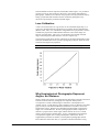
1
Delta-T Devices Ltd
Hemiview User Manual
Notes:
HemiView Manual Revision Number: 2.1
HemiView Manual Copyrights:
Copyright © 1996-1999 Helios Environmental Modelling Institute, LLC
Copyright © 1998-1999 Delta-T Devices, Ltd.
User Manual and On-line Help Authors:
Paul M. Rich, John Wood, David A. Vieglais, Kaz Burek, Nick Webb
Editor: Nick Webb
HemiView Software Copyrights:
WARNING: HemiView is protected by copyright law and international treaties.
Copyright © 1998, 1999 Delta-T Devices Ltd.
Copyright © 1996 The University of Kansas Centre for Research, Inc.
Copyright © 1996 David A. Vieglais
Copyright © 1996-1998 Helios Environmental Modelling Institute, LLC
Acknowledgements:
This software and manual were developed with assistance from the University of Kansas Information Technology
and Telecommunication Centre (ITTC), the Kansas Technology Enterprise Corporation (KTEC), and the Kansas
Biological Survey.
Trademarks
ExcelTM and WindowsTM are trademarks of Microsoft Corporation.
Contact
Delta-T Devices Ltd
128 Low Road , Burwell, Cambridge, CB5 OEJ, UK
Tel: 01638 742922 (international +44 1638 742922)
Fax: 01638 743155 (international +44 1638 743155)
e-mail: [email protected]
Contents
Introduction
1
About this Manual............................................................................................................... 1
Features of HemiView ........................................................................................................ 1
Install HemiView
3
System Requirements.......................................................................................................... 3
Installing or Removing HemiView ..................................................................................... 4
Tutorial 1: Introduction to Hemispherical Photography
5
What is Hemispherical Photography? ................................................................................. 5
Hemispherical Photography as “Upside Down” Remote Sensing ........................ 5
Some Applications of Hemispherical Photography .............................................. 5
Hemispherical Images as Permanent Records of Sky Visibility and Obstruction 6
Brief History of Hemispherical Photography...................................................................... 6
Hemispherical Co-ordinate System..................................................................................... 7
How Are Sky Directions Represented? ................................................................ 7
Lens Calibration.................................................................................................... 9
Why Hemispherical Photographs Represent Angles, Not Distance...................... 9
Basic Steps of Hemispherical Photography ...................................................................... 10
Image Acquisition and Digitisation .................................................................... 10
Classification of Images...................................................................................... 11
Compounding of Errors ...................................................................................... 11
Indices Derived from Hemispherical Photographs............................................................ 14
Gap Fraction ....................................................................................................... 14
Solar Radiation Indices ....................................................................................... 15
The Basic Model for Estimation of Solar Radiation ........................................... 15
Site Factors from Hemispherical Photographs.................................................... 17
Leaf Area Index from Hemispherical Photographs............................................. 17
Analysis of partial images................................................................................... 19
Tutorial 2: Using HemiView
20
Set up your work folders ................................................................................................... 20
Starting HemiView in your Working Directory.................................................. 20
Start up .............................................................................................................................. 21
Toolbars ............................................................................................................................ 21
Standard Toolbar ................................................................................................ 21
View Toolbar ...................................................................................................... 21
Calculate Toolbar................................................................................................ 22
Site List Toolbar ................................................................................................. 22
Lens List Toolbar................................................................................................ 22
Day of Year Toolbar ........................................................................................... 23
Threshold Toolbar.............................................................................................. 23
Solar Models Toolbar ......................................................................................... 23
Output Configuration Toolbar ............................................................................ 23
Open an Image .................................................................................................................. 24
Align Image....................................................................................................................... 26
Overlay Skymap, Sunmap and Daytrack .......................................................................... 29
Hemiview User Manual
Contents • i
Lens Selection ................................................................................................................... 30
Site Properties ................................................................................................................... 31
Solar Model....................................................................................................................... 31
Classify Image................................................................................................................... 32
Inspect Results................................................................................................................... 34
Change Calculation Settings ............................................................................................. 38
Uncorrected ('U', as in DSFU) does not mean horizontal surface!! .................... 40
Calculate Results ............................................................................................................... 41
Using .hvs (HemiView Settings) Files .............................................................................. 43
Learn about .hvs (HemiView Settings) files. ...................................................... 43
Next time you Open an image............................................................................. 43
Calculating Time Series and Sunfleck Duration ............................................................... 45
Tutorial 3: Field Protocols
47
Goal of Photograph Acquisition........................................................................................ 47
Camera System.................................................................................................................. 47
Film ................................................................................................................................... 47
Additional Supplies ........................................................................................................... 47
Self-Levelling Camera Mount........................................................................................... 48
Camera Positioning Equipment......................................................................................... 48
Optional Equipment for Camera Orientation and Location of Photograph Edges ............ 50
Protocol for Image Acquisition ......................................................................................... 50
Field protocol for photograph acquisition:.......................................................... 50
Preparations Prior to Going into the Field......................................................................... 51
Camera Positioning and Orientation ................................................................................. 51
Photograph Exposure .......................................................................................... 51
Taking Photographs ............................................................................................ 51
Use of Camera Databacks ................................................................................... 52
Field Records .................................................................................................................... 52
Weather and Lighting Considerations ............................................................................... 52
Permanent Photograph Sites.............................................................................................. 52
Special Methodology for the Humid Tropics .................................................................... 52
Film Processing ................................................................................................................. 53
Typical Film Processing Protocol ....................................................................... 53
Photograph Archiving ....................................................................................................... 53
Tutorial 4: Case Studies
54
Solar radiation regimes below the canopy......................................................................... 54
Solar radiation regimes and site indices for treefall gaps versus closed-canopy
locations. ............................................................................................................. 54
Solar radiation regimes or site indices as they relate to plant ecophysiology and
growth. ................................................................................................................ 55
Site factors as they relate to habitat suitability for animal species...................... 55
Solar radiation regimes along transects, and soil moisture in heterogeneous
canopies. ............................................................................................................. 55
Vertical transects, and changes in available light with height growth. ............... 56
Using multiple transects to compare spatial patterns in different forest stands. . 56
Two-dimensional maps of solar radiation from arrays of photographs (multiple
transects). ............................................................................................................ 56
Monitoring temporal changes in solar radiation regimes after major disturbance
events. ................................................................................................................. 57
Sunfleck studies................................................................................................................. 57
Using sunfleck regimes as an input to ecophysiological models of plants.......... 57
Solar radiation interception by canopies ........................................................................... 58
Solar radiation interception in forest canopies as it relates to succession. .......... 58
Solar radiation interception in three-dimensional reconstructions of forest
canopies. ............................................................................................................. 58
Recording and analysing structure .................................................................................... 59
Comparison of leaf area index of forest stands. .................................................. 59
ii • Contents
Hemiview User Manual
Challenges and Opportunities ........................................................................................... 59
References......................................................................................................................... 60
Technical Support
68
Contacts............................................................................................................................. 68
On-Line Help ...................................................................................................... 68
Readme.txt .......................................................................................................... 68
www.delta-t.co.uk............................................................................................... 68
Distributor contact .............................................................................................. 68
Before you call.................................................................................................... 68
Direct Delta-T contact......................................................................................... 68
LICENCE.......................................................................................................................... 68
DISCLAIMER .................................................................................................................. 69
CREDITS, COPYRIGHT and NOTICES......................................................................... 70
Glossary of Terms
71
Index
77
Hemiview User Manual
Contents • iii
Introduction
About this Manual
Use this manual to get started with HemiView.
It covers the following
Getting Started:
Installing the software
Tutorial 1: Introduction to Hemispherical Photography – essential
background for understanding and using HemiView effectively.
Tutorial 2: Using the HemiView Software – supplemented by
comprehensive on-line help.
Tutorial 3:
Field Protocols - about good experimental techniques.
Tutorial 4:
Case Studies
Technical Support
Glossary of Terms
In addition to the above, the on-line Help includes sections on
Windows and Menu Commands
Calculations Theory
Files.
Features of HemiView
HemiView is a Windows-based program designed for convenient image analysis
of hemispherical photography.
HemiView supports the following image file formats: Windows or OS/2 BMP (
*.bmp), JPEG ( *.jpg), PC Paintbrush PCX ( *.pcx), TIFF ( *.tif), TARGA (
*.tga) and Photo CD( *.pcd).
Full Windows compatibility enables the user to place digital images and analysis
results in the clipboard and to paste graphics and data directly in documents or
graphics presentations.
Image display toggles between original and classified views, permits real-time
display of negatives as positive images, and provides for overlay of skymaps,
sunmaps, and daytrack maps.
A horizon circle marked with cardinal points and magnetic North, along with an
interactive alignment mode enables precise registration of images with the
hemispherical co-ordinate system.
Hemiview User Manual
Introduction • 1
Interactive image classification allows the user to adjust a threshold intensity
value that distinguishes visible sky from sky obstructions, producing a classified
image. The user can toggle instantaneously between a full colour display of the
canopy photograph and a threshold display of the classified image.
Rapid calculations are made possible by HemiView’s use of advanced
algorithms to calculate gap fraction, contributions of direct and diffuse solar
radiation from each sky direction, site factors, and leaf area index (LAI).
Computation and results output generally require less than one minute on a
Pentium computer. Typically, each image can be analysed in two to five
minutes, including all steps of input, alignment, selection of a threshold,
calculation, and output of results.
The results of analysis are output to a fully functional spreadsheet where they
can be further analysed within the HemiView environment. Alternatively, the
spreadsheet can be saved to disk as an Excel 5.0 compatible workbook for
archiving or further analysis.
A large selection of options for calculated results permits users to custom design
output suited to particular needs.
HemiView is fully configurable, such that a user can specify detailed site and
lens characteristics for use in calculations.
2 • Introduction
Hemiview User Manual
Install HemiView
System Requirements
HemiView runs on 486 and Pentium computers. The following is a listing of
system requirements:
Operating System:
Microsoft Windows NT v.4.0, Windows 95, Windows 98.
Memory (RAM):
Minimum: 16 Mbytes. Recommended: 32 Mbytes of RAM to improve
calculation performance. Larger images require more RAM.
Storage (hard disk):
Minimum: HemiView requires approximately 10 Mbytes of free space for
installation. Recommended: 20 Mbytes to 2 Gbytes. Considerable disk space
can be required for handling images.
Video Display:
Minimum: 16 colour VGA Recommended: 800 x 600 24-bit true colour or 16bit high colour display adapter with hardware accelerated panning. Superior
operation can be achieved with a higher resolution adapter (e.g. 1024 x 768 true
colour).
Other Features:
Mouse, trackball, or other pointer device (required); CD ROM drive (essential);
writeable CD, tape backup, or other mass storage device (optional for archiving
large image files)
Hemiview User Manual
Install HemiView • 3
Installing or Removing HemiView
The HemiView files include a program called Setup.exe which automatically
installs HemiView on your computer. Once installed, a HemiView installation
can be removed by following the simple procedure described below.
Installing HemiView
To run the installation program Setup.exe, which is provided on the HemiView
distribution CD, do the following:
1. Start Windows. Insert the HemiView CD in an appropriate drive.
2. From the Start Menu, select Settings, Control Panel.
3. In Control Panel, double click on AddorRemove Programs.
4. In the Install/Uninstall tab, click the Install button and follow the on-screen
instructions.
You will be prompted to enter the serial number. This can be found on the
HemiView CD.
Uninstalling HemiView
To uninstall Hemiview:
1. From the Start Menu, select Settings, Control Panel.
2. In Control Panel, double click on Add/Remove Programs.
3.
4 • Install HemiView
In the Install/Uninstall tab, highlight HemiView in the list of installed
programs, click the Add/Remove button and follow the on-screen
instructions.
Hemiview User Manual
Tutorial 1: Introduction to
Hemispherical Photography
What is Hemispherical Photography?
Hemispherical photography provides an upward-looking view of all or part of
the sky. Typically hemispherical images are acquired with either a standard film
camera or a digital camera fitted with a hemispherical (fisheye) lens pointed
upward. The resulting photographs provide a permanent record that can be
analysed to determine which parts of the sky are visible and which parts are
obstructed by landscape features, plant canopies, or human-built structures.
Based on these measurements of the geometry of sky visibility and sky
obstruction, hemispherical photographs can be used to calculate solar radiation
regimes and plant canopy characteristics such as Leaf Area Index (LAI).
Hemispherical photography can greatly expand the number of field sample
measurements that are possible as compared with direct solar radiation sensor
measurements or direct leaf area measurements. Computer analysis with
HemiView, involving advanced digital image analysis techniques, enables
efficient analysis of large numbers of photographs.
Hemispherical Photography as “Upside Down”
Remote Sensing
Hemispherical photography can be thought of as “upside down” remote sensing.
Hemispherical photographs can be analysed by hand or automated digital image
analysis to precisely measure geometry and its implications. Once properly
classified, hemispherical photographs literally provide a detailed map of sky
visibility and obstruction. In turn, solar radiation regimes and canopy
characteristics can be inferred from this map of sky geometry. In the case of
plant canopies, a hemispherical photograph can be interpreted as a map of the
directions of canopy openings relative to the location from which the photograph
is taken. They can be inspected to provide insight into heterogeneity within a
given canopy and to compare canopies at different sites.
Some Applications of Hemispherical
Photography
Herein the term hemispherical photograph is used to refer to any extremely
wide-angle, upward-looking image, generally with a 180-degree field of view,
whether it is obtained from a film camera, a digital camera, or from a theoretical
model. While this manual tends to emphasise using hemispherical photography
to analyse plant canopies, and in particular forest canopies, the same principles
apply for many other uses. For example, hemispherical photography can be used
to analyse the influence of human structures such as buildings, to analyse the
influence of topographic features such as mountains, or even to analyse the
Hemiview User Manual
Tutorial 1: Introduction to Hemispherical Photography • 5
influence of window placement within a room inside a building. Applications
can be classified into two main categories:
environmental monitoring, modelling, and research for agriculture, forestry,
micrometeorology, ecology, environmental science, and remote sensing;
design and site evaluation for architecture, planning, and engineering;
Hemispherical Images as Permanent Records of
Sky Visibility and Obstruction
Hemispherical photographs provide a permanent record of the geometry of sky
visibility and obstruction. Hemispherical photographs can be stored as negatives
or transparencies, and/or as digital images. Film media have distinct advantages
of relatively low cost and high resolution. Recent advances in digitisation
methodology and storage devices, along with decreasing storage media costs
now make it practical to create digital archives of hemispherical photographs.
New technology (e.g. Kodak PhotoCD) provides a convenient, low-cost means
for producing digital archives. As permanent records, hemispherical
photographs can be studied using existing analytical methodology and saved for
future study. Analogous to the way voucher specimens are collected for
vegetation or floristic studies, hemispherical photographs can be collected and
archived for comparative study of plant canopies.
Brief History of Hemispherical Photography
Hill (1924) first designed the hemispherical (fisheye) lens for view of the whole
sky to study cloud formation. Later, architects used hemispherical photographs
to assess “site factors” that estimate the solar radiation regimes at different
positions within or near buildings. Foresters and forest ecologists conceived of
using photographic techniques to study the light environment under forest
canopies. In particular, Evans and Coombe (1959) estimated solar radiation
penetration through forest canopy openings by overlaying diagrams of the sun
track on hemispherical photographs. Anderson (1964, 1971) provided a
thorough theoretical treatment for calculating the penetration of solar beam
(direct) and scattered (diffuse or indirect) components of solar radiation from
visible sky directions as determined using hemispherical photographs.
In recent years, many researchers have successfully used hemispherical
photography to study solar radiation regimes and plant canopy architecture (see
reviews in Chazdon and Field 1987, Rich 1988, 1989, Becker et al. 1989).
Detailed treatments of field and analytical methodology have been provided by
Pearcy (1989) and Rich (1989).
Until relatively recently, interpretation of hemispherical imagery has required
tedious manual analysis using sampling grids. Jupp et al. (1980) first developed
a computer program, PISCES, for analysis of hemispherical photographs, but
Pisces still required manual photograph analysis and data entry. Automated
image analysis was attempted by various researchers (Bonhomme and Chartier
1972, Olsson et al. 1982, Chan et al. 1986). Chazdon and Field (1987)
developed a microcomputer analysis system, SOLARCALC, based on the Apple
Macintosh. Integrated image analysis systems based on DOS computers, in
particular the systems CANOPY (Rich 1988) and SYLVA (Becker et al. 1989),
were developed to use video for direct input of negatives. Most recently several
Windows-based software packages have been developed, for example the
program HEMISP (Vieglais unpublished).
HemiView benefits from and has many advantages over these prototype systems.
These advantages include full Windows compatibility, lack of requirement for
expensive specialised hardware, support of a full spectrum of standard image
6 • Tutorial 1: Introduction to Hemispherical Photography
Hemiview User Manual
formats, rapid and accurate calculation, configurable output to spreadsheets,
flexibility for incorporating site-specific information, expert technical support,
and ongoing commitment to the research and development required for
improvements and new capabilities.
Hemispherical Co-ordinate System
How Are Sky Directions Represented?
Hemispherical Viewsheds
Hemispherical photographs provide a hemispherical field of view, which, when
looking directly upwards, corresponds to a “viewshed” of all sky directions.
This hemispherical viewshed can be represented as an image by projecting the
hemisphere of directions on a plane. Each position of the image corresponds to a
sky direction. Sky directions are represented by two angles: the zenith angle θ
(angle relative to the zenith) and the azimuth angle α (angle relative to true
north). As its standard reference, HemiView uses an equiangular projection for a
full 180-degree field of view.
Hemispherical Projections
The resulting circular image (looking upward from beneath the hemisphere
shown above) gives a complete view of all sky directions, with the zenith in the
centre of the image and the horizons at the edges.
Hemiview User Manual
Tutorial 1: Introduction to Hemispherical Photography • 7
The hemispherical image above was taken in a treefall gap in the tropical rain
forest of Costa Rica. Note that north is toward the top of the image, south
toward the bottom, east toward the left, and west toward the right. East and west
are reversed from the usual convention in maps because the view is upward
rather than downward.
Equiangular Projections
In an equiangular projection, the zenith angle (the angle between the zenith and a
given sky location) is directly proportional to the distance along a radial axis
within the image.
Other Hemispherical Lens Projections
More generally, any hemispherical lens produces an image in which the zenith is
in the centre of the image, the maximum view angle is at the edges of the image,
8 • Tutorial 1: Introduction to Hemispherical Photography
Hemiview User Manual
and intermediate locations represent intermediate zenith angles. It is possible to
precisely locate any intervening sky direction in the resulting hemispherical
photographs. HemiView accounts for the projection used by a particular lens by
fitting a polynomial that translates location within the photograph to sky
direction (represented by zenith and azimuth angle).
Lens Calibration
A lens correction function for a given lens can be calculated empirically or, in
some cases, determined from specifications provided by the lens manufacturer
(Herbert 1986, 1987). For calculations using HemiView a polynomial is used to
calculate the proportion of radial distance from the centre of the image as a
function of zenith angle. The curve is constrained to pass through 0 and 90
degree zenith angles at radial distances of 0 and 1 respectively.
The following graph shows the lens calibration for the Sigma hemispherical lens.
Note that the dotted line shows a perfect equiangular projection, while the solid
line shows the Sigma lens projection.
Note: The HemiView lens equations are expressed in radians not degrees
Why Hemispherical Photographs Represent
Angles, Not Distance
Simply stated, each position in a hemispherical photograph represents a direction
from the location where the photograph was acquired. Each position
corresponds to a zenith, azimuth angle co-ordinate in a hemispherical coordinate system. Actual distance, such as heights of trees or diameters of treefall
gaps can only be calculated if additional information is available, such as the
height of the canopy. Distance in a hemispherical photograph corresponds to
angles, not to actual distance. Within a photograph, the radial component of
distance is proportional to zenith angle, and the distance in an arc at a fixed
radius is proportional to azimuth angle. Area in a hemispherical photograph
corresponds to angular area or along a hemisphere of directions. With
supplementary measures of distance, or hemispherical photographs taken at
known distances from each other, it is possible to determine distances using
Hemiview User Manual
Tutorial 1: Introduction to Hemispherical Photography • 9
standard trigonometry. Note how two canopies of different heights can have
similar angles of openings, as shown below.
Basic Steps of Hemispherical Photography
The three basic steps of digital image analysis of hemispherical photography are
image acquisition, digitisation, and analysis:
Image acquisition typically involves taking hemispherical photographs using a
film camera looking upward from a location of interest (e.g. from beneath a plant
canopy). Images may also be “acquired” by calculation using a simulation
model that accounts for three-dimensional geometry.
Image digitisation typically involves conversion of a film photograph (an
analogue format) into digital format. In the case of HemiView, film negatives
can be digitised using a negative scanner, a video framegrabber, or other
analogue to digital conversion device. In the case of digital cameras or video
cameras connected to a framegrabber, image acquisition and digitisation are
combined into one step, the analogue to digital conversion occurring at the time
the image is acquired.
Image analysis involves four steps:
1. classification of images to distinguish visible and obscured sky directions
(e.g. for canopies, to distinguish canopy openings from foliage);
2. calculation of sky visibility and obstruction as a function of sky direction;
3. calculation of solar radiation and/or canopy indices using this information
about sky visibility and obstruction;
4. output of results.
Image Acquisition and Digitisation
Typically hemispherical photographs are acquired through standard film cameras
and then negatives or positives are digitised using scanners, video digitizers, or
other analogue to digital conversion technologies. Recently digital cameras
present the possibilities to combine acquisition and digitisation in one step.
A primary challenge in image acquisitions is to obtain high contrast images with
excellent distinction between visible sky and obscured sky directions. Another
challenge is to ensure that the camera is properly oriented, such that the axis of
the lens is pointed directly upward and the camera is oriented with magnetic
north in a known direction.
See "
10 • Tutorial 1: Introduction to Hemispherical Photography
Hemiview User Manual
Tutorial 3: Field Protocols" on page 47.
Classification of Images
Classification of images involves using digital image processing to distinguish
visible and obscured sky directions. In the case of plant canopies this means
distinguishing canopy opening from foliage.
Threshold Method
Use of a threshold algorithm is one of the simplest and most effective means for
classifying an image. Classification is achieved by determining a threshold
intensity value, above which is classified as visible, and below which is
classified as obscured. This technique is also known as segmenting an image, in
that it divides a set of grey levels (intensity values) into a binary classification.
The technique has the advantage that it is relatively simple to understand and
use, but has problems that can result because of unevenness in the light
conditions within images.
Successful classification depends upon having high contrast photographs in
which foliage or other sky obstruction is consistently darker than visible sky
directions. Problems arise if parts of the visible sky are darker than obscured sky
directions (for example, dark clouds) or if parts of the obscured directions are
brighter than the visible sky (for example, reflections on leaves). In practice, for
canopies the technique involves a compromise between overestimating large
areas of visible sky (large canopy openings) near the zenith and underestimating
small areas of visible sky (small canopy openings) near the horizon. Within
reason, images can be edited to compensate for dark sky regions or bright
obscured regions using commercial image editing software such as the Paint
program provided with Windows 95. This typically involves manually changing
values for regions of an image and using flood routines to assist in classifying
problematic portions of images.
In HemiView thresholds are determined interactively, such that a user can
instantaneously toggle back and forth between the threshold display and a
continuous tone display, while increasing or decreasing the threshold value until
edges of the classified image best match visible or obscured sky edges of the
continuous tone image. Subjectivity in the choice of thresholds is minimised by
adopting strict protocols for deciding thresholds, by practice, and by use of high
contrast images taken under even lighting conditions.
Other Methods
Other methods for image classification are various, and include the following.
These are not provided by HemiView:
- modified threshold techniques that produce local thresholds for different
portions of an image;
- modified threshold techniques that account for systematic differences in
lighting conditions within different parts of the image (in particular brighter
lighting in the centre as opposed to the edges);
- colour techniques, that use colour indices and/or advanced lookup table
algorithms to classify images.
Compounding of Errors
For hemispherical photography, errors can occur at any stage of image
acquisition, digitisation, or analysis. Because many steps are involved,
accumulated error can become great unless strict quality control is exercised. A
severe error at any stage can invalidate the final results, even if other steps are
Hemiview User Manual
Tutorial 1: Introduction to Hemispherical Photography • 11
performed with little error. Strict protocols should be developed and followed to
prevent cumulative errors.
Sources of Error in Hemispherical Photography:
Camera position:
- horizontal and vertical position
- film plane levelling
- azimuth rotation
The degree of alignment accuracy required can be quite complicated to predict
and depends on the application. The following can is intended be used as a rough
guide.
For LAI, site factors and global measurements the effect of 1 degree out from
level or North alignment are going to be pretty small. Cosine corrections will be
in error determined by the number of degrees out of level, and that part of the
image below the horizon will not be measured or will be measured incorrectly.
If you are studying sunflecks and trying match predicted and actual sunfleck
patterns on a particular day then you have to be very accuratelty aligned. If your
alignment is out by the equivalent of one solar disk ( half a degeree ) then you
will be in error for the calculated times and position of the sunfleck. In practice
it is quite difficult to achieve half a degree accuracy in horizontal aligment, and
so you should be as careful as possible.
The main point to remember is that you need a higher alignment accuracy for
accurate sunfleck predictions than for for broad global meaurements such as
LAI, site factors and gap fractions.
Exposure:
- sky lighting evenness
- foliage lighting evenness.
Reflections can occur if the sun is lighting-up the underneath of some of the
leaves. This is one reason for taking pictures when the sun is just below the
horizon. Glossy leaves can give reflections from bright portions of sky even
when the direct sun is not visible.
Optical distortion
To a large extent Hemiview takes out optical distortions for the recommended
lenses.
Image quality, resolution and digitisation
For a given image, the highest achievable resolution and colour depth are best.
Digitising film will add some noise and lose resolution, but even so, good quality
35 mm film combined with the use of a high resolution scanner can be better
than a lower resolution digital camera. This must be balanced against the benefit
of real-time feedback from the use of digital cameras.
Alignment with co-ordinate system:
- horizon circle size
- x,y translation of horizon circle
- rotation relative to North
The error considerations are similar to those mentioned above for aligning the
camera. The accurate registration of the horizon circle on screen requires some
care.
Image Analysis:
- classification—distinguishing visible sky from obscured sky
- image editing/enhancement
- calculation assumptions.
12 • Tutorial 1: Introduction to Hemispherical Photography
Hemiview User Manual
The interactions between all sources of error are complicated and so it is not
possible to give guidance on accuracy requirements for individual applications.
Hemiview User Manual
Tutorial 1: Introduction to Hemispherical Photography • 13
Indices Derived from Hemispherical Photographs
Hemispherical photographs can be analysed to derive a variety of useful indices:
geometric indices of visible sky and sky obstruction, in particular gap fraction
as a function of sky direction;
solar radiation indices based on geometry and fundamental physical properties
of solar radiation;
canopy indices such as leaf area index (LAI).
Gap Fraction
What is Gap Fraction?
Gap fraction is the proportion of visible sky within a given sky sector, where a
sky sector is defined by a range of zenith and azimuth angles. All calculations,
whether for solar radiation regimes or for canopy characterisation, ultimately
depend upon dividing the sky into sectors and calculating gap fraction for each
sky sector. A gap fraction of zero (0) means that the sky is completely blocked
(obscured) in that sky sector. A gap fraction of one (1) means that the sky is
completely visible (not obscured) in that sky sector.
Gap Fraction for the Sunmap
Gap fraction along the path of the sun is derived by overlaying a series of solar
tracks to produce a Sunmap of sky sectors defined by time of day and day of
year and calculating the proportion of sky visible in each sky sector:
Gap Fraction for the Skymap
Gap fraction for any sky direction is derived by overlaying a grid of sky sectors
defined by zenith and azimuth angle ranges to produce a Skymap and calculating
the proportion of sky visible in each sky sector:
What do the Skymap and Sunmap represent
14 • Tutorial 1: Introduction to Hemispherical Photography
Hemiview User Manual
Although the Sunmap and Skymap are similar overlays, they have some
important differences when used by Hemiview, especially for calculating
radiation values.
The Skymap divides the hemiphoto into areas representing different directions,
so shows variations in space. When combined with the incident diffuse radiation,
it shows how the available diffuse light varies in space, and can be applied to
either instantaneous radiation values, or values integrated over some time
interval.
The Sunmap matches the track of the sun throughout the day, and through the
year, so it divides the hemiphoto into areas representing time. When combined
with incident direct radiation values it shows how direct radiation varies over
time.
It is because of these differences that the Sunmap and Skymap use different units
when radiation values are calculated.
Solar Radiation Indices
What are the Main Types of Solar Radiation?
Incoming solar radiation (insolation) can potentially originate from a visible
sky direction as either of two types:
direct radiation – radiation passing unimpeded through the atmosphere from
the sun; and
diffuse radiation – solar radiation that is scattered by the atmosphere.
One consequence of having visible sky in a given direction is that direct and
diffuse solar radiation can pass unimpeded from that direction. On the other
hand, obscured sky directions represent directions where solar radiation can not
be transmitted directly, however reflected radiation can originate from canopy
elements in those directions. Global radiation is defined as the sum of direct,
diffuse, and reflected radiation reaching a particular location. Under most
circumstances, the majority of insolation reaching a given location originates as
direct or diffuse solar radiation transmitted from visible sky directions, as
opposed to reflected radiation from surfaces in obscured sky directions.
Direct radiation for a particular site depends upon the relative position of the sun
as it changes through the day and through the year, as well as upon atmospheric
conditions. Diffuse radiation for a particular site depends upon the amount of
incoming radiation that scatters from each sky direction. For any given period of
time, global radiation reaching a location under a plant canopy is defined within
HemiView as the sum of direct and diffuse radiation entering through canopy
openings, and does not include reflected radiation off of surfaces in obscured sky
directions. Analyses of hemispherical photographs commonly use indices
expressed as the proportion of direct or diffuse solar radiation for a given
location, relative to that in the open, known as direct and diffuse site factors
respectively.
The Basic Model for Estimation of Solar
Radiation
A reasonable estimate of radiation from direct radiation can be obtained by
looking at the intersection between visible sky directions and the amount of
direct radiation that can be expected from those sky directions. Similarly, a
reasonable estimate of radiation from diffuse radiation can be obtained by
looking at the intersection between visible sky directions and the amount of
diffuse radiation that can be expected from those sky directions.
Hemiview User Manual
Tutorial 1: Introduction to Hemispherical Photography • 15
In this basic model, as viewed from beneath a plant canopy, foliage absolutely
blocks incoming radiation and canopy openings allow radiation to pass
unimpeded. Radiation reflected by or transmitted through foliage is ignored.
Direct radiation is calculated by multiplying the gap fraction of a sunmap sector
by the radiation originating from that sky sector, and correcting for angle of
incidence. Similarly, diffuse radiation is calculated by multiplying the gap
fraction of a skymap sector by the radiation originating from that sky sector, and
correcting for the angle of incidence.
What is Angle of Incidence?
The angle of incidence is the angle between a surface and incoming radiation
reaching the surface, measured relative to the direction normal to the surface.
The amount of radiation reaching the surface is proportional to the cosine of the
angle of incidence. Thus radiation originating at a right angle to the surface has
an angle of incidence equal to zero, a cosine of one, and receives the full amount
of radiation; whereas radiation originating parallel to a surface has an angle of
incidence of 90-degrees, a cosine of zero, and receives no radiation from that
direction. HemiView accounts for angle of incidence by multiplying radiation
originating from each sky sector (diffuse or direct) by the cosine of the angle of
incidence from the centroid of the sky sector to the surface.
Within HemiView, the intercepting surface can be set to any orientation. It
would typically be set to horizontal (Zenith = 0, Azimuth = 0) to give results
comparable to measurements made with levelled cosine-corrected sensors.
However there are cases, e.g. modelling the response of individual leaves, where
it is appropriate to set the intercepting surface to the same orientation as the
surface being studied.
What are the Units of Solar Radiation?
Solar radiation flux can be variously expressed, in terms of energy flux or in
terms of Photon Flux Density (PFD):
Energy flux is commonly measured in units of megajoules per square meter per
second (MJm-2s-1).
PFD is commonly measured in micromoles per square meter per second (µmol
m-2sec-1). These are also known as microEinsteins (µE)
PAR and Other Wavelengths of Interest
For study of energy balance, it is common to study all wavelengths of solar
radiation, termed total radiation. For study of plant ecophysiology, especially
when studying processes of light interception for photosynthesis, it is useful to
measure photosynthetically active radiation (PAR), those wavelengths that are
active in photosynthesis (400-700 nm). PAR flux is referred to as
photosynthetic photon flux density (PPFD).
Site-Specific Solar Radiation Values
Considerable variation in solar radiation regimes occurs between sites, even at
the same latitude. Further, energy flux, PFD for total radiation, and PPFD are
not always linearly proportional. Site-specific distributions of diffuse and direct
radiation can be formulated accordingly using empirical or theoretical insolation
values appropriate for a particular site. Long-term monitoring of direct and
diffuse radiation for a given site can be accomplished using pyranometers (for
total radiation) or quantum sensors (for PAR) attached to data loggers. For
detailed studies, two sensors are required, one to monitor global radiation flux
and a second to monitor diffuse radiation. The diffuse radiation sensor must be
fitted with a shadowband to block radiation along the sun path. Direct radiation
is calculated as the difference between observed global radiation flux and diffuse
radiation flux. The Delta-T BF2 Sunshine Sensor has been designed specifically
for this purpose.
16 • Tutorial 1: Introduction to Hemispherical Photography
Hemiview User Manual
Site Factors from Hemispherical Photographs
What are Site Factors?
Site factors are indices of the proportion of radiation reaching a given location.
Values range from 0 to 1, with 0 being no radiation (complete sky obstruction)
and 1 being the radiation for an open location (complete sky visibility = no sky
obstruction).
Indirect site factor (ISF) is the proportion of diffuse solar radiation reaching a
given location, relative to a location with no sky obstructions (“diffuse site
factor” of Anderson 1964).
Direct site factor (DSF) is the proportion of direct solar radiation reaching a
given location, relative to that in a location with no sky obstructions.
Global site factor (GSF) is the proportion of global radiation (direct plus
diffuse) under a plant canopy relative to that in the open (“total site factor” of
Anderson 1964).
ISF and DSF can readily be estimated from canopy photographs, given
assumptions about the contribution of diffuse and direct radiation from each sky
sector. GSF can be estimated if we have an estimate of the relative proportions
of diffuse and direct radiation in the open, either determined empirically or
theoretically.
Converting Site Factors to Energy Flux, PFD, or PPFD
ISF, DSF, and GSF can be considered to be proportional estimates of energy
flux, PFD for total radiation, or PPFD, and can be translated to absolute levels of
radiation flux for a particular period of time by multiplying by the appropriate
radiation values measured in the open for the site.
Leaf Area Index from Hemispherical
Photographs
What is Leaf Area Index?
Leaf area index (LAI) is widely used to describe the photosynthetic and
transpirational surface of plant canopies. LAI can be simply defined as the
amount of leaf surface area per unit ground area, and has broad applications in
ecophysiology, water balance modelling, and characterisation of vegetationatmosphere interactions. In recent years, many researchers have adopted the
definition of LAI as half of the total leaf area per unit ground surface area (Lang
et al. 1991 and Chen and Black 1992), as opposed to the projected area, which
does not work well for all leaf shapes.
Hemiview algorithms will estimate LAI as half of the total leaf area per unit
ground area.
LAI Models
Inversion Models
Calculation of LAI involves use of Beer’s Law, which can be expressed as
follows:
G(θ) = e –K(θ).L
where:
G is gap fraction,
K(θ) is the extinction coefficient at angle θ, and
L is LAI, θ is zenith angle.
Hemiview User Manual
Tutorial 1: Introduction to Hemispherical Photography • 17
Calculation of LAI involves a kind of iterative “inversion” model, whereby LAI
is inferred from the observed distribution of gap fraction as a function of zenith
angle. These models are termed inversion models because they work backwards,
in that instead of inferring a pattern of gap fraction resulting from a particular
distribution of leaves in a canopy they infer the pattern of leaf distribution from
the pattern of gap fraction. While the former (forward) model can be solved
analytically, the latter (inverted) model requires an iteration of approximate
solutions that converge upon a satisfactory solution.
Assumptions of LAI Models
Calculations of LAI assume a random distribution of canopy elements, such that
gap fraction should be observed for a small enough annulus that randomness can
be assumed. LAI calculated in this manner is sometimes termed “effective LAI”
(LAIeff), since it does not account for non-random distribution of foliage. Chen
et al. (1991) suggests that a clumping factor can be used to account for this nonrandom distribution, such that LAIeff is simply multiplied by a stand-specific
clumping factor to calculate a more realistic LAI. In practice, LAI and LAIeff are
nearly identical in broadleaf canopies (i.e., clumping factors are near unity);
however, in conifer canopies, where there is strong clumping, it becomes
necessary to estimate the clumping factor by either direct of indirect means
(Chen and Cihlar 1995, Chen et al. 1995).
The LAI estimated by the inversion process may not be an exact measure of the
LAI of the real canopy, even if that could be measured accurately. However, an
ideal canopy with the LAI estimated will behave in a very similar way to the real
canopy as far as radiation interception is concerned.
Leaf Angle Distribution
The same models that permit calculation of LAI also permit calculation of leaf
angle distribution. Leaf angle distribution refers to the distribution of LAI
between leaves of each angular orientation.
18 • Tutorial 1: Introduction to Hemispherical Photography
Hemiview User Manual
HemiView LAI Calculations
Introduction
a
b
Campbell(1986) derived an equation for the extinction coefficient of canopy
elements distributed in the same proportions and orientation as the surface of an
ellipsoid of revolution, symmetrical about a vertical axis. The semi vertical axis
is a and the semi horizontal axis is b . There is symmetry about the vertical axis.
He relates these to a single parameter x=b/a. (x is the Ellipsoidal Leaf Angle
Distribution Parameter, or ELADP). The extinction coefficient also depends on
the zenith angle of the incoming direct beam. Canopy elements are assumed to
be completely black, and randomly distributed in a horizontal slab extending to
infinity in all directions. This model can be used to represent a wide variety of
different canopies by choosing an appropriate LAI and ELADP. An ELADP
greater than 1 represents a canopy where the elements are predominantly
horizontal, and less than 1 represents a canopy where the elements are
predominantly vertical.
Hemiview LAI Inversion
Hemiview finds the values of LAI and ELADP for an ellipsoidally distributed
theoretical canopy that give the best fit to the measured gap fraction values from
the hemiphoto. These best fit values are then used as a basis for subsequent
calculations in the LAI group. This gives a robust and widely applicable result,
but will not necessarily accurately reflect particular cases, such as bimodal
distributions (where the canopy is a mix of two very different types of canopy
element).
HemiView estimates the effective LAI, so this value may need to be multiplied
by a clumping factor to give an accurate estimate of actual LAI.
Analysis of partial images
There are situations where users may wish to ignore part of an image from the
analysis, e.g. if the horizon is not entirely within the image area, or part of a
building or crane is visible, or to exclude trunks and branches from a LAI
estimate. Hemiview allows you to paint parts of an image in a colour which is
then ignored by the hemiphoto analysis. Areas ignored in this way can be
visualised as an additional mask between the sky hemisphere and HemiView.
Gap fractions, site factors and LAI are calculated using only the information in
the valid part of the image. Radiation values, both above and below the canopy,
are reduced by the amounts that would have come from the ignored areas.
Hemiview User Manual
Tutorial 1: Introduction to Hemispherical Photography • 19
Tutorial 2: Using HemiView
Set up your work folders
The HemiView installation program creates a directory named Samples under
the HemiView installation directory, and a Windows shortcut which will start up
HemiView in the Samples directory.
The Samples directory contains the files you will need for this tutorial. Two of
them are image files: Sample1.jpg, and Sample2.jpg.
There is also a third file in your Sample folder, called Sample2.hvs. This is not
an image file. Later in the Tutorial you will be asked to load it. It is a
‘HemiView Settings’ file created by using the File, Save command. It contains
information about the Sample2.jpg image file, but does not actually contain a
copy of the image itself.
A point to remember when organising your work folders: HemiView always
needs the image file to be available in the same folder as the .hvs file.
Starting HemiView in your Working Directory
When you are working on “real projects” it is good practice to create a working
directory on your hard drive for your work. That is, keep your data separate from
the actual HemiView program.
You will probably want to create or modify a HemiView icon which starts up
HemiView in your working directory.
1. Highlight the HemiView icon and click the right mouse button to display the
icon’s popup menu.
2. From the popup menu select Properties.
3. Select the Shortcut tab, and enter the name of your working directory in the
Start In box.
20 • Tutorial 2: Using HemiView
Hemiview User Manual
Start up
HemiView can also be started
by double clicking a .hvs file,
in Windows Explorer or
dragging and dropping an
image, .hvs or .xls file icon
onto a HemiView icon (or its
shortcut) icon
Start HemiView either by choosing HemiView in the Start, Programs Menu
or by double-clicking on a desktop shortcut to HemiView.
Toolbars
Toolbars provide quick mouse access to many tools used in HemiView.
Typically toolbars are displayed across the top of the application window, below
the menu bar. Toolbars can also be moved by dragging the border of the toolbar
to the desired location while holding down the left mouse button.
To display or hide toolbars, choose View, Toolbar and click toolbars to be
displayed or hidden. A check mark or tick appears next to each toolbar that is
displayed.
Standard Toolbar
Contains buttons for file management, editing, printing and help:
New – create a new workbook (menu command: File, New).
Open an existing workbook or image. HemiView displays the Open
dialog box, in which you can locate and open the desired file (menu
command: File, Open).
Save the active image or workbook with its current name. If you have
not named the document, HemiView displays the Save As dialog box
(menu command: File, Save).
Cut highlighted cells from the workbook and store it on the clipboard
(menu command: Edit, Cut).
Copy the image or highlighted workbook cells to the clipboard (menu
command: Edit, Copy).
Paste the contents of the clipboard into a workbook at the insertion
point (menu command: Edit, Paste).
Print the active workbook or image (menu command: File, Print).
About HemiView. Displays version number, your serial number,
license and copyright information.
What's This? Displays context sensitive help about the program area
under the mouse when you click the left mouse button.
View Toolbar
Contains buttons for controlling the display of images:
Hemiview User Manual
Tutorial 2: Using HemiView • 21
Toggle the displayed Image on and off (menu command: View,
Show Image).
Toggle between Negative and normal images display (menu
command: View, Negative).
Toggle between Classified and full colour image display ( menu
command: View Classified).
Toggle the Skymap overlay on or off (menu command: View,
Skymap).
Toggle the Sunmap overlay on or off (menu command: View,
Sunmap).
Toggle the Daytrack overlay on or off (menu command: View,
Daytrack).
Toggle the Alignment overlay on or off (menu command: View,
Alignment).
Calculate Toolbar
Contains buttons for working with calculations:
Calculate results using the selected image, current alignment, and
other settings.ns, fcheck you have an image open and selected.
Toggle between the Image and an associated Workbook (menu
command: Window, Image and Window, Workbook).
Site List Toolbar
Typical view of Site List toolbar:
The Site List toolbar allows you to select a site for the image in image window
provided that image window is active (menu command: Settings, Site,
Select).
Click on the toolbar with the right mouse button to bring up a menu which
allows you to add and delete sites to the site list, and to examine and modify the
properties of the current site.
Lens List Toolbar
Typical view of Lens List toolbar:
The Lens List toolbar allows you to select a lens name from the list of available
lenses (menu command: Settings, Lens, Select).
Click on the toolbar with the right mouse button to bring up a menu to examine
and change lens properties.
22 • Tutorial 2: Using HemiView
Hemiview User Manual
Day of Year Toolbar
Typical view of the Day of Year toolbar:
The Day of Year toolbar allows you to select an active day of year for drawing
daytracks and performing time series or sunfleck calculations (menu command:
Settings, DayTrack tab).
Drag the slider, or click the up or down buttons, or type a Day of Year value
directly into the edit box.
The day is part of the current output configuration, so using the Day of Year
toolbar modifies the current output configuration.
Threshold Toolbar
Typical view of the Threshold toolbar:
The Threshold toolbar allows you to decrease or increase the classification
threshold for the active image (menu command: Settings, Classifier).
Alternatively you can click the up or down buttons, or type a threshold value
directly into the edit box.
Whenever the active window is an image window, you can also use the + and –
shortcut keys to change the threshold. Hold down Ctrl and press + or – to
change the threshold in larger steps.
Solar Models Toolbar
Typical view of the Solar Models toolbar.
The Solar Models toolbar allows you to select a choice of solar models
representing the transmission of solar radiation through the earth's atmosphere.
These can be edited and inspected in detail via the menu command Settings,
Solar Model.
Output Configuration Toolbar
Typical view of the Output Configuration Toolbar
The Output Configuration Toolbar allows you to select from a predetermined list
of Output Configurations, each of which may represent a different combination
of calculation settings and Output Sheets. These may be inspected in detail and
edited via the menu command Settings, Output Configuration.
Hemiview User Manual
Tutorial 2: Using HemiView • 23
Open an Image
HemiView can handle several standard image file formats. Choose File, Open.
Select the file Sample1.jpg from the Samples directory (under the HemiView
installation directory) and open it. (This is a greyscale image from a JPEG
format file scanned in from a 35 mm black and white film.)
The image opens in its own image window.
Sample1.jpg also showing a pop-up menu enabled by clicking right mouse button.
Observe that various toolbars have now become available for the display and
analysis of images.
Reduce the size of the image window. Try reducing the image down to an icon.
Enlarge the image window to fill the entire available area.
Right click somewhere on the image and observe the pop-up menu appear, as
shown above. This pop-up menu duplicates some of the commands in the main
menu, and also shows shortcut keys as follows.
24 • Tutorial 2: Using HemiView
Negative
N
Classified:
C
Alignment:
A
Skymap:
K
Sunmap:
U
Daytrack:
D
Hemiview User Manual
The visible sky in this image is fairly uniform. Later in this tutorial, when you
come to "classify" the image by setting a threshold grey scale level representing
the boundary between clear and obstructed sky, you will need the sky
illumination to be as uniform as possible. When classifying the image you will
not want large variations in brightness in the sky, and so you particularly will not
want to see the sun in the photo! The problem is that an obstruction, such as a
leaf, in bright sunlight in one part of the sky may appear brighter than a dull part
of the visible sky somewhere else.
The best time to take pictures is before sunrise or after sunset or on a day when
the sky is uniformly overcast with cloud.
Move the mouse pointer over the image and observe the values changing in the
Status Bar at the bottom of the window:
The status bar presents detailed information about each pixel under the pointer.
•
XY: X,Y co-ordinate of the cursor ( shown as 194,135 pixels from the top
left of the picture).
•
AZ: azimuth and zenith angle co-ordinates, in degrees.
•
RGB: Red, Green, Blue intensity value ( 0,0,0 is black, 255,0,0 is bright
red, 255,255,255 is white), plus an indication of whether the pixel, when
classified, represents obscured (OBS) or visible (VIS) or ignored (IGN)
sky.
Display the Sunmap and move the pointer over it.
•
If the pointer is over over a section of the sky covered by the sunmap, then a
date and time is displayed representing the time of year when the sun would
appear at that location. Of the two times in the year when the sun will
appear at each location, the date and time is shown for the half-year which
contains the day of year shown in the Day of Year toolbar.
Next we need to align the image.
Hemiview User Manual
Tutorial 2: Using HemiView • 25
Align Image
It is necessary to align the image with the hemispherical co-ordinate system, so
that HemiView knows where to find North and the horizon. This is all needed
for the calculations.
The alignment overlay shows the location and geographic orientation of the
horizon circle.
1. Turn the alignment overlay on. There are several ways of doing this:
•
Press the A shortcut key.
•
Right click on the image and left click on Alignment in the pop up menu.
•
Click on the toolbar button
•
Select the View, Alignment command.
Alignment overlay, as it might appear before aligning. It shows the horizon circle, with
the four cardinal points N,S,E & W and the magnetic North symbol - next to the pointer at
about 10 o'clock. The LEDs are clearly visible at 12 and 6 o'clock. The digits at bottom
right, added by the camera can be very useful for identifying pictures.
The actual horizon is defined as a circle at the 90 degree zenith angle.
The alignment overlay shows a horizon circle marked with the four compass
directions ( N, E, S & W) and a compass needle indicating magnetic north.
Note that East is to the left of North and West to the right in hemispherical
photographs, since they are taken looking upward.
If you cannot see the alignment overlay it may simply be the wrong colour.
To change the colour of the horizon circle:
a) Select the menu command Settings, Appearance
b) In the Appearance tab click on Alignment
c) In the Color dialog select a bright colour such as yellow
d) Click OK to return from the Color dialog to the Alignment tab, and OK
again to return to the image.
2. Move the mouse pointer around the circle and observe how the symbol
changes.
26 • Tutorial 2: Using HemiView
Hemiview User Manual
Every 45 degrees from the top of the circle the pointer becomes a double-headed
arrow pointing towards and away from the centre of the circle. This indicates
that you can now resize the horizon circle.
3. Hold down the left mouse button and drag the horizon circle to the required
size.
In between, the pointer becomes a 4-headed arrow symbol indicating you can
move the circle by dragging.
Immediately outside the horizon circle on the compass needle and on the N, E, S,
W markers, the pointer changes to a double headed arrow pointing along the
circumference of the circle. This indicates that you can rotate the horizon circle
by dragging.
Try these operations, holding down the left mouse button and dragging the
horizon circle.
4. While dragging the horizon circle, observe how the status bar changes to
present detailed information about the image alignment:
WH: width and height of the image
Rad: radius of the horizon circle
Centre XY: X,Y co-ordinates of the centre of the horizon circle
Rot: the rotation of the image, measured in the direction of increasing azimuth
angle, i.e. anti-clockwise when looking up at the sky.
You can also adjust the size and position of the horizon circle using shortcut
keys, as follows:
5. Hold down the Shift key and press one of the keyboard arrow keys to move
the horizon circle.
6. Hold down Shift and Alt and press the up or down arrow keys to adjust
the size of the horizon circle
7. Hold down Shift and Alt and press the left or right arrow keys to adjust
the rotation of the horizon circle.
8. Add the Ctrl key to the above key strokes to make larger movements
In the picture file Sample1.jpg the direction of magnetic North and South is
indicated by two small dome-shaped lights on the horizon. In this picture these
were created by two LEDs (Light Emitting Diodes) mounted on the camera’s
self-levelling mount.
Unfortunately, in this picture, both LEDs look the same, so it is impossible to
figure out which one is North!
Hemiview User Manual
Tutorial 2: Using HemiView • 27
For the purposes of the tutorial we will assume that the LED at 12 o’clock was
oriented towards Magnetic North with a compass.
For future reference - if you have two identical LEDs on your camera, do not
remove the south light, because it helps define the horizon circle. Instead, change
the shape in some way, for instance, by wrapping a wire around it, or using a dab
of paint, or carefully filing it.
Note: North is indicated by the triangular shaped light source on digital photos
created using the Delta-T self-levelling mount for the Nikon Coolpix camera.
9. Rotate the image, dragging the triangular compass indicator around to the
light at 12 o’clock.
When aligning images you may find it helpful to use magnify the image using
the View, Zoom command and to split the Window into two using
theWindow, Split command., as shown below.
10. Adjust the size and location of the circle so that it is centred, correctly marks
the horizon, and is correctly oriented to the compass directions.
The angle between magnetic and true North, the magnetic declination, is a
property of the site selected for the image and is defined via the Settings, Site
Properties command. We will come to this later in the tutorial.
HemiView stores information about the alignment of an image in its associated
.hvs file.
28 • Tutorial 2: Using HemiView
Hemiview User Manual
Overlay Skymap, Sunmap and Daytrack
HemiView can overlay various types of graphics on hemispherical images,
including the alignment overlay, skymap overlay, sunmap overlay, and daytrack
overlay.
The skymap (left) covers the whole sky. The sunmap (right) covers the path of
the sun through the whole year (the alignment overlay is also shown)
The daytrack overlay (not displayed here) shows the path of the sun on one day
These overlays are useful for examining patterns in the images, for example:
how the sunmap coincides with canopy openings.
In addition, HemiView allows you to display:
•
negative images as positives
•
overlays without images
•
classified images.
Overlays are useful when producing illustrations, which can then be copied and
pasted in other applications or printed.
All overlays shown
1. Select View, Negative. Observe that a negative of the image is displayed.
Uncheck the negative mode and observe that the display changes back to a
positive display.
Hemiview User Manual
Tutorial 2: Using HemiView • 29
2. Select View, Alignment . Observe that this choice toggles off the
alignment overlay. Turning this off can be useful when producing graphical
illustrations. Toggle the alignment overlay on again.
3. Toggle on the skymap overlay using
.
The Skymap divides the whole sky into sky sectors, and is used for calculations
of diffuse solar radiation, ISF, and LAI, all of which require information about
all sky directions.
Select Settings, Skymap and observe the current settings. Set the azimuth
divisions to 16 and the zenith divisions to 30 and click OK. Observe how the
skymap overlay changes. Set the azimuth divisions to 8 (45-degree divisions)
and zenith divisions to 18 (5-degree divisions) and click OK. This is the setting
typically recommended for analysis of hemispherical photographs. Observe
how the skymap overlay changes. Toggle the skymap overlay off.
4. Select View, Show Image to toggle the image display off. Observe that
the Sunmap Overlay remains on. This feature can be useful to produce
graphical illustrations of overlays without having to load a blank image. Select
View, Show Image again to redisplay the image.
Toggle off the Sunmap Overlay using the
button.
5. Toggle on the daytrack overlay using the
button. Observe the value in
the Day of Year toolbar. Toggle the daytrack overlay off. Experiment with
entering different values in the Day of the Year toolbar and their effect on the
daytrack overlay. The daytrack overlay enables examination of the path of the
sun on any given day through the year.
Lens Selection
Lens information is used by HemiView to correct for any distortions in mapping
from the zenith angle in 3 dimensions to the radius on the two dimensional
image.
HemiView allows you to specify the type of lens used to create the image, either
by using the Lens toolbar, or by using the Lens command in the Settings
menu.
1. Select the Settings, Lens command. In the Select Lens dialog observe
which lens is currently selected. If not already selected, highlight “Linear 180"
from the list and click OK. This is suitable for a Nikon SLR 8mm lens.
2. Toggle on the skymap overlay with the
annuli. Leave the skymap overlay on.
button. Observe the pattern of
3. Select the Sigma 8 mm lens from the Lens List. Observe as the image
overlay is updated and redrawn. The Linear 180 and Sigma lenses differ only
slightly in their characteristics. Can you detect a difference in the position of
the annuli? Leave the setting with the on Sigma 8 mm lens selected.
30 • Tutorial 2: Using HemiView
Hemiview User Manual
Site Properties
In this section we select a site and observe the effect of changing site properties.
These include latitude, longitude, magnetic declination and altitude. Use the
commands in the Settings, Site menu or the Site List Toolbar to choose the
site for an image, change the properties of a site, or add a new site to
HemiView's Site List .
1. From the Site List select the “Burwell”. Bring up the Site List popup menu by
placing the mouse pointer on the Site List toolbar and clicking the right mouse button.
From the popup menu select Properties. Examine its properties. Press Cancel after
you have finished examining the properties.
2. Turn on the sunmap by clicking the
button.
3. Select other sites from the Site List toolbar. Examine the properties of each,
and observe how the sunmap changes, depending on the latitude.
4. Observe how the magnetic north marker remains fixed on the LED while the
position of true north varies with the magnetic declination of the site.
5. Select the Settings, Site command and choose New. Enter the following
settings: Site Name: Wild Place, Latitude: 10.5 West, Longitude: 20.3 South,
magnetic declination: 30.1 West , altitude: 200, Description: test location. Click
OK and examine how the sunmap overlay shifts.
6. Scroll through the Site List using the Site List toolbar and observe that Wild
Place has been added to the list.
7. To delete the site, select Burwell for the active image (HemiView won’t
allow you delete a site which is in use by an image). From the Site List popup
menu select Delete. In the Delete Site dialog, highlight Wild Place and click
OK. Scroll through the sight list and observe that Wild Place is no longer in the
list.
8. Turn off the sunmap overlay by clicking the
button again.
Solar Model
HemiView uses a model to estimate how much solar radiation will be received,
both directly from the sun and diffuse radiation from the whole sky, and over the
whole period of interest. This could be a day, a month or a year.
HemiView’s solar model calculates solar radiation conditions from the ‘solar
constant’ (the quantity of solar radiation incident on the surface of the earth’s
atmosphere), and two numerical values which characterise local atmospheric
conditions: the fraction transmitted to the earth’s surface (sea level, with the sun
at the zenith), and the proportion scattered to become diffuse light (the remainder
being reflected).
Combining these with the latitude, altitude and date and time, HemiView
calculates how much of the direct beam will be scattered or absorbed on its way
to the surface and how much will be seen as scattered light from the rest of the
sky.
As with sites and lenses, use either the commands in the Settings, Solar
Model menu, or the Solar Models toolbar to choose a solar model, change the
properties of a solar model, or create a new solar model.
Hemiview User Manual
Tutorial 2: Using HemiView • 31
1. From the Solar Models toolbar select Default Simple Model.
2. Bring up the Solar Models popup menu by placing the mouse pointer on the
Solar Models toolbar and clicking the right mouse button. From the popup
menu select Properties. Examine the three tabs in the Solar Model
Properties dialog.
3. Observe that Energy units are selected on the Solar Model tab. You may
choose Molar units, which are appropriate for many plant scientists.
Alternatively you may prefer to select Energy in Watts m-2.
4. Select the Solar Transmission tab and observe that the simple
transmittance model requires three values: a transmittivity value - the amount of
direct beam transmitted through unit atmospheric depth (typically between 0.4
and 0.9), a proportion of external solar flux scattered as diffuse radiation
(typically between 0.1 and 0.6), and a value for the external solar radiation flux
incident on the outside of the atmosphere, also known as the solar constant (The
currently accepted value is 1370 Wm-2).
5. Select the Diffuse Distribution tab and observe that you can choose
between a Standard Overcast Sky model and a Uniform Overcast Sky model.
These describe the pattern of diffuse illumination from a clear sky ( not actually
overcast).
6. Select the Uniform Overcast Sky (UOC) model, which assumes that equal
amounts of diffuse radiation originate from all sky directions. Click OK.
See also:
"The Basic Model for Estimation of Solar Radiation" on page 15
Classify Image
HemiView needs your help deciding which part of the sky is visible and which is
obscured. We call this classifying the image.
HemiView uses the total intensity (ie the sum of the red, green and blue values)
of each pixel to determine whether it should be counted as obstructed or visible
sky. Pixels which are brighter than a ‘Threshold’ intensity value are counted as
visible. Darker pixels are counted as obstructed.
Your job is to choose an intensity value which best separates the visible sky
pixels from obstructed pixels (leaves, tree trunks, buildings or whatever).
To enable HemiView to accurately classify an image, it is essential to have a
uniformly lit or overcast sky when taking photographs for analysis by
HemiView. Otherwise, it is possible for areas of visible sky to appear darker
than obstructed canopy.
HemiView provides a Threshold toolbar which allows you to a select a suitable
threshold value for the image, and a classified view of the image which is
updated immediately when you change the threshold. You can easily switch
between classified and full colour views of the image, or display both views side
by side, to observe the effect of changing the threshold value.
You can also designate a colour value which will be ignored in HemiView’s
calculations. Thus you can paint out prominent obstructions such as tree trunks
in the designated colour, and exclude those areas of the image from calculated
results.
Display the Classified View
32 • Tutorial 2: Using HemiView
Hemiview User Manual
1. Use one of the following methods to display the classified view of the image:
•
Select the View, Classified command
•
Press the C shortcut key
•
Click the Classified toolbar button
•
Right click on the image and select Classified from the popup menu
•
Right click on the Threshold toolbar and select Classified from the popup
menu.
The classified view of the image shows obstructed pixels as black, visible sky as
white, and ignored pixels (if any) in the ignored colour.
The image is not degraded by this action. Repeating any of the above actions
restores the original view of the image.
Toggling the Classified view on and off, whilst adjusting the Threshold, is a
good way of deciding the best Threshold setting
2. To determine the best threshold setting, you may find it useful to display
classified and full colour views side by side. Select the Window, New
command. Change the classified state of one of the windows, and re-size and
arrange the two images side by side.
Change the Threshold
3. Adjust the threshold. Experiment with each of the following methods:
•
Press + or – keyboard shortcut keys to increase or decrease the threshold
value.
•
Hold down Ctrl while pressing + or – to increase or decrease the threshold
value in larger steps.
•
Drag the Threshold toolbar slider with the mouse.
•
Click the up and down buttons of the Threshold toolbar
•
Enter a numeric value directly into the Threshold toolbar
•
Choose the Settings, Classifier command and select a threshold value in
the Classifier Settings dialog (as in the Threshold toolbar).
Note that the Classifier Settings dialog allows you to preview (and cancel) any
changes you make to the threshold value. Also, the Classifier Settings dialog
allows to select a colour value for HemiView to ignore.
Hemiview User Manual
Tutorial 2: Using HemiView • 33
4. Toggle Classified on and off using the C shortcut key. Examine how well
the two views match in terms of visible and obscured sky directions. Adjust the
threshold to better match the original image view. Repeat these steps until you
are satisfied that the image is well classified.
Note that consistency in choosing a threshold takes practice, and is among the
most challenging issues when analysing hemispherical photographs. Consistency
in image classification depends upon using high quality photographs and
adopting consistent criteria for trade-offs between best representing distinctions
between foliage and visible sky in different parts of the image. For many
projects a set of 10-20 reference photographs is used to train users and
periodically to evaluate whether repeated analyses are consistent. In addition,
many users of hemispherical photographs repeat analyses of all photographs two
or more times until consistently repeatable results (e.g., ISF or DSF values) are
obtained.
Inspect Results
HemiView can compute a wide range of results, placing each type of result in its
own worksheet within an Excel 5.0 compatible workbook.
First we select an existing output configuration so we can have a quick look at
some results.
1. Open Sample2.hvs using the File, Open command.
Observe that HemiView has also loaded the alignment and threshold setting.
2. Check to see if you agree with the threshold setting.
We will now define what results we want to see.
3. From the Output Configurations toolbar, select Tutorial.
4. Click the
34 • Tutorial 2: Using HemiView
Calculate toolbar button.
Hemiview User Manual
Note that the Calculate button is only enabled if the active window is an image
window. If you have a workbook window open (for example if you are repeating
this section of the tutorial, or have been experimenting with HemiView and have
created a workbook window), first ensure that the active window is an image
window (click on its title bar, or select it from the Windows menu).
The Calculate dialog will appear as follows:
We will not change anything this time, but whilst we are here, note that you may
type anything you like into the Label and Comment boxes. The Label will
appear in every results sheet - the default offered is the image file name. The
Comment appears only on one sheet, called Comments .
The Workbook section of this dialog will appear blank the first time. On
subsequent occassions it will offer you the choice of appending results to an
existing workbook, or starting a new one. (Appended results are always added
below previous results).
5. Click OK in the Calculate dialog.
An Excel 5.0 -compatible workbook will appear containing several worksheets
of results, as shown below:
The Summary, Comments and Image sheet contain input information, ie
information which you, the user, has provided as inputs to HemiView’s
calculations.
Click on each in turn and inspect them.
In this example the first sheet with results in is the fourth tab along – the Values
sheet.
6. Click on the Values tab:
Hemiview User Manual
Tutorial 2: Using HemiView • 35
Results in the Values sheet reflect the whole canopy or the whole image. In
general, most entries in the Values sheet represent a summation over all
positions in the sky or over time. In contrast, most of the other sheets are
tabulated according to position in the sky or by time.
The abbreviation ISF stands for Indirect Site Factor – the proportion of diffuse
solar radiation reaching a given location, relative to a location with no sky
obstructions. Values range from 0 to 1, with 0 representing complete sky
obstruction, and 1 representing open sky.
To find out definitions, see the "Appendices, Calculations Theory" section in the
on-line Help and Glossary of Terms.
In the Glossary of Terms you will find the following definition:
Global Site Factor (GSF): The proportion of global radiation under a plant
canopy relative to that in the open (“total site factor” of Anderson 1964).
Typically, calculated as direct plus diffuse radiation, with reflected radiation
ignored.
You should similarly be able to find on-line definitions for direct site factor
(DSF) and indirect site factor (ISF).
7. Click on the SkyGap tab.
The SkyGap sheet shows how much of each cell in the skymap appears
obstructed, expressed as a decimal fraction. Each column maps onto a radial
section of the SkyMap, starting at North (about 1o'clock) and proceeding
anticlockwise.
The Zenith angle starts in the centre, i.e. up, and proceeds out to the horizon at
90 degrees.
8. Inspect the SunGap sheet:
36 • Tutorial 2: Using HemiView
Hemiview User Manual
The SunGap table shows how much of each sector in the sunmap appears
obstructed.
The sunmap is derived by overlaying a series of solar tracks for the given site.
The sectors in the sunmap show the suntrack defined by the time of day and time
of year. Each sector in the sunmap is the area traversed by sun over a half-hour
period, on consecutive days of a month.
Each cell in the SunGap table corresponds to a sector in the sunmap.
The values in each cell of the SunGap table, derived directly by counting pixels,
give the proportion of sky visible in that sector, where 1.0 represents all the sky
is visible, and 0.0 represents no visible sky.
The value –1 in any cell in the results indicates that no meaningful value is
available for the cell. In the SunGap sheet, this occurs for sectors which lie
below the horizon.
The SkyGap and SunGap sheets are special in that they incorporate no models
making assumptions about the effects of the atmosphere, the amount of radiation
or the structure of plants. HemiView simply counts pixels, and uses site and lens
information to apportion the numbers to each sector.
Next we customise the Calculations Settings.
Hemiview User Manual
Tutorial 2: Using HemiView • 37
Change Calculation Settings
1. Bring up the Output Configurations popup menu by placing the mouse pointer
on the Output Configurations toolbar and clicking the right mouse button. From
the popup menu select New.
The Calculations Settings dialog appears:
2. Type in a new name for the output configuration, such as MyTutorial.
3. Click on the Output Sheets tab
4. Scroll through the output sheet options and select the following:
Output Sheet
name
What it will display
Values
Overall values calculated for the whole sky or canopy.
SkyGap
Gap fraction in each skymap sector.
SunGap
Gap fraction in each sunmap sector
Image
Image information
Site
Site information
Lens
Lens information
ISF
Indirect site factor for each skymap sector, corrected for
intercepting surface orientation.
DSF
Direct site factor for each sunmap sector corrected for
intercepting surface orientation.
DirBe
Direct radiation below the canopy for each sunmap sector,
corrected for intercepting surface orientation
Comment
Comments entered by the user.
5. Click on Arrange. Observe all the selected sheets are now at the top of the
list.
38 • Tutorial 2: Using HemiView
Hemiview User Manual
6. Experiment with changing the output list order by highlighting items in the
list and clicking the Up and Down buttons.
To highlight an item without unchecking it, click on the text of the item – not the
check box. Hold down Shift or Ctrl keys to highlight multiple items within the
list.
7. Click on the Values Sheet tab and in addition to the defaults offered, add
TotBe.
8. Click on the Skymap tab and ensure that the number of Azimuth divisions
is set to 9 and the number of Zenith dvisions is set to 18.
9. Click on and inspect the Intercepting Surface tab.
HemiView allows you the choice of calculating what radiation would be
received on a perfectly absorbing flat surface or aperture oriented at any angle.
The tilt of a surface can be conveniently described by the zenith and azimuth
angles of a normal or perpendicular line to the surface.
Azimuth: The angle in degrees for the normal to the intercepting surface ( 0 =
North, 90 = East, 180 = South, 270 = West...)
Zenith: The zenith angle, in degrees, for the normal to the intercepting surface
(0 = horizontal, 90 = vertical...)
10. We wish to perform a calculation that includes solar radiation interception
by a horizontal surface - so set the zenith angle to 0 (the azimuth angle is
immaterial, or undefined, in this instance).
Note that calculations for non-horizontal surfaces can be useful for calculating
solar radiation interception by leaves in different orientation and for calculating
solar radiation interception for non-horizontal slopes.
Hemiview User Manual
Tutorial 2: Using HemiView • 39
11. Select Single-Sided. In general select Double-Sided if you are interested in
sensors which are sensitive to radiation received on both upper and lower
surfaces, such as most plant leaves.
12. Click on the Daytrack tab. The information in this tab is used for time
series calculations of the radiation and sunflecks on any day of the year, not just
the day of the photo. Values are calculated every Time Series Increment
throughout the day.
We do not need to enter any values in the Daytrack tab because we have not
chosen either a TimeSer or Sunfleck sheet.
You have now finished configuring the settings for the results. Before
progressing to Results here is an announcement!
Uncorrected ('U', as in DSFU) does not mean
horizontal surface!!
If you want the radiation on a horizontal surface it is a mistake to use the
uncorrected radiation values. You should use corrected values and declare the
surface orientation (zenith angle 0). The reason is as follows:
Radiation is described in two ways in HemiView - corrected and uncorrected.
The uncorrected radiation values presented in HemiView represent the intensity
of the radiaiton source, in other words the brightness of the sky at different
points over the hemisphere, and the corrected readings represent the how that is
absorbed by a flat surface at a specified angle.
The conversion from one to the other involves a simple cosine correction - but
you need to cosine-correct the incident uncorrected radiation values from each
part of the sky even when the surface is horizontal.
Scientists normally work with radiation readings as they would be received by a
perfect flat black body surface or aperture at a given orientation.
Most people will expect to receive cosine corrected results. If you are unsure,
assume you are with the majority and choose the corrected, i.e.cosine-corrected,
results.
All HemiView outputs with the U suffix, e.g. DSFU are not cosine corrected.
“U” is for Uncorrected and for Unusual. When would you use it? If you were
interested in modelling the radiation absorbed by a non flat surface, such as
human or animal, you may wish to take the raw uncorrected data and project it
onto a cylinder, or map it directly onto a hemispherical object – such as a
ladybird.
40 • Tutorial 2: Using HemiView
Hemiview User Manual
Calculate Results
In previous sections we opened, aligned and classified the image and specified
which calculations HemiView will perform.
1. Ensure that your image window is the active window: click on its title bar if in
doubt, or select it from the Window menu. (Note that the Calculate button is
only enabled if the active window is an image window).
2. Use one of the following to start the HemiView calculation:
•
Select Calculate from the menu bar
•
Click the Calculate
toolbar button.
Before proceeding with the calculation, HemiView pops up the Calculate dialog:
The Calculate dialog allows you to provide a label to identify the results of each
calculation you perform, and a comment to annotate the calculation (for
example, to describe why you have chosen particular settings for this
calculation).
The label appears on each of HemiView’s output sheets together with a sequence
number, alongside the calculated results.
The comment appears on the Comments sheet – but only if you have selected the
Comments sheet as one of the output sheets in the calculation settings (as we
have in this tutorial). Otherwise HemiView ignores any comment which you
enter in the Calculate dialog.
The Calculate dialog also allows you direct the results to an existing workbook
window, or to create a new one.
3. Enter a label and comment, highlight Book1 in the Workbook list (to append
a new set of results to the existing workbook) and click OK.
4. Examine the results sheets. Observe how a row of values has been added to
the Values, Image, Site and Lens sheets, and how tables of values have been
added to each the other selected output sheets.
Notice also how the arrangement of output sheets in the workbook matches the
order of the selected items in the Output Sheets tab, and that no results have been
appended to the Summary or other sheets which you de-selected in the Output
Sheets tab.
The ISF (Indirect Site Factor) and DSF (Direct Site Factor) are the proportions
of direct and diffuse radiation, respectively, relative to that outside the canopy;
whereas, the diffuse and direct radiation values are expressed in solar radiation
units.
5. Examine the SkyGap and SunGap tables to see if you can identify the effects
of openings in the canopy.
Hemiview User Manual
Tutorial 2: Using HemiView • 41
6. Click the Image/Workbook toolbar button
image and workbook windows.
to switch quickly between
7. Click on the image, and press the – (minus) shortcut key several times until
you can see the difference on the image.
to recalculate, and inspect the results. Observe that the new
8. Click
results are appended below the previous ones, and that each output sheet has
scrolled down so as to display the most recent set of results.
9. Observe on the Image sheet that your selected threshold setting has been
recorded for each calculation.
10. With the results workbook active select the File, Save As command and
save the workbook to the file tutorial.xls in your working directory.
That's it! Next we look at file handling.
42 • Tutorial 2: Using HemiView
Hemiview User Manual
Using .hvs (HemiView Settings) Files
Previous sections of Tutorial 2 covered opening, aligning and classifying the
image and displaying and saving results.
HemiView allows you to save alignment and classification information, together
with the lens and site names, and the name of the original image file in a .hvs (or
‘HemiView Settings’) file. Information about whether the image is a negative or
positive is also kept in the .hvs file.
So additional information about the image, that affect the calculation of results,
is stored in the .hvs file, but not the actual image itself.
Information about whether the overlays are to be displayed is not saved in the
.hvs file.
The actual properties of the site and lens are not saved in the .hvs file.
HemiView saves the site and lens properties separately in files named Sites.csv
and Lenses.csv in the HemiView installation directory.
HemiView also saves solar model and output configuration information in files
named Models.csv and Config.csv in the HemiView installation directory.
Learn about .hvs (HemiView Settings) files.
1. If they are not already visible, display the site, lens and threshold toolbars
with the View, Toolbar command.
2. If the image that you were working on previously is still open, use that. If
not, use File, Open and select and open Sample1.jpg.
3. If you have a workbook open, click anywhere on the image to select it.
4. Save the image as a .hvs file using File, Save As .
5. Close the image window.
6. Make a note of the current settings in the Lens, Site and Threshold toolbars.
7. Change these settings. Hint: Drag the Threshold slider to one side with the
mouse.
8. Reopen the .hvs file, using File, Open and observe all the original toolbar
settings restored.
Note: the Day of Year is not image information, and is not saved in the .hvs file,
and so is not altered when you open a.hvs file. It is part of the Output
Configuration
Next time you Open an image
Output configurations (ie sets of calculation settings), solar models, sites and
lenses are available for use by all images. HemiView saves them in
configuration files (Config.csv, Models.csv, Sites.csv, Lenses.csv) in the
HemiView installation directory when you exit HemiView, so they are preserved
for the next time you run HemiView.
The names of the image, site and lens, are saved to a .hvs (HemiView Settings
file) whenever you save an image in HemiView, so that when you open a .hvs
file, HemiView automatically locates the image file, and the appropriate lens and
site in its lens and site lists.
The .hvs file contains the name of an image file only, and not the image itself, so
the image needs to remain alongside the .hvs file in your working directory.
Hemiview User Manual
Tutorial 2: Using HemiView • 43
The .hvs file contains the names of the site and lens, and not the site or lens
properties, so if you delete or modify the properties of the site or lens within
HemiView, you will not be able to reproduce earlier results when you next open
the .hvs file.
The .hvs file does not contain solar model properties or calculation settings.
HemiView always uses the currently selected solar model and output
configuration for its calculations.
44 • Tutorial 2: Using HemiView
Hemiview User Manual
Calculating Time Series and Sunfleck Duration
HemiView can plot the track of the sun across the sky on any chosen day of the
year (the daytrack) and calculate the visibility of the solar disk and associated
solar radiation values throughout the course of the day.
The results can be presented as a ‘time series’ (a sequence of instantaneous
‘snapshots’ taken at regular intervals) in the TimeSer sheet, or they can be
summarised in the Sunfleck sheet, as a list of sunflecks with a start and stop
times, and radiation values integrated over the sunfleck’s duration.
The calculation settings for daytrack calculations are entered in the Daytrack
tab of the Calculation Settings dialog. The day of interest can also be
selected using the Day of Year toolbar, and the daytrack can be viewed by
selecting the View, Daytrack command or by clicking the Daytrack toolbar
button.
For the Sunfleck sheet, you just need to select the day of interest. For the
TimeSer sheet you also need to specify the time interval between results.
Daytrack time series calculations are used as input by YPlant©, a computer
program for simulating physiological processes in plants (Pearcy et al. 1997).
1. Display the daytrack using one of the following methods:
•
Select the View, Daytrack command
•
Press the D shortcut key
•
Click the Daytrack toolbar button
•
Click the right mouse button on the image and select Daytrack from the
image popup menu
2. Use the Day of Year toolbar to change the day of year and observe how the
position of the daytrack moves across the sky during the course of the year.
3. Toggle the View, Classified command to show the classified image.
Observe where the daytrack intersects with visible sky directions. These
intersections correspond to times when sunflecks will occur.
4. Select Settings, Output Configuration, Properties. Click on the
Daytrack tab and observe that the Day of Year matches the value in the Day of
Year toolbar.
5. Set the Time Series Increment to 10 minutes. This means that the TimeSer
sheet will contain values for every 10 minutes through the day between sunrise
and sunset. This interval can be reduced to 1 minute, which is equivalent to the
time it takes for the sun to move half of one diameter.
6. Click on the Output Sheets tab and select TimeSer and Sunfleck.
7. Close the Calculation Settings dialog and intitiate calculations with the !
shortcut key.
8. Inspect the TimeSer sheet. Compare the values in the table to the pattern you
see in the image.
The TimeSer sheet contains the following values:
Hemiview User Manual
•
day of year selected for calculation
•
time (in this case, at 10 minute intervals)
•
sun's positions, zenith and azimuth
•
visibility of the sun's disc
•
radiation above and below the canopy, both corrected and uncorrected.
These are instantaneous values for the stated time.
Tutorial 2: Using HemiView • 45
9. Inspect the Sunfleck sheet.
The Sunfleck calculation scans the the daytrack from sunrise to sunset at 30
second intervals (i.e. at a resolution of one quarter of a solar diameter). The
sunfleck calculation gives the start and stop times of any sunfleck and the
amount of radiation during that sunfleck.
The Sunfleck sheet contains the following values:
•
day of year selected for calculation
•
start and stop times of each sunfleck
•
maximum peak radiation value during the sunfleck
•
integrated radiation values over the whole of the sunfleck.
Inspect the classified image and confirm that the calculated sunflecks coincide
with intersections of the daytrack with visible sky regions.
46 • Tutorial 2: Using HemiView
Hemiview User Manual
Tutorial 3: Field Protocols
Goal of Photograph Acquisition
When acquiring hemispherical canopy photographs in the field, the basic goal is
to obtain high quality photographs. Photograph quality is critical. Poor quality
photographs are difficult to analyse and can produce ambiguous results. Good
quality photographs result when sufficient care is taken to position, level, and
orient the camera correctly, when the exposure is correct, when the sky lighting
is very even, and when there are no bright reflections. High contrast images
with even sky lighting are difficult to obtain and represent the primary weakness
of the technique. In general, it is best to take photographs under conditions with
even back-lighting, in particular just before dawn or just after sunset, and on
days with evenly overcast skies.
Camera System
A high quality hemispherical lens should be used. High quality hemispherical
lenses and rugged cameras are manufactured by several companies, including
Sigma, Canon, Minolta, and Nikon. The Sigma 8mm lens represents excellent
value, in terms of quality relative to price. Other components include a camera
body (e.g., Nikon FM2), a databack that automatically imprints a unique number
in the corner of each negative (e.g., Nikon MF16). A camera fitted with an
internal meter can facilitate determination of exposure.
Film
For quality hemispherical canopy photographs, excellent results have been
obtained with either black-and-white (e.g. T-Max 400, Ilford HP5) or colour
film (e.g. Ektachrome 400).
Additional Supplies
A good shoulder satchel is useful for carrying supplies necessary for
hemispherical canopy photography, including film, data notebooks, pens or
pencils, a compass, lens cleaning supplies, spare batteries, and plastic bags. A
good compass is necessary for orienting the camera assembly relative to north.
For cleaning the lens and camera, it is wise to carry cleaning brushes, lens
cleaning fluid, and lens tissue. Spare batteries should be carried for the camera
light meter and databack. In case of rain, sufficient plastic bags should be
carried to enclose all equipment. A folding umbrella can also be useful to
protect the equipment.
Hemiview User Manual
Tutorial 3: Field Protocols • 47
Self-Levelling Camera Mount
A self-levelling camera mount can greatly facilitate photograph acquisition. A
self-levelling mount is essential for situations where hemispherical canopy
photographs are taken high above the ground or in awkward positions.
However, even when acquiring photographs near ground level, a self-levelling
mount makes photograph acquisition much easier. In terms of design, the mount
is suspended in a set of gimbals, wherein there are two axes of free rotation, each
axis at right angles to the other and parallel to the ground. The weight of the
camera and lens suspended below the mount causes the mount to level itself. An
set of weights secured to the bottom of the mount can be adjusted to level the
film plane. The mount assembly can be supported on a tripod or monopod.
Delta-T can supply self-levelling mounts suitable for tripods or monopods.
Mounts can be supplied for the Sigma 8mm fisheye lens with the Nikon FM2
camera and the Nikon Coolpix950 digital camera and lens. These include lights,
a compass and bubble level for aligning pictures. An adaptor is also available for
the Nikon SLR 8mm lens but due to its large size this mount does not have
lights, bubble level or compass.
Camera Positioning Equipment
Placement of the camera assembly on a tripod allows precise positioning, but
only up to the maximum height of the tripod. Support of the camera assembly
on a monopod allows one to work up to greater heights and allows quicker setup and simpler transport between sites. When using a monopod, it is best to also
use a self-levelling camera mount. A monopod can be held at maximum
extension of the arms, to obtain photographs up to 2.5 or 3.0 m above the
ground.
48 • Tutorial 3: Field Protocols
Hemiview User Manual
In addition, a monopod and self-levelling mount set-up can be used from ladders
to take photographs at greater heights using tall folding aluminium step ladders.
Hemiview User Manual
Tutorial 3: Field Protocols • 49
Similarly, a monopod and self-levelling mount set-up enables work at even
greater heights using such techniques as Swedish climbing ladders and a
climbing harnesses.
Optional Equipment for Camera Orientation and
Location of Photograph Edges
Various researchers have found it useful to use lights in the field of view to
facilitate camera orientation or to assist in identifying the edges of photographs.
A bright lamp mounted on a pole can be held in the direction of magnetic north
to serve as a reference when positioning the film in rotation during digitisation.
A set of lights attached to the camera mount at the edge of the field of view can
assist with locating the edge of the field of view during digitisation.
Protocol for Image Acquisition
A standardised field protocol should be adopted for acquisition of hemispherical
canopy photographs, thus ensuring uniform quality of photographs for analysis.
Field protocol for photograph acquisition:
1. Set up—assemble camera and lens in mount; set ASA; load film; place
assembly on tripod or monopod; remove lens cap.
2. Position and level camera assembly at proper height above ground.
3. Orient camera assembly to magnetic north.
4. Set exposure time and aperture.
5. Take photograph using the camera self-timer.
50 • Tutorial 3: Field Protocols
Hemiview User Manual
6. Repeat steps 2-4.
Preparations Prior to Going into the Field
Before going into the field, all equipment and supplies should be assembled and
tested. A checklist of equipment and supplies should be reviewed. Sufficient
film should be placed in a sealed plastic bag. For efficiency, film canisters can
be labelled ahead of time. Similarly, data notebooks can be partially filled out
ahead of time. The camera light meter and databack should both have good sets
of batteries.
Camera Positioning and Orientation
The camera must be properly positioned, levelled, and oriented before the
exposure is determined and the photograph is taken. Proper positioning includes
correct location horizontally and vertically, whereas orientation refers to rotation
of the camera relative to north. First the camera should be positioned above the
correct horizontal location. Then the camera should be raised or lowered to the
proper height. In cases where the camera is very close to the ground, it may be
necessary to crouch or even lie down to get out of the lens field of view. Then
the camera should be levelled, if a self-levelling mount is not used. After the
camera is positioned and levelled correctly, the orientation should be adjusted so
that magnetic north is located directly toward the top of the image. This can be
accomplished in various ways. For example, one can affix a compass to the
monopod or camera mount and rotate the assembly until the compass lines up
correctly. Alternatively, one can first locate a reference object toward magnetic
north and then sight along an edge of the camera mount to achieve proper
orientation.
Photograph Exposure
An internal camera light meter can be used to obtain consistent exposures. First
the ASA should be properly set on the camera. When working with black-andwhite film, photographs should be taken using a blue filter to enhance contrast
between visible and obscured sky direction. Red filters can also help to increase
contrast in a desirable way. However yellow filters should be avoided because
they tend to increase contrast within the sky, in particular accentuating clouds
and uneven lighting. Blue and red filters tend to increase contrast between
foliage and canopy openings. Metering must be done with the filter in place.
When metering the exposure, it is often necessary to temporarily move the
camera from its correct position and make adjustments of the shutter speed and
aperture. After making adjustments, the camera should be returned to its correct
position, and orientation relative to north should be verified. In general, it is a
good idea to shoot at a shutter speed of 125 (1/125 second) and adjust the
exposure with the aperture ring. For this reason “shutter speed preferred” or
non-automatic cameras are preferred. Generally, excellent exposures can be
obtained using the internal camera meter.
Taking Photographs
After the camera assembly is properly positioned and the exposure settings are
correct, photographs can be taken. In general, photographs should be taken
using the camera self-timer. After the self-timer is set, the camera assembly
should be stabilised until the shutter releases. Before the shutter releases, fine
adjustments to the camera position can be made; but such adjustments should be
completed well before the shutter releases, to ensure that the camera is stable
while the photograph is taken.
Hemiview User Manual
Tutorial 3: Field Protocols • 51
Use of Camera Databacks
A camera databack can be used to imprint labels in the corner of each
photograph. In general, it is best to use a mode that prints a unique number on
each photograph. Most databacks have an auto-incrementing number label
option. Rather than resetting the number label to zero at the start of each roll of
film, it is better to continue to use greater numbers. Thus each photograph has a
unique number, and labelling confusion can be avoided. In addition, because
labels are always imprinted in the same relative position of each photograph, the
position of the labels can be used as an internal reference for positioning the
photographs during digitisation.
Field Records
Field records should contain pertinent hemispherical canopy photograph data.
At minimum, field records should include the film roll number, unique
photograph number (as imprinted by the databack), and location. The location
may be a location in a sample grid or transect line or the plant above which a
photograph is taken. In addition, the date, time of day, exposure settings, height
above the ground, weather or sky conditions, and additional notes can be
recorded. Weather or sky conditions can include such categories as sunny, partly
cloudy, overcast, sprinkling, and raining. Some researchers prefer to write with
indelible pens; others prefer mechanical pencils that will not fail in the rain.
Waterproof notebooks are especially useful for humid or rainy study locations.
Pre-printed data sheets can minimise the amount of writing that must be done in
the field.
Weather and Lighting Considerations
The ideal condition for taking hemispherical canopy photographs is an evenly
overcast sky. In the absence of an overcast sky, photographs are best taken at
predawn or post sunset, when no direct sunlight is visible. Canopy photographs
taken with direct sunlight in the field of view tend to be unevenly exposed, with
a bright region around the sun and with reflections on foliage or structures.
Uneven sky lighting makes it difficult to precisely distinguish foliage from
canopy openings using a threshold technique. Bright reflections on leaves can
be mistaken for openings. Whenever possible photographs should only be taken
when the sky is overcast, because sky lighting conditions play such a significant
role in determining photograph quality.
Permanent Photograph Sites
Establishment of permanent photograph sites enables one to take repeated
photographs of the same canopy through time. Such time records enable
documentation of seasonal changes in canopy openness and light penetration,
and also enable monitoring of directional changes in canopies, for instance
formation or closure of treefall gaps. For such work, it is important to position
and orient the camera in exactly the same way each time a photograph is taken.
One means for exact positioning involves setting up permanent posts with a pinregistered platform that directly supports the camera mount.
Special Methodology for the Humid Tropics
The humid tropics can be a difficult environment for hemispherical canopy
photography, primarily because the high humidity is very rough on field
52 • Tutorial 3: Field Protocols
Hemiview User Manual
equipment. High humidity can cause camera electronics and mechanical
components to malfunction, and cause fungus to grow between lens elements.
For this reason, the camera and lens should be stored in a “dry box” or airconditioned environment when not in use. If a camera and lens are stored in an
air-conditioned environment, they should be heated above outside temperature
before use in the field. Otherwise, water will condense on the cold surfaces.
When working in the hot, humid tropics of Costa Rica, Paul Rich used a “dry
box”, which consisted of a cabinet that was heated by a series of incandescent
light bulbs and placed within an air-conditioned laboratory. This “dry box” was
kept at a temperature above the outside temperature while in equilibrium with
the lower-humidity air of the laboratory, thus providing a good environment for
camera and lens storage.
Film Processing
Film should be processed promptly after taking hemispherical canopy
photographs. Prompt processing allows one to assess the quality of the
photographs and to go back and retake any photographs that are not of suitable
quality. In some cases it may be desirable to develop the film in the field,
especially when working in isolated field sites where it may not be possible to
retake photographs in the future. Many commercial film processors now offer
services to scan photographs and place them directly in Kodak PhotoCD format
at reasonable costs.
Typical Film Processing Protocol
1. Load film into developing tank (in dark room or film loading bag).
2. Fill tank with developer; develop for 8 minutes in small tank or 9 minutes for
large tank; agitate (4 turns per agitation)--2X per minute for small tank or 1X per
minute for large tank.
3. Pour off developer (“new” to “used” bottle or “used” to discard).
4. Rinse in running water for 1 minute and then drain.
5. Fill tank with stop bath; leave for 1 minute; agitate 2X.
6. Pour stop bath back into bottle (discard if purplish indicator).
7. Rinse in running water for 1 minute.
8. Fill tank with fixer; agitate 15 seconds per minute for 10 minutes.
9. Pour off fixer into appropriate bottle.
10. Open tank, rinse in water for 20 minutes.
11. Rinse in “photo flo” and hang negatives to dry.
Photograph Archiving
Once negatives are dry, they should be properly stored and labelled. Typically it
is best to use archive-quality negative storage sheets that hold six strips of six
photographs each. These negative storage sheets can be stored in standard threering binders. Negatives can be easily examined without removal from the
storage sheets. Negatives that are to be analysed can be temporarily removed.
As with any photographic materials, negatives should be stored in a cool, dark
location.
Hemiview User Manual
Tutorial 3: Field Protocols • 53
Tutorial 4: Case Studies
Solar radiation regimes below the canopy
Most of the early work with hemispherical photography, and much of the current
work, involves calculation of site indices or solar radiation regimes beneath plant
canopies. Commonly, hemispherical photographs are used as a means to
evaluate differences between study locations. Photographs have various
advantages over solar radiation sensors, including the ability to gather data
relatively quickly, without need for long-term set-up of sensors with data logger,
which also has the implication that hemiphotos can be acquired for a broader
range of spatial locations than is practical for sensors. Unlike most sensors,
hemispherical photographs provide direct information about the geometry of the
canopy above a site, which can be used for understanding causal factors for
observed temporal and spatial patterns. Further, hemiphotos represent a
permanent record that can be analysed to obtain many solar radiation and site
indices. Spatial patterns can be examined by taking photographs at distance
intervals in 1) horizontal or 2) vertical transects. Temporal patterns can be
examined either 1) by calculating future regimes under the assumption that the
canopy does not change or 2) by taking repeated photographs at a given location
at intervals through time.
Solar radiation regimes and site indices for
treefall gaps versus closed-canopy locations.
Rich, P.M., D.B. Clark, D.A. Clark, and S.F. Oberbauer. 1993. Long-term study of solar radiation
regimes in a tropical wet forest using quantum sensors and hemispherical photography. Agricultural
and Forest Meteorology 65(1-2):107-127.
One of the primary ways that hemispherical photographs have been used
involves comparison of solar radiation regimes or site indices at select sample
locations within a forest or at different times for the same sample location. This
study involved taking hemispherical photographs at a series of seven fixed
sample locations at ground level within a recent treefall gap and under nearby
closed-canopy forest of a tropical wet forest. Photographs were acquired at each
of the sample locations at month intervals through the course of a year, which
enabled characterisation of changes over time. PAR sensors were installed at
each of the sample locations and used to monitor insolation continuously over
the course of the year. The sensor data enabled calibration and validation of
PAR estimates from the hemispherical photographs. The hemiphoto data
enabled understanding of the geometric basis for variation in solar regimes
through the year. Changes in solar radiation with time were related to seasonal
shifts in solar angle with respect to canopy openings, variation in atmospheric
conditions (month-to-month difference in cloudiness), and changes in canopy
geometry (in particular growth of trees into the gap).
54 • Tutorial 4: Case Studies
Hemiview User Manual
Solar radiation regimes or site indices as they
relate to plant ecophysiology and growth.
Oberbauer, S.F., D.B. Clark, D.A. Clark, P.M. Rich, and G. Vega. 1993. Light environment, gas
exchange, and annual growth of saplings of three species of rain forest trees in Costa Rica. Journal
of Tropical Ecology 9(4):511-523.
Hemispherical photographs taken above individual plant crowns can be used to
estimate solar radiation regimes or site indices from the perspective of and
individual, and, in turn, related to physiological or ecological measurements.
This study examined relations between solar radiation regimes above saplings,
gas exchange (carbon uptake), and annual growth for three species of tropical
trees with different life histories. Measurements of annual growth were
correlated with indices of both direct and diffuse radiation, expressed as ISF and
DSF, and with the strongest relationship with ISF.
Site factors as they relate to habitat suitability
for animal species.
Weiss, S.B., P.M. Rich, D.D. Murphy, W.H. Calvert, and P.R. Ehrlich. 1991. Forest canopy structure
at overwintering monarch butterfly sites: measurements with hemispherical photography.
Conservation Biology 5(2):165-175.
Hemispherical photographs can also be used to characterise habitat for animal
species. This study examined site factors (indirect and direct site factors) as they
relate to suitability of different stands as overwintering sites for monarch
butterflies. Suitable habitat corresponded to a limited range of ISF and DSF that
relates to the physiology of the butterflies. Sites with too much solar radiation
would cause butterfly metabolism to increase and deplete fat reserves, while too
little solar radiation would cause metabolism to be so low that butterflies would
not become active at the appropriate time for migration in the spring. The
butterflies select overwintering sites that have a suitable canopy structure to
protect them from wind, rain, and major temperature fluctuations, while also
allowing sufficient solar radiation in the spring. Hemispherical photography
proved to be a valuable tool for habitat assessment and use in conservation
management decisions. By simulating potential impacts of tree removal on
butterfly habitat, it was possible to assess different management scenarios
concerning proposed modifications to forest stands.
Solar radiation regimes along transects, and soil
moisture in heterogeneous canopies.
Breshears, D.D., P.M. Rich, F.J. Barnes, and K. Campbell. 1997. Overstory-imposed heterogeneity
in solar radiation and soil moisture in a semiarid woodland. Ecological Applications 7:1201-1215.
Hemispherical photographs taken along horizontal transects can be used to
determine variation in solar radiation regimes as it relates to variation in canopy
structure, and also to examine ecosystem measurements that correspond with this
spatial heterogeneity. This study examined relations between the overstory,
solar radiation regimes, and soil moisture for photographs taken every meter
along a one-hundred meter transect. Solar radiation and soil moisture showed
autocorrelation at spatial scales that correspond to heterogeneity of canopy
versus intercanopy patches. A complex set of factors (interception,
evapotranspiration, insolation…) lead to predictable patterns of soil moisture as
a function of canopy position (south edge of canopy, under canopy, north edge
of canopy, and intercanopy). In essence, this study enabled characterisation of
distinct gradients of microclimate that occur in predictable ways, depending
upon position beneath the canopy.
Hemiview User Manual
Tutorial 4: Case Studies • 55
Vertical transects, and changes in available light
with height growth.
Lerdau, M.T., Holbrook, N.M., H.A. Mooney, P.M. Rich, and J.L. Whitbeck. 1992. Seasonal patterns
of acid fluctuations and resource storage in the arborescent cactus Opuntia excelsa in relation to
light availability and size. Oecologia 92:166-171.
Hemispherical photographs taken along vertical transects can be used to
determine differences in solar radiation regimes experienced by plants growing
at different heights within the canopy. This study involved taking photographs
at a series of heights within a deciduous forest, with transects repeated during
leaf-on and leaf-off periods. Additional sets of photographs were taken to
characterise the light available to tree cactuses growing at different heights
within the canopy. The forest displayed an exponential increase in light
availability with height, and a marked increase in light available to the
understory during the leaf-off period. Cactuses growing at a particular height
were found to have higher light levels than the forest in general at that height.
Acquiring photographs in vertical transects is challenging, especially for tall
canopies, but has been accomplished successfully by various researchers.
Using multiple transects to compare spatial
patterns in different forest stands.
Clark, D.B., D.A. Clark, P.M. Rich, S.B. Weiss, and S.F. Oberbauer. 1996. Landscape-scale
evaluation of understory light and canopy structure: methods and application in a neotropical
lowland rain forest. Canadian Journal of Forest Research 26:747-757.
Photographs taken at intervals along multiple long transects can be used to
assess spatial patterns and assess the distribution of understory light
environments at a landscape level. This study involved taking hemispherical
photographs along fifteen 100–m long transects to sample variation in a tropical
wet forest (photos taken at 2.5–m intervals for heights of one and three m above
the ground, and at 0.6 and five m heights at five stations for each transect).
Photographs were analysed to determine GSF. Spatial autocorrelation (Moran's I
test) was observed to be significant for GSF at distances of about 20 m (under a
canopy that was observed to have a median height of 23 m). Values for the
random background understory light environment of the forest at large proved
useful as the reference when evaluating the conditions observed for saplings of
tree species with different life histories. Two pioneer species occurred in
microsites with solar radiation levels that were significantly higher than the
forest at large; whereas five species of nonpioneer (shade tolerant) species
occurred in microsites with solar radiation levels below that of the forest at large.
Two-dimensional maps of solar radiation from
arrays of photographs (multiple transects).
Galo, A.T., P.M. Rich, and J.J. Ewel. 1992. Effects of forest edges on the solar radiation regime in a
series of reconstructed tropical ecosystems. American Society for Photogrammetry and Remote
Sensing Technical Papers. pp 98-108.
By acquiring hemispherical photographs in arrays it is possible to produce twodimensional maps. This study used hemispherical photographs taken in a series
of fifteen transects from the forest edge into an eight–hectare clearing to produce
maps of direct radiation. ISF, monthly DSF, and hours of direct beam radiation
were calculated from the photographs. In general east and west forest edges
modify daily regimes of solar radiation, while north forest edges modify
seasonal regimes (south edges in the southern hemisphere, and both north and
south edges within the tropics). As a rule of thumb, the influence of the forest
edge was strongest up to a distance approximately equal to the canopy height (30
to 40 m, in this case). Isoline maps of the duration of direct beam radiation were
derived for the summer solstice, equinox, and winter solstice. Based on these
56 • Tutorial 4: Case Studies
Hemiview User Manual
maps it was possible to assess the influence of the forest edge on experimental
growth plots being set up in the clearing. While it is practical to produce such
maps in gaps or clearings, maps under forest canopies are more challenging,
because high variation of conditions under canopies often occurs at very fine
spatial scales, and interpolation between point samples may not be valid.
Monitoring temporal changes in solar radiation
regimes after major disturbance events.
Bellingham, P.J., E.V.J. Tanner, P.M. Rich, and T.C.R. Goodland. 1996. Changes in light below the
canopy of a Jamaican montane rainforest after a hurricane. Journal of Tropical Ecology 12:699722.
Major disturbances, such as hurricanes or forest fires, can cause a mosaic of
forest patches at different successional states. Hemispherical photography has
proven useful for monitoring changes that occur after disturbances. This study
examined landscape-scale changes in understory solar radiation after Hurricane
Gilbert in 1988. Hemispherical photographs were taken at permanent sampling
locations at four sites during the course of 33 months after the hurricane. A total
of 25 sample locations were distributed among the four sites, and photographs
were acquired at ten time intervals between seven and 33 months after the
hurricane. PAR was calculated for each photograph, with calculated values
calibrated to long-term sensor measurements above the canopy. During the first
24 months after the hurricane PAR beneath the canopy was significantly greater
in sites that were defoliated as compared with sites that were not heavily
impacted. By 33 months most site differences had disappeared. Hemispherical
photography represents an effective method for examination of temporal patterns
of change.
Sunfleck studies
Hemispherical photographs can be used to study variation in solar radiation over
small space and time scales. In particular, various studies have focused on
sunflecks as they influence ecophysiology and growth. Calculation of sunfleck
regimes can be more challenging than calculation of integrated measures of solar
radiation because the exact timing and duration of sunflecks is related to accurate
alignment and image classification. While accurate alignment and image
classification are always of importance when using hemispherical photography,
these considerations are of even greater concern when small differences in
timing or duration may affect results. Typically, sunfleck studies focus on an
individual plant or a single leaf. When focusing on a single planar leaf, it is
most appropriate to perform a calculation for a double–sided surface of
interception. This enables accounting for solar radiation that intercepted by
either side of the leaf surface.
Using sunfleck regimes as an input to
ecophysiological models of plants.
Pearcy, R.W. and W. Yang. 1996. A three-dimensional crown architecture model for assessment of
light capture and carbon gain by understory plants. Oecologia 108:1-12.
This study used hemispherical photographs as input for an individual crown
model for light capture and carbon gain by understory plants (YPlant model).
Either empirical or simulated hemispherical photographs can be used for
simulations with the model. In essence, light capture was calculated using gap
fraction in each sky direction as input to a diffuse radiation submodel, and
timing of sunflecks along the sun track as input in a direct radiation submodel.
The three–dimensional distribution of all leaves on a plant are specified, along
with physiological parameters, such as light response curves. Interception
Hemiview User Manual
Tutorial 4: Case Studies • 57
efficiencies and carbon gain were compared under different light regimes for an
understory species and a forest edge species. The edge species had more self–
shading within the crown, while the understory species was more efficient at
capturing light from directly above. The YPlant model has been enhanced
significantly since this study, and has been rewritten as a Windows program that
uses the HemiView TSeries and TSkyGap as input. This modelling approach
opens a new frontier for understanding ecophysiology, crown architecture, and
life history strategies.
Solar radiation interception by canopies
Solar radiation interception involves the same calculations as do analyses of
solar radiation regimes beneath the canopy, but with a focus on what radiation is
blocked rather than what radiation penetrates the canopy. An intercepted direct
site factor (IDSF) can be calculated as 1–DSF and an intercepted indirect site
factor (IISF) can be calculated as 1–ISF. The perspective of interception is
especially common for studies that with to examine function of the canopy as a
whole, in terms of considerations such as carbon uptake, transpiration, energy
balance, or ecological implications. Many of the studies placed in the “Solar
radiation regimes below the canopy” could equally well be placed here.
Solar radiation interception in forest canopies as
it relates to succession.
Canham, C.D., A.C. Finzi, S.W. Pacala, and D.H. Burbank. 1994. Causes and consequences of
resource heterogeneity in forests: interspecific variation in light transmission by canopy trees.
Canadian Journal or Forest Research 24:337-349.
Solar radiation intercepted by the canopy is potentially available for growth of
the individual plants that intercept the radiation and made unavailable for
individuals growing beneath. This study examined the influence of interception
(and transmission) characteristics of crowns on succession in temperate
deciduous forest. Hemispherical photographs where used to gather species–
specific light extinction coefficients, by using maximum likelihood techniques
along with detailed measurements of the identity, location, and geometry of trees
in the neighborhood of each photography. Later successional, shade tolerant
trees cast the deepest shadows, while earlier successional, less shade–tolerant
trees allowed greater transmission. The study is consistent with models that
explain secondary succession as a process driven by interspecific differences in
resource uptake and tolerance. Solar radiation uptake (interception) restricts
growth to later successional species that are tolerant (able to growth in their
shade).
Solar radiation interception in three-dimensional
reconstructions of forest canopies.
Fournier, R.A., P.M. Rich, and R. Landry. 1997. Hierarchical characterisation of canopy
architecture for boreal forest. Journal of Geophysical Research, BOREAS Special Issue
102(D24):29445-29454.
Reconstruction of the three-dimensional geometry of forest canopies is practical
using modern computers, but challenging because of the difficulty of obtaining
data concerning the distribution of canopy elements. Once a three–dimensional
construction is available, it can be used to simulate solar radiation interception,
regimes beneath the canopy, and relations between canopy properties and
observed structure from beneath. This study presents a hierarchical
methodology for reconstruction of the three-dimensional geometry of forest
stands, and compares simulated versus empirical hemispherical views of a forest
stand. The three-dimensional geometry of individual trees is reconstructed based
58 • Tutorial 4: Case Studies
Hemiview User Manual
on 1) sub-sampling of branch and leaf elements to enable simulation of
individual trees (tree vectorization) and 2) mapping the size, diameter, and
height of trees simulated within the stand. There was a strong correspondence
between simulated and empirical hemispherical photographs.
Recording and analysing structure
Hemispherical photographs can be used to calculate various indices concerning
the physical structure of plant canopies (canopy architecture). LAI is the most
common index. Associated with LAI are such measures as mean tip angle
(MTA).
Comparison of leaf area index of forest stands.
Chen, J.M., P.M. Rich, S.T. Gower, J.M. Norman, and S. Plummer. 1997. Leaf area index of boreal
forests: theory, techniques, and measurements. Journal of Geophysical Research, BOREAS Special
Issue 102(D24):29429-29444.
In recent years various studies have begun to provide comparative data
concerning LAI. This study reviews LAI calculation theory and compares four
methods for field measurement of LAI: TRAC, LAI–2000, sunfleck ceptometer,
and hemispherical photography. All of the instruments underestimate LAI of
boreal forest stands because of clumping of foliage. Foliage clumping
coefficients were determined using a video camera and rotational light table
system. Surface area of conifer shoots was measured using a volume
displacement method. Hemispherical photography was observed to have the
advantage of providing a permanent record of canopy geometry.
Challenges and Opportunities
HemiView is a powerful tool that can be used in many ways. The case studies
supplied above represent a sampling of the range of uses of hemispherical
photography, but can not be comprehensive. New uses will continually be
developed, and depend upon the problems being addressed as well as on
ingenuity. Clearly more research is needed in all of the areas mentioned above.
The technique is sufficiently well developed, that with care it can yield excellent
results. At the same time, neither the limitations nor the opportunities of the
technique have been fully explored.
From a technique standpoint, much work is still needed. Systematic studies are
needed to compare results from HemiView with other software used for analysis
of hemispherical photography; to compare results according to image resolution;
and to compare results with different films and camera settings. Further research
is needed concerning alternative algorithms for image classification; alternative
direct and diffuse models; sensitivity to incorporation of month-to-month
variation in cloudiness; importance of diffuse radiation anisotropy (non-uniform
distribution according to sky direction); and alternative LAI models. Rigorous
measures of errors need to be developed, and standards need to be established. to
enable comparisons of results from different study sites. Finally, studies of
hemispherical statistics promise to prove fruitful.
Hemiview User Manual
Tutorial 4: Case Studies • 59
References
Ackerly, D.D., and F.A. Bazzaz. 1995. Seedling crown orientation and
interception of diffuse radiation in tropical forest gaps. Ecology 76:1134-1146.
Anderson, M.C. 1964a. Light relations of terrestrial plant communities and their
measurement. Biological Reviews 39:425-486.
Anderson, M.C. 1964b. Studies of the woodland light climate I. The
photographic computation of light condition. Journal of Ecology 52:27-41.
Anderson, M.C. 1964c. Studies of the woodland light climate. II. seasonal
variation in the light climate. Journal of Ecology 52:643-663.
Anderson, M.C. 1970. Interpreting the fraction of solar radiation available in
forest. Agricultural Meteorology 9:191-216.
Anderson, M.C. 1971. Radiation and crop structure. pp. 77-90. In: Z. Sestak, J.
Catsky and P. G. Jarvis (eds). Plant Photosynthetic Production Manual of
Methods. Junk. The Hague.
Anderson, M.C. 1981. The geometry of leaf distribution in some south-eastern
Australian forests. Agricultural Meteorology 25:195-205.
Andrieu, B., N. Ivanov, and P. Boissard. 1995. Simulation of light interception
from a maize canopy model constructed by stereo plotting. Agricultural and
Forest Meteorology 75(1-3):103-119.
Andrieu, B., Y. Sohbi, and N. Ivanov. 1994. A direct method to measure
bidirectional gap fraction in vegetation canopies. Remote Sensing of
Environment 50(1):61-66.
Anonymous. 1984. Solar energy handbook: theory and applications. Ametec
Incorporated. Chilton Book Company. Radnor, PA.
Anonymous. The Astronomical Almanac .Published annually by United States
Government Printing Office, Washington and The Stationery Office, London.
Baret, F., B. Andrieu, and M.D. Steven. 1993. Gap frequency and canopy
architecture of sugar beet and wheat crops. Agricultural and Forest Meteorology
65(3-4):261-279.
Barrie, J., D.J.N. Greatorex, R.J. Parsell, and R.H. Marrs. 1990. A semiautomated method for analysing hemispherical photographs for the assessment
of woodland shade. Biological Conservation 54(4):327-334.
Bates, J.W. 1992. Influence of chemical and physical factors on Quercus and
Fraxinus epiphytes at Loch Sunart, western Scotland: A multivariate analysis.
Journal of Ecology 80:163-179.
Becker, P. 1987. Monthly average solar radiation in Panama—daily and hourly
relations between direct and global insolation. Solar Energy 39:445-453.
Becker, P. F. and A. P. Smith. Spatial autocorrelation of solar radiation in a
tropical moist forest understory. Agricultural and Forest Meteorology.
Becker, P., D.W. Erhart, and A. P. Smith. 1986. Operator’s Manual: Canopy
Photo Analysis System. Smithsonian Tropical Research Institute. Unpublished
Manuscript.
Becker, P., D.W. Erhart, and A. P. Smith. 1989. Analysis of forest light
environments Part I. Computerized estimation of solar radiation from
hemispherical canopy photographs. Agricultural and Forest Meteorology
44:217-232.
Bellingham, P.J., E.V.J. Tanner, P.M. Rich, and T.C.R. Goodland. 1996.
Changes in light below the canopy of a Jamaican montane rainforest after a
hurricane. Journal of Tropical Ecology 12:699-722.
60 • Tutorial 4: Case Studies
Hemiview User Manual
Boes, E. 1981. Fundamentals of solar radiation. Chapter 2. In: J. F. Kreider and
F. Kreith (eds). Solar Energy Handbook. McGraw-Hill. New York.
Bonhomme, R. 1973. Analyse de la surface des taches de soleil, de l’indice
foliaire et de l’inclinaison moyenne des feuilles a l’aide de photographies
hemispheriques. pp. 369-376. In: R. O. Slatyer (ed). Plant response to climatic
factors. UNESCO. Paris.
Bonhomme, R. and P. Chartier. 1972. The interpretation and automatic
measurement of hemispherical photographs to obtain sunlit foliage area and gap
frequency. Israel Journal of Agricultural Research 22:53-61.
Bonhomme, R., C. Varlet Granger, and P. Chartier. 1974. The use of
hemispherical photographs for determining the leaf area index of young crops.
Photosynthetica 8:299-301.
Breshears, D.D., P.M. Rich, F.J. Barnes, and K. Campbell. 1997. Overstoryimposed heterogeneity in solar radiation and soil moisture in a semiarid
woodland. Ecological Applications 7:1201-1215.
Brown, B. 1993. The implications of climate and gap microclimate for seedling
growth conditions in a bornean lowland rain forest. Journal of Tropical Ecology
9:153-168.
Brown, H. E. 1962. The canopy camera. USDA Forest Service Rocky Mountain
Forest and Range Experiment Station. Paper 72.
Burger, J. 1972. The use of a fish-eye lens to study nest placement in Franklin’s
gulls. Ecology 53(2):362-363.
Burger, J. 1976. Nest density of the black-headed gull in relation to vegetation.
Bird Study 23(1):27-32.
Burger, J. 1977. Role of visibility in nesting behavior of Larus gulls. Journal of
Comparative and Physiological Psychlogy 91(6):1347-1358.
Campbell, G. S. Extinction coefficients for radiation in plant canopies calculated
using an ellipsoidal inclination angle distribution. Agricultural & Forest
Meteorology, 36 (1986) 317 - 321.
Canham, C.D., J.S. Denslow, W.J. Platt, J.R. Runkle, T.A. Spies, and P.S.
White. 1990. Light regimes beneath closed canopies and tree-fall gaps in
temperate and tropical forests. Canadian Journal of Forest Research, 20:620-631
Canham, C.D. 1989. Different responses to gaps among shade-tolerant tree
species. Ecology 70(3):548-550.
Canham, C.D. 1995. A manual for GLI/C.
Canham, C.D., A.C. Finzi, S.W. Pacala, and D.H. Burbank. 1994. Causes and
consequences of resource heterogeneity in forests: interspecific variation in light
transmission by canopy trees. Canadian Journal of Forest Research. 24:337-349.
Chan, S.S., R.W. McCreight, J.D. Walstad, and T.A. Spies. 1986. Evaluating
forest vegetative cover with computerized analysis of fisheye photographs.
Forest Science 32:1085-1091.
Chazdon, R.L. and C.B. Field. 1987a. Determinants of photosynthetic capacity
in six rainforest Piper species. Oecologia 73:222-230.
Chazdon, R.L., and C.B. Field. 1987b. Photographic estimation of
photosynthetically active radiation: evaluation of a computerized technique.
Oecologia 73:525-532.
Chen, J.M., T.A. Black, and R.S. Adams. 1991. Evaluation of hemispherical
photography for determining plant area index and geometry of a forest stand.
Agriculture and Forest Meteorology 86:107-125.
Chen, J.M., and T.A. Black. 1992. Defining leaf area index for non-flat leaves.
Plant, Cell and Environment 15:421-429.
Hemiview User Manual
Tutorial 4: Case Studies • 61
Chen, J.M., and J. Cihlar. 1995. Plant canopy gap size analysis theory for
improving optical measurements of leaf area index. Applied Optics 34:62116222.
Chen, J.M., P.M. Rich, S.T. Gower, J.M. Norman, and S. Plummer. 1997. Leaf
area index of boreal forests: theory, techniques, and measurements. Journal of
Geophysical Research, BOREAS Special Issue 102(D24):29429-29444.
Clark, D.B., D.A. Clark, and P.M. Rich. 1993. Comparative analysis of
microhabitat utilization by saplings of nine tree species in neotropical rain forest.
Biotropica 25(4):397-407.
Clark, D.B., D.A. Clark, P.M. Rich, S.B. Weiss, and S.F. Oberbauer. 1996.
Landscape-scale evaluation of understory light and canopy structure: methods
and application in a neotropical lowland rain forest. Canadian Journal of Forest
Research 26:747-757.
Clearwater, M.J., and K.S. Gould. 1995. Leaf orientation and light interception
by juvenile Pseudopanax crassifolius (Cunn.) C. Koch in a partially shaded
forest environment. Oecologia (Berlin) 104(3):363-371.
Demarchi, M.W., and F.L. Bunnell. 1993. Estimating forest canopy effects on
summer thermal cover for Cervidae (deer family). Canadian Journal of Forest
Research 23(11):2419-2426.
Dirzo, R., C.C. Horvitz, H. Quevedo, and M.A. Lopez. 1992. The effects of gap
size and age on the understorey herb community of a tropical Mexican rain
forest. Journal of Ecology 80(4):809-822.
Ducrey, M. 1975a. Utilisation des photographies hemispheriques pour le calcul
de la permeabilite des couverts forestiers au rayonnement solaire. I. Analyse
theoriqe de l’interception. Annales des Sciences Forestieres 32:73-92.
Ducrey, M. 1975b. Utilisation des photographies hemispheriques pour le calcul
de la permeabilite des couverts forestiers au rayonnement solaire. II. Etude
experimentale. Annales des Sciences Forestieres 32:205-221.
Easter, M.J., and T.A. Spies. 1994. Using hemispherical photography for
estimating photosynthetic photon flux density under canopies and in gaps in
Douglas-fir forests of the Pacific Northwest. Canadian Journal of Forest
Research 24(10):2050-2058.
Ehleringer, J.R., C.B. Field, Z.F. Lin, and C.Y. Kuo. 1986. Leaf carbon isotope
and mineral composition in subtropical plants along an irradiance cline.
Oecologia 70:520-526.
Evans, G.C., P. Freeman, and O. Rackham. 1974. Developments in
hemispherical photography. pp. 549-556. In: G. C. Evans, R. Bainbridge, and O.
Rackham (eds). Light as an ecological factor: II. Blackwell. Oxford.
Evans, G.D., and D.E. Coombe. 1959. Hemispherical and woodland canopy
photography and the light climate. Journal of Ecology 47:103-113.
Field, C.B. 1988. On the role of photosynthetic responses in constraining the
habitat distribution of rainforest plants. Australian Journal of Plant Physiology
15:343-358.
Fournier, R.A., R. Landry, N.M. August, G. Fedosejevs, and R.P. Gauthier.
1996. Modelling light obstruction in three conifer forests using hemispherical
photography and fine tree architecture. Agricultural and Forest Meteorology
82:47–72.
Fournier, R.A., P.M. Rich, and R. Landry. 1997. Hierarchical characterisation of
canopy architecture for boreal forest. Journal of Geophysical Research,
BOREAS Special Issue 102(D24):29445-29454.
Fournier, R.A., P.M. Rich, Y.R. Alger, V.L. Peterson, R. Landry, and N.M.
August. 1995. Canopy architecture of boreal forests: links between remote
62 • Tutorial 4: Case Studies
Hemiview User Manual
sensing and ecology. American Society for Photogrammetry and Remote
Sensing Technical Papers 2:225-235.
Galo, A.T., P.M. Rich, and J.J. Ewel. 1992. Effects of forest edges on the solar
radiation regime in a series of reconstructed tropical ecosystems. American
Society for Photogrammetry and Remote Sensing Technical Papers. pp 98-108.
Gates, D.M. 1980. Biophysical ecology. Springer-Verlag. New York.
Genard, M., and F. Baret. 1994. Spatial and temporal variation of light inside
peach trees. Journal of the American Society for Horticultural Science 119:669677.
Gower, S.T. and J.M. Norman. 1991. Rapid estimation of leaf area index in
forests using the LI-COR LAI-2000. Ecology 72:1896-1900.
Greatorex, D.J.N., T.H. Sparks, and M.L. Hall. 1994. The response of
Heteroptera and Coleoptera species to shade and aspect in rides of coniferised
lowland woods in southern England. Biological Conservation 67(3):255-273.
Greatorex, D.J.N., T.H. Sparks, M.L. Hall, and R.H. Marrs. 1992. The influence
of shade on butterflies in rides of coniferised lowland woods in southern
England and implications for conservation management. Biological
Conservation 63(1):31-41.
Herbert, T.J. 1986. Calibration of fisheye lenses by inversion of area projections.
Applied Optics 25(12):1875-1876.
Herbert, T.J. 1987. Area projections of fisheye photographic lenses. Agricultural
and Forest Meteorology 39:215-223.
Hill, R. 1924. A lens for whole sky photographs. Quarterly Journal of the Royal
Meteorological Society 50:227-235.
Hutchinson, B.A. and D.R. Matt. 1977. The distribution of solar radiation within
a deciduous forest. Ecological Monographs 47:185-207.
Hutchinson, B.A., D.R. Matt, and R.T. McMillen. 1980. Effects of sky
brightness distribution upon penetration of diffuse radiation through canopy gaps
in a deciduous forest. Agricultural and Forest Meteorology 22:137-147.
Jupp, D.L.B., M.C. Anderson, E. M. Adomeit, and S. J. Witts. 1980. PISCES: a
computer program for analysing hemispherical canopy photographs. CSIRO
Technical Memorandum 80/23, Canberra. p. 25.
Kappel, F., and G.H. Neilsen. 1994. Relationship between light microclimate,
fruit growth, fruit quality, specific leaf weight and N and P content of spur
leaves of ‘Bartlett’ and ‘Anjou’ pear. Scientia Horticulturae 59(3-4):187-196.
Labbe, P. 1994. Regeneration in tropical rain forests of Guadeloupe after the
passage of hurricane Hugo. Acta Oecologica 15(3):310-315.
Landry, R., R.A. Fournier, R. Lang, and F.J. Ahern. 1997. Tree vectorization: a
method to describe tree architecture. Canadian Journal of Remote Sensing,
23(2):91-107.
Lang, A.R.G. 1986. Leaf area and average leaf angle from transmittance of
direct sunlight. Australian Journal of Botany 34:349-355.
Lang, A.R.G., R.E. McMurtrie, and M.L. Benson. 1991. Validity of surface area
indices of Pinus radiata estimated from transmittance of the sun’s beam.
Agricultural and Forest Meteorology 37:229-243.
Lang, G.E., and K. Freissler. 1992. Clinical and fluorescein angiographic
findings in patients with branch retinal vein occlusion: An unicentric study on
211 patients. Klinische Monatsblaetter Fuer Augenheilkunde 201(4):234-239.
Lasko, A.N. 1976. Characterizing apple tree canopies by fisheye photography.
HortScience 11:404-405.
Hemiview User Manual
Tutorial 4: Case Studies • 63
Lasko, A.N. 1980. Correlations of fisheye photography to canopy structure, light
climate, and biological responses to light in apple trees. Journal of the American
Society of Horticultural Science 105:43-46.
Leong, W., R. Lemeur, and P. K. Yoon. 1982. Characterisation of leaf area index
and light penetration of Hevea brasiliensis Muell. Arg. by hemispherical
photography. Journal of the Rubber Research Institute of Malaysia 30:80-90.
Lerdau, M.T., Holbrook, N.M., H.A. Mooney, P.M. Rich, and J.L. Whitbeck.
1992. Seasonal patterns of acid fluctuations and resource storage in the
arborescent cactus Opuntia excelsa in relation to light availability and size.
Oecologia 92:166-171.
Lin, T., P.M. Rich, D.A. Heisler, and F.J. Barnes. 1992. Influences of canopy
geometry on near-ground solar radiation and water balances of pinyon-juniper
and ponderosa pine woodlands. American Society for Photogrammetry and
Remote Sensing Technical Papers. pp. 285-294.
Lindroth, A. and K. Perttu. 1981. Simple calculation of extinction coefficient of
forest stands. Agricultural Meteorology 25:97-110.
List, R.J. 1971. Smithsonian meteorological tables. Sixth revised edition.
Smithsonian Miscellaneous Collections. Volume 114. Smithsonian Institution
Press. Washington.
Madgwick, H. A.I. and G.L. Brumfield. 1969. The use of hemispherical
photographs to assess light climate in the forest. Journal of Ecology 57:537-542.
Miller, J.B. 1967. A formula for average foliage density. Australian Journal of
Botany 15:141-144.
Mitchell, P.L. and T.C. Whitmore. 1993. Use of hemispherical photographs in
forest ecology: calculation of absolute amount of radiation beneath the canopy.
Oxford Forestry Institute. Oxford, United Kingdom.
Moon, P. and D.E. Spencer. 1942. Illumination from a nonuniform sky.
Illuminating Engineering 37:707-726.
Morris, D.M., G.B. MacDonald, and K.M. McClain. 1990. Evaluation of
morphological attributes as response variables to perennial competition for 4year-old black spruce and jack pine seedlings. Canadian Journal of Forest
Research 20(11):1696-1703.
Murren, C.J., and A.M. Ellison. 1996. Effects of habitat, plant size, and floral
display on male and female reproductive success of the Neotropical orchid
Brassavola nodosa. Biotropica 28(1):30-41.
Neumann, H.H., and R.H. Shaw. 1989. Leaf area measurements based on
hemispheric photographs and leaf-litter collection in a deciduous forest during
autumn leaf-fall. 45:325-345.
Nikon. Product brochure for Nikkor 8 mm fish eye lens.
Norman, J. M. and G. S. Campbell 1989. Canopy structure. pp. 301-326. In: R.
W. Pearcy, J. Ehleringer, H. A. Mooney, and P.W. Rundel (eds). Plant
physiological ecology: field methods and instrumentation. Chapman and Hall.
London.
Oberbauer, S.F., D.B. Clark, D.A. Clark, P.M. Rich, and G. Vega. 1993. Light
environment, gas exchange, and annual growth of saplings of three species of
rain forest trees in Costa Rica. Journal of Tropical Ecology 9(4):511-523.
Olsson, L., D. Carlsson, H. Grip, and K. Perttu. 1982. Evaluation of forestcanopy photography with diode-array scanner OSIRIS. Canadian Journal of
Forest Research 12:822-828.
Pearcy, R.W. 1983. The light environment and growth of C3 and C4 tree species
in the understory of a Hawaiian forest. Oecologia 58:19-25.
64 • Tutorial 4: Case Studies
Hemiview User Manual
Pearcy, R.W. 1989. Radiation and light measurements. pp. 95-116. In: R.W.
Pearcy, J. Ehleringer, H.A. Mooney, and P.W. Rundel (eds), Plant Physiological
Ecology: Field Methods and Instrumentation. Chapman and Hall. New York.
Pearcy, R.W., and H.W. Calkin. 1983. Carbon dioxide exchange of C3 and C4
tree species in the understory of a Hawaiian forest. Oecologia (Berlin) 58:26-32.
Pearcy R.W., L.J. Gross, and D. He. 1997. An improved dynamic model of
photosynthesis for estimation of carbon gain in sunfleck light regimes. Plant Cell
and Environment 20:411-424.
Perry, S.G., A.B. Fraser, D.W. Thomson, and J. M. Norman. 1988. Indirect
sensing of plant canopy structure with simple radiation measurements.
Agricultural and Forest Meteorology 42:255-278.
Pfitsch, W.A., and R.W. Pearcy. 1992. Growth and reproductive allocation of
Adenocaulon bicolor following experimental removal of sunflecks. Ecology
73(6):2109-2117.
Poorter, L., and S.F. Oberbauer. 1993. Photosynthesis induction responses of
two rainforest tree species in relation to light environment. Oecologia
(Heidelberg) 96:193-199.
Pope, D.J. and P.S. Lloyd. 1974. Hemispherical photography, topography, and
plant distribution. pp. 385-408. In: G. C. Evans, R. Bainbridge, and O. Rackham
(eds). Light as an ecological factor: II. Blackwell. Oxford.
Raaimakers, D., R.G.A. Boot, P. Dijkstra, S. Pot, and T. Pons. 1995.
Photosynthetic rates in relation to leaf phosphorus content in pioneer versus
climax tropical rainforest trees. Oecologia (Berlin) 102(1):120-125.
Reifsnyder, W.E. 1967. Radiation geometry in the measurement and
interpretation of radiation balance. Agricultural and Forest Meteorology 4:255265.
Reifsnyder, W.E., G.M. Furnival, and J. L. Horwitz. 1971. Spatial and temporal
distribution of solar radiation beneath forest canopies. Agricultural Meteorology
9:21-37.
Rich, P.M. 1988. Video image analysis of hemispherical canopy photography.
In: P.W. Mausel (ed), First Special Workshop on Videography. Terre Haute,
Indiana. May 19-20, 1988, American Society for Photogrammetry and Remote
Sensing, pp. 84-95.
Rich, P.M. 1989. A manual for analysis of hemispherical canopy photography.
Los Alamos National Laboratory Report LA-11733-M.
Rich, P.M. 1990. Characterizing plant canopies with hemispherical photographs.
In: N.S. Goel and J.M. Norman (eds), Instrumentation for studying vegetation
canopies for remote sensing in optical and thermal infrared regions. Remote
Sensing Reviews 5:13-29.
Rich, P.M., D.B. Clark, D.A. Clark, and S.F. Oberbauer. 1993. Long-term study
of solar radiation regimes in a tropical wet forest using quantum sensors and
hemispherical photography. Agricultural and Forest Meteorology 65(1-2):107127.
Rich, P.M., D.M. Ranken, and J.S. George. 1989. A manual for microcomputer
image analysis. Los Almos National Laboratory report LA-11732-M.
Rich, P.M., J. Chen, S.J. Sulatycki, R. Vashisht, and W.S. Wachspress. 1995.
Calculation of leaf area index and other canopy indices from gap fraction: a
manual for the LAICALC software. Kansas Applied Remote Sensing Program
Open File Report.
Robichaux, R.H., and R.W. Pearcy. 1980a. Environmental characteristics, field
water relations, and photosynthetic responses of C4 Hawaiian Euphorbia species
from contrasting habitats. Oecologia 47:99-105.
Hemiview User Manual
Tutorial 4: Case Studies • 65
Robichaux, R.H., and R.W. Pearcy. 1980b. Photosynthetic responses of C3 and
C4 species from cool shaded habitats in Hawaii. Oecologia 47:106-109.
Russell, G., B. Marshall, and P. G. Jarvis (eds). 1989. Plant canopies: their
growth, form and function. Cambridge University Press.
Schecter, I., D.C. Elfving, and J.T.A. Proctor. 1991. Apple tree canopy
development and photosynthesis as affected by rootstock. Canadian Journal of
Botany 69(2):295-300.
Smith, A.P., K.P. Hogan, and J.R. Idol. 1992. Spatial and temporal patterns of
light and canopy structure in a lowland tropical moist forest. Biotropica
24(4):503-511.
Sparks, T.H., D.J.N. Greatorex, J.O. Mountford, M.L. Hall, and R.H. Marrs.
1996. The effects of shade on the plant communities of rides in plantation
woodland and implications for butterfly conservation. Forest Ecology and
Management 80(1-3):197-207.
Sprugel, D.G., J.R. Brooks, and T.M. Hinckley. 1996. Effects of light on shoot
geometry and needle morphology in Abies amabilis. Tree Physiology 16(12):91-98.
terSteege, H. HEMIPHOT a Programme to Analyse Vegetation Indices, Light
and Light Quality from Hemispherical Photographs. Tropenbos.
Turner, I.M. 1990. Tree seedling growth and survival in a Malaysian rain forest.
Biotropica, 22:146-154.
Turton, S.M. 1988. Solar radiation regimes in a north Queensland rainforest.
Proceedings of the Ecological Society of Australia, 15:101-105.
Turton, S.M., and G.A. Duff. 1992. Light environments and floristic
composition across an open forest-rainforest boundary in northeastern
Queensland. Australian Journal of Ecology 17(4):415-423.
Ustin, S. L., R. A. Woodward, M. G. Barbour, and J. L. Hatfield. 1984.
Relationships between sunfleck dynamics and red fir seedling distribution.
Ecology 65:1420-1428.
Vertessy, R.A., R.G. Benyon, S.K. O’Sullivan, and P.R. Gribben. 1995.
Relationships between stem diameter, sapwood area, leaf area and transpiration
in a young mountain ash forest. Tree Physiology 15(9):559-567.
Walters, M.B. and C.B. Field. 1987. Photosynthetic light acclimation in two
rainforest Piper species with different ecological amplitudes. Oecologia 72:49459.
Wang, Y.S. and D.R. Miller. 1987. Calibration of the hemispherical
photographic technique to measure leaf area index distributions in hardwood
forests. Forest Science 33:210-126.
Weiss, S.B., P.M. Rich, D.D. Murphy, W.H. Calvert, and P.R. Ehrlich. 1991.
Forest canopy structure at overwintering monarch butterfly sites: measurements
with hemispherical photography. Conservation Biology 5(2):165-175.
Welles, J.M. 1990. Some indirect methods of estimating canopy structure.
Remote Sensing Reviews 5:31-43.
Warren-Wilson, J. (1963) Estimation of foliage denseness and foliage angle by
inclined point quadrats. Aust. J. Bot. 11, 95 - 105.
Whitford, K.R., I.J. Colquhoun, A.R.G. Lang, and B.M. Harper. 1995.
Measuring leaf area index in a sparse eucalypt forest: A comparison of estimates
from direct measurement, hemispherical photography, sunlight transmittance and
allometric regression. Agricultural and Forest Meteorology 74:237-249.
Whitmore, T.C., N.D. Brown, M.D. Swaine, D. Kennedy, C.I. Goodwin-Bailey,
and W.-K. Gong. 1993. Use of hemispherical photographs in forest ecology:
66 • Tutorial 4: Case Studies
Hemiview User Manual
Measurement of gap size and radiation totals in a bornean tropical rain forest.
Journal of Tropical Ecology 9:131-151.
Wuensche, J.N., A.N. Lakso, and T.L. Robinson. 1995. Comparison of four
methods for estimating total light interception by apple trees of varying forms.
Hortscience 30(2):272-276.
Yamamoto, T., and H. Itoh. 1996. A measurement of tree form and canopy
structure of densely planted, dwarf apple trees using two sides photographs taken
at right angle with wide angle lenses. Journal of the Japanese Society for
Horticultural Science 64(4):729-739.
Hemiview User Manual
Tutorial 4: Case Studies • 67
Technical Support
Contacts
On-Line Help
Use the on-line Help, once the HemiView software is installed on your PC, as
your first port of call. Use the Help menu or press F1.
Readme.txt
Read the Readme.txt file in your HemiView directory for the latest information
about bug fixes and changes. This may be more up-to-date than the user manual.
www.delta-t.co.uk
Visit our web site for technical support news.
Distributor contact
If you have a problem, please call your local distributor first.
Before you call
It will help considerably if you can first fax through as many relevant details as
possible. In particular:
a description of the fault, the symptoms, and any error messages
what components of the HemiView system you are using
details of any PC you are using
software version numbers and serial number of any hardware.
Direct Delta-T contact
Contact Technical Support at Delta-T directly on:
Tel: +44 (0)1638 742922
Fax: +44 (0)1638 743155
Email: [email protected]
Web site: http://www.delta-t.co.uk
LICENCE
You may install HemiView on a single computer.
68 • Technical Support
Hemiview User Manual
You may make one copy of HemiView for backup purposes.
You may NOT make copies of HemiView, nor allow copies to be made for
distribution or resale. You may NOT offer it for hire or rental or any other
purpose other than the legitimate purposes listed above.
DISCLAIMER
Due to the complex nature of HemiView, and although HemiView has been
tested for quality and defect-free performance prior to sale:
a)
Delta-T do not warrant that HemiView will operate completely free of
error, nor that it will operate without interruption, or that it is compatible with all
computer hardware and operating system configurations.
b)
Delta-T shall have no liability or responsibility to the user of
HemiView, co-operator or any other person or entity with respect to any
liability, loss or damage caused or alleged to have been caused directly or
indirectly by HemiView including but not limited to any interruption of service,
loss of business, or anticipatory profits, indirect, special, or consequential
damages arising out of its use or any obligations arising through its usage.
c)
Delta-T do not make any warranties whatsoever as to the fitness of
HemiView to be used for any purpose. The entire risk associated with using
HemiView is with the customer, co-operator or any other persons who use
HemiView for any purpose.
Hemiview User Manual
Technical Support • 69
CREDITS, COPYRIGHT and NOTICES
WARNING: HemiView is protected by copyright law and international treaties.
Copyright © 1998, 1999 Delta-T Devices Ltd.
HemiView was developed with assistance from the University of Kansas
Information Technology and Telecommunication Center (ITTC), the Kansas
Technology Enterprise Corporation (KTEC), and the Kansas Biological Survey.
Copyright © 1996 The University of Kansas Center for Research, Inc.
Copyright © 1996 David A. Vieglais
Copyright © 1996-1998 Helios Environmental Modelling Institute, LLC
_______________________________________________________________
HemiView contains Formula One 5.0 from Visual Components. Copyright 1994
- 1997. All rights reserved.
_______________________________________________________________
HemiView contains ImgLib.dll:Copyright (c) 1994-1996, SimSoft
THE AUTHOR DISCLAIMS ALL WARRANTIES WITH REGARD TO THIS SOFTWARE,
INCLUDING ALL IMPLIED WARRANTIES OF MERCHANTABILITY AND FITNESS, IN NO
EVENT SHALL THE AUTHOR BE LIABLE FOR ANY SPECIAL, INDIRECT OR
CONSEQUENTIAL DAMAGES OR ANY DAMAGES WHATSOEVER RESULTING FROM
LOSS OF USE, DATA OR PROFITS, WHETHER IN AN ACTION OF CONTRACT,
NEGLIGENCE OR OTHER TORTIOUS ACTION, ARISING OUT OF OR IN CONNECTION
WITH THE USE OR PERFORMANCE OF THIS SOFTWARE.
Portions of the ImgLib code are based on XLI:
Copyright (c) 1989, 1990, 1991, 1992, 1993 Jim Frost, Graeme Gill and others
Copyright (c) 1991 Tim Northrup
Copyright (c) 1990 Mark Majhor
Copyright (c) 1989, 1990 Kirk L. Johnson
The author makes no representations about the suitability of this software for any
purpose. It is provided "as is" without express or implied warranty.
______________________________________________________________
TIFF file support in ImgLib comes from the Tag Image File Format Library
written by Sam Leffler:
Copyright (c) 1988, 1989, 1990, 1991, 1992, 1993, 1994 Sam Leffler
Copyright (c) 1991, 1992, 1993, 1994 Silicon Graphics, Inc.
THE SOFTWARE IS PROVIDED "AS-IS" AND WITHOUT WARRANTY OF ANY KIND,
EXPRESS, IMPLIED OR OTHERWISE, INCLUDING WITHOUT LIMITATION, ANY
WARRANTY OF MERCHANTABILITY OR FITNESS FOR A PARTICULAR PURPOSE.
IN NO EVENT SHALL SAM LEFFLER OR SILICON GRAPHICS BE LIABLE FOR ANY
SPECIAL, INCIDENTAL, INDIRECT OR CONSEQUENTIAL DAMAGES OF ANY KIND, OR
ANY DAMAGES WHATSOEVER RESULTING FROM LOSS OF USE, DATA OR PROFITS,
WHETHER OR NOT ADVISED OF THE POSSIBILITY OF DAMAGE, AND ON ANY
THEORY OF LIABILITY, ARISING OUT OF OR IN CONNECTION WITH THE USE OR
PERFORMANCE OF THIS SOFTWARE.
70 • Technical Support
Hemiview User Manual
Glossary of Terms
analogue
Information stored in a continuous form. For example, photographic negatives
and video images (which are stored as a voltage wave form) are both analogue
images. See also digital.
azimuth angle
The angle used to measure compass direction. Generally azimuth angle is
measured relative to true North via East. Any sky direction can be represented
as a pair of zenith angle, azimuth angle co-ordinates. See also zenith angle
bearing
Equivalent to azimuth angle.
degrees
A unit used to measure angles. There are 360 degrees in a circle. Degrees can
be converted to radians by multiplying by PI/180. See also radians
diffuse proportion
The proportion of above atmosphere solar radiation that appears as diffuse light,
integrated over the hemisphere.
diffuse site factor
equivalent to indirect site factor (ISF).
diffuse solar radiation
Solar radiation scattered by the atmosphere, including blue sky, reflections from
clouds, and the bright aureole surrounding the sun. See also direct solar
radiation.
digital
Information stored as a series of discrete units, such that each unit is represented
as a numerical (binary) value in a computer. For example, standard computer
image formats (e.g., bmp, tiff, jpeg) are stored as an array of discrete values
corresponding to brightness or colour. See also analogue.
digitize
Hemiview User Manual
Glossary of Terms • 71
The process of converting an analogue signal into digital (binary) form. For
example, a negative scanner converts photographic negatives (analogue) to
standard computer image formats (digital). See also analogue and digital.
direct radiation
Direct radiation arrives from the direction of the solar disc and includes a small
component scattered directly forward.
direct site factor (DSF)
The proportion of direct solar radiation reaching a given location, relative to that
in a location with no sky obstructions. Values range from 0 to 1, with 0 being no
direct radiation (complete sky obstruction) and 1 being the direct radiation for an
open location (no sky obstruction). See also indirect site factor (ISF) and global
site factor (GSF).
elevation angle
The angle above the horizon. See also zenith angle and azimuth angle.
equiangular projection
A hemispherical projection in which zenith angle is linearly proportional to
radial position. The resulting circular image has the zenith in the centre, the
horizons toward the edges, and zenith angle increasing linearly from the centre
to the edge.
format
Image file format defines how image information is saved to file. HemiView
handles bit mapped pictures, in which the value for each pixel is stored
separately. Up to 24 bits may be used to represent each pixel, depending on the
colour depth, the simplest being monochrome.
framegrabber
Devices that convert (digitise) video signals (analogue) into digital form. See
digitize, analogue, digital.
global site factor (GSF)
The proportion of global radiation under a plant canopy relative to that in the
open (“total site factor” of Anderson 1964). Typically, calculated as direct plus
diffuse radiation, with reflected radiation ignored. See also direct site factor
(DSF) and indirect site factor (ISF).
global solar radiation
The sum of the energy flux densities for direct, diffuse, and reflected radiation is
known as total or global radiation.
hemispherical photograph
Hemispherical canopy photography is a technique for studying plant canopies
using photographs taken through a hemispherical (fisheye) lens from beneath a
canopy looking upward. Such hemispherical photographs provide an extreme
wide angle view, often with up to a 180 degree field of view. The photographs
can be analysed to determine the geometry of canopy openings, and in turn, to
estimate light beneath the canopy. Thus, canopy photographs can be used to
assess local light environments beneath plant canopies and to infer properties of
72 • Glossary of Terms
Hemiview User Manual
plant canopies. Hemispherical canopy photography is a technique that directly
measures canopy geometry and that indirectly estimates light levels.
incoming solar radiation
For any given location at the Earth’s surface, the incoming solar radiation, or
insolation, consists of three components: 1) direct radiation, which is
transmitted unimpeded along the path between the sun and the Earth; 2) diffuse
radiation, which results from atmospheric scattering from any sky direction; and
3) reflected radiation, which consists of direct and diffuse radiation that is
reflected off surrounding terrain features. Insolation is calculated by integrating
direct, diffuse, and reflected radiation components over a specified time interval.
Also called insolation.
indirect site factor (ISF)
The proportion of diffuse solar radiation reaching a given location, relative to a
location with no sky obstructions. Values range from 0 to 1, with 0 being no
diffuse radiation (complete sky obstruction) and 1 being the diffuse radiation for
an open location (no sky obstruction). See also direct site factor (DSF) and
global site factor (GSF).
insolation
Equivalent to incoming solar radiation.
leaf angle distribution
The distribution of inclination and azimuth angles for leaves. The inclination
angle is measured between the perpendicular to the leaf surface and the zenith.
The azimuth angle is measured between a horizontal projection of the leaf
perpendicular and true North.
leaf area index (LAI)
For broad leaf vegetation, the surface area of leaves per unit ground area. For
broad leaf vegetation only the upper (or only the lower) surface area is counted.
For conifers (with round or square cross-sections), or other non-flat leaves, LAI
is calculated as the total leaf surface area (all sides of leaves) divided by two, all
per unit ground area. LAI is widely used in models that examine productivity
and transpiration, since both are generally proportional to the leaf area.
photosynthetic photon flux density (PPFD)
Incident photon flux density of PAR: the number of photons (400-700 nm
wavelength) incident per unit time on a unit surface. The SI unit is mol m-2 s-1.
Usually the units of micromol m-2 s-1 or microEinsteins m-2 s-1, (not part of the
SI system) are used.
photosynthetically active radiation (PAR)
Solar radiation in the 400-700 nm waveband. These wavelengths can be used by
green plants in photosynthesis.
PPFD
Photosynthetic Photon Flux Density: Incident photon flux density of
PAR: the number of photons (400-700 nm wavelength) incident per unit time on
a unit surface. The SI unit is mol m-2 s-1. Usually the units of micromol m-2 s1 or microEinsteins m-2 s-1, (not part of the SI system) are used.
Hemiview User Manual
Glossary of Terms • 73
productivity
The formation of biomass (matter originating from living organisms). Primary
productivity refers to the biomass formed in photosynthesis (or chemosynthesis)
from solar energy, carbon dioxide, water, and mineral nutrients. Gross
productivity refers to the total biomass formed per unit area (or unit volume for
aquatic systems), whereas net productivity refers to the biomass formed after
losses by respiration are accounted for.
In terms of energy, gross productivity of the entire Earth’s biosphere is estimated
at 6.53 x 10¹⁸ KJ yr-1. This is equivalent to an average gross productivity per
unit area of 12.8 MJ m-2 per year, or 35.0 KJ m-2 per day (0.405 W m-2).
Average daily solar radiation intercepted at Earth’s surface is 17.0 MJ m-2 day1. Hence gross primary productivity of all the ecosystems of the world has an
overall efficiency of 0.207%. Net productivity is considerably less than gross
productivity, since respiration consumes, on the average, 3.81 x 10¹⁸ KJ of the
6.53 x 10¹⁸ KJ of gross productivity per year, giving a value of 2.72 x 10¹⁸ KJ for
net productivity. When divided by the earth’s surface area, this is equivalent to
14.7 KJ m-2 day-1. The percentage of solar radiation which reaches the ground
and shows up in net primary productivity is thus about 0.086%.
radians
A unit used to measure angles. There are 2 PI radians in a circle. Radians can
be converted to degrees by multiplying by 180/PI. See also degrees.
solar constant
The amount of solar radiation incident above the atmosphere.
solar radiation
The electromagnetic radiation received from the sun at the surface of the Earth.
Solar radiation lies almost entirely in the wavelength band of 0.29 - 4 µm, and is
often called shortwave radiation. The amount of solar energy beyond 2.5 µm is
very small.
standard overcast sky
In an “standard overcast sky distribution” (SOC), diffuse radiation flux varies
with zenith angle according to the following relation from Moon and Spencer
(1942):
Lθ= = (LΖ /3) . (1 + 2 cosθ )
where θ is the zenith angle, Lθ is the luminance (radiation flux) from a given sky
direction, and LΖ is the luminance at the zenith. See also uniform overcast sky.
transmitivity
Transmitivity is the percentage of the solar radiation incident on the atmosphere
that is transmitted in the direct beam, through the atmosphere, from the zenith to
sea level. That is, the percentage transmitted though a unit atmosphere depth.
transpiration
Transpiration is the process by which water moves by diffusion from the inner
leaf surfaces through stomatal pores to the outside air.
uniform overcast sky
74 • Glossary of Terms
Hemiview User Manual
In a uniform diffuse distribution, sometimes referred to as a “uniform overcast
sky” or UOC, incoming diffuse radiation is the same from all sky directions. In
this case the diffuse radiation is proportional to the angular area of a sky sector.
See also standard overcast sky.
viewshed
The directions that are visible from a given location.
zenith angle
The angle used to measure sky direction or inclination relative to the zenith.
Any sky direction can be represented as a pair of zenith angle, azimuth angle coordinates. See also azimuth angle
Hemiview User Manual
Glossary of Terms • 75
Index
Day of Year toolbar 23, 30, 45
daytrack overlay 22, 29
Delta-T contact 68
diameters of treefall gaps 9
Diffuse Distribution 32
diffuse radiation 31, 36, 41, 55, 57, 59, 60, 63
DirBe 38
direct radiation 38, 41, 56
DISCLAIMER 69
Distance in a hemispherical photograph 9
distortions 12, 30
DSF 17, 34, 38, 41, 55, 58
DSFU 40
E
A
algorithms 11, 17, 59
Align Image 26
Altitude 31
Angle of Incidence 16
Appearance tab 26
Archiving 3, 53
AZ 25
B
blue filter 51
butterflies 55, 63
C
Calculate 22, 34, 41, 45, 59
Calculate 18
Calculations Theory 36
Camera Positioning 48, 51
Camera Positioning and Orientation 51
cameras 10, 12, 47, 51
Centre XY 27
Centroid 16
checklist 51
Classified 11, 22, 24, 32, 41
Classifier Settings 33
Classify Image 32
clumping factor 18
Coefficients 58, 61
Comment 35
Comments Sheet 41
Converting Site Factors to Energy Flux, PFD, or
PPFD 17
Coolpix camera 28
Co-ordinate 7, 9, 12, 25
COPYRIGHT 21, 70
CREDITS 70
cursor 25
D
Databacks 52
DATE 25, 31, 52, 68
Hemiview User Manual
effective LAI 18
ELADP 19
Equiangular Projections 8
Errors 11, 59
Excel 34
External Solar Flux 32
F
Field protocol for photograph acquisition 50
field records 52
Film 10, 12, 24, 47, 50
Film Processing 53
forest 54, 60
forest edge 56
forest fires 57
G
Gap Fraction 14, 16, 38, 57, 60, 65
Global radiation 36
Global site factor 17, 36
Glossary of Terms 36
GSF 17, 36, 56
H
habitat 55, 62, 64
Height 9, 27, 48, 50, 56, 59
heights of trees 9
Hemispherical photography 5, 54
Hemispherical Projections 7
History of Hemispherical Photography 6
Humid Tropics 52
humidity 52
hurricanes 57
hvs 28, 34, 43
I
Image 3, 19, 24, 32, 38, 41, 50, 57, 59, 65, 70
Image acquisition 50
Image analysis 10, 12, 65
Image digitisation 10
Index • 77
Image Sheet 35, 42
image window 24, 35, 41, 43
indices 14, 17, 54, 59, 63, 65
Indirect site factor 17, 36, 38, 41, 58
Installing 4
interpolation between point samples 57
Inversion Models 17
ISF 17, 30, 34, 36, 38, 41, 55, 58
J
jpg 1, 24, 27, 43
L
Label 35, 41, 52
LAI Models 17, 59
Latitude 16, 31
leaf angle distribution 18
Lens 22, 30, 37, 41, 43, 47, 50, 53, 61, 63
Lens Calibration 9
lens equations 9
Lens Projections 8
Lens Selection 30
Lens Toolbar 30
lights 27, 48, 50
Linear 180 30
Long 16, 54, 56, 65
Longitude 31
M
magnetic north 10, 26, 31, 50
Methods 11, 33, 45, 56, 59, 60, 62, 64
microclimate 55, 61, 63
microeinsteins 16
MTA 59
N
Negative 10, 22, 24, 43, 47, 53
Nikon Coolpix camera 28
Nikon SLR 8mm lens 48
North 10, 12, 26, 31, 36, 39, 47, 50, 55, 66
O
On-Line Help 36, 68
Open an Image 24
Output Configuration Toolbar 23
P
PAR 16, 54, 57
pcd 1
pcx 1
Photograph Exposure 51
photon flux density 16, 62
photosynthetic photon flux density 16, 62
photosynthetically active radiation 16, 61
Problems 11, 59
78 • Index
R
Rad 27
Red filters 51
References 60
resolution 3, 12, 46, 59
Results 16, 22, 32, 34, 40, 47, 57, 59
RGB 25
Rot 27
S
segmenting an image 11
Self-Levelling Camera Mount 48
self-levelling mount 27, 48
self-levelling mounts 48
Settings, Lens 22
Shortcut Keys 23, 24, 27, 33
Show Image 22, 30
shutter speed 51
Sigma 8 mm 30
simulation model 10
site 12, 19, 22, 28, 31, 36, 41, 43, 54, 57, 68
Site Factors 12, 15, 17, 55
Sites.csv 43
Site-Specific 16
sky visibility 10, 17
skymap overlay 22, 29
soil moisture 55, 61
Solar Model 23, 31
Solar Models Toolbar 23, 31
Solar Transmission 32
Spatial patterns 54, 56
Standard Overcast Sky 32
Status Bar 25, 27
succession 58
Summary 35, 41
Sunfleck 12, 23, 40, 45, 57, 65
SunGap 36, 41
sunmap overlay 22, 29, 31
T
Technical Support 68
Temporal patterns 54, 57, 66
tga 1
three-dimensional geometry 10, 58
threshold 11, 23, 25, 42, 52
Threshold Method 11
Threshold toolbar 23, 32
tif 1
Time Series 23, 40, 45
TimeSer 40, 45
Toolbars 21, 24, 43
TotBe 39
transects 54
transmittivity 32
treefall gaps 9, 52, 54
Hemiview User Manual
U
Uniform Overcast Sky 32
Uninstalling 4
Units 32, 41
V
Values 11, 19, 25, 30, 34, 35, 45, 56
Values Sheet 36, 39
variation in solar radiation regimes 16, 55
View 21, 26, 28, 29, 32, 43, 45, 50
Viewsheds 7
W
WARNING 70
Weather and Lighting Considerations 52
WH 27
Width 27
Windows 3, 20, 58
workbook 34, 41
X
X,Y co-ordinate 25
XY 25
Y
yellow filters 51
YPlant 45, 57
Z
Zenith 14, 16, 25, 30, 36, 39, 45
Hemiview User Manual
Index • 79