1
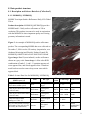
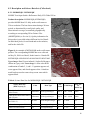
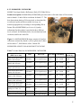
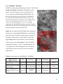
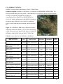
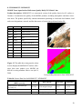
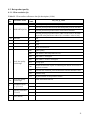
MOD09 (Surface Reflectance) User’s Guide
MODIS Land Surface Reflectance Science Computing Facility
Principal Investigator: Dr. Eric F. Vermote
Web site: http://modis-sr.ltdri.org
Correspondence e-mail address: [email protected]
Prepared by E. F. Vermote and S. Y. Kotchenova
Version 1.1
March, 2008
Table of Contents
1. Product description ............................................................................................................................... 4
2. List of products ..................................................................................................................................... 4
3. Differences between Collection 4 and Collection 5 ............................................................................. 5
4. Data ordering (& browsing).................................................................................................................. 5
5. Data viewing tools ................................................................................................................................ 6
6. Data product granule ID ....................................................................................................................... 6
7. Data product grids................................................................................................................................. 7
7.1. MODIS sinusoidal grid.................................................................................................................. 7
7.2. Climate Modeling Grid (CMG) ..................................................................................................... 8
8. Data product structure........................................................................................................................... 9
8.1. Description and Science Data Sets (Collection 5)......................................................................... 9
8.1.1. MOD09GQ / MYD09GQ ....................................................................................................... 9
8.1.2. MOD09GA / MYD09GA ..................................................................................................... 10
8.1.3. MOD09Q1 / MYD09Q1....................................................................................................... 12
8.1.4. MOD09A1 / MYD09A1....................................................................................................... 13
8.1.5. MOD09CMG / MYD09CMG .............................................................................................. 14
8.2. Description and Science Data Sets (Collection 4)....................................................................... 16
8.2.1. MOD09GQK / MYD09GQK ............................................................................................... 16
8.2.2. MOD09GHK / MYD09GHK ............................................................................................... 17
8.2.3. MOD09Q1 / MYD09Q1....................................................................................................... 18
8.2.4. MOD09A1 / MYD09A1....................................................................................................... 19
8.2.5 MOD09GST / MYD09GST .................................................................................................. 20
8.3. Data product quality .................................................................................................................... 21
8.3.1. 250-m resolution QA ............................................................................................................ 21
8.3.2. 500-m and coarse resolution QA .......................................................................................... 22
8.4. Data product state flags ............................................................................................................... 23
8.4.1. 500-m and 1-km resolution data state QA (Collection 5)..................................................... 23
8.4.2. 1-km resolution data state QA (Collection 4)....................................................................... 24
8.5. Geolocation flags (Collection 5).................................................................................................. 25
8.6. Scan value information (Collection 5)......................................................................................... 26
8.7. Internal climatology (Collection 5) ............................................................................................. 27
8.8. Orbit and coverage (Collection 4) ............................................................................................... 28
9. Useful links......................................................................................................................................... 29
2
If there is something else you would like to see in the MOD09 User's Guide, please write to us at
[email protected]. We will be happy to consider your suggestions!
Notes:
a) A number of significant improvements have also been introduced into the AC algorithm, including
the LUT-format modification for a more accurate interpolation of atmospheric parameters and the use
of dynamic aerosol models and ocean bands for improved aerosol retrieval over land surface. A detailed description of these changes can be found at the MODIS Land Quality Assessment Web site
(http://landweb.nascom.nasa.gov/cgi-bin/QA_WWW/newPage.cgi).
b) Please check the product availability on our Web site at http://modis-sr.ltdri.org.
3
1. Product description
MOD09 (MODIS Surface Reflectance) is a seven-band product computed from the MODIS Level
1B land bands 1 (620-670 nm), 2 (841-876 nm), 3 (459-479), 4 (545-565 nm), 5 (1230-1250 nm), 6
(1628-1652 nm), and 7 (2105-2155 nm). The product is an estimate of the surface spectral reflectance
for each band as it would have been measured at ground level as if there were no atmospheric scattering or absorption. It corrects for the effects of atmospheric gases, aerosols, and thin cirrus clouds.
2. List of products
Collection 4
Product Full Name
Product Abbreviation
Terra
Aqua
Surface Reflectance Daily L2G Global 250 m
MOD09GQK
MYD09GQK
Surface Reflectance Daily L2G Global 500 m
MOD09GHK
MYD09GHK
Surface Reflectance 8-Day L3 Global 250 m
MOD09Q1
MYD09Q1
Surface Reflectance 8-Day L3 Global 500 m
MOD09A1
MYD09A1
Surface Reflectance Quality Daily L2G Global 1km
MOD09GST
MYD09GST
Collection 5
Product Full Name
Product Abbreviation
Terra
Aqua
Surface Reflectance Daily L2G Global 250 m
MOD09GQ
MYD09GQ
Surface Reflectance Daily L2G Global 500 m and 1 km
MOD09GA
MYD09GA
Surface Reflectance 8-Day L3 Global 250 m
MOD09Q1
MYD09Q1
Surface Reflectance 8-Day L3 Global 500 m
MOD09A1
MYD09A1
Surface Reflectance Daily L3 Global 0.05Deg CMG*
MOD09CMG
MYD09CMG
*CMG – Climate Modeling Grid
4
3. Differences between Collection 4 and Collection 5
The contents of MOD09 have been changed to meet the user's demand.
a) The Daily Surface Reflectance Quality product at 1-km resolution was incorporated into the Daily
Surface Reflectance product at 500-m resolution.
b) The Daily Surface Reflectance products at 500-m and 1-km resolution have new abbreviated names.
c) A new product called Global Daily Surface Reflectance at 0.05° resolution was created. This product is applied on a Climate Modeling Grid (CMG) for the purpose of being used in climate simulation
models.
4. Data ordering (& browsing)
a) EOS (Earth Observing System) Data Gateway
The main source of data, a “place an order” database, a quick-start tutorial.
Link: http://edcimswww.cr.usgs.gov/pub/imswelcome/
b) LP DAAC (Land Processes Distributed Active Archive Center)
Useful information and links, ftp-access to a subset of MODIS land products.
Link: http://edcdaac.usgs.gov/main.asp
c) US Geological Survey (USGS) Global Visualization (GloVIS)
Access to selected MODIS land products with browse capability.
Link: http://glovis.usgs.gov/
d) MODIS Land Global Browse Images
5-km versions of selected product to enable synoptic quality assessment.
Link: http://landweb.nascom.nasa.gov/cgi-bin/browse/browse.cgi
e) Earth Science Data Interface (ESDI) at the Global Land Cover Facility
32-day composites, images in GeoTiff format, limited products.
Link: http://landcover.org/index.shtml
5
5. Data viewing tools
a) Imager (platform: Linux)
A software tool specifically designed by the MODIS LSR SCF for viewing surface reflectance suites.
Link: http://modis-sr.ltdri.org/MAIN_MODIS_SOFTWARE/IMAGER.html
b) HDFLook (platforms: SUN, AIX, SGI, Linux, MacOSX, Cygwin)
A multifunctional data processing and visualization tool for land, ocean and atmosphere MODIS data.
Link: http://www-loa.univ-lille1.fr/Hdflook/hdflook_gb.html
c) ENVI (platforms: Windows & Linux)
A software for the visualization, analysis, and presentation of all types of digital imagery.
Link: http://www.ittvis.com/envi/
d) HDF Explorer (platform: Windows)
A software environment where data are first viewed in a tree-like interface, and then optionally loaded
and visualized in a variety of ways.
Link: http://www.space-research.org/
6. Data product granule ID
Example 1: MOD09GHK.A2006351.h18v06.004.2006353163945.hdf
MOD09GHK: product name (MODIS Terra Surface Reflectance Daily L2G Global 500 m)
A2000351: Acquisition year (2006) and Julian day (351)
h18v06: tile ID (see MODIS sinusoidal grid)
004: Collection 4
2006353163945: Production year (2006), Julian day (353), and time (16:39:45)
Example 2: MOD09CMG.A2000338.005.2006332091104.hdf
MOD09CMG: product name (MODIS Terra Surface Reflectance Daily L3 Global 0.05Deg. CMG)
A2000338: Acquisition year (2000) and Julian day (338)
005: Collection 5
2006332091104: Production year (2006), Julian day (332), and time (09:11:04)
6
7. Data product grids
7.1. MODIS sinusoidal grid
The Earth's surface is divided into tiles (10° x 10°).
Figure 1. The MODIS sinusoidal grid with an example tile shown as a RGB-image produced from the
MODIS data acquired on December 3, 2006 over the US East cost. This product Granule ID is
MOD09A1.A2000337.h11v05.005.2006342055602.hdf.
7
7.2. Climate Modeling Grid (CMG)
The resolution of CMG is 0.05°. This grid is primarily used in climate studies.
Figure 2. An example of MODIS product based on the Climate Modeling Grid. The shown RGB-color
image was produced from the MODIS data acquired on December 4, 2000. The product granule ID is
MOD09CMG.A2000338.005.2006332091104.hdf.
8
8. Data product structure
8.1. Description and Science Data Sets (Collection 5)
8.1.1. MOD09GQ / MYD09GQ
MODIS Terra/Aqua Surface Reflectance Daily L2G Global
250 m
Product description: MOD09GQ (MYD09GQ) provides
MODIS band 1-2 daily surface reflectance at 250-m
resolution. This product is meant to be used in conjunction
with the MOD09GA where important quality and viewing
geometry information is stored.
Figure 3. An example of MOD09GQ surface reflectance
product. The corresponding MODIS data were collected on
December 3, 2000 over the US territory (in particular, over
Alabama, Mississippi and Florida). Product Granule ID:
MOD09GQ.A2000339.h10v05.005.2006339053418.hdf.
Upper image: Band 2 (near-infrared ) surface reflectance
shown on a gray scale. Lower image: A false-color RGB
combination of bands 2, 1, and 1. Vegetation appears red,
water appears blue, and clouds appears white. A land/sea
mask has been used to remove deep ocean water which
appears black.
Table 1. Science Data Sets for MOD09GQ / MYD09GQ.
Science Data Sets
(HDF Layers) (5)
num_observations: number of
observations within a pixel
Units
Bit Type
Fill
Value
Valid Range
Scale Factor
8-bit signed
integer
-1
0 - 127
NA
250m Surface Reflectance Band
Reflectance
1 (620-670 nm)
16-bit signed
integer
-28672
-100 - 16000
0.0001
250m Surface Reflectance Band
Reflectance
2 (841-876 nm)
16-bit signed
integer
-28672
-100 - 16000
0.0001
250m Reflectance Band
Quality (see Table 11)
16-bit unsigned
integer
2995
0 - 4096
NA
0 - 100
(0.001)
0.0099999997
76482582
None
Bit Field
obs_cov: Observation Coverage
(percentage of the grid cell area Percent
covered by the observation)
8-bit signed
integer
-1
9
8.1.2. MOD09GA / MYD09GA
MODIS Terra/Aqua Surface Reflectance Daily L2G Global 500 m and 1 km
Product description: MOD09GA (MYD09GA) provides
MODIS band 1-7 daily surface reflectance at 500-m
resolution and 1-km observation and geolocation statistics.
Figure 4. A MOD09GA RGB-image composed of surface
reflectance measured by MODIS bands 1 (red), 4 (green)
and 3 (blue) on December 6, 2000 over the US East coast.
Product granule ID:
MOD09GA.A2000340.h11v05.005.2006339102700.hdf
Table 2. Science Data Sets for MOD09GA / MYD09GA.
Data
Group
1 km
Science Data Sets
(HDF Layers (21))
Bit Type
num_observations_1km:
Number of Observations
NA
8-bit signed
integer
State_1km: Reflectance
Data State (see Table 13 )
Bit Field
Sensor Zenith Angle
Fill Value
Scale Factor
NA
16-bit unsigned
65535
integer
0 - 57335
NA
Degree
16-bit signed
integer
-32767
0 - 18000
0.01
Sensor Azimuth Angle
Degree
16-bit signed
integer
-32767
-18000 - 18000 0.01
Range: pixel to sensor
Meter
16-bit unsigned
65535
integer
27000 - 65535
25
Solar Zenith Angle
Degree
16-bit signed
integer
-32767
0 - 18000
0.01
Solar Azimuth Angle
Degree
16-bit signed
integer
-32767
-18000 - 18000 0.01
Bit Field
8-bit unsigned
integer
255
0 - 248
NA
none
8-bit signed in-1
teger
0 - 15
NA
(see Table 15 )
orbit_pnt: Orbit Pointer
********************
********
**********
-1
Valid Range
0 - 127
gflags: Geolocation flags
*****
Units
********
**********
*********
10
500 m
8-bit signed
integer
-1
0 - 127
NA
sur_refl_b01: 500m Surface
Reflectance Band 1 (620Reflectance
670 nm)
16-bit signed
integer
-28672
-100 - 16000
0.0001
sur_refl_b02: 500m Surface
Reflectance Band 2 (841Reflectance
876 nm)
16-bit signed
integer
-28672
-100 - 16000
0.0001
sur_refl_b03: 500m Surface
Reflectance Band 3 (459Reflectance
479 nm)
16-bit signed
integer
-28672
-100 - 16000
0.0001
sur_refl_b04: 500m Surface
Reflectance Band 4 (545Reflectance
565 nm)
16-bit signed
integer
-28672
-100 - 16000
0.0001
sur_refl_b05: 500m Surface
Reflectance Band 5 (1230- Reflectance
1250 nm)
16-bit signed
integer
-28672
-100 - 16000
0.0001
sur_refl_b06: 500m Surface
Reflectance Band 6 (1628- Reflectance
1652 nm)
16-bit signed
integer
-28672
-100 - 16000
0.0001
sur_refl_b07: 500m Surface
Reflectance Band 7 (2105- Reflectance
2155 nm)
16-bit signed
integer
-28672
-100 - 16000
0.0001
QC_500m: 500m Reflectance Band Quality (see
Table 12)
Bit Field
32-bit unsigned
0787410671
integer
4294966019
NA
Obs_cov_500m: Observation coverage
Percent
8-bit signed
integer
-1
0 - 100
(0.01)
0.00999999
77648258
iobs_res: Observation numnone
ber
8-bit unsigned
integer
255
0 - 254
NA
q_scan: 250m scan value
information (see Table 16)
8-bit unsigned
integer
255
0 - 255
NA
num_observations_500m
none
Bit Field
11
8.1.3. MOD09Q1 / MYD09Q1
MODIS Terra/Aqua Surface Reflectance 8-Day L3 Global 250 m
Product description: MOD09Q1 (MYD09Q1) provides
MODIS band 1-2 surface reflectance at 250-m resolution. It
is a level-3 composite of MOD09GQ (MYD09GQ). Each
MOD09Q1 (MYD09Q1) pixel contains the best possible
L2G observation during an 8-day period as selected on the
basis of high observation coverage, low view angle, the
absence of clouds or cloud shadow, and aerosol loading.
Figure 5. An example of MOD09Q1 surface reflectance
product. The corresponding MODIS data were collected in
December, 2000 over the US territory (in particular, over
Alabama, Mississippi and Florida). Product Granule ID:
MOD09Q1.A2000337.h10v05.005.2006342044337.hdf.
Upper image: Band 2 (near-infrared ) surface reflectance
shown on a gray scale. Lower image: A false-color RGB
combination of bands 2, 1, and 1. Vegetation appears red,
water appears blue, and clouds appears white. A land/sea
mask has been used to remove deep ocean water which
appears black.
Table 3. Science Data Sets for MOD09Q1 / MYD09Q1
Science Data Sets
(HDF Layers (3))
Units
Bit Type
Fill Value
Valid Range
Scale Factor
250m Surface Reflectance
Reflectance
Band 1 (620-670 nm)
16-bit signed integer
-28672
-100 - 16000
0.0001
250m Surface Reflectance
Reflectance
Band 2 (841-876 nm)
16-bit signed integer
-28672
-100 - 16000
0.0001
250m Reflectance Band
Quality (see Table 11)
16-bit unsigned
integer
65535
0 - 32767
NA
Bit Field
12
8.1.4. MOD09A1 / MYD09A1
MODIS Terra/Aqua Surface Reflectance 8-Day L3 Global 500 m
Product description: MOD09A1 (MYD09A1) provides MODIS band 1-7 surface reflectance at 500
m resolution. It is a level-3 composite of 500-m resolution
MOD09GA (MYD09GA). Each product pixel contains the
best possible L2G observation during an 8-day period as
selected on the basis of high observation coverage, low view
angle, absence of clouds or cloud shadow, and aerosol loading.
Figure 6. A MOD09A1 RGB image composed of surface
reflectance data measured by bands 1 (red), 4 (green) and
3(blue) in December, 2000 over the US East coast. Granule
ID: MOD09A1.A2000337.h11v05.005.2006342055602.hdf
Table 4. Science Data Sets for MOD09A1 / MYD09A1
Science Data Sets
(HDF Layers (13))
Units
Bit Type
Fill Value
Valid Range
Scale
Factor
500m Surface Reflectance
Band 1 (620-670 nm)
Reflectance
16-bit signed integer
-28672
-100 - 16000
0.0001
500m Surface Reflectance
Band 2 (841-876 nm)
Reflectance
16-bit signed integer
-28672
-100 - 16000
0.0001
500m Surface Reflectance
Band 3 (459-479 nm)
Reflectance
16-bit signed integer
-28672
-100 - 16000
0.0001
500m Surface Reflectance
Band 4 (545-565 nm)
Reflectance
16-bit signed integer
-28672
-100 - 16000
0.0001
500m Surface Reflectance
Band 5 (1230-1250 nm)
Reflectance
16-bit signed integer
-28672
-100 - 16000
0.0001
500m Surface Reflectance
Band 6 (1628-1652 nm)
Reflectance
16-bit signed integer
-28672
-100 - 16000
0.0001
500m Surface Reflectance
Band 7 (2105-2155 nm)
Reflectance
16-bit signed integer
-28672
-100 - 16000
0.0001
500m Reflectance Band
Quality (see Table 12)
Bit Field
32-bit unsigned integer 4294967295
0 - 4294966531
NA
Solar Zenith Angle
Degree
16-bit signed integer
0
0 - 18000
0.01
View Zenith Angle
Degree
16-bit signed integer
0
0 - 18000
0.01
Relative Azimuth Angle
Degree
16-bit signed integer
0
-18000 - 18000
0.01
500m State Flags (see Table 13)
Bit field
16-bit unsigned integer 65535
0 - 57343
NA
Day of Year
Julian day
16-bit unsigned integer 65535
1 - 366
NA
13
8.1.5. MOD09CMG / MYD09CMG
MODIS Terra/Aqua Surface Reflectance Daily L3 Global 0.05Deg CMG
Product description: MOD09CMG (MYD09CMG) provides MODIS band 1-7 surface reflectance at
0.05-degree resolution. This product is based on a Climate Modeling Grid (CMG) for the purpose of
being used in climate simulation models.
Figure 7. A MOD09CMG RGB-image composed of surface reflectance data measured by bands 1
(red), 4 (green) and 3 (blue) on December 7, 2000. The MODIS product granule ID is
MOD09CMG.A2000341.005.2006347161131.hdf.
14
Table 5. Science Data Sets for MOD09CMG / MYD09CMG.
Science Data Sets
(HDF Layers (19))
Units
Fill
Value
Bit Type
Valid Range
Scale
Factor
Coarse Resolution Surface Reflectance
Band 1 (620-670 nm)
Reflectance
16-bit signed
integer
-28672
-100 - 16000
0.0001
Coarse Resolution Surface Reflectance
Band 2 (841-876 nm)
Reflectance
16-bit signed
integer
-28672
-100 - 16000
0.0001
Coarse Resolution Surface Reflectance
Band 3 (459-479 nm)
Reflectance
16-bit signed
integer
-28672
-100 - 16000
0.0001
Coarse Resolution Surface Reflectance
Band 4 (545-565 nm)
Reflectance
16-bit signed
integer
-28672
-100 - 16000
0.0001
Coarse Resolution Surface Reflectance
Band 5 (1230-1250 nm)
Reflectance
16-bit signed
integer
-28672
-100 - 16000
0.0001
Coarse Resolution Surface Reflectance
Band 6 (1628-1652 nm)
Reflectance
16-bit signed
integer
-28672
-100 - 16000
0.0001
Coarse Resolution Surface Reflectance
Band 7 (2105-2155 nm)
Reflectance
16-bit signed
integer
-28672
-100 - 16000
0.0001
Coarse Resolution Solar Zenith Angle
Degree
16-bit signed
integer
0
0 - 18000
0.01
Coarse Resolution View Zenith Angle
Degree
16-bit signed
integer
0
0 - 18000
0.01
Coarse Resolution Relative Azimuth
Angle
Degree
16-bit signed
integer
0
-18000 - 18000
0.01
Coarse Resolution Ozone
cm atm
8-bit unsigned
0
integer
0 -255
400
Coarse Resolution Brightness Temperadegrees K
ture Band 20 (3.360-3.840 µm)
16-bit un0
signed integer
0 - 40000
100
Coarse Resolution Brightness Temperadegrees K
ture Band 21 (3.929-3.989 µm)
16-bit un0
signed integer
0 - 40000
100
Coarse Resolution Brightness Temperadegrees K
ture Band 31 (10.780-11.280 µm)
16-bit un0
signed integer
0 - 40000
100
Coarse Resolution Brightness Temperadegrees K
ture Band 32 (11.770-12.270 µm)
16-bit un0
signed integer
0 - 40000
100
Coarse Resolution Granule Time
HHMM
16-bit integer
0 - 2355
1
Coarse Resolution QA (see Table 12)
Bit Field
32-bit un0
signed integer
0 - 1073741824
NA
Coarse Resolution Internal CM (see
Table 17)
Bit Field
16-bit un0
signed integer
1 - 8191
NA
Averaged Number of Pixels
unitless
8-bit unsigned
0
integer
1 - 40
NA
0
15
8.2. Description and Science Data Sets (Collection 4)
8.2.1. MOD09GQK / MYD09GQK
MODIS Terra/Aqua Surface Reflectance Daily L2G Global 250 m
Product description: MOD09GQK (MYD09GQK)
provides MODIS band 1-2 daily surface reflectance at
250-m resolution. The best observations during a 24-hour
period, as determined by overall pixel quality and
observational coverage, are matched geographically
according to corresponding 250-m Pointer Files
(MODPTQKM (see Section 9)). Quality information for
this product is provided at three different levels of detail:
for individual pixels, for each band and each resolution,
and for the whole file.
Figure 8. An example of MYD09GQK surface reflectance
product. The corresponding MODIS data were collected
on May 26, 2004 over Brazil, South America. Granule ID:
MYD09GQK.A2004148.h12v09.004.2004151002653.hdf.
Upper image: Band 2 (near-infrared ) Surface Reflectance
shown on a gray scale. Lower image: A false-color RGB
combination of bands 2, 1, and 1. Vegetation appears red,
water appears blue, and clouds appears white. A land/sea
mask has been used to remove deep ocean water which
appears black.
Table 6. Science Data Sets for MOD09GQK / MYD09GQK
Science Data Sets
(HDF Layers) (5)
Units
Data Type
Fill
Value
Valid Range
Scale Factor
(divide by)
250m Surface Reflectance Band 1
Reflectance 16-bit signed integer
(620-670 nm)
-28672
-100 - 16000
10000
250m Surface Reflectance Band 2
Reflectance 16-bit signed integer
(841-876 nm)
-28672
-100 - 16000
10000
250m Reflectance Band Quality
(see Table 11)
16-bit unsigned integer
2995
0 - 4096
NA
Orbit and coverage (see Table 18) Bit field
8-bit unsigned integer
15
0 - 255
NA
Number of Observations
8-bit signed integer
-1
0 - 127
NA
Bit field
NA
16
8.2.2. MOD09GHK / MYD09GHK
MODIS Terra/Aqua Surface Reflectance Daily L2G Global 500 m
Product description: MOD09GHK (MYD09GHK) provides surface reflectance data at 250-m resolution for bands 1-2 and at 500-m resolution for bands 3-7. The
best observations during a 24-hour period, as determined by
overall pixel quality and observational coverage, are
matched geographically according to corresponding 500-m
Pointer Files (MODPTHKM (see Section 9). Quality
information for this product is provided at three different
levels of detail: for individual pixels, for each band and each
resolution, and for the whole file.
Figure 9. A MOD09GHK RGB-image composed of surface
reflectance measured by bands 1 (red), 4 (green) and 3 (blue)
on December 17, 2000 Sahara, Africa. Granule ID:
MOD09GHK.A2006351.h18v06.004.2006353163945.hdf
Table 7. Science Data Sets for MOD09GHK / MYD09GHK
Science Data Sets
(HDF Layers (10))
Units
Data Type
Fill Value
Valid Range
Scale Factor
(divide by)
250m Surface Reflectance
Band 1 (620-670 nm)
Reflectance
16-bit signed integer
-28672
-100 - 16000
10000
250m Surface Reflectance
Band 2 (841-876 nm)
Reflectance
16-bit signed integer
-28672
-100 - 16000
10000
500m Surface Reflectance
Band 3 (459-479 nm)
Reflectance
16-bit signed integer
-28672
-100 - 16000
10000
500m Surface Reflectance
Band 4 (545-565 nm)
Reflectance
16-bit signed integer
-28672
-100 - 16000
10000
500m Surface Reflectance
Band 5 (1230-1250 nm)
Reflectance
16-bit signed integer
-28672
-100 - 16000
10000
500m Surface Reflectance
Band 6 (1628-1652 nm)
Reflectance
16-bit signed integer
-28672
-100 - 16000
10000
500m Surface Reflectance
Band 7 (2105-2155 nm)
Reflectance
16-bit signed integer
-28672
-100 - 16000
10000
500m Reflectance Band
Quality (see Table 12)
Bit field
32-bit unsigned inte787410671 0 - 4294967296 NA
ger
Orbit and coverage
Bit field
8-bit unsigned integer 15
0 - 255
NA
Number of Observations
NA
8-bit signed integer
0 - 127
NA
-1
17
8.2.3. MOD09Q1 / MYD09Q1
MODIS Terra/Aqua Surface Reflectance 8-Day L3 Global 250 m
Product description: MOD09Q1 (MYD09Q1) provides
band 1-2 surface reflectance at 250 m resolution. It is a
level-3 composite of MOD09GQK (MYD09GQK). The
best observations during an 8-day period, as determined
by overall pixel quality and observational coverage, are
matched geographically according to corresponding 250-m
Pointer Files (MODPTQKM (see Section 9)). Quality
information for the MOD09Q1 product is provided at three
different levels of detail: for individual pixels, for each band
and each resolution, and for the whole file.
Figure 10. An example of MYD09GQK surface reflectance
product. The corresponding MODIS data were collected in
May 2004 mostly over Brazil, South America. Granule ID:
MYD09Q1.A2004145.h12v10.004.2004157154243.hdf.
Upper image: Band 2 (near-infrared ) surface reflectance
shown on a gray scale. Lower image: A false-color RGB
combination of bands 2, 1, and 1. Vegetation appears red,
water appears blue, and clouds appears white. A land/sea
mask has been used to remove deep ocean water which
appears black.
Table 8. Science Data Sets for MOD09Q1 / MYD09Q1
Science Data Sets
(HDF Layers (3))
Units
Fill Value
Valid Range
Scale Factor
Surface Reflectance for band
Reflectance 16-bit signed integer
1 (620-670 nm)
-28672
-100 - 16000
0.0001
Surface Reflectance for band
Reflectance 16-bit signed integer
2 (841-876 nm)
-28672
-100 - 16000
0.0001
Surface reflectance 250m
quality control flags (see Table 11)
65535
0-4294966531
NA
Bit field
Data Type
16-bit unsigned
integer
18
8.2.4. MOD09A1 / MYD09A1
MODIS Terra/Aqua Surface Reflectance 8-Day L3 Global 500 m
Product description: MOD09A1 (MYD09A1) is a composite of MOD09GHK (MYD09GHK). The
best observations during an 8-day period, as determined by the overall pixel quality and observational
coverage, are matched geographically according to
corresponding 500-m Pointer Files (MODPTHKM (see
Section 9)). Quality information for the MOD09A1 product is
provided at three different levels of detail: for individual
pixels, for each band and each resolution, and for the whole
file.
Figure 11. A MOD09A1 RGB-image composed of surface
reflectance measured by bands 1 (red), 4 (green) and 3(blue)
in May 2004 mostly over Brazil, South America. Granule ID:
MYD09A1.A2004145.h12v10.004.2004157154243.hdf.
Table 9. Science Data Sets for MOD09A1 / MYD09A1
Science Data Sets
(HDF Layers (13))
Data Type-bit
Fill Value
Valid Range
Scale
Factor
Surface Reflectance for band 1
reflectance
(620-670 nm)
16-bit signed integer
-28672
-100 - 16000
0.0001
Surface Reflectance for band 2
reflectance
(841-876 nm)
16-bit signed integer
-28672
-100 - 16000
0.0001
Surface Reflectance for band 3
reflectance
(459-479 nm)
16-bit signed integer
-28672
-100 - 16000
0.0001
Surface Reflectance for band 4
reflectance
(545-565 nm)
16-bit signed integer
-28672
-100 - 16000
0.0001
Surface Reflectance for band 5
reflectance
(1230-1250 nm)
16-bit signed integer
-28672
-100 - 16000
0.0001
Surface Reflectance for band 6
reflectance
(1628-1652 nm)
16-bit signed integer
-28672
-100 - 16000
0.0001
Surface Reflectance for band 7
reflectance
(2105-2155 nm)
16-bit signed integer
-28672
-100 - 16000
0.0001
Units
Surface reflectance 500m quality control flags (see Table 12)
Bit field
32-bit unsigned integer
Solar zenith
Degree
16-bit signed integer
0
0 - 18000
0.01
View zenith
Degree
16-bit signed integer
0
0 - 18000
0.01
Relative azimuth
Degree
16-bit signed integer
0
-18000 - 18000
0.01
Surface reflectance 500m state
flags (see Table 13)
Bit field
16-bit unsigned integer
65535
0
NA
Surface reflectance day of year Julian Day 16-bit unsigned integer
65535
0 - 366
NA
4294967295 0 - 4294966531
NA
19
8.2.5 MOD09GST / MYD09GST
MODIS Terra/Aqua Surface Reflectance Quality Daily L2G Global 1 km
Product description: MOD09GST is a restructured version of the quality data in level-2 surface reflectance. It summarizes the quality of the MOD09 products, including atmospheric and other correction states. The product specifically contains information pertaining to cloud and cloud shadow, land
and water designations, aerosols, and the data source of corrections performed on the file.
color
cloud value
land/sea value
magenta [undefined] [undefined]
violet
clear
shallow ocean
yellow
cloudy
shallow ocean
green
clear
land
red
cloudy
land
white
clear
coastlines/shorelines
coral
cloudy
coastlines/shorelines
plum
cloudy
shallow inland water
cyan
cloudy
ephemeral water
blue
clear
continental/moderate ocean
sienna
cloudy
continental/moderate ocean
MOD09GHK RGB-image
Figure 12. The table above interprets the colors
used to display the MOD09GST surface reflectance data state product over MODIS tile
h08v06 covering northern Mexico on April 4,
2000.
Corresponding information from MOD09GST
Table 10. Science Data Sets for MOD09GST / MYD09GST
Science Data Sets
(HDF Layers (3))
Units
Data Type-bit
Fill Value
Valid Range
1km Reflectance Data State QA
(see Table 14 )
Bit field
16-bit unsigned integer
65535
0 - 65535
Orbit and coverage
Bit field
8-bit unsigned integer
15
0 - 255
Number of Observations
NA
8-bit signed integer
-1
0 - 127
20
8.3. Data product quality
8.3.1. 250-m resolution QA
Table 11. 250-m surface reflectance data QA description (16-bit).
Bit
No.
Bit
Comb.
Parameter Name
00
0-1
01
MODLAND QA bits 10
2-3═ cloud state
4-7
band 1 data quality
four bit range
Sur_refl_qc_250m
corrected product produced at ideal quality all bands
corrected product produced at less than ideal quality some or all bands
corrected product not produced due to cloud effects all bands
11
corrected product not produced due to other reasons some or all bands
may be fill value [Note that a value of (11) overrides a value of (01)].
00
clear
01
cloudy
10
mixed
11
not set; assumed clear
0000
highest quality
1000
dead detector; data interpolated in L1B
1001
solar zenith >= 86 degrees
1010
solar zenith >= 85 and < 86 degrees
1011
missing input
1100
internal constant used in place of climatological data for at least one atmospheric constant
1101
correction out of bounds, pixel constrained to extreme allowable value
1110
L1B data faulty
1111
not processed due to deep ocean or clouds
811═
band 2 data quality
four bit range
12
atmospheric correction performed
1
yes
0
no
13
adjacency correction
performed
1
yes
0
no
1415
spare (unused)
-
---
SAME AS BAND ABOVE
21
8.3.2. 500-m and coarse resolution QA
Table 12. 500-m and coarse resolution surface reflectance data QA description (32-bit).
Bit
No.
0-1
2-5
6-9
Parameter Name
MODLAND QA bits
band 1 data quality, four bit range
Bit
Comb.
QC_500m / Coarse Resolution QA
00
corrected product produced at ideal quality -- all bands
01
corrected product produced at less than ideal quality -some or all bands
10
corrected product not produced due to cloud effects -- all
bands
11
corrected product not produced for other reasons -- some
or all bands, may be fill value (11) [Note that a value of
(11) overrides a value of (01)].
0000
highest quality
1000
dead detector; data interpolated in L1B
1001
solar zenith >= 86 degrees
1010
solar zenith >= 85 and < 86 degrees
1011
missing input
1100
internal constant used in place of climatological data for at
least one atmospheric constant
1101
correction out of bounds, pixel constrained to extreme allowable value
1110
L1B data faulty
1111
not processed due to deep ocean or clouds
band 2 data quality four bit range
same as band above
10-13 band 3 data quality four bit range
same as band above
14-17 band 4 data quality four bit range
same as band above
18-21 band 5 data quality four bit range
same as band above
22-25 band 6 data quality four bit range
same as band above
26-29 band 7 data quality four bit range
same as band above
30
atmospheric correction performed
31
adjacency correction performed
1
yes
0
no
1
yes
0
no
22
8.4. Data product state flags
8.4.1. 500-m and 1-km resolution data state QA (Collection 5)
Table 13. 500-m and 1-km resolution data state QA description (16-bit)
Bit No.
0-1
2
3-5
6-7
8-9
Parameter Name
cloud state
cloud shadow
land/water flag
aerosol quantity
cirrus detected
10
internal cloud algorithm flag
11
internal fire algorithm flag
12
MOD35 snow/ice flag
13
Pixel is adjacent to cloud
Bit Comb.
state_1km
00
clear
01
cloudy
10
mixed
11
not set, assumed clear
1
yes
0
no
000
shallow ocean
001
land
010
ocean coastlines and lake shorelines
011
shallow inland water
100
ephemeral water
101
deep inland water
110
continental/moderate ocean
111
deep ocean
00
climatology
01
low
10
average
11
high
00
none
01
small
10
average
11
high
1
cloud
0
no cloud
1
fire
0
no fire
1
yes
0
no
1
yes
0
no
23
14
BRDF correction performed
15
internal snow mask
1
yes
0
no
1
snow
0
no snow
8.4.2. 1-km resolution data state QA (Collection 4)
Table 14. 1-km Surface Reflectance data state QA Description (16-bit) for Collection 4.
Bits 10-16 contain different information in Collection 4 product compared to Collection 5 product.
10
PGE11 cloud algorithm flag
11
PGE11 fire algorithm flag
12
MOD35 snow/ice flag
13-14
15
1
clear
0
cloudy
1
fire
0
no fire
1
yes
0
no
00
no
BRDF correction performed 01
PGE11 snow algorithm flag
Montana methodology
10
Boston methodology
1
snow
0
no snow
24
8.5. Geolocation flags (Collection 5)
Table 15. 1-kilometer geolocation flags (16-bit).
Bit No.
Description
0-2
fill
3
Sensor range validity flag
4
Digital elevation model quality flag
5
Terrain data validity
6
Ellipsoid intersection flag
7
Input data flag
Bit Comb.
state_1km
00
Fill
0
Valid
1
Invalid
0
Valid
1
Missing/inferior
0
Valid
1
Invalid
0
Valid intersection
1
No intersection
0
Valid
1
Invalid
25
8.6. Scan value information (Collection 5)
Table 16. 250-m scan value information description (8-bit).
Bit No.
Parameter Name
0
missing observation in quadrant 4 [+0.5 row, +0.5 column]
1
missing observation in quadrant 3 [+0.5 row, -0.5 column];
2
missing observation in quadrant 2 [-0.5 row, +0.5 column]
3
missing observation in quadrant 1 [-0.5 row, -0.5 column]
4
scan of observation in quadrant 4 [+0.5 row, +0.5 column]
5
scan of observation in quadrant 3 [+0.5 row, +0.5 column]
6
scan of observation in quadrant 2 [+0.5 row, +0.5 column]
7
scan of observation in quadrant 1 [+0.5 row, +0.5 column]
Bit Comb. q_scan
1
yes
0
no
1
yes
0
no
1
yes
0
no
1
yes
0
no
1
same
0
different
1
same
0
different
1
same
0
different
1
same
0
different
Note: The 250-m samples are for each of four quadrants within a 500-m cell. The first line/sample is in
the upper left (north-west) corner of the image.
• 0 -- first 250m line (row), first 250m sample (column)
• 1 -- first 250m line, second 250m sample
• 2 -- second 250m line, first 250m sample
• 3 -- second 250m line, second 250m sample
26
8.7. Internal climatology (Collection 5)
Table 17. Coarse resolution internal CM (15-bit).
Bit No.
Description
0
cloudy
1
clear
2
high clouds
3
low clouds
4
snow
5
fire
6
sun glint
7
dust
8
cloud shadow
9
pixel is adjacent to cloud
10-11
cirrus
12
pan flag
13
criteria used for aerosol retrieval
14
AOT (aerosol optical thinkness) has climatological values
15
Unused
Bit Comb.
state
1
yes
0
no
1
yes
0
no
1
yes
0
no
1
yes
0
no
1
yes
0
no
1
yes
0
no
1
yes
0
no
1
yes
0
no
1
yes
0
no
1
yes
0
no
00
none
01
small
10
average
11
high
1
salt pan
0
no salt pan
1
criterion 2
0
criterion 1
1
yes
0
no
-
-
27
8.8. Orbit and coverage (Collection 4)
Table 18. Orbit and coverage data set (8-bit) for Collection 4 (the orbit the observation came from and
the observation coverage).
Bit No. Parameter Name
0-3
orbit number
4
scan half flag
6-7
land/water flag
Bit Comb.
orb_cov_1
range: from 0 to 13
key: from 0000 (0) to 1011 (13)
0
top half
1
bottom half
000
0.0 – 12.5%
001
12.5 – 25.0%
010
25.0 – 37.5%
011
37.5 – 50.0%
100
50.0 – 62.5%
101
62.5 – 75.0%
110
75.0 – 87.5%
111
87.5 – 100.0%
Note: The orbit number is not the absolute orbit number but a relative orbit number in the file. In addition a flag is stored which distinguishes between observations which are in the top half of the scan (the
first 5 1-km scan lines in the along track direction) and the bottom half of the scan (the last 5 1-km
scan lines). The observation coverage is the area of intersection of observation footprint and cell divided by the area of the observation.
28
9. Useful links
a) 250-m Pointer Files (MODPTQKM)
Link: http://edcdaac.usgs.gov/modis/modptqkmv4.asp
b) 500-m Pointer Files (MODPTQKM)
Link: http://edcdaac.usgs.gov/modis/modptqkmv4.asp
29