1
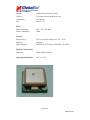
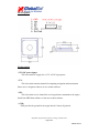
Available from www.dpcav.com
Digital Products Company
EM-406
GPS RECEIVER ENGINE BOARD
PRODUCT GUIDE
GlobalSat Technology Corporation
16, No.186,Chien 1 Road, 235Chung Ho City,Taipei Hsien, Taiwan ,R.O.C.
www.globalsat.com.tw
USGlobalSat, Inc. (USA Sales)
1308 John Reed Court, City of Industry, CA 91745
www.usglobalsat.com
Page 1 of 5
EM406-081705
Features:
SiRF starⅢ high performance GPS Chip Set
Very high sensitivity (Tracking Sensitivity: -159 dBm)
Extremely fast TTFF (Time To First Fix) at low signal level
Support NMEA 0183 data protocol
Built-in SuperCap to reserve system data for rapid satellite acquisition
Built-in patch antenna
LED indicator for GPS fix or not fix
LED OFF:
LED ON:
LED Flashing:
Receiver switch off
No fixed, Signal searching
Position Fixed
Specification:
General
Chipset
SiRF StarⅢ
Frequency
C/A code
Channels
L1, 1575.42 MHz
1.023 MHz chip rate
20 channel all-in-view tracking
Sensitivity
-159 dBm
Accuracy
Position
10 meters, 2D RMS
Velocity
Time
5 meters, 2D RMS, WAAS enabled
0.1 m/s
1us synchronized to GPS time
Datum
Default
WGS-84
Acquisition Time
Reacquisition
Hot start
Warm start
Cold start
0.1 sec., average
1 sec., average
38 sec., average
42 sec., average
Page 2 of 5
EM406-081705
Dynamic Conditions
Altitude
Velocity
Acceleration
Jerk
18,000 meters (60,000 feet) max
515 meters /second (1000 knots) max
Less than 4g
20m/sec **3
Power
Main power input
Power consumption
4.5V ~ 6.5V DC input
70mA
Protocol
Electrical level
Baud rate
TTL level, Output voltage level: 0V ~ 2.85V
4,800 bps
Output message
NMEA 0183 GGA, GSA, GSV, RMC, VTG, GLL
Physical Characteristics
Dimension
30mm*30mm*10.5mm
Operating temperature
-40℃ to +85℃
Page 3 of 5
EM406-081705
Pin Assignment
Pin description
* VIN (DC power input):
This is the main DC supply for a 4.5V ~6.5 DC input power.
* TX:
This is the main transmits channel for outputting navigation and measurement
data to user’s navigation software or user written software.
* RX:
This is the main receive channel for receiving software commands to the engine
board from SiRFdemo software or from user written software.
* GND:
GND provides the ground for the engine board. Connect all grounds.
All product specifications subject to change without notice.
Page 4 of 5
EM406-081705
SOFTWARE COMMAND
NMEA Output Command
GGA-Global Positioning System Fixed Data
Table B-2 contains the values for the following example:
$GPGGA,161229.487,3723.2475,N,12158.3416,W,1,07,1.0,9.0,M,,,,0000*18
Table B-2 GGA Data Format
Name
Example
Message ID
UTC Time
Latitude
N/S Indicator
Longitude
E/W Indicator
Position Fix Indicator
Satellites Used
HDOP
MSL Altitude1
Units
Geoid Separation1
Units
Age of Diff. Corr.
Diff. Ref. Station ID
Checksum
<CR><LF>
$GPGGA
161229.487
3723.2475
N
12158.3416
W
1
07
1.0
9.0
M
M
Units
Description
GGA protocol header
hhmmss.sss
ddmm.mmmm
N=north or S=south
dddmm.mmmm
E=east or W=west
See Table B-3
Range 0 to 12
Horizontal Dilution of Precision
meters
meters
meters
meters
second
Null fields when DGPS is not used
0000
*18
End of message termination
SiRF Technology Inc. does not support geoid corrections. Values are WGS84 ellipsoid heights.
Table B-3 Position Fix Indicator
Value
Description
0
Fix not available or invalid
1
GPS SPS Mode, fix valid
2
Differential GPS, SPS Mode , fix valid
3
GPS PPS Mode, fix valid
Page 5 of 5
EM406-081705
GLL-Geographic Position-Latitude/Longitude
Table B-4 contains the values for the following example:
$GPGLL,3723.2475,N,12158.3416,W,161229.487,A*2C
Table B-4 GLL Data Format
Name
Message ID
Latitude
N/S Indicator
Longitude
E/W Indicator
UTC Position
Status
Checksum
<CR><LF>
Example
$GPGLL
3723.2475
n
12158.3416
W
161229.487
A
*2C
Units
Description
GLL protocol header
ddmm.mmmm
N=north or S=south
dddmm.mmmm
E=east or W=west
hhmmss.sss
A=data valid or V=data not valid
End of message termination
GSA-GNSS DOP and Active Satellites
Table B-5 contains the values for the following example:
$GPGSA,A,3,07,02,26,27,09,04,15,,,,,,1.8,1.0,1.5*33
Table B-5 GSA Data Format
Name
Message ID
Mode1
Mode2
Satellite Used1
Satellite Used1
…..
Satellite Used1
PDOP
HDOP
VDOP
Checksum
<CR><LF>
Example
$GPGSA
A
3
07
02
Units
Description
GSA protocol header
See Table B-6
See Table B-7
Sv on Channel 1
Sv on Channel 2
Sv on Channel 12
Position dilution of Precision
Horizontal dilution of Precision
Vertical dilution of Precision
1.8
1.0
1.5
*33
1.
End of message termination
Satellite used in solution.
Table B-6 Mode1
Value
M
A
Description
Manual-forced to operate in 2D or 3D mode
2Dautomatic-allowed to automatically switch 2D/3D
Table B-7 Mode 2
Value
1
2
3
Description
Fix Not Available
2D
3D
Page 6 of 6
EM406-081705
GSV-GNSS Satellites in View
Table B-8 contains the values for the following example:
$GPGSV,2,1,07,07,79,048,42,02,51,062,43,26,36,256,42,27,27,138,42*71
$GPGSV,2,2,07,09,23,313,42,04,19,159,41,15,12,041,42*41
Table B-8 GSV Data Format
Name
Message ID
Number of Messages1
Message Number1
Satellites in View
Satellite ID
Elevation
Azimuth
SNR(C/No)
…….
Satellite ID
Elevation
Azimuth
SNR(C/No)
Checksum
<CR><LF>
Example
$GPGSV
2
1
07
07
79
048
42
27
27
138
42
*71
Description
GSV protocol header
Range 1 to 3
Range 1 to 3
degrees
degrees
dBHz
Degrees
Degrees
dBHz
Channel 1(Range 1 to 32)
Channel 1(Maximum90)
Channel 1(True, Range 0 to 359)
Range 0 to 99,null when not tracking
…….
Channel 4 (Range 1 to 32)
Channel 4(Maximum90)
Channel 4(True, Range 0 to 359)
Range 0 to 99,null when not tracking
End of message termination
Depending on the number of satellites tracked multiple messages of GSV data may be required.
RMC-Recommended Minimum Specific GNSS Data
Table B-10 contains the values for the following example:
$GPRMC,161229.487,A,3723.2475,N,12158.3416,W,0.13,309.62,120598,,*10
Table B-10 RMC Data Format
Name
Example
Units
Description
Message ID
$GPRMC
RMC protocol header
UTC Time
161229.487
hhmmss.sss
Status
A
A=data valid or V=data not valid
Latitude
3723.2475
ddmm.mmmm
N/S Indicator
N
N=north or S=south
Longitude
12158.3416
dddmm.mmmm
E/W Indicator
W
E=east or W=west
Speed Over Ground
0.13
knots
Course Over Ground
309.62
degrees
True
Date
120598
ddmmyy
Magnetic Variation2
degrees
E=east or W=west
Checksum
*10
<CR><LF>
End of message termination
SiRF Technology Inc. does not support magnetic declination. All “course over ground” data are
geodetic WGS48 directions.
Page 7 of 7
EM406-081705
VTG-Course Over Ground and Ground Speed
$GPVTG,309.62,T,,M,0.13,N,0.2,K*6E
Name
Message ID
Course
Reference
Course
Reference
Speed
Units
Speed
Units
Checksum
<CR><LF>
Example
$GPVTG
309.62
T
Units
degrees
degrees
M
0.13
N
0.2
K
*6E
knots
Km/hr
Description
VTG protocol header
Measured heading
True
Measured heading
Magnetic
Measured horizontal speed
Knots
Measured horizontal speed
Kilometers per hour
End of message termination
Page 8 of 8
EM406-081705