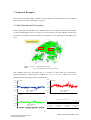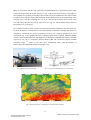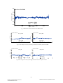
1
STR10/11
Qianxin Wang, Tianhe Xu, Guochang Xu
HALO_GPS Software User Manual
(High Altitude and LOng Range Airborne
GPS Positioning Software)
ISSN 1610-0956
Q. Wang et al., HALO_GPS Software User Manual
Version of 2010
Scientific Technical Report STR10/11
www.gfz-potsdam.de
Qianxin Wang, Tianhe Xu, Guochang Xu
HALO_GPS Software User Manual
(High Altitude and LOng Range Airborne
GPS Positioning Software)
Version of 2010
Impressum
Telegrafenberg
D-14473 Potsdam
Gedruckt in Potsdam
November 2010
ISSN 1610-0956
Die vorliegende Arbeit
in der Schriftenreihe
Scientific Technical Report (STR) des GFZ
ist in elektronischer Form erhältlich unter
www.gfz-potsdam.de - Neuestes - Neue
Publikationen des GFZ
Scientific Technical Report STR10/11
Qianxin Wang, Tianhe Xu, Guochang Xu
HALO_GPS Software User Manual
(High Altitude and LOng Range Airborne
GPS Positioning Software)
Version of 2010
Impressum
Telegrafenberg
D-14473 Potsdam
Gedruckt in Potsdam
November 2010
ISSN 1610-0956
Scientific Technical Report STR10/11
Die vorliegende Arbeit
in der Schriftenreihe
Scientific Technical Report (STR) des GFZ
ist in elektronischer Form erhältlich unter
www.gfz-potsdam.de - Neuestes - Neue
Publikationen des GFZ
Scientific Technical Report STR 10/11
10.2312/GFZ.b103-10119
Deutsches GeoForschungsZentrum GFZ
HALO_GPS
(High Altitude and LOng Range Airborne GPS Positioning Software)
Software User Manual
Version of 2010
Qianxin Wang, Tianhe Xu, Guochang Xu
GFZ German Research Centre for Geosciences
Department 1: Geodesy and Remote Sensing
Telegrafenberg, 14473 Potsdam, Germany
June 2010
1
Scientific Technical Report STR 10/11
10.2312/GFZ.b103-10119
Deutsches GeoForschungsZentrum GFZ
HALO_GPS Software User Manual
Contents
1. Introduction ................................................................................................................................... 3
2. Structure of Software .................................................................................................................... 4
2.1 Main Function ..................................................................................................................... 4
2.2 Important Subroutines ......................................................................................................... 4
2.3 Diagram of Software ......................................................................................................... 13
3. Control File ................................................................................................................................. 14
3.1 Definitions of Input Parameters ........................................................................................ 14
3.2 Control File Format ........................................................................................................... 15
3.3 An Example of Control File .............................................................................................. 15
4. File Format .................................................................................................................................. 19
4.1 Input File Format .............................................................................................................. 19
4.2 Output File Format ............................................................................................................ 19
5. Strategies and Principles ............................................................................................................. 20
5.1 Outlier and Cycle Slip Detection ...................................................................................... 20
5.2 Clock Error Estimation ..................................................................................................... 21
5.3 Tropospheric Delay Correction ......................................................................................... 21
5.4 Ambiguity Resolution ....................................................................................................... 22
5.5 Robust Estimation ............................................................................................................. 23
5.6 Adjustment Method ........................................................................................................... 24
5.7 Automatic Choosing and Changing Reference Satellite ................................................... 24
5.8 Automatic Choosing and Changing Reference Station ..................................................... 24
6. Run of HALO_GPS .................................................................................................................... 28
7. Numerical Examples ................................................................................................................... 29
7.1 Static Data Kinematic Processing ..................................................................................... 29
7.2 Antenna Movement Experiment ....................................................................................... 30
7.3 Sea Buoy Experiment........................................................................................................ 32
7.4 NorthGrace2007 Campaign .............................................................................................. 32
7.5 AlpinAero2008 Campaign ................................................................................................ 33
8. Summary ..................................................................................................................................... 36
9. Acknowledgements ..................................................................................................................... 37
10. References ................................................................................................................................. 38
11. Appendixes ................................................................................................................................ 40
11.1 Appendixes 1: Definitions of Constants .......................................................................... 40
11.2 Appendixes 2: List of Figures ......................................................................................... 41
2
Scientific Technical Report STR 10/11
10.2312/GFZ.b103-10119
Deutsches GeoForschungsZentrum GFZ
1. Introduction
HALO_GPS is a precise GPS kinematic positioning software. It was developed at GFZ
Potsdam for the German HALO project. The goal is to develop a software which is able to achieve
cm-level accuracy for an aircraft trajectory for application in airborne gravimetry.
To fulfill the needs of the HALO project, some new algorithms and strategies are developed
and adopted in this software. It can automatically choose and change reference satellite, as well as
the reference station, automatically detect cycle slips, outliers, bad observation data, and potential
large jumps in the receiver clock. The one-click functionality is implemented for ease of use. All
process steps will be finished automatically after the user enters one command.
The development of the HALO_GPS software was started in 2009, first year for theoretical
study and then for code design. It has been tested with various kinds of real data. Many
comparisons have been made with several well known GPS software packages, such as Ashtech
Solution, Trimble Geomatics Office, and GAMIT. The results show a strong stability and
reliability of HALO_GPS. The software has been used to successfully process the GPS data of
NorthGrace2007 and AlpinAero2008 airborne gravimetry campaigns.
This manual outlines the characteristics of the software and describes how to use it. The
principles and new features are outlined systematically and referred partly to existing references.
The major functions of some important subroutines are introduced briefly. Numerical examples of
kinematic positioning and internal tests as well as external comparisons are given.
This software is developed in Fortran 90 under Unix operating system and can be used on
PCs under Linux without any change. The user interface to HALO_GPS is command driven with
default values for most processing. This interface provides flexibility and should make the
software usable with little training.
3
Scientific Technical Report STR 10/11
10.2312/GFZ.b103-10119
Deutsches GeoForschungsZentrum GFZ
2. Structure of Software
HALO_GPS software consists of a main function and about 50 important subroutines. Each
subroutine attends to its own duties, which are connected with the main function main.f90 via the
input and output parameters. Therefore, it is very important for using this software to known the
definitions of input parameters, output parameters and the function of each subroutine.
2.1 Main Function
The main function is the most important part in the most of software, which is used to organize the
rest of the subroutines. The main function of HALO_GPS includes 15 important steps, which are
outlined below.
1. Reading Control File
2. Reading Precise Ephemeris
3. Reading Observation File of Reference Station
4. Reading Observation File of Kinematic Station
5. Scanning and Modifying All Observation Data
6. Single Point Positioning
7. Computing Receiver Clock Errors
8. Searching Common Satellites
9. Cycle Slip Detection
10. Choosing Reference Satellite
11. Forming Double Observation Equations
12. Initializing Matrixes and Ambiguities
13. Parameters Estimation with Sequential Adjustment
14. Scanning the Residuals
15. Generating Result Files and Summary
2.2 Important Subroutines
read_control_file.f90
Input parameters:
The address of control file
Example: “./Example/control_file/model_control_file_1.txt”
Output parameters:
A logical variable which represents whether the address of control file is right or not
Introduction:
This subroutine is used to read the control file defined by the user in a flexible form.
Some important variables are assigned initial values based on the definitions in the control file.
The definitions of control file will be described in Chapter 3.
4
Scientific Technical Report STR 10/11
10.2312/GFZ.b103-10119
Deutsches GeoForschungsZentrum GFZ
read_sp3.f90
Input parameters:
The address of precise ephemeris
Output parameters:
The number of healthy satellites and their ID;
The number of lost satellites and their ID;
The number of bad satellites and their ID;
The bad satellite means the satellite clock error valued is 999999.999999;
All information is saved in the structure variable named as igs.
igs(epoch)%Rtime
igs(epoch)%RMJD
igs(epoch)%Rx(satellite_id)
igs(epoch)%Ry(satellite_id)
igs(epoch)%Rz(satellite_id)
igs(epoch)%Rclock(satellite_id)
igs(epoch)%Rlogical(satellite_id)
------seconds at this epoch
------Modified Julian Day at this epoch
------X coordinate of this satellite at this epoch
------Y coordinate of this satellite at this epoch
------Z coordinate of this satellite at this epoch
------clock errors of this satellite at this epoch
------health of this satellite
ymdhms_to_MJD.f90
Input parameters:
Year, Month, Day, Hour, Minute, Second
Output parameters:
Modified Julian Date (MJD)
Introduction:
The routine converts a calendar date with hour, minute and second to a Modified Julian date.
The calendar date is ordered as year, month, day, hour, minute and second.
These values are stored in a single I*2 array.
This routine is only valid for date after 1600 Jan 0.
The relationship between JD and MJD is: JD = MJD + 2400000.5d0
matinv.f90
Input parameters:
The original matrix
The rows of this matrix and the columns of this matrix
Output parameters:
Inverse matrix
svs_cm_to_phs.f90
Input parameters:
MJD; Satellite ID; Satellite position of the center of mass
Output parameters:
The phase center position of satellite
5
Scientific Technical Report STR 10/11
10.2312/GFZ.b103-10119
Deutsches GeoForschungsZentrum GFZ
sun20.f90
Input parameters:
XMJD (Epoch in modified Julian date in R*8 Barycentric Dynamical Time corresponding to
ephemeris time)
Output parameters:
X (K), K=1, 2, and 3: Rectangular coordinates of the sun in equatorial system J2000.0 (in AU)
R
: Distance of earth-sun (in AU)
L, B
: Ecliptical longitude, latitude in mean system of epoch XMJD
Introduction:
It is used to compute the position of the sun at XMJD time.
This subroutine was written using Simon Newcomb's "tables of the sun".
read_ref_obsfile.f90
Input parameters:
Address of observation file; reference station ID; start time; the number of epoch
Output parameters:
The height of antenna atthis station
The number of observation types
The specified types of observation
The sampling interval
GPS seconds at every epoch
MJD at every epoch
The number of satellites at every epoch
All satellites ID at every epoch
The number of read epoch
L1
L2
C1
P1
P2
C2
D1
D2
S1
S2
LI
MW
LC
---ref_i_Hant/ ref_i_Eant/ ref_i_Nant
---ref_i_obstype_num
---ref_i_obstype(10)
---ref_i_interval
---ref_i_G_time(epoch,1)
---ref_i_G_time_MJD(epoch,1)
---ref_i_G_sat_num(epoch,1)
---ref_i_satnum(epoch,32)
---ref_i_read_epoch
---ref_i_vobs1(epoch,sat_id)
---ref_i_vobs2(epoch,sat_id)
---ref_i_vobs3(epoch,sat_id)
---ref_i_vobs4(epoch,sat_id)
---ref_i_vobs5(epoch,sat_id)
---ref_i_vobs21(epoch,sat_id)
---ref_i_vobs22(epoch,sat_id)
---ref_i_vobs23(epoch,sat_id)
---ref_i_vobs24(epoch,sat_id)
---ref_i_vobs25(epoch,sat_id)
---ref_i_vobs6(epoch,sat_id)
---ref_i_vobs7(epoch,sat_id)
---ref_i_vobs8(epoch,sat_id)
Additional function:
Remove the abnormal observations;
Remove the observations of those satellites which belong to question satellites;
Remove the observations of GLONASS satellites;
6
Scientific Technical Report STR 10/11
10.2312/GFZ.b103-10119
Deutsches GeoForschungsZentrum GFZ
read_kin_obsfile.f90
Input parameters:
Address of observation file; kinematic station ID; start time; the number of epochs
Output parameters:
It is similar to read the observation file of reference station.
earth_tide.f90
Input parameters:
Julian Day; XYZ coordinates of station
Output parameters:
Tidal correction to site position (m)
Introduction:
The subroutine is used to compute the solid earth tide, based on the formulations in DSR thesis
with extension to the number of coefficients.
receiver_antenna_correction.f90
Input parameters:
Longitude of station; Latitude of station; Height of antenna at this station (ref_i_Hant/ ref_i_Eant/
ref_i_Nant)
Output parameters:
The corrections of receiver antenna phase centre
---ref_i_ant_x/ ref_i_ant_y/ ref_i_ant_z
---kin_i_ant_x/ kin_i_ant_y/ kin_i_ant_z
unify_obs_time.f90
Input parameters:
Reference station ID; kinematic station ID
Output parameters:
The real number of processing epochs of reference station and kinematic station
Introduction:
Firstly, this subroutine tries to find out the lost epochs in reference station and kinematic station.
Then it removes these epochs from the observations of reference station which are lost in that of
kinematic station and removes these epochs from the observations of kinematic station which are
lost in that of reference station.
Finally, the epochs between reference and kinematic stations are arranged in a certain order.
mjd_to_ymdhms.f90
Input parameters:
Modified Julian Date (MJD)
Output parameters:
Year, Month, Day, Hour, Minute, Second
Note:
If a full Julian date is used, the resolution of the seconds will only be about 10 microseconds, and
a MJD should yield a resolution of about 0.1 microseconds in the seconds.
7
Scientific Technical Report STR 10/11
10.2312/GFZ.b103-10119
Deutsches GeoForschungsZentrum GFZ
spp_1.f90
Input parameters:
Kinematic station ID; position and clock error of satellite (the structure variable IGS)
Output parameters:
XYZ and BLH coordinates of kinematic station
---kin_i_X(epoch, 1)/ kin_i_Y(epoch, 1)/ kin_i_Z(epoch, 1)
---kin_i_B(epoch, 1)/ kin_i_L(epoch, 1)/ kin_i_H(epoch, 1)
The clock error of kinematic station
---kin_i_C(epoch,1)
Satellite elevation angle at each epoch
---kin_i_elev(epoch, sat_id)
The weight of observations
---kin_i_sat_p(epoch, sat_id)
Introduction:
This subroutine computes the initial positions of kinematic station and receiver clock errors using
Pseudorange C1 based on the single point positioning.
solu_sat_xyzc.f90
Input parameters:
The transmit time of signal; Satellite ID
Output parameters:
The position and clock error of satellite
Introduction:
The subroutine uses 8 orders Chebyshev polynomial to interpolate satellite coordinates.
solu_ro_xyz.f90
Input parameters:
Epoch number; satellite ID; station mark (1=reference station; 2=kinematic station)
Output parameters:
The distance between satellite and reference station or kinematic station:
ref_i_Rox(j, sat) ref_i_Roy(j, sat) ref_i_Roz(j, sat) ref_i_R0(j, sat)
kin_i_Rox(j, sat) kin_i_Roy(j, sat) kin_i_Roz(j, sat) kin_i_R0(j, sat)
Introduction:
This subroutine computes the distances between satellite and the station taking into account the
influence of earth rotation.
xyz_blh.f90
Input parameters:
XYZ Cartesian coordinates in WGS-84 system
Output parameters:
BLH Geodetic coordinates in WGS-84 system
8
Scientific Technical Report STR 10/11
10.2312/GFZ.b103-10119
Deutsches GeoForschungsZentrum GFZ
spp_2.f90
Input parameters:
Kinematic station ID; the structure variable IGS
Output parameters:
The tropospheric delay of kinematic station at every epoch
Introduction:
---kin_i_trop(epoch, sat_id)
kin_i_trop(j, sat_id) = kin_i_dry_ztd(j, 1) * kin_i_dry_mf(j, sat_id)
+ kin_i_wet_ztd(j, 1) * kin_i_wet_mf(j, sat_id)
met_seasonal.f90
Input parameters:
JD; Latitude; Height
Output parameters:
Temperature in Celsius; Pressure in mbar; Relative humidity; Bias in surface temperature
Introduction:
This subroutine computes the temperature, pressure and relative humidity based on the seasonal
argument.
dry_saas_zen.f90
Input parameters:
Temperature; Latitude; Height; Pressure
Output parameters:
Dry zenith delay of the station
Introduction:
Routine to compute dry zenith delay based on Saastamoinen model.
wet_saas_zen.f90
Input parameters:
Temperature; Latitude; Height; Relative humidity
Output parameters:
Wet zenith delay of the station
Introduction:
Routine to compute wet zenith delay based on Saastamoinen model.
wet_press.f90
Input parameters:
Temperature; Relative humidity
Output parameters:
The partial pressure of water vapor
dry_mtt_map.f90
Input parameters:
Temperature; Latitude; Height; Elevation angle (in deg) of satellite
Output parameters:
Dry mapping function
9
Scientific Technical Report STR 10/11
10.2312/GFZ.b103-10119
Deutsches GeoForschungsZentrum GFZ
Introduction:
Niell global mapping function is adopted.
wet_mtt_map.f90
Input parameters:
Temperature; Latitude; Height; Elevation angle (in deg) of satellite
Output parameters:
Wet mapping function
Introduction:
Niell global mapping function is adopted.
spp_3.f90
Input parameters:
Kinematic station ID; the structure variable IGS
Output parameters:
XYZ and BLH coordinates of kinematic station
---kin_i_X(epoch, 1)/ kin_i_Y(epoch, 1)/ kin_i_Z(epoch, 1)
---kin_i_B(epoch, 1)/ kin_i_L(epoch, 1)/ kin_i_H(epoch, 1)
The clock error of kinematic station
---kin_i_C(epoch,1)
Satellite elevation angle at each epoch
---kin_i_elev(epoch, sat_id)
The weight of observations
---kin_i_sat_p(epoch, sat_id)
Introduction:
This subroutine computes the initial positions of kinematic station and receiver clock error using
Pseudorange C1 and the weight matrix of spp_1 solution again.
Additionally, it deletes those satellites with the low elevation angle.
ref_clock_1.f90
Input parameters:
Reference station ID; the structure variable IGS
Output parameters:
The clock errors of reference station
---ref_i_C(epoch,1)
Satellite elevation angle at each epoch --- ref_i_elev(epoch, sat_id)
The weight of observations
--- ref_i_sat_p(epoch, sat_id)
Introduction:
This subroutine computes the clock error of reference station using Pseudorange C1 and known
site coordinate.
ref_clock_2.f90
Input parameters:
Reference station ID; the structure variable IGS
Output parameters:
10
Scientific Technical Report STR 10/11
10.2312/GFZ.b103-10119
Deutsches GeoForschungsZentrum GFZ
The tropospheric delay of reference station at every epoch
---ref_i_trop(epoch, sat_id)
ref_clock_3.f90
Input parameters:
Reference station ID; the structure variable IGS
Output parameters:
The clock errors of reference station
---ref_i_C(epoch,1)
Satellite elevation angle at each epoch
---ref_i_elev(epoch, sat_id)
The weight of observations
---ref_i_sat_p(epoch, sat_id)
Introduction:
This subroutine computes the clock error of reference station using Pseudorange C1, known site
coordinate and the weight matrix of ref_clock_1 solution again.
In the same time, it deletes those satellites with the low elevation angle.
search_common_sat.f90
Input parameters:
Reference station ID; Kinematic station ID
Output parameters:
The total number of common satellites
All common satellite IDs
The times of each satellite in view
The start epoch of the Kth time in view
The end epoch of the Kth time in view
The number of common satellites at each epoch
Common satellite IDs at each epoch
Logical variable of the satellite changing
The number of lost satellites
Lost satellite ID
The number of added satellites
Add satellite ID
The type of satellite changing
---ref_i_tot_common_sat_num(1,1)
---ref_i_tot_common_satnum(1,i)
---ref_i_start_epoch_num(sat_id,1)
---ref_i_start_epochnum(sat_id,k)
---ref_i_end_epochnum(sat_id,k)
---ref_i_common_sat_num(epoch,1)
---ref_i_common_satnum(epoch,1)
---ref_i_change_sat(epoch,1)
---ref_i_lost_sat_num(epoch,1)
---ref_i_lost_satnum(epoch,i)
---ref_i_add_sat_num(epoch,1)
---ref_i_add_satnum(epoch,i)
0---no change
1---lost satellite
2---add satellite
3---lost satellite and add satellite
Introduction:
This subroutine searches the common satellites between reference station and kinematic station.
And all information of satellite’s changing is saved.
det_cycle_slip.f90
Input parameters:
Reference station ID; Kinematic station ID
Output parameters:
The number of cycle slips of every satellite
---ref_i_slip_num(sat_id, k)
The epoch number of cycle slips of every satellite ---ref_i_slipnum(sat_id, k,kk)
The number of outliers of every satellite
---ref_i_outlier_num(sat_id, k)
11
Scientific Technical Report STR 10/11
10.2312/GFZ.b103-10119
Deutsches GeoForschungsZentrum GFZ
The epoch number of outliers of every satellite
---ref_i_outliernum(sat_id, k,kk)
Introduction:
The subroutine is used to detect the cycle slip and outlier of every satellite based on the median
method. And it removes those observations if the observation time is less than the minimum
observation time. At the same time, the information of satellite rising and downing is updated.
Additionally, the reference satellite is chosen automatically.
Note:
The reference satellite is always placed on the 1st order in HALO_GPS.
form_sd_dd.90
Input parameters:
Reference station ID; Kinematic station ID
Output parameters:
The single differenced LC observations
---ref_i_vobs8_sd(epoch,sat_id)
The double differenced LC observations
---ref_i_vobs8_dd(epoch,sat_id)
The initial double differenced ambiguity of LC observations ---ref_i_dd_amb_LC(sat_id,k)
Introduction:
The subroutine is used to compute the single and double differenced LC observations.
Additionally, the initial double differenced ambiguity of L1, L2, and LC observation is fast
obtained by a new method, which is introduced in Chapter 5.
a_x_l.f90
Input parameters:
Reference station ID
Output parameters:
A_row, A_rank
---the row and column of matrix_A
X_row, X_rank
---the row and column of matrix_X
L_row, L_rank
---the row and column of matrix_L
P_row, P_rank
---the row and column of matrix_P
ref_i_amb_num
---the number of ambiguity paramters
ref_i_xyz_num
---the number of position paramters
logical_amb(j,sat_id,k) ---the Kth ambiguity of ith satellite at jth epoch
Introduction:
This subroutine computes the row and column number of some important matrix, which will be
used in the adjustment.
sequential_adjustment.f90
Input parameters:
Reference station ID; the structure variable IGS
Output parameters:
The final coordinate of kinematic station
---kin_i_X(epoch,1)/kin_i_Y(epoch,1)/kin_i_Z(epoch,1)
---kin_i_B(epoch,1)/kin_i_L(epoch,1)/kin_i_H(epoch,1)
The precision information at every epoch
---kin_i_sigmaX(epoch,1)/kin_i_sigmaY(epoch,1)/kin_i_sigmaZ(epoch,1)
---kin_i_sigmaB(epoch,1)/kin_i_sigmaL(epoch,1)/kin_i_sigmaH(epoch,1)
12
Scientific Technical Report STR 10/11
10.2312/GFZ.b103-10119
Deutsches GeoForschungsZentrum GFZ
RMS at every epoch
---kin_i_RMS(epoch,1)
The final double differenced ambiguity of LC observation ---ref_i_dd_amb_LC(sat_id,k)
Introduction:
The final coordinate and ambiguities of kinematic station are calculated based on the robust
sequential adjustment.
2.3 Diagram of Software
The data processing steps of this software are described in Fig.1.
(1) Program start;
(2) Read input parameter file for controlling the run of the software (an example of the definition
of the input parameter file is presented in Chapter 3);
(3) Read all possible data files for the run of the software (e.g., satellite information file, station
information file, tropospheric delay correction file, receiver antenna phase centre correction
file, etc.);
(4) Compute all possible corrections (e.g., antenna phase centre correction, earth tide correction,
tropospheric delay correction, clock error offsets, etc.);
(5) Data preprocessing (e.g., searching the common satellite, detecting cycle slip and outlier,
removing bad observation and receiver clock jump, etc.);
(6) Construction of single and double differenced observations;
(7) Initialization of matrix and all unknown parameters;
(8) Parameters estimation using sequential adjustment;
(9) Robust estimation;
(10) Output the results and summary;
(11) End of Program.
Start
Read User Command File
Read Ref Station Obs Files
Read Kin Station Obs Files
Read Navigation Files
Obtain Ref Station Obs Infor
Obtain Kin Station Obs Infor
Read Other Files
Obtain Other Obs Infor
Data Fusion
Data Pre-processing
Form Double Difference Obs
Initial All Unknown Parameters and Matrix
Adjustment / Filter
Analysis of Residuals
Put Out Results
End
Fig.1 The data processing flowchart of HALO_GPS
13
Scientific Technical Report STR 10/11
10.2312/GFZ.b103-10119
Deutsches GeoForschungsZentrum GFZ
3. Control File
The essential work to run the program for GPS data processing is to write an input parameter file
defined in a flexible form. Definitions of the input parameters, and control file format as well as a
standard control file template are introduced in following subsections.
3.1 Definitions of Input Parameters
(1)
(2)
(3)
(4)_(11)
(12)
(13)
(14)_(21)
(22)
(23)
(24)_(31)
(32)
(33)
(34)
(35)_(50)
(51)
(52)
(53)
Address of precise ephemeris
---character(len=57):: address_sp3_file
Address of broadcast ephemeris
---character(len=57) :: address_brdc_file
Address of observation file at the 1st reference station
---character(len=57) :: address_ref_1_obsfile
Address of observation file at the 2nd ~ 9th reference stations
Address of observation file at the 1st kinematic station
---character(len=57) :: address_kin_1_obsfile
Name of the 1st reference station
---character(len=57) :: name_ref_1
Name of the 2nd ~ 9th reference stations
Name of the 1st kinematic station
---character(len=57) :: name_kin_1
XYZ coordinates of the 1st reference station
---real*8 X_ref_1,Y_ref_1,Z_ref_1
XYZ coordinates of the 2nd ~ 9th reference stations
XYZ coordinates of the 1st kinematic station
---real*8 X_kin_1,Y_kin_1,Z_kin_1
The start time of data processing at the 1st reference station
---integer*4 ref_1_start_year; integer*4 ref_1_start_month;
integer*4 ref_1_start_day; integer*4 ref_1_start_hour
--- ref_1_start_min; real*8 ref_1_start_sec; real*8 ref_1_start_MJD
The specified epoch number at the 1st reference station
--- integer*4 ref_1_num_epoch
The start time of data processing and the solution epoch number
at the 2nd ~ 9th reference stations
The start time of data processing at the 1st kinematic station
---integer*4 kin_1_start_year; integer*4 kin_1_start_month;
---integer*4 kin_1_start_day; integer*4 kin_1_start_hour
---integer*4 kin_1_start_min; real*8 kin_1_start_sec; real*8 kin_1_start_MJD
The specified epoch number at the 1st kinematic station
---integer*4 kin_1_num_epoch
The process strategy of ambiguity solution
---character(len=57) :: amb_pro_method
14
Scientific Technical Report STR 10/11
10.2312/GFZ.b103-10119
Deutsches GeoForschungsZentrum GFZ
(54)
(55)
(56)
(57)
(58)
(59)
(60)
(61)
(62)
(63)
The tropospheric delay file from user
---character(len=57) :: address_user_ZTD_file
The ephemeris file from user
---character(len=57) :: address_user_EPH_file
Satellite elevation cut off angle
---real*8 min_elev
Minimum observation time
---integer*4 min_lag
Adjustment method
---character(len=21) :: adjust_method
Robust estimation switch
---integer*4 robust
Definitions of parameters in robust estimation
---real*8 robust_k0, robust_k1
The method of weight determination
---integer*4 elev_p
Address of result file 1
---character(len=57) :: address_result_file_xyz
Address of result file 2
---character(len=57) :: address_result_file_blh
3.2 Control File Format
The proper control file format is necessary to run HALO_GPS software. There are a total of 63
command lines in the control file. Each line includes 100 characters, where the front of 60
characters is the commands and the back 40 characters are the comments. The 1st character of
each line is a switch, where 0 means close and 1 is open.
Example:
Switch
commands (60 characters)
1|./Example/data_file/AlpinAero2008/igs14984.sp3
comments (40 characters)
|Sp3 file
1
3.3 An Example of Control File
The following is an example of a standard control file for an aircraft kinematic positioning.
Explanations will be outlined after this input parameter file. The control file of all other numerical
tests given in this manual can be obtained through minor modification from this standard input
control file.
15
Scientific Technical Report STR 10/11
10.2312/GFZ.b103-10119
Deutsches GeoForschungsZentrum GFZ
User Control File
Created by Qianxin Wang
February 2010
Technical Advisor: Tianhe Xu, Guochang Xu
-----------------------------------------------------------------------------------------------------------------------------------------|
|
-----------------------------------------------------------------------------------------------------------------------------------------1. Navigation File
-----------------------------------------------------------------------------------------------------------------------------------------1|./Example/data_file/AlpinAero2008/igs14984.sp3
|Sp3 file
1
0|
|Broadcast Ephemeris
2
-----------------------------------------------------------------------------------------------------------------------------------------2. Reference Station Observation File
-----------------------------------------------------------------------------------------------------------------------------------------1|./Example/data_file/AlpinAero2008/opaf2690.08o
|1st reference station
3
0|
|2nd reference station
4
0|
|3rd reference station
5
0|
|4th reference station
6
0|
|5th reference station
7
0|
|6th reference station
8
0|
|7th reference station
9
0|
|8th reference station
10
0|
|9th reference station
11
-----------------------------------------------------------------------------------------------------------------------------------------3. Kinematic Station Observation File
-----------------------------------------------------------------------------------------------------------------------------------------1|./Example/data_file/AlpinAero2008/air12690.08o
|1st kinematic station
12
-----------------------------------------------------------------------------------------------------------------------------------------4. Reference Station Name
-----------------------------------------------------------------------------------------------------------------------------------------1|OPAF
|1st reference station
13
0|
|2nd reference station
14
0|
|3rd reference station
15
0|
|4th reference station
16
0|
|5th reference station
17
0|
|6th reference station
18
0|
|7th reference station
19
0|
|8th reference station
20
0|
|9th reference station
21
-----------------------------------------------------------------------------------------------------------------------------------------5. Kinematic Station Name
-----------------------------------------------------------------------------------------------------------------------------------------1|air1
|1st kinematic station
22
-----------------------------------------------------------------------------------------------------------------------------------------6. Reference Station Coordinate
16
Scientific Technical Report STR 10/11
10.2312/GFZ.b103-10119
Deutsches GeoForschungsZentrum GFZ
-----------------------------------------------------------------------------------------------------------------------------------------|
X
|
Y
|
Z
|
-----------------------------------------------------------------------------------------------------------------------------------------1| 4186557.029
| 835026.434
| 4723761.505
|
|1st reference station
23
24
0|
|
|
|
|2nd reference station
0|
|
|
|
|3rd reference station
25
0|
|
|
|
|4th reference station
26
0|
|
|
|
|5th reference station
27
0|
|
|
|
|6th reference station
28
0|
|
|
|
|7th reference station
29
0|
|
|
|
|8th reference station
30
0|
|
|
|
|9th reference station
31
-----------------------------------------------------------------------------------------------------------------------------------------7. Kinematic Station Coordinate
-----------------------------------------------------------------------------------------------------------------------------------------|
X
|
Y
|
Z
|
-----------------------------------------------------------------------------------------------------------------------------------------1|0.0
|0.0
|0.0
|
|1st kinematic station
32
-----------------------------------------------------------------------------------------------------------------------------------------8. Reference Station Start Time and Epoch Number
-----------------------------------------------------------------------------------------------------------------------------------------1|2008 09 25 08 07 44.0
|1st reference station
33
1|23226
|1st reference station
34
0|
|2nd reference station
35
0|
|2nd reference station
36
0|
|3rd reference station
37
0|
|3rd reference station
38
0|
|4th reference station
39
0|
|4th reference station
40
0|
|5th reference station
41
0|
|5th reference station
42
0|
|6th reference station
43
0|
|6th reference station
44
0|
|7th reference station
45
0|
|7th reference station
46
0|
|8th reference station
47
0|
|8th reference station
48
0|
|9th reference station
49
0|
|9th reference station
50
-----------------------------------------------------------------------------------------------------------------------------------------9. Kinematic Station Start Time and Epoch Number
-----------------------------------------------------------------------------------------------------------------------------------------1|2008 09 25 08 07 44.0
|1st kinematic station
51
1|23226
|1st kinematic station
52
17
Scientific Technical Report STR 10/11
10.2312/GFZ.b103-10119
Deutsches GeoForschungsZentrum GFZ
-----------------------------------------------------------------------------------------------------------------------------------------10. Ambiguity Strategy Used
-----------------------------------------------------------------------------------------------------------------------------------------1|float
|fixed or float
53
-----------------------------------------------------------------------------------------------------------------------------------------11. User Troposphere File
-----------------------------------------------------------------------------------------------------------------------------------------0|
|Address of User Troposphere File
54
-----------------------------------------------------------------------------------------------------------------------------------------12. User Ephemeris File
-----------------------------------------------------------------------------------------------------------------------------------------0|
|Address of User Ephemeris File
55
-----------------------------------------------------------------------------------------------------------------------------------------13. Satellite Elevation Cut off Angle
-----------------------------------------------------------------------------------------------------------------------------------------1|15.0
|Satellite Elevation Cut off Angle
56
-----------------------------------------------------------------------------------------------------------------------------------------14. Minimum Good Observation Epochs
-----------------------------------------------------------------------------------------------------------------------------------------1|60
|Minimum Observation Epoch Number 57
-----------------------------------------------------------------------------------------------------------------------------------------15. Adjustment Method
-----------------------------------------------------------------------------------------------------------------------------------------1|Sequential Adjustment
|Sequential or Kalman Filter
58
-----------------------------------------------------------------------------------------------------------------------------------------16. Robust Estimation
-----------------------------------------------------------------------------------------------------------------------------------------1|0
|1=open or 0=close
59
-----------------------------------------------------------------------------------------------------------------------------------------17. Robust Parameters
-----------------------------------------------------------------------------------------------------------------------------------------1|k0=1.0|k1=5.0
|k0(1.0-1.5) k1(3.0-5.0)
60
-----------------------------------------------------------------------------------------------------------------------------------------18. Weighted Model
-----------------------------------------------------------------------------------------------------------------------------------------1|0
|1=Elevation or 0=Equivalence
61
-----------------------------------------------------------------------------------------------------------------------------------------19. Result File
-----------------------------------------------------------------------------------------------------------------------------------------1|./Example/result_file/HALO_XYZ_1.txt
|address of result file
62
1|./Example/result_file/HALO_BLH_1.txt
|address of result file
63
------------------------------------------------------------------------------------------------------------------------------------------
18
Scientific Technical Report STR 10/11
10.2312/GFZ.b103-10119
Deutsches GeoForschungsZentrum GFZ
4. File Format
4.1 Input File Format
A number of formats are currently used within the GNSS community for the exchange of data,
products, and solutions. The most important and widely accepted format is the RINEX (ReceiverINdependent EXchange format) used for the exchange of GNSS observations, broadcast
information, and meteorological measurements. The HALO_GPS Software, Version 1.0, supports
the following input file formats:
RINEX for the exchange of observation data, broadcast information, and meteorological data,
SP3 for the exchange of precise orbit and satellite clock information,
Troposphere SINEX (Solution-INdependent EXchange format) for the export of troposphere
information,
Clock RINEX for the exchange of satellite and receiver clock information.
4.2 Output File Format
For ease of use the products and solutions of this software, the output file format of HALO_GPS
is introduced below.
(1). The positioning results in Geodetic coordinates system:
1
2
3
4
5
6
7
8
9
0
1
12345678901234567890123456789012345678901234567890123456789012345678901234567890123456789012345678901234567890
2007 6 7 6 55 11.000
55.52214972
8.54791440
70.438
0.002
0.002
0.004
0.005
2007 6 7 6 55 12.000
55.52214978
8.54791436
70.437
0.004
0.003
0.007
0.008
2007 6 7 6 55 13.000
55.52214976
8.54791445
70.448
0.006
0.004
0.010
0.013
2007 6 7 6 55 14.000
55.52214983
8.54791430
70.433
0.016
0.012
0.030
0.036
2007 6 7 6 55 15.000
55.52214978
8.54791434
70.438
0.004
0.003
0.007
0.008
Year M Day H Min Second
Latitude
Longitude
Height
sigma(B)
sigma(L) sigma(H)
RMS(Total)
(2). The positioning results in Cartesian coordinates system.
Ep Y
M DHM
Second
X
dX
Y
dY
Z
dZ
RMS
DD
1 2010 1 2 0
0
0.00
-2399062.732
0.010
5389237.877
0.026
2417327.081
0.016
0.032
7
2 2010 1 2 0
0
5.00
-2399062.733
0.009
5389237.870
0.023
2417327.075
0.014
0.029
7
3 2010 1 2 0
0
10.00
-2399062.733
0.011
5389237.874
0.029
2417327.087
0.018
0.036
7
4 2010 1 2 0
0
15.00
-2399062.735
0.009
5389237.876
0.023
2417327.082
0.014
0.028
7
5 2010 1 2 0
0
20.00
-2399062.731
0.010
5389237.875
0.025
2417327.080
0.015
0.031
7
19
Scientific Technical Report STR 10/11
10.2312/GFZ.b103-10119
Deutsches GeoForschungsZentrum GFZ
5. Strategies and Principles
The HALO_GPS is developed to fulfill the needs of German HALO (High Altitude and LOng
Range Research Aircraft) project. The main strengths of the proposed HALO aircraft are its long
range (about 10000 km) and endurance (more than 10 flight hours), high ceiling altitude (more
than 15 km) and large instrument load capacities, which are not available in such combination on
any other research aircraft in Europe. Therefore, it brings many new challenges for airborne GPS
kinematic positioning. In order to obtain a precise aircraft trajectory, some new strategies and
techniques are developed in HALO_GPS. Although these methods are introduced in the references,
the theories will be described briefly.
5.1 Outlier and Cycle Slip Detection
An ambiguity break, a so-called cycle slip, occurs when the phase observation jumps by a few or
more cycles in L1 frequency, L2 frequency, or in both. A single outlier is defined as an isolated
shift of observation which lasts only one or a few epochs whereas a cycle slip causes a systematic
constant shift in the observation. The variation of position with time in a kinematic survey makes
it hard to use a single observation for the detection of the cycle slips. In a static GPS analysis, it is
possible to scan the pre-processed residuals with a priori model for data quality control and to
detect potential cycle slips at any epoch. In a kinematic survey, the pre-fit residuals are of little use
because of the movement of one receiver. We use the two geometry-free linear combinations of
phase data: the W-M widelane (L6) and the extra-widelane (L4) to detect potential cycle slips and
outliers. The calculate formula of L4 and L6 are as follows:
λ
λ
κ 1
1
L 4 = ϕ1 − 2 ϕ 2 = N1 − 2 N 2 −
( 2 − 2)
(1)
cλ1 f1
f2
λ1
λ1
L6 = ϕ1 − ϕ 2 −
f1 − f 2 P1 P2
( + ) = N1 − N 2
f1 + f 2 λ1 λ2
(2)
where ϕ1 , ϕ2 , P1 , P2 , N1 , N 2 , f1 , f 2 are the phase observations, the pseudorange observations,
the ambiguities and the frequencies in L1 and L2, respectively. κ is ionospheric delay and c is
the speed of light.
The right-hand side of Eq. (1) shows that the residual contains only the L1 and L2 ambiguities and
ionospheric delay. Moreover, the contribution of ionosphere is reduced by 65% by the factor
1
1
( 2 − 2).
f1
f2
We re-write Eq. (1) as
N1 −
λ2
κ 1
1
( 2 − 2)
N 2 = L4 +
cλ1 f1
f2
λ1
(3)
Eq. (3) denotes the frequency relationship directly and exclusively between the L1 and L2
ambiguity for each satellite from the phase observations. If there were no cycle slips, the temporal
variations of the ionospheric residual in Eq. (3) would be small for normal ionospheric conditions.
Thus this combination of ambiguities will be close to constant. In our experiment, the average
variation size of the extra-widelane ambiguities is around 0.02 to 0.2 cycles for most of satellites.
20
Scientific Technical Report STR 10/11
10.2312/GFZ.b103-10119
Deutsches GeoForschungsZentrum GFZ
For the same reason, W-M combination can be applied, which introduces noise from pseudorange
measurements but eliminates ionospheric effects. The RMS of widelane ambiguity in Eq. (2) is
usually 0.2 ~ 0.5 cycles.
The treatment of the cycle slips includes two steps: detection and fixing. Firstly, we examine the
ambiguity N6 of widelane L6 and ambiguity N4 of extra-widelane L4. The widelane ambiguity
N6 is ionosphere free and suffers only from system measurement noise and multipath variations.
Also the ionospheric effects are largely reduced in L4. Such errors should be smooth over several
epochs compared to a cycle break. When a discontinuity occurs in the widelane, there is a possible
cycle break there. Then we decide these doubtful cycle slips based on a statistical test model. The
median method is used to avoid the detection is broken down by some too larger abnormal
observations.
5.2 Clock Error Estimation
The clock error is one of the major errors in GPS surveying. A small clock error may cause a very
large code and phase error. Therefore, we have to carefully model the clock error on the satellites
and receiver. We use IGS precise ephemeris to obtain the precise satellite clock corrections (the
precision is better than 0.1 nanoseconds). Meanwhile, the receiver clock error is estimated
together with other parameters in station coordinate estimation. In order to avoid the excess
parameters, a white noise model is usually used to express the behavior of receiver clock errors.
5.3 Tropospheric Delay Correction
A regional tropospheric model can be constructed using surveys from GPS ground networks.
Using this model the tropospheric delays of a kinematic station within the region can be
interpolated. However, such a model is generally not suitable for an airborne platform high above
the ground networks. Therefore, a method of constructing a regional tropospheric model for
airborne GPS applications is developed and used in HALO_GPS. First, the kinematic station in
the air is projected onto the ground. Then the tropospheric delays at projected point are
interpolated from those of the ground networks. Finally, the tropospheric delays at projected point
are extended upward to the airborne platform using pressure and temperature gradients and
humidity exponential function. This method is called “Projection Extension Method” (PEM) for
convenience of later discussion.
To investigate the impact of different tropospheric delays on GPS kinematic positioning, some
experiments were performed. An IGS site (site name: OBE3) is taken as a fixed site; a SAPOS site
(site name: ZUGS) is treated as a kinematic station to estimate its coordinates at every epoch. The
tropospheric delays are obtained from remove-restore method (RRM) and PEM, respectively. The
observation time is from 00:00:00 to 06:59:59 on 17th Dec. 2008. GAMIT daily solution is
regarded as reference values. Fig. 2 and Fig. 3 show the residuals of tropospheric delays and the
residuals of estimated elevations using RRM and PEM, respectively. Table 1 presents statistical
results of kinematic positioning precision.
21
Scientific Technical Report STR 10/11
10.2312/GFZ.b103-10119
Deutsches GeoForschungsZentrum GFZ
15
0.1
RRM: RMS=2.3 cm
PEM: RMS=1.5 cm
10
0.05
PEM
Residuals / meters
Residuals / mm
RRM
5
0
-5
RRM
0
PEM
-0.05
-10
-0.1
-15
0
1
2
3
4
5
6
7
0
1
2
Time / hours
Fig. 2 The residuals of tropospheric delays
using RRM and PEM
3
4
Time / hours
5
6
7
Fig. 3 The residuals in height component
using RRM and PEM
Table 1 Comparison of the precision of GPS kinematic positioning using RRM and PEM (unit: cm)
Method
RRM(rms)
PEM(rms)
L
0.83
0.85
B
1.37
1.34
H
2.32
1.51
Fig. 2 and Fig. 3 show a negative correlation between ZTDs and the elevation. When the
estimated ZTDs are larger than the true ZTDs, the estimated elevation will be smaller than the true
elevation; when the estimated ZTDs are smaller than the true ZTDs, the estimated elevation will
be larger than the true elevation. From Table 1, the positioning precisions on two horizontal
components are similar using RRM and PEM. However, the positioning precision in height
component of PEM is 8 mm better than that of RRM. In some applications, e.g. airborne gravity
determination, it is just the height component, which is of ultimate importance.
5.4 Ambiguity Resolution
Unlike other factors which have common sources, the phase bias is receiver channel dependent. In
GPS receiver, each channel initializes its own counter for one satellite so the phase biases can not
be canceled by differencing and modeling. Resolving unknown phase bias becomes a fundamental
requirement for accurate cm-level GPS aircraft kinematic positioning.
Moreover, ambiguity resolution is more crucial in the kinematic surveying than in the static one.
In static GPS analysis, we can separate the ambiguities from the receiver’s fixed position by the
geometric changes of satellite in a long time observation. In kinematic GPS surveying, the
occupation of receiver in one location is short, even varies from epoch by epoch. The ambiguities
are high-correlated with positions. Therefore, we feel the strong need to develop an ambiguity
resolution method for aircraft positioning to be not only fast but also reliable – having the
capability to deal with complex environmental conditions.
There is not a simple way to develop a comprehensive approach for ambiguity solution
considering the complex field conditions in which GPS surveys performed. In HALO_GPS
software, an ambiguity search in the ambiguity space is done and includes the following five steps:
1、 Selection of an initial search center
2、 Selection of a search space
22
Scientific Technical Report STR 10/11
10.2312/GFZ.b103-10119
Deutsches GeoForschungsZentrum GFZ
3、 Reduction of search candidates by the constraint conditions of geometry and physics
4、 Searching for the best candidates
5、 Significance check and verification
The initial ambiguities are obtained by the following equations:
∇ΔN L1 =
∇ΔN L 4 × λ1 − ∇ΔN L 6 × λ2
λ1 − λ2
(4)
∇ΔN L 2 =
∇ΔN L 4 × λ1 − ∇ΔN L 6 × λ1
λ1 − λ2
(5)
∇ΔN LC =
f12
f
(∇ΔN L1 − 2 × ∇ΔN L 2 )
2
2
f1 − f 2
f1
(6)
where ∇ΔN L 4 , ∇ΔN L 6 is the double differenced ambiguities of the extra-widelane (L4) and the
W-M widelane (L6). The ∇ΔN L 4 , ∇ΔN L 6 can be obtained by the Eq. (2), (3). The detailed
introduction of this method is given in the references.
5.5 Robust Estimation
Since the precision of GPS phase observations are better than 1 mm, it is usually used for the
precise positioning. However, there inevitably exist observational outliers in the real surveying. If
the outliers are not eliminated or controlled, the estimated parameters will be distorted. There are
two commonly used methods to control the outliers. One is the outlier detection, which detects the
outliers by statistic test. Since this method is usually based on the least squares (LS) adjustment,
the statistic will be influenced by the outliers. The other is robust estimation, which controls the
effect of outliers by the equivalent weight. When there are anomalies both in the prior parameters
and the measurement data, it may lead to divergence of the solution.
In order to controlling the influences of the outliers, the combination of outlier detection and
robust estimation is adopted in HALO_GPS. Firstly, the large outliers are detected and moved out
based on the median method in the data preprocessing. Then, the residual outliers are controlled
by the robust estimation in the parameter adjustment. The IGG3 scheme is applied to determine
the equivalent weight. The calculation formula of the equivalent weight is given below:
P =γP
(7)
where P is the equivalent weight; P is the original weight; γ is the adjusting factor of
weight. And the factor γ is decided by the following formula:
⎧
1
⎪
2
⎪ ⎛
⎞
⎪ k0 ⎜ k1 − v ⎟
γ =⎨
⎪ v ⎜⎝ k1 − k0 ⎟⎠
⎪
0
⎪⎩
v ≤ k0
k0 < v ≤ k1
(8)
v > k1
23
Scientific Technical Report STR 10/11
10.2312/GFZ.b103-10119
Deutsches GeoForschungsZentrum GFZ
where v is the standardized residual; the value range of k0 is usually from 1.0 to 1.5; k1 is
from 3.0 to 5.0.
5.6 Adjustment Method
There are numerous adjustment methods that can be used, but least squares (LS) adjustment is the
simplest and basic one. For static case the LS adjustment algorithm is directly used for
determining the complete unknowns. For kinematic case, there are two groups of unknowns. One
change with the time (e.g. coordinates) and another does not (e.g. ambiguities). A sequential
adjustment algorithm is especially suitable for kinematic case to separate the time dependent
unknowns and time independent unknowns, so one can solve for position every epoch in one hand,
and obtain the updated ambiguity information for further use in the other hand. The estimated
coordinate will be improved as the ambiguity information accumulated. The best ambiguity
solution will be obtained when the whole observations involved, so a repeat computation of the
kinematic coordinates by using the best known ambiguity is necessary for the homogeneous
coordinate solutions.
5.7 Automatic Choosing and Changing Reference Satellite
In the long time GPS surveying, changing reference satellite is inevitable. Therefore, we develop
an efficient method to deal with this problem. It is introduced below.
The relationship between un-differenced ambiguity and double differenced ambiguity before
changing reference satellite can be expressed as:
∇ΔN = AN 0
(9)
And the relationship between un-differenced ambiguity and double differenced ambiguity after
changing reference satellite can be expressed as:
∇Δ N = BN 0
(10)
where ∇ΔN , ∇Δ N are the old and new double differenced ambiguity, respectively; A, B are
the transformed matrix; N 0 is un-differenced ambiguity.
The relationship between the new double differenced ambiguity and the old double differenced
ambiguity can be assumed as:
∇Δ N = C∇ΔN
(11)
Therefore, it is key problem that how to get the matrix C . Through some matrix transformations,
we get the general form of factor matrix C :
C = BAT ( AAT )−1
(12)
Finally, the new double differenced ambiguity ∇Δ N is easy to be obtained by the old double
differenced ambiguity ∇ΔN multiplied by the matrix C .
5.8 Automatic Choosing and Changing Reference Station
This function is specially developed for HALO project. Although the principle and method are
24
Scientific Technical Report STR 10/11
10.2312/GFZ.b103-10119
Deutsches GeoForschungsZentrum GFZ
introduced systematically in our publications, the theories will be described briefly here.
The single baseline model is the simplest and commonly used model in kinematic relative
positioning. However, such a model is generally not suitable for the long range flight positioning.
Due to the long distance between reference station and kinematic station, many kinds of common
errors can not be cancelled out by the difference method. And the number of common satellites
will be decreased with the increase of baseline length. If a closer reference station can be used in
place of the original reference station, these problems will be solved well. Therefore, a method of
adaptively changing reference station for long distance airborne GPS applications is developed in
HALO_GPS software. The basic idea is that the positioning model always keeps the single
baseline model during the whole solution. When the distance between kinematic station and
reference station is longer than the maximum distance which is defined by user, the new reference
station will used to replace the old one. At the same time, all information of old observation
equation including covariance matrix are transferred to the new observation equation based on the
equivalent eliminated parameter method. The calculation steps of adaptively changing reference
station are described below.
Firstly, we suppose that the observation equation before changing reference station can be written
as:
⎡ X1 ⎤
⎢
⎥
L − A⎢ X2 ⎥ = V , P
⎢∇ΔN i1,i 2 ⎥
⎣
⎦
(13)
And the observation equation after changing reference station can be expressed as:
⎡ X 1' ⎤
⎢
⎥
L − B ⎢ X 2' ⎥ = V ' , P '
⎢∇ΔNi 3,i 2 ⎥
⎣
⎦
'
(14)
where L, L' are the observations; A, B are the design matrices; X 1 , X 2 , X 1' , X 2' are
the position parameters; ∇ΔN i1,i 2 , ∇ΔN i 3,i 2 are the double differenced ambiguities
between old reference station i1 and kinematic station i 2 , and those of new reference
station i3 and kinematic station i 2 , respectively; V , V ' , P, P ' are the residual vectors and the
weight matrices, respectively. It is to be noted that X 2 , X 1' are the same position parameters
of kinematic station.
Then, the Eq. (13) can be rewritten as:
L − [ A1
⎡X2 ⎤
A2 ] ⎢ ⎥ = V , P
⎣X⎦
(15)
where X includes X 1 and ∇ΔN i1,i 2 .
Normal equation of Eq. (15) can be obtained as:
⎡ M 11
⎢M
⎣ 21
M 12 ⎤ ⎡ X 2 ⎤ ⎡U1 ⎤
⎢ ⎥=
M 22 ⎥⎦ ⎣ X ⎦ ⎢⎣U 2 ⎥⎦
(16)
where
25
Scientific Technical Report STR 10/11
10.2312/GFZ.b103-10119
Deutsches GeoForschungsZentrum GFZ
⎡ M 11
⎢M
⎣ 21
M 12 ⎤ ⎡ A1T PA1
=⎢
M 22 ⎥⎦ ⎣ A2T PA1
A1T PA2 ⎤
⎥
A2T PA2 ⎦
(17)
⎡U1 ⎤ ⎡ A1T PL ⎤
⎢U ⎥ = ⎢ T ⎥
⎣ 2 ⎦ ⎣ A2 PL ⎦
(18)
The two sides of Eq. (16) are multiplied by the matrix K ,
where
⎡ E −Z ⎤
K =⎢
⎥
⎣0 E ⎦
(19)
E is a unit matrix; Z = M 12 M 22−1 .
Then the Eq. (16) can be transformed as:
⎡ M1
⎢M
⎣ 21
0 ⎤ ⎡ X 2 ⎤ ⎡ R1 ⎤
⎢ ⎥=
M 22 ⎥⎦ ⎣ X ⎦ ⎢⎣U 2 ⎥⎦
(20)
where
M 1 = M 11 − M 12 M 22−1 M 21 = A1T P ( E − A2 M 22−1 A2T P ) A1
R1 = U1 − M 12 M 22−1U 2 = A1T P ( E − A2 M 22−1 A2T P ) L
(21)
(22)
The Eq. (20) can be divided into two parts:
M 1 X 2 = R1
(23)
M 21 X 2 + M 22 X = U 2
(24)
Making J = A2 M 22−1 A2T P and considering ( E − J ) = ( E − J )( E − J ) , P ( E − J ) = ( E − J )T P then
the Eq. (21) and (22) can be expressed as:
M 1 = A1T P ( E − J ) A1 = A1T P ( E − J )( E − J ) A1 = A1T ( E − J )T P( E − J ) A1
(25)
R1 = A1T P ( E − J ) L = A1T ( E − J )T PL
(26)
Assuming D1 = ( E − J ) A1 , the Eq. (23) can be written as:
D1T PD1 X 2 = D1T PL
(27)
The equivalent observation equation of Eq. (27) is:
L − D1 X 2 = V , P
(28)
It is obvious that Eq. (27) and Eq. (13) are equivalent. The solutions of them are identical.
The normal equation of Eq. (14) can be written as:
⎡ X 1' ⎤
⎢
⎥
BT P ' B ⎢ X 2' ⎥ = BT P ' L'
⎢∇ΔNi 3,i 2 ⎥
⎣
⎦
(29)
Since there are the same unknowns X 2 , X 1' between two equations, the Eq. (27) can be added to
the Eq. (29) and then get:
26
Scientific Technical Report STR 10/11
10.2312/GFZ.b103-10119
Deutsches GeoForschungsZentrum GFZ
⎡ X 1' ⎤
T
' '
⎢
⎥
B P B ⎢ X 2' ⎥ = B P L
⎢∇ΔNi 3,i1 ⎥
⎣
⎦
T
'
'
(30)
'
where B, L are the design matrix and observation matrix after stacking, respectively; P is the
weight matrix.
Finally, the position parameters and ambiguity parameters of kinematic station can be estimated
based on the Eq. (30).
27
Scientific Technical Report STR 10/11
10.2312/GFZ.b103-10119
Deutsches GeoForschungsZentrum GFZ
6. Run of HALO_GPS
To start the HALO_GPS, the user just needs to enter the following command lines:
./ HALO
Then the following information will be shown on the user screen:
To testing the installation of HALO_GPS software, we provide three examples to user. If the user
enters 1, the program will run the examples automatically. If the user chooses 2, the address of
special control file will be asked to input. The control file consist all necessary information and
control parameters for running this software. And the user control file has to be edited before
running the program. The format and definitions of user’s own control file have been introduced
in Chapter 3.
The whole data processing is automatic. After all data is processed successfully, the program will
give the following information:
If user chooses “1”, the other data will be processed; otherwise the program will exited.
28
Scientific Technical Report STR 10/11
10.2312/GFZ.b103-10119
Deutsches GeoForschungsZentrum GFZ
7. Numerical Examples
For test run of the HALO_GPS, a number of experiments have been performed. In this Chapter,
some experimental results and analysis are given.
7.1 Static Data Kinematic Processing
In this experiment, the GPS data of two fixed stations are used, which are measured on February
1st 2010 at Hong Kong. One site is taken as a reference station (site name: HKST); the other site
is treated as a kinematic station to estimate its coordinates at every epoch (site name: HKLT), see
Fig. 4.
Fig. 4 Used Hong Kong GPS station network
The sampling interval of observation data is 5 seconds. 23 hours data were processed by
HALO_GPS and the initial positions of HKLT are X = 0, Y = 0, Z = 0 , without any a priori
information. The positioning results are shown below.
5389238.10
unit: meters
-2399062.50
unit: meters
Y
X
5389238.00
-2399062.60
5389237.90
-2399062.70
5389237.80
-2399062.80
5389237.70
Mean = -2399062.753
Std. = 0.018
-2399062.90
Mean = 5389237.891
Std. = 0.033
5389237.60
0
1440
2880
4320
5760
7200
8640
10080
11520
12960
14400
15840
0
1440
2880
4320
5760
7200
8640
10080
11520
12960
14400
15840
unit: meters
2417327.30
Z
2417327.20
Positioning Precision
unit: meters
X
Y
Z
TRUE
-2399062.746 5389237.882 2417327.073
Solu
-2399062.753 5389237.891 2417327.074
Difference
0.007
-0.009
-0.001
2417327.10
2417327.00
Mean = 2417327.074
Std. = 0.017
2417326.90
0
1440
2880
4320
5760
7200
8640 10080
Epoch / 5 seconds
11520
12960
14400
15840
29
Scientific Technical Report STR 10/11
10.2312/GFZ.b103-10119
Deutsches GeoForschungsZentrum GFZ
Fig. 5 The results of static station kinematic processing
Fig.5 shows the differences are the mm-level between the means of HALO_GPS and the “true”
values of IGS daily solution in X Y Z three components. And the standard deviations are 1~3 cm.
7.2 Antenna Movement Experiment
For testing the capability of processing kinematic data, the antenna movement experiment is
carried out on the roof of building A17 located at GeoForschungsZentrum on February 19th 2010.
One is vertical motion test. In this test, the IGS reference station of GFZ is taken as the fixed
station. And another GPS station is treated as the kinematic station nearby this IGS reference
station, which is set up by the Department 1.1 of GFZ, see Fig. 6.
Reference station
Kinematic station
Fig. 6 Used IGS reference station and kinematic station at GFZ
The initial antenna height of kinematic station was 22.5 cm. After half an hour, the antenna height
was increased to 41.5 cm, see Fig. 7. Then we use HALO_GPS software to process these data
during the antenna moving. Fig. 8 shows the positioning results of HALO_GPS. The calculation
results agree well with the true increments of antenna.
41.5
22.5
19cm
Fig.7 The vertical motion experiment
30
Scientific Technical Report STR 10/11
10.2312/GFZ.b103-10119
Deutsches GeoForschungsZentrum GFZ
143.50
H
143.43
H / meters
143.40
19cm
143.30
143.24
143.20
143.10
0
30
60
90
120
Epoch / 30 seconds
150
180
210
Fig.8 The positioning results on the height component
Another is horizontal motion test. Similarly, the IGS reference station of GFZ is taken as the fixed
station. But the antenna of kinematic station is placed on a rule. The initial location of antenna on
the rule was 103 cm. After half an hour, the antenna was moved to 43 cm on the rule, see Fig. 9.
Fig. 10 shows the positioning results of HALO_GPS.
60cm
103
43
Fig.9 The horizontal motion experiment
0.8
The Distance
Distance / meters
0.6
0.4
0.2
0
0
40
80
120
Epoch / 30 seconds
160
200
Fig.10 The positioning results of motion distance on the horizontal component
Fig.10 shows the calculation results agree well with the true distance of antenna moving.
31
Scientific Technical Report STR 10/11
10.2312/GFZ.b103-10119
Deutsches GeoForschungsZentrum GFZ
7.3 Sea Buoy Experiment
This experiment was performed by Hong Kong Polytechnic University on December 8th 2004 at
Repulse Bay, Hong Kong Island. Two Leica dual frequency GPS receivers were used, one is set on
shore as a fixed station and another receiver is installed on a buoy in the sea, see Fig. 11.
Firstly we estimate the position of GPS buoy using a well known GPS commercial software
Ashtech Solutions 2.60. Since the reference station is very close to the GPS buoy (about 150
meters), most GPS measurement errors can be cancelled out by the relative position mode.
Therefore, the position accuracy of centimeter level can be easily achieved for this experiment.
Fig. 12 is a comparison of the positioning results between HALO_GPS and Ashtech Solutions on
the horizontal and height components.
~ 150 meters
Fig.11 Sea buoy experiment at Repulse Bay
December-8th-2004
0.4
December-8th-2004
HALO-Ashtech
0.4
HALO-Ashtech
0.2
dH / meters
dE / meters
0.2
0
-0.2
0
-0.2
Mean = 0.030
Std. = 0.021
-0.4
0
3600
Epoch / seconds
Mean = 0.033
Std. = 0.027
-0.4
7200
0
3600
Epoch / seconds
7200
Fig.12 The comparison of the positioning results between HALO_GPS and Ashtech Solutions
Fig. 12 shows the differences between HALO_GPS and Ashtech Solution are very flat. The means
and standard deviations are 2~3 cm.
7.4 NorthGrace2007 Campaign
Since HALO_GPS is developed to fulfill the need of precise positioning in airborne gravimetry, it
has to be rigorously tested with real aircraft GPS data. We used it to process the GPS data of
32
Scientific Technical Report STR 10/11
10.2312/GFZ.b103-10119
Deutsches GeoForschungsZentrum GFZ
NorthGrace2007 and AlpinAero2008 airborne gravimetry campaign. And the internal tests and
external comparisons are also made.
Fig. 13 shows the plane trajectory of airplane in the NorthGrace2007 campaign. This campaign
includes a total of 25 flights. The positioning results of two flights (on June 10th 2007 and June
14th 2007) are shown here. Fig. 14 is the comparisons between HALO_GPS and GAMIT on the
height component.
Fig.13 The plane trajectory of 25 flights in NorthGrace2007 campaign
0
0
June-10th-2007
-0.1
HALO_GAMIT
-0.1
dH / meters
dH / meters
June-14th-2007
HALO_GAMIT
-0.2
-0.3
-0.4
-0.2
-0.3
-0.4
Mean = -0.152
Std. = 0.018
-0.5
Mean = -0.156
Std. = 0.015
-0.5
0
3600
7200
10800
0
Epoch / seconds
3600
7200
Epoch / seconds
10800
Fig. 14 The comparison of the positioning results between HALO_GPS and GAMIT
Fig.14 shows there is a 15 cm bias between the positioning results of HALO_GPS and that of
GAMIT. The reason may be that the different error correction models are used in the different
software. However, the standard deviations are better than 2 cm. The results are satisfied.
7.5 AlpinAero2008 Campaign
The AlpinAero2008 was an airborne survey in the Alps and their German forelands carried out by
33
Scientific Technical Report STR 10/11
10.2312/GFZ.b103-10119
Deutsches GeoForschungsZentrum GFZ
BKG in cooperation with the GFZ (Potsdam) and BGR (Hanover) in September/October 2008
using a Beech QueenAir 88 aircraft, see Fig. 15. Fig. 17 shows the plane trajectory of 20 flights in
this campaign. For geodetic positioning of the aircraft one Novatel OEM-4 and one Topcon NETG3 GPS receivers together with a GPS-controlled inertial measurement unit Aerocontrol IIb of IGI
Company were used. Data sampling rate was 10 Hz. The two GPS antennas were located at the
nose and near to the tail of the aircraft, respectively (see Fig. 16). The Euclidian distance between
the antennas was 5.343 meters.
For evolution of HALO_GPS, a number of internal and external comparisons are performed. Fig.
18 shows the distance variation between two GPS antennas on October 13th 2008. The distance is
obtained by calculating the separate positioning results of two antennas without any a priori
information. Fig. 19 is a comparison of the positioning results between HALO_GPS and GAMIT
software on the height component. The flights are on September 26th 2008 and October 13th 2008,
respectively. Fig. 20 is a comparison between HALO_GPS and commercial software Trimble
Geomatics Office TM (TGO) at the same days. Comparisons show good performance of
HALO_GPS. The standard deviation is better than 5 cm.
Fig. 15 Beech QueenAir 88 aircraft
Fig. 16 Location of mounted sensors on the aircraft
Fig.17 The plane trajectory of 20 flights in AlpinAero2008 campaign
34
Scientific Technical Report STR 10/11
10.2312/GFZ.b103-10119
Deutsches GeoForschungsZentrum GFZ
5.60
October-13th-2008
The distances / meters
5.50
5.40
5.30
5.20
Average = 5.339
Std.
= 0.013
5.10
0
3600
7200
Epoch / seconds
10800
14400
Fig. 18 The distance variation between two GPS antennas
October-13th-2008
September-26th-2008
0.4
0.4
HALO_GAMIT
0.2
dH / meters
0.2
dH / meters
HALO_GAMIT
0
0
-0.2
-0.2
Mean = -0.102
Std. = 0.036
-0.4
0
3600
7200
10800
Epoch / seconds
Mean = -0.075
Std. = 0.023
-0.4
14400
0
18000
3600
Epoch / seconds
7200
Fig.19 The comparison of the positioning results between HALO_GPS and GAMIT
September-26th-2008
0.4
October-13th-2008
0.4
HALO_TGO
0.2
dH / meters
dH / meters
0.2
HALO_TGO
0
-0.2
0
-0.2
Mean = -0.202
Std. = 0.033
-0.4
0
3600
7200
10800
Epoch / seconds
Mean = -0.177
Std. = 0.029
-0.4
14400
18000
0
3600
Epoch / seconds
7200
Fig.20 The comparison of the positioning results between HALO_GPS and TGO
35
Scientific Technical Report STR 10/11
10.2312/GFZ.b103-10119
Deutsches GeoForschungsZentrum GFZ
8. Summary
HALO_GPS is developed at GFZ to achieve cm-level accuracy for an aircraft trajectory for
application in airborne gravimetry. Some new strategies and algorithms are adopted to deal with
complex environmental conditions in aircraft positioning, such as robust estimation, median
method, and fast ambiguity resolution. Furthermore, we developed the methods of automatically
choosing and changing reference satellite and the reference station to fulfill the needs of HALO
project.
This software has been tested with many kinds of real data. Comparisons have been made with
several well known GPS software packages. The results show the kinematic positioning accuracy
of HALO_GPS is about 2 cm ~ 5 cm. Of course, any GPS software can not obtain a satisfying
result, when the data quality is too bad in very few epochs. Through processing a number of real
data from NorthGrace2007 and AlpinAero2008 campaign, the stability and reliability of this
software are validated.
For the beginner, the one-click functionality is implemented for ease of use. All process steps will
be finished automatically after the user enters one command. The application programming
interface (API) is also provided for the professional users to develop their own functions. The
source code of HALO_GPS software is opened for the researcher to study and communication.
Additionally, for testing the installation of HALO_GPS software, some examples and standard
control file templates are prepared for the user.
Although HALO_GPS Version 1.0 is well qualified to process the standard aircraft GPS data, and
has strong stable, reliable, as well as high precision, it is not a strong function software until now.
However, some functions (e.g. filter algorithm, network solution, precise single point positioning
and GPS/INS integrated positioning) have been finished. If possible, these functions will be
implemented in the HALO_GPS Version 2.0 before the end of 2010.
36
Scientific Technical Report STR 10/11
10.2312/GFZ.b103-10119
Deutsches GeoForschungsZentrum GFZ
9. Acknowledgements
Gratefully acknowledged are the supports from Prof. Kahle, Dr. C. Föerste, Dr. F. Barthelmes, and
Dr. S. Petrovic. Without their encouragements this software would never been born.
I would like to thank my advisor, Dr. Guochang Xu, for the guidance and encouragement given
during my three years at GFZ. I am also grateful to him for the freedom that he gave me to explore
and develop my own ideas.
My special thanks go to my other co-author, Dr. Tianhe Xu, who is an excellent young scientist.
This software was significantly improved during the cooperation that we started last year. He gave
a key contribution for the development of the theory and algorithm. I am also grateful to him for
many discussions, which made it possible the publications of some papers in peer-reviewed
journals. I wish to have in the future many other occasions to cooperate with him.
In this study are used aircraft GPS data of the airborne gravity campaign NorthGrace2007 and
AlpinAero2008 carried out by BKG in cooperation with GFZ and BGR; the participating
scientists and institutions are thanked for their cooperation.
Thanks Mr. Markus Ramatschi and Dr. Junping Chen of section 1.1 at GFZ for providing
experimental equipments in antenna movement experiment. Thanks Hong Kong Polytechnic
University for providing the data of sea buoys. And thanks Massachusetts Institute of Technology
for providing GAMIT software.
Thanks my colleagues, Indridi Einarsson, Roelof Rietbroek, and Dr. Magdala Tesauro, for their
help revise this manual to make it more readable.
This work was sponsored by GFZ PhD. Student Scholarship, China Scholarship Council and the
Helmholtz Association of German Research Centers Council.
37
Scientific Technical Report STR 10/11
10.2312/GFZ.b103-10119
Deutsches GeoForschungsZentrum GFZ
10. References
Boehm J., Niell A., Tregoning P., Schuh H., Global Mapping Function (GMF): A new empirical mapping function
based on numerical weather model data, Geophysical Research Letter, 33, L07304, 2006.
Chen Gang, GPS Kinematic Positioning for the Airborne Laser Altimetry at Long Valley California [D], PhD
thesis, 1998, Massachusetts Institute of Technology, U.S.A.
Christoph Foeste, Mirko Scheinert, A Platform for Earth Observations and Geophysics [R], DFG Priority Program
1294 “HALO”, Evaluation Colloquium, Oberpaffenhofen, Germany, 11-12, March, 2010
Collins, J. P., Langley R.B., Estimating the residual tropospheric delay for airborne differential GPS positioning,
Proceedings of ION GPS-97, 1197-1206, Kansas City, Mo., 16-19 September, 1997.
Collins J. P., Assessment and development of a tropospheric delay model for aircraft rovers of the global
positioning System. M.Sc.E. Thesis, Department of Geodesy and Geomatics Engineering Technical Report
No.203, University of New Brunswick, Fredericton, New Brunswick, Canada, 1999.
Gendt G., Reigber C., Dick G., Near real-time water vapor estimation in a German GPS network: First results from
the ground program of the HGF GASP project, Physics and Chemistry of the Earth (A), 26, 6-8, 413-416, 2001.
Gauthier L., P. Michel, J. Ventura-Traveset and J. Benedicto, EGNOS: The first step in Europe’s contribution to the
global navigation satellite system, ESA Bulletin, 105, 35-42, 2001.
Hopfield H. S., Tropospheric effect of electromagnetically measured range: Prediction form Surface Weather Data,
Radio Science, 6, 357-367, 1971.
Heise S., Wickert J., Beyerle G., Schmidt T., and Reigber Ch., Global monitoring of tropospheric water vapor with
GPS radio occultation aboard CHAMP, Advance in Space Research, 12(37), 2222-2227, 2006.
Hu Guorong, Ovstedal O., Featherstone W.E. and et al., Using the Virtual Reference Stations Concept for Longrange Airborne GPS Kinematic Positioning [J], Survey Review, 2008, 40(307): 83-91
King R. W., Bock Y., Documentation for the GAMIT GPS analysis software version 10.03, Massachusetts
Institute of Technology, 2000.
Mendes V.B., Collins P., Langley R.B., The effect of tropospheric propagation delay errors in airborne GPS
precision positioning, Proceedings of ION GPS-95, the 8th International Technical Meeting of the Satellite
Division of The Institute of Navigation, Palm Springs, Calif., 12-15 September, 1995.
Mendes V.B., Langley R.B., Tropospheric zenith delay prediction accuracy for airborne GPS high-precision
positioning, Proceedings of ION 54th Annual Meeting, Denver, Colorado, June 1-3, pp.337-348, 1998.
Penna N., Dodson A. and Chen W., Assessment of EGNOS Tropospheric Correction Model, Journal of Navigation,
54(1), 37-55, 2001.
Saastamoinen J., Contributions to the theory of atmospheric refraction, Part II Refraction Corrections in Satellite
Geodesy, Bulletin Geodesique, 107, 13-34, 1973.
Sanssen V., Ge L., Rizos C., Tropospheric delay corrections to differential INSAR results from GPS observations,
6th International Symposium on SatNav, 22-25 July, Melbourne, Australia, 2003.
Syndergaard S., Retrieval analysis and methodologies in atmospheric limb sounding using the GNSS radio
occultation technique. Dissertation, Niels Bohr Institute for Astronomy, Physics and Geophysics, Faculty of
Science, University of Copenhagen, 1999.
Schaefer U., Liebsch G., Schirmer U., Meuschke A., Pflug H., Wang Q., Petrovic S., Meyer U., AlpinAero2008-an
airborne gravity campaign for improved geoid modelling in the Alps, EGU-2009, Vienna, Austria, 19-24 April,
2009.
Troller M., Geiger A., Brockmann E., et al., Tomographic determination of the spatial distribution of water vapor
using GPS observations, Advance in Space Research, 37(12), 2211-2217, 2006.
Wanninger L., Real-time differential GPS error modeling in regional reference station networks, Proc. 1997 IAG
Symposium, 86-92, Rio de Janeiro, Brazil, 1997.
Wackernagel H., Multivariate geostatistics: an introduction with applications, Springer-Verlag, 291-292, 1998.
Wang C.H., Liou Y.A., Yeh T.K., Impact of surface meteorological measurements on GPS height determination,
Geophysical Research Letter, 35, L23809, 2008.
Wang Qianxin, Xu Guochang, S. Petrovic, U. Schaefer, U. Meyer, Xu Tianhe, A regional tropospheric model for
38
Scientific Technical Report STR 10/11
10.2312/GFZ.b103-10119
Deutsches GeoForschungsZentrum GFZ
airborne GPS-applications, Advances Space Research, 2010, under review.
Wang Qianxin, Xu Guochang, Chen Zhengyan, Interpolation method of tropospheric delay of high altitude rover
based on regional GPS network, Geomatics and Information Science of Wuhan University, Vol.35(11), 2010.
Wang Qianxin, Xu Tianhe, Xu Guochang, Application of robust estimation to GPS airborne kinematic relative
positioning, Geomatics and Information Science of Wuhan University, 2010, under review.
Wang Qianxin, Xu Tianhe, Xu Guochang, GPS kinematic positioning for long range flight based on single baseline
model, Acta Geodaetica et Cartographica Sinica, 2010, submitted.
Wang Qianxin, Xu Guochang, Real-time GPS Satellite Clock Error Prediction Based On No-stationary Time
Series Model, Europe Geosciences Union (EGU), Vol.11, EGU2009-5993-1, 19th-24th, April, Vienna, Austria.
Wang Qianxin, Li Li, Gong Youxing, Study of GPS satellite clock’s behaviors and prediction, Science of
Surveying and Mapping, No.2, 2010.
Xu Guochang, P. Schwintzer, and Ch. Reigher, KSGSoft (Kinematic Static GPS Software)-Software User Manual,
Scientific Technical Report 19/1998. GeoForschungsZentrum, Germany, 1998
Xu G., A concept of precise kinematic positioning and flight-state monitoring from the AGMASCO practice, Earth
Planet Space, 52, 831-835, 2000.
Xu Guochang, GPS Data Processing With Equivalent Observation Equations [J], GPS Solutions, 2002(6): 28-33
Xu Guochang, GPS-theory, algorithms and application, 2nd Ed, Springer, 232, 2007.
Xu Tianhe, Yang Yuanxi, The hypothesis testing of scale parameter in coordinate transformation model, Geomatics
and Information Science of Wuhan University, 26, 70-74, 2001.
Yang Yuanxi, Robust Estimation for Dependent Observations [J], Manuscripta Geodaetica, 1994, 19(1): 10-17
Yang Yuanxi, Zeng Anmin, Fusion Modes of Various Geodetic Observations and Their Analysis [J], Geomatics
and Information Science of Wuhan University, 2008, 33(8): 771-774.
Yin H., Huang D. and Xiong Y., Regional tropospheric delay modeling based on GPS reference station network,
VI Hotine-Marussi Symposium on Theoretical and Computational Geodesy, 132, 185-188, 2008.
Zhang J., Lachapelle G., Precise estimation of residual tropospheric delays using a regional GPS network for realtime kinematic applications, Journal of Geodesy, 75, 255-266, 2001.
Zheng Y., Feng Y., Interpolating residual zenith tropospheric delays for improved regional area differential GPS
positioning, Proceedings of ION GPS-2005, 179-188, Long Beach, California, 2005.
39
Scientific Technical Report STR 10/11
10.2312/GFZ.b103-10119
Deutsches GeoForschungsZentrum GFZ
11. Appendixes
11.1 Appendixes 1: Definitions of Constants
This section describes all of the constants which are used in HALO_GPS software. Part 1
introduces definitions of all constants name. Part 2 gives the special values of all constants used.
Part 1
earth_flat
earth_rad
earth_to_moon
g_earth
GM_moon
GM_sun
GM_earth
G_univ
pi
rad_to_deg
rad_to_mas
sec_per_day
vel_light
DJ2000
sec360
solar_to_sidereal
fL1, fL2
dfsf, sfdf
lcf1, lcf2
lgf1, lgf2
pcf1, pcf2
--- Earth's flattening
--- Equatorial radius of the Earth (m)
--- Mass ratio of earth and moon
--- Gravitational acceleration at the equator (m/s**2)
--- GM for moon
--- GM for sun
--- GM for Earth
--- Gravitational constant
--- Pi
--- Conversion from radians to degrees
--- Conversion from radians to milliarcseconds
--- Number of seconds in 24 hours
--- speed of light in m/s
--- Julian date of J2000
--- number of seconds in 360 degrees
--- Conversion from solar days to sidereal days (at J2000)
--- GPS frequencies in Hz at L1 and L2
--- Difference of frequency divided by the sum of
frequencies (used form widelane and narrowlane)
--- Multipliers for LC from L1 and L2 frequencies
--- Multipliers for LG from L1 and L2 frequencies
--- Multipliers for PC from P1 and P2 frequencies
Part 2
parameter
parameter
parameter
parameter
parameter
parameter
parameter
parameter
parameter
parameter
( earth_flat
( earth_rad
( earthrot
( earth_rad
( earth_flat
( earth_to_moon
( g_earth
( GM_moon
( GM_sun
( GM_earth
=
=
=
=
=
=
=
=
=
=
0.003352891869D0
6378145.D0
7.29212E-05
6378137.D0
1.d0/298.257222101
81.30065918D0
9.780318458D0
0.49027975D+13
0.132712499D+21
3.986004418d+14
)
)
)
)
)
)
)
)
)
)
40
Scientific Technical Report STR 10/11
10.2312/GFZ.b103-10119
Deutsches GeoForschungsZentrum GFZ
parameter
parameter
parameter
parameter
parameter
parameter
parameter
parameter
parameter
parameter
parameter
parameter
parameter
parameter
parameter
parameter
parameter
parameter
parameter
parameter
parameter
parameter
parameter
( G_univ
( pi
( sec_per_day
( sec360
( vel_light
( DJ2000
( solar_to_sidereal
( fL1
( fL2
( wave1
( wave2
( wave_LC
( wave_WL
( rad_to_deg
( rad_to_mas
( dfsf
( sfdf
( lcf1
( lcf2
( lgf1
( lgf2
( pcf1
( pcf2
=
=
=
=
=
=
=
=
=
=
=
=
=
=
=
=
=
=
=
=
=
=
=
0.66732D-10
3.1415926535897932D0
86400.D0
1296000.d0
299792458.D0
2451545.d0
1.002737909d0
154*10.23d6
120*10.23d6
vel_light/fL1
vel_light/fL2
vel_light/fL1
vel_light/(fL1-fL2)
180.d0 /pi
648000.d3/pi
(fL1-fL2)/(fL1+fL2)
(fL1+fL2)/(fL1-fL2)
1.d0/(1.d0 - (fL2/fL1)**2)
)
-(fL2/fL1)/(1.d0 - (fL2/fL1)**2)
-fL2/fL1
1.d0
fL1**2/(fL1**2-fL2**2)
-fL2**2/(fL1**2-fL2**2)
)
)
)
)
)
)
)
)
)
)
)
)
)
)
)
)
)
)
)
)
)
)
)
11.2 Appendixes 2: List of Figures
Figure 1
Figure 2
Figure 3
Figure 4
Figure 5
Figure 6
Figure 7
Figure 8
Figure 9
Figure 10
Figure 11
Figure 12
Figure 13
Figure 14
Figure 15
Figure 16
Figure 17
Figure 18
Figure 19
Figure 20
The data processing flowchart of HALO_GPS
The residuals of tropospheric delays using RRM and PEM
The residuals in height component using RRM and PEM
Used Hong Kong GPS station network
The results of static station kinematic processing
Used IGS reference station and kinematic station at GFZ
The vertical motion experiment
The positioning results on the height component
The horizontal motion experiment
The positioning results of motion distance on the horizontal component
Sea buoy experiment at Repulse Bay
The comparison of the positioning results between HALO_GPS and Ashtech Solutions
The plane trajectory of 25 flights in NorthGrace2007 campaign
The comparison of the positioning results between HALO_GPS and GAMIT
Beech QueenAir 88 aircraft
Location of mounted sensors on the aircraft
The plane trajectory of 20 flights in AlpinAero2008 campaign
The distance variation between two GPS antennas
The comparison of the positioning results between HALO_GPS and GAMIT
The comparison of the positioning results between HALO_GPS and TGO
41
Scientific Technical Report STR 10/11
10.2312/GFZ.b103-10119
Deutsches GeoForschungsZentrum GFZ
42
Scientific Technical Report STR 10/11
10.2312/GFZ.b103-10119
Deutsches GeoForschungsZentrum GFZ
STR10/11
Qianxin Wang, Tianhe Xu, Guochang Xu
HALO_GPS Software User Manual
ISSN 1610-0956
Q. Wang et al., HALO_GPS Software User Manual
(High Altitude and LOng Range Airborne
GPS Positioning Software)
Version 2010
Scientific Technical Report STR10/11
www.gfz-potsdam.de