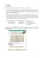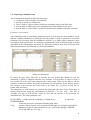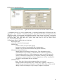
1
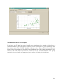
USER MANUAL
CENTRE FOR ENVIRONMENTAL RESEARCH
LEIPZIG – HALLE
IN THE HELMHOLTZ ASSOCIATION
0
www.bdf.ufz.de/CANDY
CANDY
windows version 2.4
CONTENTS
1. Introduction.............................................................................................................................................................2
2. First steps......................................................................................................................................................... ...... 3
2.1. Installation......................................................................................................................................................3
2.2. Preparing a simulation run.............................................................................................................4
Parameter environment.............................................................................. ............................4
Climate data.....................................................................................................................................5
Definition of simulation objects.......................................................................................6
Basic information.........................................................................................................................7
Management data.........................................................................................................................8
Experimental values...................................................................................................................8
Creating and deleting items..................................................................................................9
2.3. Start of simulation runs...................................................................................................................10
2.4. Result evaluation....................................................................................................................................13
2.5. GIS-support.................................................................................................................................................17
2.6. Simulation runs for several plots
21
3. Batch file settings..............................................................................................................................................22
4. Background information............................................................................................................................23
4.1. ACCESS-Tables in cdyprm.mdb..............................................................................................23
4.2. User tables in DBF-format.............................................................................................................27
4.3. Files in the CANDY directory.....................................................................................................29
4.4. GIS-database..............................................................................................................................................30
5. Example with comments................................................................................................................................32
Introduction of the user interface (data input).....................................................32
Standard simulation..................................................................................................................39
Simulation in GIS mode.......................................................................................................45
Developing management strategies for N-fertilization...................................50
Developing management strategies to optimize
the organic carbon input........................................................................................................52
1
1. Introduction
CANDY simulates the dynamics of Carbon and Nitrogen in the unsaturated (vadose) zone of
agricultural used soils. The model application should preferably be focused on sites with a
rooting zone of up to 2m. The soil profile is divided into homogeneous layers of 1 dm. The
simulation proceeds in daily time steps. Starting from initial values for all variables the model
simulates the impact of management and climate on them. The following processes are
included:
• Climate conditions (access to database or generating climate date , correction of
systematic errors of observed precipitation)
• soil water dynamics (pot. and act. evapotranspiration, percolation through soil)
• soil temperature dynamics
• turnover (mineralisation and humification) of organic matter in soil
• nitrogen dynamics (mineralisation, immobilisation, uptake, leaching, gaseous
losses, symbiontic N-fixation)
The system consists of a user interface that organises the access to the data and the
preparation of simulation tasks and the simulation model itself. A simulation task consists of a
site description and the scenario data. The site description includes the parameters of the soil
profile – that is for each horizon at least:
•
bulk and substrate density
•
soil moisture at field capacity and wilting point
•
texture indicator (particles < 6µm)
•
saturated conductivity
and the time course of climate data (daily time steps)
•
air temperature at 2m (°C)
•
global radiation (J/cm²)
•
precipitation (mm),
The scenario data consist of a description of initial conditions. These can be reconstructed
from detailed observations but should include at least
crop rotation and average yields before initial point
•
relative filling of field capacity
and the farming activities (management) on the field:
• soil tillage and irrigation
• application of mineral fertiliser and organic matter,
• sowing(emergence) and harvest.
•
The model has successfully been evaluated with different site conditions and scenarios.
Results are of course depending on the quality of input data. If high quality input data are
available the model error is about 2 VOL% and 20 kg/ha mineral nitrogen.
2
2. First steps
2.1. Installation
Follow these instructions to install a CANDY system on your computer:
1.) If you have already a Βorland Database Engine (BDE) installed on your computer, then be
sure to have the configuration file saved to be able to reconstruct this state on your PC. To
do that, you have to start the BDE-Administrator and save the current configuration with
Object > save as Configuration.
2.) Run setup.exe from the installation CD and follow the instruction shown there. It is
important to launch the program at the end of the installation process (don’t uncheck the
option). This runs a batch file register.bat which first registrates some important DLL
files and afterwards launches the CANDY user interface. If the registration is finished
successfully you don’t need to start this batch file any more.
3.) After a successful installation you will find new software on your PC:
- the user interface
CDY_UI.EXE
for data processing
- the CANDY model
WCANDY.EXE
for process simulation
- the import module
DB_IMPORT.exe
to exchange data with other
CANDY users
To start the system launch CDY_UI. Then click on the appropriate buttons to run the single
modules. The buttons with a ‚?‘ label give you the opportunity to change the directories for
your data pools.
3
2.2. Preparing a simulation run
Any simulation run should include following steps:
• verification of the parameter environment
• provide or check-up climate date
• select a field or a plot in order to define the simulation object (plot Selection)
• provide data on farming activities (management module under plot selection
• provide data on observations (optional) (measurement module under plot selection)
Parameter environment
Any simulation result is based on the parameters used. As a first step the user should be verify
that the available parameters are fitting the special purpose. It may be possible to extend the
parameter files provided with the installation software or to adapt single parameter values
according to local peculiarities. It is strongly recommended to lock at the description of model
algorithms before changing the parameter set. Sensitivity analyses may help to find the most
important parameters to be adapted to your local conditions.
editing soil parameters
In nearly all cases users will have to describe the soil profile that should be used for
simulation. CANDY is shipped with only few examples of soil profiles. In order to create a
new profile, fill in the new name and press the create button. Than you are able to edit the
sequence of horizons and the soil physical parameter of each horizon. If you want to insert a
new horizon record you can move the cursor to an empty line ( [↓]-key) or click the [+]
button with you mouse.
The parameters of each horizon are listed on the right hand side of the form. Soil texture is
mainly characterised using the concentration of particles < 6.3 µm (clay + fine silt). If
available you may as well add the values for clay and silt, but this is not necessary for
simulation runs .The other parameters are:
PLOUGHED: 1:tillage horizon, modelling of OM-turnover,
0: otherwise
HYDROMORPH:
if checked: horizon is permanent saturated with water
Corg:
organic Carbon content (only required if SOM impact on soil physics should be
simulated, in this case the parameters K_xxx specify the changes of BD,SD,
FCAP and PWP per 1% Corg .)
4
BD:
SD:
FCAP
PWP
NIN0
Ks
HCAP
bulk density in g/cm³
substrate density in g/cm³
field capacity in VOL%
permanent wilting point in VOL%
standard value (level 2) of Nitrate-N (in kg/ha) in a 1 dm soil layer., K_NIN gives
the changing of this amount per level
saturated conductivity in mm/d
heat capacity of soil substrate (0,16)
climate data
For the whole time interval of the simulation scenario the climate data has to be provided in
daily time steps without any gaps. Practice shows that temperature and radiation data can also
be used from distant stations, but precipitation data should be used from a local data set.
Climate data have to be provided in dbf-files with following name convention.:
WETsssjjjj.dbf;
with sss:
station shortcut ( linked with fix-data)
jjjj:
year ( in 2 or 4 number format )
climate data module
The module ‚climate data‘ is a possibility to edit or verify the climate data. Of course you
could as well use other tools to compile the data. The table –view of the selected climate data
file supports also pasting of data from other sources. This has to be done separately for each
column. Copy the data to the clipboard as usual and then click the right mouse button on the
first (upper) cell where you want to start the pasting and click on the paste command of the
appearing context menu.
5
Definition of simulation objects
Module ‚plot selection‘ – right-click on tree-view-items to activate context menus
A simulation object is a plot or subplot that is considered homogenous. Different plots are
aggregated in a database consisting of: fixed data (FDAxxxxx.dbf), management data
(MASxxxxx.dbf), measurement data (MWExxxxx.dbf), data about plot history concerning
cropping and manure application (MMHxxxxx.dbf), results from manure/slurry analysis
(GUExxxxx.dbf) and data about the system state that can be used as initial values
(S__xxxxx.stc [binary file]).
A simulation object is defined by its fixed data:
name of the plot
soil profile (selection from popup)
climate data:
- climate station (selection from popup)
- long term average of precipitation and air temperature
- latitude ( only to transform sunshine into global radiation)
information about plot history:
- annual input of reproducing Carbon(Crep): This information can be
calculated from crop rotation, yield and amount of manure application.
- N input and moisture level: this information is used to select site specific
values for mineral soil nitrogen or soil moisture according to the farming
intensity as a rough estimation. A better adaptation to real site conditions is
possible if measurement data are available.
simulation start:
- date ( from here climate and management data are required)
- filling of usable field capacity (uFC) at this time (roughly:: 100% at 1.1.)
- annual nitrogen input from atmosphere in kg N/ha. This value will be varied
during a season according to crop coverage (roughly: 60 kgN/ha)
6
basic information
The Basic-Info tableau shows all data describing the plot ore the simulation scenario. These
fixed data are store in the FDA*.dbf file. After editing all fields you should press the
updateFDA button to save your data. If you want to use status file support (recommended)
you should as well press the create status button. The status calculation is based on the
History data, the selected soil profile and the biological active time that will be calculated
from soil texture, temperature and precipitation. If you change these data you should create a
new status record in any case ! There are some crucial data on this tableau – which means that
they are hard to estimate.
N-deposition: Whilst many agricultural advising services deny a considerable diffuse input of
nitrogen from the atmosphere there is experimental proof of the relevance of this
matter flux from long term experiments. Most European long term experiments have a
control plot with an annual nitrogen offtake of about 50 to 60 kg/ha without depletion
of soil. To enable this nitrogen in crop production you have to set the N-deposition
rate to a similar value.
moisture level: If you start the simulation in the beginning of a year in most cases a 100%
filling of field capacity is a wise estimation. If you start after harvest it needs local
experience to guess a reasonable value. Anyway it would be best to have observations
of soil moisture dynamics. In this case you could use the measurement data to adapt
the model and to validate your soil parameters.
N level: Similar to the moisture level the best way of system adaptation in terms of mineral
nitrogen would be based on measurement data. If they are not available you depend on
local expertise to estimate this value. Since this is an indicator 1 stand for low input
agriculture, 2 symbolises the normal level and 3 shows a high input farming. At run
time the N-level value is used to initialise the mineral nitrogen distribution over the
soil profile. The N-storage (nitrate N) of a soil layer i is calculated after following
equation:
N[i]:= NIN0+k_NIN*(N-level-2)
with NIN0 and k_NIN reading from soil parameters (see there)
C-level: This value (also referred to as Crep) is important toinitialize the proper humus level
of the simulation object. Again – the best way of adaptation would be measurements
of hot water soluble Carbon, decomposable Carbon or organic Carbon (the first and
the last will internally be changed into decomposable Carbon.
If you consider the soil to be near its steady state according the previous land use
(which is the only possible hypothesis if there are no further information and you want
to run a simualtion) the humus level will be calculated from the average flux of
reproducing Carbon – which is entering the SOM – and the estimated biological activ
time. To help you with the estimation of the C-level (which should be about 8..12) you
could start a Crep-calculator clicking the History button. The History-window has a
Croplist (left) and a list of added organic matter (right) – beside harvest residues and
roots. You have to specify type and amount of the items and calculate their abundance
in the crop rotation. If manure was applied at a rate of 300 dt/ha every 3 years you
should specify 300 and 33% - or 100 and 100%. The coresponding Crep-value will be
calculated and used in the basic-info after closing the History window.
7
management data
editing management data
Select the management tableau to edit the farming activities for your simulation scenario.
Click on a record in the table, change the information using the fields on the lower part of the
form and press the insert/update button to save your data. If you want to insert new records
you have to click on the appropriate radio button.
experimental values
editing measurement data
Select the measurement tableau in the plot selection module to edit your observation data in
the same way as the management data. If you want the model to fit right through a data point,
you should check the adaptation option. In this case internal model values will overwritten
with the observed value. Usually you won’t check this option and CANDY writes the internal
value into the table to give you the opportunity for an assessment of the simulation results.
8
creating and deleting items
creating a new database:
right-click the uppermost (database) symbol in the tree view and click on create a
new database in the context menu. In the subsequent dialog you have to enter the
name (5 characters) of the new CANDY database.
creating a new plot, deleting plots:
right-click the plots symbol of the database to be extended, select the add a new plot
option in the context menu. If you want to use data from another plot (even from
another database) - open the appropriate tableau (management for management data)
and move the data (drag and drop) from one plot item on the tree view to another.
Select the option delete active plot from the context menu to delete the activated plot
( indicated by a yellow symbol in the tree view)
editing tables of the user data:
Activate the files symbol of the appropriate database and then the table (dbf-files
only) to be changed. You may edit the data directly in the table view. To insert new
records, move the pointer to the last record and press the [↓] key. The data are saved
leaving this record. To delete a record you have to press [CTRL]+[DEL] and confirm
the deleting action. Deleting a record in your FDA table means to remove a plot from
the database, but without deleting the corresponding records in the MWE and MAS
file.
If you want to edit the MW_ table in this way you have to hold down the [ALT] key
clicking on the MW_ item and you will have the table view instead of the evaluation
module activated.
datapath symbol
files (group symbol)
active item
file item
plots (group symbol)
plot item
GISQUEF shp
CANDY database
tree view of the plot selection module
deleting a database:
The context menu of a CANDY database includes this option. There will be a
warning that you are going to delete all plots of this CANDY database.
9
2.3 Start of the simulation runs
This paragraph explains the way you will start simple model runs. There are some more
sophisticated options to mange the simulation for a whole database that will write results into
an ACCESS database. These options (scenario and group simulation) may be activated via the
context menu of the CANDY database in the tree view. (see also 2.6).
In the Basic-Info tableau of the plot selection module you will find the button to run the
simulation model. If the button is pressed the system creates and activates a batch file to call
the simulation model (cndrun.bat). This batch file can be saved and modified by experienced
users in order to run the model without using the interface program.
There are two options to select. The dialog with experimental data (checked on default) gives
you the opportunity to select records from the measurement data that should be used for this
simulation run. Additionally you can create new records (without observation data) to extract
specific results from the model. The records compiled within this dialog will be stored in a
temporary file (MW_xxxxx.dbf).
measurement data dialog
The quick start option is usually unchecked. If you check this option you will immediately run
the model without the opportunity to edit model switches. If the option is unchecked the
model comes up with a window that contains all parameter for the simulation run and some
elements to modify the behaviour of the model.
10
The recommended output format is the RES-file. You may select the results that you want to
be recorded in the selected output frequency during the simulation. RES-files have an ASCII
format and can be used with any text editor. From the user interface you may start a special
viewer for these files with an option to export data into an EXCEL spreadsheet. The name of
the output file can be changed by the user. There will be no warning if a file will be
overwritten during simulation.
standard switches:
presentation mode:
wait after run:
prevent runoff:
generated climate:
producing an additional graphical output during simulation
model window stays on screen after finishing the simulation
no surface runoff occurs, water surplus stays on top
climate data will be generated during simulation; to use this
option, the preparation of a generator file (*.per) is required.
new initial cond.:
model initialisation from fixed data and not from a status record
as usual
SOM in steady state: the initialisation of SOM will be based on the farming activity
during the scenario and not on the Crep value in the fixed data
expert switches
precipitation data not yet corrected (default):
the model compensates the systematic errors of precipitation measurements
change soil physics with carbon content
the model adapts density, field capacity and wilting point according to the
changing Carbon content
risk analysis: repeated run of the same scenario with randomly distributed fertiliser
repeat management scenario: check this option if you want to repeat a 5-year crop
rotation for 100 years and specify 20 cycles
non-default initial conditions:
you may read the initial condition from any file in a *.stc format. Specify the
file name and the record number you want to be used.
message class:
a higher message class will suppress less interesting messages
GIS-mode:
to be checked if the model is used in GIS mode
precipitation adaptation factor:
all precipitation data will be multiplied by this factor
11
A mouse click on ‚start simulation‘ will start the model. In presentation mode you will find
graphical outputs additional to the default simulation protocol, that is written into the ASCII
file candymsg.$$$
In most cases you will not activate the ‚presentation mode‘ in order to save time. You may
stop and continue the simulation at any time and you can calculate for certain time intervals to
watch the model behaviour at certain dates. You may as well cancel the simulation and return
to the initial window.
12
2.4. Result evaluation
All messages about the model activities are stored in a MESSAGE file (*.msg, bzw.
candymsg.$$$). Depending on the settings you will find an fixed data set in text file (*.MXT)
or a user defined result record in the result file (*.RES). It is not possible to have both outputs
at the same time. Start the res-file viewer from the user interface to work with that type of
results. Activate the file you want to analyse, click on go and then you may select the variable
of your interest. You will see a numerical and a graphical representation as well as the
average value of this result variable. It is possible to assign these variables to an x or y set to
perform a simple linear regression.
Click on the export button to move the whole result data set (all variables) into an EXCEL
spreadsheet.
RES file viewer
A more flexible tool for model evaluations is the usage of evaluation module, that will be
activated by a mouse click on a mw_ file on the plot selection module. To do that, you have to
change from the plot to the file level where you should find your MW_-file after a successful
finished simulation run.
comparing measurement and simulation results with the evaluation module
13
In the evaluation module the user has to select plot, property and depth. Measurement values
and simulation results are shown as a table and in graphical format. Data may be moved into
an EXCEL spreadsheet and simulation results can be saved in the MWE file.
If you did not activate to option for new generated initial conditions, the system will initalize
from a valid record in the status file (S__?????.stc). During simulation a new status record is
written before a new year starts and a additional record at the end of the simulation scenario.
The viewer for this file will be activated if you click on a S__-file item:
Whilst this feature might be more interesting for experts, the forecasting feature could find a
more common interest. It is based on the last valid record of the system state and provides an
overview about the nitrogen and water availability as well as a prognosis of nitrogen
mineralisation. To activate this module you have to click the appropriate button on the basicinfo tableau in the plot selection module. This button is only enabled if there are valid status
records available, which is not the case if you let the system create new initial conditions
during simulation. The forecasting feature has two modes of appearance. If there is an active
crop with nitrogen demand you can activate a graphic overview about timecourse of demand
and nitrogen supply. If there is no crop, the forecast will provide a standard estimation of
nitrogen to be leached with 100 mm surplus of water.
14
A crop is recognised, the N amount to be added without exceeding the critical value in
autumn is calculated – if required you may change this value and recalculte
The standard crop view gives information about the nitrogen storage
for different rooting depths
For an active crop, the graphic shows the expected time course of N-demand and supply.
Right-click the diagram to simulate applications of mineral ferilizers
(the amount is calculated according the mouse pointer)
15
Without an active crop the system calculates the leaching probability...
...and the graphic shows the nitrogen breakthrough with the expected nitrate concentration at
the right hand side
16
2.5 GIS-support
CANDY supports the access to GIS data through mapobjects (ESRI). The user should provide
the data as shapefile using ArcView. The filename has to be composed of the prefix ‘GIS’ and
the CANDY database name (5 characters). If your database is called FIELD you should have
the files GISfield.dbf, GISfield.shp and GISfield.shx in your data directory.
The DBF file should at least have following fields:
Field name
Type
Meaning
ID
PATCH
integer
character
FLAECHE
GEBIET
PARZELLE
BODEN
WETTER
R_FAKTOR
real
characters (5)
characters
characters
characters (3)
real
WERT
real
unique identifier of the patch
unique identifier of the patch, used for
result file name
area of the patch in m²
name of the CANDY database
plot name identical with SBEZ in FDA-file
soil profile, should be
pointer to climate station
adaptation of local rainfall to observation at
climate station
template for results
I f you want to extend your data for GIS related simulations you have to activate the option
create GIS support from the context menu of the appropriate CANDY database.
If CANDY recognises GIS data it adds a special symbol in the selection tree of the plot
selection module. A mouseclick on this item opens window with a map view:
Click on a patch and the database button opens the plot selection module to edit this data.
17
With a click on the CANDY region button you will open the window for regional simulations.
There is a
special database for the GIS related results. Usually it is automatically created. The database
structure is described in the chapter 4.4, a template for this database is in the CANDY
directory (GIS_template.mdb).
It is possible to define several simulation scenarios or relate to an existing one. In most cases
you will create a new scenario and the system will tell you the identifier (a number) for the
scenario. This identifier is used as a default to name the result table that will be created if you
click the run button. You have to select the plots to be included in simulation and may edit
starting and ending point of the scenario as well as the results to be recorded during
simulation. The simulation procedure is the same as usual but the rainfall correction factor of
your GIS data will be used. It is possible to set switches according to the problem to be solved
and you can decide to create new initial conditions from the FDA parameters or tell the model
to use initial conditions from a STC-file. The recorded results and the frequency of the
outputs has to be defined similar to all other simulations. After changing scenario parameters
press the update button to save the settings in the database.
The model run will include all selected items. After a successful simulation run you may
evaluate the output data in the ‘results’ tableau:
18
After selecting the scenario and the result attribute you will see the data in the result table and
also as a distribution plot:
Doubleclick an item in the table or in the plot to add it to the list of selected objects. For these
objects together with the regional average the dynamics over the whole simulation intervall
will be shown after clicking the button ‘show dynamics’.
19
Clicking the button ‘ show map’ will produce a map view for the selected attribute. Colouring
of the classes can be changed after doubleclick on the colour in the legend table.
The GIS database provides space for up to 10 variables for a statistical analysis. Starting a
new analysis you should clear these tables ( ‘reset stat’ button). New items will be added after
clicking the ‘add 2 stat’ button. Within the statistics tableau you can create an x-y-plot from
this variables and export the whole dataset to an EXCEL file for further analysis.
20
.
2.6 Simulation runs for several plots
If you have no GIS data but want to bundle your simulations for a number of plots from a
CANDY database, you could activate options scenario simulation or group simulation from
the context menu of the CANDY database in the tree view. There will be a list of all plots
shown, where you can have a selection for the simulation run. The scenario simulation is very
similar to the GIS mode and will save results too in an ACCESS database. The group
simulation is more simple and aggregates just a number of simple plot simulations.
21
3. batch file settings
model switches: ( all switches have a +/- option; the following settings are the non-default
ones ; if a switch is not used in the model call at all, the default setting will be active anyway)
V+:
N-uptake proportional to transpiration, default VD+:
adapt soil physical properties to Corg , default DZ+:
generated climate data, Default Z- (real climate data)
S+:
generate initial conditions from fixed data, no status file necessary
(S__xxxxx.STC), default SW-:
no stop after simulation run, default W+
G+:
simulations in GIS mode, default GP-:
no graphical results during simulation, default P+
parameters:
general information
DP=
data path (e.g. C:\CANDY\CANDY_DA)
WP=
path to climate
RP=
path to result files (*.res).
Z=
if assigned, the system will repeat simulations for the specified number of
years circulation through the management data.
MC
MessageClass: determines the messages selected for output
RAnn
risc analysis with nn replications of the scenario
SS
steady state : (only effective with S+)
Initial values for SOM are calculated from scenario data and not from Crep in
fixed data
OF=
output frequency for simulation results( MXT and RES files).
possible options are 1, 5, 10, 30 (for month) - annual is default
description of the simulation scenario
A=
start date (A=dd.mm.jjjj)
E=
end date(E=dd.mm.jjjj)
X=
MXT-file name( without extension).
R=
RES-file name( without extension).
P=
name of soil profile
D=
name of database (xxxxx). Basis for following file names:
MASxxxxx.DBF : farming activities (management)
FDAxxxxx.DBF : Basic Info (fixed data)
MW_xxxxx.DBF : subset of MWExxxxx.dbf to be used for simulation
S=
plot index: nnnnu
with nnnn: plot number ( SNR field in DBF's) blanks have to be replaced by a
low line – and subplot (UTLG field in DBF's); e.g.: __123: snr=12, utlg=3
W=
name(abbreviation) of climate station (sss). depending on the Z switch the
following file names will be constructed: Z+: climate generator sss.PER /
Z-:real climate data from WETssjjjj.DBF ; jjjj: year
22
4. Background Information
4.1 ACCESS-Tables in CDYPRM.mdb
Soil Parameters
(Profiles: profile)
Parameter
PROFIL
HORIZONT
HORIZ_NAME
(Horizons: CNDHRZN)
Parameter
NAME
HYDROMORPH
PV
KRUME
CT
TRD
K_TRD
TSD
K_TSD
PWP
K_PWP
FKAP
K_FKAP
KF
LAMBDA
HKAP
TON
SCHLUFF
FAT
NIN0
K_NIN
Meaning
name (abbreviation) of the profile
depth ( lower limit of the horizon in dm)
pointer to a record in CNDHRZN
Meaning
horizon name ( refers to profile.HORIZ_NAME)
(yes/no) yes: horizon is always saturated with groundwater
pore volume ( not required )
switch : KRUME=1 means ploughed horizon
typical value of Corg-content in %
(reference basis for TRD, TSD, PWP and FKAP)
bulk density in g/cm3
change of bulk density per 1% Ct
substrate density in g/cm3
change of substrate density 1% Ct
permanent wilting point in VOL%
change of wilting point per 1% Ct
field capacity in VOL%
(good estimate soil moisture in spring time)
change of field capacity per 1% Ct
saturated conductivity in mm/d
seepage parameter after Glugla (facultative)
heat capacity (i. a. =0.16)
clay content (facultative)
silt content (facultative)
content of particles <= 6.3 micrometer:= clay+fine silt
Nmin-standard per 1dm soil at normal N-supply in kg/ha
change of Nmin-standard per intensity level in kg/ha
23
Pesticide parameters
(CDYAGCHM)
Parameter
ITEM_IX
NAME
INDEX
H
DIFAIR
VOLGRE
DEC_COEF
TEMPERATUR
KOC
FRN
Parameters for OS-turnover:
(CDYOPSPA)
Parameter
ITEM_IX
NAME
CROP_IX
OD
K
ETA
CNR_ALT
CNR
TS_GEHALT
C_GEH_TS
MOR
Meaning
Index
name of pesticide
unique number ( e.g. CAS-registry number)
Henry – constant ( J/mol)
Diffusion coefficient in air (cm²/d)
height of the borderline between soil surface and clean atmosphere in cm
decomposition coefficient in 1/d
reference temperature for DEC_COEF in °C
KOC-value in mg/kg
Freundlich –exponent
Meaning
Index
name
crop index
organic matter for application (manure, slurry) (true/false)
decomposition coefficient
synthesis coefficient
total C/N-ratio
C/N-ration in organic matter
dry matter content t
C-content in dry matter
relation between mineral and organic Nitrogen
Parameters for mineral fertiliser
(CDYMINDG)
Parameter
Meaning
ITEM_IX
Index
NAME
name of fertiliser
AMMNANTEIL
part of NH4-N- in total N in %
24
Parameters for crops :
(CDYPFLAN)
Parameter
ITEM_IX
EWR_IX
GRD_IX
NAME
ART
CZEP
ZETB
MODELL
TRANSKO
VEGDAU
STEIL
NBOK
LNUB
FEWR
CEWR
WTMAX
WWG
DBHMAX
N_GEHALT
DBGMAX
BHMAX
MATANF
BGMAX
TEMPANF
Meaning
Index
pointer to a record in CDYOPSPA to characterise harvest residues and roots
pointer to a record in CDYOPSPA to characterise aboveground biomass after
ploughing up
name
plant characteristic:
non legume crops:
1: annual plant; 2: two year crop (winter wheat) 5: durable crop
legume crops
3: annual plant; 4:durable crop
specific interception capacity (overwrites default in CDYAPARM)
parameter of withdrawal function (overwrites default in CDYAPARM)
model algorithm, default: CANDY_S
transpiration coefficient (only used with V+ setting and CANDY_S model)
days from emergence to maturity
parameter of N-uptake function
for legumes: constant N-uptake rate from soil
for legumes: part of N accumulated in deep soil
Prop.factor between N in harvest residues and roots and N yield
N-amount in harvest residues independent from yield
maximum rooting depth
days for 10 cm root growth (depth)
days from emergence to maximum crop height
N-concentration in yield
days from emergence to maximum crop coverage
maximum crop height
days from starting maturity to harvest
maximum crop coverage (0..1)
days from emergence to beginning influence on soil temperature
25
general parameters
(CDYAPARM)
Parameter
ITEM_IX
NAME
PARMSATZ
BT_MODELL
N_IM_SOM
N_IM_BEW
K_AOS
K_AKT
K_STAB
K_DENI
K_MULCH
MAXDENI
CNR_OBS
CZEP
XSI
NUNB
TBED
TUNB
ZETU
ZETB
DISP_KF
DNG_EFF
organisation parameters
(Results: RSLTOBJ)
Parameter
OBJEKTNR
RESULTAT
FLEN
DEC
AUSWAHL
Meaning
index
name
name of parameter set
index of soil temperature model
adaptation of N-immission during summer season
adaptation of N-immission for cropped soil
decomposition coefficient (active OM)
activation coefficient (stabilised to active OM)
stabilisation coefficient (active to stabilised OM)
denitrification coefficient
decomposition coefficient of mulch layer
max. denitrification rate
C/N-ratio of decomposable OM
interception capacity of a crop in mm/ m crop height
parameter of transpiration submodel
max. evaporation depth in dm
ratio PET/VTurc for covered soil
ratio PET/VTurc for bare soil
parameter of evapotranspiration submodel (crop covered soil)
parameter of evapotranspiration submodel (bare soil)
weighing factor for dispersion effects; 0..1 (0: no dispersion)
fertiliser effect (usual value :1) . be careful, all applications of mineral
fertiliser N will be multiplied by this factor during simulation.
Meaning
Index – don’t change this !!!
name of result
column with in result table
decimals
selection mark. if selected: '*'; otherwise ' '
( measurement attributes: CND_MWML)
Parameter
Meaning
MERKMAL
alpha index
BEZEICHNUNG
name/property
KURZBEZ
abbreviation
INDEX
numeric index
EINHEIT
unit
26
4.2 User tables in DBF-Format
(xxxxx: database name)
fixed data /basic info FDAxxxxx.DBF
Name
SBEZ
SNR
UTLG
GEOBREITE
STANDORT
WETTER
STATUSANF
STATUSEND
SIMSTAND
STARTDAT
IMMISSION
LTEM
NIED
CREP
NLEVEL
NFK0
Type
C
N
N
N
C
C
N
N
D
D
N
N
N
N
N
N
Length
30
3
1
6
10
3
4
4
8
8
5
5
5
6
5
3
DEC.
0
0
0
1
0
0
0
0
0
0
1
1
1
1
1
0
Meaning
plot/subplot name
plot number
subplot number – usually 0
latitude
pointer to soil profile
pointer to climate station
first valid status record in S__xxxxx.stc
last valid status record in S__xxxxx.stc
next date to be simulated
minimum data to start a simulation
anual N-input from atmosphere in kg/ha
long term average of air temperature (°C)
long term average of precipitation (mm)
long term average of reproducing carbon input (dt/ha/a)
N-input level before simulation
filling of field capacity at STARTDAT
manure/ slurry analysis GUExxxxx.dbf
Name
DATUM
TS_GEHALT
NT_GEHALT
CT_GEHALT
STALL
Type
D
N
N
N
C
Length
8
5
5
5
1
DEC.
0
1
1
1
0
Meaning
date of analysis
dry matter content in %
total N-content in %
total C-content in %
stable index
DEC.
0
0
0
0
0
0
0
4
1
0
4
0
Meaning
'*': start of a serie; else ' '
plot
subplot
sampling date
index in CND_MWML
upper soil layer
lower soil layer
value
variance
replications
simulation result
'J': model adapts to observation
'N': model writes S_WERT
measurement values MWExxxxx.dbf
Name
FIRST
SNR
UTLG
DATUM
M_IX
S0
S1
M_WERT
VARIATION
ANZAHL
S_WERT
KORREKTUR
Type
C
N
N
D
N
N
N
N
N
N
N
C
Length
1
3
1
8
3
2
2
10
4
2
10
1
27
management data
MASxxxxx.DBF
Name
Type
Length
DEC.
Meaning
------------------------------------------------------------------------------------------------------------------SNR
N
3
0
plot
UTLG
N
1
0
subplot
DATUM
D
8
0
date
MACODE
N
2
0
code see CDYACTION
WERT1
N
3
0
quality value
WERT2
N
6
0
quantity value
ORIGWERT
N
10
2
original value
REIN
C
1
0
priority of user values (*)
------------------------------------------------------------------------------------------------------------------* REIN="N" – N-Uptakes and C-Inputs are calculated from model parameters
REIN="J" – user values for N-uptakes and C-inputs will be used instead of model parameters
Interpretation of quantity / quality and original value for different management codes
MACODE
Activity
WERT1
WERT2
0
fallowing
device index
1
sowing
crop index
2
harvest, by-products
removed
crop index
3
org. matter application
OM index
4
fertiliser index
5
mineral fertiliser
application
soil tillage
tillage depth
(dm)
expected Nuptake
(kg/ha)
real Nuptake (*) in
kg N/ha
added
amount of C
(kg C/ha)
ammonium
content%
tillage depth
dm
6
7
Crop cutting
Irrigation
8
pesticide application
substrate index
9
not removed
crop index
10
pasture start
animal index
11
pasture stop
animal index
device index
-
water
amount mm
amount
kg/ha
real Nuptake kg
N/ha
animal
number
animal
number
ORIGWERT
tillage depth (cm)
exp. natural yield (dt/ha)
real yield (dt/ha)
amount of added substrate in dt/ha
total N-input kg N/ha
tillage depth cm
water amount mm
amount kg/ha
real yield dt/ha
------------------------------------------------------------------------------------------------------------------* only if REIN="J"
28
CANDY climate data
file names: WETmmmjj.DBF
- mmm shortcut of climate station
- jjjj year ( with 2 or 4 numbers possible)
all data are daily data !!
Name
Type
Length Dec.
Meaning
------------------------------------------------------------------------------------------------------------------DATUM
D
8
date
LTEM
N
5
1
air temperature at 2 m in °C
NIED
N
5
1
precipitation in mm
GLOB
N
5
global radiation in J/cm² (*)
SONN
N
5
1
sun shine duration in h (*)
------------------------------------------------------------------------------------------------------------------* The model needs only global radiation data. If these are not available they will be calculated from sun shine
duration and latitude during simulation runs.
4.3 Files in the CANDY directory
Dateiname
WCANDY
DB_IMPORT
CND_UI
FDAT
MASSNAHM
MESSWERT
WETTER
GUE
MMH
Type
EXE
EXE
EXE
STR
STR
STR
STR
STR
STR
Meaning
simulation model
module for database transfer between CANDY users
user interface
file template
file template
file template
file template
file template
file template
29
4.4
GIS-database
Table: CDY_RSLT
Name
Type
Size
ITEM_IX
OBJEKTNR
RESULTAT
AUSWAHL
FLEN
DEC
I_TYPE
UNIT
Number (Long)
Number (Double)
Text
Text
Number (Double)
Number (Double)
Number (Byte)
Text
4
8
50
1
8
8
1
50
Table: gisschau (example for an GIS attribute table. the 5 letters SCHAU have to be related to a candy database , this table has
to be imported from the dbf file of the GIS dataset)
Name
BODEN
PARZELLE
FLAECHE
HECTARES
R_FAKTOR
WERT
ID
PATCH
GEBIET
WETTER
Type
Text
Text
Number (Double)
Number (Double)
Number (Double)
Number (Double)
Number (Double)
Number (Double)
Text
Text
Size
25
16
8
8
8
8
8
8
16
16
Name
Type
Size
ID
stc
objekt_id
scenario_id
recno
Number (Long)
OLE-Objekt
Number (Integer)
Number (Integer)
Number (Long)
4
2
2
4
Table: SIM_STAT
30
Table: sim_result, usually named RES_nnn where nnn is the scenario identifier, this table will be created during a simulation
run
Name
Type
Size
id
datum
merkmal_id
objekt_id
wert
Number (Long)
Datum/Zeit
Number (Long)
Number (Long)
Number (Single)
4
8
4
4
4
Name
Type
Size
id
scenario_id
merkmal_id
Number (Long)
Number (Integer)
Number (Integer)
4
2
2
Table: SCE_X_MKML
Table: SIM_SCEN
Name
id
scenario
stc_file
precursor
start
stop
cdy_dat
cdy_wet
cdy_res
res_tab
Type
Size
Number (Long)
Text
Text
Number (Integer)
Datum/Zeit
Datum/Zeit
Text
Text
Text
Text
4
30
30
2
8
8
150
150
150
15
following items are temporary tables that must not be deleted:
Table: tmp_res
Name
Type
Size
OBJEKTNR
Number (Double)
8
Name
Type
Size
serie
element
unit
Text
Text
Text
50
50
50
Name
Type
Size
patch
t
x1
x2
x3
x4
x5
x6
x7
x8
x9
x0
Number (Long)
Number (Integer)
Number (Double)
Number (Double)
Number (Double)
Number (Double)
Number (Double)
Number (Double)
Number (Single)
Number (Double)
Number (Double)
Number (Double)
4
2
8
8
8
8
8
8
4
8
8
8
Table: tmp_stat_desc
Table: tmp_stat_values
31
5. Example with comments
Part 1: Introduction in the user interface (data input)
Start the CANDY programme by launching CDY_UI.exe.
You see the start window CANDY – user interface.
Change the
Data path to:
Climate path to:
Result path to:
C:\Programme\wcandy\example (Press: ?)
C:\Programme\wcandy\candy_we (Press: ?)
C:\Programme\wcandy\example (Press ?)
System Database to
C:\Programme\wcandy\example\cdyprm.mdb ( click button )
32
Providing climate data
Click on the climate data button in CANDY – user interface to check the climate data
(que). For all years/days of your simulation you need climate data (one file per year) in daily
time steps without missing values. You can open a climate data file by double-clicking on the
data file name on the left (see screenshot below). Check the data for the years 2002
(wetque02.dbf) and 2003 (wetque03.dbf) by using the graphics folder.
Please insert the data for the year 2003 from the table below. Therefore you have to change
into the table folder and double-click on the wetque03.dbf file. To edit the climate data in the
table click into the record you want to change and type in the data. You can use the buttons at
the bottom of the window to move through the table, enter and delete records, etc. (for your
information: if you have to create a new file you can use the right part of the window).
DATUM
29.5.2003
30.5.2003
31.5.2003
NIED
0
0
0.7
LTEM
18.7
20.3
17.8
GLOB
2886.2
2879.9
1132.9
Click the return button.
33
Create a new soil profile
One requirement to run a simulation is the definition of a soil profile. Therefore you have to
start the parameters module in CANDY – user interface and click on the folder soil
profiles.
Type the profile name in the edit field to the left of the create new profile button.
Click on the create new profile button. Type the horizon name (horizon1) and the depth (2
in dm) for the first horizon in the edit field in the window where the profile name appears.
Please enter the soil physical parameters for the first horizon (right part of the window) by
clicking first on the default button and then adding the missing data. You will find the data in
the table below. Add the horizon names for all horizons as you see below (horizon1, horizon2,
..., horizon 5). You can use the button + to add a horizon. The data for the other horizons are
already prepared and you will see them after you insert the horizon name or select it from the
pull down menu (two clicks on the right site of the field HRZ_NAME) and click on the ‘9’
button.
34
PRF_NAME
HRZ_NAME
DEPTH
PLOUGHED
HYDROMORPH
Corg
BD
SD
FCAP
PWP
NIN0
Ks(mm/d)
FPA
SILT
CLAY
K_BD
K_SD
K_FCAP
K_PWP
K_NIN
HCAP
Inert Carbon Model
ICP
soil1
horizon1
2
1
unchecked
1.56
1.41
2.6
29.65
15.31
10
492
25.4
0
0
-0.15
-0.045
5
1.5
2
0.16
check
‘Körschens’
0.05
soil1
horizon2
3
soil1
horizon3
6
soil1
horizon4
15
soil1
horizon5
20
These data are already prepared
(select HRZ_NAME from pull down menu and enter
depth).
Click the end button.
35
Defining a simulation object
To define a simulation object you have to start the plot selection in CANDY – user interface.
Activate the context menu (right click) of the uppermost item (data path) and select the option
create a new database. A window will open where you can enter a database name (5
letters/characters). Please enter QUEF_ and click the create button. In the left part of the
window the database QUEF_ should appear. If you click on the + in front of QUEF_ you will
see files and plots. Please add a new plot by selecting the proper option from the plot context
menu (right click on plot). Please double-click on plots (or click +). Please change the plot
name ‘neu’ into Cdec high. Type in the values/names for the soil conditions and
history/initial values from the table below and select soil and weather with the pull down
menus.
NAME
SOIL
WEATHER
N-DEPOSITION
LATITUDE
AIR TEMPERATURE
PRECIPITATION
BIOL. ACTIVE TIME
C-LEVEL
N-LEVEL
MOISTURE LEVEL
START
STOP
Cdec high
soil1
que
57
51.2
8.8
550
32
13.6
2
60
01.01.2002
31.03.2003
36
Input of management data
Click on the folder management. Activate the insert record radio button and select the date,
action, subject and enter the intensity and the C-input (in case of emergence/harvest = Nuptake) for the first record you will find in the table below. Click the insert button. Now you
can enter the next record from the table. Make sure that you are in insert modus and don’t
forget to click insert after every record you enter. You will see the management data ordered
by date. To change a record click the overwrite radio button and select/enter the new data. If
the changes are done, click the update button.
Date
Action
subject
intensity
C-input or
N-uptake
7.10.2002
organic manure
sugar beet leaves
515
3440
21.10.2002 soil tillage
harrow/cultivator
15
----
1.11.2002
Emergence
winter wheat
68
238
24.3.2003
mineral N fertilizer
urea
60
----
20.8.2003
harvest, crop res. Removed winter wheat
68
238
You can print or save (as *.txt-, *.htm-, *.csv-file) the management data by using the print
management button.
37
Input of experimental values
Click on the folder experimental values. Activate the radio button insert record and type in
the experimental values you will find in the table below. Use the insert button to insert the
record into the table.
Sampling date
14.10.2002
14.10.2002
4.2.2003
4.2.2003
Sampling depth
0
2
3
6
0
3
3
6
Observation
Soil moisture (M%)
Soil moisture (M%)
Nmin
Nmin
13.6
12.5
21
14
Now all data are available to run simulation.
38
Part 2: Standard simulation
For the second part we prepared some data which you should use to run the model. The data
are available in C:\Programme\wcandy\candy_da. Please change your data- and resultpath
in the CANDY – user interface start window and change the system database to
C:\Programme\wcandy\cdyprm.mdb.
To start a simulation you have to click on plot selection and select a plot in the left window
(for example __140: Cdec mid). If you don’t see the folder basic-info in the right window
you have to change the folder. At the bottom you will find the button model run (plot).
Before clicking the button make sure that the show dialog with experimental values check
box is checked.
A new window appears where you can select existing experimental values or create new data
to evaluate your model run. Both kinds of data will be written in one output file
(MW_QUEF_.dbf).
39
Click on the folder existing data to select existing experimental values for the simulation.
Select Nmin from the shown experimental values in the upper window and click on the
button use4run. The experimental values will appear in the bottom window.
Change into the folder new data and select the following new data with the pull down menu:
Nmin, monthly, from 1.1.1989 to 31.3.2003, 0 – 3dm, 3 – 6dm, 18 –20dm and
cum. monthly N leaching, from 1.1.1989 to 31.3.2003, 0 – 20dm.
40
Click the run CANDY button. Another window will appear where you can specify your
simulation. Select an annually output frequency and RES-file as output format. With the
select result button you can select your RES-file output data (select all). Change output file
name ‘simres’ into ‘Cdecmid’. Activate the standard switch wait after run. No other
switches should be selected except the default switches in the part expert switches on the right
(see screenshot below). Click the button start simulation.
The CANDY model will run and a window with some information about the simulation will
appear. If the simulation is finished, the information CANDY finished is written in the
information window. Please scroll through the window and take a look at the information
about the simulation.
41
Click the end button.
Save the MW_QUEF_,dbf file (temporary file, it will be overwritten with the next model run
for this plot) in another directory or change the file name (for example: Mid_quef.dbf).
Evaluating results
To evaluate the results click the end button of the database window and click the plot
selection button again. Click on files and MW_QUEF.dbf. The evaluate results window
appear. Please select the plot Cdec mid, the property Nmin and the depth 0-3dm. After that
the simulated data (blue) and the experimental data (green) will appear in the right window
where you can evaluate your simulation. Do the simulated data meet your requirements? Are
they comparable to the experimental values?
42
The simulated Nmin values in 18 to 20dm depth show a high amount of mineral nitrogen in
this depth which is decreasing at the end of the simulation. Take also a look at the cum.
monthly nitrogen leaching. It would be interesting to calculate the nitrogen surplus (Nsurplus = input mineral N + input organic N + input symbiontic N – in crop) for each year of
the simulation to find the reason for this obvious over supply. This you can do with the annual
simulated data from the RES-file. Prior to this, copy the simulated data (Nmin 18-20dm) to
Excel by clicking on the copy to Excel button. The current selection will be copied to Excel.
Click the end button of the evaluate results window and the database window.
To watch the results in the RES-file click on the view RES-files button. The RES-file check
window will appear. There you can select a RES-file (double-click and go), watch the results
(select a property) and copy the whole file to Excel. After transferring the data to Excel you
43
can calculate the N-surplus (see above) and evaluate the different N-fertilizer strategies for the
simulation period. Save the Excel file (Cdecmid_Res.xls).
Please select the property decomposable carbon in the RES-file check window and, after
you watched the results, the property C-REP-flux. You can see that the decomposable carbon
is increasing and that the CREP-level is high (value of 1200 kg/ha is the optimum for the
site). So the organic fertilizer supply should be reduced (see some pages below).
Click on the return button.
Go back to the start window (CANDY - user interface).
44
Part 3: Simulations in GIS mode
CANDY gives you the possibility to use prepared shape files from ArcView. If you have
specific information about an agricultural field (for example: specific soil conditions which
are related to yield) you can create a shape file with defined patches for the field.
You can watch a prepared shape file in CANDY by clicking on GISQUEF_.dbf. A map with
three patches appears. If you click on one patch of the map you can see the corresponding
CANDY plot name on the right. Furthermore, you can change into the corresponding
database (basic information, management, experimental values) for more information.
(Click end and you will come back from the database view to the map view.)
To start a simulation for the map plots click on CANDY region.
45
If this step is gone for the first time, the system tells you a scenario identifier. You should
change the scenario name to TEST and press the OK button to accept the suggested time
interval. Then select the result items for the simulations.
We use monthly outputs of biological activity (BAT), (water)flow to groundwater, Nmineralisation and N-leaching. To save the settings pleas press the button UPDATE
scenario settings.
Click on start simulation and the model will start. After finishing simulation runs the result
data are stored in the GIS related database and can be explored as follows.
46
Use the results page to select the results for a given time interval (usually the whole
scenario). You may decide to use aggregated values (as sum or as average) or the single
results (in our example monthly data). The picture shows the selection of aggregated results
that are ready for the map presentation.
Click on show map and the current results are shown in the map view. Click on CANDY
region and you come back to the results folder.
47
After closing the map view you may have a look at the distribution of the N-Leaching.
Double-Click on a item (dot on the graph or record in the table) to add the object to the list of
selected objects. For these areas you may show the dynamics of the select attribute (click
show dynamics).
This graph shows the comparison of the selected objects with regional average.
48
Now go back to the results page and uncheck the option select aggregated values. Now you
will receive monthly data. Select BAT and then click on add2stat . This will bring the data to
a buffer for simple statistical analyses. This buffer may hold up to 10 different variables. Next
step is the selection of N-mineralisation. Put this data also into the statistics buffer and the
change to the statistics page. There you may select x and y variables and click on show data
to see the dependence between them. In order to evaluate a certain area you could specify the
index of this patch in the highlight patch field and see the data of this patch in pink.
49
Part 4: Developing management strategies for N-fertilization
N-prognosis module
Go to the database window (plot selection). Click on plot __150: Cdec low and then on the
N-prognosis button. In the appearing window you will find some information about the
selected plot, the current nitrogen in the crop and the amount of nitrogen and water in the soil.
The pre-set for the tolerable N-rest in autumn is 60kg/ha. You can change this to another
value by entering the new value and clicking on the button recalculate. For the selected plot
the current maximum environmentally sound N-application until 20.8.2003 is 133kg/ha.
Click on the button show diagram. The prognosis diagram will appear.
There you can decide about some nitrogen fertilization by clicking on a point (nitrogen
amount at a date you choose) on the graph with the right mouse key (see screenshot next
page). A virtual nitrogen fertilization will be added (see window below) if you choose
fertilizer in the appearing menu. Try to place a first nitrogen fertilization of about 65 kg/ha at
the end of April and a second of about 70 kg/ha at the end of Mai. Will this be enough or
would you decide about another fertilization? After your decision about the nitrogen
fertilization please add the mineral fertilization into the management data. Therefore you have
to change to the plot selection (database window) and add the management in the
management folder (see above).
50
Please enter your decision for the mineral fertilizer application for the current plot from the Nprognosis module and run the model until 31.5.2003 (standard run). Start the N-prognosis
module again and watch the diagram. Will there be enough nitrogen in the soil for the plot or
too much? If you have to modify the nitrogen fertilization, change the fertilizer application in
the management data and run the simulation once again.
51
Part 5: Developing management strategies to optimize the organic carbon input
Copy the RES files into an Excel worksheet and calculate means for the average CREP-flux
and biological active time (BAT) for the simulation period. Use these values to estimate the
steady state decomposable carbon (CDEC) according to the following equation:
CDEC = 685.7 * CREP/BAT.
Compare the steady state CDEC with the current CDEC. This will show you the development
of CDEC.
The optimum value for the CREP-flux for the site is between 1000 and 1200 kg/ha. Change
your organic carbon input in the management data and run a new simulation for the plots.
For example: reduce the organic carbon input in the management data for the plot __290:
Cdec high (delete all organic manure applications since 1988 by selecting the data records in
the management folder and press the delete record button) and run the simulation again. How
are the properties (Nmin and decomposable carbon) changing?
52