1
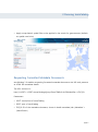
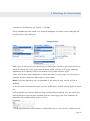
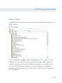
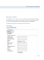
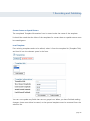
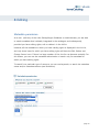
User Guide Version 3.1 Copyright 2011 The lawful acquisition of the sdi.suite software products and their associated handbooks entitles the licence holder to use the products in accordance with the terms and conditions of the licence. Any duplication, resale or use of either the software or this handbook in a manner that does not comply with the terms and conditions of the licence is strictly forbidden and may result in criminal proceedings. Warranty/ Disclaimer Although this handbook has been produced with all due care, errors in detail cannot be excluded. con terra GmbH shall not be liable in any way whatsoever for any damage occurring as a result of using either this handbook or the associated software. Published by con terra Gesellschaft für Angewandte Informationstechnologie mbH Martin-Luther-King-Weg 24 48155 Münster Tel +49 (0)251.74745-0 Fax +49 (0)251.74745-2111 [email protected] www.conterra.de Table of Contents 1 Introduction 1 2 What Is Metadata? 3 3 Running terraCatalog 5 Requesting Formatted Metadata Documents 4 Roll-based Authorisation Concept 6 7 Registration 7 Logging On 7 Roles 7 Groups 5 Searching for Georesources 10 11 Simple Search 11 Using the Map Component for defining a Spatial Search 13 Extended Search 18 Categories (Browse by Theme) 22 GEMET Browser 23 Common Settings for Searches 25 Search Results in the Record List 27 Navigate in the Record List 30 Save and Load Search Queries 32 OpenSearch 35 page iii Content 6 Maps 36 7 Recording and Publishing 37 Issuing a Protection Level 37 SmartEditor 37 Harvesting Metadata Documents 54 Recording Templates 57 8 Editing 59 Metadata permission 59 Statistical Functions 61 Report Functions 64 9 Administration 68 Export Metadata 68 User Management 72 Setting Up Access to External Catalogues 78 page: iv 1 Introduction 1 Introduction terraCatalog is a powerful and scalable metadata management system based on open standards, enabling the capture and serving of metadata for geo-resources. As an easyto-use search engine on the Intranet and Internet, terraCatalog enables quick access to distributed geographic information resources within public or enterprise-wide spatial data infrastructures. terraCatalog supports the search for, and maintenance of metadata via intuitive web interfaces. As well as making locally-stored and managed metadata available to users via standardised interfaces, terraCatalog‟s broker function enables it to integrate external catalogues and data sources in its search for metadata (distributed searching and harvesting). The system implements the OGC CSW 2.0.2 interface, as well as the ISO Metadata Application Profile V1.0 (ISO19115/19119) and the DE Profile for Catalogue Services. terraCatalog satisfies the requirements of the European Commission‟s INSPIRE Directive for the creation of an EU Spatial Data Infrastructure. It provides an INSPIRE Discovery Service interface as well as supporting all INSPIRE metadata elements required for the collection, validation, display and search. With the terraCatalog Connector for ArcGIS product option, users can directly access discovered services and open them in ArcMap. In addition, many alternative map viewer and portal client connections are available that allow the direct transfer and visualization of the retrieved map services. terraCatalog 3.1 – Features Profile Web-based collection, validation and publication of metadata according to ISO and INSPIRE standards Out-of-the-box support for OGC Catalog Service CSW 2.0.2, ISO Metadata Application Profile 1.0 and DE-View 1.0.1 Supports configurable metadata views / custom ISO profiles Searching based on thematic, temporal and spatial criteria Spatial search via a map interface (WMS-based) and Gazetteer (WFS-based) Configurable thematic browser page 1 1 Introduction Connection to the GEMET Thesaurus to assist in searching and creation of metadata Open Search links for direct search in Web Browser Broker functionality, including caching Detailed metadata display with graphical preview Workflow management for metadata publication based on user roles and metadata states Extensive statistics and reporting functions Optional integration of ArcMap and numerous web mapping clients Connection to and invoking of WSS-protected services Quality tested against GDI-DE Test Environment 2.0 Support for ISO 19139 v1.0 (XML encoding of ISO 19115/19119) Documented Client Catalog API News-functionality using GeoRSS feeds page 2 2 What Is Metadata? 2 What Is Metadata? Metadata is the key to spatial data and geoservices. The increasing variety and volume of geoinformation made available from both public and private service providers has made it necessary to find a way of finding and using the information required to solve a problem in a simple a manner as possible. This applies in particular to the increasing amounts of spatial data and geoservices provided in spatial data infrastructures. Typical questions facing the user may be, for instance, „Who has what data available, and in what quality?‟ or „Where can I find a service that is suitable for my requirements?‟. The purpose of metadata is to make it possible to describe geoinformation resources (data, services and applications) in a structured form and through this to make information available to users regarding the content, availability, and quality. Metadata comes into play whenever relevant resources are searched for („discovery‟). A test can be made to ascertain whether the resource can actually be used in a particular use scenario („evaluation‟). Finally, the resource can be accessed („use‟). Classic metadata comprises title, author, collection date, spatial extent and file format information. Geoservices (such as WMS or WFS) are additionally described by metadata which contains technical information on the interface and data access. Geoinformation resources have spatial and temporal references, in additional to the thematic reference, which can be described using metadata. An essential condition for the exchange of metainformation between systems is the use of standards (such as OGC, ISO). These are essentially responsible for describing the syntax, the information model, the semantics, and the identification of the metadata. Standards are laid down by international associations using a process of consensus. The most important standards as far as metadata in the field of geoinformation is concerned are the ISO 19115 (incl. spatial data) and ISO 19119 (geoservices) norms. They are devised by the International Organisation for Standardisation (ISO). They define the structure of metadata in terms of classes and relations and also define the semantics of the metadata elements used. As far as the management of metadata (i.e. searching and maintaining) is concerned, the work of the OGC in the field of catalogue services is of primary importance. On a page 3 4 Register and Login national level, the ISO Catalogue Service Specification Profile plays a central role (CSW 2.0.2 Application Profile ISO 19115/19119) as does the DE-Profile that is based on it. It is by way of these specifications that interfaces for catalogue services are defined, which lay down the way in which metadata searches are performed and the metadata is managed. page 4 3 Running terraCatalog 3 Running terraCatalog Once terraCatalog has been installed and configured on a web server, it can be run in a web browser by entering the web address (URL) of the catalogue provider. All users can select between the following functions: Search Simple Search Extended Search Categories GEMET Browser Settings Maps (optional) Favourites Run mapClient Authentication Once you have run terraCatalog you can search for metadata as a Guest immediately and if you are a registered user, you can log in. Unregistered and new users of terraCatalog can register by clicking 'Register' below the user login. Enter all the required information to obtain a user account for the group 'Guest'. Now you can search for geoinformation or contact the administrator of terraCatalog to increase the functionality available to you. When terraCatalog is run, it first opens with the Simple Search screen. It is possible to perform a search straightaway. However, the following actions are also possible: Enter a search term (with the assistance of an automatic complete), Determine a resource type (application, dataset, service or other), Perform a search against external catalogues, page 5 3 Running terraCatalog Apply a map-based, spatial filter to be applied in the search for georesources (default: no spatial restriction). Requesting Formatted Metadata Documents terraCatalog 3.0 enables requesting formatted metadata documents via URL and presents as HTML like metadata details. The URL structure is: http://<HOST>:<PORT>/terraCatalog/Query/ShowCSWInfo.do?fileIdentifier=<FILE_ID> Parameters: HOST: server/host of terraCatalog PORT: port of terraCatalog FILE_ID: ID of the metadata document, shown in detail metadata (tab „Metadata“ > „Identificator“) page 6 4 Role-based Authorisation Concept 4 Roll-based Authorisation Concept Registered terraCatalog users can benefit from an extended range of functions once they have authenticated themselves. The extended functions are bound to roles and the particular policies associated with them. Registration As a new user, you can register for a user account (click on “Register”). Enter all the necessary information to obtain an account for terraCatalog. You are then a member of the “Guest” group and can therefore only perform searches for metadata. If you wish more functionality, please contact your terraCatalog administrator or provider. Logging On To log on to terraCatalog, enter your user name and password ('Your Authentication'). Roles A non-registered user can take advantage of terraCatalog's search functions (simple search, extended search, categories, GEMET browser and settings) and maps. After registering and logging on, additional functions are available to the terraCatalog user. The roles indicate which policies apply to which user. The following roles exist: tc_Informationssuchender tc_Datenpfleger page 7 4 Role-based Authorisation Concept tc_Redakteur tc_Administrator Searcher (tc_Informationssuchender) In addition to accessing the basic terraCatalog functions (simple search, extended search, browse by theme, GEMET browser and settings), the Searcher is also able to save and open search enquiries from an extended search. Metadata permission: A Searcher has no write or read access to public metadata or metadata of his group. Maintainer (tc_Datenpfleger) In addition to all of the functions that the Searcher has available, the Maintainer is also able to publish data, in other words, he is able to write metadata into the catalogue (SmartEditor, Metadata import) and to edit metadata (Change, Delete). Furthermore, a Maintainer is able to save templates (reusable contact data and predefined spatial extents) and to open them for use. Metadata permission: The Maintainer has write access to any searchable metadata that is visible to him (searching via Metadata permission). In general: read-access: public metadata, metadata of his group, and his own metadata write-access: metadata that is owned by the maintainer himself Editor (tc_Redakteur) The Editor has all of the functions of the Maintainer at his disposal, and he is additionally able to open and view statistics and reports from the catalogue. page 8 4 Role-based Authorisation Concept Metadata permission: The Editor has write access to all metadata that is visible to him (searching via „metadata permission‟). In general: read-access: public metadata, metadata of his group, and his own metadata write-access: public metadata written into the database by a user of his group, also metadata of his group and his own metadata Administrator (tc_Administrator) The Administrator has the full range of terraCatalog functions at his disposal; he has write access to all metadata sets that are administered by terraCatalog, and he is also responsible for harvesting, exporting metadata , and registering external catalogues. In general: read and write access for all metadata in terraCatalog terraCatalog-Connector for ArcGIS (optional product feature) Each of the aforementioned roles can be assigned the role 'ArcGIS Connector'. This makes it possible to additionally equip data and service metadata entries with the necessary information to allow them to be queried directly in ArcGIS. This additional feature of terraCatalog is particularly beneficial whenever central data accessing is possible. User Manager The roles of Group Administrator and Administrator for the User Manager can also be assigned; these are regarded as complementing the central terraCatalog roles. Group Administrator: has access to the user manager but with restricted visibility, i.e. he sees only the members of his group, can create new user accounts for his group and assign roles accordingly. page 9 4 Role-based Authorisation Concept Administrator (user manager): has access to the entire user manager, i.e. he can create new groups, display all registered users and generate new user accounts for all groups accordingly. Groups Each registered user is assigned at least one role as well as exactly one group. It is possible to define groups as company internal or departmental, for instance, but other groupings are also possible. The Administrator is able to create and assign groups however he sees fit. Note: The group to which a user is assigned determines his read and write access to metadata. page 10 5 Searching for Georesources 5 Searching for Georesources With the search formats provided by terraCatalog, it is possible to search the metadata in the terraCatalog metadata database, as well as the metadata in linked catalogues in an external metadata search. terraCatalog offers a quick search function for general search queries, an expert search for specific queries, as well as a browse by theme option for pre-defined categories or the „GEMET-browser‟. A further option is to perform a spatial search. The user can limit the extent of any search to a certain geographic area, using the map component or gazetteer provided by terraCatalog. Note: The terraCatalog metadata search uses the functionality of the underlying database (Oracle or PostgreSQL), but the search criteria are sent via XML, so there are some factors that have to be taken into account when entering characters for search strings. Characters which can cause problems and improbable result sets are: #'&/\´` Please use the single-character wildcard ('?') when required. Example: to search for "flora & fauna" enter "flora ? fauna". Simple Search A simple search can consist of a few entries. page 11 5 Searching for Georesources These parameters can be specified: Select the Type of the Geo-resource Indicates the type of the geo-resource which will be searched for, i.e. datasets, services, applications, and/or other resource types. Searching Using external Catalogue Services In addition to searching in the local terraCatalog metadata database, the user can also search for metadata in remote catalogue services. The terraCatalog administrator will have defined which external metadata catalogues are made available to users to choose from. To select the external catalogues to be used, see Search > Settings. Metadata sets from other catalogues are indicated in the hit list. Inputting a Search Term A text input field is provided for inputting search terms, either individually, or in combinations. The following rules should be noted: The simple search makes no distinction between upper and lower case letters (not case sensitive) Combined terms must always be enclosed in inverted commas: "con terra" page 12 5 Searching for Georesources The use of wildcards for indeterminate characters (*), e.g. *land, North*, *use*, is allowed The use of wildcards for single characters (?) is allowed, e.g. Lond?n. Characters like ? or * as part of the search term have to be prefixed by an exclamation mark to be not interpreted as a wildcard: company!*Star Note! If you put a search term longer than three characters into this field an auto complete function will show all possible and registered keywords of the metadata. Using the Map Component for defining a Spatial Search The search criteria can be further restricted by introducing a spatial filter into the search. The extent of the spatial filter is defined using the map component of the terraCatalog search interface. The user can select a region in the map interactively (Select an Extent, Select Current Extent). This selection is then used as the spatial filter in the next catalogue search. The Gazetteer service can additionally be used to perform a search by location. The results of the Gazetteer search can then be used in a spatial filter. page 13 5 Searching for Georesources Map Component Zoom In Click the Zoom In button and click or click and drag a rectangle on the map to zoom into. Zoom Out Click the Zoom Out button and click or click and drag a rectangle on the map to zoom out that area. Zoom to Full Extent page 14 5 Searching for Georesources Click the Zoom to Full Extent button to display the full extent of the map. Depending on the mapClient‟s configuration it may be a defined initial extent. Back to Previous Map Click the Back to Previous Map button to return to the previous map display. Pan Pan allows you to click and drag the mouse to recenter the map. If you would like to pan the map to one direction, choose one of the Pan buttons arranged around the map. Select an Extent Drag a rectangle on the map. The area selected is indicated by a blue rectangle and the coordinates of this rectangle then will be part of the search query as a spatial filter in addition to the thematic search criteria. The result of this search query comprises all the metadata sets located within the selected spatial extent. Before the search area is defined, it is also possible to zoom into the map, to facilitate the selection of the required extent. Select Current Extent The map component also provides the option of using the current visible map extent for the catalogue search. The entire visible map section is highlighted by a blue rectangle page 15 5 Searching for Georesources and used as a spatial filter in the next search query. Deselect Current Extent The active search area can be deleted with the button 'Deselect Current Extent'. It is then possible to perform a search without spatial restriction. Gazetteer Service In addition to the navigation functions, a Gazetteer Service is also provided. This enables geographic searches to be made based on a variety of preset themes. A theme can be selected from the selection list and a search term entered in the input field. Incomplete words and initial letters can also be used. Note: The search distinguishes between upper and lower case letters. The following examples illustrate the options available: Theme: Federal States (Bundesländer) Input comprises beginning of a word: Sa o Output comprises all states beginning with 'Sa' o Note: A case sensitive search is in use. Input comprises part of a word: „*ach‟ o Output comprises all states that contain the letter combination 'ach' o Note: The wildcard „*‟ is mandatory. page 16 5 Searching for Georesources Start the Gazetteer search; the results of the search are displayed in a list. Select a displayed result (numbered consecutively): the map zooms to the extent of the chosen result and the coordinates are used in the spatial filter (blue rectangle). The object itself is highlighted in red onin the map. page 17 5 Searching for Georesources Extended Search With an extended search, you can refine specific search criteria. If you are logged in, you can also save your extended search settings and reuse them (“My stored search queries”). An input field with the name of the search appears below the hit list. The following options are given: External Query „How do you want to search?‟ – The external query option enables the search to be extended to include external metadata catalogues. The federated catalogue services to be page 18 5 Searching for Georesources included can be selected; see “Search > Settings”. If any metadata sets are found in an external catalogue, the name of the catalogue will be indicated in the results list. Categorisation What type of resource are you searching for? Select (geo-)resource types from the list. A search is carried out for all types when selecting either nothing or all types. Selecting „application‟ and „dataset‟ restricts the search to only these resource types. Select one or more topic categories to define the topic for your query. If no list entry is selected, all topic categories will be part of your search. Note! If you are searching only for metadata of the resource type „service‟ this list is disabled. Is „service‟ one of the selected types, you can define which specific service types to search for. Enter keywords into the text field and find corresponding metadata. You can insert your own keywords or use the auto complete function. After typing the third character all keywords still possible will be shown in a list. To find geoinformation with limited or unlimited access you can use the “Limited Access” page 19 5 Searching for Georesources dropdown list. Choosing „unlimited access‟ means the search will be for all metadata entries without access limitations, although perhaps with some other limitation. You can search for all metadata entries with access conditions using the checkbox. Description You can search for entries with query parameters for title, abstract, organisation name, language of the resource, and/or lineage. For resource types like dataset, series and application you can also insert a „place‟ search term. This may be a city, country or continent. The auto-complete function can be employed with the organisation name and place fields. Search for metadata with a defined interval („time extent‟). This can be a period of validity or relevance. page 20 5 Searching for Georesources You can also define a query using a date type, such as the creation date, and search with a temporal connection. Metadata These elements enable you to search the metadata description itself. You can search for language, organisation name, or time settings of metadata. page 21 5 Searching for Georesources Categories (Browse by Theme) When browsing by theme, a search is made based on a directory structure. The metadata sets are then displayed in accordance with their relevance to appropriate categories. You can also search for specific resource types. At upper levels of the hierarchy, it is possible to open up the themes directories. If a topic ( directory or document) is selected by clicking on the title , all the entries associated with or subordinate to this theme are displayed in a results list. page 22 5 Searching for Georesources GEMET Browser The GEMET browser is used to perform searches based on INSPIRE annex themes or the GEMET thesaurus. Click on the INSPIRE Logo to request the INSPIRE themes. A list theme list is then displayed. Click on a theme to perform a search with the theme name as keyword.. Example: if you wish to search for the INSPIRE annex theme 'soil', you would click on 'soil' in the GEMET interface. The search is performed immediately, comparing the keywords of all metadata containing the specified term. When the search is complete, a hit list is displayed. page 23 5 Searching for Georesources A further option is available in the form of a GEMET thesaurus search . Click on the symbol to display the top-level hierarchy of the thesaurus. You can now navigate through the thesaurus hierarchy and select a search term. You can also enter a search term or partial term in the search field. To begin the query, click on the magnifying glass icon or press ENTER. When the search is complete, all the hits from the thesaurus are displayed. page 24 5 Searching for Georesources The selected keyword is at the top of the thesaurus tree (here biochemistry), and more general or related terms are also shown, if available. To perform the search in terraCatalog, select a GEMET keyword and press Search. The search compares the keywords of all metadata containing the specified term. When the search is complete, a hit list is displayed. Common Settings for Searches If you would like to sort the hits of a search by date or title you can decide which order you prefer, see “Search > Settings”. You can also choose which federated catalogues are used when activating the distributed query. page 25 5 Searching for Georesources Get all catalogue services listed or browse for catalogues by category/theme. These functions are given for the catalogue search hits. Show Detail Information See the detailed information for a catalogue service. The details can also be printed out ( ). Add Federated Catalogue Registered catalogues that can be included in distributed queries will have this function if they are not already in the list of distributed catalogues. Click the button and the catalogue will be listed above. page 26 5 Searching for Georesources Search Results in the Record List The results of a search query are displayed in a navigable result list. The location (box) and detailed metadata information for all the metadata sets found can be displayed. In addition, a number of type-dependent functions are offered. page 27 5 Searching for Georesources Show Position The bounding box of the resource will be shown in the map section. Show Detail Information The detailed metadata information can be requested. You can also print out the detailed information and use all functions which are given in the result list ( ). ConnectorArcGIS Web Map Services, ArcGIS Server Map Services and ArcIMS Image Services or datasets can be opened in ArcGIS directly if the optional component is licensed. Note: Not all datasets can be used, special metadata entries are necessary. Export Metadata Set as XML If you are allowed to export metadata, you can export as XML and save the file locally. Open mapClient Web Map Services, ArcGIS Server Map Services and ArcIMS Image Services can be displayed directly in the mapClient . Open Application If the result list contains application resources with a URL, the application can be opened directly in a new browser window. This only applies to applications! page 28 5 Searching for Georesources Show Coupled Services If the metadata results include entries that have associated coupled services, this allows viewing of those services. This only applies to data sets! Download Data If resources (datasets) have required defined parameters, the data can be downloaded. Display Parent Series If one or several child objects are assigned to a parent dataset or data series, it is possible to display the assigned parent metadata sets. Display Assigned Metadata Sets If a record or a data series is defined as a parent metadata record (parent-object) and contains one or several child objects, you can display the associated child metadata records. Edit If you, as a registered user, have editing rights (with the role: Datenpfleger, Redakteur or Administrator) you will be able to edit metadata entries in the hit list, for all metadata to which you have write access. Click on the icon to open an editing session in SmartEditor. Change Owner If you, as a registered user have editing rights (with the role: tc_Redakteur or page 29 5 Searching for Georesources tc_Administrator) you will be able to change the owner or status of records in the hit list, for all metadata to which you have writing access. Hits of external catalogues will be marked with the name of the external catalogue‟s name. Navigate in the Record List The total number of records is indicated above the results list. Clicking a page number will display the page‟s content. Show First/Last Page Jump to the first or last page of the result list. Page Forward/Backward Browse the pages backward or forward. If you requested a distributed search, the performance statistics will be shown. These statistics will inform you about the number of hits per catalogue service and the response time. page 30 5 Searching for Georesources page 31 5 Searching for Georesources Save and Load Search Queries A logged in user can store an „Extended Search‟ query, and open it again later for reuse. Save a Query If you generate an extended search query and obtain at least one hit, you can save this query. Below the result list there is an input field; insert a name to store the query and note the following conditions: The name has to be unique Minimum name length is 3 characters Maximum name length is 15 characters Only alphanumeric characters are allowed Umlauts, space characters, and special characters are forbidden , except for: '_' & '-' Open/Delete a Stored Query „My stored search queries“ – If you already saved a query, a list of all previously-stored search queries will be available via the extended search form. page 32 5 Searching for Georesources Select a query and open it to reopen your stored query settings in the extended search form. Rerun the search parameters as they are or change the settings to begin searching. You can also select or delete a stored search query. page 33 5 Searching for Georesources page 34 5 Searching for Georesources OpenSearch To search using OpenSearch in terraCatalog, add terraCatalog to the list of possible searches (here: Add 'terraCatalog – search for geospatial resources' while the terraCatalog client is open). You will then be able to select terraCatalog from the list and search it directly at any time. Important note: searches must always be with keywords or at least one wildcard (*). page 35 6 Maps 6 Maps terraCatalog uses the con terra sdi.suite mapClient web-mapping application. You can run mapClient as a service visualisation application; however, it is also possible to open it with pre-defined map views and service combinations ('Favourites'). page 36 7 Recording and Publishing 7 Recording and Publishing The SmartEditor is used for recording and managing metadata: Every metadata set is assigned a visibility status for defining reading and writing authorisations. The available statuses are as follows: Public: can be searched and read by all users (including guests) Group: can be read by all members of a group; the group owner and senior users of the group have editing rights. Owner: reading and editing rights are available to the owner and the terraCatalog administrator The Harvest function permits users with Administrator rights to create so-called harvesting jobs, which transfer metadata documents from a web directory into the terraCatalog metadatabase at pre-defined intervals. In addition, they have a powerful import function at their disposal ('Publish > Metadata Import'). Issuing a Protection Level When compiling or importing a metadata set, a visibility status must always be given. This describes the protection level of the metadata set. Who is permitted to find this metadata set? (reading rights) Who is permitted to edit or delete the metadata set? (editing rights) The three basic statuses (public, in the group, and owner) are described above. SmartEditor SmartEditor is a web editor used for creating required core elements (ISO19115/ISO19119 core) and optional elements. It integrates the INSPIRE metadata publication queryables for services and data. The elements of the SmartEditor are shown in the detailed metadata view. page 37 7 Recording and Publishing Create New Document Use the New Document function to open a new metadata document. It is possible to create metadata entries for datasets, series, services, applications and other resource types. The available functions in the editor very depending on the choice of resource. Edit Local File It is possible to open a previously created metadata document with the SmartEditor and to continue editing it. Select the locally available XML file and start the editor. If necessary you can use a stylesheet from the list to transform the metadata into ISO compliant metadata. page 38 7 Recording and Publishing If the XML-file is an ISO-compliant metadata document, no stylesheet is required. Use a Template to Create a Document It is possible to create and save metadata templates (XML files) for use with the SmartEditor. All templates that are available for use will be displayed in a list; highlight a required template to open it with the SmartEditor, or if required, to delete it. Select a template from the list to open the editor, or highlight a template and delete it. page 39 7 Recording and Publishing Note: new templates are created in the editor environment. Run SmartEditor and enter all the parameters for the template. Then select Create Template. The title of the metadata is used as the name of the template. Tip: templates have the advantage that input values can be pre-defined, which means that you can suggest values, such as contact data. This minimises the work involved in collecting metadata. Opening Drafts When performing an editing session, it is possible to save interim work states. Click on Create Draft to generate a new draft. It is at least necessary to enter a metadata title but the metadata document does not have to be valid. A draft is only visible to the person who created it (the owner) and can be reused, completed and published at a later date. page 40 7 Recording and Publishing Create Service Metadata (GetCapabilities Query) Using smartEditor, it is a simple matter to record service metadata of a WMS, WFS, or ArcIMS services. For web map services, ArcIMS image services and web feature services, metadata entries can be automatically derived from the service description (capabilities document) and transferred into the recording environment. Enter the URL of the service and, if using ArcIMS, also state the name of the service. page 41 7 Recording and Publishing Inputting Metadata Elements After SmartEditor has been opened, it is possible to begin entering the metadata into the user screen. The metadata elements have a similar structure to the detailed metadata view. In addition, seven basic functions are made available above the tabulators. Publish metadata You have completed the process of recording a metadata entry and wish to publish it in terraCatalog. Select the protection level (visibility status) for publishing. This function is also used for determining the validation state. If the metadata entry is valid, the Select Status dialogue is displayed. Note: if you have published a service and set the visibility status and the user rights for serviceMonitor, you can link service metadata directly with the monitoring component. In this case, click on Monitor . Save metadata locally in XML format This function is for exporting all the current entries from the user screen into an XML file, which is then saved locally. Save template Click on this icon to create or update a template. The current status (filling rate) is adopted by the template. The name of the template corresponds with the title of the metadata. page 42 7 Recording and Publishing Note: please do not use any special characters in template titles. Save draft The current work status is saved as a draft. This can be completed, updated and published at a later date. Note 1: it is not necessary for a draft to be valid, but at least one metadata title needs to be entered. This corresponds with the name of the draft in the Start with Draft list. Note 2: A draft is only visible to the person who created it. Choose a validator The following validation options can be selected: ISO 19115/19119 validation (default) INSPIRE validation (includes ISO validation) Important note: select a validation and click on Publish to query the current validation state of the metadata entries. The validation reports are displayed above the tabbed display. page 43 7 Recording and Publishing Show startup page of SmartEditor This exits the metadata recording screen and displays the startup page of SmartEditor. Stop the current editing session of SmartEditor The editing process is cancelled, any changes are lost, and an enquiry is displayed as to whether the Editor should be closed. Note: when closing the editor or ending an editing session, a message is displayed saying that all changes will be lost if you close the editor. Tooltips: do you require an explanation for a metadata element? Then hold down the Alt key and move the mouse cursor to the name of the element. An explanation is then displayed. This tooltip consists of a description and the ISO element name. page 44 7 Recording and Publishing Initially, a few metadata elements may be either filled or empty, as determined by the administrator. Accordingly, input interfaces have already been generated for some metadata elements. The following three buttons are used for adding, deleting or editing input interfaces: To collect new metadata elements, click on the respective (+) symbol. The interface is reloaded and a new input tab is displayed for that metadata element. To delete an element, highlight the desired entry and click on the (-) symbol. The purpose of the tool symbol is to provide support in entering data. A relevant input help is displayed, depending on the metadata element; for the hierarchy level this can be the category tree, for keywords it can be the GEMET browser, or for primary metadata, a search. page 45 7 Recording and Publishing Description Record the metadata elements used in the description of the georesource. You can display tooltips for any metadata element. Hold down the Alt key and move the mouse cursor onto the element name. Categorization Record the metadata elements used for the thematic or hierarchical categorisation of the georesource. Access Record the information for accessing the resource. Distribution Record the distribution information for the resource. Quality Record quality information for the resource. page 46 7 Recording and Publishing Metadata Record the descriptive information for this metadata entry. Tips for Publishing Datasets To link a dataset with a service, enter a value under Description > Identifier > Code. This is a free text entry; we recommend using the metadata set identifier of the dataset. The metadata elements for the dataset are completed now; subsequent settings are made in the service metadata. To link a dataset with a parent dataset or parent dataset series: click on the tool icon as shown in the screenshot below to open a search window, in which you can initiate a search for parent metadata entries. The titles of the entries and metadata set identifiers are displayed. Click on the metadata set identifier to select an entry. The ID is adopted and the connection will be active following publication. page 47 7 Recording and Publishing The corresponding icon referring to a dataset or data series, which then contains child entries, will be created and assigned automatically. To define a geodata link for 'Connector for ArcGIS': Under 'Access > Geodata link', a format can be selected from a list. All entries have then to be made for the format. Path entries should be absolute, e.g. C:\tmp\data\beispiel.shp; alternatively, UNC paths such as \\server\data\beispiel.shp are also permitted. Once the entries are complete and correct, the icon is displayed in the hit list, provided the user possesses the relevant rights. Tips for Service Description To provide direct access from the hit list: under Access > Online-Resource, enter the URL of the application together with the Information function. An icon is then displayed in the hit list with which the application can be opened directly in a new browser window. page 48 7 Recording and Publishing Recording Service Metadata Note that the user screens for recording service metadata have fewer parameters. However they also have a number of additional metadata elements. The metadata elements in the thematic and hierarchical categorisation of the service do not have a thematic category. However they additionally display the following elements: Service Type Select the service type for the resource from the list. For example, the following service types are: OGC Web Map Service (WMS), Version: 1.0.0, 1.1.1 or 1.3.0 o OGC Web Feature Service (WFS), Version: 1.0.0, 1.1.0 o GET_SERVICE_INFO ESRI ArcGIS Geocoding Service (AGIS_GEOCODE) o GetCapabilties ESRI ArcIMS (ARCIMS), Version: 9.1, 9.2 or 9.3 o GetCapabilties OGC Web Catalog Service (CSW), Version: 2.0, 2.0.1 or 2.0.2 o GetCapabilties GetDocumentInfo ESRI ArcGIS Mapping Service (AGIS_MAPPING), Version: 9.3 or 9.3.1 o GetDocumentInfo page 49 7 Recording and Publishing ESRI ArcGIS Mobile Service (AGIS_MOBILE) o ESRI ArcGIS Network Analyst Service (AGIS_NAS) o GetDocumentInfo GetDocumentInfo INSPIRE View Service o GetCapabilities Note: Services have different operations defined. The standard one is the operation of requesting the service capabilities. For each service the operation is given above. It is relevant for getting the mapClient binding for a service. WMS example: ArcIMS Image Service example: ArcGIS Server Mapping Service example: Tips for describing services: Linking to a service with datasets: To link a dataset to a service, an element must be generated for each dataset under Access > Dataset Link. Enter an operation name (as in the Service Operations illustration) plus the name of the Layer or FeatureType (if available). The identifier is defined using a dialog for a separate search. page 50 7 Recording and Publishing Click on the Tool icon to search for a service dataset. If an identifier has been created as defined previously for dataset descriptions, the latter can be linked to here. The Display Linked Service icon is displayed in the hit list. Importing Metadata Authorised users can open locally stored metadata documents in terraCatalog. To access the metadata import function, select Publish > Metadata Import from the menu. You can import new metadata or update existing metadata in terraCatalog using the „metadata import‟ functions. The metadata file identifier is important here. page 51 7 Recording and Publishing The following parameters are entered for importing data: Status Select the protection level of the imported metadata sets. Metadata Owner Enter the name of the owner to be noted in the context of the metadata. Depending on the role that you have, possible selections will be presented to you in a list. Adopt Owner Information Check „Adopt owner information?‟ and the surface elements metadata protection level and owner will disappear. Now it is possible to import metadata with the given user information. How do you obtain owner and visibility information? When exporting metadata you can also export the owner and visibility setting of each metadataset. By combining the modified metadata and owner information it is possible to update the selected metadata without changing the owner/visibility settings. ZIP/XML File terraCatalog also supports bulk importing of metadata documents that are archived in a zip file or a single import via an XML file. Use the Search function to select a locally available zip or xml file and upload it onto the terraCatalog server. The zip file will be extracted upon importing and the metadata sets it contains will then be validated (similar validation for single XML file). In the event of successful validation, the metadata will be automatically published in the catalogue with page 52 7 Recording and Publishing the previously selected parameters. Please note that the zip file must be structured in such a way that an XML file exists for every metadata set to be imported (the names of the XML files are irrelevant). A zip file must not contain any subdirectories, and the name of the zip file must not contain any special characters. Stylesheet file (XSLT) (optional) An XSLT file only needs to be entered if the metadata sets contained in the zip file do not conform with ISO standards 19115 or19119 (CS-W 2.0 ISO 19115/19119 Profile). Select the stylesheet from the list; this will transform the metadata documents contained in the zip file in a manner which is compliant with ISO standards. The transformation is conducted on the server as part of the import process. The current default setting is to provide a stylesheet for transforming an ESRI metadata format to ISO. Please note however that ESRI offers several different metadata formats and that this stylesheet can only be used with one format. E-Mail Address Enter an e-mail address to which messages regarding the progress of the current import process will be sent. These mails contain information as to whether the validation/transformation process has been completed successfully and the data has been successfully published in the catalogue. page 53 7 Recording and Publishing Harvesting Metadata Documents The metadata harvesting function (resource harvesting) adds the ability to conduct the recording of metadata documents in an automatic process when importing metadata (in compliance with the CSW 2.0 ISO 19115/19119 profile schema). At regular intervals, predefined data sources are checked and uploaded (generally by way of metadata documents that are accessible by http) and validated. If successful, the data is then published in the catalogue (with the visibility status „public‟). When using automatic harvesting, transformations can be performed with stylesheets. The function can be invoked in the menu under Publish > Harvest. The following functions in terraCatalog are available: Add job: A new job is added to the current Job Configuration. Delete selected jobs: Highlighted jobs are removed. Start selected jobs: All those jobs selected, will be validated and if they are compliant they will be imported. Delete selected registered jobs: „Overview harvest jobs‟ lists all registered jobs. For each job, the configuration parameters and status are stated. Select one or more jobs, enter your e-mail address, and click „Delete selected registered jobs‟ to remove these harvest jobs. page 54 7 Recording and Publishing Create a new Harvest Job The user is able to create so-called Harvest Jobs (see „Job Configuration‟). The following parameters are to be stated for each job: Source (as URL) In order to make use of the harvesting function, it is first necessary to state the data source to be used as the basis of the harvesting job. This data source should be a single, XML-based metadata file. Stylesheet If the data source is not available in the required ISO format, it is possible to select the necessary document from the list of pre-configured stylesheets. page 55 7 Recording and Publishing Interval State the time interval after which the data source harvesting process is to repeat. This is the amount of time between successive queries. The interval should be given in days. E-Mail Address By providing an e-mail address, an Administrator can keep informed as to the status of the harvesting processes. Status messages include information on the success of a validation process, and whether the respective data was successfully published in the catalogue. To begin the harvesting process, click on the button „Start selected jobs‟. An instance of the harvesting process is performed instantly, and the process is repeated at the defined intervals. Tip: instead of entering individual XML files, it is also possible to use a so-called bulk file (*.mls). This comprises a bundle of different XML files. Example: <?xml version="1.0" encoding="UTF-8"?> <MetadataListing baseUrl="http://localhost:8080/collection/"> <MD_Entry>04_ESRI_data.xml</MD_Entry> <MD_Entry>05_ESRI_data.xml</MD_Entry> <MD_Entry>06_ESRI_data.xml</MD_Entry> </MetadataListing> page 56 7 Recording and Publishing Recording Templates As a registered user (i.e. a user with any of the following roles: Datenpfleger, Redakteur, or Administrator) you are able to record templates of contact data and spatial extents and to use this data repeatedly when recording metadata (with SmartEditor). A template can be seen and used by all users with write-access. page 57 7 Recording and Publishing Create Contact or Spatial Extent The completed Template Information form is stored under the name of the template. It should be noted that the titles of the templates for contact data or spatial extents must be unambiguous. Load Template If an existing template needs to be edited, select it from the template list (Template Title) and load it into the relevant space in the form. You can now update any fields that are not greyed out. When you have finished making changes, these must either be saved, or the opened template must be removed from the selection list. page 58 8 Editing 8 Editing Metadata permission As a user (with any of the roles: Datenpfleger, Redakteur or Administrator) you are able to search metadata that is already integrated in the catalogue, and subsequently, provided you have editing rights, edit or delete it in the hit list. However, all the metadata to which you have reading rights is displayed in the hit list, and only those items for which you have editing rights will have the Edit, Delete, and Change Owner icons. If there is a large number of hits, the list can become unwieldy. For this reason, you can use the metadata authorisation to search only for metadata for which you have editing rights. To search for a particular type of resource, you can use keywords, or search via metadata owner and/or metadata statuses (see illustration). page 59 8 Editing The hit list from the search only contains metadata entries to which you have editing rights. The following functions can be performed: You can perform one of the following functions on the data that is found: Open SmartEditor (Edit) Edit and update the metadata Delete Metadata Set If you wish to remove the metadata from the catalogue, it is necessary to run the Delete function for the relevant metadata entries. A safety query protects against unintentional deletion. The results list is then updated and the number of hits reduced accordingly. Change Owner Information Information on the selected metadata entry is displayed, including the current owner and the visibility status. A list of possible owners is displayed in the form of a selection list. If you wish to select a new owner and/or modify visibility, enter the respective values, and save your changes. Note: This function is only available to Editors (Redakteur) and Administrators. page 60 8 Editing Statistical Functions terraCatalog records all the enquiries made by its users and makes them available to Editors (Redakteur) and Administrators in the form of access statistics. Two types of statistics are available for examination: Ranking of Hits: what metadata documents are requested and how often? Search Criteria: which keywords are used in search queries and with what frequencies? The aim of these statistics is to allow users to optimise both their metadata management and the nature of their queries and hits. Each instance of accessing the detailed metadata of a metadata entry is registered in the statistics. Ranking of Hits After selecting Ranking of Hits, enter the time period for which you wish to create a statistical summary and then click send to create a statistics report. page 61 8 Editing The statistics table which is then displayed shows how frequently the detailed metadata from entries in terraCatalog are queried. The table also shows which organisations are among the most commonly queried data, services and applications. page 62 8 Editing Search Criteria After selecting Search Criteria, enter the time period for which you wish to create a statistical summary and then click send to create a statistics report. page 63 8 Editing The table contains all the search terms entered within the defined period, resulting in the querying of detailed metadata. On the basis of this information, you can optimise your existing metadata sets or new metadata entries. Report Functions terraCatalog records all metadata entries and as Redakteur or Administrator, you also have access to them in the form of metadatabase reports. There are two types of report that can be obtained: Metadata Enabling Status: What proportions of the metadata have each of the protection levels Public, Group, and Owner? Catalogue Refill Grade: Which metadata elements are defined and with what frequencies? page 64 8 Editing The aim of these reports is to allow users to optimise both their metadata creation and the nature of their queries and hits. Metadata Enabling Status This report shows the distribution of the protection levels throughout the entire stock of metadata (in %) and also indicates the number of metadata entries for each visibility level. In addition to the standard enabling statuses, the table also shows how many metadata entries from external catalogues are included and cached in the catalogue (federated). page 65 8 Editing page 66 8 Editing Catalogue Refill Grade All the metadata elements (as per ISO 19115 and 19119) that are contained in the terraCatalog data entries are listed. The refill grade of these elements is displayed (in %); this shows the frequency with which a particular metadata element is stated in the entries. page 67 9 Administration 9 Administration The following functions are bound to the Administrator role. This means that the functions will only be available to a user who logs on with Administrator rights, and who is registered in the terraCatalog user manager with the role of Administrator. Export Metadata Enter a database filter into the text field and export metadata. You can only export metadata or a combination of metadata and user/visibility information for each hit. If the option „Count only hits‟ is chosen the export module will only display how many hits matches with your query. page 68 9 Administration The export module requests metadata document form the database by sending predefined SQL statements. The user completes such statements by entering the remained WHERE clause in the text field. This technique can result in the following exports, for example: All metadata: no WHERE clause All services: type = 'service' All metadata of owner „Administrator“: owner = '1' All metadata of group „Administrators“: ownergroup = '1' All metadata of Web Map Services: servicetype = 'WMS' All metadata including the keyword „hydro“ (case-insensitive): idmd in (select idmdkw from tc_kw where lower(subject) like '%hydro%') All metadata modified after 2010-01-01 (Oracle): modified > TO_DATE('00000001012010','SS/MI/HH24/DD/MM/YYYY') All metadata modified after 2010-01-01 (PostgreSQL): modified > DATE '2010-0101' Full-text search for "mountain" (Oracle): CONTAINS(profilefull,'FUZZY("mountain",60,100,WEIGHT)',1) > 0 Full-text search for "mountain" (PostgreSQL): to_tsvector('german', profilefull) @@ to_tsquery('german', 'mountain') This list of possible exports can get any number. You have the define the specific WHERE clause only. page 69 9 Administration Input the WHERE clause into the text field. Then click „Run export‟ to start. Note: if you do not enter a WHERE condition, all the metadata will be exported. Click „Export user information‟ to export all user, group, and visibility information for each export metadata entry. So for each metadata XML file there will be a second file (*.tcext) which contains this specific information. All files are collected in a ZIP file. Click „Count only hits‟ first, when running the export and only the number of hits (see: 18 hits) is to be presented. All export ZIP files are given below „Existing export archives‟. You can show or hide this list. Click an entry to start the download of that ZIP archive. page 70 9 Administration Note: An export file can be used in a specific way. If you export metadata and the associated user information (as *.tcext files) all metadata documents can be re-imported into terraCatalog as-is. page 71 9 Administration User Management Select the command Administration > Users from the menu to open the user and user group management dialogue in a separate browser window (User Manager). Select the „User Management‟ tab and the three management subdivisions Groups, Roles, and Users are displayed in the user repository, where they can be subjected to management processes. Each of the three subdivisions can be accessed in the tree structure; click on a node to create a new instance. To delete or modify a specific instance, simply click on the respective group, role or user name. page 72 9 Administration Setting Up Users Users are entered and managed together with their account data under Users. Click on the Users node to open the dialogue for recording information for a new account. page 73 9 Administration Personal user data is for informational purposes only. It plays no role either in the authorisation or in the authentication of a role. It is the administrative information which is of relevance. The user requires a user name and password for logging into the system; these must be assigned by the system administrator. In addition to this, each user can be assigned a group and a minimum of 1 role. The assignment of groups and roles is obligatory, since this is the central linking mechanism between the users and their policies. terraCatalog only permits the following user roles: tc_Administrator tc_Redakteur tc_Datenpfleger tc_Informationssuchender tc_Anonymus tc_ConnectorArcGIS Roles are assigned to a user by selecting a role in the Available User Rules field and clicking on Add Role. The assignment can be checked by ascertaining that the role is listed in the Assigned user roles field. Changing and Deleting User Names and Users By clicking on a registered user name in the user repository, it is possible to display the respective user information. The administrator can then perform changes by editing the input fields. For instance, he can assign a new password or add further policies by assigning an additional role. The function Save Changes will cause all changed data to be stored. page 74 9 Administration If you wish to delete a user from the system, select the name of the user and delete it. The user will be removed completely from the user management environment and will no longer be a registered user of the system. Special cases and restrictions regarding users: The user currently logged on cannot delete himself. Users logged on as Administrator or „guest‟ cannot be deleted. A user is member of only one group. Setting Up User Groups User groups allow users to be grouped in a logical structure. In the current version, it is not possible to assign rights to user groups. The assignment of rights is exclusively performed by assigning roles to users. A new user group is created by clicking on the Groups node in the user repository. This opens a dialogue in which the name of the new user group can be entered, along with a commentary for describing the user group. Save the entries to create a new group. A user group can be changed or deleted in the same way that users are changed or deleted. Once terraCatalog has been installed, the following user groups are first of all available: Administrator page 75 9 Administration Guest Special cases and restrictions regarding user groups: Groups can only be deleted when no more users are assigned to them. If an attempt is made to delete a group for which users still exist, a message is displayed showing which users are still members of the group Roles in terraCatalog terraCatalog provides six fixed, pre-defined roles: tc_Administrator tc_Redakteur tc_Datenpfleger tc_Informationssuchender tc_Anonymus tc_ConnectorArcGIS These role names are protected and can not be changed or deleted in the Administrator environment. It is not permitted to attempt to perform changes to role names in the user database directly via the database management system. page 76 9 Administration The role tc_Anonymus is automatically assigned to a non-logged-on terraCatalog user. This means that all users are initially assigned this role after invoking terraCatalog in their web browser. Only by then logging on as a registered user will extended policies become available via the new roles. The concept of roles can be expanded using tc_ConnectorArcGIS. The optional product feature terraCatalog-Connector for ArcGIS makes it possible for users to save a *.csd file for data and services saved accordingly, to allow them to be opened directly in ArcMap. Special cases and restrictions for the User area No attempt should be made to create any new roles in terraCatalog, since this will have no effect on the operation of the terraCatalog application. The various roles are assigned policies according to the following table: Action Role tc_Administrator tc_Redakteur tc_Datenpfleger tc_Informations- tc_Anonym suchender us Simple Search Permitted Permitted Permitted Permitted Permitted Extended Search Permitted Permitted Permitted Permitted Permitted page 77 9 Administration Browse by Theme Permitted Permitted Permitted Permitted Permitted Settings Permitted Permitted Permitted Permitted Permitted Save Search Queries Permitted Permitted Permitted Permitted Not permitted Export Metadata Permitted Permitted Permitted Not permitted Not permitted Start SmartEditor Permitted Permitted Permitted Not permitted Not permitted Import Metadata Permitted Permitted Permitted Not permitted Not permitted Harvest Metadata Permitted Documents Edit Templates Not Not permitted Not permitted permitted Permitted Permitted Not permitted Permitted Not permitted Not permitted Change and Delete Permitted Permitted Permitted Not permitted Not permitted Statistics Permitted Permitted Not permitted Not permitted Not permitted Report Permitted Permitted Not permitted Not permitted Not permitted User Management Permitted Not Not permitted Not permitted permitted Manage External Catalogues Permitted Not Not permitted Not permitted Not permitted permitted Not permitted Setting Up Access to External Catalogues terraCatalog has the ability to search other OGC CSW 2.0 compliant catalogues (basic, ISO 19115/19119, and DE Profile) and to return the results as a general summary (Administration > Federated Catalogues). page 78 9 Administration The catalogues registered here can then be selected for a distributed search under Search > Settings. Adding a external Catalogue The “Add Federated Catalogues” function is used for adding a further external catalogue to be integrated in the search. Please note that before a catalogue can be registered, a descriptive metadata set needs to have been created and the ID provided. If no federated catalogue has been configured yet, an empty table is shown. By clicking a new federated catalouge can be added.. page 79 9 Administration When adding a new catalouge, a dialog is displayed that lists all avaliable catalouge descriptions. In this dialog, all the catalogue are listed that are described in the CSW and not yet bound to another federated catalouge. By clicking you can access the detailed metadata description of the catalouge entry. Choose a catalouge from the list and click „Select“. page 80 9 Administration Essential properties (e.g.. URL) are derived directly from the metadata. Via the connection to the catalouge can be tested. The following parameters must be indicated for a distributed search: Name of federated catalogue This name is displayed in the hit list of metadata entries from the respective external catalogue. The name also appears in the performance display. URL Enter the URL address of the federated catalogue. Caching Select whether or not the metadata is to be subjected to caching, i.e. whether it is to be page 81 9 Administration deposited in a database or called up when queried. Caching Interval (in days) If the metadata in a catalogue is to be stored in a cache, indicate here the frequency with which a new cache should be made of the metadata in the federated catalogue. Caching strategy For all federated and also harvested catalogues you have to select the caching type. Differential means harvesting of the updated metadata only All means harvesting of all entries Protocol State whether the catalogue service is to be addressed by a SOAP binding or POST binding. Profile Which metadata profile is to be used (for terraCatalog 2.x this is always „ISO‟)? Adapter State here the metadata standard in which the entries of the external catalogue are made. This is necessary to enable a transformation to the schema used by terraCatalog (select the adapter). Timeout (in ms) page 82 9 Administration Define the period in milliseconds which terraCatalog will wait for a federated catalogue to respond. Status Should the catalogue be activated or deactivated? Only active catalogues are available for selection under Settings, and thereby available for external searching. E-mail of the Responsible Person Enter the e-mail address of the administrator for that catalogue. A report is sent for each harvesting action. CS-W Metadata Set Create a new metadata set for a federated catalogue via „Create metadata‟. The ID is saved automatically in terraCatalog. Edit a federated catalogue To manage and modify federated catalogues, use the Edit Federated Catalogues function. Select a catalogue from the list of federated catalogues by clicking . You can now effect any required changes and save them with „Save Properties‟. page 83 9 Administration You can extend the table view by clicking . You can sort the table by clicking the column name. Delete a federated catalogue from the list Click in the above dialog. After acknoledging the deletion, the catalouge is removed from the database. The metadata document however remains in the repository. page 84