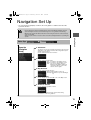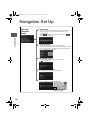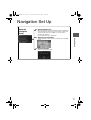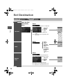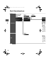
1
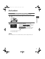
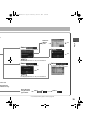
2%:2:9)FSSO4EKI;IHRIWHE]1EVGL41
NAVIGATION
SYSTEM
Preparation
See page 4 for specific information.
Immediate Use
See page 4 for specific information.
Before Use
Getting
Started
Routing
Editing
If Necessary
See page 5 for specific information.
If
Necessary
©2011 Mazda Motor Corporation
Printed in Japan June 2011(Print1)
2%:2:9)FSSO4EKI;IHRIWHE]1EVGL41
Before Use
Accessories
Before Use
Navigation RDM-TMC If
Rear View
Set Up
necessary Monitor
2
Please contact an Authorized Mazda Dealer if you are missing the
following.
lOwner’s Manual
CAUTION:
ALWAYS OPERATE THIS PRODUCT CORRECTLY AS
INSTRUCTED.
DO NOT OPEN COVERS AND DO NOT REPAIR YOURSELF.
REFER SERVICING TO QUALIFIED PERSONNEL.
2%:2:9)FSSO4EKI;IHRIWHE]1EVGL41
Memo
Before Use
If
Rear View
necessary Monitor
3
2%:2:9)FSSO4EKI;IHRIWHE]1EVGL41
Contents
Preparation
n Before Use
Before Use
Accessories........................................................................................ 2
Contents ............................................................................................. 4
Safety Information .............................................................................. 6
Introduction ........................................................................................ 8
(Safe Product Use), (Navigation System), (Screens),
(LCD (Liquid Crystal Display))
Names and Functions ........................................................................ 9
Immediate Use
Navigation RDM-TMC If
Rear View
Set Up
necessary Monitor
4
n Getting Started
l Activation....................................................................................... 11
(Activating the Navigation System), (Setting the Language),
(Setting the Clock, Ambient Temperature Display and Other Settings),
(Upgrading the Map Information Version)
l Menu ............................................................................................. 14
(Navigation Menu Screen)
l Navigation Set Up ......................................................................... 15
l Screen Names and Functions....................................................... 18
(Screens Before Setting Route), (Screens During Route Guidance),
(Adjusting the Map Scale), (Screen Adjustments)
l Character Entry............................................................................. 20
(Street Name, City Name, and Other Input)
l Register Home .............................................................................. 21
n Routing
l Set Destination.............................................................................. 22
(Search Area), (Input City Name), (Previous), (Home), (Memory Point),
(Point of Interest (POI)), (Intersection), (Map)
l Find Local POI .............................................................................. 32
l Cancel/Edit Route ......................................................................... 34
(Cancel Guidance), (Change Route (Delete Destination, Reorder
Destinations, Start from adjacent road)), (Route Preferences)
n Editing
l Edit Memory Point......................................................................... 36
(Add), (Edit), (Delete), (Delete All)
l Edit Home ..................................................................................... 38
(Register), (Delete), (Edit Location)
l Browse Map & Mark...................................................................... 40
(Browse Map & Mark)
l POI Icons on Maps ....................................................................... 41
(POI (Point of Interest) Icons)
2%:2:9)FSSO4EKI;IHRIWHE]1EVGL41
If Necessary
Before Use
n If Necessary
l Precautions/System Performance ................................................. 43
(Voice Guidance), (Repeating Voice Guidance),
(GPS (Global Positioning System)), (Map Matching),
(Positioning Accuracy), (Route Guide), (Route Search), (License)
If
Rear View
necessary Monitor
5
2%:2:9)FSSO4EKI;IHRIWHE]1EVGL41
Safety Information
n Read this owner’s manual for your Navigation System carefully before using the system.
It contains instructions about how to use the system in a safe and effective manner.
Mazda assumes no responsibility for any problems resulting from failure to observe the instructions
given in this manual.
Before Use
n This manual uses pictographs to show you how to use the product safely and to alert you to potential
dangers resulting from improper connections and operation. The meanings of the pictographs are
explained below. It is important that you fully understand the pictographs and explanations in order to
use this manual and the system properly.
Warning
Warning
The presence of this warning symbol in the text is intended to
alert you to the importance of heeding the operation
instructions. Failure to heed the instructions may result in
severe injury or death.
n Do not keep your eyes fixed on the monitor screen or operate the system
while driving.
Warnings
Navigation RDM-TMC If
Rear View
Set Up
necessary Monitor
6
Do not change the settings and destination locations while driving. Minimize the time
spent viewing the monitor screen and listening to the voice guidance while driving.
Operating the system will distract the driver from looking ahead of the vehicle and can
cause accidents. Always stop the vehicle in a safe location and use the parking brake
before operating the system.
n Always obey local traffic regulations.
Your guided route may include roads that are not open to vehicles or are closed due to
traffic regulations. Comply with the local traffic regulations and take another route.
n Do not use the unit when it is out of order.
If the unit is out of order (no image, no sound) or in an abnormal state (has foreign matter
in it, is exposed to water, is smoking, or smells), turn it off immediately and consult an
Authorized dealer, we recommend an Authorized Mazda Dealer. Using the unit in an outof-order condition may lead to accidents, fires, or electric shocks.
n Use the proper power supply.
This product is designed for operation with a negative grounded 12 V DC battery system.
n Do not disassemble.
Do not disassemble the product or attempt to repair it yourself. If the product needs to be
repaired, take it to an Authorized dealer, we recommend an Authorized Mazda Dealer.
2%:2:9)FSSO4EKI;IHRIWHE]1EVGL41
Cautions
n Do not use the product where it is exposed to water, moisture, or dust.
Exposure to water, moisture, or dust may lead to smoke, fire, or other damage to the unit.
Make especially sure that the unit does not get wet in car washes or on rainy days.
n Keep the voice guidance volume at an appropriate level.
Keep the volume level low enough to be aware of road and traffic conditions while driving.
Before Use
Caution
The presence of this caution symbol in the text is intended to
alert you to the importance of heeding the operation
instructions. Failure to heed the instructions may result in injury
or material damage.
Caution
n Protect the insertion slot for the SD card which contains the navigation map data.
Do not insert any foreign object into the installation slot.
n This navigation system is designed exclusively for use in automobiles.
This navigation system should only be installed in an automobile. Do not install it in a
ship, aircraft, or any other vehicles except an automobile. Do not use it detached from the
vehicle.
Operation is subject to the following two conditions;
(1) This device may not cause interference, and
(2) This device must accept any interference,
including interference that may cause undesired operation of the device.
This Category II radiocommunication device complies with Industry Canada Standard RSS-310.
If
Rear View
necessary Monitor
7
2%:2:9)FSSO4EKI;IHRIWHE]1EVGL41
Introduction
Safe Product Use
n Extremely
low or high temperatures may interfere with normal operation.
Before Use
The inside of the vehicle can become very hot or cold when it is parked for extended
periods in direct sunlight or in cold places with the engine turned off. The navigation system
may not operate normally under such circumstances. Turn off the navigation system until
the inside of the vehicle has cooled down or warmed up. If the system does not operate
thereafter, consult an Authorized Dealer, we recommend an Authorized Mazda Dealer.
Navigation System
This navigation system utilizes GPS* satellite signals, a speed sensor and gyrosensor to track
and display your vehicle’s current position, and to guide you from your starting point to your
destination along a calculated route.
* : GPS (Global Positioning System) is a position detecting system utilizing the signals from GPS satellites
deployed by the U.S. Defense Department.
Screens
Screens displayed in this manual may differ from those on the actual display.
Navigation RDM-TMC If
Rear View
Set Up
necessary Monitor
8
LCD (Liquid Crystal Display)
Direct sunlight or other outside light sources make it difficult to view the images on the display.
For moonroof-equipped vehicles, close the sunshade to better view the display.
2%:2:9)FSSO4EKI;IHRIWHE]1EVGL41
Names and Functions
Steering Switch
The navigation system can be operated by pressing the steering switches.
Before Use
Pressing the switch while the selection cursor is displayed
moves the selection cursor to the left.
Pressing the switch while the map scroll cursor is displayed
scrolls the Map screen to the left.
Pressing the switch while in map mode switches the screen in
the order of Map, Compass, and Course List screens. To
switch back to the Map screen, press the switch on the Course
List screen.
2 Right switch:
Pressing the switch while the selection cursor is displayed
moves the selection cursor to the right.
Pressing the switch while the map scroll cursor is displayed
scrolls the Map screen to the right.
Pressing the switch while in map mode switches the screen in
the order of Map, Course list, and Compass screens. To switch
back to the Map screen, press the switch on the Compass
screen.
Map screen
Course list screen
If
Rear View
necessary Monitor
1 Left switch:
Compass screen
Note
The Course List screen is displayed only when the destination is set and the vehicle is on
route.
9
2%:2:9)FSSO4EKI;IHRIWHE]1EVGL41
Before Use
Navigation RDM-TMC If
Rear View
Set Up
necessary Monitor
10
3 Enter switch:
Press the Enter switch.
Press the Enter switch to select the desired item. The
navigation menu is displayed by pressing the Enter switch
while the Map screen is displayed.
Press the Enter switch up or down.
To move the selection cursor up or down, press the Enter
switch up or down while the selection cursor is displayed.
Pressing the Enter switch up or down while the map scroll
cursor is displayed scrolls the Map screen up or down.
Press the Enter switch up or down while the Map screen is
displayed to zoom in/out of the Map screen.
4 Navi switch:
Used to switch to the navigation mode. Pressing the switch
while the Navigation Menu screen or Map Scroll screen is
displayed switches the display to the Map screen.
Pressing the switch after the voice guidance has finished
repeats the voice guidance. (
page 43)
5 BACK switch:
Used to undo the previous screen operation.
6 INFO switch:
Used to switch to the multi information display.
2%:2:9)FSSO4EKI;IHRIWHE]1EVGL41
Activation
Activating the Navigation System
The following operation procedure is for activating the navigation system.
2
After a moment, the CAUTION screen is displayed.
Getting Started
1
With the ignition switched to ACC or ON, press the Navi switch on the steering
switch.
lIf you are in agreement with the CAUTION
statement, Press the Enter switch up or down to set
*1
. Press the
the cursor to
Enter switch to switch to the Map screen*2.
lTo change the language, set the cursor to
*1
. Press the Enter switch to
switch the screen to LANGUAGE SELECTION*2.
(
page 12)
*1 :Press the Enter switch up or down.
*2 :Press the Enter switch.
Notes
While on the Map screen, Press the Enter switch up or down to change the map scale.
11
2%:2:9)FSSO4EKI;IHRIWHE]1EVGL41
Routing
Address
Book
Setting the Language
The language can be changed using the Language setting displayed in the upper
part of the screen.
Before activating the navigation system
Getting Started
Select the desired language from the list. Press the
Enter switch to switch the screen to CAUTION.
(
page 11)
After activating the navigation system
1.
2.
3.
4.
Press the INFO switch to display the SETTINGS screen.
Select PREFERENCES and press the Enter switch.
Select SELECT LANGUAGE and press the Enter switch.
Select the desired language from the list.
Setting the Clock, Ambient Temperature Display and Other Settings
n The
following feature settings are possible, refer to the “Multi Information
Display” in the owner’s manual.
lClock: Constant display of time.
lAmbient Temperature Display: Constant display of ambient temperature.
lSettings: Used to change the multi information display settings. (Distance unit, Display
language)
Upgrading the Map Information Version
The map information version can be upgraded. If you require the latest SD card of
the Navigation Map data, consult an Expert Dealer, we recommend an Authorized
Mazda Dealer.
1
With the ignition switched to ACC OFF, insert a finger into the
depression above the lid housing the SD card of the Navigation Map
data (next to the navigation display), and open it.
Outer lid
12
2%:2:9)FSSO4EKI;IHRIWHE]1EVGL41
2
Slide the notch of the inner lid sideways with your finger to open the inner lid.
3
The SD card of the Navigation Map data will be visible. Press in the currently
inserted SD card of the Navigation Map data with a finger. After pressing in
the SD card, it will eject partially. Grab the card with your fingers to pull it out.
4
Insert the new SD card of the Navigation Map data all the way in and
close all the lids.
Inner lid
Getting Started
If this screen is displayed, verify that the inner lid is not open. If this screen is
displayed even though the inner lid is closed, consult an Authorized Mazda Dealer.
Caution
l If the inner lid is closed while the SD card of the Navigation Map data is not
inserted all the way, the card could be damaged.
l Do not remove the SD card from the reader while the ignition is switched
ON. This will damage the SD card.
Notes
lAfter inserting the SD card of the Navigation Map data, firmly close all of the lids.
lIf the inner lid is not firmly closed, the navigation system will not function.
13
2%:2:9)FSSO4EKI;IHRIWHE]1EVGL41
Routing
Address
Book
Getting Started
14
Menu
Navigation Menu Screen
The menu is displayed by pressing the Enter switch while the Map screen is
displayed.
Set Destination (
page 22)
Find Local POI (
page 32)
Browse Map & Mark (
page 40)
Cancel/Edit Route (
page 34)
Navigation Setup (
page 15)
2%:2:9)FSSO4EKI;IHRIWHE]1EVGL41
Navigation Set Up
lYou can alter the map display conditions, the route guidance conditions and show the
system information.
Warning
Before Steps
Open the
[Navigation
Setup]
Select
Getting Started
n Stop your vehicle before performing the following operations.
Do not change the settings and destination locations while driving. Minimize the time
spent viewing the monitor screen and listening to the voice guidance while driving.
Operating the system will distract the driver from looking ahead of the vehicle and may
cause an accident.
Always stop the vehicle in a safe location and set the parking brake before operating the
system.
n Auto Zoom
The Auto Zoom function automatically switches the map scale
depending on the distance between the next guidance point
and the current position.
Used to switch the Auto Zoom function.
n Map Color
Used to switch the map mode.
Day: To switch to the daytime screen.
Night: To switch to the nighttime screen.
Auto: The screen switches between
daytime and nighttime displays in
conjunction with the on/off of the
vehicle’s exterior lights.
n Map Direction
Used to switch the map direction.
North Up: Geographic north is up.
Head Up: The direction you are heading is
up.
n Show POI Icons
Used to display the selected POI icons on the Map screen.
n Guidance Volume
Used to adjust the guidance volume.
Also adjustable using the audio volume knob during
transmission of the voice guidance.
15
2%:2:9)FSSO4EKI;IHRIWHE]1EVGL41
Routing
Navigation Set Up
Address
Book
Open the
[Navigation
Setup]
n Arrival Time
The time which is displayed until reaching the destination or a
way point can be set as an estimated arrival time or the
remaining time.
Select
to display the estimated arrival time, or
to
display the remaining time.
Getting Started
n Average Speed
Set the average speed for each road to be driven.
(This function sets the standard speed (average vehicle speed
for each route) used for calculating the estimated arrival time
when calculating the route time.)
n Edit Memory Point
Used to edit the memory point or Home setting.
(
page 36, 38)
n Delete Previous Point
Used to delete the previously set destination.
n Operation Guide
Used to switch the operating guide display.
Operation Guide
16
2%:2:9)FSSO4EKI;IHRIWHE]1EVGL41
Navigation Set Up
Open the
[Navigation
Setup]
n Auto Complete Text
When entering text, the system displays possible candidates of
words which may match the one you are trying to input. If the
system narrows down the candidate to one, the word is
automatically displayed.
Used to switch the auto complete text.
Used to adjust the vehicle position if it deviates from the Map
screen.
Getting Started
n Adjust Current Position
n Restore Defaults
Restores the default settings.
17
2%:2:9)FSSO4EKI;IHRIWHE]1EVGL41
Routing
Screen Names and Functions
Address
Book
Screens Before Setting Route
(4)
(2)
(3)
(5)
Getting Started
(1)
(7)
(6)
(1) Map Direction
(
page 15)
(2) Clock
(3) Temperature
Displays the ambient temperature.
(4) Vehicle marker
Shows the current position and
direction of your vehicle.
(5) Scale display
Displays the scale of the map.
(6) Current Road Name
Shows the name of the road you are
currently driving on.
(7) Operation Guide
Displays the operational guidance.
(
page 16)
Screens During Route Guidance
(4)
(2)
(1)
(3)
(1) The traveled distance to the
destination and the estimated arrival
time/remaining travel time
Displays the remaining time to the
destination.
Estimated arrival time to the destination
or the estimated remaining driving time
can be displayed by selecting either of
them. (
page 16)
18
(2) Route display
Shows the provided route as a thick
blue line.
(3) Turn Arrow display
Shows the direction to turn at the next
junction and the distance to the junction.
(4) Next Guided Street Name display
2%:2:9)FSSO4EKI;IHRIWHE]1EVGL41
Adjusting the Map Scale
The screen map can be scaled to 14 different sizes.
Press the Enter switch up or down while the Map screen is displayed to
zoom in or out of the Map screen.
Screen Adjustments
Getting Started
Scale bar
n Brightness/Contrast
Brightness and contrast of the navigation screen can be adjusted.
1. Press the INFO switch to display the SETTINGS screen.
2. Select PREFERENCES and press the Enter switch.
3. Select SCREEN ADJUSTMENT and press the Enter switch.
4. Select BRIGHTNESS/CONTRAST and press the Enter switch.
5. Select BRIGHTNESS or CONTRAST using the left or right switch.
6. Adjust the tone by pressing the Enter switch up or down.
7. After setting, press the Enter switch to finish the setting.
n Daytime/Night
screen
When the headlights are on, daytime mode can also be selected (if a brighter screen is
needed at night). This selection can only be done when the headlights are on.
lThe screen can be returned to the daytime screen while the headlights or running lights are
on by pushing the dashboard illumination knob. You will hear a beep sound and the
illumination dimmer will be canceled. With each press of the dashboard illumination knob,
the dashboard illumination will change from dim to full bright and back to dim again.
19
2%:2:9)FSSO4EKI;IHRIWHE]1EVGL41
Routing
Character Entry
Address
Book
Getting Started
Street
Name, City
Name, and
Other
Input
Select the first several
characters on the
screen. (Step 1)
Select your target
in the list.
(Step 2)
1.Press the Enter switch up or
down, select the letter, and press
the Enter switch. Pressing the
Enter switch with the cursor set
to Del erases one letter.
2.Set the cursor to Done and press
the Enter switch. The Area
names, Point names, City
names, or Street names which
include the letters currently input
are displayed.
The name list including the input
spelling is displayed.
l If a desired name is not in the
list, go back to Step 1, and try
fewer characters.
: The input character can be
deleted.
: The list appears.
: You can change the type of text.
l Examples
Street: CANAL
Enter by selecting characters:
C A
Street: MAIN STREET
Enter by selecting characters:
M A
20
Street: 52ND
Enter by selecting characters:
5 2
2%:2:9)FSSO4EKI;IHRIWHE]1EVGL41
Register Home
Select
Before Steps
Yes
(
page 22)
(
page 26)
(
page 28)
(
page 26)
(
page 30)
(
page 30)
Getting Started
Open the
[Home] Menu
Select
Note
The Home registration screen is not displayed if home registration is already finished.
21
2%:2:9)FSSO4EKI;IHRIWHE]1EVGL41
Set Destination
lYou can set the destination using various methods provided by the system.
Before
Use
Getting
started
Routing
Open the
[Address]
Menu
Select
Search
Area
22
Select
Before Steps
Se
2%:2:9)FSSO4EKI;IHRIWHE]1EVGL41
l Do not keep your eyes fixed on the monitor screen or operate the system while driving.
Warnings
Before
Use
Do not change the settings and destination locations while driving. Minimize the time spent
viewing the monitor screen and listening to the voice guidance while driving. Operating the system
will distract the driver from looking ahead of the vehicle and may cause an accident. Always stop
the vehicle in a safe location before operating the system.
l Route searches with the navigation system can include roads that you cannot drive on and roads that you
are prohibited from driving on due to traffic regulations. Please comply with the traffic regulations.
Getting
started
Select
Select the desired Search Area
AL
AK
AZ
AR
BC
CA
CO
CT
DE
GA
HI
ID
IL
IN
IA
KS
KY
LA
ME
MB
MD
MA
MI
MN
MS
MO
MT
NE
NV
NB
NH
NJ
NM
NY
NC
ND
NT
NS
NU
OH
OK
ON
: MASSACHUSETTS
: MICHIGAN
: MINNESOTA
: MISSISSIPPI
: MISSOURI
: MONTANA
: NEBRASKA
: NEVADA
: NEW BRUNSWICK
: NEW HAMPSHIRE
: NEW JERSEY
: NEW MEXICO
: NEW YORK
: NEWFOUNDLAND
AND LABRADOR
: NORTH CAROLINA
: NORTH DAKOTA
: NORTHWEST TERRITORIES
: NOVA SCOTIA
: NUNAVUT
: OHIO
: OKLAHOMA
: ONTARIO
OR
PA
PE
PR
QC
RI
SK
SC
SD
TN
TX
UT
VT
VI
VA
WA
DC
WV
WI
WY
YT
: OREGON
: PENNSYLVANIA
: PRINCE EDWARD ISLAND
: PUERTO RICO
: QUEBEC
: RHODE ISLAND
: SASKATCHEWAN
: SOUTH CAROLINA
: SOUTH DAKOTA
: TENNESSEE
: TEXAS
: UTAH
: VERMONT
: VIRGIN ISLANDS
OF THE U.S
: VIRGINIA
: WASHINGTON
: WASHINGTON, D.C.
: WEST VIRGINIA
: WISCONSIN
: WYOMING
: YUKON
Routing
AB
: ALABAMA
: ALASKA
: ALBERTA
: ARIZONA
: ARKANSAS
: BRITISH COLUMBIA
: CALIFORNIA
: COLORADO
: CONNECTICUT
: DELAWARE
: FLORIDA
: GEORGIA
: HAWAII
: IDAHO
: ILLINOIS
: INDIANA
: IOWA
: KANSAS
: KENTUCKY
: LOUISIANA
: MAINE
: MANITOBA
: MARYLAND
l For Character Entry, please refer to page 20.
23
2%:2:9)FSSO4EKI;IHRIWHE]1EVGL41
Set Destination
Before
Use
Getting
started
Open the
[Address]
Menu
Select
Input the
city name.
Routing
Input City
Name
Input
Numb
Notes
lOnce the d
destination
lTo add to t
of the first
lTo re-set t
of the first
lThe numb
24
2%:2:9)FSSO4EKI;IHRIWHE]1EVGL41
Before
Use
Getting
started
Select the city
name from the
list.
nput the
city name.
Input the
street name.
Select
Routing
Input the House
Number.
Select the
street name
from the list.
Notes
lOnce the destination is set, Add to or Replace is displayed for the following
destination settings.
lTo add to the destinations, select Add to and follow the same procedure as that
of the first destination setting.
lTo re-set the destinations, select Replace and follow the same procedure as that
of the first destination setting.
lThe number of points which can be set as destinations are limited to two.
l For Character Entry, please refer to page 20.
25
2%:2:9)FSSO4EKI;IHRIWHE]1EVGL41
Set Destination
Before
Use
Select
Before Steps
Getting
started
Open the [Set
Destination]
Menu
Select
The previously set destinations are displayed.
Routing
Select the
desired
Memory
Point.
Previous
Name:Displays the list in alphabetical
order.
Date: Displays the list in registration/edit
date order.
Select
Home
A home
address is
already
registered in
the Destination
setting.
A home address
is not registered
in the Destination
setting yet.
(
page 21)
Select
Registered memory points and registered
Home can be set in the Destination setting.
Memory
Point
Select the
desired
Memory
Point.
Name:Displays the list in alphabetical order.
Date: Displays the list in registration/edit date order.
Icon: Displays the list of the registered location icons.
26
Notes
lOnce the d
destination
lTo add to t
the first de
lTo re-set t
the first de
lThe numb
2%:2:9)FSSO4EKI;IHRIWHE]1EVGL41
Before
Use
Getting
started
s are displayed.
habetical
stration/edit
A home
address is
already
egistered in
he Destination
setting.
Select
Routing
Select the
desired
Memory
Point.
Notes
lOnce the destination is set, Add to or Replace is displayed for the following
destination settings.
lTo add to the destinations, select Add to and follow the same procedure as that of
the first destination setting.
lTo re-set the destinations, select Replace and follow the same procedure as that of
the first destination setting.
lThe number of points which can be set as destinations are limited to two.
Select
A home address
s not registered
n the Destination
etting yet.
page 21)
registered
ation setting.
Select the
desired
Memory
Point.
Select
al order.
/edit date order.
ed location icons.
l For Character Entry, please refer to page 20.
27
2%:2:9)FSSO4EKI;IHRIWHE]1EVGL41
Set Destination
Before
Use
Getting
started
Open the [Set
Destination]
Menu
Select
(
page 22)
Routing
Input the POI
name.
Point of
Interest (POI)
Input the City
name.
28
2%:2:9)FSSO4EKI;IHRIWHE]1EVGL41
Before
Use
Getting
started
page 22)
nput the City
ame.
Select
the
category
from the
list.
Select
the POI
from the
list.
Routing
nput the POI
ame.
The desired POI can be searched by inputting the information.
Input city name and Category to narrow down the range of the
scope. Selection of
can start search even with the city
name or Category name not input.
Input the
city
name
Select
and
category
name.
Select
Notes
lOnce the destination is set, Add to or Replace is
displayed for the following destination settings.
lTo add to the destinations, select Add to and follow the
same procedure as that of the first destination setting.
lTo re-set the destinations, select Replace and follow the
same procedure as that of the first destination setting.
lWhen entering the POI name, the list can be displayed if the
applicable places total five or less.
l For Character Entry, please refer to page 20.
29
2%:2:9)FSSO4EKI;IHRIWHE]1EVGL41
Set Destination
Before
Use
Getting
started
Open the [Set
Destination]
Menu
Select
Select
(
page 22)
Routing
Input t
2nd Str
name.
Intersection
Notes
lOnce the d
following d
lTo add to t
procedure
lTo re-set t
procedure
lThe numb
two.
Select
Notes
Map
30
lOnce the d
following d
lTo add to t
procedure
lTo re-set t
procedure
lThe numb
two.
2%:2:9)FSSO4EKI;IHRIWHE]1EVGL41
Before
Use
Select
page 22)
Select the
Street
from the
list.
Input the
1st Street
name.
Select the
Street
from the
list.
Input the
City name.
Select the
city from
the list.
Select
Routing
Input the
2nd Street
name.
Getting
started
(
Notes
lOnce the destination is set, Add to or Replace is displayed for the
following destination settings.
lTo add to the destinations, select Add to and follow the same
procedure as that of the first destination setting.
lTo re-set the destinations, select Replace and follow the same
procedure as that of the first destination setting.
lThe number of points which can be set as destinations are limited to
two.
Browse Map & Mark
(
page 40)
Notes
lOnce the destination is set, Add to or Replace is displayed for the
following destination settings.
lTo add to the destinations, select Add to and follow the same
procedure as that of the first destination setting.
lTo re-set the destinations, select Replace and follow the same
procedure as that of the first destination setting.
lThe number of points which can be set as destinations are limited to
two.
l For Character Entry, please refer to page 20.
31
2%:2:9)FSSO4EKI;IHRIWHE]1EVGL41
Find Local POI
lThe POI around current location or destination can be searched.
Before
Use
Before Steps
Getting
started
Open the [Find
Local POI]
Menu
Select
Select the
search point.
Pressing th
the POI for
Routing
Select the
category from
the list.
Dist.:
P
th
Name:
P
On Route: D
32
2%:2:9)FSSO4EKI;IHRIWHE]1EVGL41
Before
Use
Getting
started
Pressing the left or right switch changes the order of
the POI for each category.
Select
Routing
Select the POI from the list.
Dist.:
POIs around the current location and destination are displayed in order from
the POI closest to the current location.
Name:
POI are displayed in alphabetical order.
On Route: Displays the list of the icons along the route to the destination.
l For Character Entry, please refer to page 20.
33
2%:2:9)FSSO4EKI;IHRIWHE]1EVGL41
Cancel/Edit Route
lYou can cancel the guidance to the destination, and for editing the destination setting.
Before
Use
Before Steps
Select
Getting
started
Open the [Cancel/
Edit Route] Menu
Cancel
Guidance
Select
Used to cancel guidance.
Routing
Select
Select
Used to de
Change
Route
(Delete
Destination,
Reorder
Destinations,
Start from
adjacent
road)
Note
Not displa
Select
Used to ch
Note
Not displa
Select
Route
Preferences
Preferential parameters used for route
estimation can be set.
Parameters to be set: Freeway, Restricted
Road, Ferry, Toll Road, Int’l Border Crossing.
Select the
using the
right swit
34
2%:2:9)FSSO4EKI;IHRIWHE]1EVGL41
Before
Use
Getting
started
ce.
Select
Yes
Routing
Select the
deletion
point.
Select
Used to delete the destination.
Yes
Note
Not displayed if there is only one destination.
Select
Select
Used to change the destination.
A separate route to the
destination can be searched.
Yes
Note
Not displayed if there is only one destination.
sed for route
eway, Restricted
’l Border Crossing.
Select the item
using the left or
right switch.
Select
or
Select
l For Character Entry, please refer to page 20.
35
2%:2:9)FSSO4EKI;IHRIWHE]1EVGL41
Edit Memory Point
lRegisters, edits and deletes the Memory Point.
Before
Use
Before Steps
Select
Getting
started
Getting
started
Open the
[Memory Point]
Menu
Sel
Select
The memory point can be added.
Add
Editing
Select
The memory point can be edited.
Select the
point from
the list.
Edit
Name:Displays the list in alphabetical order.
Date: Displays the list in registration/edit date order.
Icon: Displays the list of the registered location icons.
Select
The memory point can be deleted.
Select the
point from
the list.
Delete
Name:Displays the list in alphabetical order.
Date: Displays the list in registration/edit date order.
Icon: Displays the list of the registered location icons.
Select
The memory point can be deleted completely.
Delete All
36
Yes
2%:2:9)FSSO4EKI;IHRIWHE]1EVGL41
Before
Use
Select
Select
Getting
started
Getting
started
ded.
Select
Select the
point.
Editing
ted.
Select the item to be edited.
Press
Select the
point from
he list.
al order.
/edit date order.
location icons.
eted.
Select the
point from
he list.
The memory point
icon can be edited.
The name of memory
point can be edited.
when
editing is
finished.
Select
to switch to the
Map screen.
The location of memory
point can be edited.
The phone number of
memory point can be
edited.
Yes
al order.
/edit date order.
location icons.
completely.
Yes
l For Character Entry, please refer to page 20.
37
2%:2:9)FSSO4EKI;IHRIWHE]1EVGL41
Edit Home
Before
Use
lRegisters, edits and deletes the Home location. (Deletion or editing of the home location
can be done only when the home location is registered.)
Select
Before Steps
Sel
Getting
started
Getting
started
Open the
[Home] Menu
Select
The home location can be registered.
Register
Select the
point.
Editing
Select
The registered home location can be deleted.
Delete
Yes
Select
The registered home location can be edited.
Edit
Location
38
Select the
point.
2%:2:9)FSSO4EKI;IHRIWHE]1EVGL41
Before
Use
Select
Select
Getting
started
Getting
started
gistered.
Select
Select the
point.
Editing
n be deleted.
Yes
Select the desired location
using the cursor and press
the Enter switch.
n be edited.
Select
Select the
point.
l For Character Entry, please refer to page 20.
39
2%:2:9)FSSO4EKI;IHRIWHE]1EVGL41
Browse Map & Mark
lYou can set the destination browsing around the current position, and memory point registration.
Before
Use
Select
Before Steps
Getting
started
Open the [Browse Map & Mark] Menu
Getting
started
Editing
Browse
Map &
Mark
Select the desired place using the cursor and press the Enter switch.
Start: Sets the destination and starts the guidance.
Mark: Registers the center position of the map screen to the memory
point while in the browse map mode or the Map scroll mode.
Map Scroll: Switches to the map scroll screen.
Map Scale: Switches to the map scale screen.
Note
Once the destination is set, Add to or Replace is displayed for the
following destination settings.
40
2%:2:9)FSSO4EKI;IHRIWHE]1EVGL41
POI Icons on Maps
Before
Use
POI (Point of Interest) Icons
The following are POI icons shown on maps.
Restaurant
Travel
Community
American
Ferry Terminal
Court House
Chinese
Hotel
Government Office
Continental
Rental Car Agency
Higher Education
Fast Food
Rest Area
Hospital
French
Train Station
Library
Italian
Airport
Park & Recreation
Japanese
Police Station
Editing
Convention Center
Getting
started
Bus Station
Getting
started
All Restaurant
Recreation
Mexican
School
Casino
Seafood
City Center
Golf Course
Thai
Hamlet
Historical
Monument
Other Restaurant
Marina
Shopping
Grocery Store
Shopping Mall
Banking
Museum
Bank
Ski Resort
ATM
Sports Complex
Other
Automotive
Performing Arts
Bussiness Facility
Automobile Club
Tourist Attraction
Gas Station
Tourist Information
Parking
Winery
Auto Service &
maintenance
Amusement Park
41
2%:2:9)FSSO4EKI;IHRIWHE]1EVGL41
Memo
Before
Use
Getting
started
Getting
started
Editing
42
2%:2:9)FSSO4EKI8LYVWHE]1EVGL%1
Precautions/System Performance
Getting
started
Warnings
Routing
Routing
l The navigation system is just a support system for the driver. The driver should
always pay attention to the traffic situation to safely make decisions. You may
be unable at times to arrive at your destination due to out-of-date information
on a map disc. You should be especially careful when selecting an urgent
destination such as a hospital or a police station.
l Your route may sometimes include roads that are not open to vehicles or are
closed due to traffic regulations. Please comply with the local traffic
regulations.
l Do not change the settings and destination locations while driving. Minimize
the time spent viewing the monitor screen and listening to the voice guidance
while driving. Operating the system will distract the driver from looking ahead
of the vehicle and may cause an accident. Always stop the vehicle in a safe
location and use the parking brake before operating the system.
Before
Use
Voice Guidance
Voice guidance has the following functions:
guidance.
lThe system voice announces the distance to an upcoming turn and the turning direction.
This guidance function is automatic. Therefore, you do not have to set it, and it cannot be
disabled.
lThe system vocally announces the distance to an upcoming highway branching point or
intersection.
If Necessary
n Intersection
Route
Second branching point
150 m
(492 ft)
100 m
(328 ft)
First branching point
Roundabout.
Take the second
exit.
Left turn ahead,
then right turn.
In 700 m (2297 ft) left turn.
When two intersections are close together, the
voice guidance may be late.
When two roundabouts are close together, the
voice guidance for the second may be late.
Repeating Voice Guidance
Pressing the Navi switch in the steering switches repeats the guidance if the voice
guidance has been missed.
43
2%:2:9)FSSO4EKI;IHRIWHE]1EVGL41
Before
Use
GPS (Global Positioning System)
Getting
started
GPS is a position detecting system utilizing the signals
from GPS satellites deployed by the U.S. Department of
Defense. The Mobile Navigation System uses input from
three or more satellites and calculates the vehicle position
based on the principle of triangulation.
The positioning accuracy of the system corresponds to the
error display of the GPS which is from about 30 to 200 meters
(98 to 656 ft).
Routing
Routing
lIf you are using the system for the first time, or if you have not used it for some time, it takes
about 5 minutes (or about 2 minutes in open areas) to calculate your vehicle’s position.
n GPS
signal reception is poor in the following places.
If Necessary
In tunnels.
Among high-rise buildings. Under elevated roads.
In wooded areas.
lThe GPS satellites are controlled by the U.S. Defense Department, which may intentionally
lower positioning accuracy. In such cases, there may be vehicle position deviations.
lThere may be vehicle position deviations for some time until GPS signals are received after
the ignition is switched ON.
Map Matching
This function compares your vehicle’s tracking data with the road data on the map
disc, applies dead reckoning to determine the road you are driving on, and displays
your vehicle on that road on the map.
lIntelligent map matching addresses the following problems to achieve high accuracy in
vehicle positioning.
Position Correction for Elevated Roads.
Position accuracy is improved by detecting if the vehicle is
running on or under an elevated road.
Position Correction for Parking Garages.
Position accuracy is improved by detecting if the vehicle is
driving in an elevated or underground parking garage.
High-precision Gyrosensor.
A gyro detects turns with an accuracy of 0.05° per second.
Combined with a speed sensor, it enables the system to
display the current vehicle position even where GPS signals
may be blocked.
lUsing a spare tire in place of the regular one may cause vehicle position deviations.
lAny difference between the direction which your vehicle actually travels and that shown on
the map is automatically eliminated by azimuth correction.
44
2%:2:9)FSSO4EKI;IHRIWHE]1EVGL41
Positioning Accuracy
Before
Use
Getting
started
In the following situations, your vehicle position may not be displayed correctly on the
map. But, as you keep driving, your vehicle position will be automatically corrected
utilizing map matching and GPS data.
Routing
Making a turn after Running on a steep Running on a spiral Entering an intersection
driving on a long
mountain road.
road.
where a road branches
straight road.
off at a small angle.
Routing
Running on an
elevated road.
CAR FERRY
Snaking on a wide
road.
When your vehicle After getting off a
is on a turntable
ferryboat or vehicle
with the ignition
train.
switched off.
If Necessary
P
O
T
S
Running on gridiron Running on a
layout of roads.
slippery road with
tire chains.
Route Guide
Although you may encounter the following problems in route guide, there is nothing
wrong with the system.
In 300 m
(984 ft)
right turn
Left turn
ahead
For certain intersection shapes,
the upcoming turn or the name of
the intersection may not be
announced.
For certain intersection shapes,
you may be prompted to turn right
or left when you should actually
stay on the same road.
Voice guidance for the planned
route may continue even after you
have deviated from that route
such as having turned too early.
In 300 m
(984 ft)
right turn
m
300
0m
Some points where the road
divides on highways or toll roads
may not be displayed or
announced.
The Intersection Zoom Map may
not always agree with the actual
shape of the intersection.
The announced distance to an
upcoming turn may differ slightly
from reality.
45
2%:2:9)FSSO4EKI;IHRIWHE]1EVGL41
Warning
The navigation system is just a support system for the driver. The driver should always pay
attention to the traffic situation to safely make decisions. You may be unable to arrive at your
destination due to out-of-date information on a map disc. You should be especially careful
when selecting an urgent destination such as a hospital or a police station.
Before
Use
Route Search
Getting
started
Although you may encounter the following problems in a route search, there is nothing
wrong with the system.
Routing
The guide map may
show roads that are not
passable due to closure
in winter or for other
reasons.
Routing
It may also show roads
that are out of use due
to the opening of a new
road or for other
reasons.
It may also show
roads that only permit
one-way traffic.
Road
out of
use
?
?
If Necessary
?
which
exit?
?
Destination
Depending upon the shape of
roundabout (rotary), the guide
map may show a wrong exit.
• There may be cases
where the route remains
unchanged after another
search.
• A congested route may
be shown.
Destination
?
?
?
Destination
The route shown only
reaches a point near
your destination if your
destination has no
direct access road or
the road is too narrow.
It may show a
common road under
or over an elevated
road.
It may show a route
where you'll have to
make a U-turn.
?
Destination
46
2%:2:9)FSSO4EKI;IHRIWHE]1EVGL41
Code
Getting
started
This Product uses the Source Code of T-Kernel under T-License granted by the T-Engine
Forum (www.t-engine.org).
Before
Use
License
n Source
Routing
Routing
If Necessary
47
2%:2:9)FSSO4EKI;IHRIWHE]1EVGL41
48
2%:2:9)FSSO4EKI;IHRIWHE]1EVGL41
49
2%:2:9)FSSO4EKI;IHRIWHE]1EVGL41
50
2%:2:9)FSSO4EKI;IHRIWHE]1EVGL41
51
2%:2:9)FSSO4EKI;IHRIWHE]1EVGL41
52
2%:2:9)FSSO4EKI;IHRIWHE]1EVGL41
53
2%:2:9)FSSO4EKI;IHRIWHE]1EVGL41
54
2%:2:9)FSSO4EKI;IHRIWHE]1EVGL41
55
2%:2:9)FSSO4EKI;IHRIWHE]1EVGL41
56
2%:2:9)FSSO4EKI;IHRIWHE]1EVGL41
57
2%:2:9)FSSO4EKI;IHRIWHE]1EVGL41