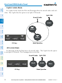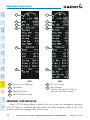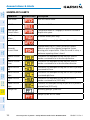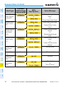
1
Cirrus SR20/SR22/SR22T Integrated Avionics System Cockpit Reference Guide FLIGHT INSTRUMENTS EIS NAV/COM/TRANSPONDER/AUDIO PANEL AUTOMATIC FLIGHT CONTROL SYSTEM GPS NAVIGATION FLIGHT PLANNING PROCEDURES HAZARD AVOIDANCE ADDITIONAL FEATURES ABNORMAL OPERATION ANNUNCIATIONS & ALERTS APPENDIX INDEX Copyright © 2008-2014 Garmin Ltd. or its subsidiaries. All rights reserved. This manual reflects the operation of System Software 0764.20 or later for the Cirrus Perspective™ Integrated Avionics System. Some differences in operation may be observed when comparing the information in this manual to earlier or later software versions. Always refer to the approved Airplane Flight Manual for a description of systems, limitations and procedures. For a complete list of Garmin manuals with corresponding part numbers and system software versions, refer to www.garmin.com. Garmin International, Inc., 1200 East 151st Street, Olathe, Kansas 66062, U.S.A. Tel: 913/397.8200Fax: 913/397.8282 Garmin AT, Inc., 2345 Turner Road SE, Salem, OR 97302, U.S.A. Tel: 503/391.3411Fax 503/364.2138 Garmin (Europe) Ltd, Liberty House, Bulls Copse Road, Hounsdown Business Park, Southampton, SO40 9RB, U.K. Tel: 44/0870.8501241 Fax: 44/0870.8501251 Garmin Corporation, No. 68, Jangshu 2nd Road, Shijr, Taipei County, Taiwan Tel: 886/02.2642.9199 Fax: 886/02.2642.9099 For after-hours emergency, aircraft on ground (AOG) technical support for Garmin panel mount and integrated avionics systems, please contact Garmin’s AOG Hotline at 913.397.0836. Web Site Address: www.garmin.com Except as expressly provided herein, no part of this manual may be reproduced, copied, transmitted, disseminated, downloaded or stored in any storage medium, for any purpose without the express written permission of Garmin. Garmin hereby grants permission to download a single copy of this manual and of any revision to this manual onto a hard drive or other electronic storage medium to be viewed for personal use, provided that such electronic or printed copy of this manual or revision must contain the complete text of this copyright notice and provided further that any unauthorized commercial distribution of this manual or any revision hereto is strictly prohibited. Garmin® , FliteCharts® and SafeTaxi® are registered trademarks of Garmin Ltd. or its subsidiaries. Garmin ESP™,ESP™,and Connext™ are trademarks of Garmin Ltd. or its subsidiaries. These trademarks may not be used without the express permission of Garmin. NavData® is a registered trademark of Jeppesen, Inc. Stormscope® is a registered trademark of L-3 Communications. SiriusXM Weather and SiriusXM Satellite Radio are provided by SiriusXM Satellite Radio, Inc. AOPA Membership Publications, Inc. and its related organizations (hereinafter collectively “AOPA”) expressly disclaim all warranties, with respect to the AOPA information included in this data, express or implied, including, but not limited to, the implied warranties of merchantability and fitness for a particular purpose. The information is provided “as is” and AOPA does not warrant or make any representations regarding its accuracy, reliability, or otherwise. Under no circumstances including negligence, shall AOPA be liable for any incidental, special or consequential damages that result from the use or inability to use the software or related documentation, even if AOPA or an AOPA authorized representative has been advised of the possibility of such damages. User agrees not to sue AOPA and, to the maximum extent allowed by law, to release and hold harmless AOPA from any causes of action, claims or losses related to any actual or alleged inaccuracies in the information. Some jurisdictions do not allow the limitation or exclusion of implied warranties or liability for incidental or consequential damages so the above limitations or exclusions may not apply to you. AC-U-KWIK and its related organizations (hereafter collectively “AC-U-KWIK Organizations”) expressly disclaim all warranties with respect to the AC-U-KWIK information included in this data, express or implied, including, but not limited to, the implied warranties of merchantability and fitness for a particular purpose. The information is provided “as is” and AC-U-KWIK Organizations do not warrant or make any representations regarding its accuracy, reliability, or otherwise. Licensee agrees not to sue AC-U-KWIK Organizations and, to the maximum extent allowed by law, to release and hold harmless AC-U-KWIK Organizations from any cause of action, claims or losses related to any actual or alleged inaccuracies in the information arising out of Garmin’s use of the information in the data sets. Some jurisdictions do not allow the limitation or exclusion of implied warranties or liability for incidental or consequential damages so the above limitations or exclusions may not apply to licensee. January, 2014 190-00821-10 Rev. A Printed in the U.S.A. Warnings, Cautions & Notes WARNING: Navigation and terrain separation must NOT be predicated upon the use of the terrain avoidance feature. The terrain avoidance feature is NOT intended to be used as a primary reference for terrain avoidance and does not relieve the pilot from the responsibility of being aware of surroundings during flight. The terrain avoidance feature is only to be used as an aid for terrain avoidance. Terrain data is obtained from third party sources. Garmin is not able to independently verify the accuracy of the terrain data. WARNING: The displayed minimum safe altitudes (MSAs) are only advisory in nature and should not be relied upon as the sole source of obstacle and terrain avoidance information. Always refer to current aeronautical charts for appropriate minimum clearance altitudes. WARNING: The altitude calculated by the system’s GPS receivers is geometric height above Mean Sea Level and could vary significantly from the altitude displayed by pressure altimeters, such as the GDC 74 Air Data Computer, or other altimeters in aircraft. GPS altitude should never be used for vertical navigation. Always use pressure altitude displayed by the PFD or other pressure altimeters in aircraft. WARNING: Do not use outdated database information. Databases used in the system must be updated regularly in order to ensure that the information remains current. Pilots using any outdated database do so entirely at their own risk. WARNING: Do not use basemap (land and water data) information for primary navigation. Basemap data is intended only to supplement other approved navigation data sources and should be considered as an aid to enhance situational awareness. WARNING: Do not rely solely upon the display of traffic information for collision avoidance maneuvering. The traffic display does not provide collision avoidance resolution advisories and does not under any circumstances or conditions relieve the pilot’s responsibility to see and avoid other aircraft. WARNING: Do not rely solely upon the display of traffic information to accurately depict all of the traffic within range of the aircraft. Due to lack of equipment, poor signal reception, and/or inaccurate information from aircraft or ground stations, traffic may be present that is not represented on the display. 190-00821-10 Rev. A Cirrus Perspective™ by Garmin – Cockpit Reference Guide for the SR20/SR22/SR22T Warnings, Cautions & Notes WARNING: Do not rely on information from a lightning detection system display as the sole basis for hazardous weather avoidance. Range limitations and interference may cause the system to display inaccurate or incomplete information. Refer to documentation from the lightning detection system manufacturer for detailed information about the system. WARNING: Do not use data link weather information for maneuvering in, near, or around areas of hazardous weather. Information contained within data link weather products may not accurately depict current weather conditions. WARNING: Do not use the indicated data link weather product age to determine the age of the weather information shown by the data link weather product. Due to time delays inherent in gathering and processing weather data for data link transmission, the weather information shown by the data link weather product may be significantly older than the indicated weather product age. WARNING: For safety reasons, system operational procedures must be learned on the ground. WARNING: The Garmin system, as installed in this aircraft, has a very high degree of functional integrity. However, the pilot must recognize that providing monitoring and/or self-test capability for all conceivable system failures is not practical. WARNING: The United States government operates the Global Positioning System and is solely responsible for its accuracy and maintenance. The GPS system is subject to changes which could affect the accuracy and performance of all GPS equipment. Portions of the Garmin system use GPS as a precision electronic NAVigation AID (NAVAID). Therefore, as with all NAVAIDs, information presented by the system can be misused or misinterpreted and, therefore, become unsafe. WARNING: To reduce the risk of unsafe operation, carefully review and understand all aspects of the system, Pilot’s Guide documentation and the Pilot’s Operating Handbook (POH). Thoroughly practice basic operation prior to actual use. During flight operations, carefully compare indications from the system to all available navigation sources, including the information from other NAVAIDs, visual sightings, charts, etc. For safety purposes, always resolve any discrepancies before continuing navigation. Cirrus Perspective™ by Garmin – Cockpit Reference Guide for the SR20/SR22/SR22T 190-00821-10 Rev. A Warnings, Cautions & Notes WARNING: Lamp(s) inside this product may contain mercury (HG) and must be recycled or disposed of according to local, state, or federal laws. For more information, refer to our website at www.garmin.com/aboutGarmin/ environment/disposal.jsp. WARNING: Because of variation in the earth’s magnetic field, operating the system within the following areas could result in loss of reliable attitude and heading indications. North of 72° North latitude at all longitudes; South of 70° South latitude at all longitudes; North of 65° North latitude between longitude 75° W and 120° W. (Northern Canada); North of 70° North latitude between longitude 70° W and 128° W. (Northern Canada); North of 70° North latitude between longitude 85° E and 114° E. (Northern Russia); South of 55° South latitude between longitude 120° E and 165° E. (Region south of Australia and New Zealand) WARNING: Do not use GPS to navigate to any active waypoint identified as a ‘NON WGS84 WPT’ by a system message. ‘NON WGS84 WPT’ waypoints are derived from an unknown map reference datum that may be incompatible with the map reference datum used by GPS (known as WGS84) and may be positioned in error as displayed. CAUTION: The PFD and MFD displays use a lens coated with a special anti-reflective coating that is very sensitive to skin oils, waxes, and abrasive cleaners. CLEANERS CONTAINING AMMONIA WILL HARM THE ANTIREFLECTIVE COATING. It is very important to clean the lens using a clean, lint-free cloth and an eyeglass lens cleaner that is specified as safe for antireflective coatings. CAUTION: The system does not contain any user-serviceable parts. Repairs should only be made by an authorized Garmin service center. Unauthorized repairs or modifications could void both the warranty and the pilot’s authority to operate this device under FAA/FCC regulations. NOTE: When using the lightning detection system, there are several atmospheric phenomena in addition to nearby thunderstorms that can cause isolated discharge points in the strike display mode. However, clusters of two or more discharge points in the strike display mode do indicate thunderstorm activity if these points reappear after the screen has been cleared. 190-00821-10 Rev. A Cirrus Perspective™ by Garmin – Cockpit Reference Guide for the SR20/SR22/SR22T Warnings, Cautions & Notes NOTE: Do not rely solely upon data link services to provide Temporary Flight Restriction (TFR) information. Always confirm TFR information through official sources such as Flight Service Stations or Air Traffic Control. NOTE: All visual depictions contained within this document, including screen images of the panel and displays, are subject to change and may not reflect the most current system and aviation databases. Depictions of equipment may differ slightly from the actual equipment. NOTE: This device complies with part 15 of the FCC Rules. Operation is subject to the following two conditions: (1) this device may not cause harmful interference, and (2) this device must accept any interference received, including interference that may cause undesired operation. NOTE: Interference from GPS repeaters operating inside nearby hangars can cause an intermittent loss of attitude and heading displays while the aircraft is on the ground. Moving the aircraft more than 100 yards away from the source of the interference should alleviate the condition. NOTE: Use of polarized eyewear may cause the flight displays to appear dim or blank. NOTE: This product, its packaging, and its components contain chemicals known to the State of California to cause cancer, birth defects, or reproductive harm. This notice is being provided in accordance with California’s Proposition 65. If you have any questions or would like additional information, please refer to our web site at www.garmin.com/prop65. NOTE: The purpose of this Cockpit Reference Guide is to provide the pilot a resource with which to find operating instructions on the major features of the Perspective™ system more easily. It is not intended to be a comprehensive operating guide. Complete operating procedures for the system are found in the Perspective™ Pilot’s Guide for this aircraft. Cirrus Perspective™ by Garmin – Cockpit Reference Guide for the SR20/SR22/SR22T 190-00821-10 Rev. A Record of Revisions Part Number 190-00821-00 Rev A Rev B Rev C 190-00821-01 190-00821-02 190-00821-03 190-00821-04 190-00821-05 190-00821-06 190-00821-10 Rev. A Change Summary Initial release Made clerical changes Made clerical changes to pages 8 and 91 Added Enhanced Vision System Added changes in page navigation Added new procedures for creating user waypoints Added importing and exporting flight plans Updated Warning Alerts, Caution Alerts, and Advisory Annunciations Added new XM Weather product symbols Added other GDU 9.10 parameters Added SR20 engine display operation Added FIKI Anti-icing system GDU 9.12 Added AOPA Airport Directory Added dual navigation database capability Added database synchronization Added GDU 10.00 parameters Added the SR22 Turbo Added GDU 11.00 parameters Added GTS 800 Traffic Advisory System Changed SR22 Turbo to SR22T Added Profile View Updated Active Flight Plan modification procedures to include the Quick Select Box and Insertion Point Indicator Updated XM Weather product status display Added Electronic Stability & Protection Added Underspeed Protection Added Hypoxia Detection System Added other GDU 11.11 parameters Cirrus Perspective™ by Garmin – Cockpit Reference Guide for the SR20/SR22/SR22T RR-1 Record of Revisions Part Number 190-00821-07 190-00821-08 190-00821-09 190-00821-10 Change Summary Added GMA 350 Audio Panel Added Iridium Satellite Telephone Added GFDS Worldwide Weather Added WX LGND, LEGEND, and METAR softkeys Updated system messages Added other GDU 12.01 parameters ® Added L-3 SKYWATCH Traffic Added GDU 12.10 parameters Updated system messages Added Pilot Profiles Import/Export Added Pilot Profile Import/Export messages Updated XM volume and mute procedures Replaced BRG field with ETE on the PFD GDU 12.11 Added GDL 59 Added Fuel Quantity Indicators to EIS Updated system messages GDU 14.01 Updated Warnings, Cautions, and Notes section Changed references to SVS (Synthetic Vision System) to SVT (Synthetic Vision Technology) Removed references to GFC 700 and replaced with Garmin AFCS Changed references to GFDS and World Wide Weather to Garmin Connext™ and Connext Weather Removed System Data Logging feature Added Position Reporting feature Added Scheduler feature Added Present Position indication in the Timer/Reference Window Added display of Flight Path Marker independent of SVT Added Temperature Compensated Altitude feature Added User Defined Holding Patterns Revision Date of Revision Affected Pages A January, 2014 All RR-2 Description Production Release Cirrus Perspective™ by Garmin – Cockpit Reference Guide for the SR20/SR22/SR22T 190-00821-10 Rev. A Table of Contents FLIGHT INSTRUMENTS................................................................................................................. 1 Selecting the Altimeter Barometric Pressure Setting....................................................... 1 Selecting Standard Barometric Pressure.............................................................................. 1 Change Altimeter Barometric Pressure Setting Units....................................................... 1 Change Navigation Sources.................................................................................................... 1 Enable/Disable OBS Mode While Navigating with GPS..................................................... 1 Generic Timer.............................................................................................................................. 2 Present Position Lat/Lon.......................................................................................................... 2 Configure V-speed Bugs............................................................................................................ 2 Set Barometric Minimum Descent Altitude......................................................................... 3 Displaying Wind Data............................................................................................................... 3 ENGINE INDICATION SYSTEM.................................................................................................. 5 Engine Page................................................................................................................................ 7 NAV/COM/TRANSPONDER/AUDIO PANEL........................................................................ 15 DME Tuning............................................................................................................................... 15 Enter a Transponder Code..................................................................................................... 15 Selecting a COM Radio........................................................................................................... 15 Selecting a NAV Radio............................................................................................................ 16 NAV/COM Tuning...................................................................................................................... 16 Split COM................................................................................................................................... 16 Intercom System (ICS) Isolation........................................................................................... 17 Telephone/Entertainment Audio.......................................................................................... 22 3D Audio (GMA 350 only)....................................................................................................... 24 Digital Clearance Player......................................................................................................... 24 AUTOMATIC FLIGHT CONTROL SYSTEM........................................................................... 25 Garmin AFCS............................................................................................................................. 25 S-TEC Fifty Five X Autopilot (Optional)............................................................................... 28 GPS NAVIGATION......................................................................................................................... 29 Direct-to Navigation............................................................................................................... 29 Activate a Stored Flight Plan................................................................................................ 30 Activate a Flight Plan Leg...................................................................................................... 30 Stop Navigating a Flight Plan............................................................................................... 31 Vertical Navigation (VNAV)................................................................................................... 31 FLIGHT PLANNING....................................................................................................................... 35 Trip Planning............................................................................................................................. 35 Create a User Waypoint Defined by Latitude & Longitude............................................ 37 Create a User Waypoint Defined by Radials from Other Waypoints............................ 37 Create a User Waypoint Defined by a Radial & Distance from Another Waypoint... 39 Create a User Waypoint Using the Map Pointer............................................................... 41 190-00821-10 Rev. A Cirrus Perspective™ by Garmin – Cockpit Reference Guide for the SR20/SR22/SR22T i Table of Contents Delete a User Waypoint.......................................................................................................... 41 Create a Flight Plan................................................................................................................. 42 Import a Flight Plan from an SD Card................................................................................. 43 Insert a Waypoint in the Active Flight Plan....................................................................... 44 Enter an Airway in a Flight Plan........................................................................................... 45 Creating a User-Defined Hold at an Active Flight Plan Waypoint................................. 46 Creating a User-Defined Hold at the Aircraft Present Position..................................... 47 Removing a User-Defined Hold (Created at the Aircraft P.POS)................................... 47 Removing a User-Defined Hold (Created at an Active Waypoint)................................ 48 Invert An Active Flight Plan................................................................................................... 48 Remove a Departure, Arrival, Approach, or Airway from a Flight Plan...................... 48 Store a Flight Plan................................................................................................................... 49 Edit a Stored Flight Plan........................................................................................................ 49 Delete a Waypoint from the Flight Plan............................................................................. 49 Invert and Activate a Stored Flight Plan............................................................................ 50 Copy a Flight Plan.................................................................................................................... 51 Delete a Flight Plan................................................................................................................. 51 Graphical Flight Plan Creation (Active Flight Plan Only)................................................ 51 Export a Flight Plan to an SD Card...................................................................................... 52 PROCEDURES.................................................................................................................................. 53 Load and Activate a Departure Procedure........................................................................ 53 Activate A Departure Leg...................................................................................................... 53 Load An Arrival Procedure..................................................................................................... 54 Activate An Arrival Leg.......................................................................................................... 54 Load and/or Activate an Approach Procedure.................................................................. 55 Activate An Approach in the Active Flight Plan................................................................ 56 Activate a Vector to Final Approach Fix............................................................................. 56 Activate A Missed Approach in the Active Flight Plan.................................................... 56 Temperature Compensated Altitude................................................................................... 57 HAZARD AVOIDANCE................................................................................................................. 59 Customizing the Hazard Displays on the Navigation Map............................................. 59 Stormscope® (Optional)......................................................................................................... 59 SiriusXM Weather (Optional)................................................................................................ 61 Connext Weather (Optional)................................................................................................. 63 Traffic Advisory Systems........................................................................................................ 75 Terrain And Obstacle Proximity............................................................................................ 78 Terrain-SVT (Optional)............................................................................................................ 79 Terrain Awareness & Warning System (TAWS-B) Display (Optional)............................ 81 ii Cirrus Perspective™ by Garmin – Cockpit Reference Guide for the SR20/SR22/SR22T 190-00821-10 Rev. A Table of Contents ADDITIONAL FEATURES............................................................................................................ 85 Synthetic Vision (Optional).................................................................................................... 85 Enhanced Vision System (Optional)..................................................................................... 86 Terminal Procedure Charts.................................................................................................... 87 Airport Directory..................................................................................................................... 89 SiriusXM Radio Entertainment (Optional)......................................................................... 89 Satellite Telephone & SMS Messaging Service (Optional)............................................. 91 Wi-Fi Connections (Optional).............................................................................................. 102 Scheduler................................................................................................................................. 104 Electronic Checklists (Optional).......................................................................................... 106 Hypoxia Recognition with Automatic Descent Mode (Optional)................................ 108 Electronic Stability and Protection (ESP™) (Optional)................................................... 109 Pilot Profiles........................................................................................................................... 111 Position Reporting................................................................................................................ 113 ABNORMAL OPERATION........................................................................................................ 115 Reversionary Mode............................................................................................................... 115 Abnormal COM Operation................................................................................................... 116 Hazard Displays with Loss of GPS Position...................................................................... 117 Unusual Attitudes.................................................................................................................. 117 Dead Reckoning..................................................................................................................... 118 ANNUNCIATIONS & ALERTS.................................................................................................. 121 Perspective™ System Annunciations................................................................................. 121 WARNING Alerts..................................................................................................................... 123 CAUTION Alerts....................................................................................................................... 124 Advisory Annunciations....................................................................................................... 126 Comparator Annunciations.................................................................................................. 126 Reversionary Sensor Annunciations.................................................................................. 127 Message Advisory Alerts...................................................................................................... 127 Garmin AFCS Alerts............................................................................................................... 128 Garmin AFCS Speed Condition/Stall Alert........................................................................ 129 Terrain-SVT Alerts.................................................................................................................. 129 Terrain-SVT System Status Annunciations....................................................................... 130 TAWS-B Alerts......................................................................................................................... 131 TAWS-B System Status Annunciations.............................................................................. 133 Voice Alerts............................................................................................................................. 133 CO Guardian Messages......................................................................................................... 134 MFD & PFD Message Advisories......................................................................................... 135 Database Message Advisories............................................................................................ 136 GMA 347 & GMA 350 Message Advisories....................................................................... 139 GIA 63W Message Advisories.............................................................................................. 140 GEA 71 Message Advisories................................................................................................. 143 190-00821-10 Rev. A Cirrus Perspective™ by Garmin – Cockpit Reference Guide for the SR20/SR22/SR22T iii Table of Contents GTX 32 & GTX 33 Message Advisories............................................................................... 143 GRS 77 Message Advisories................................................................................................. 144 GMU 44 Message Advisories............................................................................................... 145 GDC 74A Message Advisories.............................................................................................. 146 GSR 56 Message Advisories................................................................................................. 146 GDL 69/69A Message Advisories........................................................................................ 147 GDL 59 Message Advisories................................................................................................. 147 GCU 478 Message Advisories.............................................................................................. 148 GDL 90 Message Advisories................................................................................................. 148 GTS 800 Message Advisories............................................................................................... 148 GMC 705 Message Advisories............................................................................................. 149 Miscellaneous Message Advisories.................................................................................... 149 Flight Plan Import/Export Messages................................................................................. 153 Pilot Profile Import/Export Messages............................................................................... 155 APPENDIX...................................................................................................................................... 157 PFD Softkey Map................................................................................................................... 157 MFD Softkey Map.................................................................................................................. 163 Loading Updated Databases............................................................................................... 166 INDEX..........................................................................................................................................Index-1 iv Cirrus Perspective™ by Garmin – Cockpit Reference Guide for the SR20/SR22/SR22T 190-00821-10 Rev. A Flight Instruments Flight Instruments FLIGHT INSTRUMENTS SELECTING THE ALTIMETER BAROMETRIC PRESSURE SETTING EIS Turn the BARO Knob to select the desired setting. Nav/Com/ XPDR/Audio SELECTING STANDARD BAROMETRIC PRESSURE Press the BARO Knob. AFCS CHANGE ALTIMETER BAROMETRIC PRESSURE SETTING UNITS 1) Press the PFD Softkey to display the second-level softkeys. GPS Nav 2) Press the ALT UNIT Softkey. Flight Planning 3) Press the IN Softkey to display the barometric pressure setting in inches of mercury (in Hg). Or: Procedures Press the HPA Softkey to display the barometric pressure setting in hectopascals. 4) Press the BACK Softkey to return to the top-level softkeys. Abnormal Operation 2) Press the CDI Softkey again to change from VOR1 or LOC1 to VOR2 or LOC2. This places the light blue tuning box over the NAV2 standby frequency. Annun/ Alerts 3) Press the CDI Softkey a third time to return to GPS. ENABLE/DISABLE OBS MODE WHILE NAVIGATING WITH GPS Appendix 1) Press the OBS Softkey to select OBS Mode. Index 2) Turn a CRS Knob to select the desired course to/from the waypoint. Press the CRS Knob to synchronize the Selected Course with the bearing to the next waypoint. 3) Press the OBS Softkey again to disable OBS Mode. 190-00821-10 Rev. A Cirrus Perspective™ by Garmin – Cockpit Reference Guide for the SR20/SR22/SR22T Additional Features 1) Press the CDI Softkey to change from GPS to VOR1 or LOC1. This places the light blue tuning box over the NAV1 standby frequency in the upper left corner of the PFD. Hazard Avoidance CHANGE NAVIGATION SOURCES 1 GENERIC TIMER 1) Press the TMR/REF Softkey, then turn the large FMS Knob to select the time field (hh/mm/ss). Turn the FMS Knobs to set the desired time, then press the ENT Key. The UP/DOWN field is now highlighted. EIS Flight Instruments Flight Instruments Nav/Com/ XPDR/Audio 2) Turn the small FMS Knob to display the UP/DOWN window. Turn the FMS Knob to select ‘UP’ or ‘DOWN’, then press the ENT Key. ‘START?’ is now highlighted. PRESENT POSITION LAT/LON 1) Press the TMR/REF Softkey. 2) Turn the large FMS Knob to scroll to the bottom of the window. The latitude and longitude representing the current aircraft position is displayed in degrees and minutes. CONFIGURE V-SPEED BUGS Hazard Avoidance Procedures Flight Planning GPS Nav AFCS 3) Press the ENT Key to START, STOP, or RESET the timer (if the timer is counting DOWN, it will start counting UP after reaching zero). Press the CLR Key or the TMR/REF Softkey to remove the window. NOTE: V-speed values cannot be adjusted in all models. Abnormal Operation Additional Features 1) Press the TMR/REF Softkey. 2) Turn the large FMS Knob to highlight the desired V-speed. 3) Use the small FMS Knob to change the V-speed in 1-kt increments. Vx Annun/ Alerts may be adjusted up to 89 knots and Vy may be adjusted down to 89 knots. Vglide and Vrotate cannot be adjusted. When a speed has been changed from a default value, an asterisk appears next to the value. 4) Press the ENT Key or turn the large FMS Knob to highlight the ON/OFF field Appendix 5) Turn the small FMS Knob clockwise to ON or counterclockwise to OFF. Index 6) To remove the window, press the CLR Key or the TMR/REF Softkey. 2 Cirrus Perspective™ by Garmin – Cockpit Reference Guide for the SR20/SR22/SR22T 190-00821-10 Rev. A Flight Instruments Flight Instruments SET BAROMETRIC MINIMUM DESCENT ALTITUDE 1) Press the TMR/REF Softkey. EIS 2) Turn the large FMS Knob to highlight the OFF/BARO field to the right of ‘MINIMUMS’. Nav/Com/ XPDR/Audio 3) Turn the small FMS Knob clockwise to BARO. 4) Press the ENT Key. 5) Use the small FMS Knob to enter the desired altitude. AFCS 6) Press the ENT Key. 7) To remove the window, press the CLR Key or the TMR/REF Softkey. GPS Nav DISPLAYING WIND DATA 1) Press the PFD Softkey. Flight Planning 2) Press the WIND Softkey to display wind data below the Selected Heading. Procedures 3) Press the OPTN 1 or OPTN 2 Softkey to change how wind data is displayed. 4) To remove the Wind Data Window, press the OFF Softkey. Hazard Avoidance Additional Features Abnormal Operation Annun/ Alerts Appendix Index 190-00821-10 Rev. A Cirrus Perspective™ by Garmin – Cockpit Reference Guide for the SR20/SR22/SR22T 3 Index Appendix Annun/ Alerts Abnormal Operation Additional Features Hazard Avoidance Procedures Flight Planning GPS Nav AFCS Nav/Com/ XPDR/Audio EIS Flight Instruments Flight Instruments Blank Page 4 Cirrus Perspective™ by Garmin – Cockpit Reference Guide for the SR20/SR22/SR22T 190-00821-10 Rev. A EIS 1 2 2 3 3 4 4 5 5 EIS 1 Flight Instruments ENGINE INDICATION SYSTEM Nav/Com/ XPDR/Audio AFCS 9 9 10 10 11 11 Abnormal Operation SR20 Additional Features 8 Hazard Avoidance 8 Procedures 7 Flight Planning 7 SR22 (Naturally Aspirated) Gallons Used 2 Tachometer 6 Oil Temperature 3 Manifold Pressure 7 Oil Pressure 4 Fuel Quantity & Fuel Flow 8 Ammeter 9 Voltmeter 10 Cylinder Head Temperature 11 Exhaust Gas Temperature Cirrus Perspective™ by Garmin – Cockpit Reference Guide for the SR20/SR22/SR22T Index 5 Appendix Percent Power Annun/ Alerts 1 190-00821-10 Rev. A GPS Nav 6 6 5 Nav/Com/ XPDR/Audio EIS Flight Instruments EIS 1 1 2 2 3 3 4 4 Target Fuel Flow 5 5 6 6 7 7 8 8 9 9 10 10 Additional Features Hazard Avoidance Procedures Flight Planning GPS Nav AFCS Target Fuel Flow 12 11 Annun/ Alerts Abnormal Operation SR22T SR22TN 1 Percent Power 5 Gallons Used 2 Tachometer 6 Oil Temperature 3 Manifold Pressure 7 Oil Pressure 4 Fuel Quantity & Fuel Flow 8 Ammeter 9 Voltmeter 10 Cylinder Head Temperature 11 Exhaust Gas Temperature 12 Left and Right Turbine Inlet Temperature Index Appendix 12 11 6 Cirrus Perspective™ by Garmin – Cockpit Reference Guide for the SR20/SR22/SR22T 190-00821-10 Rev. A EIS 1 2 3 4 EIS Pressing the ENGINE Softkey accesses the EIS - Engine Page, which displays all engine, fuel, fuel calculation, electrical, and air data information. Pressing the FUEL Softkey accesses the second-level softkeys. Flight Instruments ENGINE PAGE 5 Nav/Com/ XPDR/Audio AFCS GPS Nav 6 12 Flight Planning 7 Procedures 8 9 1 2 3 4 Hazard Avoidance SR20 5 Additional Features Abnormal Operation Annun/ Alerts 6 12 Appendix 7 8 11 Index 9 SR22 190-00821-10 Rev. A Cirrus Perspective™ by Garmin – Cockpit Reference Guide for the SR20/SR22/SR22T 7 EIS 2 Target Fuel 3 Flow Indicator 4 5 Nav/Com/ XPDR/Audio EIS Flight Instruments 1 6 AFCS 12 GPS Nav 7 8 11 9 Flight Planning 10 Procedures SR22T 2 3 Target Fuel Flow Indicator 4 5 Abnormal Operation Additional Features Hazard Avoidance 1 6 Annun/ Alerts 12 7 8 Appendix 11 9 10 Index SR22TN 8 Cirrus Perspective™ by Garmin – Cockpit Reference Guide for the SR20/SR22/SR22T 190-00821-10 Rev. A EIS 7 Fuel Calculation Group 2 Tachometer 8 Fuel Quantity Indicator 3 Manifold Pressure 9 Air Data 4 Fuel Flow 10 Oxygen Pressure 5 Oil Temperature 11 6 Electrical Group EIS Percent Power Flight Instruments 1 Nav/Com/ XPDR/Audio Anti-Ice Fluid Quantity Indicator (TKS NH and TKS FIKI) 12 Engine Temperature Group NOTE: Fuel calculations do not use the aircraft fuel quantity indicators and are calculated from the last time the fuel was reset. Additional Features Abnormal Operation Calculated Range Annun/ Alerts Calculated Economy Hazard Avoidance Fuel Remaining Calculated Time Remaining Procedures Calculated Fuel Used Flight Planning Adjusting the fuel totalizer quantity: 1) Press the ENGINE Softkey to display the Engine Page. 2) Press the FUEL Softkey to access the Initial Usable Fuel Page. 3) Turn the FMS Knob (small knob adjusts in 1 gallon increments and large knob in 10 gallon increments) to increase or decrease the initial usable fuel displayed. GPS Nav AFCS Fuel Calculations Appendix Fuel Calculations Group Index 190-00821-10 Rev. A Cirrus Perspective™ by Garmin – Cockpit Reference Guide for the SR20/SR22/SR22T 9 GPS Nav AFCS Nav/Com/ XPDR/Audio EIS Flight Instruments EIS Appendix Annun/ Alerts Abnormal Operation Additional Features Hazard Avoidance Procedures Flight Planning Full Fuel (SR20) Initial Usable Fuel Page Index Fuel to TABS (SR22) Initial Usable Fuel Page 10 Cirrus Perspective™ by Garmin – Cockpit Reference Guide for the SR20/SR22/SR22T 190-00821-10 Rev. A EIS Flight Instruments EIS Nav/Com/ XPDR/Audio AFCS GPS Nav Flight Planning Full Fuel (SR22) Initial Usable Fuel Page Procedures Leaning Assist Mode NOTE: The pilot should follow the engine manufacturer’s recommended leaning procedures in the Pilot’s Operating Handbook (POH). Additional Features Accessing Leaning Assist Mode: 1) Press the ENGINE Softkey to display the Engine Page. 2) Press the ASSIST Softkey to identify peaks. Hazard Avoidance Abnormal Operation Annun/ Alerts Appendix When the ASSIST Softkey is pressed, the system initially highlights the number and places a light blue box around the EGT readout of the cylinder with the hottest EGT. The ∆ Peak temperature is the difference between the peak temperature and the present temperature for the peaked cylinder. When the first peak is detected, “1st” is annunciated below that cylinder’s EGT bar and the temperature is enclosed in a light blue box. Index 190-00821-10 Rev. A Cirrus Perspective™ by Garmin – Cockpit Reference Guide for the SR20/SR22/SR22T 11 The system continues to detect peak EGTs for each cylinder lean of peak as the fuel flow is decreased, and the peak of each cylinder’s EGT is indicated by a light blue marker on the graph. Once all cylinders are lean of peak, the last cylinder to peak is denoted by the “Last” annunciation below its bar on the graph. EIS Flight Instruments EIS AFCS Nav/Com/ XPDR/Audio Light Blue Box Represents Peak Flight Planning GPS Nav Temperature Deviation from Peak TKS FIKI Anti-ice System In the default tank selection mode (AUTO), the system assures the fluid level in the two tanks is kept relatively even by periodically closing the tank with the lowest level. The system uses the TKS fluid tank quantity to control the tank shut-off valves. When the system is on and operating in AUTO mode, the shut-off valves close under the following conditions: • The left and right tank level imbalance is greater than 0.25 gallons (low tank will be closed until level balance is within 0.15 gallons) • The fluid quantity is empty (indicated from the fluid level sensor and level switch) • The fluid quantity is unreliable (a miscompare between the level sensor and level switch or an out of range level sensor value) Index Appendix Annun/ Alerts Abnormal Operation Additional Features Hazard Avoidance Procedures Leaning Assist Mode 12 Cirrus Perspective™ by Garmin – Cockpit Reference Guide for the SR20/SR22/SR22T 190-00821-10 Rev. A EIS EIS • LEFT Softkey – opens left tank valve and closes right tank valve • AUTO Softkey – returns to AUTO tank mode • RIGHT Softkey – opens right tank valve and closes left tank valve Flight Instruments Manual tank mode allows the pilot to control either tank’s shut-off valve. Manual may be selected by pressing the ANTI-ICE Softkey to access the second-level softkeys LEFT, AUTO, and RIGHT. Nav/Com/ XPDR/Audio While operating in manual tank mode, only the selected/open tank’s quantity is used for the range and endurance calculations. AFCS GPS Nav Flight Planning Manual Tank Mode (Left tank selected) Comments System Off No modes selected Both pumps operate on a timed, repeating cycle – 30 seconds ON and 90 seconds OFF Provides 50% flow rate for light/ moderate icing A single primary pump (#1) operates continuously Provides 100% flow rate for moderate icing MAX (momentary) Both primary pumps operate continuously for 120 seconds Provides 200% flow rate for severe icing or to expedite the removal of previous ice buildup PUMP BKUP A single primary pump (#2) operates continuously This mode is used in the event of a timer box failure or when BKUP mode is selected. Pump #2 provides 100% flow rate, bypassing the timer box NORMAL Abnormal Operation HIGH Additional Features OFF System Operation Hazard Avoidance Operating Mode Annun/ Alerts Index Cirrus Perspective™ by Garmin – Cockpit Reference Guide for the SR20/SR22/SR22T Appendix Refer to the AFM for recommended pilot actions 190-00821-10 Rev. A Procedures The TKS FIKI system consists of various operating modes, which are presented on the Perspective™ system. A white box highlights the active mode. Descriptions of the various modes are listed in the following table: 13 Index Appendix Annun/ Alerts Abnormal Operation Additional Features Hazard Avoidance Procedures Flight Planning GPS Nav AFCS Nav/Com/ XPDR/Audio EIS Flight Instruments EIS Blank Page 14 Cirrus Perspective™ by Garmin – Cockpit Reference Guide for the SR20/SR22/SR22T 190-00821-10 Rev. A Nav/Com/XPDR/Audio Panel Flight Instruments NAV/COM/TRANSPONDER/AUDIO PANEL DME TUNING EIS 1) Press the DME Softkey. Nav/Com/ XPDR/Audio 2) Turn the large FMS Knob to select the DME source field. 3) Turn the small FMS Knob to select the desired Nav radio. 4) Press the ENT Key to complete the selection. AFCS ENTER A TRANSPONDER CODE Or: Abnormal Operation 2) Enter a code with the Numeric Keypad or FMS Knob on the PFD/MFD Control Unit. Five seconds after the fourth digit has been entered, the transponder code becomes active. SELECTING A COM RADIO Annun/ Alerts Transmit/Receive Appendix Press the COM1 MIC (MIC1 for GMA 350), or COM2 MIC (MIC2 for GMA 350) on the audio panel. Receive Only Press the COM1, or COM2, on the audio panel. 190-00821-10 Rev. A Cirrus Perspective™ by Garmin – Cockpit Reference Guide for the SR20/SR22/SR22T Index Additional Features 1) Press the XPDR Key on the PFD/MFD Control Unit to select the transponder function. Hazard Avoidance Procedures 3) Press the digit softkeys to enter the code in the Code Field or enter a code with the Numeric Keypad. When entering the code, the next key in sequence must be pressed within 10 seconds, or the entry is cancelled and restored to the previous code. Five seconds after the fourth digit has been entered, the transponder code becomes active. Flight Planning 2) Press the CODE Softkey to display the transponder code selection softkeys, for digit entry. GPS Nav 1) Press the XPDR Softkey to display the transponder mode selection softkeys. 15 SELECTING A NAV RADIO 1) To begin navigating using a navigation radio, press the CDI Softkey on the PFD to select VOR1/LOC1 (NAV1) or VOR2/LOC2 (NAV2). 2) Press the NAV1, NAV2, DME (GMA 347 only), or ADF (GMA 347 only) Key on the audio panel to select or deselect the navigation radio audio source. All radio keys can be selected individually or together. On GMA 350 installs with optional DME and/or ADF to select audio press AUX key. NAV/COM TUNING 1) Turn the respective tuning knobs to enter the desired frequency into the standby frequency field. The large knob enters MHz and the small knob enters kHz. GPS Nav AFCS Nav/Com/ XPDR/Audio EIS Flight Instruments Nav/Com/XPDR/Audio Panel 2) Press the appropriate Frequency Transfer Key to place the frequency into the active frequency field. Flight Planning 1) Press the COM or NAV Key on the PFD/MFD Control Unit to select the desired COM or NAV frequency box. Procedures Hazard Avoidance Additional Features Abnormal Operation Annun/ Alerts Appendix Index Or: 2) Turn the FMS/XPDR COM/NAV Knob to tune the desired frequency (large knob for MHz; small knob for kHz). 3) Press the Frequency Transfer Key to transfer the frequency to the active field. SPLIT COM During Split COM operation, both the pilot and the copilot can transmit simultaneously over separate radios. GMA 347 The pilot can still monitor NAV1, NAV2, ADF, DME, and MKR Audio as selected, but the copilot is only able to monitor COM2. When Split COM operation is selected, COM1 is used by the pilot and COM2 is used by the copilot. The COM1 MIC Annunciator flashes when the pilot’s microphone PTT is pressed. The COM2 MIC Annunciator flashes when the copilot’s microphone PTT is pressed. Pressing the COM 1/2 Key selects Split COM operation. The COM 1/2 Annunciator is illuminated indicating Split COM operation. COM1 and COM2 frequencies are displayed in green indicating that both transceivers are active. Split COM operation is cancelled by pressing the COM 1/2 Key again, at which time the annunciator is extinguished. 16 Cirrus Perspective™ by Garmin – Cockpit Reference Guide for the SR20/SR22/SR22T 190-00821-10 Rev. A Nav/Com/XPDR/Audio Panel OFF ON Selected radios, aural alerts, pilot, passengers, music Selected radios, aural alerts, pilot, copilot Passengers, music Appendix ON Copilot Annun/ Alerts ON Copilot, passengers, music Abnormal Operation OFF Selected radios, aural alerts, pilot, copilot, passengers, music Additional Features ON Selected radios, aural alerts, pilot, copilot, passengers, music Copilot, passengers, music Passenger Hears Hazard Avoidance OFF Selected radios, aural alerts, pilot, copilot, passengers, music Selected radios, aural alerts, pilot Selected radios, aural alerts, pilot; passengers, music Selected radios, aural alerts, pilot, copilot Copilot Hears Procedures OFF Pilot Hears Flight Planning PILOT KEY COPLT KEY Annunciator Annunciator Cirrus Perspective™ by Garmin – Cockpit Reference Guide for the SR20/SR22/SR22T Index ICS Isolation Modes 190-00821-10 Rev. A GPS Nav Press the PILOT and/or COPLT Key on the audio panel to select those isolated from hearing the Nav/Com radios and music. AFCS GMA 347 Nav/Com/ XPDR/Audio INTERCOM SYSTEM (ICS) ISOLATION EIS Pressing both MIC Keys simultaneously initiates Split COM Mode (i.e., COM1/ COM2). The respective COM1/MIC1 or COM2/MIC2 annunciators are illuminated indicating Split COM operation. Split COM operation is cancelled by pressing one of the selected MIC Keys again. In Split COM mode, the pilot uses COM1 and the copilot uses COM2. Flight Instruments GMA 350 17 Nav/Com/XPDR/Audio Panel Flight Instruments GMA 350 EIS NOTE: In the default ICS configuration, only the pilot and copilot positions can hear aircraft alerts. All Intercom Mode In ‘All Intercom’ mode the Pilot, Copilot, and Passengers hear each other and hear the aircraft audio. Aircraft Audio Flight Planning GPS Nav AFCS Nav/Com/ XPDR/Audio NOTE: In the following modes the copilot position is configured as crew. Hazard Avoidance Procedures PILOT COPLT Additional Features PASS Mode Operation Index Appendix Annun/ Alerts Abnormal Operation ICS Keys 18 Cirrus Perspective™ by Garmin – Cockpit Reference Guide for the SR20/SR22/SR22T 190-00821-10 Rev. A Nav/Com/XPDR/Audio Panel In ‘Pilot Isolate’ mode the Pilot, Copilot, and Passengers hear the aircraft audio. The Copilot and Passengers also hear each other. EIS Aircraft Audio Flight Instruments Pilot Isolate Mode Nav/Com/ XPDR/Audio AFCS PILOT COPLT GPS Nav Mode Operation Procedures ICS Keys Flight Planning PASS In ‘Passenger/Crew Isolate’ mode the Pilot and Copilot hear the aircraft audio and each other. The Passengers hear each other. Additional Features Aircraft Audio COPLT Abnormal Operation PILOT Hazard Avoidance Passenger/Crew Isolate Mode PASS Annun/ Alerts Mode Operation Appendix ICS Keys Index 190-00821-10 Rev. A Cirrus Perspective™ by Garmin – Cockpit Reference Guide for the SR20/SR22/SR22T 19 Copilot Isolate Mode In ‘Copilot Isolate’ mode the Pilot and Passengers hear the aircraft audio and each other. The Copilot has the option to use Split-COM mode. Split-COM EIS Flight Instruments Nav/Com/XPDR/Audio Panel Nav/Com/ XPDR/Audio Aircraft Audio AFCS COPLT Flight Planning GPS Nav PILOT Procedures PASS Mode Operation All Isolate Mode In ‘All Isolate’ mode the Pilot hears the aircraft audio. The Copilot has the option to use Split-COM mode. The Passengers hear each other. Aircraft Audio Annun/ Alerts Abnormal Operation Additional Features Hazard Avoidance ICS Keys Appendix PILOT COPLT PASS Mode Operation Index ICS Keys Split-COM 20 Cirrus Perspective™ by Garmin – Cockpit Reference Guide for the SR20/SR22/SR22T 190-00821-10 Rev. A Nav/Com/XPDR/Audio Panel In ‘Pilot & Copilot Isolate’ mode the Pilot and Passengers hear the aircraft audio. The Copilot has the option to use Split-COM mode. PASS Nav/Com/ XPDR/Audio PILOT Split-COM EIS Aircraft Audio Flight Instruments Pilot & Copilot Isolate Mode COPLT AFCS ICS Keys Mode Operation GPS Nav Pilot & Passenger Isolate Mode Aircraft Audio Flight Planning In ‘Pilot & Passenger Isolate’ mode the Pilot and Copilot hear the aircraft audio. The Passengers hear each other. Procedures COPLT Additional Features ICS Keys PASS Hazard Avoidance PILOT Mode Operation In ‘Copilot & Passenger Isolate’ mode the Pilot can hear the aircraft audio. The Copilot has the option to use Split-COM mode. The Passengers hear each other. COPLT Appendix PILOT Split-COM Annun/ Alerts Aircraft Audio Abnormal Operation Copilot & Passenger Isolate Mode PASS Index ICS Keys 190-00821-10 Rev. A Mode Operation Cirrus Perspective™ by Garmin – Cockpit Reference Guide for the SR20/SR22/SR22T 21 TELEPHONE/ENTERTAINMENT AUDIO GMA 347 Crew Music Crew music, either SiriusXM Radio or Music1, can be heard by the pilot and copilot when both the PILOT and the COPLT ICS Annunciators are extinguished. Crew music can also be heard by the pilot when the COPLT Annunciator is illuminated and by the copilot when the PILOT Annunciator is illuminated. Music Muting Crew music muting occurs when aircraft radio or marker beacon activity is heard. Crew music is always soft muted when an interruption occurs from these sources. Soft muting is the gradual return of music to its original volume level. The time required for music volume to return to normal is between one-half and four seconds. Music Muting Enable/Disable Pressing and holding the MKR/MUTE Key for three seconds switches crew music muting on and off. When switching, either one or two beeps are heard; one beep indicates that music muting is enabled, two beeps indicate music muting is disabled. Crew music muting is reset (enabled) during power up. Passenger Music Passenger music, either SiriusXM Radio or Music2, can be heard only by the passengers and is never soft muted. SiriusXM Radio Entertainment SiriusXM Radio audio from the Data Link Receiver may be heard by the pilot and passengers simultaneously (optional: requires subscription to SiriusXM Radio Service). Refer to the Additional Features Section for more details on the Data Link Receiver. Connecting a stereo input to the audio jack removes the SiriusXM Radio Audio from that input. Index Appendix Annun/ Alerts Abnormal Operation Additional Features Hazard Avoidance Procedures Flight Planning GPS Nav AFCS Nav/Com/ XPDR/Audio EIS Flight Instruments Nav/Com/XPDR/Audio Panel 22 Cirrus Perspective™ by Garmin – Cockpit Reference Guide for the SR20/SR22/SR22T 190-00821-10 Rev. A Nav/Com/XPDR/Audio Panel Procedures Hazard Avoidance Additional Features Selecting any key other than PILOT, COPLT, PASS, MUS1, MUS2, or will cancel Blue-Select Mode. Pressing the small knob will also cancel Blue-Select Mode. After approximately ten seconds with no input, the Blue-Select Mode will automatically cancel. Flight Planning The annunciator over the Key will be flashing blue. Any combination of the annunciators over the PILOT, COPLT, and PASS buttons may be blue. Select the desired button to turn the blue annunciator on or off to distribute the telephone/ entertainment audio to selected crew/passenger positions. Turn the large knob to select MUS1 or MUS2 and select the crew positions to receive the music audio. GPS Nav The Blue-Select Mode is entered by pressing the small knob when the volume control cursor (flashing white annunciator) is not active. If the volume control cursor is active, press the small knob twice. The first press will cancel the volume control cursor, the second will activate Blue-Select Mode. AFCS ) audio are Nav/Com/ XPDR/Audio The music (MUS1/MUS2) and telephone/entertainment ( distributed using the Blue-Select Mode. EIS The telephone/entertainment ( ) Key controls a telephone or entertainment device connected to the rear of the audio panel or to the Front Panel Jack. The MUS1 and MUS2 Key controls the Entertainment Music audio input. The Front Panel Jack can be used as an entertainment input or a telephone input (in which case, it disables the rear telephone interface). The Front Panel Jack is a 3.5mm stereo jack that is compatible with popular portable entertainment devices such as MP3s, CD players, and cell phones. The headphone outputs of the entertainment devices can be plugged into the Front Panel Jack or the MUS1 or MUS2 external jacks. Flight Instruments GMA 350 Abnormal Operation Enabling/Disabling Muting Annun/ Alerts Press and hold the MUS1, MUS2, or ( ) Key for two seconds to switch muting on and off. The aural message “Mute Music on Reception Enabled/Disabled” or “Mute Tel and Jack on Reception Enabled/Disabled” is heard. Appendix Index 190-00821-10 Rev. A Cirrus Perspective™ by Garmin – Cockpit Reference Guide for the SR20/SR22/SR22T 23 3D AUDIO (GMA 350 ONLY) Stereo headsets are needed using the 3D Audio feature. If 3D audio is activated when mono headsets are in use, the listener will still hear all audio sources; however, there is no benefit from location separation. Press and hold the PILOT Key to enable 3D audio processing for all headset positions. When 3D Audio is enabled, the aural message “3D audio left” is heard in the left ear followed by “3D audio right” in the right ear. Press and hold the PILOT Key again to disable 3D audio processing for all headset positions. DIGITAL CLEARANCE PLAYER GPS Nav AFCS Nav/Com/ XPDR/Audio EIS Flight Instruments Nav/Com/XPDR/Audio Panel NOTE: Only the audio for the selected COM MIC Key is recorded. Audio is not recorded for COM3 MIC. Index Appendix Annun/ Alerts Abnormal Operation Additional Features Hazard Avoidance Procedures Flight Planning • Pressing the PLAY Key once plays the latest recorded memory block, then returns to normal operation. • Pressing the MKR/MUTE Key while playing a memory block stops play. • Pressing the PLAY Key during play begins playing the previously recorded memory block. Each subsequent press of the PLAY Key begins playing the next previously recorded block. 24 Cirrus Perspective™ by Garmin – Cockpit Reference Guide for the SR20/SR22/SR22T 190-00821-10 Rev. A AFCS Flight Instruments AUTOMATIC FLIGHT CONTROL SYSTEM GARMIN AFCS NOTE: If the attitude information required for the default flight director modes becomes invalid or unavailable, the autopilot automatically disengages. Modes Selected HDG LVL Appendix Heading Select Level Hold PIT GP GS PIT LVL Annun/ Alerts HDG Key LVL Key Pitch Hold (default) Glidepath Glideslope Pitch Hold (default) Level Hold Abnormal Operation Approach** PIT **The selected navigation receiver must have a valid VOR or LOC signal or active GPS course before NAV or APR Key press activates flight director. Cirrus Perspective™ by Garmin – Cockpit Reference Guide for the SR20/SR22/SR22T 25 Index *Valid VNV flight plan must be entered before VNV Key press activates flight director. 190-00821-10 Rev. A Additional Features APR Key GPS VOR LOC Pitch Hold (default) Hazard Avoidance Navigation** Procedures NAV Key GA Switch ROL ROL TO GA ROL ROL ROL GPS VOR LOC BC Vertical Pitch Hold (default) PIT Pitch Hold (default) PIT Takeoff (on ground) TO Go Around (in air) GA Altitude Hold ALT Vertical Speed VS Vertical Path Tracking* VPTH Flight Planning ALT Key VS Key VNV Key Lateral Roll Hold (default) Roll Hold (default) Takeoff (on ground) Go Around (in air) Roll Hold (default) Roll Hold (default) Roll Hold (default) FD Key AP Key GPS Nav Control Pressed AFCS Flight Director Activation An initial press of a key listed in the following table (when the flight director is not active) activates the flight director in the listed modes. Nav/Com/ XPDR/Audio NOTE: If sensor information (other than attitude) required for a flight director mode becomes invalid or unavailable, the flight director automatically reverts to the default mode for that axis. EIS AFCS Vertical Mode Pitch Hold Selected Altitude Armed Altitude Hold Vertical Speed VNAV VNAV Target Altitude Armed Glidepath Additional Features Go Around Level Hold Description Control Annunciation Holds the current aircraft pitch attitude; may be used to climb/ (default) PIT descend to the Selected Altitude AFCS armed to capture the altitude displayed in the Selected Altitude * ALTS window Holds the current Altitude Reference ALT Key ALT nnnnn ft Maintains the current aircraft vertical speed; may be used to climb/descend VS Key VS nnnn fpm to the Selected Altitude Captures and tracks the VNAV flight VNV VPTH path Key AFCS armed to capture the altitude displayed in the VNAV Target Altitude ** ALTV window Captures and tracks the SBAS GP glidepath on approach APR Key Captures and tracks the ILS glideslope GS on approach Commands constant pitch angle and wings level on ground in preparation TO GA for takeoff. Switch Commands a constant pitch attitude GA and wings level Engages the autopilot (within engagement limits) and levels the LVL Key LVL aircraft in pitch and roll attitudes. * ALTS armed automatically when PIT, VS, or GA active, and under VPTH when Selected Altitude is to be captured instead of VNAV Target Altitude ** ALTV armed automatically under VPTH when VNAV Target Altitude is to be captured instead of Selected Altitude Index Appendix Takeoff Abnormal Operation Glideslope Annun/ Alerts Hazard Avoidance Procedures Flight Planning GPS Nav AFCS Nav/Com/ XPDR/Audio EIS Flight Instruments Vertical Modes 26 Cirrus Perspective™ by Garmin – Cockpit Reference Guide for the SR20/SR22/SR22T 190-00821-10 Rev. A AFCS Lateral Mode Description Heading Select Captures and tracks Selected Heading Captures and tracks selected navigation source (GPS, VOR, LOC) VOR NAV Key Captures and tracks a localizer signal for backcourse approaches LOC BC Hazard Avoidance GPS Captures and tracks selected navigation APR Key source (GPS, VOR, LOC) VAPP Additional Features LOC TO Appendix GA Switch Annun/ Alerts GA LVL Key Cirrus Perspective™ by Garmin – Cockpit Reference Guide for the SR20/SR22/SR22T LVL Index Commands constant pitch angle and wings level on ground in preparation for takeoff. Commands a constant pitch angle and wings level Engages the autopilot and levels the aircraft in pitch and roll attitudes. Abnormal Operation 190-00821-10 Rev. A GPS Procedures Level Hold HDG Flight Planning Go Around HDG Key GPS Nav Takeoff ROL AFCS Navigation, GPS Arm/Capture/Track Navigation, VOR Enroute Arm/ Capture/Track Navigation, LOC Arm/Capture/Track (No Glideslope) Navigation Backcourse Capture/Track Approach, GPS Arm/Capture/Track Approach, VOR Arm/Capture/Track Approach, ILS Arm/ Capture/Track (Glideslope Mode automatically armed) (default) Nav/Com/ XPDR/Audio Holds current aircraft roll attitude or rolls wings level, depending on commanded bank angle EIS Roll Hold Control Annunciation Flight Instruments Lateral Modes 27 AFCS Flight Instruments Level NOTE: The level function is not available when Automatic Descent Mode has been activated by the Hypoxia Detection System. Pressing the LVL Key engages the autopilot (within autopilot engagement limits) and levels the aircraft in pitch (to arrest a climb or descent) and roll. No other lateral or vertical modes are engaged, therefore, the aircraft will not hold a course or heading and will not hold a selected altitude. S-TEC FIFTY FIVE X AUTOPILOT (OPTIONAL) GPS Nav AFCS Nav/Com/ XPDR/Audio EIS NOTE: This status annunciation is not analogous to both Perspective™ and the S-TEC Fifty Five X. Refer to the approved S-TEC Fifty Five X Pilot’s Operating Handbook (POH) for comprehensive list of annunciations and operating instructions. In addition to the status and mode annunciations that are simultaneously displayed on both the Perspective™ system AFCS Status Box and the S-TEC Fifty Five X Autopilot Display and/or Remote Annunciator Display, the Perspective™ system displays an additional status annunciation of ‘AP’ when the autopilot is engaged. This provides the pilot with a dedicated annunciation showing the status of the autopilot engagement. Index Appendix Annun/ Alerts Abnormal Operation Additional Features Hazard Avoidance Procedures Flight Planning 28 Cirrus Perspective™ by Garmin – Cockpit Reference Guide for the SR20/SR22/SR22T 190-00821-10 Rev. A GPS Navigation Flight Instruments GPS NAVIGATION DIRECT-TO NAVIGATION EIS Direct-to Navigation using the MFD 2) 3) 6) 9) 12) 1) Press the Direct-to Key ( 2) 5) 190-00821-10 Rev. A Cirrus Perspective™ by Garmin – Cockpit Reference Guide for the SR20/SR22/SR22T 29 Index 6) Appendix 4) Annun/ Alerts 3) ) on the PFD. Turn the large FMS Knob to place the cursor in the desired selection field. Turn the small FMS Knob to begin selecting the desired identifier, location, etc. Press the ENT Key. The cursor is now flashing on ‘ACTIVATE?’. If no altitude constraint or course is desired, press the ENT Key to activate. To enter an altitude constraint, proceed to step 6. Turn the large FMS Knob to place the cursor over the ‘ALT’ altitude field. Abnormal Operation Direct-to Navigation using the PFD Additional Features 11) Hazard Avoidance 10) Procedures 8) Flight Planning 7) GPS Nav 5) AFCS 4) ) Key on the PFD/MFD Control Unit. Enter the waypoint identifier. Press the ENT Key to confirm the identifier. The ‘Activate?’ field is highlighted. If no altitude constraint or course is desired, press the ENT Key to activate. To enter an altitude constraint, proceed to step 5. Turn the large FMS Knob to place the cursor over the ‘VNV’ altitude field. Enter the desired altitude. Press the ENT Key. If the waypoint entered is an airport, the option to select MSL or AGL is now displayed. If the waypoint is not an airport, proceed to step 9. Turn the small FMS Knob to select ‘MSL’ or ‘AGL’. Press the ENT Key. The cursor is now flashing in the VNV offset distance field. Enter the desired offset distance before (-) the waypoint. Press the ENT Key. The ‘Activate?’ field is highlighted. Press the ENT Key to activate. Nav/Com/ XPDR/Audio 1) Press the Direct-to ( GPS Navigation Flight Instruments 7) Turn the small FMS Knob to enter the desired altitude. EIS 8) Press the ENT Key. If the waypoint entered is an airport, the option to select MSL or AGL is now displayed. If the waypoint is not an airport, proceed to step 10. 9) Turn the small FMS Knob to select ‘MSL’ or ‘AGL’. Nav/Com/ XPDR/Audio 10) Press the ENT Key. The cursor is placed in the ‘OFFSET’ field. 11) Turn the small FMS Knob to enter the desired target altitude offset from the selected Direct-to. AFCS 12) Press the ENT Key to highlight ‘Activate?’ or turn the large FMS Knob to highlight the ‘CRS’ field. 14) Press the ENT Key to highlight ‘ACTIVATE?’. 15) Press the ENT Key again to activate the Direct-to. ACTIVATE A STORED FLIGHT PLAN 1) Press the FPL Key on the PFD/MFD Control Unit and turn the small FMS Knob to display the Flight Plan Catalog Page. Procedures Flight Planning GPS Nav 13) Turn the small FMS Knob to enter the desired course to the waypoint. 2) Press the FMS Knob to activate the cursor. Hazard Avoidance 3) Turn the large FMS Knob to highlight the desired flight plan 4) Press the ACTIVE Softkey. The confirmation window is now displayed. ACTIVATE A FLIGHT PLAN LEG 1) From the Active Flight Plan Page, use the Joystick to position the Quick Select Box on the desired waypoint, or press the FMS Knob to activate the cursor and turn the large FMS Knob to highlight the desired waypoint. Annun/ Alerts Abnormal Operation Additional Features 5) With ‘OK’ highlighted, press the ENT Key to activate the flight plan. To cancel the flight plan activation, turn the large FMS Knob to highlight ‘CANCEL’ and press the ENT Key. Index Appendix 2) Press the ACT LEG Softkey. OR Press the MENU Key, select the ‘Activate Leg’ option from the page menu and press the ENT Key. This step must be used when activating a leg from the PFD. 3) With ‘Activate’ highlighted, press the ENT Key. 30 Cirrus Perspective™ by Garmin – Cockpit Reference Guide for the SR20/SR22/SR22T 190-00821-10 Rev. A GPS Navigation 1) Press the FPL Key on the PFD/MFD Control Unit to display the Active Flight Plan Page. EIS 2) Press the MENU Key to display the Page Menu Window. Flight Instruments STOP NAVIGATING A FLIGHT PLAN GPS Nav The navigation database only contains altitudes for procedures that call for “Cross at” altitudes. If the procedure states “Expect to cross at,” the altitude is not in the database. In this case the altitude may be entered manually. AFCS VERTICAL NAVIGATION (VNAV) Nav/Com/ XPDR/Audio 3) Turn the large FMS Knob to highlight ‘Delete Flight Plan’ and press the ENT Key. With ‘OK’ highlighted, press the ENT Key to delete the flight plan. This will not delete the stored flight plan, only the active flight plan. Flight Planning Insertion Point Indicator Procedures Large White Text Hazard Avoidance Large Light Blue Text Small Light Blue Text Additional Features Quick Select Box Small Light Blue Subdued Text Abnormal Operation Small White Text with Altitude Restriction Bar Annun/ Alerts Cross AT or ABOVE 5,000 ft Appendix Cross AT 2,300 ft Cross AT or BELOW 3,000 ft Index 190-00821-10 Rev. A Cirrus Perspective™ by Garmin – Cockpit Reference Guide for the SR20/SR22/SR22T 31 Altitudes associated with approach procedures are “auto-designated”. This means the system automatically uses the altitudes loaded with the approach for giving vertical flight path guidance outside the FAF. Note these altitudes are displayed as small light blue text. Altitudes associated with arrival procedures are “manually-designated”. This means the system does not use the altitudes loaded with the arrival for giving vertical flight path guidance until designated to do so by the pilot. Note that these altitudes are initially displayed as white text. These altitudes may be “designated” by placing the cursor over the desired altitude and pressing the ENT Key. After designation, the text changes to light blue. Altitudes that have been designated for use in vertical navigation may also be made “non-designated” by placing the cursor over the desired altitude and pressing the CLR Key. The altitude is now displayed only as a reference. It will not be used to give vertical flight path guidance. Other displayed altitudes may change due to re-calculations or rendered invalid as a result of manually changing an altitude to a non-designated altitude. NOTE: Making course changes greater than 90° during a descent with vertical guidance may cause excessive and rapid movement of the vertical deviation indicator, and SVT Pathways. The system updates vertical path guidance continuously using ground speed and the calculated distance to the Bottom of Descent (BOD). Due to turn anticipation guidance (turn-smoothing), distance to the BOD can be affected by course changes greater than approximately 5 degrees. Ground speed can be affected by factors such as shifts in wind direction, aircraft power management, pitch angle, and course changes. Abrupt and/or substantial changes to either the distance to the BOD, ground speed, or both can cause similarly abrupt/substantial changes in vertical path guidance. Because of turn-smoothing, changes to both distance to the BOD and ground speed tend to be more extreme when the BOD is also a waypoint that marks a large course change. These speed and distance changes will be accounted for in the computed required vertical path and reflected in the vertical guidance indications. Index Appendix Annun/ Alerts Abnormal Operation Additional Features Hazard Avoidance Procedures Flight Planning GPS Nav AFCS Nav/Com/ XPDR/Audio EIS Flight Instruments GPS Navigation 32 Cirrus Perspective™ by Garmin – Cockpit Reference Guide for the SR20/SR22/SR22T 190-00821-10 Rev. A GPS Navigation Light Blue Text Light Blue Subdued Text Large Text Altitude calculated by the system estimating the altitude of the aircraft as it passes over the navigation point. This altitude is provided as a reference and is not designated to be used in determining vertical flight path guidance. Altitude has been entered by the pilot. Altitude is designated for use in giving vertical flight path. Altitude does not match the published altitude in navigation database or no published altitude exists. The system cannot use this altitude in determining vertical flight path guidance. Small Text Altitude is not designated to be used in determining vertical flight path guidance. Altitude has been retrieved from the navigation database and is provided as a reference. Altitude is designated for use in giving vertical flight path guidance. Altitude has been retrieved from the navigation database or has been entered by the pilot and matches a published altitude in the navigation database. The system cannot use this altitude in determining vertical flight path guidance. Flight Instruments White Text EIS Nav/Com/ XPDR/Audio AFCS GPS Nav Flight Planning Procedures Hazard Avoidance Additional Features Abnormal Operation Annun/ Alerts Appendix Index 190-00821-10 Rev. A Cirrus Perspective™ by Garmin – Cockpit Reference Guide for the SR20/SR22/SR22T 33 Index Appendix Annun/ Alerts Abnormal Operation Additional Features Hazard Avoidance Procedures Flight Planning GPS Nav AFCS Nav/Com/ XPDR/Audio EIS Flight Instruments GPS Navigation Blank Page 34 Cirrus Perspective™ by Garmin – Cockpit Reference Guide for the SR20/SR22/SR22T 190-00821-10 Rev. A Flight Planning Flight Instruments FLIGHT PLANNING TRIP PLANNING 4) For Direct-to planning: GPS Nav a) Press the WPTS Softkey and verify that the starting waypoint field indicates ‘P.POS’ (present position). Flight Planning b) If necessary, press the MENU Key on the PFD/MFD Control Unit and select ‘Set WPT to Present Position’ to display ‘P.POS’. Procedures c) Press the ENT Key and the flashing cursor moves to the ending waypoint field. d) Enter the identifier of the ending waypoint and press the ENT Key to accept the waypoint. Or: For point-to-point planning: Hazard Avoidance Additional Features a) Enter the identifier of the starting waypoint. b) Once the waypoint’s identifier is entered, press the ENT Key to accept the waypoint. The flashing cursor moves to the ending waypoint. Abnormal Operation c) Again, enter the identifier of the ending waypoint. d) Press the ENT Key to accept the waypoint. Or: For flight plan leg planning: Annun/ Alerts Appendix a) Press the FPL Softkey (at the bottom of the display). b) Turn the small FMS Knob to select the desired flight plan (already stored in memory), by number. Cirrus Perspective™ by Garmin – Cockpit Reference Guide for the SR20/SR22/SR22T Index c) Turn the large FMS Knob to highlight the ‘LEG’ field. 190-00821-10 Rev. A AFCS 3) The current ‘PAGE MODE’ is displayed at the top of the page: ‘AUTOMATIC’ or ‘MANUAL’. To change the page mode, press the AUTO or MANUAL Softkey. Nav/Com/ XPDR/Audio 2) Turn the small FMS Knob to select the Trip Planning Page. EIS 1) Turn the large FMS Knob on the PFD/MFD Control Unit to select the ‘AUX’ page group. 35 Flight Planning Nav/Com/ XPDR/Audio EIS Flight Instruments d) Turn the small FMS Knob to select the desired leg of the flight plan, or select ‘CUM’ to apply trip planning calculations to the entire flight plan. Selecting ‘FPL 00’ displays the active flight plan. If an active flight plan is selected, ‘REM’ will be an available option to display planning data for the remainder of the flight plan. NOTE: The page mode must be set to ‘MANUAL’ to perform the following steps. AFCS 5) Turn the large FMS Knob to highlight the departure time (DEP TIME) field. GPS Nav NOTE: The departure time on the Trip Planning Page is used for preflight planning. Refer to the Utility Page for the actual flight departure time. 6) Enter the departure time. Press the ENT Key when finished. Departure time may be entered in local or UTC time, depending upon system settings. Flight Planning 7) The flashing cursor moves to the ground speed (GS) field. Enter the ground speed. Press the ENT Key when finished. Note that in ‘automatic’ page mode, ground speed is provided by the system. Hazard Avoidance Procedures 8) The flashing cursor moves to the fuel flow field. Enter the fuel flow. Press the ENT Key when finished. Note that in ‘AUTOMATIC’ page mode, fuel flow is provided by the system. Additional Features 9) The flashing cursor moves to the fuel onboard field. Enter the fuel onboard. Press the ENT Key when finished. Note that in ‘AUTOMATIC’ page mode, fuel onboard is provided by the fuel totalizer. Abnormal Operation 10) The flashing cursor moves to the calibrated airspeed (CALIBRATED AS) field. Enter the calibrated airspeed. Press the ENT Key when finished. Note that in ‘AUTOMATIC’ page mode, calibrated airspeed is provided by the system. Annun/ Alerts 11) The flashing cursor moves to the altitude (IND ALTITUDE) field. Enter the altitude. Press the ENT Key when finished. Note that in ‘AUTOMATIC’ page mode, altitude is provided by the system. Index Appendix 12) The flashing cursor moves to the barometric setting (PRESSURE) field. Enter the desired baro setting. Press the ENT Key when finished. Note that in ‘AUTOMATIC’ page mode, the baro setting is provided by the setting entered on the PFD. 13) The flashing cursor moves to the air temperature (TOTAL AIR TEMP) field. Enter the desired air temperature. Press the ENT Key when finished. Note that in ‘AUTOMATIC’ page mode, air temperature is provided by the system outside air temperature. 36 Cirrus Perspective™ by Garmin – Cockpit Reference Guide for the SR20/SR22/SR22T 190-00821-10 Rev. A Flight Planning Flight Instruments CREATE A USER WAYPOINT DEFINED BY LATITUDE & LONGITUDE 1) Turn the large FMS Knob on the PFD/MFD Control Unit to select the ‘WPT’ page group. EIS 2) Turn the small FMS Knob to select the User WPT Information Page. Nav/Com/ XPDR/Audio 3) Press the NEW Softkey. A waypoint is created at the current aircraft position. 4) Enter the desired waypoint name. 5) Press the ENT Key. AFCS GPS Nav 6) The cursor is now in the ‘WAYPOINT TYPE’ field. If desired, the waypoint can be made temporary (deleted automatically when the system is turned off). If the waypoint is to remain in the system, proceed to step 7. a) Turn the large FMS Knob one click to the left to highlight ‘TEMPORARY’. Flight Planning b) Press the ENT Key to place a check-mark in the box. Turn the large FMS Knob to place the cursor back in the ‘WAYPOINT TYPE’ field. 8) Turn the small FMS Knob to select LAT/LON (latitude and longitude). 1) Turn the large FMS Knob on the PFD/MFD Control Unit to select the ‘WPT’ page group. Additional Features CREATE A USER WAYPOINT DEFINED BY RADIALS FROM OTHER WAYPOINTS Hazard Avoidance 9) Press the ENT Key. Procedures 7) With the cursor in the ‘WAYPOINT TYPE’ field, turn the small FMS Knob to display a list of waypoint types. Abnormal Operation 2) Turn the small FMS Knob to select the User WPT Information Page. Annun/ Alerts 3) Press the NEW Softkey. A waypoint is created at the current aircraft position. 4) Enter the desired waypoint name. 5) Press the ENT Key. Appendix 6) The cursor is now in the ‘WAYPOINT TYPE’ field. If desired, the waypoint can be made temporary (deleted automatically when the system is turned off). If the waypoint is to remain in the system, proceed to step 7. Index 190-00821-10 Rev. A Cirrus Perspective™ by Garmin – Cockpit Reference Guide for the SR20/SR22/SR22T 37 Flight Planning Flight Instruments a) Turn the large FMS Knob one click to the left to highlight ‘TEMPORARY’. EIS b) Press the ENT Key to place a check-mark in the box. Turn the large FMS Knob to place the cursor back in the ‘WAYPOINT TYPE’ field. Nav/Com/ XPDR/Audio 7) With the cursor in the ‘WAYPOINT TYPE’ field, turn the small FMS Knob to display a list of waypoint types. 8) Turn the small FMS Knob to select RAD/RAD (radial/radial). 9) Press the ENT Key. AFCS 10) The cursor moves to the ‘REFERENCE WAYPOINTS’ field. With the first waypoint name highlighted, use the FMS Knobs to enter the desired waypoint name. Waypoints may also be selected as follows: GPS Nav a) When a flight plan is active, turning the small FMS Knob to the left will display a list of the flight plan waypoints. Flight Planning b) Turn the large FMS Knob to select the desired waypoint. c) Press the ENT Key. Procedures Or: a) Turn the small FMS Knob to the left. Initially, a flight plan waypoint list is displayed. Hazard Avoidance b) Turn the small FMS Knob to the right to display the ‘NRST’ airports to the aircraft’s current position. Additional Features c) Turn the large FMS Knob to select the desired waypoint. d) Press the ENT Key. Or: Abnormal Operation a) Turn the small FMS Knob to the left. Initially, a flight plan waypoint list is displayed. Annun/ Alerts b) Turn the small FMS Knob to the right to display the ‘RECENT’ waypoints. c) Turn the large FMS Knob to select the desired waypoint. Index Appendix d) Press the ENT Key. 38 Cirrus Perspective™ by Garmin – Cockpit Reference Guide for the SR20/SR22/SR22T 190-00821-10 Rev. A Flight Planning Or: a) Turn the small FMS Knob to the left. Initially, a flight plan waypoint list is displayed. c) Turn the large FMS Knob to select the desired waypoint. 11) Press the ENT Key. The cursor is displayed in the ‘RAD’ (radial) field. Enter the desired radial from the reference waypoint. AFCS 12) Press the ENT Key. Nav/Com/ XPDR/Audio d) Press the ENT Key. EIS b) Turn the small FMS Knob to the right to display the ‘USER’ waypoints. Flight Instruments 13) Repeat step 10 to enter the next waypoint name. GPS Nav 14) Press the ENT Key. The cursor is displayed in the ‘RAD’ (radial) field for the second waypoint. Enter the desired radial from the reference waypoint. 15) Press the ENT Key. Flight Planning 16) Press the FMS Knob to remove the flashing cursor. Procedures CREATE A USER WAYPOINT DEFINED BY A RADIAL & DISTANCE FROM ANOTHER WAYPOINT Hazard Avoidance 1) Turn the large FMS Knob on the PFD/MFD Control Unit to select the ‘WPT’ page group. 2) Turn the small FMS Knob to select the User WPT Information Page. Additional Features 3) Press the NEW Softkey. A waypoint is created at the current aircraft position. 4) Enter the desired waypoint name. Abnormal Operation 5) Press the ENT Key. Annun/ Alerts 6) The cursor is now in the ‘WAYPOINT TYPE’ field. If desired, the waypoint can be made temporary (deleted automatically when the system is turned off). If the waypoint is to remain in the system, proceed to step 7. Appendix a) Turn the large FMS Knob one click to the left to highlight ‘TEMPORARY’. b) Press the ENT Key to place a check-mark in the box. Turn the large FMS Knob to place the cursor back in the ‘WAYPOINT TYPE’ field. 190-00821-10 Rev. A Cirrus Perspective™ by Garmin – Cockpit Reference Guide for the SR20/SR22/SR22T 39 Index 7) With the cursor in the ‘WAYPOINT TYPE’ field, turn the small FMS Knob to display a list of waypoint types. Flight Planning Flight Instruments 8) Turn the small FMS Knob to select RAD/DIS (radial/distance). 9) Press the ENT Key. EIS 10) The cursor moves to the ‘REFERENCE WAYPOINTS’ field. With the first waypoint name highlighted, use the FMS Knobs to enter the desired waypoint name. Waypoints may also be selected as follows: Nav/Com/ XPDR/Audio a) When a flight plan is active, turning the small FMS Knob to the left will display a list of the flight plan waypoints. b) Turn the large FMS Knob to select the desired waypoint. AFCS c) Press the ENT Key. Or: GPS Nav a) Turn the small FMS Knob to the left. Initially, a flight plan waypoint list is displayed. Flight Planning b) Turn the small FMS Knob to the right to display the ‘NRST’ airports to the aircraft’s current position. c) Turn the large FMS Knob to select the desired waypoint. Procedures d) Press the ENT Key. Or: Hazard Avoidance a) Turn the small FMS Knob to the left. Initially, a flight plan waypoint list is displayed. Additional Features b) Turn the small FMS Knob to the right to display the ‘RECENT’ waypoints. c) Turn the large FMS Knob to select the desired waypoint. d) Press the ENT Key. Abnormal Operation Or: Annun/ Alerts a) Turn the small FMS Knob to the left. Initially, a flight plan waypoint list is displayed. b) Turn the small FMS Knob to the right to display the ‘USER’ waypoints. c) Turn the large FMS Knob to select the desired waypoint. Appendix d) Press the ENT Key. Index 11) Press the ENT Key. The cursor is displayed in the ‘RAD’ (radial) field. Enter the desired radial from the reference waypoint. 12) Press the ENT Key. 40 Cirrus Perspective™ by Garmin – Cockpit Reference Guide for the SR20/SR22/SR22T 190-00821-10 Rev. A Flight Planning Flight Instruments 13) The cursor is now displayed in the ‘DIS’ (distance) field. Enter the desired distance from the reference waypoint. 14) Press the ENT Key. EIS 15) Press the FMS Knob to remove the flashing cursor. CREATE A USER WAYPOINT USING THE MAP POINTER Nav/Com/ XPDR/Audio 1) Press the Joystick to activate the panning function and pan to the map location of the desired user waypoint. Procedures 3) Enter a user waypoint name (up to six characters). Flight Planning NOTE: If the pointer has highlighted a map database feature, one of three things happens upon pressing the ENT Key: 1) information about the selected feature is displayed instead of initiating a new waypoint, 2) a menu pops up allowing a choice between ‘Review Airspaces’ or ‘Create User Waypoint’, or 3) a new waypoint is initiated with the default name being the selected map item. GPS Nav AFCS 2) Press the ENT Key. The User Waypoint Information Page is displayed with the captured position. 4) Press the ENT Key to accept the selected name. Hazard Avoidance 5) If desired, define the type and location (i.e., LAT/LON, RAD/RAD or RAD/ DIS) of the waypoint. 6) Press the ENT Key to accept the new waypoint. 7) If desired, change the storage method of the waypoint to “TEMPORARY” or “NORMAL” by moving the cursor to “TEMPORARY” and selecting the ENT Key to check or uncheck the box. Additional Features 8) Press the FMS Knob to remove the flashing cursor. Abnormal Operation 9) Press the GO BACK Softkey to return to the map page. Annun/ Alerts DELETE A USER WAYPOINT 2) Turn the small FMS Knob to select the User WPT Information Page. 4) Turn the large FMS Knob to the place the cursor in the ‘USER WAYPOINT LIST’ field. 190-00821-10 Rev. A Cirrus Perspective™ by Garmin – Cockpit Reference Guide for the SR20/SR22/SR22T 41 Index 3) Press the FMS Knob to activate the cursor. Appendix 1) Turn the large FMS Knob on the PFD/MFD Control Unit to select the ‘WPT’ page group. Flight Planning Flight Instruments 5) Turn the small FMS Knob to highlight the desired waypoint. 6) Press the DELETE Softkey. CREATE A FLIGHT PLAN NOTE: When creating a flight plan in the Active Flight Plan Window, the first leg is activated automatically after it is created. AFCS Nav/Com/ XPDR/Audio EIS 7) The message ‘Would you like to delete the user waypoint?’ is displayed. With ‘YES’ highlighted, press the ENT Key. Procedures Flight Planning GPS Nav Creating an active flight plan using the Quick Select Box (MFD only): 1) Press the FPL Key. 2) Begin entering the identifier of the departure waypoint using the PFD/MFD Control Unit’s alphanumeric keys. The Waypoint Information Window is displayed as the identifier is entered. 3) Press the ENT Key. The Quick Select Box moves to the next empty field. 4) Repeat steps 2 and 3 to enter each additional flight plan waypoint. The active flight plan is modified as each waypoint is entered. Index Appendix Annun/ Alerts Abnormal Operation Additional Features Hazard Avoidance Creating an active flight plan using the cursor: 1) Press the FPL Key. 2) Press the FMS Knob to activate the cursor (only on MFD). 3) Turn the small FMS Knob to display the Waypoint Information Window. (Turning it clockwise displays a blank Waypoint Information Window, turning it counter-clockwise displays the Waypoint Information Window with a waypoint selection submenu allowing selection of active flight plan, nearest, recent, user, or airway waypoints). 4) Enter the identifier, facility, or city name of the departure waypoint or select a waypoint from the submenu of waypoints and press the ENT Key. The active flight plan is modified as each waypoint is entered. 5) Repeat step numbers 3 and 4 to enter each additional flight plan waypoint. 6) When all waypoints have been entered, press the FMS Knob to remove the cursor. 42 Cirrus Perspective™ by Garmin – Cockpit Reference Guide for the SR20/SR22/SR22T 190-00821-10 Rev. A Flight Planning Flight Instruments EIS Nav/Com/ XPDR/Audio AFCS GPS Nav Flight Planning Creating a stored flight plan: 1) Press the FPL Key. 2) Turn the small FMS Knob clockwise to display the Flight Plan Catalog Page. 3) Select the NEW Softkey; or press the MENU Key, highlight ‘Create New Flight Plan’, and press the ENT Key to display a blank flight plan for the first empty storage location. 4) Turn the small FMS Knob to display the Waypoint Information Window. (Turning it clockwise displays a blank Waypoint Information Window, turning it counter-clockwise displays the Waypoint Information Window with a waypoint selection submenu allowing selection of active flight plan, nearest, recent, user, or airway waypoints). 5) Enter the identifier, facility, or city name of the departure waypoint or select a waypoint from the submenu of waypoints and press the ENT Key. 6) Repeat step numbers 4 and 5 to enter each additional flight plan waypoint. 7) When all waypoints have been entered, press the FMS Knob to return to the Flight Plan Catalog Page. The new flight plan is now in the list. Procedures IMPORT A FLIGHT PLAN FROM AN SD CARD 3) Turn the small FMS Knob to select the Flight Plan Catalog Page. Abnormal Operation 2) Press the FPL Key on the PFD/MFD Control Unit to display the Active Flight Plan Page on the MFD. Additional Features 1) Insert the SD card containing the flight plan in the top card slot on the MFD. Hazard Avoidance NOTE: See the Annunciations & Alerts section for flight plan import message descriptions. 4) Press the FMS Knob to activate the cursor. Annun/ Alerts 5) Turn either FMS Knob to highlight an empty or existing flight plan. 6) Press the IMPORT Softkey. Appendix If an empty flight plan is selected, a list of the available flight plans on the SD card will be displayed. Index 190-00821-10 Rev. A Cirrus Perspective™ by Garmin – Cockpit Reference Guide for the SR20/SR22/SR22T 43 Flight Planning Flight Instruments Or: Nav/Com/ XPDR/Audio EIS If an existing flight plan is selected, an ‘Overwrite existing flight plan? OK or CANCEL’ prompt is displayed. Press the ENT Key to choose to overwrite the selected flight plan and see a list of the available flight plans on the SD card. If overwriting the existing flight plan is not desired, select ‘CANCEL’ using the FMS Knob, press the ENT Key, select another existing or empty flight plan, and again press the IMPORT Softkey. 7) Turn the small FMS Knob to highlight the desired flight plan for importing. AFCS 8) Press the ENT Key. GPS Nav INSERT A WAYPOINT IN THE ACTIVE FLIGHT PLAN Insert waypoint using the Quick Select Box: Flight Planning 1) Press the FPL Key on the PFD/MFD Control Unit to display the active flight plan. Procedures 2) Use the Joystick to move the Insertion Point Indicator to the location for the new waypoint in the flight plan list. Hazard Avoidance 3) Begin entering the identifier of the new waypoint using the PFD/MFD Control Unit’s alphanumeric keys. The Waypoint Information Window is displayed as the identifier is entered. 4) Press the ENT Key. Additional Features Insert waypoint using the cursor: Abnormal Operation 1) Press the FPL Key on the PFD/MFD Control Unit to display the active flight plan. 2) If necessary, press the FMS Knob to activate the cursor. Annun/ Alerts 3) Turn the large FMS Knob to move cursor and Insertion Point Indicator (small light blue triangle) to the desired insertion point in the flight plan. The new waypoint is inserted before the highlighted waypoint. Appendix 4) Turn the small FMS Knob. The Waypoint Information Window is now displayed. 5) Enter the new flight plan waypoint by one of the following: Index a) Enter the user waypoint identifier, facility, or city. b) Press the ENT Key. 44 Cirrus Perspective™ by Garmin – Cockpit Reference Guide for the SR20/SR22/SR22T 190-00821-10 Rev. A Flight Planning a) Turn the small FMS Knob to the left. Initially, a flight plan waypoint list is displayed. EIS b) Turn the small FMS Knob to the right to display the ‘NRST’ airport waypoints to the aircraft’s current position. Nav/Com/ XPDR/Audio c) Turn the large FMS Knob to select the desired waypoint. d) Press the ENT Key. Or: GPS Nav b) Turn the small FMS Knob to the right to display the ‘RECENT’ waypoints. c) Turn the large FMS Knob to select the desired waypoint. Flight Planning d) Press the ENT Key. e) Press the ENT Key again to “accept” the waypoint. Procedures ENTER AN AIRWAY IN A FLIGHT PLAN Enter airway using the Quick Select Box: 45 Index 6) Turn the FMS Knob to select the desired airway from the list, and press the ENT Key. Low altitude airways are shown first in the list, followed by “all” altitude airways, and then high altitude airways. Appendix 5) Press the MENU Key and select “Load Airway” (required on the PFD). The Select Airway Page is displayed. The “Load Airway” menu item is available only when an acceptable airway entry waypoint has been entered in step 3 (the waypoint ahead of the Insertion Point Indicator). Annun/ Alerts 4) Press the ENT Key. The Quick Select Box and Insertion Point Indicator are now located following the newly entered waypoint. Abnormal Operation 3) Begin entering the identifier of the airway entry waypoint using the PFD/ MFD Control Unit’s alphanumeric keys. The Waypoint Information Window is displayed as the identifier is entered. Additional Features 2) Use the Joystick to move the Insertion Point Indicator to the desired entry point in the flight plan list. Hazard Avoidance 1) Press the FPL Key on the PFD/MFD Control Unit to display the active flight plan. Cirrus Perspective™ by Garmin – Cockpit Reference Guide for the SR20/SR22/SR22T AFCS a) Turn the small FMS Knob to the left. Initially, a flight plan waypoint list is displayed. 190-00821-10 Rev. A Flight Instruments Or: Flight Planning Flight Instruments 7) Turn the FMS Knob to select the desired airway exit point from the list, and press the ENT Key. ‘LOAD?’ is highlighted. EIS 8) Press the ENT Key. The system returns to editing the flight plan with the new airway inserted. CREATING A USER-DEFINED HOLD AT AN ACTIVE FLIGHT PLAN WAYPOINT 1) Press the FPL Key to display the Active Flight Plan Page (MFD) or the Active Flight Plan Window (PFD). Annun/ Alerts Abnormal Operation Additional Features Hazard Avoidance Procedures Flight Planning GPS Nav AFCS Nav/Com/ XPDR/Audio Enter airway using the cursor: 1) Press the FPL Key on the PFD/MFD Control Unit. 2) Press the FMS Knob to activate the cursor (not required on the PFD). 3) Turn the large FMS Knob to move the cursor and Insertion Point Indicator (small light blue triangle) to the desired waypoint insertion point in the flight plan. If this waypoint is not a valid airway entry point, a valid entry point should be entered at this time. 4) Turn the small FMS Knob one click clockwise and press the LD AIRWY Softkey, or press the MENU Key and select “Load Airway” (required on the PFD). The Select Airway Page is displayed. The LD AIRWY Softkey or the “Load Airway” menu item is available only when an acceptable airway entry waypoint has been chosen (the waypoint ahead of the cursor position). 5) Turn the FMS Knob to select the desired airway from the list, and press the ENT Key. Low altitude airways are shown first in the list, followed by “all” altitude airways, and then high altitude airways. 6) Turn the FMS Knob to select the desired airway exit point from the list, and press the ENT Key. ‘LOAD?’ is highlighted. 7) Press the ENT Key. The system returns to editing the flight plan with the new airway inserted. Appendix 2) Press the FMS Knob to activate the cursor (not required on the PFD) and turn the large FMS Knob to highlight the waypoint for the hold. 3) Press the MENU Key, highlight ‘Hold At Wpt’, and press the ENT Key. The HOLD AT window appears with the course field highlighted. Index 4) Use the FMS Knobs to edit the entry course, and press the ENT Key. 5) Use the small FMS Knob to select ‘INBOUND’ or ‘OUTBOUND’ course direction, and press the ENT Key. 46 Cirrus Perspective™ by Garmin – Cockpit Reference Guide for the SR20/SR22/SR22T 190-00821-10 Rev. A Flight Planning 7) Use the FMS Knobs to edit the length, and press the ENT Key. EIS 8) Use the small FMS Knob to select ‘RIGHT’ or ‘LEFT’ turn direction, and press the ENT Key. 10) Press the ENT Key while ‘LOAD?’ is highlighted to add the hold into the flight plan. AFCS CREATING A USER-DEFINED HOLD AT THE AIRCRAFT PRESENT POSITION 4) Use the FMS Knobs to edit the length, and press the ENT Key. 6) Use the FMS Knobs to edit the Expect Further Clearance Time (EFC TIME), and press the ENT Key. 1) Press the FPL Key to display the Active Flight Plan Page (MFD) or the Active Flight Plan Window (PFD). Abnormal Operation REMOVING A USER-DEFINED HOLD (CREATED AT THE AIRCRAFT P.POS) Additional Features 7) Press the ENT Key while ‘ACTIVATE?’ is highlighted to immediately activate the hold. Hazard Avoidance 5) Use the small FMS Knob to select ‘RIGHT’ or ‘LEFT’ turn direction, and press the ENT Key. Procedures 3) Use the small FMS Knob to select ‘TIME’ or ‘DIST’ length mode, and press the ENT Key. Flight Planning 2) Press the MENU Key, highlight ‘Hold At Present Position’, and press the ENT Key. The HOLD AT window appears with the Length mode highlighted. GPS Nav 1) Press the FPL Key to display the Active Flight Plan Page (MFD) or the Active Flight Plan Window (PFD). Annun/ Alerts 2) Press the FMS Knob to activate the cursor (not required on the PFD) and turn the large FMS Knob to highlight the PPOS-H waypoint. 47 Index 4) Select ‘OK’ and press the ENT Key. The holding pattern is removed from the active flight plan. Select ‘CANCEL’ and press the ENT Key to cancel the removal of the holding pattern. Appendix 3) Press the CLR Key. A “Remove Holding Pattern?” confirmation window is displayed. Cirrus Perspective™ by Garmin – Cockpit Reference Guide for the SR20/SR22/SR22T Nav/Com/ XPDR/Audio 9) Use the FMS Knobs to edit the Expect Further Clearance Time (EFC TIME), and press the ENT Key. 190-00821-10 Rev. A Flight Instruments 6) Use the small FMS Knob to select ‘TIME’ or ‘DIST’ length mode, and press the ENT Key. REMOVING A USER-DEFINED HOLD (CREATED AT AN ACTIVE WAYPOINT) 1) Press the FPL Key to display the Active Flight Plan Page (MFD) or the Active Flight Plan Window (PFD). 2) Press the FMS Knob to activate the cursor (not required on the PFD) and turn the large FMS Knob to highlight the HOLD waypoint. EIS Flight Instruments Flight Planning Nav/Com/ XPDR/Audio 3) Press the CLR Key. A ‘Remove Holding Pattern?’ confirmation window is displayed. INVERT AN ACTIVE FLIGHT PLAN 1) Press the FPL Key to display the active flight plan. 2) Press the MENU Key to display the Page Menu. Flight Planning GPS Nav AFCS 4) Select ‘OK’ and press the ENT Key. The holding pattern is removed from the active flight plan. Select ‘CANCEL’ and press the ENT Key to cancel the removal of the holding pattern. 3) Turn the large FMS Knob to highlight ‘Invert Flight Plan’. 5) With ‘OK’ highlighted, press the ENT Key to invert the flight plan. REMOVE A DEPARTURE, ARRIVAL, APPROACH, OR AIRWAY FROM A FLIGHT PLAN Remove using the Quick Select Box (active flight plan only): 1) Press the FPL Key on the PFD/MFD Control Unit to display the active flight plan. Additional Features Hazard Avoidance Procedures 4) Press the ENT Key. The original flight plan remains intact in its flight plan catalog storage location. Abnormal Operation 2) Use the Joystick to move the Quick Select Box around the desired procedure name or airway in the flight plan. 3) Press the CLR Key to display a confirmation window. Annun/ Alerts 4) With ‘OK’ highlighted, press the ENT Key to remove the selected procedure or airway. Index Appendix Remove using the cursor: 1) Press the FPL Key to display the active flight plan. Press the FMS Knob to activate the cursor. Or, for a stored flight plan: a) Press the FPL Key on the PFD/MFD Control Unit and turn the small FMS Knob to select the Flight Plan Catalog Page. 48 Cirrus Perspective™ by Garmin – Cockpit Reference Guide for the SR20/SR22/SR22T 190-00821-10 Rev. A Flight Planning Flight Instruments b) Press the FMS Knob to activate the cursor. c) Turn the large FMS Knob to highlight the desired flight plan. d) Press the EDIT Softkey. STORE A FLIGHT PLAN GPS Nav 1) After creating a flight plan on either the PFD or MFD, it may be saved by pressing the MENU Key. AFCS 4) With ‘OK’ highlighted, press the ENT Key to remove the selected procedure or airway. Nav/Com/ XPDR/Audio 3) Press the CLR Key to display a confirmation window. EIS 2) Turn the large FMS Knob to highlight the title for the approach, departure, arrival, or airway to be deleted. Titles appear in white directly above the procedure’s waypoints. 2) Turn the large FMS Knob to highlight ‘Store Flight Plan’ and press the ENT Key. Flight Planning 3) With ‘OK’ highlighted, press the ENT Key to store the flight plan. 1) Press the FPL Key on the PFD/MFD Control Unit and turn the small FMS Knob to display the Flight Plan Catalog Page. Hazard Avoidance 2) Press the FMS Knob to activate the cursor. Procedures EDIT A STORED FLIGHT PLAN 3) Turn the large FMS Knob to highlight the desired flight plan. Additional Features 4) Press the EDIT Softkey. 5) Turn the large FMS Knob to place the cursor in the desired location. 6) Enter the changes, then press the ENT Key. Abnormal Operation 7) Press the FMS Knob to return to the Flight Plan Catalog Page. DELETE A WAYPOINT FROM THE FLIGHT PLAN Annun/ Alerts Delete using the Quick Select Box (active flight plan only): 2) Use the Joystick to move the Quick Select Box around the desired waypoint to be deleted. Appendix 1) Press the FPL Key on the PFD/MFD Control Unit to display the active flight plan. Index 190-00821-10 Rev. A Cirrus Perspective™ by Garmin – Cockpit Reference Guide for the SR20/SR22/SR22T 49 Flight Planning Flight Instruments 3) Press the CLR Key to display a confirmation window. 4) With ‘OK’ highlighted, press the ENT Key to remove the selected waypoint. Procedures Flight Planning GPS Nav AFCS Nav/Com/ XPDR/Audio EIS Delete using the cursor: 1) Press the FPL Key to display the active flight plan. Press the FMS Knob to activate the cursor. Or, for a stored flight plan: a) Press the FPL Key on the PFD/MFD Control Unit and turn the small FMS Knob to select the Flight Plan Catalog Page. b) Press the FMS Knob to activate the cursor. c) Turn the large FMS Knob to highlight the desired flight plan. d) Press the EDIT Softkey. 2) Turn the large FMS Knob to highlight the waypoint to be deleted. 3) Press the CLR Key to display a ‘REMOVE (Wpt Name)?’ confirmation window. 4) With ‘OK’ highlighted, press the ENT Key to remove the waypoint. To cancel the delete request, turn the large FMS Knob to highlight ‘CANCEL’ and press the ENT Key. INVERT AND ACTIVATE A STORED FLIGHT PLAN 1) Press the FPL Key on the PFD/MFD Control Unit. 2) Turn the small FMS Knob to select the Flight Plan Catalog Page. Abnormal Operation Additional Features Hazard Avoidance 5) When all changes have been made, press the FMS Knob to remove the cursor. 3) Press the FMS Knob to activate the cursor. 4) Turn the large FMS Knob to highlight the desired flight plan. Annun/ Alerts 5) Press the INVERT Softkey. ‘Invert and activate stored flight plan?’ is displayed. Index Appendix 6) With ‘OK’ highlighted, press the ENT Key. The selected flight plan is now inverted and activated. The original flight plan remains intact in its flight plan catalog storage location. 50 Cirrus Perspective™ by Garmin – Cockpit Reference Guide for the SR20/SR22/SR22T 190-00821-10 Rev. A Flight Planning Flight Instruments COPY A FLIGHT PLAN 1) Press the FPL Key on the PFD/MFD Control Unit. 2) Turn the small FMS Knob to select the Flight Plan Catalog Page. EIS 3) Press the FMS Knob to activate the cursor. 5) Press the COPY Softkey. A ‘Copy to flight plan #?’ confirmation window is displayed. GPS Nav DELETE A FLIGHT PLAN 1) Press the FPL Key on the PFD/MFD Control Unit. Flight Planning 2) Turn the small FMS Knob to select the Flight Plan Catalog Page. 3) Press the FMS Knob to activate the cursor. 5) Press the DELETE Softkey. A ‘Delete flight plan #?’ confirmation window is displayed. Additional Features GRAPHICAL FLIGHT PLAN CREATION (ACTIVE FLIGHT PLAN ONLY) 1) Press the FPL Key to display the Active Flight Plan Page on the MFD. Abnormal Operation 2) Use the Joystick to move the Insertion Point Indicator to the desired waypoint entry point in the flight plan list. 51 Index 5) To change the user waypoint name, follow the procedure for modifying a user waypoint. Appendix 4) Select the LD WPT Softkey. The selected waypoint is inserted at the selected point. The default user waypoint naming is USR000, USR001, USR002, and so on. Annun/ Alerts 3) Press the Joystick to activate the map pointer. Use the Joystick to move the pointer to the desired point on the map to be inserted as a waypoint in the flight plan. Cirrus Perspective™ by Garmin – Cockpit Reference Guide for the SR20/SR22/SR22T Hazard Avoidance 6) With ‘OK’ highlighted, press the ENT Key to delete the flight plan. To cancel, turn the large FMS Knob to highlight ‘CANCEL’ and press the ENT Key. Procedures 4) Turn the large FMS Knob to highlight the flight plan to be deleted. 190-00821-10 Rev. A AFCS 6) With ‘OK’ highlighted, press the ENT Key to copy the flight plan. To cancel, turn the large FMS Knob to highlight ‘CANCEL’ and press the ENT Key. Nav/Com/ XPDR/Audio 4) Turn the large FMS Knob to highlight the flight plan to be copied. EXPORT A FLIGHT PLAN TO AN SD CARD NOTE: See the Annunciations & Alerts section for flight plan export message descriptions. EIS Flight Instruments Flight Planning Nav/Com/ XPDR/Audio 1) Insert the SD card into the top card slot on the MFD. 2) Press the FPL Key on the PFD/MFD Control Unit to display the Active Flight Plan Page on the MFD. AFCS 3) Turn the small FMS Knob to select the Flight Plan Catalog Page. 4) Press the FMS Knob to activate the cursor. GPS Nav 5) Turn the large FMS Knob to highlight the flight plan to be exported. 6) Press the EXPORT Softkey. Index Appendix Annun/ Alerts Abnormal Operation Additional Features Hazard Avoidance Procedures Flight Planning 7) Press the ENT Key to confirm the export. 52 Cirrus Perspective™ by Garmin – Cockpit Reference Guide for the SR20/SR22/SR22T 190-00821-10 Rev. A Procedures Flight Instruments PROCEDURES LOAD AND ACTIVATE A DEPARTURE PROCEDURE EIS 1) Press the PROC Key. 3) Press the ENT Key. The cursor is displayed in the ‘DEPARTURE’ field with a list of available departures. 5) Press the ENT Key. A list of runways may be displayed for the departure. If so, turn either FMS Knob to select the desired runway. Flight Planning 7) Turn the large FMS Knob to highlight the desired transition. 8) Press the ENT Key. Hazard Avoidance ACTIVATE A DEPARTURE LEG Activate leg using the Quick Select Box: 3) Press the ACT LEG Softkey. A confirmation window showing the selected leg is displayed. Annun/ Alerts 4) With ‘ACTIVATE’ highlighted, press the ENT Key. Abnormal Operation 2) Use the Joystick to move the Quick Select Box to the TO waypoint of the desired leg within the departure. Additional Features 1) Press the FPL Key on the PFD/MFD Control Unit to display the active flight plan. Index 53 Appendix Activate leg using the cursor: 1) Press the FPL Key on the PFD/MFD Control Unit to display the active flight plan. 2) Press the FMS Knob to activate the cursor. Cirrus Perspective™ by Garmin – Cockpit Reference Guide for the SR20/SR22/SR22T Procedures 9) With ‘LOAD?’ highlighted, press the ENT Key. The departure is active when the flight plan is active. 190-00821-10 Rev. A GPS Nav 6) Press the ENT Key. The cursor is displayed in the ‘TRANSITION’ field with a list of available transitions. AFCS 4) Turn the large FMS Knob to highlight the desired departure. Nav/Com/ XPDR/Audio 2) Turn the large FMS Knob to highlight ‘SELECT DEPARTURE’. Procedures Flight Instruments 3) Turn the large FMS Knob to highlight the TO waypoint of the desired leg within the departure. 5) With ‘ACTIVATE’ highlighted, press the ENT Key. LOAD AN ARRIVAL PROCEDURE 1) Press the PROC Key. 2) Turn the large FMS Knob to highlight ‘SELECT ARRIVAL’. AFCS Nav/Com/ XPDR/Audio EIS 4) Press the ACT LEG Softkey. A confirmation window showing the selected leg is displayed. GPS Nav 3) Press the ENT Key. The cursor is displayed in the ‘ARRIVAL’ field with a list of available arrivals. 4) Turn the large FMS Knob to highlight the desired arrival. 5) Press the ENT Key. A list of transitions is displayed for the selected arrival. Flight Planning 6) Turn either FMS Knob to select the desired transition. Procedures 7) Press the ENT Key. A list of runways may be displayed for the selected arrival. 8) Turn the large FMS Knob to highlight the desired runway. 10) With ‘LOAD?’ highlighted, press the ENT Key. 11) The arrival becomes part of the active flight plan. ACTIVATE AN ARRIVAL LEG Activate Arrival using the Quick Select Box: Abnormal Operation Additional Features Hazard Avoidance 9) Press the ENT Key. 1) Press the FPL Key on the PFD/MFD Control Unit to display the active flight plan. Annun/ Alerts 2) Use the Joystick to move the Quick Select Box to the TO waypoint of the desired leg within the arrival. Appendix 3) Press the ACT LEG Softkey. A confirmation window showing the selected leg is displayed. Index 4) With ‘ACTIVATE’ highlighted, press the ENT Key. 54 Cirrus Perspective™ by Garmin – Cockpit Reference Guide for the SR20/SR22/SR22T 190-00821-10 Rev. A Procedures Flight Instruments EIS Nav/Com/ XPDR/Audio AFCS Activate Arrival using the cursor: 1) Press the FPL Key on the PFD/MFD Control Unit to display the active flight plan. 2) Press the FMS Knob to activate the cursor. 3) Turn the large FMS Knob to highlight the TO waypoint of the desired leg within the arrival. 4) Press the ACT LEG Softkey. A confirmation window showing the selected leg is displayed. 5) With ‘ACTIVATE’ highlighted, press the ENT Key. LOAD AND/OR ACTIVATE AN APPROACH PROCEDURE 1) Press the PROC Key. 3) Press the ENT Key. A list of available approaches for the destination airport is displayed. Abnormal Operation 6) Turn either FMS Knob to select the desired transition. The “Vectors” option assumes vectors will be received to the final course segment of the approach and will provide navigation guidance relative to the final approach course. 7) Press the ENT Key. The cursor moves to the MINIMUMS field. Annun/ Alerts 8) If desired, the DA/MDA for the selected approach procedure may be entered and displayed on the PFD. Turn the small FMS Knob in the direction of the green arrow to change the display from OFF to BARO, or TEMP COMP. Appendix Cirrus Perspective™ by Garmin – Cockpit Reference Guide for the SR20/SR22/SR22T Index 9) Press the ENT Key. The cursor moves to the altitude field. Turn the small FMS Knob to enter the published DA/MDA for the selected approach procedure. 190-00821-10 Rev. A Additional Features 5) Press the ENT Key. A list of available transitions for the selected approach procedure is now displayed. Hazard Avoidance 4) Turn either FMS Knob to highlight the desired approach. Procedures 2) Turn the large FMS Knob to highlight ‘SELECT APPROACH’. Flight Planning NOTE: If certain GPS parameters (SBAS, RAIM, etc.) are not available, some published approach procedures for the desired airport may not be displayed in the list of available approaches. GPS Nav 55 Procedures EIS Flight Instruments 10) Press the ENT Key. If BARO, or OFF was selected step 8, proceed to step 11. If TEMP COMP was selected in step 8, the cursor moves to the ‘TEMP AT....” field. Turn the small FMS Knob to enter the temperature at the destination airport. The temperature compensated altitude minimum is displayed below the previously enter minimum altitude value. Nav/Com/ XPDR/Audio 11) Press the ENT Key. ‘LOAD? or ACTIVATE?’ is now displayed with ‘LOAD?’ highlighted. 12) Turn the large FMS Knob to select either ‘LOAD?’ or ‘ACTIVATE?’. ACTIVATE AN APPROACH IN THE ACTIVE FLIGHT PLAN 1) Press the PROC Key. 2) Turn the large FMS Knob to highlight ‘ACTIVATE APPROACH’. ACTIVATE A VECTOR TO FINAL APPROACH FIX 1) Press the PROC Key. 2) Turn the large FMS Knob to highlight ‘ACTIVATE VECTOR-TO-FINAL’. Additional Features Hazard Avoidance 3) Press the ENT Key. 3) Press the ENT Key. 4) The final approach course becomes the active leg. ACTIVATE A MISSED APPROACH IN THE ACTIVE FLIGHT PLAN 1) Press the PROC Key. Annun/ Alerts Abnormal Operation Selecting ‘LOAD?’ enters the selected approach procedure into the active flight plan, but is not currently active. Selecting ‘ACTIVATE?’ enters the selected approach procedure into the active flight plan and activates the first leg of the approach. 13) Press the ENT Key. Procedures Flight Planning GPS Nav AFCS 2) Turn the large FMS Knob to highlight ‘ACTIVATE MISSED APPROACH’. Appendix 3) Press the ENT Key. A confirmation window is displayed. Index 4) With ‘ACTIVATE’ highlighted, press the ENT Key. Or: Press the go-around button. 5) After activating the missed approach procedure, another approach procedure may be loaded. 56 Cirrus Perspective™ by Garmin – Cockpit Reference Guide for the SR20/SR22/SR22T 190-00821-10 Rev. A Procedures When temperature compensated altitude is enabled for the loaded approach, the altitudes associated with the approach waypoints are displayed in slanted text. Flight Instruments TEMPERATURE COMPENSATED ALTITUDE EIS Nav/Com/ XPDR/Audio AFCS Altitudes Displayed With Temperature Compensation GPS Nav Altitudes Displayed Without Temperature Compensation Flight Planning Enabling temperature compensated altitude: 1) From the Active Flight Plan Page, press the MENU Key. The Page Menu is displayed. 2) Turn the FMS Knob to highlight ‘Temperature Compensation’. 3) Press the ENT Key. The TEMPERATURE COMPENSATION Window is displayed. Procedures Additional Features compensated altitude is computed as the temperature is selected. 5) Press the ENT Key. ‘ACTIVATE COMPENSATION?’ is highlighted. 6) Press the ENT Key. The compensated altitudes for the approach are Abnormal Operation shown in the flight plan. Annun/ Alerts Disabling temperature compensated altitude: 1) From the Active Flight Plan Page, press the MENU Key. The Page Menu is displayed. 2) Turn the FMS Knob to highlight ‘Temperature Compensation’. 3) Press the ENT Key. The TEMPERATURE COMPENSATION Window is displayed. 4) Press the ENT Key. ‘CANCEL COMPENSATION?’ is highlighted. Appendix is cancelled. Cirrus Perspective™ by Garmin – Cockpit Reference Guide for the SR20/SR22/SR22T 57 Index 5) Press the ENT Key. The temperature compensated altitude at the FAF 190-00821-10 Rev. A Hazard Avoidance 4) Use the small FMS Knob to select the temperature at the <airport>. The Index Appendix Annun/ Alerts Abnormal Operation Additional Features Hazard Avoidance Procedures Flight Planning GPS Nav AFCS Nav/Com/ XPDR/Audio EIS Flight Instruments Procedures Blank Page 58 Cirrus Perspective™ by Garmin – Cockpit Reference Guide for the SR20/SR22/SR22T 190-00821-10 Rev. A Hazard Avoidance Flight Instruments HAZARD AVOIDANCE CUSTOMIZING THE HAZARD DISPLAYS ON THE NAVIGATION MAP EIS 1) With the Navigation Map Page displayed, press the MENU Key to display the Navigation Map Page Menu. The cursor flashes on the ‘Map Setup’ option. GPS Nav STORMSCOPE® (OPTIONAL) Flight Planning WARNING: The onboard lightning detection sensor (e.g., Stormscope) is not intended to be used for hazardous thunderstorm penetration. Weather information on the Perspective™ MFD is approved for weather avoidance only. Refer to the manufacturer’s Pilot’s Guide for detailed operation. Procedures Displaying Stormscope Lightning Data on the Navigation Map Page 2) Press the STRMSCP Softkey. Press the STRMSCP Softkey again to remove Stormscope Lightning Data from the Navigation Map Page. Hazard Avoidance 1) Press the MAP Softkey. Additional Features Lightning Age Strike is less than 6 seconds old AFCS 3) Press the small FMS Knob to return to the Navigation Map Page. Nav/Com/ XPDR/Audio 2) Press the ENT Key. The Map Setup Menu is displayed. Turn the small FMS Knob to select ‘Weather’ to customize the display of weather features. Select ‘Traffic’ to customize the display of traffic. Symbol Abnormal Operation Strike is between 6 and 60 seconds old Annun/ Alerts Strike is between 1 and 2 minutes old Strike is between 2 and 3 minutes old Appendix Select ‘Cell’ or ‘Strike’ as the Stormscope Lightning Mode 1) Press the MENU Key (with the Navigation Map Page displayed). 2) Turn either FMS Knob to highlight ‘Map Setup’. Index 3) Press the ENT Key. 4) Turn the small FMS Knob to highlight ‘Weather’. 190-00821-10 Rev. A Cirrus Perspective™ by Garmin – Cockpit Reference Guide for the SR20/SR22/SR22T 59 Hazard Avoidance Flight Instruments 5) Press the ENT Key. 6) Turn the large FMS Knob to place the cursor in the ‘STRMSCP MODE’ field. 7) Turn the small FMS Knob to display the ‘Cell/Strike’ window. EIS 8) Turn either FMS Knob to select ‘Cell’ or ‘Strike’. Press the ENT Key. Nav/Com/ XPDR/Audio 9) Push the FMS Knob to return to the Navigation Map Page. Clear Stormscope Lightning Data from the Navigation Map Page 1) Press the MENU Key (with the Navigation Map Page displayed). AFCS 2) Turn either FMS Knob to highlight the ‘Clear Stormscope® Lightning’ field and press the ENT Key. GPS Nav NOTE: If heading input is lost, strikes and/or cells must be cleared manually after the execution of each turn. This is to ensure that the strike and/or cell Flight Planning positions are depicted accurately in relation to the nose of the aircraft. Stormscope Page Procedures 1) Turn the large FMS Knob until the Map Page group is selected. 2) Turn the small FMS Knob select the Stormscope Page. Hazard Avoidance Change the Stormscope Lightning Mode Between ‘Cell’ and ‘Strike’ 1) Select the Stormscope Page. Abnormal Operation Additional Features 2) Press the MODE Softkey. The CELL and STRIKE Softkeys are displayed. Press the CELL Softkey to display ‘CELL’ data or press the STRIKE Softkey to display ‘STRIKE’ data. ‘CELL’ or ‘STRIKE’ is displayed in the mode box located in the upper left corner of the Stormscope Page. Annun/ Alerts NOTE: “Cell mode” uses a clustering program to identify clusters of electrical activity that indicate cells. Change the Viewing Mode Between 360˚ and 120˚ Appendix 1) Select the Stormscope Page. 2) Press the VIEW Softkey. The 360 and ARC Softkeys are displayed. Press the 360 Softkey to display a 360˚ viewing area or press the ARC Softkey to display a 120˚ viewing area. Index 60 Press the CLEAR Softkey to remove all Stormscope lightning data from the display. Cirrus Perspective™ by Garmin – Cockpit Reference Guide for the SR20/SR22/SR22T 190-00821-10 Rev. A Hazard Avoidance Nav/Com/ XPDR/Audio Displaying SiriusXM on the Navigation Map Page 1) Press the MAP Softkey. AFCS 2) Press the NEXRAD and/or XM LTNG Softkey to display the desired weather. Press the applicable softkey again to remove weather data from the Navigation Map Page. Flight Planning Display METAR and TAF information on the Airport Information Page 1) Turn the large FMS Knob to select the WPT Page Group. 2) Turn the small FMS Knob to select the Airport Information Page. Procedures 3) Press the WX Softkey to display METAR and TAF text (METAR and TAF information is updated every 12 minutes). Hazard Avoidance Switching Between SiriusXM, and Connext Weather Sources 1) Turn the large FMS Knob on the MFD to select the MAP page group. Additional Features 2) Turn the small FMS Knob to select the desired Weather Data Link Page. 3) Press the MENU Key. Abnormal Operation 4) Turn the large FMS Knob to select ‘Display XM Weather’, or ‘Display Connext Weather’ and press the ENT Key. Displaying Weather on the Weather Data Link Page Annun/ Alerts 1) Turn the large FMS Knob to select the Map Page Group. 2) Turn the small FMS Knob to select the Weather Data Link Page. 61 Index 4) Press the LEGEND Softkey to view the legends for the selected products. If necessary, turn either FMS Knob to scroll through the list. Press the small FMS Knob or the ENT Key to return to the map. Appendix 3) Press the available softkeys to select the desired SiriusXM Weather product. Cirrus Perspective™ by Garmin – Cockpit Reference Guide for the SR20/SR22/SR22T GPS Nav 3) Winds Aloft can be displayed in the Profile View by selecting the PROFILE Softkey. 190-00821-10 Rev. A EIS WARNING: Do not use data link weather information for maneuvering in, near or around areas of hazardous weather. Information contained within data link weather products may not accurately depict current weather conditions. Flight Instruments SIRIUSXM WEATHER (OPTIONAL) Hazard Avoidance Flight Instruments Map Panning Information – Weather Data Link Page 1) Push in the Joystick to display the panning arrow. EIS 2) Move the Joystick to place the panning arrow on AIRMETs, TFRs, METARs, SIGMETs, PIREPs or AIREPs. 3) Press the ENT Key to display pertinent information for the selected product. GPS Nav AFCS Nav/Com/ XPDR/Audio Note that pressing the ENT Key when panning over an AIRMET or a SIGMET displays an information box that shows the text of the report. Panning over an airport with METAR information does not display more information but allows the user to press the ENT Key and select that Airport’s Information Page to display the text of the report. Pressing the ENT Key when panning over a TFR displays TFR specific information. SiriusXM Weather Products and Symbols Flight Planning Wx Product Status Icons Description Procedures NEXRAD - Available for the US and Canada. The age of the displayed data for each is shown at the right. Hazard Avoidance ECHO TOP - The age of the displayed data is shown at the right. Not displayed when CLOUD TOP is displayed. Additional Features CLOUD TOP - The age of the displayed data is shown at the right. Not displayed when ECHO TOP is displayed. XM LIGHTNING - The age of the displayed data is shown at the right. Abnormal Operation CELL MOVEMENT - The age of the displayed data is shown at the right. Annun/ Alerts SIGMET & AIRMET - The age of the displayed data for each is shown at the right. Appendix METAR - Available for the US and Canada. The age of the displayed data for each is shown at the right. Index SURFACE ANALYSIS with CITY FORECAST - The upper symbol depicts Surface Analysis. The lower symbol depicts City Forecast. The age of the displayed data for each is shown at the right. The selected forecast period is shown at the bottom. 62 Cirrus Perspective™ by Garmin – Cockpit Reference Guide for the SR20/SR22/SR22T 190-00821-10 Rev. A Hazard Avoidance Flight Instruments Wx Product Status Icons Description FREEZING LEVEL - The age of the displayed data is shown at the right. EIS Nav/Com/ XPDR/Audio WINDS ALOFT - Available for the US and Canada. The age of the displayed data for each is shown at the right. The altitude selection is shown at the bottom. COUNTY WARNING - The age of the displayed data is shown at the right. AFCS CYCLONE WARNING - The age of the displayed data is shown at the right. GPS Nav AIREP - The age of the displayed data is shown at the right. Flight Planning PIREP - The age of the displayed data is shown at the right. Urgent Pireps are displayed in yellow. Procedures TURBULENCE - The age of the displayed data is shown at the right. The altitude selection is shown at the bottom. Hazard Avoidance ICING POTENTIAL - The age of the displayed data is shown at the right. The altitude selection is shown at the bottom. NOTE: Garmin Connext Weather provides information for avoiding hazardous weather. Do not use Connext Weather information to penetrate hazardous weather. 190-00821-10 Rev. A Cirrus Perspective™ by Garmin – Cockpit Reference Guide for the SR20/SR22/SR22T 63 Index A subscriber account must be established prior to receiving Connext Weather products. Contact Garmin Connext at https://fly.garmin.com/fly-garmin/support/ applications/satelliteservices/ or by calling 1-866-739-5687 in the United States or (011) 913-440-1135. Appendix Registering with Garmin Connext Annun/ Alerts Weather data is provided when the pilot initiates either a manual or automatic Connext data request on the Connext Weather Data Link Page on the MFD. No weather data is displayed until the first Connext Weather Data Request is made. Abnormal Operation Additional Features CONNEXT WEATHER (OPTIONAL) After a subscriber account has been established, the system must be registered for data link features such as reporting services or Connext Weather. Registration is accomplished by entering the required access code. This process is only performed when initially setting up the system for Connext services. EIS Flight Instruments Hazard Avoidance Registering With Garmin Connext Weather Nav/Com/ XPDR/Audio 1) With the aircraft outside and having a clear view of the sky, turn the large FMS Knob on the MFD to select the MAP page group. GPS Nav AFCS 2) Turn the small FMS Knob to select the MAP-WEATHER DATA LINK (CNXT or XM) Page. If ‘XM’ is displayed in the page title, it will be necessary to change the data link weather source to Garmin Connext (CNXT) before continuing. Refer to ‘Viewing the Weather Data Link (CNXT) Page’ procedure to change the data link weather source to Garmin Connext prior to registration. Flight Planning 3) If the system displays the ‘CONNEXT REGISTRATION’ Window, proceed to step 7. Otherwise, press the MENU Key. The Page Menu window is now displayed. Procedures 5) Turn the large FMS Knob to select ‘Register With Connext’ in the menu list. 6) Press the ENT Key. The system displays the CONNEXT REGISTRATION Window. Hazard Avoidance 7) Enter the access code provided by Garmin customer service in the ACCESS CODE field. 8) Press the ENT Key. ‘REGISTER’ will now be highlighted. Additional Features 9) Press the ENT Key. The system contacts Garmin Connext services. System registration is complete when ‘REGISTERED’ is displayed in the STATUS field. Abnormal Operation Viewing the Weather Data Link (CNXT) Page 1) Turn the large FMS Knob to select the Map Page Group. Annun/ Alerts 2) Turn the small FMS Knob to select the Weather Data Link (CNXT) Page. If the name of another weather data service provider is listed in the page title (such as ‘XM’), proceed to the next step. Appendix 3) Press the MENU Key. Index 4) Turn the large FMS Knob to select ‘Display Connext Weather’ and and press the ENT Key. The page title changes to ‘Weather Data Link (CNXT)’ to indicate Garmin Connext is now the selected weather source. When a weather product is selected for display on the Weather Data Link (CNXT) 64 Cirrus Perspective™ by Garmin – Cockpit Reference Guide for the SR20/SR22/SR22T 190-00821-10 Rev. A Hazard Avoidance Infrared Satellite (IR SAT) 60 30 Data Link Lightning (DL LTNG) 30 Continuous SIGMETs/AIRMETs (SIG/AIR) 60 Continuous Meteorological Aerodrome Report (METARs) 90 Continuous Winds Aloft (WIND) 60 Continuous Flight Planning U.S./Canada: 3* Europe: 15 Hazard Avoidance Additional Features Abnormal Operation Annun/ Alerts Appendix Index Cirrus Perspective™ by Garmin – Cockpit Reference Guide for the SR20/SR22/SR22T Procedures Pilot Weather Report 90 Continuous (PIREPs) Temporary Flight Restrictions no product image 60 Continuous (TFRs) Terminal Aerodrome Reports no product image 60 Continuous (TAFs) * The composite precipitation image is updated every 3 minutes, but individual radar sites may take between 3 and 10 minutes to provide new data. 190-00821-10 Rev. A GPS Nav 30 AFCS Radar Precipitation (PRECIP) Nav/Com/ XPDR/Audio Refresh Rate (Minutes) Symbol EIS Expiration Time (Minutes) Weather Product Flight Instruments Page, a box containing a symbol for the product and its age (in minutes) are shown in the upper right. If weather data has not been requested, ‘N/A’ is shown next to the product symbol instead of age. The age of the weather product is based on the time difference between when the data was assembled on the ground and the current GPS time. Weather products are updated continuously or refreshed at specific intervals (defined in the Refresh Rate column in the following table). If for any reason, a weather product is not refreshed within the defined Expiration Time intervals, the data is considered expired and is removed from the display. The age of the expired product is replaced by dashes. If more than half of the expiration time has elapsed, the color of the product age readout changes to yellow. The refresh rate represents the interval at which the Connext servers make available the most current known weather data. It does not necessarily represent the rate at which new content is received from weather sources. 65 Hazard Avoidance Flight Instruments Setting Up and Customizing the Weather Data Link (CNXT) Page 1) Select the Weather Data Link (CNXT) Page. 2) Press the MENU Key. EIS 3) With ‘Weather Setup’ highlighted, press the ENT Key. Nav/Com/ XPDR/Audio 4) Turn the small FMS Knob to select ‘Product Group 1’ or ‘Product Group 2’, and press the ENT Key. 5) Turn the large FMS Knob or press the ENT Key to scroll through product selections. AFCS 6) Turn the small FMS Knob to scroll through options for each product (ON/ OFF, range settings, etc.). GPS Nav 7) Press the ENT Key to select an option. Flight Planning 8) Press the FMS Knob or CLR Key to return to the Weather Data Link (CNXT) Page with the changed settings. Restoring Default Weather Data Link (CNXT) Page Settings Procedures 1) Select the Weather Data Link (CNXT) Page. 2) Press the MENU Key. Hazard Avoidance 3) With ‘Weather Setup’ highlighted, press the ENT Key. 4) Press the MENU Key. Additional Features 5) Highlight the desired default(s) to restore (all or for selection) and press ENT Key. Switching Between Connext, and SiriusXM Sources Abnormal Operation 1) Turn the large FMS Knob on the MFD to select the MAP page group. 2) Turn the small FMS Knob to select the desired Weather Data Link Page. Appendix Annun/ Alerts 3) Press the MENU Key. 4) Turn the large FMS Knob to select ‘Display Connext Weather’, or ‘Display XM Weather’ (choice dependent on current weather source) and press the ENT Key. Viewing Legends for Displayed Weather Products Index 1) Select the Weather Data Link (CNXT) Page. 2) Select the LEGEND Softkey to display the legends for the displayed weather products. 66 Cirrus Perspective™ by Garmin – Cockpit Reference Guide for the SR20/SR22/SR22T 190-00821-10 Rev. A Hazard Avoidance Flight Instruments Or: a) Press the MENU Key. b) Select ‘Weather Legend’ and press the ENT Key. AFCS Setting Up and Customizing Weather Data for the Navigation Map Page Nav/Com/ XPDR/Audio 4) To remove the Legend Window, select the LEGEND Softkey, the ENT or the CLR Key, or press the FMS Knob. EIS 3) Turn the FMS Knob to scroll through the legends if more are available than fit in the window. 1) Select the Navigation Map Page. GPS Nav 2) Press the MENU Key. 3) With ‘Map Setup’ highlighted, press the ENT Key. Procedures 5) Turn the large FMS Knob or press the ENT Key to scroll through product selections. Flight Planning 4) Turn the small FMS Knob to select the ‘Weather’ Group and press the ENT Key. 7) Press the ENT Key to select an option. Connext Weather Data Requests Abnormal Operation Annun/ Alerts The Connext Data Request window provides the flight crew with the options to define the requested weather coverage area(s), choose automatic weather update intervals (if desired), and the ability to send or cancel weather data requests. The window also displays the status of the Connext data request process. Additional Features 8) Press the FMS Knob or CLR Key to return to the Navigation Map Page with the changed settings. Hazard Avoidance 6) Turn the small FMS Knob to scroll through options for each product (ON/ OFF, range settings). Requesting Connext Weather Data Manually Appendix 1) Select the Weather Data Link (CNXT) Page. 2) Press the MENU Key. Index 3) With ‘Connext Data Request’ highlighted, press the ENT Key. 4) Turn the large FMS Knob to highlight the desired coverage option(s) and 190-00821-10 Rev. A Cirrus Perspective™ by Garmin – Cockpit Reference Guide for the SR20/SR22/SR22T 67 Hazard Avoidance Flight Instruments press the ENT Key to select or deselect one of more of the following coverage selections: • PRESENT POSITION – Requests data based on current location. AFCS • FPL – Requests data along an active flight plan, if one exists. Turn the small FMS Knob to select the desired flight plan look-ahead distance option (or choose ‘REMAINING FPL’ to request the remainder of the flight plan), then press the ENT Key. GPS Nav Nav/Com/ XPDR/Audio EIS • DESTINATION – Requests data based on the active flight plan destination (Direct-To destinations excluded). See the Flight Management section for more information about entering and activating flight plans. • WAYPOINT – Requests data based on a waypoint (which may be offroute). Turn the large and small FMS Knobs to enter a waypoint, then press the ENT Key. Index Appendix Annun/ Alerts Abnormal Operation Additional Features Hazard Avoidance Procedures Flight Planning 5) Turn the large FMS Knob highlight to the ‘DIAMETER / RTE WIDTH’ (diameter/route width) distance field and turn the small FMS Knob to select the desired diameter and route width of the request, then press the ENT Key. 6) Turn the large FMS Knob until the ‘SEND REQ’ button is highlighted. Press the ENT Key to initiate the request immediately or press the FMS Knob to return to the Weather Data Link (CNXT) Page without requesting weather data. During a Connext Data Request, the Request Status box initially displays “Contacting Connext...”. Once a connection is established, the Request Status Box displays “Receiving Wx Data... Time Remaining:” with an estimated data transfer time (either minutes or seconds). If desired, the Connext Data Request window may be closed while the data request is processing by pressing the FMS Knob; the data request will continue to process in the background. Connext Data Requests typically take between 1 to 4 minutes to complete depending on the size of the selected weather coverage area and Iridium signal strength. The system retrieves all available Connext Weather products within the selected coverage area during an initial Connext Data Request, regardless of which products (if any) are currently enabled for display. On subsequent requests, previously retrieved textual data (such as METARs and TAFs) is retained if it has not expired, while new textual weather data matching the current coverage area and all graphical weather data is downloaded during every data request. If the system cannot complete a Connext weather data request, one or more messages will appear in the request status window as shown in the following table. 68 Cirrus Perspective™ by Garmin – Cockpit Reference Guide for the SR20/SR22/SR22T 190-00821-10 Rev. A Hazard Avoidance Description Auto requests inhibited Send manual request to reset. The system has disabled automatic weather data requests due to excessive errors. Automatic weather data requests have stopped. Send a manual weather data request to resume automatic updates. The system will attempt another automatic weather data request after an error occurred during the previous request. Timer counts down until the next automatic request occurs. A communications error has occurred with the GIA. The system should be serviced. This occurs if multiple automatic weather data requests have recently failed, or the GDL 59 or a GIA is off-line. The Iridium or Connext networks are not accessible. Check Iridium signal strength. If this error persists, the system should be serviced. A communications error has occurred. It this error persists, the system should be serviced. A weather data transfer has timed out. Check Iridium signal strength and re-send the data request. A server error has occurred or invalid data received. There is a problem with the Connext registration. Contact Garmin Connext at 1-866-739-5687 in the United States or (011) 913-440-1135 for assistance. The Connext weather data server is temporarily out of service, but is expected to return to service in less than 30 minutes. The Connext weather data server will be out of service for at least 30 minutes. The weather data request coverage area does not contain at least one of the following: a waypoint, a flight plan, or a flight plan destination. Verify at least one of the coverage options is enabled (checked) and contains required criteria, then re-send the data request. 69 Index Cirrus Perspective™ by Garmin – Cockpit Reference Guide for the SR20/SR22/SR22T Appendix 190-00821-10 Rev. A Annun/ Alerts Invalid Coverage Area Abnormal Operation Connext Server Inop Additional Features Connext Server Temporarily Inop Hazard Avoidance Connext Comm Error [8] Connext Login Invalid Procedures Connext Comm Error [7] Flight Planning Connext Comm Error [6] GPS Nav Connext Comm Error [5] AFCS Connext Comm Error [4] Nav/Com/ XPDR/Audio Connext Comm Error [2] EIS Auto update retry: ## Seconds Flight Instruments Weather Request Status Message Weather Request Description Status Message No Connext Subscription The system is not be currently subscribed to Connext, or the access code is incorrect. Verify the access code. Contact Garmin Connext at 1-866-739-5687 in the United States or (011) 913-440-1135 for assistance. Reduce Request Area The Connext weather data request area exceeds size limits. Reduce weather coverage area and re-send data request. Request Cancelled The user has cancelled a Connext weather data request. Requested area too The size of the Connext weather data request has exceeded large. Reduce coverage limits. Reduce the size of the coverage area and try the area. weather data request again. Request Failed - Try The weather data request timed-out. Re-send data request. Again Transfer Preempted The data link is busy. Retry request later. Cancelling a Connext Weather Data Request in Progress Procedures Flight Planning GPS Nav AFCS Nav/Com/ XPDR/Audio EIS Flight Instruments Hazard Avoidance 1) Select the Weather Data Link (CNXT) Page. Hazard Avoidance 2) Press the MENU Key. 3) With ‘Connext Data Request’ highlighted, press the ENT Key. Additional Features 4) Turn the large FMS Knob to select ‘CANCEL REQ’ and press the ENT Key. The request status box indicates ‘Request Cancelled’. 5) Press the FMS Knob to return to the Weather Data Link (CNXT) Page. Abnormal Operation Enabling Automatic Connext Data Requests 1) Select the Weather Data Link (CNXT) Page. Annun/ Alerts 2) Press the MENU Key. 3) With ‘Connext Data Request’ highlighted, press the ENT Key. Appendix 4) Choose the desired weather coverage options. Index 5) Turn the large FMS Knob to select the ‘UPDATE RATE’ setting. Then turn the small FMS Knob to highlight the desired automatic update frequency (OFF, 5 Min, 10 Min, 15 Min, 20 Min, 25 Min, 30 Min, 45 Min, or 60 Min), then press the ENT Key. 70 Cirrus Perspective™ by Garmin – Cockpit Reference Guide for the SR20/SR22/SR22T 190-00821-10 Rev. A Hazard Avoidance EIS Or: Flight Instruments 6) The ‘SEND REQ” button is highlighted and a countdown timer is displayed in the ‘REQUEST STATUS’ based on the currently selected update rate. Press the ENT Key to immediately send an immediate Connext Data Request. Nav/Com/ XPDR/Audio Press the FMS Knob to return to the Weather Data Link (CNXT) Page. Connext Weather Products Precipitation 2) Press the PRECIP Softkey. Index 71 Appendix Cirrus Perspective™ by Garmin – Cockpit Reference Guide for the SR20/SR22/SR22T Annun/ Alerts 190-00821-10 Rev. A Abnormal Operation Precipitation Limitations Radar images may have certain limitations: • Radar base reflectivity does not provide sufficient information to determine cloud layers or precipitation characteristics (wet hail vs. rain). For example, it is not possible to distinguish between wet snow, wet hail, and rain. • Radar base reflectivity is sampled at the minimum antenna elevation angle. An individual radar site cannot depict high altitude storms at close ranges. It has no information about storms directly over the site. • When zoomed in to a range of 30 nm, each square block on the display represents Additional Features Radar data shown represents lowest level, base reflectivity, of radar returns. The display of the information is color-coded to indicate the weather severity level. All weather product legends can be viewed on the Connext Weather Data Link Page. For the Precipitation legend, select the LEGEND Softkey when Precipitation is selected for display. Hazard Avoidance 1) Select the MAP Softkey (for the PFD Inset Map, select the INSET Softkey). This step is not necessary on the Weather Data Link (CNXT) Page. Procedures Displaying Precipitation Weather Information Flight Planning NOTE: Precipitation data cannot be displayed on the Navigation Map Page at the same time as terrain. GPS Nav AFCS Precipitation data is not real-time. The lapsed time between collection, processing, and dissemination of radar images can be significant and may not reflect the current radar synopsis. Due to the inherent delays and the relative age of the data, it should be used for long-range planning purposes only. Hazard Avoidance Infrared Satellite Infrared Satellite (IR SAT) data depicts cloud top temperatures from satellite imagery. Brighter cloud top colors indicate cooler temperatures occurring at higher altitudes. Displaying Cloud Tops information: 1) Select the Weather Data Link (CNXT) Page. 2) Select the IR SAT Softkey. To display the Infrared Satellite legend, select the LEGEND Softkey when Infrared Satellite data is selected for display. Data Link Lightning Lightning data shows the approximate location of cloud-to-ground lightning strikes. A strike icon represents a strike that has occurred within a two-kilometer region. Neither cloud-to-cloud nor the exact location of the lightning strike is displayed. If the aircraft is also equipped with an on-board lightning detection system (e.g., L-3 WX-500 Stormscope®), only one lightning product may be enabled for display at a time. Abnormal Operation Additional Features Hazard Avoidance Procedures Flight Planning GPS Nav AFCS Nav/Com/ XPDR/Audio EIS Flight Instruments an area of four square kilometers. The following may cause abnormalities in displayed radar images: • Ground clutter • Strobes and spurious radar data • Sun strobes (when the radar antenna points directly at the sun) • Interference from buildings or mountains, which may cause shadows • Metallic dust from military aircraft, which can cause alterations in radar scans Index Appendix Annun/ Alerts Displaying Data Link Lightning information: 1) Select the MAP Softkey (for the PFD Inset Map, select the INSET Softkey). This step is not necessary on the Weather Data Link (CNXT) Page. 2) Select the DL LTNG Softkey. To display the Data Link Lightning legend on the Weather Data Link Page, select the LEGEND Softkey when Data Link Lightning is selected for display. SIGMETs and AIRMETs The entire SIGMET or AIRMET is displayed as long as any portion of it is occurring within the coverage area of the Connext data request. 72 Cirrus Perspective™ by Garmin – Cockpit Reference Guide for the SR20/SR22/SR22T 190-00821-10 Rev. A Hazard Avoidance Nav/Com/ XPDR/Audio AFCS METARs and TAFs NOTE: METAR information is only displayed within the installed navigation database service area. Procedures Displaying METAR and TAF text: 1) On the Weather Data Link (CNXT) Page, select the METAR Softkey. 2) Press the Joystick and pan to the desired airport. 3) Press the ENT Key. The Weather Information Page is shown with METAR and TAF text. 4) Use the FMS Knob or the ENT Key to scroll through the METAR and TAF text. METAR text must be completely scrolled through before scrolling through the TAF text. 5) Press the FMS Knob or the CLR Key to return to the Weather Data Link (CNXT) Page. Or: 1) Select the Weather Information Page. a) Turn the large FMS Knob to select the Waypoint Page Group. b) Select the WX Softkey to select the Weather Information Page. 2) Press the FMS Knob to display the cursor. Flight Planning METAR and TAF text are displayed on the WPT-Weather Information Page. TAF information is displayed in its raw form when it is available. GPS Nav EIS To display the SIGMET and AIRMET legend, select the LEGEND Softkey when SIGMETs and AIRMETs are selected for display. Flight Instruments Displaying SIGMETs and AIRMETs: 1) Select the Weather Data Link (CNXT) Page. 2) Select the SIG/AIR Softkey. 3) To view the text of the SIGMET or AIRMET, press the Joystick and move the Map Pointer over the icon. 4) Press the ENT key. Hazard Avoidance Additional Features Abnormal Operation Annun/ Alerts Appendix Index 190-00821-10 Rev. A Cirrus Perspective™ by Garmin – Cockpit Reference Guide for the SR20/SR22/SR22T 73 3) Use the FMS Knob to enter the desired airport and press the ENT Key. 4) Use the FMS Knob or the ENT Key to scroll through the METAR and TAF text. Note that the METAR text must be completely scrolled through before scrolling through the TAF text. To display the METAR legend on the Connext Weather Data Link Page, select the LEGEND Softkey when METARs are selected for display. Winds Aloft Winds Aloft data shows the forecasted wind speed and direction at the surface and at selected altitudes. Altitude can be displayed in 3,000-foot increments up to 42,000 feet MSL. Displaying Winds Aloft data: 1) Select the Weather Data Link (CNXT) Page. 2) Press the MORE WX Softkey. 3) Press the WIND Softkey. 4) Select the desired altitude level: SFC (surface) up to 42,000 feet. Select the NEXT or PREV Softkey to cycle through the altitude softkeys. The WIND Softkey label changes to reflect the altitude selected. To display the Winds Aloft legend, select the LEGEND Softkey when Winds Aloft is selected for display. PIREPs Pilot Weather Reports (PIREPs) describe in-flight weather encountered by pilots. A PIREP may contain unforecast adverse weather conditions, such as low in-flight visibility, icing conditions, wind shear, turbulence, and type of aircraft flown. PIREPs are issued as either Routine (UA) or Urgent (UUA). Displaying PIREP text: 1) Select the Weather Data Link (CNXT) Page. 2) Press the MORE WX Softkey. 3) Press the PIREPS Softkey. 4) Press the Joystick and pan to the desired weather report. A gray circle will appear around the weather report when it is selected. 5) Press the ENT Key. The PIREP is first displayed in a decoded fashion, followed by the original text. Note the original text may contain additional information not found in the decoded version. Index Appendix Annun/ Alerts Abnormal Operation Additional Features Hazard Avoidance Procedures Flight Planning GPS Nav AFCS Nav/Com/ XPDR/Audio EIS Flight Instruments Hazard Avoidance 74 Cirrus Perspective™ by Garmin – Cockpit Reference Guide for the SR20/SR22/SR22T 190-00821-10 Rev. A Hazard Avoidance Flight Instruments 6) Use the FMS Knob or the ENT Key to scroll through the PIREP text. 7) Press the FMS Knob or the CLR Key to close the PIREP text window and return to the Weather Data Link (CNXT) Page. Nav/Com/ XPDR/Audio The PIREP color is determined by the type (routine or urgent). TRAFFIC ADVISORY SYSTEMS GPS Nav Flight Planning Description AFCS WARNING: Traffic information shown on the Perspective™ Multi Function Display is provided as an aid in visually acquiring traffic. Pilots must maneuver the aircraft based only upon ATC guidance or positive visual acquisition of conflicting traffic. Traffic Symbol EIS To display the PIREP or AIREP legend, select the LEGEND Softkey when PIREPs or AIREPs are selected for display. Procedures Non-Threat Traffic (intruder is beyond 5 nm and greater than 1200’ vertical separation) Proximity Advisory (PA) (intruder is within 5 nm and less than 1200’ vertical separation) Hazard Avoidance Traffic Advisory (TA) (closing rate, distance, and vertical separation meet TA criteria) Additional Features Traffic Advisory Off Scale Traffic Symbol Description Abnormal Operation Avidyne TAS610 Series Traffic Advisory System (Optional) 75 Index Cirrus Perspective™ by Garmin – Cockpit Reference Guide for the SR20/SR22/SR22T Appendix 190-00821-10 Rev. A Annun/ Alerts Displaying Traffic on the Traffic Map Page: 1) Turn the large FMS Knob to select the Map Page Group. 2) Turn the small FMS Knob to select the Traffic Map Page. 3) Turn the Joystick clockwise to display a larger area or counter-clockwise to display a smaller area. 4) Press the MUTE Softkey once to mute TAS voice alerts. Press twice rapidly to replay the last voice alert. Hazard Avoidance EIS Flight Instruments Displaying Traffic on the Navigation Map: 1) Ensure TAS is operating. 2) With the Navigation Map displayed, press the MAP Softkey. 3) Press the TRAFFIC Softkey. Traffic is now displayed on the map. Nav/Com/ XPDR/Audio GTS 800 (Optional) Procedures Flight Planning GPS Nav AFCS System Self Test: 1) Set the range to 2/6 nm. 2) Press the STANDBY Softkey. 3) Press the TEST Softkey. 4) Self test takes approximately eight seconds to complete. When completed successfully, traffic symbols display and a voice alert “Traffic Advisory System Test Passed” is heard. If the self test fails, the system reverts to Standby Mode and a voice alert “Traffic Advisory System Test Failed” is heard. Hazard Avoidance Enabling/Disabling Flight ID Display: On the Traffic Map Page, press the FLT ID Softkey. Index Appendix Annun/ Alerts Abnormal Operation Additional Features Displaying Traffic on the Traffic Map Page: 1) Turn the large FMS Knob to select the Map Page Group. 2) Turn the small FMS Knob to select the Traffic Map Page. 3) Press the OPERATE Softkey to begin displaying traffic. OPERATING is displayed in the Traffic mode field. 4) Press the ALT MODE Softkey to change the altitude volume. 5) Press the STANDBY Softkey to place the system in the Standby mode. STANDBY is displayed in the Traffic mode field. 6) Turn the Joystick clockwise to display a larger area or counter-clockwise to display a smaller area. 76 Cirrus Perspective™ by Garmin – Cockpit Reference Guide for the SR20/SR22/SR22T 190-00821-10 Rev. A Hazard Avoidance EIS NOTE: A 1090 MHz extended squitter transponder is required to display ADS-B symbology for aircraft providing ADS-B data. Description AFCS Symbol Traffic Advisory with ADS-B directional information. Points in the direction of the intruder aircraft track. (GTS 800 only) GPS Nav Traffic Advisory without directional information. Flight Planning Traffic Advisory out of the selected display range. Displayed at outer range ring at proper bearing. Procedures Non-threat traffic with ADS-B directional information. Points in the direction of the aircraft track. (GTS 800 only) Hazard Avoidance Non-threat traffic with ADS-B directional information. Points in the direction of the intruder aircraft track. (GTS 800 only) Non-threat traffic with no directional information. Abnormal Operation Relative Altitude (in this case 1200 feet above own aircraft) Annun/ Alerts Altitude Trend (up arrow indicates climbing, down arrow indicates descending) Appendix Intruder Aircraft Ground Track (extends in the direction of the aircraft movement) Additional Features Traffic with ADS-B directional information, but positional accuracy is degraded. Points in the direction of the aircraft track. (GTS 800 only) Aircraft Identification (tail number or Flight ID number) Index Example ADS-B Traffic Advisory (GTS 800 only) 190-00821-10 Rev. A Nav/Com/ XPDR/Audio Flight Instruments Displaying Traffic on the Navigation Map: 1) Ensure TAS is operating. 2) With the Navigation Map displayed, press the MAP Softkey. 3) Press the TRAFFIC Softkey. Traffic is now displayed on the map. Cirrus Perspective™ by Garmin – Cockpit Reference Guide for the SR20/SR22/SR22T 77 Hazard Avoidance Flight Instruments L-3 Skywatch Traffic (Optional) AFCS Nav/Com/ XPDR/Audio EIS Switching from standby mode to operating mode: 1) On the Traffic Page, press the OPERATE Softkey or press the MENU Key and turn the small FMS knob to select Operating Mode. 2) If using the FMS menu, press the ENT Key to place the SKY497 in the operating mode. 3) To switch to Standby Mode from the Traffic Page, press the STANDBY Softkey. Procedures Flight Planning GPS Nav Testing the Traffic Advisory System: 1) Set the range to 2/6 nm to allow for full traffic test pattern display. 2) Press the STANDBY Softkey. 3) Press the TEST Softkey. 4) System test takes approximately eight seconds to complete. When completed successfully, traffic symbols display and a voice alert “Traffic Advisory System Test Passed” is heard. If the system test fails, the system reverts to Standby Mode and a voice alert “Traffic Advisory System Test Failed” is heard. TERRAIN AND OBSTACLE PROXIMITY Index Appendix Annun/ Alerts Abnormal Operation Additional Features Hazard Avoidance Displaying traffic on the Traffic Map Page: 1) Turn the large FMS Knob to select the Map Page Group. 2) Turn the small FMS Knob to select the Traffic Map Page. 3) Press the OPERATE Softkey to begin displaying traffic. OPERATING is displayed in the Traffic mode field. 4) Press the ALT MODE Softkey to change the altitude volume. 5) Press the STANDBY Softkey to place the system in the Standby mode. STANDBY is displayed in the Traffic mode field. 6) Turn the Joystick clockwise to display a larger area or counter-clockwise to display a smaller area. 78 NOTE: Terrain data is not displayed when the aircraft is outside the installed terrain database coverage area. Cirrus Perspective™ by Garmin – Cockpit Reference Guide for the SR20/SR22/SR22T 190-00821-10 Rev. A Hazard Avoidance Flight Instruments Displaying Terrain and Obstacles on the Terrain Proximity Page: 1) Turn the large FMS Knob to select the Map Page Group. 2) Turn the small FMS Knob to select the Terrain Proximity Page. Terrain/Obstacle above or within 100’ below current aircraft altitude. Yellow Terrain/Obstacle between 100’ and 1000’ below current aircraft altitude. Black Terrain/Obstacle is more than 1000’ below aircraft altitude. Flight Planning Red GPS Nav Terrain/Obstacle Location AFCS Color Nav/Com/ XPDR/Audio 4) Rotate the Joystick clockwise to display a larger area or rotate counterclockwise to display a smaller area. EIS 3) If desired, press the VIEW Softkey to access the ARC and 360 Softkeys. When the ARC Softkey is pressed, a radar-like 120° view is displayed. Press the 360 Softkey to return to the 360° default display. Procedures Displaying Terrain and Obstacles on the Navigation Map: 1) With the Navigation Map displayed, press the MAP Softkey. Hazard Avoidance 2) Press the TERRAIN Softkey. Terrain and obstacle proximity will now be displayed on the map. NOTE: Terrain data is not displayed when the aircraft is outside the installed terrain database coverage area. Appendix NOTE: Terrain-SVT is only available when the Synthetic Vision System (SVT) option is installed and the TAWS-B option has not been installed. Annun/ Alerts Abnormal Operation TERRAIN-SVT (OPTIONAL) Additional Features 3) Terrain and obstacles may be displayed in the Profile View by selecting the PROFILE Softkey. Index 190-00821-10 Rev. A Cirrus Perspective™ by Garmin – Cockpit Reference Guide for the SR20/SR22/SR22T 79 Hazard Avoidance Flight Instruments Display Terrain on the TERRAIN-SVT Page: 1) Turn the large FMS Knob to select the Map Page Group. 2) Turn the small FMS Knob to select the Terrain-SVT Page. Nav/Com/ XPDR/Audio EIS 3) If desired, press the VIEW Softkey to access the ARC and 360 softkeys. When the ARC Softkey is selected, a radar-like 120° view is displayed. Press the 360 Softkey to return to the 360° default display. Color Terrain/Obstacle Location Red Terrain/Obstacle above or within 100’ below current aircraft altitude. Yellow Terrain/Obstacle between 100’ and 1000’ below current aircraft altitude. Black Terrain/Obstacle is more than 1000’ below aircraft altitude. Flight Planning GPS Nav AFCS 4) Rotate the Joystick clockwise to display a larger area or rotate counterclockwise to display a smaller area. Hazard Avoidance Procedures Enable/Disable Aviation Data: 1) While the Terrain-SVT Page is displayed, press the MENU Key. 2) Turn the small FMS Knob to select “Show (or Hide) Aviation Data”. 3) Press the ENT Key. Additional Features Terrain-SVT Inhibit Appendix Annun/ Alerts Abnormal Operation Inhibit Terrain Alerting: While the Terrain-SVT Page is displayed, press the INHIBIT Softkey. Or: 1) Press the MENU Key. 2) Turn the small FMS Knob to select ‘Inhibit Terrain’. 3) Press the ENT Key. Index Enable Terrain Alerting: While the Terrain-SVT Page is displayed, press the INHIBIT Softkey. Or: 80 Cirrus Perspective™ by Garmin – Cockpit Reference Guide for the SR20/SR22/SR22T 190-00821-10 Rev. A Hazard Avoidance Flight Instruments 1) While the Terrain-SVT Page is displayed, press the MENU Key. 2) Turn the small FMS Knob to select ‘Enable Terrain’. 3) Press the ENT Key. EIS NOTE: If Terrain-SVT alerts are inhibited when the Final Approach Fix is the active waypoint in a GPS SBAS approach, a LOW ALT annunciation may appear on the PFD next to the altimeter if the current aircraft altitude is at least 164 feet below the prescribed altitude at the Final Approach Fix. AFCS Displaying Terrain and Obstacles on the Navigation Map: Nav/Com/ XPDR/Audio 1) With the Navigation Map displayed, press the MAP Softkey. GPS Nav 2) Press the TERRAIN Softkey. Terrain and obstacle proximity will now be displayed on the map. NOTE: TAWS operation is only available when the Perspective™ system is configured for a TAWS-B installation. Index Cirrus Perspective™ by Garmin – Cockpit Reference Guide for the SR20/SR22/SR22T Appendix 190-00821-10 Rev. A Annun/ Alerts Manual System Test: 1) While the TAWS-B Page is displayed, press the MENU Key. 2) Turn the small FMS Knob to select ‘Test TAWS System’. 3) Press the ENT Key. During the test ‘TAWS TEST’ is displayed in the center of the TAWS-B Page. When all is in working order, a single aural chime is heard. Abnormal Operation NOTE: Terrain data is not displayed when the aircraft is outside the installed terrain database coverage area. Additional Features Hazard Avoidance WARNING: The TAWS display shows supplemental information only. It should not be used for navigation. Procedures TERRAIN AWARENESS & WARNING SYSTEM (TAWS-B) DISPLAY (OPTIONAL) Flight Planning 3) Terrain and obstacles may be displayed in the Profile View by selecting the PROFILE Softkey. 81 Hazard Avoidance Flight Instruments Display Terrain on the TAWS-B Page: 1) Turn the large FMS Knob to select the Map Page Group. 2) Turn the small FMS Knob to select the TAWS-B Page. Nav/Com/ XPDR/Audio EIS 3) If desired, press the VIEW Softkey to access the ARC and 360 softkeys. When the ARC Softkey is selected, a radar-like 120° view is displayed. Press the 360 Softkey to return to the 360° default display. Flight Planning GPS Nav AFCS 4) Rotate the Joystick clockwise to display a larger area or rotate counterclockwise to display a smaller area. Color Terrain/Obstacle Location Red Terrain/Obstacle above or within 100’ below current aircraft altitude. Yellow Terrain/Obstacle between 100’ and 1000’ below current aircraft altitude. Black Terrain/Obstacle is more than 1000’ below aircraft altitude. Hazard Avoidance Procedures Enable/Disable Aviation Data: 1) While the TAWS-B Page is displayed, press the MENU Key. 2) Turn the small FMS Knob to select “Show (or Hide) Aviation Data”. 3) Press the ENT Key. Additional Features TAWS Inhibit Abnormal Operation NOTE: If TAWS alerts are inhibited when the Final Approach Fix is the active waypoint in a GPS SBAS approach, a LOW ALT annunciation may appear on the PFD next to the altimeter if the current aircraft altitude is at least 164 feet below the prescribed altitude at the Final Approach Fix. Index Appendix Annun/ Alerts Inhibit TAWS: While the TAWS-B Page is displayed, press the INHIBIT Softkey. Or: 1) Press the MENU Key. 2) Turn the small FMS Knob to select ‘Inhibit TAWS’. 3) Press the ENT Key. 82 Cirrus Perspective™ by Garmin – Cockpit Reference Guide for the SR20/SR22/SR22T 190-00821-10 Rev. A Hazard Avoidance Flight Instruments Enable TAWS: While the TAWS-B Page is displayed, press the INHIBIT Softkey. Or: 1) While the TAWS-B Page is displayed, press the MENU Key. 2) Turn the small FMS Knob to select ‘Enable TAWS’. 3) Press the ENT Key. EIS Nav/Com/ XPDR/Audio Displaying Terrain and Obstacles on the Navigation Map: AFCS 1) With the Navigation Map displayed, press the MAP Softkey. 2) Press the TERRAIN Softkey. Terrain and obstacle proximity will now be displayed on the map. GPS Nav 3) Terrain and obstacles may be displayed in the Profile View by selecting the PROFILE Softkey. Flight Planning Procedures Hazard Avoidance Additional Features Abnormal Operation Annun/ Alerts Appendix Index 190-00821-10 Rev. A Cirrus Perspective™ by Garmin – Cockpit Reference Guide for the SR20/SR22/SR22T 83 Index Appendix Annun/ Alerts Abnormal Operation Additional Features Hazard Avoidance Procedures Flight Planning GPS Nav AFCS Nav/Com/ XPDR/Audio EIS Flight Instruments Hazard Avoidance Blank Page 84 Cirrus Perspective™ by Garmin – Cockpit Reference Guide for the SR20/SR22/SR22T 190-00821-10 Rev. A Additional Features Flight Instruments ADDITIONAL FEATURES SYNTHETIC VISION (OPTIONAL) GPS Nav Flight Planning Procedures Hazard Avoidance Pathways Flight Path Marker Horizon Heading Marks Terrain and Obstacle Alerting Three-dimensional Traffic Airport Signs Runway Display Additional Features Abnormal Operation • • • • • • • AFCS Synthetic Vision Technology (SVT) functionality is offered as an optional enhancement to the Perspective™ Integrated Avionics System. SVT is primarily comprised of a computer-generated forward-looking, attitude aligned view of the topography immediately in front of the aircraft from the pilot’s perspective. SVT information is shown on the primary flight display (PFD). In addition to SVT enhancement to the PFD, the following features have been added to the PFD: Nav/Com/ XPDR/Audio WARNING: Do not use SVT runway depiction as the sole means for determining the proximity of the aircraft to the runway or for maintaining the proper approach path angle during landing. EIS WARNING: Use appropriate primary systems for navigation, and for terrain, obstacle, and traffic avoidance. SVT is intended as an aid to situational awareness only and may not provide the accuracy and/or fidelity upon which to solely base decisions and/or plan maneuvers to avoid terrain, obstacles, or traffic. Annun/ Alerts Enabling/disabling SVT: 1) Press the PFD Softkey. 2) Press the SYN VIS Softkey. 3) Press the SYN TERR Softkey. The SVT display will cycle on or off with the SYN TERR Softkey. Appendix Index 190-00821-10 Rev. A Cirrus Perspective™ by Garmin – Cockpit Reference Guide for the SR20/SR22/SR22T 85 Additional Features EIS Flight Instruments Enabling/disabling Pathways: 1) Press the PFD Softkey. 2) Press the SYN VIS Softkey. 3) Press the PATHWAY Softkey. The Pathway feature will cycle on or off with the PATHWAY Softkey. GPS Nav AFCS Nav/Com/ XPDR/Audio Enabling/disabling Horizon Heading: 1) Press the PFD Softkey. 2) Press the SYN VIS Softkey. 3) Press the HRZN HDG Softkey. The horizon heading display will cycle on or off with the HRZN HDG Softkey. Procedures Flight Planning Enabling/disabling Airport Signs: 1) Press the PFD Softkey. 2) Press the SYN VIS Softkey. 3) Press the APTSIGNS Softkey. Display of airport signs will cycle on or off with the APTSIGNS Softkey. ENHANCED VISION SYSTEM (OPTIONAL) The Perspective™ system provides a control and display interface to an Enhanced Vision System. EVS is designed to provide an aid to situational awareness while operating in low visibility environments. Accessing the EVS System: 1) Turn the large FMS Knob to select the AUX Page Group. 2) Turn the small FMS Knob to select the VIDEO Page. 3) Pressing the VID ZM + and VID ZM - softkeys switches the EVS display magnification between 1x and 2x. 4) Pressing the HIDE MAP Softkey removes the map from the display and increases the EVS display to full screen. Index Appendix Annun/ Alerts Abnormal Operation Additional Features Hazard Avoidance Enabling/disabling the Flight Path Marker Independent of SVT: 1) Press the PFD Softkey. 2) Press the SYN VIS Softkey. 3) With the SYN TERR Softkey disabled, press the HRZN HDG Softkey. 2) Press the FPM Softkey. 86 Cirrus Perspective™ by Garmin – Cockpit Reference Guide for the SR20/SR22/SR22T 190-00821-10 Rev. A Additional Features Flight Instruments Adjusting the EVS Display: EIS 1) Turn the large FMS Knob to select the AUX Page Group. 2) Turn the small FMS Knob to select the VIDEO Page. 3) Press the SETUP Softkey. The EVS display adjustment softkeys are now displayed. 5) Pressing the BRIGHT - and BRIGHT + Softkeys adjust display brightness in five percent increments from 0 to 100%. AFCS 6) Pressing the SAT - and SAT + Softkeys adjust display saturation in five percent increments from 0 to 100%. GPS Nav 7) Pressing the RESET Softkey returns all video adjustments options to the default settings Flight Planning 8) Press the BACK Softkey to return to the previous softkey level, or after 45 seconds of softkey inactivity, the system reverts to the top level AUX VIDEO Page softkeys. SafeTaxi® Appendix Index 87 Annun/ Alerts Cirrus Perspective™ by Garmin – Cockpit Reference Guide for the SR20/SR22/SR22T Abnormal Operation 190-00821-10 Rev. A Additional Features SafeTaxi® is an enhanced feature that gives greater map detail as the map range is adjusted in on the airport. Resolution is greater at lower map ranges. The aircraft symbol provides situational awareness while taxiing. Selecting the DCLTR Softkey cycles through the different declutter levels. DCLTR shows all map detail. DCLTR-1 removes taxiway markings and airport identification labels. DCLTR-2 removes VOR station ID, the VOR symbol, and intersection names if within the airport plan view. DCLTR-3 removes the airport runway layout, unless the airport in view is part of an active flight plan. The SafeTaxi database contains detailed airport diagrams for selected airports. These diagrams provide the pilot with situational awareness by displaying the aircraft position in relation to taxiways, ramps, runways, terminals, and services. This information should not be used by the pilot as the basis for maneuvering the aircraft on the ground. This database is updated on a 56-day cycle. Hazard Avoidance NOTE: With the availability of SafeTaxi®, ChartView, or FliteCharts®, it may be necessary to carry another source of charts on-board the aircraft. Procedures TERMINAL PROCEDURE CHARTS Nav/Com/ XPDR/Audio 4) Pressing the CNTRST - and CNTRST + Softkeys adjust display contrast in five percent increments from 0 to 100%. ChartView (Optional) ChartView resembles the paper version of Jeppesen terminal procedures charts. The charts are displayed in full color with high-resolution. The MFD depiction shows the aircraft position on the moving map in the plan view of most approach charts and on airport diagrams. The ChartView database is updated on a 14-day cycle. If the ChartView database is not updated within 70 days of the expiration date, ChartView will no longer function. FliteCharts® (Optional) FliteCharts® resemble the paper version of AeroNav Services terminal procedures charts. The charts are displayed with high-resolution and in color for applicable charts. The selected Display Pane depiction shows the aircraft position on the moving map in the plan view of most approach charts and on airport diagrams. The FliteCharts database contains procedure charts for the United States only. This database is updated on a 28-day cycle. If not updated within 180 days of the expiration date, FliteCharts will no longer function. View Charts from the Navigation Map Page: Procedures Flight Planning GPS Nav AFCS Nav/Com/ XPDR/Audio EIS Flight Instruments Additional Features 1) Press the SHW CHRT Softkey when displayed. Hazard Avoidance Or: Move the map pointer to point to a desired point on the map and press the SHW CHRT Softkey. Additional Features 2) Select the DP, STAR, APR, WX, and NOTAM softkeys to access charts for departures, arrivals, approaches, weather and NOTAMs Note that NOTAMS are only available with ChartView. Abnormal Operation 3) Press the GO BACK Softkey to return to the previous page. View Charts from the Active Flight Plan Page: Annun/ Alerts 1) While viewing the Active Flight Plan Page, press the FMS Knob to activate the cursor. Appendix 2) Turn the large FMS Knob to select the departure airport, destination airport, departure, arrival, or approach. 3) Press the SHW CHRT Softkey. The appropriate chart is displayed, if available for the item selected. Index 4) Press the GO BACK Softkey to return to the previous page. 88 Cirrus Perspective™ by Garmin – Cockpit Reference Guide for the SR20/SR22/SR22T 190-00821-10 Rev. A Additional Features 1) While viewing a chart press the MENU Key to display the Page Menu OPTIONS. 4) Turn the small FMS Knob to choose between the ‘On’ and ‘Off’ Full Screen Options. 7) Press the FMS Knob when finished to remove the Chart Setup Menu. Flight Planning AIRPORT DIRECTORY Additional Features Index 89 Appendix Selecting the XM Radio Page: 1) Turn the large FMS Knob to select the Auxiliary Page Group. 2) Turn the small FMS Knob to select the XM Radio Page. 3) If necessary, press the RADIO Softkey to display the XM Radio Page where audio entertainment is controlled. Annun/ Alerts The SiriusXM Radio Page provides information and control of the audio entertainment features of the SiriusXM Satellite Radio. Abnormal Operation SIRIUSXM RADIO ENTERTAINMENT (OPTIONAL) Cirrus Perspective™ by Garmin – Cockpit Reference Guide for the SR20/SR22/SR22T Hazard Avoidance View Airport Directory Information: While viewing the WPT-Airport Information Page, if necessary, select the INFO-1 Softkey to change the softkey label to display INFO-2. Airport Directory information is displayed on the right half of the display. Procedures The AOPA or AC-U-KWIK Airport Directory adds enhanced airport information when viewing airports on the WPT-Airport Information Page. The Airport Directory databases are revised every 56 days. Check fly.garmin. com for the current database. 190-00821-10 Rev. A GPS Nav 6) In Auto Mode, turn the large FMS Knob to select the percentage field and change percentage with the small FMS Knob. The percentage of change is the day/night crossover point based on backlighting intensity. AFCS 5) Turn the small FMS Knob to choose between ‘Day’, ‘Auto’, and ‘Night’ Options. Nav/Com/ XPDR/Audio 3) Turn the large FMS Knob to move between the ‘FULL SCREEN’ and ‘COLOR SCHEME’ Options. EIS 2) Turn the large FMS Knob to highlight the ‘Chart Setup’ Menu Option and press the ENT Key. Flight Instruments Change Day/Night View: Active Channel and Channel List The Active Channel Box on the XM Radio Page displays the currently selected channel. The Channels List Box of the XM Radio Page shows a list of the available channels for the selected category. Selecting a Category: The Category Box of the XM Radio Page displays the currently selected category of audio. 1) Press the CATGRY Softkey on the XM Radio Page. 2) Press the CAT + and CAT - softkeys to cycle through the categories. Or: Turn the small FMS Knob to display the ‘Categories’ list. Highlight the desired category with the small FMS Knob. 3) Press the ENT Key. Flight Planning GPS Nav AFCS Nav/Com/ XPDR/Audio EIS Flight Instruments Additional Features Additional Features Hazard Avoidance Procedures Select an Available Channel within the Selected Category: 1) While on the XM Radio Page, press the CHNL Softkey. 2) Press the CH + Softkey to go up through the list in the Channel Box, or move down the list with the CH – Softkey. Or: Press the FMS Knob to highlight the channel list and turn the large FMS Knob to scroll through the channels. 3) With the desired channel highlighted, press the ENT Key. Index Appendix Annun/ Alerts Abnormal Operation Entering a Channel Directly: 1) While on the XM Radio Page, press the CHNL Softkey. 2) Press the DIR CH Softkey. The channel number in the Active Channel Box is highlighted. 3) Press the numbered softkeys located on the bottom of the display to directly select the desired channel number. The number keys on the PFD/ MFD Control Unit may also be used. 4) Press the ENT Key to activate the selected channel. 90 Cirrus Perspective™ by Garmin – Cockpit Reference Guide for the SR20/SR22/SR22T 190-00821-10 Rev. A Additional Features Hazard Avoidance Additional Features Abnormal Operation Annun/ Alerts Appendix A subscriber account must be established prior to using the Iridium Satellite System. Before setting up an Iridium account, obtain the serial number of the Iridium Transceiver (GSR1) and the System ID by viewing the AUX- SYSTEM STATUS Page. Contact Garmin Connext at 1-866-739-5687 in the United States or (011) 913-4401135. Procedures Registering With Garmin Connext Flight Planning Operation of these features in the cockpit is accomplished through the AUX-TELEPHONE, and the AUX-TEXT MESSAGING SETUP Pages. GPS Nav SATELLITE TELEPHONE & SMS MESSAGING SERVICE (OPTIONAL) AFCS Mute SiriusXM Audio: 1) Select the XM Radio Page or XM Information Page. 2) Press the MUTE Softkey to mute the audio. Press the MUTE Softkey again to unmute the audio. Nav/Com/ XPDR/Audio Adjusting Volume: 1) With the XM Radio Page displayed, press the VOL Softkey. 2) Press the VOL – Softkey to reduce volume or press the VOL + Softkey to increase volume. (Once the VOL Softkey is pressed, the volume can also be adjusted using the small FMS Knob.) EIS Up to 15 channels from any category can be assigned a preset number. 1) On the XM Radio Page, with the desired channel active, press the PRESETS Softkey to access the first five preset channels (PS1 - PS5). 2) Press the MORE Softkey to access the next five channels (PS6 – PS10), and again to access the last five channels (PS11 – PS15). Pressing the MORE Softkey repeatedly cycles through the preset channels. 3) Press any one of the (PS1 - PS15) softkeys to assign a number to the active channel. 4) Press the SET Softkey on the desired channel number to save the channel as a preset. Flight Instruments Assigning Channel Presets: Index 190-00821-10 Rev. A Cirrus Perspective™ by Garmin – Cockpit Reference Guide for the SR20/SR22/SR22T 91 Additional Features Flight Instruments Disable/Enable Iridium Transceiver Iridium telephone may be turned on or off by performing the following steps. Nav/Com/ XPDR/Audio EIS To enable the Iridium telephone system: 1) With the AUX-TELEPHONE Page displayed, select the MENU Key on the MFD to display the Page Menu. 2) Turn either FMS Knob to place the cursor on ‘Enable Iridium Transmission’. 3) Press the ENT Key. Telephone Communication The pilot or copilot can place and answer calls on the Iridium satellite network. Control and monitoring of telephone functions are accomplished through the AUXTELEPHONE Page. To view the Telephone Page: 1) Turn the large FMS Knob on the MFD to select the AUX page group. 2) Turn the small FMS Knob to select SATELLITE PHONE. Additional Features Hazard Avoidance Procedures Flight Planning GPS Nav AFCS To disable the Iridium telephone system: 1) With the AUX-TELEPHONE Page displayed, select the MENU Key on the MFD to display the Page Menu. 2) Turn either FMS Knob to place the cursor on ‘Disable Iridium Transmission’. 3) Press the ENT Key. Abnormal Operation Internal Phone External Phone Description Annun/ Alerts Phone is Idle Appendix Phone is ringing Index Phone has a dial tone (off hook) or connected to another phone Phone dialed is busy 92 Cirrus Perspective™ by Garmin – Cockpit Reference Guide for the SR20/SR22/SR22T 190-00821-10 Rev. A Additional Features External Phone Flight Instruments Internal Phone Description EIS Phone is dialing another phone Nav/Com/ XPDR/Audio Phone has failed AFCS Phone status not known GPS Nav Phone is disabled Flight Planning Phone is reserved for data transmission Procedures Calling other phone or incoming call from other phone Hazard Avoidance Other phone is on hold Additional Features Phones are connected Cirrus Perspective™ by Garmin – Cockpit Reference Guide for the SR20/SR22/SR22T 93 Index 190-00821-10 Rev. A Appendix NOTE: The Push-to-Talk switch is not utilized for telephone communication. The microphone is active after selecting the ANSWER Softkey, and stays active until the call is terminated. Annun/ Alerts Abnormal Operation Incoming Calls When viewing MFD pages other than the AUX-TELEPHONE Page, a pop-up alert will be displayed. The pop-up alert may be inhibited at times, such as during takeoff. In addition to the pop-up alert, a ringing phone symbol will be displayed to the right of the MFD page title. Also, the voice alert “Incoming Call” will be heard on the selected cockpit audio. Additional Features Flight Instruments Answering an incoming call: 1) Press the Key (GMA 350) or TEL Key (GMA 347) on the audio panel. 2) Select the ANSWER Softkey on the MFD. EIS Or: Nav/Com/ XPDR/Audio 1) Press the 3) Turn either FMS Knob to place the cursor on ‘Answer Incoming Call’. AFCS GPS Nav Key (GMA 350) or TEL Key (GMA 347) on the audio panel. 2) Press the MENU Key to display the Page Menu. 4) Press the ENT Key. Selecting the IGNORE Softkey will extinguish the pop-up window and leave the current call unanswered. Selecting the IGNRE ALL Softkey will extinguish the popup window for the current and all future incoming calls and leave the current call unanswered. Selecting the TEL Softkey will display the AUX-TELEPHONE Page allowing additional call information to be viewed before answering. Procedures Flight Planning While viewing the AUX-TELEPHONE Page: Additional Features Hazard Avoidance Disabling incoming call alerts: 1) With the AUX-TELEPHONE Page displayed, press the MENU Key on the MFD to display the Page Menu. 2) Turn either FMS Knob to place the cursor on ‘Disable Incoming Call Alerts’. 3) Press the ENT Key. The voice and pop-up alert will not be displayed now when an incoming call is received. Abnormal Operation Outgoing Calls Voice calls can be made from the cockpit through the Iridium Satellite Network. Annun/ Alerts To make a call: 1) Press the Key (GMA 350) or TEL Key (GMA 347) on the audio panel. 2) Select the DIAL Softkey on the MFD. Appendix Or: While viewing the AUX-TELEPHONE Page: Index a) Press the panel. 94 Key (GMA 350) or TEL Key (GMA 347) on the audio Cirrus Perspective™ by Garmin – Cockpit Reference Guide for the SR20/SR22/SR22T 190-00821-10 Rev. A Additional Features Flight Instruments b) Press the MENU Key to display the Page Menu. c) Turn either FMS Knob to place the cursor on ‘Dial a Phone Call’. d) Press the ENT Key. EIS Nav/Com/ XPDR/Audio AFCS 3) Enter the desired number string ( typically, country code + area code + phone number) by selecting the number softkeys on the MFD, pressing the numeric keys on the PFD/MFD Controller, or turning the FMS Knobs. The GSR 56 may be configured by an authorized repair facility to automatically enter a default county code when the dialing window is displayed. To replace the default country code, move the cursor to the first (furthest left) number in the dialing window and enter the desired country code. 4) Press the ENT Key. ‘OK’ is highlighted. GPS Nav 5) Press the ENT Key. The system will begin calling the number. Abnormal Operation Description Annun/ Alerts Message Symbol Additional Features Viewing the Text Messaging Page: 1) Turn the large FMS Knob on the MFD to select the AUX page group. 2) Turn the small FMS Knob to select SATELLITE PHONE. 3) If necessary, press the SMS Softkey to display the AUX-TEXT MESSAGING Page. Hazard Avoidance Messages may be sent to an email address or text message capable cellular telephone. Message length is limited to 160 characters, including the email address. The text messaging user interface is mainly through the AUX-TEXT MESSAGING Page. Procedures Text Messaging (SMS) Flight Planning When the phone is answered, the connection is established. To exit the call, select the HANGUP Softkey. Received text message that has not been opened Appendix Received text message that has been opened Index 190-00821-10 Rev. A Cirrus Perspective™ by Garmin – Cockpit Reference Guide for the SR20/SR22/SR22T 95 Additional Features Flight Instruments Message Symbol Description EIS Saved text message, draft not sent Nav/Com/ XPDR/Audio System is sending text message AFCS Predefined text message Viewing a Text Message When Received When viewing MFD pages other than the AUX-TEXT MESSAGING Page, a pop-up alert will be displayed when a new text message is received. Press the VIEW Softkey to view the message. Pressing the IGNORE Softkey will extinguish the pop-up window and leave the text message unopened. Pressing the IGNR ALL Softkey will extinguish the pop-window and ignore all future incoming text messages. Pressing the SMS Softkey will display the AUX-TEXT MESSAGING Page. The pop-up alerts may be enabled or disabled through the Page Menu. Enable/Disable Incoming Text Message Pop-Up Alerts: 1) With the AUX-TEXT MESSAGING Page displayed, press the MENU Key on the MFD to display the Page Menu. 2) Turn either FMS Knob to place the cursor on ‘Disable New Message Popups’ or ‘Enable New Message Popups’. 3) Press the ENT Key. The pop-up alert will not be displayed when an incoming text message is received. Appendix Annun/ Alerts Abnormal Operation Additional Features Hazard Avoidance Procedures Flight Planning System failed to send text message GPS Nav Text message has been sent Index Reply to a Text Message: While viewing the text message, press the REPLY Softkey. Or: 96 Cirrus Perspective™ by Garmin – Cockpit Reference Guide for the SR20/SR22/SR22T 190-00821-10 Rev. A Additional Features Flight Instruments a) Press the MENU Key to display the Page Menu. b) Turn either FMS Knob to place the cursor on ‘Reply To Message’. c) Press the ENT Key. Flight Planning Procedures Hazard Avoidance Additional Features Abnormal Operation Annun/ Alerts Appendix Index Cirrus Perspective™ by Garmin – Cockpit Reference Guide for the SR20/SR22/SR22T GPS Nav 190-00821-10 Rev. A AFCS Create a Predefined Text Message: 1) While viewing the AUX-TEXT MESSAGING Page, press the MENU Key to display the Page Menu. 2) Turn either FMS Knob to select ‘Edit Predefined Messages’. 3) Press the ENT Key. The PREDEFINED MESSAGES view is now displayed. Nav/Com/ XPDR/Audio Predefined Text Messages Time and effort can be saved in typing text messages that are used repeatedly by saving these messages as a predefined message. EIS Sending a Text Message: 1) While viewing the AUX-TEXT MESSAGING Page, press the NEW Softkey. Or: a) Press the MENU Key to display the Page Menu. b) Turn either FMS Knob to place the cursor on ‘Draft New Message’. c) Press the ENT Key. 2) The TEXT MESSAGE DRAFT Window is now displayed with the cursor in the ‘TO’ field. Enter the desired telephone number or email address. Entry can be accomplished through the alphanumeric keys on the PFD/MFD Control Unit, or combination of the FMS Knob on the controller and softkeys on the MFD. The FMS Knob is used to enter letters and numbers, or numbers can be entered from the MFD by pressing the NUMBERS Softkey. Press the CAP LOCK Softkey to create upper and lower case alpha characters. Special characters can be accessed by pressing the SYMBOLS Softkey. 3) Press the ENT Key. The cursor is now displayed in the ‘MESSAGE’ field. 4) Enter the desired message using any combination of entry methods as described in step 2. 5) Press the ENT Key. 6) Press the SEND Softkey to send the message immediately, or press the SAVE Softkey to save the message in Outbox for sending at a later time. Press the CANCEL Softkey to delete the message. 97 Additional Features Flight Instruments 4) Press the NEW Softkey. Or: a) Press the MENU Key to display the Page Menu. EIS b) Turn either FMS Knob to place the cursor on ‘Draft New Predefined Message’. Nav/Com/ XPDR/Audio c) Press the ENT Key. The PREDEFINED SMS TEXT MESSAGE Window is now displayed. GPS Nav AFCS 5) The cursor is displayed in the ‘TITLE’ field. Enter the desired message title. Entry can be accomplished through the alphanumeric keys on the PFD/MFD Control Unit, or combination of the FMS Knob on the controller and softkeys on the MFD. The FMS Knob is used to enter letters and numbers, or numbers can be entered from the MFD by pressing the NUMBERS Softkey. Press the CAP LOCK Softkey to create upper and lower case alpha characters. Special characters can be accessed by pressing the SYMBOLS Softkey. Flight Planning 6) Press the ENT Key. The cursor is now displayed in the ‘MESSAGE’ field. Procedures 7) Enter the desired message using any combination of entry methods as described in step 5. 8) Press the ENT Key. Hazard Avoidance 9) Press the SAVE Softkey. The new predefined message is now shown in the displayed list. Pressing the CANCEL Softkey will delete the message without saving. Additional Features 10) Press the MENU Key to display the Page Menu. 11) Turn either FMS Knob to place the cursor on ‘Stop Editing Predefined Message’. Abnormal Operation 12) Press the ENT Key. Index Appendix Annun/ Alerts Send a Predefined Text Message: 1) While viewing the AUX-TEXT MESSAGING Page, press the NEW Softkey. 2) The TEXT MESSAGE DRAFT Window is now displayed with the cursor in the ‘TO’ field. Enter the desired telephone number or email address. Entry can be accomplished through the alphanumeric keys on the PFD/MFD Control Unit, or combination of the FMS Knob on the controller and softkeys on the MFD. The FMS Knob is used to enter letters and numbers, or numbers can be entered from the MFD by pressing the NUMBERS Softkey. Press the CAP LOCK Softkey to create upper and lower case alpha characters. Special characters can be accessed by pressing the SYMBOLS Softkey. 98 Cirrus Perspective™ by Garmin – Cockpit Reference Guide for the SR20/SR22/SR22T 190-00821-10 Rev. A Additional Features Flight Instruments 3) Press the ENT Key. The cursor is now displayed in the ‘MESSAGE’ field. 4) Press the PREDEFD Softkey. The PREDEFINED MESSAGE MENU Window is displayed. EIS 6) Press the ENT Key. The predefined message text is inserted into the message field. If desired, the message can be edited by using the FMS Knobs. Nav/Com/ XPDR/Audio 7) Press the ENT Key. 8) Press the SEND Softkey to transmit the message. AFCS GPS Nav Text Message Boxes Received text messages reside in the Inbox as ‘Read’ or ‘Unread’ messages. The Outbox contains ‘Sent’ and ‘Unsent’ text messages. Saved messages that are meant to be sent later are stored as Drafts. Each text message box may be viewed separately, or together in any combination. Flight Planning Procedures Show Inbox Messages: While viewing the AUX-TEXT MESSAGING Page, press the ARRANGE Softkey, then press the INBOX Softkey. Or: a) Press the MENU Key to display the Page Menu. b) Turn either FMS Knob to place the cursor on ‘Show Inbox Messages’. c) Press the ENT Key. The message box selected for viewing is indicated at the bottom left of the list window. Hazard Avoidance Additional Features Abnormal Operation Annun/ Alerts Appendix Show Outbox Messages: While viewing the AUX-TEXT MESSAGING Page, press the ARRANGE Softkey, then press the OUTBOX Softkey. Or: a) Press the MENU Key to display the Page Menu. b) Turn either FMS Knob to place the cursor on ‘Show Outbox Messages’. c) Press the ENT Key. The message box selected for viewing is indicated at the bottom left of the list window. Index 190-00821-10 Rev. A Cirrus Perspective™ by Garmin – Cockpit Reference Guide for the SR20/SR22/SR22T 99 Additional Features Arranging Text Messages The viewed messages may be listed according to the date/time the message was sent or received, the type of message (read, unread, sent, unsent, etc.), or by message address. View Messages Sorted by Message Date/Time: While viewing the AUX-TEXT MESSAGING Page, press the ARRANGE Softkey, then press the TIME Softkey. Or: a) Press the MENU Key to display the Page Menu. b) Turn either FMS Knob to place the cursor on ‘Sort By Date/Time’. c) Press the ENT Key. The sorting selection is indicated at the bottom center of the list window. Additional Features Hazard Avoidance Procedures Flight Planning GPS Nav AFCS Nav/Com/ XPDR/Audio EIS Flight Instruments Show Draft Messages: While viewing the AUX-TEXT MESSAGING Page, press the ARRANGE Softkey, then press the DRAFTS Softkey. Or: a) Press the MENU Key to display the Page Menu. b) Turn either FMS Knob to place the cursor on ‘Show Draft Messages’. c) Press the ENT Key. The message box selected for viewing is indicated at the bottom left of the list window. Appendix Annun/ Alerts Abnormal Operation View Messages Sorted by Message Type: While viewing the AUX-TEXT MESSAGING Page, press the ARRANGE Softkey, then press the TYPE Softkey. Or: a) Press the MENU Key to display the Page Menu. b) Turn either FMS Knob to place the cursor on ‘Sort By Type’. c) Press the ENT Key. The sorting selection is indicated at the bottom center of the list window. Index View Messages Sorted by Address: While viewing the AUX-TEXT MESSAGING Page, press the ARRANGE Softkey, then press the ADDRESS Softkey. Or: 100 Cirrus Perspective™ by Garmin – Cockpit Reference Guide for the SR20/SR22/SR22T 190-00821-10 Rev. A Additional Features Flight Instruments a) Press the MENU Key to display the Page Menu. b) Turn either FMS Knob to place the cursor on ‘Sort By Address’. EIS c) Press the ENT Key. The sorting selection is indicated at the bottom center of the list window. Procedures Hazard Avoidance Additional Features Abnormal Operation Annun/ Alerts Appendix Index 101 Flight Planning Cirrus Perspective™ by Garmin – Cockpit Reference Guide for the SR20/SR22/SR22T GPS Nav 190-00821-10 Rev. A AFCS Mark Selected Message As Read: 1) While viewing the Inbox on the AUX-TEXT MESSAGING Page, press the FMS Knob to activate the cursor. 2) Turn either FMS Knob to select the desired message. 3) Press the MRK READ Softkey. Or: a) Press the MENU Key to display the Page Menu. b) Turn either FMS Knob to place the cursor on ‘Mark Selected Message As Read’. c) Press the ENT Key. The message symbol now indicates the message has been opened. Nav/Com/ XPDR/Audio Viewing The Content of a Text Message 1) While viewing the AUX-TEXT MESSAGING Page, select the desired message box. 2) Press the FMS Knob to activate the cursor. 3) Turn either FMS Knob to select the desired message. 4) Press the VIEW Softkey. Or: Press the ENT Key. Or: a) Press the MENU Key to display the Page Menu. b) Turn either FMS Knob to place the cursor on ‘View Selected Message’. c) Press the ENT Key. 5) To close the text message, press the CLOSE Softkey. Or: a) Press the MENU Key to display the Page Menu. b) Turn either FMS Knob to place the cursor on ‘Close Message’. c) Press the ENT Key. Additional Features Nav/Com/ XPDR/Audio EIS Flight Instruments Mark All Messages As Read 1) While viewing the Inbox on the AUX-TEXT MESSAGING Page, press the MENU Key to display the Page Menu. 2) Turn either FMS Knob to place the cursor on ‘Mark All New Messages As Read’. 3) Press the ENT Key. A confirmation window is displayed. 4) With cursor highlighting ‘YES’, press the ENT Key. The message symbols now indicate all the message have been opened. WI-FI CONNECTIONS (OPTIONAL) Control and monitoring of Wi-Fi functions are accomplished through the AUXWI-FI SETUP Page. Viewing the Wi-Fi Setup Page: 1) Turn the large FMS Knob on the MFD to select the AUX page group. 2) Turn the small FMS Knob to select REPORTS/DATA LINK. 3) If necessary, select the WI-FI Softkey to display the AUX-WI-FI SETUP Page. Annun/ Alerts Abnormal Operation Additional Features Hazard Avoidance Procedures Flight Planning GPS Nav AFCS Delete a Message: 1) While viewing the Inbox on the AUX-TEXT MESSAGING Page, press the FMS Knob to activate the cursor. 2) Turn either FMS Knob to select the desired message. 3) Press the DELETE Softkey. Or: a) Press the MENU Key to display the Page Menu. b) Turn either FMS Knob to place the cursor on ‘Delete Selected Message’. c) Press the ENT Key. Index Appendix Setting Up a New Wi-Fi Connection: 1) Select the AVAIL Softkey on the MFD. A list of available networks will be displayed in the AVAILABLE NETWORKS window. Signal strength is shown for each network, as well as security methods and whether the network has been saved in the system’s memory. 2) If necessary, select the RESCAN Softkey to have the system scan again for available networks. 102 Cirrus Perspective™ by Garmin – Cockpit Reference Guide for the SR20/SR22/SR22T 190-00821-10 Rev. A Additional Features Flight Instruments 3) Press the FMS Knob to place the cursor in the list of networks. 4) Turn either FMS Knob to select the desired network. 5) Select the CONNECT Softkey. 9) The SAVE SETTINGS window is now displayed with the cursor highlighting ‘SAVE CONNECTION’. To connect the selected network without saving: a) Turn the large FMS Knob to move the cursor to highlight ‘CONNECT’. Procedures b) Press the ENT Key. To save and connect the selected network: Abnormal Operation c) Press the ENT Key. The cursor moves to ‘CONNECT’. d) Press the ENT Key again to connect to the selected network. Appendix Index 103 Annun/ Alerts Editing a Saved Network: 1) While viewing list of saved networks, press the FMS Knob to activate the cursor. 2) Turn either FMS Knob to highlight the network to be edited. 3) Pressing the ENT Key at this point will check or uncheck the AUTO CONNECT checkbox. When a checkmark is present, the system will automatically connect to the network when within range. 4) Select the EDIT Softkey. The cursor now appears in the CONNECTION SETTINGS window. Cirrus Perspective™ by Garmin – Cockpit Reference Guide for the SR20/SR22/SR22T Additional Features b) Using the FMS Knobs, enter an airport identifier to be associated with the saved network. This aids in identifying the network later in the event of duplicate network names. Hazard Avoidance a) Press the ENT Key. A checkmark is placed in the checkbox and the cursor moves to the airport field. 190-00821-10 Rev. A Flight Planning GPS Nav 10) The selected network can be saved to system memory to make reconnection easier at a later time. AFCS 8) Press the ENT Key again. Nav/Com/ XPDR/Audio 7) Press the ENT Key. ‘OK’ will be highlighted. EIS 6) If the network is secured, enter the necessary passcode. Use the FMS Knobs to enter the desired alpha numeric characters. Select the CAP LOCK Softkey to enter upper case letters. If there is no security associated with the network, proceed to step 9. Additional Features Flight Instruments 5) Turn the large FMS Knob to select the network attribute to be edited. 6) Turn the small FMS Knob to begin editing the field. 7) When the entry is complete, press the ENT Key. EIS 8) Turn the large FMS Knob or press the ENT Key until ‘SAVE’ is highlighted. Nav/Com/ XPDR/Audio 9) Press the ENT Key. Disconnecting a Wi-Fi Network: Select the DISCNCT Softkey. SCHEDULER The Scheduler feature can be used to enter and display reminder messages (e.g., Change oil, Switch fuel tanks, or Altimeter-Transponder Check) in the Messages Window on the PFD. Messages can be set to display based on a specific date and time (event), once the message timer reaches zero (one-time; default setting), or recurrently whenever the message timer reaches zero (periodic). Message timers set to periodic alerting automatically reset to the original timer value once the message is displayed. When power is cycled, all messages are retained until deleted, and message timer countdown is resumed. Entering a scheduler message: Abnormal Operation Additional Features Hazard Avoidance Procedures Flight Planning GPS Nav AFCS Deleting a Saved Wi-Fi Network: 1) While viewing the list of saved networks, press the FMS Knob to activate the cursor. 2) Turn either FMS Knob to highlight the network to be deleted. 3) Select the DELETE Softkey. The selected network is removed from the list. 1) Select the AUX - Utility Page. 2) Press the FMS Knob momentarily to activate the flashing cursor. Annun/ Alerts 3) Turn the large FMS Knob to highlight the first empty scheduler message naming field. Appendix 4) Use the FMS Knob to enter the message text to be displayed in the Messages Window and press the ENT Key. Index 5) Press the ENT Key again or use the large FMS Knob to move the cursor to the field next to Type. 104 Cirrus Perspective™ by Garmin – Cockpit Reference Guide for the SR20/SR22/SR22T 190-00821-10 Rev. A Additional Features Flight Instruments 6) Turn the small FMS Knob to select the message alert type: • Event—Message issued at the specified date/time • Periodic—Message issued each time the message timer reaches zero 9) For event-based messages: c) Use the FMS Knob to enter the desired time (HH:MM) and press the ENT Key. Hazard Avoidance Deleting a scheduler message: 1) Select the AUX - Utility Page. Additional Features 2) Press the FMS Knob momentarily to activate the flashing cursor. 3) Turn the large FMS Knob to highlight the name field of the scheduler message to be deleted. Abnormal Operation 4) Press the CLR Key to clear the message text. If the CLR Key is pressed again, the message is restored. Index 105 Appendix Cirrus Perspective™ by Garmin – Cockpit Reference Guide for the SR20/SR22/SR22T Annun/ Alerts 5) Press the ENT Key while the message line is cleared to clear the message time. Scheduler messages appear in the Messages Window on the PFD. When a scheduler message is waiting, the ALERTS Softkey label changes to ADVISORY. Pressing the ADVISORY Softkey opens the Messages Window and acknowledges the scheduler message. The softkey label reverts to ALERTS when pressed. Pressing the ALERTS Softkey again removes the Messages Window from the display, and the scheduler message is deleted from the message queue. 190-00821-10 Rev. A Procedures 10) Press the ENT Key again or use the large FMS Knob to move the cursor to enter the next message. Flight Planning b) Press the ENT Key again or use the large FMS Knob to move the cursor to the next field. GPS Nav a) Use the FMS Knob to enter the desired date (DD-MM-YY) and press the ENT Key. AFCS 8) For periodic and one-time message, use the FMS Knob to enter the timer value (HH:MM:SS) from which to countdown and press the ENT Key. Nav/Com/ XPDR/Audio 7) Press the ENT Key again or use the large FMS Knob to move the cursor to the next field. EIS • One-time—Message issued when the message timer reaches zero (default setting) ELECTRONIC CHECKLISTS (OPTIONAL) The system accesses the checklists from an SD card inserted into the bezel slot. If the SD card contains an invalid checklist file or no checklist, the Power-up Page messages display ‘Checklist File: Invalid’ or ‘Checklist File: N/A’ (not available) and the CHKLIST Softkey is not available. Accessing and Navigating Checklists: 1) From any page on the MFD (except EIS Pages), press the CHKLIST Softkey. 2) Turn the large FMS Knob to select the ‘GROUP’ field. 3) Turn the small FMS Knob to select the desired procedure and press the ENT Key. 4) Turn the large FMS Knob to select the ‘CHECKLIST’ field. 5) Turn the FMS Knob to select the desired checklist and press the ENT Key. The selected checklist item is indicated with white text surrounded by a white box. 6) Press the ENT Key or CHECK Softkey to check the selected checklist item. The line item turns green and a checkmark is placed in the associated box. The next line item is automatically selected for checking. Either FMS Knob can be used to scroll through the checklist and select the desired checklist item. Press the CLR Key or UNCHECK Softkey to remove a check mark from an item. 7) When all checklist items have been checked, ‘*Checklist Finished*’ is displayed in green text at the bottom left of the checklist window. If all items in the checklist have not been checked, ‘*CHECKLIST NOT FINISHED*’ will be displayed in yellow text. 8) Press the ENT Key. ‘GO TO NEXT CHECKLIST?’ will be highlighted by the cursor. 9) Press the ENT Key to advance to the next checklist. 10) Press the EXIT Softkey to exit the Checklist Page and return to the page last viewed. Index Appendix Annun/ Alerts Abnormal Operation Additional Features Hazard Avoidance Procedures Flight Planning GPS Nav AFCS Nav/Com/ XPDR/Audio EIS Flight Instruments Additional Features 106 Cirrus Perspective™ by Garmin – Cockpit Reference Guide for the SR20/SR22/SR22T 190-00821-10 Rev. A Additional Features Flight Instruments EIS Nav/Com/ XPDR/Audio AFCS GPS Nav Flight Planning Procedures Hazard Avoidance Additional Features Immediately Accessing Emergency Procedures: 1) From any page on the MFD, press the CHKLIST Softkey. 2) Press the EMERGCY Softkey. 3) Turn the FMS Knob to select the desired emergency checklist and press the ENT Key. 4) Press the ENT Key or CHECK Softkey to check the selected emergency checklist item. The line item turns green and a checkmark is placed in the box next to it. The next line item is automatically highlighted for checking. Either FMS Knob can be used to scroll through the checklist and select the desired checklist item. Press the CLR Key or UNCHECK Softkey to remove a check mark from an item. 5) When all checklist items have been checked, ‘*Checklist Finished*’ is displayed in green text at the bottom left of the checklist window. If all items in the checklist have not been checked, ‘*CHECKLIST NOT FINISHED*’ will be displayed in yellow text. 6) Press the ENT Key. ‘GO TO NEXT CHECKLIST?’ will be highlighted by the cursor. 7) Press the ENT Key to advance to the next checklist. 8) Press the RETURN Softkey to return to the previous checklist. 9) Press the EXIT Softkey to exit the Checklist Page and return to the page last viewed. Abnormal Operation Annun/ Alerts Appendix Index 190-00821-10 Rev. A Cirrus Perspective™ by Garmin – Cockpit Reference Guide for the SR20/SR22/SR22T 107 Index Appendix Annun/ Alerts Abnormal Operation Additional Features Hazard Avoidance Procedures Flight Planning GPS Nav AFCS Nav/Com/ XPDR/Audio EIS Flight Instruments Additional Features HYPOXIA RECOGNITION WITH AUTOMATIC DESCENT MODE (OPTIONAL) NOTE: The Automatic Descent Mode does not account for terrain elevation. The system is operative when the aircraft altitude is above 14,900 feet (pressure altitude) and the Garmin AFCS autopilot is engaged. Pilot interaction with the Perspective™ system is monitored by detecting key presses and turns of the knobs (Audio Panel and push-to-talk switch excluded). If a period of inactivity (time dependent on altitude) is detected, Hypoxia Recognition initiates and automatic descent. When the system detects a sufficient period of inactivity the Advisory Annunciation ‘ARE YOU ALERT?’ is displayed. Selecting the ALERT Softkey will acknowledge the message and reset the system. Pressing any other softkey, or turning a knob will also reset the system. When no pilot interaction is detected for an additional 60 seconds, the Caution Annunciation ‘HYPOXIA ALERT’ is displayed. Again, selecting the ALERT Softkey will acknowledge the message and reset the system. Pressing any other softkey, or turning a knob will also reset the system. When no pilot interaction is detected for an additional 60 seconds, the Warning Annunciation ‘AUTO DESCENT’ is displayed in the Annunciation Window and ‘Automatic descent to 14,000FT in 60 seconds’ is displayed in the Alerts Window. Once again, selecting the ALERT Softkey will acknowledge the message and reset the system. Pressing any other softkey, or turning a knob will also reset the system. When no interaction is detected for another 60 seconds, the system will automatically proceed with the descent. As the system prepares for descent, the Selected Altitude is set to 14,000 and the AFCS enters Indicated Airspeed (IAS) mode with the airspeed reference set to the maximum allowable airspeed setting for the specific aircraft model. Refer to the Flight Director Vertical Modes in the AFCS section. AFCS lateral mode settings are not affected. As the descent begins, an ‘AUTO DESCENT’ warning is displayed in the Annunciation Window. ‘AUTO DESCENT - Aircraft Descending to 14,000FT’ is displayed in the Alerts Window. ‘EDM’ is shown as an AFCS Status Annunciation indicating the system has entered Automatic Descent Mode. ‘EDM’ (Emergency Descent Mode) is the AFCS mode that is activated when Hypoxia Recognition initiates an automatic descent. A continuous repeating chime will be heard as long as Automatic Descent Mode is active. After the descent begins, Automatic Descent Mode can only be canceled by disconnecting the autopilot. 108 Cirrus Perspective™ by Garmin – Cockpit Reference Guide for the SR20/SR22/SR22T 190-00821-10 Rev. A Additional Features GPS Nav Flight Planning Procedures Hazard Avoidance Additional Features Abnormal Operation 1) Turn the large FMS Knob to select the AUX Page Group. AFCS To enable or disable ESP™: Nav/Com/ XPDR/Audio The pilot can interrupt ESP™ by pressing and holding the Autopilot Disconnect (AP DISC) switch. Upon releasing the AP DISC switch, ESP™ force will again be applied, provided aircraft roll attitude is within engagement limits. ESP™ can also be overridden by overpowering the servo’s mechanical torque limit. ESP™ can be enabled or disabled on the AUX-SYSTEM SETUP 2 Page on the MFD. EIS ELECTRONIC STABILITY AND PROTECTION (ESP™) (OPTIONAL) Flight Instruments As the aircraft reaches 14,000 feet the system sets the AFCS to Altitude Hold mode. The AFCS will also remain in Automatic Descent Mode as indicated by ‘EDM’ continuing to be displayed as an AFCS Status Annunciation. The system again begins monitoring for pilot interaction. If no pilot interaction is detected for four minutes, the system initiates the second descent. As the system prepares for this descent, the Selected Altitude is set to 12,500 and the AFCS again enters IAS mode with the airspeed reference set to the maximum allowable airspeed for the specific aircraft model. As the descent begins, an ‘AUTO DESCENT’ warning is displayed in the Annunciation Window. ‘AUTO DESCENT - Aircraft Descending to 12,500FT’ is displayed in the Alerts Window. ‘EDM’ is shown as an AFCS Status Annunciation. Also, the continuous repeating chime is heard. As the aircraft reaches 12,500 feet the system sets the AFCS to Altitude Hold mode. The AFCS will also remain in Automatic Descent Mode as indicated by ‘EDM’ continuing to be displayed as an AFCS Status Annunciation as well as the continuing presence of the repeating chime. At this point, the AFCS must be disconnected to cancel Automatic Descent Mode. 2) Turn the small FMS Knob to select the System Setup Page. 4) Press the FMS Knob to activate the cursor. Appendix 5) Turn the large FMS Knob to place the cursor in the STABILITY & PROTECTION field. Annun/ Alerts 3) If necessary, select the SETUP 2 Softkey to display the AUX-SYSTEM SETUP 2 Page. If the AUX-SYSTEM SETUP 2 is already displayed, proceed to step 4. 6) Turn the small FMS Knob to select ‘ENABLE’ or ‘DISABLE’. Index 7) Press the FMS Knob to remove the cursor. ESP™ is automatically enabled on system power up. 190-00821-10 Rev. A Cirrus Perspective™ by Garmin – Cockpit Reference Guide for the SR20/SR22/SR22T 109 Roll Engagement Roll Limit Indicators are displayed on the roll scale at 45° right and left, indicating where ESP™ will engage. As roll attitude exceeds 45°, ESP™ will engage and the on-side Roll Limit Indicator will move to 30°. The Roll Limit Indicator is now showing where ESP™ will disengage as roll attitude decreases to within the desirable roll attitude range. Once engaged, ESP™ force will be applied between 30° and 75°. The force increases as roll attitude increases and decreases as roll attitude decreases. The applied force is intended to encourage pilot input that returns the airplane to a more normal roll attitude. As roll attitude decreases, ESP™ will disengage at 30°. ESP™ is automatically disengaged if the aircraft reaches the autopilot roll engagement attitude limit of 75°. Pitch Engagement ESP™ engages at 17.5° nose-up and 15.5° nose-down. Once ESP™ is engaged, it will apply opposing force between 17.5° and 50° nose-up and between 15.5° and 50° nose-down. Maximum opposing force is applied between 22.5° and 50° nose-up and between 20.5° and 50° nose-down. With ESP™ engaged, and the aircraft in a nose-up condition, opposing force steadily decreases from 17.5° nose-up to 12.5° nose-up as aircraft pitch moves toward zero degrees. ESP™ disengages at 12.5° nose-up. With ESP™ engaged, and the aircraft in a nose-down condition, opposing force steadily decreases from 15.5° nose-down to 10.5° nose-down as aircraft pitch moves toward zero degrees. ESP™ disengages at 10.5° nose-down. The opposing force increases or decreases depending on the pitch angle and the direction of pitch travel. This force is intended to encourage movement in the pitch axis in the direction of the normal pitch attitude range for the aircraft. There are no indications marking the pitch ESP™ engage and disengage limits in these nose-up/nose-down conditions. High Airspeed Protection Exceeding Vne will result in ESP™ applying force to raise the nose of the aircraft. When the high airspeed condition is remedied, ESP™ force is no longer applied. Index Appendix Annun/ Alerts Abnormal Operation Additional Features Hazard Avoidance Procedures Flight Planning GPS Nav AFCS Nav/Com/ XPDR/Audio EIS Flight Instruments Additional Features 110 Cirrus Perspective™ by Garmin – Cockpit Reference Guide for the SR20/SR22/SR22T 190-00821-10 Rev. A Additional Features Flight Instruments PILOT PROFILES Creating a profile: 1) Use the FMS Knob to select the AUX - System Setup Page. EIS 2) Press the FMS Knob momentarily to activate the flashing cursor. Nav/Com/ XPDR/Audio 3) Turn the large FMS Knob to highlight ‘CREATE’ in the Pilot Profile Box. 4) Press the ENT Key. A ‘Create Profile’ window is displayed. 5) Use the FMS Knob to enter a profile name up to 16 characters long and AFCS press the ENT Key. Pilot profile names cannot begin with a blank as the first letter. 6) In the next field, use the small FMS Knob to select the desired settings upon which to base the new profile. Profiles can be created based on Garmin factory defaults, default profile settings (initially based on Garmin factory defaults unless edited by the pilot), or current system settings. GPS Nav 7) Press the ENT Key. Flight Planning 8) With ‘CREATE’ highlighted, press the ENT Key to create the profile Procedures Or: 9) To cancel the process, select ‘CANCEL’ with the large FMS Knob and press the ENT Key. Hazard Avoidance Use the large FMS Knob to select ‘CREATE and ACTIVATE’ and press the ENT Key to activate the new profile. Additional Features Selecting an active profile: 1) Use the FMS Knob to select the AUX - System Setup Page. Abnormal Operation 2) Press the FMS Knob momentarily to activate the flashing cursor. 3) Turn the large FMS Knob to highlight the active profile field in the Pilot Profile Box. Annun/ Alerts 4) Turn the small FMS Knob to display the pilot profile list and highlight the desired profile. the selected profile. Appendix 5) Press the ENT Key. The system loads and displays the system settings for Index 190-00821-10 Rev. A Cirrus Perspective™ by Garmin – Cockpit Reference Guide for the SR20/SR22/SR22T 111 Additional Features Flight Instruments Renaming a profile: 1) Use the FMS Knob to select the AUX - System Setup Page. 2) Press the FMS Knob momentarily to activate the flashing cursor. EIS 3) Turn the large FMS Knob to highlight ‘RENAME’ in the Pilot Profile Box. Nav/Com/ XPDR/Audio 4) Press the ENT Key. 5) In the ‘Rename Profile’ window, turn the FMS Knob to select the profile to rename. AFCS 6) Press the ENT Key. 7) Use the FMS Knob to enter a new profile name up to 16 characters long and press the ENT Key. GPS Nav 8) With ‘RENAME’ highlighted, press the ENT Key. Flight Planning 9) To cancel the process, use the large FMS Knob to select ‘CANCEL’ and press the ENT Key. Deleting a profile: Procedures 1) Use the FMS Knob to select the AUX - System Setup Page. 2) Press the FMS Knob momentarily to activate the flashing cursor. Hazard Avoidance 3) Turn the large FMS Knob to highlight ‘DELETE’ in the Pilot Profile Box. 4) Press the ENT Key. 5) In the ‘Delete Profile’ window, turn the FMS Knob to select the profile to Additional Features delete. 6) Press the ENT Key. Abnormal Operation 7) With ‘DELETE’ highlighted, press the ENT Key. 8) To cancel the process, use the large FMS Knob to select ‘CANCEL’ and press the ENT Key. Annun/ Alerts Importing a profile: Appendix 1) Insert the SD card containing the Pilot Profile into the top card slot on the MFD. 2) Use the FMS Knob to select the AUX - System Setup Page. Index 3) Press the IMPORT softkey. If the correct Pilot Profile file is selected; with ‘IMPORT’ highlighted press the ENT Key. 112 Cirrus Perspective™ by Garmin – Cockpit Reference Guide for the SR20/SR22/SR22T 190-00821-10 Rev. A Additional Features Flight Instruments Or: If the SD card contains more than one Pilot Profile: c) With ‘IMPORT’ highlighted, press the ENT Key. Exporting a profile: 3) Activate the desired Pilot Profile to export. Only the active Pilot Profile can be exported. Procedures 4) Press the EXPORT softkey. 5) With ‘EXPORT’ highlighted press the ENT Key. POSITION REPORTING Abnormal Operation Viewing the Connext Page: 1) Turn the large FMS Knob on the MFD to select the AUX page group. Annun/ Alerts 2) Turn the small FMS Knob to select AUX-CONNEXT Page. Setting up Position Reporting: Appendix 1) With the AUX-CONNEXT Page displayed, press the FMS Knob to display the cursor in the TRANSMISSION PERIOD field. Index 2) Turn the small FMS Knob to select ‘AUTO’ for automatic transmission of position reports or ‘OFF’ to disable transmission of position reports. Cirrus Perspective™ by Garmin – Cockpit Reference Guide for the SR20/SR22/SR22T Additional Features The Position Reporting feature allows the system to send position reporting information to a provider, such as FlightAware.com. Hazard Avoidance 6) “Pilot profile export succeeded.” is shown in the export results box. Press the ENT Key to exit the Pilot Profile Exporting Box. 190-00821-10 Rev. A Flight Planning 2) Use the FMS Knob to select the AUX - System Setup Page. GPS Nav 1) Insert the SD card for storing the Pilot Profile into the top card slot on the MFD. AFCS 4) “Pilot profile import succeeded.” is shown in the import results box. Press the ENT Key. The imported profile becomes the active Pilot Profile. Nav/Com/ XPDR/Audio b) Turn the small FMS Knob to display the pilot profile list and highlight the desired profile to import and press the ENT Key. EIS a) Turn the large FMS Knob to highlight the select file field in the Pilot Profile Importing Box. 113 Additional Features Flight Instruments 3) Press the ENT Key. The selection is entered and the cursor is placed in the TRANSMISSION RATE field. 4) Turn the small FMS Knob to highlight the first digit. EIS 5) Again, turn the small FMS Knob to enter the desired number. 6) Turn the large FMS Knob to highlight the second digit. Nav/Com/ XPDR/Audio 7) Turn the small FMS Knob to enter the desired number. 8) Press the ENT Key. The selection is entered and the cursor is placed in the PASSENGERS ON BOARD field. 10) Press the FMS Knob to remove the cursor. To send a position report manually: 1) Turn the large FMS Knob on the MFD to select the AUX page group. 2) Turn the small FMS Knob to select AUX-CONNEXT Page. Flight Planning GPS Nav AFCS 9) Turn the small FMS Knob left or right to select ‘YES’ or ‘NO’. 3) If necessary, set the TRANSMISSION PERIOD to ‘AUTO’. Index Appendix Annun/ Alerts Abnormal Operation Additional Features Hazard Avoidance Procedures 4) Press the SEND RPT Softkey. 114 Cirrus Perspective™ by Garmin – Cockpit Reference Guide for the SR20/SR22/SR22T 190-00821-10 Rev. A Abnormal Operation Flight Instruments ABNORMAL OPERATION REVERSIONARY MODE NOTE: The Cirrus SR20/SR22/SR22T Airplane Flight Manual (AFM) always takes precedence over the information found in this section. GPS Nav Engine System Display Procedures NOTE: Fuel calculations do not use the aircraft fuel quantity indicators and are calculated from the last time the fuel was reset. Flight Planning AFCS Nav/Com/ XPDR/Audio Reversionary display mode can be manually activated by pressing the DISPLAY BACKUP Button on the instrument panel between the PFD and MFD. EIS Should a system detected failure occur in either display, the Perspective™ system automatically enters reversionary mode. In reversionary mode, critical flight instrumentation is combined with engine instrumentation on the remaining display. NOTE: Refer to the Pilot’s Operating Handbook (POH) for limitations. Hazard Avoidance Accessing the EIS System Display: 1) Press the ENGINE Softkey. 2) Press the SYSTEM Softkey. 3) To return to the default Engine Display, press the ENGINE or BACK Softkey. Additional Features Abnormal Operation Annun/ Alerts Appendix Index 190-00821-10 Rev. A Cirrus Perspective™ by Garmin – Cockpit Reference Guide for the SR20/SR22/SR22T 115 1 1 2 2 3 3 4 4 5 5 6 6 Additional Features Hazard Avoidance Procedures Flight Planning GPS Nav AFCS Nav/Com/ XPDR/Audio EIS Flight Instruments Abnormal Operation Index Appendix Annun/ Alerts Abnormal Operation SR20 SR22 1 Percent Power Indicator 5 Electrical Group 2 Tachometer 6 3 Manifold Pressure Miscellaneous ‘Anti-Ice Gal’ and ‘Oxy PSI’ are optional on the SR22 models 4 Fuel Calculation Group ABNORMAL COM OPERATION When a COM tuning failure is detected by the system, the emergency frequency (121.500 MHz) is automatically loaded into the active frequency field of the COM radio for which the tuning failure was detected. 116 Cirrus Perspective™ by Garmin – Cockpit Reference Guide for the SR20/SR22/SR22T 190-00821-10 Rev. A Abnormal Operation If GPS position is lost, or becomes invalid, selected hazards being displayed on the Navigation Map Page are removed until GPS position is again established. Flight Instruments HAZARD DISPLAYS WITH LOSS OF GPS POSITION EIS Nav/Com/ XPDR/Audio Loss of Hazard Functions with Loss of GPS Position AFCS UNUSUAL ATTITUDES Hazard Avoidance • Glideslope, Glidepath, and Vertical Deviation Indicators • Altimeter Barometric Setting • Selected Altitude • VNV Target Altitude Procedures Additional Features Abnormal Operation • System Time • PFD Setup Menu • Windows displayed in the lower right corner of the PFD: –Timer/References – Nearest Airports – Flight Plan –Messages –Procedures • Barometric Minimum Descent Altitude Box Flight Planning • Traffic Annunciations • AFCS Annunciations • Flight Director Command Bars • Inset Map •Temperatures • DME Information Window • Wind Data • Selected Heading Box • Selected Course Box • Transponder Status Box GPS Nav The PFD ‘declutters’ when the aircraft enters an unusual attitude. Only the primary functions are displayed in these situations. The following information is removed from the PFD (and corresponding softkeys are disabled) when the aircraft experiences unusual attitudes: Annun/ Alerts Appendix Index Extreme Pitch Indication 190-00821-10 Rev. A Cirrus Perspective™ by Garmin – Cockpit Reference Guide for the SR20/SR22/SR22T 117 DEAD RECKONING While in Enroute or Oceanic phase of flight, if the Perspective™ system detects an invalid GPS solution or is unable to calculate a GPS position, the system automatically reverts to Dead Reckoning (DR) Mode. In DR Mode, the system uses its last-known position combined with continuously updated airspeed and heading data (when available) to calculate and display the aircraft’s current estimated position. NOTE: Dead Reckoning Mode only functions in Enroute (ENR) or Oceanic (OCN) phase of flight. In all other phases, an invalid GPS solution produces a “NO GPS POSITION” annunciation on the map and the system stops navigating in GPS Mode. DR Mode is indicated by the appearance of the letters ‘DR’ superimposed in yellow over the ‘own aircraft’ symbol as shown in the following figure. In addition, ‘DR’ is prominently displayed, also in yellow, on the HSI slightly above and to the right of the aircraft symbol on the CDI as shown in the following figure. Also, the CDI deviation bar is displayed in yellow. Lastly, but at the same time, a ‘GPS NAV LOST’ alert message appears on the PFD. Normal navigation using GPS/SBAS source data resumes automatically once a valid GPS solution is restored. It is important to note that estimated navigation data supplied by the system in DR Mode may become increasingly unreliable and must not be used as a sole means of navigation. If, while in DR Mode, airspeed and/or heading data is also lost or not available, the DR function may not be capable of estimating your position and, consequently, the system may display a path that is different than the actual movement of the aircraft. Estimated position information displayed by the system through DR while there is no heading and/or airspeed data available should not be used for navigation. DR Mode is inherently less accurate than the standard GPS/SBAS Mode due to the lack of satellite measurements needed to determine a position. Changes in wind speed and/or wind direction compounds the relative inaccuracy of DR Mode. Because of this degraded accuracy, the crew must maintain position awareness using other navigation equipment until GPS-derived position data is restored. Index Appendix Annun/ Alerts Abnormal Operation Additional Features Hazard Avoidance Procedures Flight Planning GPS Nav AFCS Nav/Com/ XPDR/Audio EIS Flight Instruments Abnormal Operation 118 Cirrus Perspective™ by Garmin – Cockpit Reference Guide for the SR20/SR22/SR22T 190-00821-10 Rev. A Abnormal Operation Flight Instruments EIS Symbolic Aircraft (Map pages and Inset Map) Nav/Com/ XPDR/Audio CDI ‘DR’ Indication on PFD Dead Reckoning Indications AFCS Also, while the system is in DR Mode, the autopilot will not couple to GPS, and Terrain Proximity, TERRAIN-SVT, and TAWS are disabled. Additionally, the accuracy of all nearest information (airports, airspaces, and waypoints) is questionable. Finally, airspace alerts continue to function, but with degraded accuracy. Hazard Avoidance GPS Nav As a result of operating in DR Mode, all GPS-derived data is computed based upon an estimated position and is displayed as yellow text on the display to denote degraded navigation source information. This data includes the following: • Navigation Status Box fields except Active Leg, TAS, and DTK • Course Deviation Indicator • GPS Bearing Pointer • Wind data and pointers in the Wind Data Box on the PFD • Track Indicator • All Bearing Pointer Distances • Active Flight Plan distances, bearings, and ETE values Flight Planning Procedures Additional Features Abnormal Operation Annun/ Alerts Appendix Index 190-00821-10 Rev. A Cirrus Perspective™ by Garmin – Cockpit Reference Guide for the SR20/SR22/SR22T 119 Index Appendix Annun/ Alerts Abnormal Operation Additional Features Hazard Avoidance Procedures Flight Planning GPS Nav AFCS Nav/Com/ XPDR/Audio EIS Flight Instruments Abnormal Operation Blank Page 120 Cirrus Perspective™ by Garmin – Cockpit Reference Guide for the SR20/SR22/SR22T 190-00821-10 Rev. A Annunciations & Alerts Flight Instruments ANNUNCIATIONS & ALERTS PERSPECTIVE™ SYSTEM ANNUNCIATIONS Comment Nav/Com/ XPDR/Audio System Annunciation EIS When an LRU or an LRU function fails, a large red “X” is typically displayed on windows associated with the failed data. Refer to the AFM for additional information regarding pilot responses to these annunciations AFCS GPS Nav Attitude and Heading Reference System is aligning. Flight Planning Procedures Display system is not receiving attitude information from the AHRS. Hazard Avoidance Additional Features GPS information is either not present or is invalid for navigation use. Note that AHRS utilizes GPS inputs during normal operation. AHRS operation may be degraded if GPS signals are not present (see AFM). Abnormal Operation Appendix Display system is not receiving heading information, but track is available. Cirrus Perspective™ by Garmin – Cockpit Reference Guide for the SR20/SR22/SR22T Index Display system is not receiving valid transponder information. 190-00821-10 Rev. A Annun/ Alerts Display system is not receiving heading or track information from AHRS. 121 PERSPECTIVE™ SYSTEM ANNUNCIATIONS (CONT.) System Annunciation Comment EIS Flight Instruments Annunciations & Alerts AFCS Nav/Com/ XPDR/Audio Display system is not receiving airspeed input from air data computer. Procedures Flight Planning GPS Nav Display system is not receiving altitude input from the air data computer. Additional Features Hazard Avoidance Display system is not receiving vertical speed input from the air data computer. A red ‘X’ through any other display field (such as engine instrumentation display) indicates that the field is not receiving valid data. Index Appendix Annun/ Alerts Abnormal Operation Other Various Red X Indications 122 Cirrus Perspective™ by Garmin – Cockpit Reference Guide for the SR20/SR22/SR22T 190-00821-10 Rev. A Annunciations & Alerts Annunciation Window Text Alerts Window Text Flight Instruments WARNING ALERTS Audio Alert Repeating Double Chime ANTI ICE QTY Left and right fluid quantities are unknown (TKS) Repeating Double Chime ANTI ICE QTY Fluid quantity is low (TKS). Repeating Double Chime AOA OVERHEAT AUTO DESCENT 2 AOA probe is overheated. Repeating Double Chime 123 Index Cirrus Perspective™ by Garmin – Cockpit Reference Guide for the SR20/SR22/SR22T Appendix Repeating Double Chime Repeating Double Chime Repeating Double Chime Repeating Double Chime (after 30 seconds) Repeating Double Chime1 Repeating Double Chime Annun/ Alerts 190-00821-10 Rev. A Oil pressure is out of range. Oil temperature is high. Repeating Double Chime Abnormal Operation OIL PRESSURE OIL TEMP Check manifold pressure. Repeating Double Chime Repeating Double Chime Repeating Double Chime Repeating Double Chime Repeating Double Chime1 None Additional Features MAN PRESSURE* Repeating Double Chime Hazard Avoidance FUEL QTY M BUS 1 M BUS 2 Repeating Double Chime Repeating Double Chime Procedures BRAKE TEMP CHT CO LVL HIGH DUCT OVERHEAT 3 ESS BUS FUEL FLOW* FUEL IMBALANCE Repeating Double Chime Flight Planning AUTO DESCENT 2 AUTO DESCENT 2 AUTO DESCENT 2 Automatic descent to 14,000FT in 60 seconds Aircraft descending to 14,000FT Aircraft descending to 12,500FT Aircraft descended due to pilot incapacitation Brake temperature is high. Cylinder head temperature is high. Carbon monoxide level is too high. Cabin heat duct temperature is high Check essential power bus voltage. Check fuel flow. Fuel quantity imbalance has been detected Check fuel tank levels. Check main power bus 1 voltage. Check main power bus 2 voltage. GPS Nav Flow rate is low (TKS). AFCS ANTI ICE FLOW Nav/Com/ XPDR/Audio Repeating Double Chime EIS Tank valves cannot be controlled (closed) (TKS). ANTI ICE CTL Annunciations & Alerts START ENGAGED TIT* UNDERSPEED PROTECT ACTIVE 2 Oxygen system fault. Oxygen quantity is low. Check engine RPM. Spin entry detected. Stall warning. Starter is engaged. TIT temperature is high. Audio Alert Repeating Double Chime Repeating Double Chime Repeating Double Chime “Spin, Spin, Spin” Repeating “Stall” Repeating with Continuous Tone Repeating Double Chime Repeating Double Chime None Repeating Double Chime CAUTION ALERTS Annunciation Window Text ALT 1 ALT 2 ALT AIR OPEN* Alerts Window Text Audio Alert Check alternator 1 current. Check alternator 2 current. Alternate air door is open. Double Chime1 Double Chime1 Double Chime ANTI ICE HEAT Stall warning/AoA heater has failed. Double Chime ANTI ICE LEVEL Left tank fluid quantity is unreliable (TKS). Double Chime ANTI ICE LEVEL Right tank fluid quantity is unreliable (TKS). Double Chime ANTI ICE PRESS Tail pressure is low (TKS). Double Chime ANTI ICE PRESS Pressure is high (TKS). Double Chime Fluid quantity imbalance has been detected (TKS) Double Chime ANTI ICE QTY Fluid quantity is low (TKS) Double Chime ANTI ICE SPEED Airspeed is too low for ice protection (TKS). Double Chime1 ANTI ICE SPEED AOA/STALL WARN Airspeed is too high for ice protection (TKS). Double Chime1 AOA/stall warning input is invalid Double Chime1 Additional Features Abnormal Operation Annun/ Alerts Appendix Index Alerts Window Text Optional / * Not applicable to all models / TKS NH (optional) / TKS FIKI (optional) / 1 In air only / 2 Garmin AFCS only / 3 SR22T only Hazard Avoidance Procedures Flight Planning GPS Nav AFCS Nav/Com/ XPDR/Audio EIS Flight Instruments Annunciation Window Text OXYGEN FAULT OXYGEN QTY RPM SPIN SPIN SPIN STALL ANTI ICE QTY 124 Cirrus Perspective™ by Garmin – Cockpit Reference Guide for the SR20/SR22/SR22T 190-00821-10 Rev. A Annunciations & Alerts Alerts Window Text AFCS GPS Nav Flight Planning Procedures Hazard Avoidance Additional Features Abnormal Operation Annun/ Alerts Appendix Optional / * Not applicable to all models / TKS NH (optional) / TKS FIKI (optional) / 1 In air only / 2 Garmin AFCS only Nav/Com/ XPDR/Audio Double Chime Double Chime Double Chime Double Chime Double Chime1 Double Chime Double Chime Double Chime Double Chime None Double Chime Double Chime Double Chime1 Double Chime1 None Double Chime Double Chime Double Chime1 Double Chime Double Chime Double Chime None Double Chime Double Chime1 Double Chime EIS Autopilot miscompare, autopilot is not available. Autopilot and PFD are using different ADCs. Autopilot and PFD are using different AHRSs. Avionics master switch is off. Check battery 1 current. Brake temperature is high. Cylinder head temperature is high. Flaps are extended beyond airspeed limitations. Fuel filter in bypass Fuel quantity imbalance has been detected Check fuel tank levels. Hypoxia caution alert. Check main power bus 1. Check main power bus 2. Check manifold pressure. Autopilot air data modes are not available. Autopilot vertical modes are not available. Oil pressure is out of range. Oil temperature is high. Oxygen quantity is low. Oxygen is required. Parking break is set. Pitot heat failure. Pitot heat is required. Starter is engaged. Audio Alert Flight Instruments Annunciation Window Text AP MISCOMPARE AP/PFD DIF ADC AP/PFD DIF AHRS AVIONICS OFF BATT 1 BRAKE TEMP CHT FLAP OVERSPEED FUEL FILTER FUEL IMBALANCE FUEL QTY HYPOXIA ALERT 2 M BUS 1 M BUS 2 MAN PRESSURE* NO ADC MODES NO VERT MODES OIL PRESSURE OIL TEMP OXYGEN QTY OXYGEN RQD PARK BRAKE PITOT HEAT FAIL PITOT HEAT REQD START ENGAGED Index 190-00821-10 Rev. A Cirrus Perspective™ by Garmin – Cockpit Reference Guide for the SR20/SR22/SR22T 125 ADVISORY ANNUNCIATIONS EIS Flight Instruments Annunciations & Alerts Annunciation Window Text ALTITUDE SEL Alerts Window Text Climbing away from selected altitude. ALTITUDE SEL Descending away from selected altitude. AOA FAIL ARE YOU ALERT? 2 Dynamic stall speed band is not available. COURSE SELECT Current track will not intercept selected course. Nav/Com/ XPDR/Audio GPS Nav AFCS CHECK FUEL Fuel quantity imbalance has been detected HIGH MP FF* Avoid fuel flow 18 to 30 GPH and MP above 26”. L FUEL QTY None Check left fuel tank level. OXYGEN LEFT ON OXYGEN QTY Flight Planning Procedures Hazard Avoidance Additional Features Abnormal Operation Annun/ Alerts Are you alert? Audio Alert PUMP BACKUP R FUEL QTY Oxygen system is left on after shutdown. Double Chime Oxygen quantity is low. Anti-ice backup pump mode has been selected (TKS). None Check right fuel tank level. Optional / * Not applicable to all models / TKS FIKI (optional) / 2 Garmin AFCS only COMPARATOR ANNUNCIATIONS Comparator Window Text Condition ALT MISCOMP Difference in altitude sensors is > 200 ft. If both airspeed sensors detect < 35 knots, this is inhibited. IAS MISCOMP If either airspeed sensor detects > 35 knots, and the difference in sensors is > 10 kts. If either airspeed sensor detects > 80 knots, and the difference in sensors is > 7 kts. PIT MISCOMP Difference in pitch sensors is > 5 degrees. ROL MISCOMP Difference in roll sensors is > 6 degrees. Index Appendix HDG MISCOMP Difference in heading sensors is > 6 degrees. 126 Cirrus Perspective™ by Garmin – Cockpit Reference Guide for the SR20/SR22/SR22T 190-00821-10 Rev. A Annunciations & Alerts Condition Flight Instruments Comparator Window Text ALT NO COMP No data from one or both altitude sensors. EIS IAS NO COMP No data from one or both airspeed sensors. HDG NO COMP No data from one or both heading sensors. No data from one or both pitch sensors. Nav/Com/ XPDR/Audio PIT NO COMP ROL NO COMP No data from one or both roll sensors.. Dual AHRS and/or dual Air Data Computer installations only AFCS REVERSIONARY SENSOR ANNUNCIATIONS Condition Flight Planning USING ADC2 USING AHRS2 GPS Nav Reversionary Sensor Window Text The PFD is displaying data from the #2 Air Data Computer (dual ADCs only) The PFD is displaying data from the #2 AHRS (dual AHRS only). Procedures Dual AHRS and/or dual Air Data Computer installations only Alerts Window Message Audio Alert Additional Features Abnormal Operation ANTI ICE QTY – Fluid quantity is low (TKS) ESP CONFIG† – ESP config error. Config service req'd. ESP FAIL† – ESP is inoperative. ESP OFF† – ESP selected off. ESP DEGRADE† – ESP IAS mode is inoperative. Hazard Avoidance MESSAGE ADVISORY ALERTS None Annun/ Alerts EXIT ICING – Exit icing conditions FAILED PATH – An autopilot servo data path has failed MFD FAN FAIL – MFD cooling fan is inoperative. PFD FAN FAIL – PFD cooling fan is inoperative. Appendix Optional/ TKS NH (optional)/ TKS FIKI (optional)/ † Garmin AFCS required Index 190-00821-10 Rev. A Cirrus Perspective™ by Garmin – Cockpit Reference Guide for the SR20/SR22/SR22T 127 GARMIN AFCS ALERTS Condition Annunciation Description Pitch Failure Pitch axis control failure. Roll Failure Roll axis control failure. Pitch Trim Axis Control Failure If annunciated when AP is engaged, a failure has occurred in the pitch trim system. Annun/ Alerts Abnormal Operation Additional Features Hazard Avoidance Procedures Flight Planning GPS Nav AFCS Nav/Com/ XPDR/Audio EIS Flight Instruments Annunciations & Alerts Yaw Damper Failure System Failure YD control failure (SR22 only). AP and MET are unavailable. FD may still be available. Elevator Mistrim Up Displayed when the AFCS enters Automatic Descent Mode as a result of the Hypoxia Recognition System detecting pilot incapacitation. When this mode is active, a continuous repeating chime is heard. A condition has developed causing the pitch servo to provide a sustained force in the nose up direction. Elevator Mistrim Down A condition has developed causing the pitch servo to provide a sustained force in the nose down direction. Aileron Mistrim Left A condition has developed causing the roll servo to provide a sustained left force. Aileron Mistrim Right A condition has developed causing the roll servo to provide a sustained right force. Rudder Mistrim Left A condition has developed causing the yaw servo to provide a sustained force (SR22 only). Rudder Mistrim Right A condition has developed causing the yaw servo to provide a sustained force (SR22 only). Preflight Test Performing preflight system test. Automatic Descent Mode Index Appendix Preflight system test has failed. 128 Cirrus Perspective™ by Garmin – Cockpit Reference Guide for the SR20/SR22/SR22T 190-00821-10 Rev. A Annunciations & Alerts Condition Flight Instruments GARMIN AFCS SPEED CONDITION/STALL ALERT Annunciation Description Voice Message “Warning; Terrain, Terrain” Reduced Required Obstacle Clearance Warning (ROC) “Warning; Obstacle, Obstacle” Imminent Obstacle Impact Warning (IOI) “Warning; Obstacle, Obstacle” Appendix Imminent Terrain Impact Warning (ITI) Annun/ Alerts “Warning; Terrain, Terrain” Abnormal Operation Reduced Required Terrain Clearance Warning (RTC) Additional Features MFD Pop-Up Alert Hazard Avoidance Alert Type Procedures PFD/MFD TERRAIN-SVT Page Annunciation Flight Planning TERRAIN-SVT ALERTS GPS Nav Flashing annunciation indicating aircraft underspeed or imminent stall condition. An underspeed condition initiates flight director commands for pitch down and, if engaged, the autopilot will follow the pitch down command. Engine power should be increased and/or the pitch reference adjusted to increase airspeed. A stall condition causes the flight director to capture the Stall Warning Reference Airspeed (i.e., the speed at which Stall Warning Mode was entered) and commands a pitch attitude to follow the reference speed. The Stall Warning Reference Airspeed is increased at a rate of one kt/sec. The annunciation disappears when the condition is resolved. AFCS Underspeed/Stall Nav/Com/ XPDR/Audio Flashing annunciation indicating aircraft overspeed condition. The flight director commands pitch up and, if engaged, the autopilot will follow the pitch up command. Engine power should be reduced and/or the pitch reference adjusted to slow the aircraft. The annunciation disappears when the condition is resolved. EIS Overspeed Index 190-00821-10 Rev. A Cirrus Perspective™ by Garmin – Cockpit Reference Guide for the SR20/SR22/SR22T 129 Procedures Hazard Avoidance Additional Features Abnormal Operation Annun/ Alerts Appendix Index PFD/MFD TERRAIN-SVT Page Annunciation Alert Type MFD Pop-Up Alert Voice Message Reduced Required Terrain Clearance Caution (RTC) “Caution; Terrain, Terrain” Imminent Terrain Impact Caution (ITI) “Caution; Terrain, Terrain” Reduced Required Obstacle Clearance Caution (ROC) “Caution; Obstacle, Obstacle” Imminent Obstacle Impact Caution (IOI) “Caution; Obstacle, Obstacle” TERRAIN-SVT SYSTEM STATUS ANNUNCIATIONS Flight Planning GPS Nav AFCS Nav/Com/ XPDR/Audio EIS Flight Instruments Annunciations & Alerts TERRAIN-SVT Page Annunciation Voice Message TERRAIN TEST None None “Terrain System Test OK” None None TERRAIN DATABASE FAILURE None Terrain System Test Fail TERRAIN FAIL “Terrain System Failure” Terrain or Obstacle database unavailable or invalid, invalid software configuration, system audio fault TERRAIN FAIL “Terrain System Failure” Alert Type PFD/MFD Alert Annunciation System Test in Progress System Test Pass None Terrain Alerting is disabled MFD Terrain or Obstacle database unavailable or invalid. Terrain-SVT operating with PFD Terrain or Obstacle databases 130 None Cirrus Perspective™ by Garmin – Cockpit Reference Guide for the SR20/SR22/SR22T 190-00821-10 Rev. A Annunciations & Alerts No GPS position “Terrain System Not Available” None “Terrain System Not Available” None “Terrain System Available” Excessively degraded GPS signal, Out of database coverage area Sufficient GPS signal received after loss None AFCS NO GPS POSITION Nav/Com/ XPDR/Audio Voice Message EIS TERRAIN-SVT Page Annunciation Flight Instruments PFD/MFD Alert Annunciation Alert Type TAWS-B ALERTS MFD Pop-Up Alert or or Cirrus Perspective™ by Garmin – Cockpit Reference Guide for the SR20/SR22/SR22T 131 Index 190-00821-10 Rev. A “Obstacle Ahead, Pull Up; Obstacle Ahead, Pull Up” or “Obstacle, Obstacle; Pull Up, Pull Up” Appendix Imminent Obstacle Impact Warning (IOI) “Obstacle, Obstacle; Pull Up, Pull Up” or “Obstacle Ahead, Pull Up; Obstacle Ahead, Pull Up” Annun/ Alerts or Terrain Ahead, Pull Up; Terrain Ahead, Pull Up” or “Terrain, Terrain; Pull Up, Pull Up” Abnormal Operation Reduced Required Obstacle Clearance Warning (ROC) “Terrain, Terrain; Pull Up, Pull Up” or “Terrain Ahead, Pull Up; Terrain Ahead, Pull Up” Additional Features Imminent Terrain Impact Warning (ITI) or Hazard Avoidance Reduced Required Terrain Clearance Warning (RTC) “Pull Up” Procedures Excessive Descent Rate Warning (EDR) Voice Message Flight Planning PFD/MFD TAWS-B Page Annunciation GPS Nav Alert Type Alert Type PFD/MFD TAWS-B Page Annunciation Reduced Required Terrain Clearance Caution (RTC) Imminent Terrain Impact Caution (ITI) Reduced Required Obstacle Clearance Caution (ROC) MFD Pop-Up Alert Voice Message or “Caution, Terrain; Caution, Terrain” or “Terrain Ahead; Terrain Ahead” or “Terrain Ahead; Terrain Ahead” or “Caution, Terrain; Caution, Terrain” or Imminent Obstacle Impact Caution (IOI) or Premature Descent Alert Caution (PDA) Altitude Callout “500” “Caution, Obstacle; Caution, Obstacle” or “Obstacle Ahead; Obstacle Ahead” “Obstacle Ahead; Obstacle Ahead” or “Caution, Obstacle; Caution, Obstacle” “Too Low, Terrain” None None “Five-Hundred” Excessive Descent Rate Caution (EDR) Negative Climb Rate Caution (NCR) “Sink Rate” or “Don’t Sink” or “Too Low, Terrain” Index Appendix Annun/ Alerts Abnormal Operation Additional Features Hazard Avoidance Procedures Flight Planning GPS Nav AFCS Nav/Com/ XPDR/Audio EIS Flight Instruments Annunciations & Alerts 132 Cirrus Perspective™ by Garmin – Cockpit Reference Guide for the SR20/SR22/SR22T 190-00821-10 Rev. A Annunciations & Alerts PFD/MFD Alert Annunciation Alert Type Voice Message TAWS TEST None None “TAWS System Test OK” None None TERRAIN DATABASE FAILURE None TAWS-B System Test Fail TAWS FAIL “TAWS System Failure” Terrain or Obstacle database unavailable or invalid, invalid software configuration, system audio fault TAWS FAIL “TAWS System Failure” NO GPS POSITION “TAWS Not Available” None “TAWS Not Available” None “TAWS Available” System Test in Progress None TAWS Alerting is disabled None Hazard Avoidance Abnormal Operation VOICE ALERTS Description Low airspeed when the autopilot is engaged (Garmin AFCS only). “Minimums, minimums” The aircraft has descended below the preset minimum descent altitude or decision altitude. Appendix “Airspeed” “Traffic, Traffic” Annun/ Alerts Voice Alert Played when a Traffic Advisory (TA) is issued (optional). Index “Traffic Advisory System Played when the Skywatch TAS system passes a pilot-initiated self test Test Passed” (optional). 190-00821-10 Rev. A Additional Features None Procedures Sufficient GPS signal received after loss Flight Planning Excessively degraded GPS signal, Out of database coverage area GPS Nav No GPS position AFCS MFD Terrain or Obstacle database unavailable or invalid. TAWS operating with PFD Terrain or Obstacle databases Nav/Com/ XPDR/Audio System Test Pass EIS TAWS-B Page Annunciation Flight Instruments TAWS-B SYSTEM STATUS ANNUNCIATIONS Cirrus Perspective™ by Garmin – Cockpit Reference Guide for the SR20/SR22/SR22T 133 Voice Alert “Vertical track” Nav/Com/ XPDR/Audio AFCS GPS Nav Flight Planning Procedures Hazard Avoidance The aircraft is one minute from Top of Descent. Issued only when vertical navigation is enabled. “One o’clock” through Played to indicate bearing of traffic from own aircraft (GTS 800 only). “Twelve o’clock” or “No Bearing” “High”, “Low”, “Same Played to indicate altitude of traffic relative to own aircraft (GTS 800 only). Altitude” (if within 200 feet of own altitude), or “Altitude not available” “Less than one mile”, “One Mile” through “Ten Miles”, or “More than ten miles” Played to indicate distance of traffic from own aircraft (GTS 800 only). CO GUARDIAN MESSAGES Alerts Window Message CO DET SRVC – The carbon monoxide detector needs service. CO DET FAIL – The carbon monoxide detector is inoperative. Comments There is a problem within the CO Guardian that requires service. Loss of communication between the Perspective™ system and the CO Guardian. Index Appendix Annun/ Alerts Abnormal Operation Additional Features Description “Traffic Advisory System Played when the Skywatch TAS system fails a pilot-initiated self test (optional). Test Failed” EIS Flight Instruments Annunciations & Alerts 134 Cirrus Perspective™ by Garmin – Cockpit Reference Guide for the SR20/SR22/SR22T 190-00821-10 Rev. A Annunciations & Alerts Annun/ Alerts Index 135 Appendix A key is stuck on the PFD and/or MFD bezel. Attempt to free the stuck key by pressing it several times. The Perspective™ system should be serviced if the problem persists. Cirrus Perspective™ by Garmin – Cockpit Reference Guide for the SR20/SR22/SR22T Abnormal Operation The PFD and/or MFD is overheating and is reducing power consumption by dimming the display. If problem persists, the Perspective™ system should be serviced. Additional Features The PFD configuration settings do not match backup configuration memory. The Perspective™ system should be serviced. The MFD configuration settings do not match backup configuration memory. The Perspective™ system should be serviced. The MFD and PFD have different software versions installed. The Perspective™ system should be serviced. Hazard Avoidance 190-00821-10 Rev. A The PFD and/or MFD has incorrect software installed. The Perspective™ system should be serviced. Procedures PFD1 COOLING – PFD1 has poor cooling. Reducing power usage. MFD1 COOLING – MFD1 has poor cooling. Reducing power usage. PFD1 KEYSTK – PFD1 [key name] Key is stuck. MFD1 KEYSTK – MFD [key name] Key is stuck. Flight Planning SW MISMATCH – GDU software version mismatch. Xtalk is off. The PFD and/or MFD self-test has detected a problem. The Perspective™ system should be serviced. GPS Nav MFD1 CONFIG – MFD1 config error. Config service req’d. AFCS PFD1 SERVICE – PFD1 needs service. Return unit for repair. MFD1 SERVICE – MFD1 needs service. Return unit for repair. MANIFEST – PFD1 software mismatch, communication halted. MANIFEST – MFD1 software mismatch, communication halted. PFD1 CONFIG – PFD1 config error. Config service req’d. Nav/Com/ XPDR/Audio XTALK ERROR – A flight display crosstalk error has occurred. Comments The pilot profile data was lost. System reverts to default pilot profile and settings. The pilot may reconfigure the MFD & PFD with preferred settings, if desired. The MFD and PFD are not communicating with each other. The Perspective™ system should be serviced. EIS Message DATA LOST – Pilot stored data was lost. Recheck settings. Flight Instruments MFD & PFD MESSAGE ADVISORIES AFCS Nav/Com/ XPDR/Audio EIS Flight Instruments Annunciations & Alerts MFD & PFD MESSAGE ADVISORIES (CONT.) Message CNFG MODULE – PFD1 configuration module is inoperative. PFD1 VOLTAGE – PFD1 has low voltage. Reducing power usage MFD1 VOLTAGE – MFD1 has low voltage. Reducing power usage Comments The PFD1 configuration module backup memory has failed. The Perspective™ system should be serviced. The PFD1 voltage is low. The Perspective™ system should be serviced. The MFD voltage is low. The Perspective™ system should be serviced. Index Appendix Annun/ Alerts Abnormal Operation Additional Features Hazard Avoidance Procedures Flight Planning GPS Nav DATABASE MESSAGE ADVISORIES Message MFD1 DB ERR – MFD1 navigation database error exists. PFD1 DB ERR – PFD1 navigation database error exists. MFD1 DB ERR – MFD1 basemap database error exists. PFD1 DB ERR – PFD1 basemap database error exists. MFD1 DB ERR – MFD1 terrain database error exists. PFD1 DB ERR – PFD1 terrain database error exists. MFD1 DB ERR – MFD1 terrain database missing. PFD1 DB ERR – PFD1 terrain database missing. MFD1 DB ERR – MFD1 obstacle database error exists. PFD1 DB ERR – PFD1 obstacle database error exists. 136 Comments The MFD and/or PFD detected a fault in the navigation database. Attempt to reload the navigation database. If problem persists, the Perspective™ system should be serviced. The MFD and/or PFD detected a fault in the basemap database. The MFD and/or PFD detected a fault in the terrain database. Ensure that the terrain card is properly inserted in display. Replace terrain card. If problem persists, The Perspective™ system should be serviced. The terrain database is present on another LRU, but is missing on the specified LRU. The MFD and/or PFD detected a fault in the obstacle database. Ensure that the data card is properly inserted. Replace data card. If problem persists, The Perspective™ system should be serviced. Cirrus Perspective™ by Garmin – Cockpit Reference Guide for the SR20/SR22/SR22T 190-00821-10 Rev. A Annunciations & Alerts The obstacle database is present on another LRU, but is missing on the specified LRU. Additional Features Abnormal Operation Annun/ Alerts Appendix Index 137 Hazard Avoidance Cirrus Perspective™ by Garmin – Cockpit Reference Guide for the SR20/SR22/SR22T Procedures 190-00821-10 Rev. A Flight Planning The MFD and/or PFD detected a fault in the Safe Taxi database. Ensure that the data card is properly inserted. Replace data card. If problem persists, The Perspective™ system should be serviced. MFD1 DB ERR – MFD1 ChartView The MFD and/or PFD detected a fault in the database error exists. ChartView database (optional feature). Ensure that the data card is properly inserted. Replace data card. If problem persists, The Perspective™ system should be serviced. MFD1 DB ERR – MFD1 FliteCharts The MFD and/or PFD detected a fault in the database error exists. FliteCharts database (optional feature). Ensure that the data card is properly inserted. Replace data card. If problem persists, The Perspective™ system should be serviced. MFD1 DB ERR – MFD1 Airport The MFD detected a fault in the Airport Directory Directory database error exists. database. Ensure that the data card is properly inserted. Replace data card. If problem persists, the system should be serviced. GPS Nav The airport terrain database is present on another LRU, but is missing on the specified LRU. AFCS The MFD and/or PFD detected a fault in the airport terrain database. Ensure that the data card is properly inserted. Replace data card. If problem persists, The Perspective™ system should be serviced. Nav/Com/ XPDR/Audio MFD1 DB ERR – MFD1 airport terrain database missing. PFD1 DB ERR – PFD1 airport terrain database missing. MFD1 DB ERR – MFD1 Safe Taxi database error exists. PFD1 DB ERR – PFD1 Safe Taxi database error exists. Comments EIS Message MFD1 DB ERR – MFD1 obstacle database missing. PFD1 DB ERR – PFD1 obstacle database missing. MFD1 DB ERR – MFD1 airport terrain database error exists. PFD1 DB ERR – PFD1 airport terrain database error exists. Flight Instruments DATABASE MESSAGE ADVISORIES (CONT.) Index Appendix Annun/ Alerts Abnormal Operation Additional Features Hazard Avoidance Procedures Flight Planning GPS Nav AFCS Nav/Com/ XPDR/Audio EIS Flight Instruments Annunciations & Alerts DATABASE MESSAGE ADVISORIES (CONT.) Message Comments MFD1 DB ERR – MFD1 multiple The MFD and/or PFD detected a fault in more database errors exist. than one database. If problem persists, the PFD1 DB ERR – PFD1 multiple system should be serviced. database errors exist. DB MISMATCH – Navigation The PFD and MFD have different navigation database mismatch. Xtalk is off. database versions or regions installed. Crossfill is off. Check the AUX-SYSTEM STATUS Page to determine versions or regions. Also, check the AUX-SYSTEM STATUS Page for a database synchronization function not completed. After synchronization is complete, power must be turned off, then on. DB MISMATCH – Standby The PFD and MFD have different standby Navigation database mismatch. navigation database versions or regions installed. Check the AUX-SYSTEM STATUS Page to determine versions or regions. Also, check the AUX-SYSTEM STATUS Page for a database synchronization function not completed. After synchronization is complete, power must be turned off, then on. DB MISMATCH – Terrain database The PFD and MFD have different terrain database mismatch. versions or regions installed. Check the AUXSYSTEM STATUS Page to determine versions or regions. Also, check the AUX-SYSTEM STATUS Page for a database synchronization function not completed. After synchronization is complete, power must be turned off, then on. DB MISMATCH – Obstacle The PFD and MFD have different obstacle database mismatch. database versions or regions installed. Check the AUX-SYSTEM STATUS Page to determine versions or regions. Also, check the AUX-SYSTEM STATUS Page for a database synchronization function not completed. After synchronization is complete, power must be turned off, then on. 138 Cirrus Perspective™ by Garmin – Cockpit Reference Guide for the SR20/SR22/SR22T 190-00821-10 Rev. A Annunciations & Alerts GPS Nav Flight Planning Procedures Hazard Avoidance Additional Features Abnormal Operation Annun/ Alerts Appendix Message Comments GMA1 FAIL – GMA1 is inoperative. The audio panel self-test has detected a fault. The audio panel is unavailable. The Perspective™ system should be serviced. GMA1 CONFIG – GMA1 config The audio panel configuration settings do not error. Config service req’d. match backup configuration memory. The Perspective™ system should be serviced. MANIFEST – GMA1 software The audio panel has incorrect software installed. mismatch, communication halted. The Perspective™ system should be serviced. GMA1 SERVICE – GMA1 needs The audio panel self-test has detected a problem. service. Return unit for repair. Certain audio functions may still be available, and the audio panel may still be usable. The Perspective™ system should be serviced when possible. AFCS GMA 347 & GMA 350 MESSAGE ADVISORIES Nav/Com/ XPDR/Audio NAV DB UPDATED – Active navigation database updated. TERRAIN DSP – [PFD1 or MFD1] Terrain awareness display unavailable. Comments The PFD and MFD have different airport terrain database versions or regions installed. Check the AUX-SYSTEM STATUS Page to determine versions or regions. Also, check the AUX-SYSTEM STATUS Page for a database synchronization function not completed. After synchronization is complete, power must be turned off, then on. System has updated the active navigation database from the standby navigation database. One of the terrain, airport terrain, or obstacle databases required for TAWS in the PFD or MFD is missing or invalid. EIS Message DB MISMATCH – Airport Terrain database mismatch. Flight Instruments DATABASE MESSAGE ADVISORIES (CONT.) Index 190-00821-10 Rev. A Cirrus Perspective™ by Garmin – Cockpit Reference Guide for the SR20/SR22/SR22T 139 Index Appendix Annun/ Alerts Abnormal Operation Additional Features Hazard Avoidance Procedures Flight Planning GPS Nav AFCS Nav/Com/ XPDR/Audio EIS Flight Instruments Annunciations & Alerts GIA 63W MESSAGE ADVISORIES Message GIA1 CONFIG – GIA1 config error. Config service req’d. GIA2 CONFIG – GIA2 config error. Config service req’d. GIA1 CONFIG – GIA1 audio config error. Config service req’d. GIA2 CONFIG – GIA2 audio config error. Config service req’d. GIA1 COOLING – GIA1 temperature too low. GIA2 COOLING – GIA2 temperature too low. GIA1 COOLING – GIA1 over temperature. GIA2 COOLING – GIA2 over temperature. GIA1 SERVICE – GIA1 needs service. Return the unit for repair. GIA2 SERVICE – GIA2 needs service. Return the unit for repair. HW MISMATCH – GIA hardware mismatch. GIA1 communication halted. HW MISMATCH – GIA hardware mismatch. GIA2 communication halted. MANIFEST – GIA1 software mismatch, communication halted. MANIFEST – GIA2 software mismatch, communication halted. 140 Comments The GIA1 and/or GIA2 configuration settings do not match backup configuration memory. The Perspective™ system should be serviced. The GIA1 and/or GIA2 have an error in the audio configuration. The Perspective™ system should be serviced. The GIA1 and/or GIA2 temperature is too low to operate correctly. Allow units to warm up to operating temperature. The GIA1 and/or GIA2 temperature is too high. If problem persists, the Perspective™ system should be serviced. The GIA1 and/or GIA2 self-test has detected a problem in the unit. The Perspective™ system should be serviced. A GIA mismatch has been detected, where only one is SBAS capable. The GIA1 and/or GIA 2 has incorrect software installed. The Perspective™ system should be serviced. Cirrus Perspective™ by Garmin – Cockpit Reference Guide for the SR20/SR22/SR22T 190-00821-10 Rev. A Annunciations & Alerts Nav/Com/ XPDR/Audio COM1 and/or COM2 software mismatch. The Perspective™ system should be serviced. AFCS NAV1 and/or NAV2 software mismatch. The Perspective™ system should be serviced. GPS Nav COM1 and/or COM2 configuration settings do not match backup configuration memory. The Perspective™ system should be serviced. Flight Planning Procedures The system has detected an over temperature condition in COM1 and/or COM2. The transmitter is operating at reduced power. If the problem persists, the Perspective™ system should be serviced. Hazard Avoidance Annun/ Alerts Appendix The COM1 and/or COM2 external push-to-talk switch is stuck in the enable (or “pressed”) position. Press the PTT switch again to cycle its operation. If the problem persists, the Perspective™ system should be serviced. Abnormal Operation The system has detected a fault in COM1 and/or COM2. COM1 and/or COM2 may still be usable. The Perspective™ system should be serviced when possible. Additional Features COM1 SERVICE – COM1 needs service. Return unit for repair. COM2 SERVICE – COM2 needs service. Return unit for repair. COM1 PTT – COM1 push-to-talk key is stuck. COM2 PTT – COM2 push-to-talk key is stuck. Comments Incorrect servo software is installed, or gain settings are incorrect. EIS Message MANIFEST – GFC software mismatch, communication halted. MANIFEST– COM1 software mismatch, communication halted.. MANIFEST– COM2 software mismatch, communication halted. MANIFEST– NAV1 software mismatch, communication halted. MANIFEST– NAV2 software mismatch, communication halted. COM1 CONFIG – COM1 config error. Config service req’d. COM2 CONFIG– COM2 config error. Config service req’d. COM1 TEMP – COM1 over temp. Reducing transmitter power. COM2 TEMP – COM2 over temp. Reducing transmitter power. Flight Instruments GIA 63W MESSAGE ADVISORIES (CONT.) Index 190-00821-10 Rev. A Cirrus Perspective™ by Garmin – Cockpit Reference Guide for the SR20/SR22/SR22T 141 Index Appendix Annun/ Alerts Abnormal Operation Additional Features Hazard Avoidance Procedures Flight Planning GPS Nav AFCS Nav/Com/ XPDR/Audio EIS Flight Instruments Annunciations & Alerts GIA 63W MESSAGE ADVISORIES (CONT.) Message COM1 RMT XFR – COM1 remote transfer key is stuck. COM2 RMT XFR – COM2 remote transfer key is stuck. Comments The COM1 and/or COM2 transfer switch is stuck in the enabled (or “pressed”) position. Press the transfer switch again to cycle its operation. If the problem persists, the Perspective™ system should be serviced. LOI – GPS integrity lost. Crosscheck GPS integrity is insufficient for the current phase with other NAVS. of flight. GPS NAV LOST – Loss of GPS Loss of GPS navigation due to insufficient navigation. Insufficient satellites. satellites. GPS NAV LOST – Loss of GPS Loss of GPS navigation due to position error. navigation. Position error. GPS NAV LOST – Loss of GPS Loss of GPS navigation due to GPS failure. navigation. GPS fail. ABORT APR – Loss of GPS Abort approach due to loss of GPS navigation. navigation. Abort approach. APR DWNGRADE – Approach Vertical guidance generated by SBAS is downgraded. unavailable, use LNAV only minimums. TRUE APR – True north approach. Displayed after passing the first waypoint of a true Change HDG reference to TRUE. north approach when the nav angle is set to ‘AUTO’. GPS1 SERVICE – GPS1 needs A fault has been detected in the GPS1 and/ service. Return unit for repair. or GPS2 receiver. The receiver may still be available. The Perspective™ system should be GPS2 SERVICE – GPS2 needs serviced. service. Return unit for repair. NAV1 SERVICE – NAV1 needs A fault has been detected in the NAV1 and/ service. Return unit for repair. or NAV2 receiver. The receiver may still be available. The Perspective™ system should be NAV2 SERVICE – NAV2 needs serviced. service. Return unit for repair. NAV1 RMT XFR – NAV1 remote The remote NAV1 and/or NAV2 transfer switch is transfer key is stuck. stuck in the enabled (or “pressed”) state. Press the transfer switch again to cycle its operation. NAV2 RMT XFR – NAV2 remote If the problem persists, the Perspective™ system transfer key is stuck. should be serviced. 142 Cirrus Perspective™ by Garmin – Cockpit Reference Guide for the SR20/SR22/SR22T 190-00821-10 Rev. A Annunciations & Alerts A fault has been detected in glideslope receiver 1 and/or receiver 2. The receiver may still be available. The Perspective™ system should be serviced when possible. Additional Features Abnormal Operation Annun/ Alerts Appendix MANIFEST – GTX1 software mismatch, communication halted. XPDR1 SRVC – XPDR1 needs service. Return unit for repair. XPDR1 FAIL – XPDR1 is inoperative. Comments The transponder configuration settings do not match those of backup configuration memory. The Perspective™ system should be serviced. The transponder has incorrect software installed. The Perspective™ system should be serviced. The #1 transponder should be serviced when possible. There is no communication with the #1 transponder. Hazard Avoidance Message XPDR1 CONFIG – XPDR1 config error. Config service req’d. Procedures GTX 32 & GTX 33 MESSAGE ADVISORIES Flight Planning Message Comments GEA1 CONFIG – GEA1 config error. The GEA1 configuration settings do not match Config service req’d. those of backup configuration memory. The Perspective™ system should be serviced. MANIFEST – GEA1 software The #1 GEA 71 has incorrect software installed. mismatch, communication halted. The Perspective™ system should be serviced. GPS Nav GEA 71 MESSAGE ADVISORIES AFCS G/S1 SERVICE – G/S1 needs service. Return unit for repair. G/S2 SERVICE – G/S2 needs service. Return unit for repair. Nav/Com/ XPDR/Audio Comments A fault has been detected in glideslope receiver 1 and/or receiver 2. The Perspective™ system should be serviced. EIS Message G/S1 FAIL – G/S1 is inoperative. G/S2 FAIL – G/S2 is inoperative. Flight Instruments GIA 63W MESSAGE ADVISORIES (CONT.) Index 190-00821-10 Rev. A Cirrus Perspective™ by Garmin – Cockpit Reference Guide for the SR20/SR22/SR22T 143 GRS 77 MESSAGE ADVISORIES Message AHRS1 TAS – AHRS1 not receiving valid airspeed. AHRS2 TAS – AHRS2 not receiving valid airspeed. Index Appendix Annun/ Alerts Abnormal Operation Additional Features Hazard Avoidance Procedures Flight Planning GPS Nav AFCS Nav/Com/ XPDR/Audio EIS Flight Instruments Annunciations & Alerts AHRS1 GPS – AHRS1 using backup GPS source. AHRS2 GPS – AHRS2 using backup GPS source. AHRS1 GPS – AHRS1 not receiving any GPS information. AHRS2 GPS – AHRS2 not receiving any GPS information. AHRS1 GPS – AHRS1 not receiving backup GPS information. AHRS2 GPS – AHRS2 not receiving backup GPS information. AHRS1 GPS – AHRS1 operating exclusively in no-GPS mode. AHRS2 GPS – AHRS2 operating exclusively in no-GPS mode. 144 Comments The #1 AHRS is not receiving true airspeed from the air data computer. The AHRS relies on GPS information to augment the lack of airspeed. The Perspective™ system should be serviced. The #2 AHRS is not receiving true airspeed from the air data computer. The AHRS relies on GPS information to augment the lack of airspeed. The Perspective™ system should be serviced. The #1 AHRS is using the backup GPS path. Primary GPS path has failed. The Perspective™ system should be serviced when possible. The #2 AHRS is using the backup GPS path. Primary GPS path has failed. The Perspective™ system should be serviced when possible. The #1 AHRS is not receiving any or any useful GPS information. Check AFMS limitations. The Perspective™ system should be serviced. The #2 AHRS is not receiving any or any useful GPS information. Check AFMS limitations. The Perspective™ system should be serviced. The #1 AHRS is not receiving backup GPS information. The Perspective™ system should be serviced. The #2 AHRS is not receiving backup GPS information. The Perspective™ system should be serviced. The #1 AHRS is operating exclusively in no-GPS mode. The Perspective™ system should be serviced. The #2 AHRS is operating exclusively in no-GPS mode. The Perspective™ system should be serviced. Cirrus Perspective™ by Garmin – Cockpit Reference Guide for the SR20/SR22/SR22T 190-00821-10 Rev. A Annunciations & Alerts GPS Nav Flight Planning The aircraft is outside geographical limits for approved AHRS operation. Heading is flagged as invalid. Procedures The #1 AHRS has incorrect software installed. The Perspective™ system should be serviced. The #2 AHRS has incorrect software installed. The Perspective™ system should be serviced. Hazard Avoidance GMU 44 MESSAGE ADVISORIES Appendix The GMU 44 has incorrect software installed. The Perspective™ system should be serviced. Cirrus Perspective™ by Garmin – Cockpit Reference Guide for the SR20/SR22/SR22T Index 190-00821-10 Rev. A Annun/ Alerts MANIFEST – GMU1 software mismatch, communication halted. MANIFEST – GMU2 software mismatch, communication halted. Abnormal Operation HDG FAULT – AHRS2 magnetometer fault has occurred. Comments A fault has occurred in the #1 GMU 44. Heading is flagged as invalid. The AHRS uses GPS for backup mode operation. The Perspective™ system should be serviced. A fault has occurred in the #2 GMU 44. Heading is flagged as invalid. The AHRS uses GPS for backup mode operation. The Perspective™ system should be serviced. Additional Features Message HDG FAULT – AHRS1 magnetometer fault has occurred. AFCS GEO LIMITS – AHRS1 too far North/South, no magnetic compass. GEO LIMITS – AHRS2 too far North/South, no magnetic compass. MANIFEST – GRS1 software mismatch, communication halted. MANIFEST – GRS2 software mismatch, communication halted. Nav/Com/ XPDR/Audio AHRS2 SRVC – AHRS2 Magneticfield model needs update. Comments The #1 AHRS and #2 AHRS magnetic model database versions do not match. The #1 AHRS earth magnetic field model is out of date. Update magnetic field model when practical. The #2 AHRS earth magnetic field model is out of date. Update magnetic field model when practical. EIS Message AHRS MAG DB – AHRS magnetic model database version mismatch. AHRS1 SRVC – AHRS1 Magneticfield model needs update. Flight Instruments GRS 77 MESSAGE ADVISORIES (CONT.) 145 GDC 74A MESSAGE ADVISORIES Message ADC1 ALT EC – ADC1 altitude error correction is unavailable. ADC2 ALT EC – ADC2 altitude error correction is unavailable. ADC1 AS EC – ADC1 airspeed error correction is unavailable. ADC2 AS EC – ADC2 airspeed error correction is unavailable. MANIFEST – GDC1 software mismatch, communication halted. MANIFEST – GDC2 software mismatch, communication halted. ADC1 SERVICE – ADC1 needs service. Return unit for repair ADC2 SERVICE – ADC1 needs service. Return unit for repair MANIFEST – ADC1 needs service. Return unit for repair MANIFEST – ADC2 needs service. Return unit for repair Comments GDC1 or GDC2 is reporting that the altitude error correction is unavailable. GDC1 or GDC2 is reporting that the airspeed error correction is unavailable. The GDC 74A has incorrect software installed. The Perspective™ system should be serviced. The GDC1 and/or GDC2 self-test has detected a problem in the unit. The Perspective™ system should be serviced The GDC1 and/or GDC2 self-test has detected a problem in the unit. The system should be serviced GSR 56 MESSAGE ADVISORIES Message GSR1 FAIL – GSR1 has failed. Comments A fault has been detected in the #1 GSR 56. The system should be serviced. Index Appendix Annun/ Alerts Abnormal Operation Additional Features Hazard Avoidance Procedures Flight Planning GPS Nav AFCS Nav/Com/ XPDR/Audio EIS Flight Instruments Annunciations & Alerts 146 Cirrus Perspective™ by Garmin – Cockpit Reference Guide for the SR20/SR22/SR22T 190-00821-10 Rev. A Annunciations & Alerts AFCS MANIFEST – GDL software mismatch, communication halted. Nav/Com/ XPDR/Audio GDL69 FAIL – GDL 69 has failed. Comments GDL 69 configuration settings do not match those of backup configuration memory. The Perspective™ system should be serviced. A fault has been detected in the GDL 69. The receiver is unavailable. The Perspective™ system should be serviced The GDL 69 has incorrect software installed. The Perspective™ system should be serviced. EIS Message GDL69 CONFIG – GDL 69 config error. Config service req’d. Flight Instruments GDL 69/69A MESSAGE ADVISORIES GPS Nav GDL 59 MESSAGE ADVISORIES Procedures Hazard Avoidance Additional Features Abnormal Operation Annun/ Alerts Comments GDL 59 configuration settings do not match those of backup configuration memory. The system should be serviced. GDL59 FAIL – GDL 59 has failed. A fault has been detected in the GDL 59. The receiver is unavailable. The system should be serviced. GDL59 SERVICE – GDL 59 needs A fault has been detected in the GDL 59. The service. Return unit for repair. system should be serviced. GDL59 RTR FAIL – The GDL 59 A fault has been detected in the GDL 59 router. router has failed. The system should be serviced. REGISTER Connext – Data services The GDL 59 is not registered with Garmin are inoperative, register w/Connext. Connext, or its current registration data has failed authentication. GDL59 MANIFEST – GDL59 software The GDL 59 has incorrect software installed. The mismatch, communication halted. system should be serviced. Flight Planning Message GDL59 CONFIG – GDL 59 config error. Config service req’d. Appendix Index 190-00821-10 Rev. A Cirrus Perspective™ by Garmin – Cockpit Reference Guide for the SR20/SR22/SR22T 147 Index Appendix Annun/ Alerts Abnormal Operation Additional Features Hazard Avoidance Procedures Flight Planning GPS Nav AFCS Nav/Com/ XPDR/Audio EIS Flight Instruments Annunciations & Alerts GCU 478 MESSAGE ADVISORIES Message Comments GCU CNFG – GCU Config error. GCU 478 configuration settings do not match Config service req’d. those of backup configuration memory. The Perspective™ system should be serviced. GCU FAIL – GCU is inoperative. A fault has been detected in the GCU 478. The GCU 478 is unavailable. MANIFEST – GCU software The GCU 478 has incorrect software installed. mismatch, communication halted. The Perspective™ system should be serviced. GCU KEYSTK – GCU [key name] A key is stuck on the GCU 478 bezel. Attempt Key is stuck. to free the stuck key by pressing it several times. The Perspective™ system should be serviced if the problem persists. GDL 90 MESSAGE ADVISORIES Message GDL90 CONFIG – GDL 90 config error. Config service req’d. GDL90 FAIL – GDL 90 has failed. MANIFEST – GDL software mismatch, communication halted. Comments GDL 90 configuration settings do not match those of backup configuration memory. The Perspective™ system should be serviced. A fault has been detected in the GDL 90. The receiver is unavailable. The Perspective™ system should be serviced The GDL 90 has incorrect software installed. The Perspective™ system should be serviced. GTS 800 MESSAGE ADVISORIES Message GTS CONFIG – GTS config error. Config service req’d. MANIFEST – GTS software mismatch, communication halted. 148 Comments The GTS and GDU have incompatible configurations. This alert is also set when the GTS has an invalid mode S address configured or the mode S address does not match both XPDR mode S addresses. The GTS has incorrect software installed. The Perspective™ system should be serviced. Cirrus Perspective™ by Garmin – Cockpit Reference Guide for the SR20/SR22/SR22T 190-00821-10 Rev. A Annunciations & Alerts Error in the configuration of the GMC 705. Abnormal Operation Annun/ Alerts Appendix Index 149 Additional Features Cirrus Perspective™ by Garmin – Cockpit Reference Guide for the SR20/SR22/SR22T Hazard Avoidance 190-00821-10 Rev. A Procedures Comments Upon power-up, the Perspective™ system detects that a stored flight plan waypoint is locked. This occurs when an navigation database update eliminates an obsolete waypoint. The flight plan cannot find the specified waypoint and flags this message. This can also occur with user waypoints in a flight plan that is deleted. Remove the waypoint from the flight plan if it no longer exists in any database, Or update the waypoint name/identifier to reflect the new information. FPL WPT MOVE – Flight plan The system has detected that a waypoint waypoint moved. coordinate has changed due to a new navigation database update. Verify that stored flight plans contain correct waypoint locations. TIMER EXPIRD – Timer has expired. The system notifies the pilot that the timer has expired. Flight Planning Message FPL WPT LOCK – Flight plan waypoint is locked. GPS Nav MISCELLANEOUS MESSAGE ADVISORIES AFCS A fault has been detected in the GMC 705. The GMC 705 is unavailable. The GMC 705 has incorrect software installed. The Perspective™ system should be serviced. A key is stuck on the GMC 705 bezel. Attempt to free the stuck key by pressing it several times. The Perspective™ system should be serviced if the problem persists. Nav/Com/ XPDR/Audio MANIFEST – GMC software mismatch. Communication halted. GMC KEYSTK – GMC [key name] Key is stuck. Comments EIS Message GMC CONFIG – GMC Config error. Config service req’d. GMC FAIL – GMC is inoperative. Flight Instruments GMC 705 MESSAGE ADVISORIES MISCELLANEOUS MESSAGE ADVISORIES (CONT.) Message DB CHANGE – Database changed. Verify user modified procedures. DB CHANGE – Database changed. Verify stored airways. WPT ARRIVAL – Arriving at waypoint -[xxxx] FPL TRUNC – Flight plan has been truncated. Index Appendix Annun/ Alerts Abnormal Operation Additional Features Hazard Avoidance Procedures Flight Planning GPS Nav AFCS Nav/Com/ XPDR/Audio EIS Flight Instruments Annunciations & Alerts LOCKED FPL – Cannot navigate locked flight plan. MAG VAR WARN – Large magnetic variance. Verify all course angles. STEEP TURN – Steep turn ahead. INSIDE ARSPC – Inside airspace. 150 Comments This occurs when a stored flight plan contains procedures that have been manually edited. This alert is issued only after an navigation database update. Verify that the user-modified procedures in stored flight plans are correct and up to date. This occurs when a stored flight plan contains an airway that is no longer consistent with the navigation database. This alert is issued only after an navigation database update. Verify use of airways in stored flight plans and reload airways as needed. Arriving at waypoint [xxxx], where [xxxx] is the waypoint name. This occurs when a newly installed navigation database eliminates an obsolete approach or arrival used by a stored flight plan. The obsolete procedure is removed from the flight plan. Update flight plan with current arrival or approach. This occurs when the pilot attempts to activate a stored flight plan that contains locked waypoint. Remove locked waypoint from flight plan. Update flight plan with current waypoint. The GDU’s internal model cannot determine the exact magnetic variance for geographic locations near the magnetic poles. Displayed magnetic course angles may differ from the actual magnetic heading by more than 2°. A steep turn is 15 seconds ahead. Prepare to turn. The aircraft is inside the airspace. Cirrus Perspective™ by Garmin – Cockpit Reference Guide for the SR20/SR22/SR22T 190-00821-10 Rev. A Annunciations & Alerts Flight Planning Procedures Hazard Avoidance Additional Features Abnormal Operation Annun/ Alerts Appendix Index 151 GPS Nav Cirrus Perspective™ by Garmin – Cockpit Reference Guide for the SR20/SR22/SR22T AFCS 190-00821-10 Rev. A Nav/Com/ XPDR/Audio Comments Special use airspace is ahead of aircraft. The aircraft will penetrate the airspace within 10 minutes. ARSPC NEAR – Airspace near and Special use airspace is near and ahead of the ahead. aircraft position. ARSPC NEAR – Airspace near – less Special use airspace is within 2 nm of the than 2 nm. aircraft position. APR INACTV – Approach is not The system notifies the pilot that the loaded active. approach is not active. Activate approach when required. SLCT FREQ – Select appropriate The system notifies the pilot to load the frequency for approach. approach frequency for the appropriate NAV receiver. Select the correct frequency for the approach. SLCT NAV – Select NAV on CDI for The system notifies the pilot to set the CDI to approach. the correct NAV receiver. Set the CDI to the correct NAV receiver. PTK FAIL – Parallel track unavailable: Bad parallel track geometry. bad geometry. PTK FAIL – Parallel track unavailable: Invalid leg type for parallel offset. invalid leg type. PTK FAIL – Parallel track unavailable: IAF waypoint for parallel offset has been past IAF. passed. UNABLE V WPT – Can’t reach The current vertical waypoint can not be reached current vertical waypoint. within the maximum flight path angle and vertical speed constraints. The system automatically transitions to the next vertical waypoint. VNV – Unavailable. Unsupported The lateral flight plan contains a procedure turn, leg type in flight plan. vector, or other unsupported leg type prior to the active vertical waypoint. This prevents vertical guidance to the active vertical waypoint. EIS Message ARSPC AHEAD – Airspace ahead less than 10 minutes. Flight Instruments MISCELLANEOUS MESSAGE ADVISORIES (CONT.) MISCELLANEOUS MESSAGE ADVISORIES (CONT.) Message VNV – Unavailable. Excessive track angle error. VNV – Unavailable. Excessive crosstrack error. VNV – Unavailable. Parallel course selected. NON WGS84 WPT – Do not use GPS for navigation to [xxxx] Index Appendix Annun/ Alerts Abnormal Operation Additional Features Hazard Avoidance Procedures Flight Planning GPS Nav AFCS Nav/Com/ XPDR/Audio EIS Flight Instruments Annunciations & Alerts TRAFFIC FAIL – Traffic device has failed. STRMSCP FAIL – Stormscope has failed. FAILED PATH – A data path has failed. FAILED PATH – An autopilot servo data path has failed. SVT – SVT DISABLED: Out of available terrain region. SVT – SVT DISABLED: Terrain DB resolution too low. SCHEDULER [#] – <message>. CHECK CRS – Database course for LOC1 / [LOC ID] is [CRS]°. CHECK CRS – Database course for LOC2 / [LOC ID] is [CRS]°. 152 Comments The current track angle error exceeds the limit, causing the vertical deviation to go invalid. The current crosstrack exceeds the limit, causing vertical deviation to go invalid. A parallel course has been selected, causing the vertical deviation to go invalid. The position of the selected waypoint [xxxx] is not calculated based on the WGS84 map reference datum and may be positioned in error as displayed. Do not use GPS to navigate to the selected non-WGS84 waypoint. The Perspective™ is no longer receiving data from the traffic system. The traffic device should be serviced. Stormscope has failed. The Perspective™ system should be serviced. A data path connected to the GDU or the GIA 63W has failed. A data path connected to an autopilot servo has failed. Only available if Garmin AFCS is installed. Synthetic Vision is disabled because the aircraft is not within the boundaries of the installed terrain database. Synthetic Vision is disabled because a terrain database of sufficient resolution (9 arc-second or better) is not currently installed. Message criteria entered by the user. Selected course for LOC1 differs from published localizer course by more than 10 degrees. Selected course for LOC2 differs from published localizer course by more than 10 degrees. Cirrus Perspective™ by Garmin – Cockpit Reference Guide for the SR20/SR22/SR22T 190-00821-10 Rev. A Annunciations & Alerts Procedures Additional Features Abnormal Operation Annun/ Alerts Appendix Index 153 Hazard Avoidance Description A flight plan file stored on the SD card was successfully imported as a stored flight plan. ‘File contained user waypoints only. The file stored on the SD card did not User waypoints imported successfully. contain a flight plan, only user waypoints. No stored flight plan data was modified.’ These waypoints have been saved to the system user waypoints. No flight plans stored in the system have been modified. ‘No flight plan files found to import.’ The SD card contains no flight plan data. ‘Flight plan import failed.’ Flight plan data was not successfully imported from the SD card. ‘Flight plan partially imported.’ Some flight plan waypoints were successfully imported from the SD card, however others had errors and were not imported. A partial stored flight plan now exists in the system. Cirrus Perspective™ by Garmin – Cockpit Reference Guide for the SR20/SR22/SR22T Flight Planning Flight Plan Import/Export Results ‘Flight plan successfully imported.’ 190-00821-10 Rev. A GPS Nav FLIGHT PLAN IMPORT/EXPORT MESSAGES In some circumstances, some messages may appear in conjunction with others. AFCS [PFD1 or MFD1] CARD 1 ERR – Card 1 is invalid. [PFD1 or MFD1] CARD 2 ERR – Card 2 is invalid. REGISTER Connext – Data services are inoperative, register w/Connext. Nav/Com/ XPDR/Audio [PFD1 or MFD1] CARD 2 REM – Card 2 was removed. Reinsert card. Comments The SD card was removed from the top card slot of the PFD or MFD. The SD card needs to be reinserted. The SD card was removed from the bottom card slot of the PFD or MFD. The SD card needs to be reinserted. The SD card in the top card slot of the PFD or MFD contains invalid data. The SD card in the bottom card slot of the PFD or MFD contains invalid data. The GSR 56 and/or GDL 59 is not registered with Garmin Connext, or its current registration data has failed authentication. EIS Message [PFD1 or MFD1] CARD 1 REM – Card 1 was removed. Reinsert card. Flight Instruments MISCELLANEOUS MESSAGE ADVISORIES (CONT.) Index Appendix Annun/ Alerts Abnormal Operation Additional Features Hazard Avoidance Procedures Flight Planning GPS Nav AFCS Nav/Com/ XPDR/Audio EIS Flight Instruments Annunciations & Alerts Flight Plan Import/Export Results ‘File contained user waypoints only.’ Description The file stored on the SD card did not contain a flight plan, only user waypoints. One or more of these waypoints did not import successfully. ‘Too many points. Flight plan truncated.’ The flight plan on the SD card contains more waypoints than the system can support. The flight plan was imported with as many waypoints as possible. ‘Some waypoints not loaded. Waypoints The flight plan on the SD card contains one locked.’ or more waypoints that the system cannot find in the navigation database. The flight plan has been imported, but must be edited within the system before it can be activated for use. ‘User waypoint database full. Not all The flight plan file on the SD card contains loaded.’ user waypoints. The quantity of stored user waypoints has exceeded system capacity, therefore not all the user waypoints on the SD card have been imported. Any flight plan user waypoints that were not imported are locked in the flight plan. The flight plan must be edited within the system before it can be activated for use. ‘One or more user waypoints renamed.’ One or more imported user waypoints were renamed when imported due to naming conflicts with waypoints already existing in the system. ‘Flight plan successfully exported.’ The stored flight plan was successfully exported to the SD card. ‘Flight plan export failed.’ The stored flight plan was not successfully exported to the SD card. The SD card may not have sufficient available memory or the card may have been removed prematurely. 154 Cirrus Perspective™ by Garmin – Cockpit Reference Guide for the SR20/SR22/SR22T 190-00821-10 Rev. A Annunciations & Alerts EIS Nav/Com/ XPDR/Audio AFCS GPS Nav Flight Planning Procedures Hazard Avoidance Pilot Profile Import/Export Results Description ‘No pilot profile plan files found to Displayed if the SD card does not have one import.’ or more valid pilot profile filenames. ‘Overwrite existing profile?’ Displayed if the profile name matches the name of existing profile. ‘Profile name invalid. Enter a different Displayed if the profile name is invalid. profile name.’ ‘All available pilot profiles in use. Delete Displayed if the maximum number for pilot a profile before importing another.’ profiles has been reached. ‘Pilot profile import failed.’ Displayed if the importing operation fails for any other reason. ‘Pilot profile import succeeded.’ Displayed if the importing operation succeeds. ‘Overwrite existing file?’ Displayed if the filename matches the name of an existing file on the SD card. ‘Pilot profile export failed.’ Displayed if the export operation fails. ‘Pilot profile export succeeded.’ Displayed if the export operation succeeds. Flight Instruments PILOT PROFILE IMPORT/EXPORT MESSAGES Additional Features Abnormal Operation Annun/ Alerts Appendix Index 190-00821-10 Rev. A Cirrus Perspective™ by Garmin – Cockpit Reference Guide for the SR20/SR22/SR22T 155 Index Appendix Annun/ Alerts Abnormal Operation Additional Features Hazard Avoidance Procedures Flight Planning GPS Nav AFCS Nav/Com/ XPDR/Audio EIS Flight Instruments Annunciations & Alerts Blank Page 156 Cirrus Perspective™ by Garmin – Cockpit Reference Guide for the SR20/SR22/SR22T 190-00821-10 Rev. A Appendix Flight Instruments APPENDIX PFD SOFTKEY MAP EIS (optional) ALERTS Nav/Com/ XPDR/Audio AFCS GPS Nav Top Level PFD Softkeys DME ALERTS (optional) PRECIP or DL LTNG or METAR ALERTS Level 2 Description Abnormal Operation Level 1 Additional Features Inset Map Softkeys Displays Inset Map in PFD lower left corner INSET OFF Removes Inset Map Annun/ Alerts Index Cirrus Perspective™ by Garmin – Cockpit Reference Guide for the SR20/SR22/SR22T Appendix DCLTR (3) Selects desired amount of map detail; cycles through declutter levels: DCLTR (No Declutter): All map features visible DCLTR-1: Declutters land data DCLTR-2: Declutters land and SUA data DCLTR-3: Removes everything except the active flight plan 190-00821-10 Rev. A Hazard Avoidance Press the BACK or OFF Softkey to return to the top-level softkeys. TRFC-2 Procedures TRFC-1 Flight Planning STRMSCP WX LGND (optional) 157 Level 1 Level 2 Description WX LGND Displays icon and age on the Inset Map for the selected weather products (optional) TRAFFIC Cycles through traffic display options: TRFC-1: Traffic displayed on inset map TRFC-2: Traffic Map Page is displayed in the inset map window Displays topographical data (e.g., coastlines, terrain, TOPO rivers, lakes) and elevation scale on Inset Map AFCS Nav/Com/ XPDR/Audio EIS Flight Instruments Appendix TERRAIN Displays terrain information on Inset Map Flight Planning GPS Nav STRMSCP Press to display the Stormscope lightning data on the Inset Map (within a 200 nm radius of the aircraft) NEXRAD Displays NEXRAD weather and coverage information on the Inset Map (optional) or Procedures PRECIP XM LTNG Hazard Avoidance or Additional Features DL LTNG Abnormal Operation METAR Displays Connext Weather precipitation on the Inset Map (optional) Displays XM lightning information on the Inset Map (optional) Displays Connext Weather lightning information on the Inset Map (optional) Displays METAR flags for the airport symbols on the Inset Map (SR22 only) Annun/ Alerts ALERTS Appendix ADC1 ADC2 AHRS1 AHRS2 BACK ALERTS Press the BACK Softkey to return to the top level softkeys. Index Sensor Softkeys 158 Cirrus Perspective™ by Garmin – Cockpit Reference Guide for the SR20/SR22/SR22T 190-00821-10 Rev. A Appendix Level 2 Description Selects the optional #2 Air Data Computer AHRS1 Selects the #1 AHRS AHRS2 Selects the optional #2 AHRS ALERTS ALERTS ALT UNIT HSI FMT GPS Nav SYN VIS AFCS DME Nav/Com/ XPDR/Audio ADC2 Flight Planning Select the BACK Softkey to return to the top-level softkeys 2 EIS ADC1 Displays softkeys for selecting the #1 and #2 AHRS and Air Data Computers (SR22 only) (only available when optional ADC2 and AHRS2 are installed) Selects the #1 Air Data Computer SENSOR Flight Instruments Level 1 Procedures METERS BACK ARC HSI IN HPA ALERTS Hazard Avoidance 360 HSI ALERTS SYN TERR HRZN HDG APTSIGNS ALERTS Abnormal Operation PATHWAY Additional Features ALERTS FPM Annun/ Alerts PFD Configuration Softkeys Level 2 PFD 190-00821-10 Rev. A Description Displays second-level softkeys for additional PFD configurations Displays the softkeys for enabling or disabling Synthetic Vision features Cirrus Perspective™ by Garmin – Cockpit Reference Guide for the SR20/SR22/SR22T Index SYN VIS Level 3 Appendix Level 1 159 Level 1 Level 2 EIS Flight Instruments Appendix Level 3 Description PATHWAY Displays rectangular boxes representing the horizontal and vertical flight path of the active flight plan Enables synthetic terrain depiction Flight Planning GPS Nav AFCS Nav/Com/ XPDR/Audio SYN TERR Procedures DFLTS DME Select to display the DME information window BRG Cycles the Bearing Information Window through NAV1, NAV2 (omitted if BRG2 installed) or GPS/waypoint identifier and GPS-derived distance information, and ADF. All Bearing labels will be Appendix Annun/ Alerts Abnormal Operation Additional Features Hazard Avoidance WIND HRZN HDG Displays compass heading along the Zero-Pitch line APTSIGNS Displays position markers for airports within approximately 15 nm of the current aircraft position. Airport identifiers are displayed when the airport is within approximately 9 nm. Enables the Flight Path Marker when FPM SVT is disabled. HRZN HDG must be enabled. Resets PFD to default settings, including changing units to standard Displays softkeys to select wind data parameters Wind direction arrow with direction OPTN 1 and speed Wind direction arrows with headwind OPTN 2 and crosswind components Information not displayed OFF labeled BRG1 if BRG2 is installed. Index HSI FRMT 360 HSI ARC HSI 160 Displays the HSI formatting softkeys Displays the HSI in a 360 degree format Displays the HSI in an arc format Cirrus Perspective™ by Garmin – Cockpit Reference Guide for the SR20/SR22/SR22T 190-00821-10 Rev. A Appendix Level 2 Level 3 IN Select to display the BARO setting as inches of mercury HPA Select to display the BARO setting as hectopacals GPS Nav When enabled, displays altimeter in meters AFCS METERS Nav/Com/ XPDR/Audio ALT UNIT EIS Cycles the Bearing Information Window through NAV1, NAV2, GPS/waypoint identifier and GPS-derived distance information, and ADF. Displays softkeys for setting the altimeter and BARO settings to metric units BRG Sets altimeter setting to standard barometric pressure Flight Planning STD BARO Description Flight Instruments Level 1 Procedures ALERTS Hazard Avoidance ALERTS Annun/ Alerts Select the BACK Softkey to return to the top-level softkeys. Abnormal Operation ALERTS Additional Features Select the BACK Softkey to return to the top-level softkeys. Transponder Softkeys Appendix Index 190-00821-10 Rev. A Cirrus Perspective™ by Garmin – Cockpit Reference Guide for the SR20/SR22/SR22T 161 Level 1 Level 2 Level 3 Description 0—7 Displays transponder mode selection softkeys Selects Standby Mode (transponder does not reply to any interrogations) Selects Mode A (transponder replies to interrogations) Selects Mode C – Altitude Reporting Mode (transponder replies to identification and altitude interrogations) Manually selects Ground Mode, the transponder does not allow Mode A and Mode C replies, but it does permit acquisition squitter and replies to discretely addressed Mode S interrogations. Automatically enters the VFR code (1200 in the U.S.A. only) Displays transponder code selection softkeys 0-7 Use numbers to enter code BKSP Removes numbers entered, one at a time XPDR STBY EIS Flight Instruments Appendix Nav/Com/ XPDR/Audio ON AFCS ALT Flight Planning GPS Nav GND Procedures VFR TMR/REF Activates the Special Position Identification (SPI) pulse for 18 seconds, identifying the transponder return on the ATC screen Displays Timer/References Window NRST Displays Nearest Airports Window ALERTS Displays the Alerts Window IDENT Index Appendix Annun/ Alerts Abnormal Operation Additional Features Hazard Avoidance CODE 162 Cirrus Perspective™ by Garmin – Cockpit Reference Guide for the SR20/SR22/SR22T 190-00821-10 Rev. A Appendix MAP ENGINE DCLTR Flight Instruments MFD SOFTKEY MAP SHW CHRT CHKLIST DCLTR-1 EIS DCLTR-2 (optional) TERRAIN AIRWAYS STRMSCP (optional) PRECIP or DL LTNG (optional) (optional) or LEGEND METAR Nav/Com/ XPDR/Audio TOPO TRAFFIC PROFILE DCLTR-3 (optional) BACK Press the BACK softkey to return to the top-level softkeys. AIRWY ON AFCS AIRWY LO AIRWY HI DONE EXIT EMERGCY GPS Nav ENGINE The DONE Softkey label changes to UNDO when the checklist item is already checked. ANTI-ICE FUEL ASSIST DCLTR Flight Planning (optional) ENGINE LEFT RIGHT FULL TABS BACK UNDO ENTER Hazard Avoidance AUTO Procedures Press the ENGINE Softkey to return to the top-level softkeys. Press the UNDO or ENTER Softkey to return to the second-level softkeys. Additional Features MFD Softkeys Level 2 Level 3 ENGINE AUTO Appendix LEFT Displays full Engine Page and second-level engine softkeys; press again to return to the Engine Strip and top-level softkeys Displays Anti-ice softkeys (optional-FIKI only) Selects manual mode and opens the left tank valve and closes the right tank valve Selects Auto Tank Mode Annun/ Alerts ANTI-ICE Description Abnormal Operation Level 1 Index 190-00821-10 Rev. A Cirrus Perspective™ by Garmin – Cockpit Reference Guide for the SR20/SR22/SR22T 163 Appendix Flight Instruments Level 1 Level 2 EIS DCLTR Nav/Com/ XPDR/Audio ASSIST Level 3 RIGHT Selects manual mode and opens the right tank valve and closes the left tank valve Declutters the Engine Temperatures Box removing bars and temperatures readouts Identifies temperature peaks Accesses the Initial Usable Fuel Page FUEL AFCS Description FULL Resets fuel totalizer to full (usable fuel) TABS Resets fuel totalizer to tabs (usable fuel) Rejects the last entry and resets to the previous entry ENTER Saves the usable fuel amount shown on the Initial Usable Fuel Page Enables second-level Navigation Map softkeys Displays traffic information on Navigation TRAFFIC Map Displays/removes Profile View on PROFILE Navigation Map Page Displays topographical data (e.g., TOPO coastlines, terrain, rivers, lakes) and elevation scale on Navigation Map Displays terrain information on TERRAIN Navigation Map Displays airways on the map; cycles AIRWAYS through the following: AIRWAYS: No airways are displayed AIRWY ON: All airways are displayed AIRWY LO: Only low altitude airways are displayed AIRWY HI: Only high altitude airways are displayed MAP Index Appendix Annun/ Alerts Abnormal Operation Additional Features Hazard Avoidance Procedures Flight Planning GPS Nav UNDO 164 Cirrus Perspective™ by Garmin – Cockpit Reference Guide for the SR20/SR22/SR22T 190-00821-10 Rev. A Appendix Level 2 STRMSCP or LEGEND 165 Index Cirrus Perspective™ by Garmin – Cockpit Reference Guide for the SR20/SR22/SR22T Appendix 190-00821-10 Rev. A Annun/ Alerts CHKLIST Abnormal Operation SHW CHRT Selects desired amount of map detail; cycles through declutter levels: DCLTR (No Declutter): All map features visible DCLTR-1: Declutters land data DCLTR-2: Declutters land and SUA data DCLTR-3: Removes everything except the active flight plan When available, displays optional airport and terminal procedure charts When available, displays optional checklists Additional Features DCLTR (3) Hazard Avoidance BACK Procedures METAR Displays Connext Weather lightning information on the Navigation Map (optional) Displays METAR flags on airport symbols shown on the Navigation Map Displays the legend for the selected weather products. Available only when NEXRAD, XM LTNG, and/or METAR softkeys are selected. Returns to top-level softkeys Flight Planning DL LTNG GPS Nav XM LTNG Displays Connext Weather precipitation on the Navigation Map (optional) Displays XM lightning information on the Navigation Map (optional) AFCS PRECIP Displays Stormscope lightning on the Navigation Map (optional feature). Stormscope lightning and XM WX lightning are mutually exclusive when displaying on the Navigation Map. Displays NEXRAD weather and coverage information on the Navigation Map (optional) Nav/Com/ XPDR/Audio or Description EIS NEXRAD Level 3 Flight Instruments Level 1 LOADING UPDATED DATABASES CAUTION: Never disconnect power to the system when loading a database. Power interruption during the database loading process could result in maintenance being required to reboot the system. NOTE: When loading database updates, the ‘DB Mismatch’ message will be displayed until database synchronization is complete, followed by turning system power off, then on. Synchronization can be monitored on the AUXSYSTEM STATUS Page. In some cases it may be necessary to obtain an unlock code from Garmin in order to make the database product functional. It may also be necessary to have the system configured by a Garmin authorized service facility in order to use some database features. If an error occurs during synchronization, an error message will be displayed, followed by the affected display in the Sync Status section of the Database Window. If synchronization completes on one display, but an error occurs on another, the error message will be displayed with the affected displays listed after it. When an error message is displayed, the problem must be corrected before synchronization can be completed. A power cycle is required to restart synchronization when ‘Card Full’ or ‘Err’ is shown. Error Message Description Canceled Database synchronization has been canceled by removing the bottom SD card in display being updated Card Full SD card does not contain sufficient memory Err Displayed for all other errors that may cause the synchronization process to be halted Timeout System timed-out prior to the database transfer completing Loading Garmin Database Updates: 1) With system power OFF, remove the MFD database card from the bottom card slot of the MFD. 2) Update the Garmin databases on the MFD card. 3) Insert the MFD database card into the bottom card slot of the MFD. Index Appendix Annun/ Alerts Abnormal Operation Additional Features Hazard Avoidance Procedures Flight Planning GPS Nav AFCS Nav/Com/ XPDR/Audio EIS Flight Instruments Appendix 166 Cirrus Perspective™ by Garmin – Cockpit Reference Guide for the SR20/SR22/SR22T 190-00821-10 Rev. A Appendix EIS 5) Acknowledge the Power-up Page agreement by pressing the ENT Key or the right most softkey. Flight Instruments 4) Apply power to the system, check that the databases are initialized and displayed on the power-up screen. When updating the terrain and FliteCharts databases, a ‘Verifying’ message may be seen. If this message is present, wait for the system to finish loading before proceeding to step 5. Nav/Com/ XPDR/Audio 6) Turn the large FMS Knob to select the AUX Page group on the MFD. 7) Turn the small FMS Knob to select the System Status Page. AFCS 8) Monitor the Sync Status in the Database Window. Wait for all databases to complete synching, indicated by ‘Complete’ being displayed. 9) Remove and reapply power to the system. GPS Nav 10) Turn the large FMS Knob to select the AUX Page group on the MFD. 11) Turn the small FMS Knob to select the System Status Page. NOTE: After the navigation database is loaded or copied, the top SD card may be removed. Annun/ Alerts 1) With the system OFF, insert the SD card containing the new navigation database version into the top card slot of the display (PFD or MFD) to be updated (label of SD card facing left). Abnormal Operation NOTE: Loading the navigation database as the active database prior to its effective date will result in the expiration date on the power-up screen and the effective date on the AUX-System Status Page being displayed in yellow. Additional Features Hazard Avoidance The Navigation Database that is loaded to internal memory as the active database will be used by the system. Procedures Loading the Active Navigation Database: Flight Planning 12) Press the Display Database Selection Softkey to show database information for each display (MFD1 DB, PFD1 DB). Verify the correct database cycle information is shown for each database for each display. Appendix 2) Turn the system ON. A prompt is displayed in the upper left corner of the display: Index 190-00821-10 Rev. A Cirrus Perspective™ by Garmin – Cockpit Reference Guide for the SR20/SR22/SR22T 167 Nav/Com/ XPDR/Audio EIS Flight Instruments Appendix Flight Planning GPS Nav AFCS 3) Press the NO Softkey to proceed to loading the active database. 4) A prompt similar to the following is displayed. Press the YES Softkey to update the active navigation database. Procedures 5) After the update completes, the display starts in normal mode. 6) Turn the system OFF and remove the SD card from the top card slot. Hazard Avoidance 7) Repeat steps 1 through 6 for the other displays (PFD or MFD). 8) Apply power to the system and press the ENT Key to acknowledge the startup screen. Additional Features 9) Turn the large FMS Knob to select the AUX Page group on the MFD. 10) Turn the small FMS Knob to select the System Status Page. Loading the Standby Navigation Database: The purpose of the Standby Navigation Database is to allow the loading of the next cycle of the Navigation Database to the bottom SD card, prior to its effective date. (The Navigation Database is available seven days prior to its effective date.) Index Appendix Annun/ Alerts Abnormal Operation 11) Press the Display Database Selection Softkey to show active navigation database information for each display (MFD1 DB, PFD1 DB). Verify the correct active navigation database cycle information is shown for each display. 168 NOTE: After the navigation database is loaded or copied, the top SD card may be removed. Cirrus Perspective™ by Garmin – Cockpit Reference Guide for the SR20/SR22/SR22T 190-00821-10 Rev. A Appendix Flight Instruments 1) With the system OFF, insert the SD card containing the new navigation database version into the top card slot of the MFD. 2) Verify that an SD card is inserted in the bottom slot of each PFD and the MFD. EIS 3) Turn the system ON. A prompt is displayed. Nav/Com/ XPDR/Audio AFCS Procedures 6) Again, press any key to continue as instructed on the display. Flight Planning 5) After the navigation database files are copied to the bottom SD card, press any key to continue, as instructed. GPS Nav 4) Press the YES Softkey. The navigation database is copied to the SD card in the bottom card slot of the MFD. Hazard Avoidance 7) Press the NO Softkey. The display now starts in normal mode. Since the database effective date is not yet valid, it should not be loaded as the active database. The display now starts in normal mode. Do not remove power while the display is starting. Additional Features 8) Press the ENT Key to acknowledge the startup screen. 9) Turn the large FMS Knob to select the AUX Page group on the MFD. 10) Turn the small FMS Knob to select the System Status Page. Index 12) Turn system power OFF. 13) Remove the SD card from the top card slot of the MFD. 190-00821-10 Rev. A Cirrus Perspective™ by Garmin – Cockpit Reference Guide for the SR20/SR22/SR22T Appendix NOTE: During the synchronization process, version differences between standby navigation databases will exist. This will result in the system displaying a ‘DB Mismatch’ alert for the standby navigation databases. This alert will remain until the next power cycle. Annun/ Alerts Abnormal Operation 11) The new database is copied to the SD card in the bottom card slot of each PFD. Progress can be monitored in the SYNC STATUS field. When copying is finished, ‘Complete’ is displayed. 169 Appendix Flight Instruments 14) Turn system power ON. 15) Press the ENT Key to acknowledge the startup screen. 16) Turn the large FMS Knob to select the AUX Page group on the MFD. 18) Press the Display Database Selection Softkey to show standby navigation database information for each display (MFD1 DB, PFD1 DB). Verify the correct standby navigation database cycle information is shown for each display. Magnetic Field Variation Database Update At startup, the system compares this version of the MV DB with that presently being used by the AHRS (GRS). If the system determines the MV DB needs to be updated, a prompt is displayed on the Navigation Map Page, as shown in the following figure. Procedures Flight Planning GPS Nav AFCS Nav/Com/ XPDR/Audio EIS 17) Turn the small FMS Knob to select the System Status Page. Hazard Avoidance GRS Magnetic Field Variation Database Update Prompt Appendix Annun/ Alerts Abnormal Operation Additional Features Loading the magnetic field variation database update: 1) With ‘OK’ highlighted, as shown in the previous figure, press the ENT Key on the MFD. A progress monitor is displayed as shown in the following figure. Index Uploading Database to GRS 170 Cirrus Perspective™ by Garmin – Cockpit Reference Guide for the SR20/SR22/SR22T 190-00821-10 Rev. A Appendix EIS 3) The system displays a prompt for the next GRS upload is displayed, as seen in the following figure. Flight Instruments 2) If a single GRS is installed, the system is ready for use when the upload is complete. Otherwise, continue the procedure to update the other GRS. Nav/Com/ XPDR/Audio AFCS GRS2 Magnetic Field Variation Database Update Prompt GPS Nav Flight Planning 4) With ‘OK’ highlighted, press the ENT Key on the MFD. A progress monitor is displayed as shown in following figure. When the upload is complete, the system is ready for use. Procedures Hazard Avoidance Additional Features Uploading Database to GRS2 Abnormal Operation Annun/ Alerts Appendix Index 190-00821-10 Rev. A Cirrus Perspective™ by Garmin – Cockpit Reference Guide for the SR20/SR22/SR22T 171 Index Appendix Annun/ Alerts Abnormal Operation Additional Features Hazard Avoidance Procedures Flight Planning GPS Nav AFCS Nav/Com/ XPDR/Audio EIS Flight Instruments Appendix Blank Page 172 Cirrus Perspective™ by Garmin – Cockpit Reference Guide for the SR20/SR22/SR22T 190-00821-10 Rev. A Index 3D Audio 24 A E Appendix Index Index-1 Annun/ Alerts Cirrus Perspective™ by Garmin – Cockpit Reference Guide for the SR20/SR22/SR22T Abnormal Operation FD 128 Flight Director 25 Flight ID 76 Flight path marker 85 Flight plan import/export messages 153 FliteCharts® 87, 88 Frequency Transfer 16 Fuel 7, 9, 12, 115, 164 Fuel calculations 9, 115 Additional Features F Hazard Avoidance Edit a flight plan 49 Electronic checklists 106, 107 Electronic Stability and Protection 109 Emergency checklist 107 Enable Terrain 80, 81 Enhanced Vision System 86 ESP™ 109 EVS 86, 87 Exhaust Gas Temperature (EGT) 11–12 Procedures 190-00821-10 Rev. A Flight Planning Caution alerts 124 CDI 1, 16, 151 Cell 59, 60 Cell mode 60 Channel Presets 91 ChartView 87, 88 DB Mismatch 166, 169 Dead Reckoning 118 Declutter 117, 157, 165 Designated altitudes 33 Direct-to 29 DME 15, 16 DR mode 118, 119 GPS Nav C D AFCS Bank angle 27 Barometric Altitude Minimums 3 Blue-Select Mode 23 Nav/Com/ XPDR/Audio B EIS Access code 64 Activate a flight plan 30 Active Channel 90 Active database 168 Active Navigation Database 167 AC-U-KWIK Airport Directory 89 ADF 15, 16 Advisory alerts 127 AHRS 144, 145, 148, 149 Airport Directory 89 Airport Signs 85 Airways 164 Altimeter setting 1, 117 Anti-ice 12 AOPA Airport Directory 89 AP 128 Assist, engine leaning 11–13 Audio panel controls NAV1, NAV2 16 Automatic Descent Mode 28, 108, 128 Checklists 106–107 CLD TOP Softkey 72 Clearance player 24 Clearance Recorder 24 Code selection softkeys 15 COM 15, 16, 24, 116 Flight Instruments Symbols Index Appendix Annun/ Alerts Abnormal Operation Additional Features Hazard Avoidance Procedures Flight Planning GPS Nav AFCS Nav/Com/ XPDR/Audio EIS Flight Instruments Index Fuel flow 9 Fuel Quantity 5, 6, 9 Fuel totalizer 9, 164 H Horizon heading 85 Hypoxia Detection 108 I Inhibit 80, 82 Inhibit TAWS 82 Inhibit Terrain 80 Insertion Point Indicator 31, 44, 45, 46, 51 Inset Map 157, 158 Intercom isolation 17 IOI 129, 130, 131, 132 Iridium 91, 92 Iridium satellite network 92 J Jeppesen 88 L Lightning 59, 60, 158 M Magnetic Field Variation Database Update 170 Map panning 62 Message advisories 135–139, 141– 145, 148–153 Messages window 105 MET 128 METAR 61 Minimums 133 MISCOMP 126, 127 Mistrim 128 Index-2 MKR/MUTE 24 Mode S 162 Mode selection softkeys 15 Multi Function Display (MFD) Softkeys 163 N NAV 16 NAV1 1, 16 NAV2 1, 16 Navigation database 31, 33 Network 102, 103, 104 NEXRAD 61, 158, 165 NEXRAD Softkey 71 O OBS 1 Obstacles 138, 139, 140 P Pathways 85 Pilot Profile 111 Pilot Profile Import/Export Messages 155 PIREP 74 PIT 126, 127 Power-up page 106 Predefined message 97, 98 Profile View 61, 79, 81, 83, 164 Q Quick Select Box 30, 31, 42, 44, 45, 48, 49, 53, 54 R Register 64 Reversionary mode 115 ROC 129, 130, 131, 132 Cirrus Perspective™ by Garmin – Cockpit Reference Guide for the SR20/SR22/SR22T 190-00821-10 Rev. A Index V Vertical speed guidance 33 Vertical track 134 VNV 29, 117, 151, 152 Voice alerts 123 Vspeed 2 EIS Nav/Com/ XPDR/Audio W AFCS Procedures Hazard Avoidance T Abnormal Operation Annun/ Alerts Appendix Index Cirrus Perspective™ by Garmin – Cockpit Reference Guide for the SR20/SR22/SR22T Additional Features TA 133 TAF 61, 73 TAS 144 TAWS 81, 82, 83, 131 Telephone 23, 91, 92, 93, 95, 97, 98 Terrain 78, 79, 81, 138, 158, 164 Terrain-SVT 79, 80, 81, 129 Text message 96, 97, 99 Text messaging 95 Timer 2, 149 TKS FIKI 13 Topographical data 158, 164 Traffic 59, 164 Traffic Advisory 133, 134 190-00821-10 Rev. A Flight Planning Waypoint Selection Submenu 42, 43 Weather data link page 61 Wi-Fi 102, 104 Wind data 160 Winds Aloft 74 GPS Nav SafeTaxi® 87 SBAS 26, 55, 81, 82, 118, 140, 142 Scheduler 104 Secure Digital (SD) card 106 Sensor 127 SiriusXM lightning 158, 165 SiriusXM radio entertainment 22 SiriusXM weather 61 SiriusXM Weather 61 SMS 91 Split COM operation 16, 17 Standby Navigation Database 168 Store Flight Plan 49 Stormscope lightning data 59, 60, 158 Strike 59 Strike mode 60 SVT 85, 152 Synchronization 166 SYNC Status 169 Synthetic Vision Technology 85 Traffic map page 75, 76, 77, 79, 81, 83 Transponder 15, 162 Flight Instruments S Index-3 Index Appendix Annun/ Alerts Abnormal Operation Additional Features Hazard Avoidance Procedures Flight Planning GPS Nav AFCS Nav/Com/ XPDR/Audio EIS Flight Instruments Index Blank Page Index-4 Cirrus Perspective™ by Garmin – Cockpit Reference Guide for the SR20/SR22/SR22T 190-00821-10 Rev. A Garmin International, Inc. 1200 East 151st Street Olathe, KS 66062, U.S.A. p: 913.397.8200 f: 913.397.8282 Garmin AT, Inc. 2345 Turner Road SE Salem, OR 97302, U.S.A. p: 503.391.3411 f: 503.364.2138 Garmin (Europe) Ltd. Liberty House, Hounsdown Business Park Southampton, Hampshire SO40 9LR U.K. p:44 (0) 23 8052 4000 f:44 (0) 23 8052 4004 Aviation Support:44 (0) 87 0850 1243 Garmin Corporation No. 68, Jangshu 2nd Road Shijr, Taipei County, Taiwan p: 886/2.2642.9199 f: 886/2.2642.9099 www.garmin.com © 2008-2014 Garmin Ltd. or its subsidiaries 190-00821-10 Rev. A