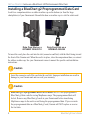
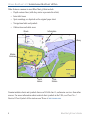
1
user’s guide
BlueChart
®
marine cartography
© Copyright 2006, 2007 Garmin Ltd. or its subsidiaries
Garmin International, Inc.
1200 East 151st Street, Olathe, Kansas 66062, USA
Tel: 913/397.8200 or 800/800.1020, Fax: 913/397.8282
e-mail: [email protected]
Garmin (Europe) Ltd.
Liberty House
Hounsdown Business Park,
Southampton, Hampshire, SO40 9RB UK
Tel. +44 (0) 870.8501241 (outside the UK) 0808 2380000 (within the UK)
Fax +44 (0) 870.8501251
email: [email protected]
Garmin Corporation
No. 68, Jangshu 2nd Road, Shijr, Taipei County, Taiwan
Tel: 886/2.2642.9199, Fax: 886/2.2642.9099
All rights reserved. Except as expressly provided herein, no part of this manual may be reproduced,
copied, transmitted, disseminated, downloaded or stored in any storage medium, for any purpose
without the express prior written consent of Garmin. Garmin hereby grants permission to download
a single copy of this manual onto a hard drive or other electronic storage medium to be viewed and
to print one copy of this manual or of any revision hereto, provided that such electronic or printed
copy of this manual must contain the complete text of this copyright notice and provided further
that any unauthorized commercial distribution of this manual or any revision hereto is strictly
prohibited.
Information in this document is subject to change without notice. Garmin reserves the right to
change or improve its products and to make changes in the content without obligation to notify any
person or organization of such changes or improvements. Visit the Garmin Web site
(www.garmin.com) for current updates and supplemental information concerning the use and
operation of this and other Garmin products.
Garmin®, BlueChart®, BlueChart g2®, GPSMAP®, and MapSource® are registered trademarks or
trademarks of Garmin Ltd. or its subsidiaries and may not be used without the express permission
of Garmin.
microSD™ and SD™ are trademarks of SanDisk Corporation, registered in the United States and
other countries.
February 2007
Part Number 190-00656-00 Rev. C
Printed in Taiwan
Portions of BlueChart data may be subject to the following copyrights and notices:
© 2005 MapTech, Inc.
The chart information in this product is reproduced, in whole or part, with the permission of the following national hydrographic offices and
other organizations: Australian Hydrographic Service; Editrice Incontri Nautici (Bolina); Hydrographic Institute of the Republic of Croatia;
Kort & Matrikelstyrelsen, Denmark, license no. G.9-2002; Estonian Maritime Administration (EMA) © 2006; Finland Hydrographic Office,
license no. FMA 877/721/2004; Service Hydrographique et Océanographique de la Marine (SHOM, www.shom.com), France, Contract nº
E 67/2005; Bundesamt für Seeschifffahrt und Hydrographie (BSH), Germany, license no. 8095-01/2004-02 ÖA03; © Her Majesty in Right
of Canada, Department of Fisheries and Oceans (2006), 20060101-G;.Great Barrier Reef Marine Park Authority (GBRMPA); Hellenic Navy
Hydrographic Service (Greece), license no. 171.7/22/03; Hydrographica chart data contained in this product is © 2005-2006 Hydrographica;
©Copyright Icelandic Coast Guard Hydrographic Department, (2004-2006). All rights reserved, license no. IS AC-001-Garmin; Imray
Laurie Norie & Wilson Ltd. UK; Istituto Idrografico della Marina, Italy; Maritime Administration of Latvia (LHS) © 2006; Maritime Safety
Queensland and is © State of Queensland. All rights reserved; Netherlands Hydrographic Office 2005-2006, license no. NL AC-002-Garmin;
Land Information New Zealand (Crown copyright reserved); Norwegian Hydrographic Service, license no. NO24/021001/1; ©Copyright
National Hydrographic Office, Sultanate of Oman (2005-2006), OM AC-001-Garmin. All rights reserved; ©Copyright Instituto Hidrográfico
of Portugal, (2003-2006), PT AC-002-Garmin. All rights reserved; Lewis Offshore Ltd. (© 2003-2006); Russian Hydrographic Office; South
Africa Hydrographic Office; ©Copyright Instituto Hidrográfico de la Marina, Spain, (2003-2006), ES AC-001-Garmin; Swedish Maritime
Administration, license no. 03-01453; and ©British Crown Copyright, (2001-2006), GB AC-002-Garmin. All rights reserved. Wavey Line
charts are produced, in part, from products and with the agreement of Wavey Line Ltd.
This product has been derived in part from material obtained from the UK Hydrographic Office with the permission of the UK Hydrographic
Office, Her Majesty’s Stationery Office and the following authorities: Hydrographic Department of the Icelandic Coast Guard, Netherlands
Hydrographic Office, National Hydrographic Office, Sultanate of Oman , Instituo Hidrográfico of Portugal, Instituto Hidrográfico de la Marina,
Spain.
This product has been derived in part from material obtained from the UK Hydrographic Office with the permission of the UK Hydrographic
Office, Her Majesty’s Stationery Office and the following port authorities for United Kingdom: Aberdeen Harbour Board, Associated
British Ports (includes Ayr & Troon, Barrow, Cardiff & Barry, Fleetwood, Garston, Ipswich, King’s Lynn, Lowestoft, Newport, Plymouth,
Silloth, Southampton, Swansea & Port Talbot, and Teignmouth), Cattewater Harbour Commissioners (Cattewater, Plymouth), Chichester
Harbour Conservancy, Clydeport Operations Limited, Cromarty Firth Port Authority, Cowes Harbour Commission, Dart Harbour and
Navigation Authority, Dover Harbour Board, Falmouth Harbour Commissioners, First Corporate Shipping Limited (Bristol), Fowey Harbour
Commissioners, Fraserburgh Harbour Commissioners, Gloucester Harbour Trustees, Harwich Haven Authority, Heysham Port Limited, Imerys
Minerals Ltd (Par), Inverness Harbour Trust (Inverness, Inverness Firth), King’s Lynn Conservancy Board, Langstone Harbour, Larne Harbour
Limited (Larne, Cairnryan), Littlehampton Harbour Board, Londonderry Port and Harbour Commissioners, Manchester Ship Canal Company,
Medway Docks and Harbour Company Limited, Mersey Docks & Harbour Company (Mersey, Liverpool, Birkenhead), Milford Haven Port
Authority, Montrose Port Authority, Newhaven Port and Properties Limited, Orkney Islands Council, Padstow Harbour Commissioners, PD
Teesport (excluding Bathymetry data), Poole Harbour Commissioners, Port of Boston Limited, Port of London Authority, Port of Sunderland,
Port of Tyne Authority (Tyne), Port of Wisbech Authority, Port of Workington, Portland Harbour Authority Limited, Ports of Truro & Penryn,
Portsmouth Commercial Port, Seaham Harbour Dock Company, Scrabster Harbour Trust (Scrabster), Shetland Islands Council, Shoreham Port
Authority, Stena Line Ports Limited (Fishguard, Fleetwood, Holyhead, Stranraer), Teignmouth Harbour Commission, Thanet District Council
(Ramsgate), Torbay Council Marine Services (Tor Bay; Torquay, Brixham, Paignton), Warrenpoint Harbour Authority, Weymouth & Portland
Borough Council, and Whitstable Harbour. For Channel Islands: Jersey Harbours and States of Guernsey Harbour Authority. For Isle of Man:
Isle of Man Harbours Division. For Republic of Ireland: Bantry Bay Harbour Commissioners, Drogheda Port Company, Dublin Port Company,
Dun Laoghaire Harbour Company, and Port of Cork Company. © the British Crown, 2001-2006. All rights reserved.
Some data and information contained in these Products are © Commonwealth of Australia, Australia Hydrographic Service, Maritime Safety
Queensland and is © State of Queensland, Certain zoning information in this product is © Great Barrier Reef Marine Park Authority; and is
used under license with the permission of the Great Barrier Reef Marine Park Authority. All rights reserved. Apart from the uses permitted to
the licensee under the license, the information may not be modified or exploited by reverse engineering of formats and encryption or copied,
reproduced, translated, or reduced to any electronic medium or machine readable form, in whole or part, without the prior written consent of
the Great Barrier Reef Marine Park Authority, the Maritime Safety Queensland and © 2002-2006 Her Majesty the Queen in Right of Canada,
Canadian Hydrographic Service / Sa Majesté du chef en Canada, Service Hydrographique du Canada and/or Nautical Data International,
Inc. Garmin International, Inc. is an authorized user and licensee of selected Australia Hydrographic Service data products under licensing
agreement 0548FL and Nautical Data International Inc. data products under Licensing Agreement number 240502001-001/2 and 021704-087.
Apart from the uses permitted to the licensee under the licensing Agreements, the information may not be modified or exploited by reverse
engineering of formats or encryption or copied, reproduced, translated or reduced to any electronic medium or machine readable form, in whole
or part.
Reeds Almanacs port services data contained in this product is © 2004-2006 Adlard Coles Nautical. Certain port services data contained
in this product is © 2005-2006 Batmagasinet, Certain port services data contained in this product is © 2006 Boatlaunch Ltd., © 2005-2006
BLOC MARINE Almanac & Cruising Guide, © 2004-2006 Bolina - Editrice Incontri Nautici, © 2005-2006 Gasthamnsguiden SXK AB, and
© 2005-2006 Kort & Matrikelstyrelsen. The Explorer Charts logo is a registered trademark of Lewis Offshore Ltd., publishers of the Explorer
Chartbook series. Photos courtesy of © 2006 CMT Group 1, Inc. and Garmin International, Inc.
** BlueChart g2 does not contain photos for all cards. Garmin is continuing to expand our growing database of navigationally significant photos
** Navteq road data is included for many BlueChart g2 data cards. Not all data cards contain road data.
** Whereis ®. Map data is included in Australia BlueChart g2 data cards. Whereis © 2006 Telstra Corporate Limited and its licensors.
WARNING:No national hydrographic office has verified the information in this product or quality assured it, and none accept liability for
the accuracy of reproduction or any modifications made thereafter. No national hydrographic office makes any warranties or representations,
express or implied, with respect to this product. No national hydrographic office warrants that the product satisfies national or international
regulations regarding the use of the appropriate products for navigation or that it contains the latest hydrographic information available.
WARNING:All charts are digitized directly from existing government and other official charts and should not be used solely for navigation.
Digital charts are intended to be used as an aid to traditional navigational charts, not as a replacement. Only official government charts and
notices to mariners contain all information needed for the safety of navigation, and as always, the captain is responsible for their prudent
use. A prudent navigator never relies on any single source of navigational information. Garmin strives to provide its customers with the most
economical, accurate and up-to-date electronic maps available. However, features are continually changing, so the data may not reflect the latest
modifications and/or additions in your area. Garmin makes no warranty as to the accuracy or completeness of the map data.
WARNING:Garmin BlueChart data and bottom information are for navigation reference only, as bottom conditions are continually changing.
This product is for general reference.
WARNING:Some of the information in this product may have been produced, in part or whole, from withdrawn national hydrographic office
products. New charts and/or NTM corrections will render this product obsolete and inaccurate.
WARNING:The Great Barrier Reef Marine Park Authority (“the Authority”) does not check the information in this product and accepts no
liability for the accuracy of copying or for any modifications that may have been made to the information which it has supplied. Use of and
entry to the Great Barrier Reef Marine Park is controlled by the Great Barrier Reef Marine Park Act 1975 (Cth) (“the Act”). Penalties apply
for use of or entry to a zone for a purpose other than for a purpose permitted under the Great Barrier Reef Marine Park Zoning Plan 2003 (“the
Zoning Plan”) prepared by the Authority pursuant to section 32 of the Act. This product does not contain all information concerning permitted
use or entry under the Zoning Plan. For purposes of use of or entry to the Great Barrier Reef Marine Park, this product should only be used in
conjunction with the Zoning Plan and the Great Barrier Reef Marine Park Regulations 1983 (Cth). For purposes of navigation, users should
consult official navigation charts released by relevant government authorities.
WARNING:The Licensee is hereby advised of the Canadian carriage regulations applicable to Canadian ships in all waters and to all ships in
waters under Canadian jurisdiction which requires the master and owner of every ship to: have on board, in respect of each area in which the
ship is to be navigated, the most recent editions of the charts, documents; or to have sufficient knowledge of specific information, such that safe
and efficient navigation in the area where the ship is to be navigated is not compromised.
WARNING:The tide and current predictions derived from this software are not to replace the Canadian Tide and Current Tables, which are
required under the Charts and Nautical Publications Regulations of the Canada Shipping Act and which must be used for navigation within
Canadian waters. Official Canadian Tide and Current Tables are available from authorized chart dealers. For a complete list of dealers in your
area, please contact:
Chart Distribution Office
Canadian Hydrographic Service
615 Booth Street
Ottawa, Ontario, K1A 0E6
Telephone: (613) 998-4931
Fax: (613) 998-1217
Email: [email protected]
WEB: www.charts.gc.ca
Although CHS produces the tide and current constituent data used in this software with the greatest care, neither Canada, its ministers, officers
and employees, nor CHS, who individually and collectively shall hereinafter be referred to as “Canada”, make any representation or warranty,
either express or implied, concerning the accuracy of the Canadian data, or that it is suitable for any particular application or purpose. In
no event will Canada be liable for any damages whatsoever, including but not limited to loss of revenue or profit, lost or damaged data, and
expenses, arising in any way from or consequential upon the use of, or the inability to use this Canadian tide and current constituent data.
Tide and current predictions derived from this software may not be used commercially without a license from Canadian Hydrographic Service,
Department of Fisheries and Oceans. Please contact the Canadian Hydrographic Service’s Chart Distribution Office at the above address for
more information.
EXPLORERCHARTS
R
Introduction > Overview
Introduction
BlueChart® g2 is Garmin’s exclusive line of highly-detailed marine cartography. BlueChart
g2 cartography features smoother layering and better integration of map graphics for faster
redraws and more cohesive panning, scrolling, and zooming.
Overview
Blue Chart g2 features richer colors and shading for easier interpretation and improved
visibility. BlueChart g2 has all the detail of traditional BlueChart, but with additional
functions, such as an optional “mariner’s-eye view” map perspective. With BlueChart g2
preprogrammed data cards, you can access costal roads and points of interest (POIs) as well as
a growing worldwide database of high-quality navigationally significant photos. These photos
give “real picture” detail for many harbors, ports, marinas and coastal features.
BlueChart g2 cartography features a growing database of aerial
photography to give mariners a visual overview of harbors,
marinas, waterways, and other points of reference.
BlueChart g2 User’s Guide
Introduction > Introduction
Additional BlueChart g2 enhancements include:
• Shaded depth contours
• Mariner’s eye view map perspective
• Port plans and navigationally significant photos
• Improved IALA symbology
• Intertidal zones with spot soundings
• Navaids with view range and coverage
• Data on tides and currents
• Coastal roads, marinas, points of interest
• Wrecks, restricted areas, anchorages
• Shoals, spoilage, and more
Like all BlueChart cartography, BlueChart g2 cartography is styled to match the appearance
of paper charts when displayed on your Garmin chartplotter. Sharp, colorful, finely detailed
graphics let you see every cartographic contour and feature, with minimal panning and
zooming to bring the chart data into focus.
ii
BlueChart g2 User’s Guide
Introduction > Table of Contents
Table of Contents
Introduction....................................................................................................... i
Overview...................................................................................................................i
Warning...................................................................................................................iv
Getting Started................................................................................................. 1
Installing a BlueChart g2 Preprogrammed Data Card.........................................2
Viewing BlueChart g2 Information................................................................. 3
Understanding BlueChart g2 Data.........................................................................3
Accessing Additional Object Information.............................................................5
Viewing Photos..................................................................................................................6
Accessing Paper-Chart-Specific Information.................................................................... 7
Understanding the Differences Between Electronic and Paper Charts.............8
Reporting Chart Errors...................................................................................................... 8
Viewing Tide and Current Information..................................................................9
Appendix........................................................................................................ 10
Caring for Your BlueChart g2 Data Card.............................................................10
Reading the ID Code on a BlueChart g2 Card....................................................10
Purchasing BlueChart g2 Cards....................................................................................... 10
Warranty Information............................................................................................11
Product Registration.............................................................................................11
Contact Garmin.....................................................................................................11
Index............................................................................................................... 12
BlueChart® g2 Data Card Order Form.......................................................... 13
BlueChart g2 User’s Guide
iii
Introduction > Warning
Warning
Failure to avoid the following potentially hazardous situations could result in an
accident or collision resulting in death or serious injury.
When navigating, carefully compare BlueChart g2 information to all available navigation
sources, including information from visual sightings, and paper maps. For safety, always
resolve any discrepancies or questions before continuing navigation.
Use the electronic BlueChart g2 cartography only to facilitate, not to replace, the use of
authorized government charts. Official government charts and notices to mariners contain all
information needed to navigate safely.
iv
BlueChart g2 User’s Guide
Getting Started > Getting Started
Getting Started
Garmin BlueChart g2 preprogrammed data cards are available in a region-by-region format.
To find out what region or regions will work best for you, please consult your local Garmin
marine dealer or visit the Garmin Web site at www.garmin.com. From the Maps & Charts
section of the Garmin Web site, you can view the listing of available BlueCharts, the areas
of coverage, and the paper charts contained within each card. A printed list is also available,
which lists Garmin’s current BlueChart g2 cards, part numbers, and the latest pricing.
Note: Garmin BlueChart g2 preprogrammed data cards work only with
BlueChart g2 compatible Garmin units. Look for the BlueChart g2 compatible logo
on the product packaging.
Current owners of Garmin GPSMAP 276, GPSMAP 376, GPSMAP 3005C, GPSMAP 3006C,
and GPSMAP 3010C chartplotters can also use BlueChart g2 preprogrammed data cards after
loading a required software update.
BlueChart g2 User’s Guide
Getting Started> Installing a BlueChart g2 Preprogrammed Data Card
Installing a BlueChart g2 Preprogrammed Data Card
Look for a compartment door or rubber weather cap on the bottom (or front for large
chartplotters) of your Garmin unit. Beneath the door or weather cap is a slot for a data card.
Data Card Slot on a
GPSMAP 3206/3210
Data Card Slot on a
GPSMAP 492/498
To insert the card, place the card into the slot (connector end first) with the label facing toward
the front of the Garmin unit. When the card is in place, close the compartment door, or reinsert
the rubber weather cap. See your Garmin unit owner’s manual for specific card installation
instructions.
Caution
Insert the connector end of the card into the card slot. Improper installation can result in
damage to your Garmin unit and can void your warranty.
Caution
BlueChart g2 Preprogrammed Data Card Caution: Do NOT use preprogrammed
BlueChart g2 data cards for saving MapSource maps. The preprogrammed data will
be lost. Remove any BlueChart g2 cards in your Garmin unit before transferring
MapSource maps to the unit to avoid losing the preprogrammed data. If you overwrite
the preprogrammed data on a BlueChart g2 card, Garmin will NOT replace or recover
the lost data.
BlueChart g2 User’s Guide
Viewing BlueChart g2 > Understanding BlueChart g2 Data
Viewing BlueChart g2 Information
BlueChart g2 technology for the coastal United States (including Alaska and Hawaii)
is preloaded on Garmin’s GPSMAP 492 and GPSMAP 498 chartplotters, as well as its
large- display GPSMAP 2200 series and GPSMAP 3200 series of chartplotters.
To access additional BlueChart g2 functionality, you can purchase preprogrammed data cards.
These BlueChart g2 data cards include highly detailed coastal roads and points of interest such
as restaurants, lodging, local attractions, and more. Full-color aerial photos of ports, marinas,
bridges, and navigational landmarks are also included on many data cards. See page 6 for
information on viewing photos while using a preprogrammed data card.
Understanding BlueChart g2 Data
BlueChart g2 electronic charts use graphic symbols to denote map features. Some common
symbols you might see include, but are not limited to, the following*:
Airport/Seaplane Base
Dangerous Rock
Pilot Boarding Area
Anchorage Berth
Explosive
Precautionary Area
Anchoring Prohibited
Exposed Rock
Radio Report Point
Beacon
Exposed Wreck
Recommended Anchorage
Building
Fishing Harbor
Rescue Station
Buoy Fishing Prohibited
Tide Station
Church
Information
Yacht Harbor
Current Station
Marina Services
*Some symbols might appear differently on your Garmin chartplotter.
BlueChart g2 User’s Guide
Viewing BlueChart g2 > Understanding BlueChart g2 Data
Other features common to most BlueChart g2 data include:
• Depth contour lines (with deep water represented in white)
• Inter-tidal zones
• Spot soundings, as depicted on the original paper chart
• Navigational aids and symbols
• Obstructions and cable areas
Wreck
Information
Buoy
Marina
Services
Yacht
Harbor
Tide
Station
Garmin includes charts and symbols shown on NOAA chart 1, and marine services from other
sources. For more information about nautical chart symbols in the USA, see Chart No. 1
Nautical Chart Symbols Abbreviations and Terms at www.noaa.com.
BlueChart g2 User’s Guide